Article

Revitalization of Traditional Villages Oriented to SDGs: Identification of Sustainable Livelihoods and Differentiated Management Strategies

1
School of Architecture and Urban Planning, Beijing University of Civil Engineering and Architecture, Beijing 100044, China
2
Urban and Rural Heritage Data Research Institute, Beijing University of Civil Engineering and Architecture, Beijing 100044, China
*
Author to whom correspondence should be addressed.
Buildings 2025, 15(7), 1127; https://doi.org/10.3390/buildings15071127
Submission received: 27 February 2025 / Revised: 21 March 2025 / Accepted: 23 March 2025 / Published: 30 March 2025

Abstract

:
Livelihood diversification for traditional villages is essential to reducing poverty, addressing rural hollowing, and achieving the Sustainable Development Goals (SDGs). Shanxi Province—with its wealth of ancient villages, diverse cultural heritage, and unique landscapes—serves as a critical case for analyzing livelihood strategies. This research proposes a framework for livelihood diversification in Shanxi Province’s 619 traditional villages. Firstly, we constructed an indicator system to measure livelihood assets, including ecological stability, economic feasibility, land productivity, cultural inheritance, and social service capacity. Then, the trade-offs and synergies between each pair of assets are explored based on the correlation tests and the Geographically Weighted Regression (GWR) model. Finally, the Self-Organizing Map (SOM) model is employed to cluster the dominant livelihood assets of the sample villages. The results indicated that (1) the current sustainable livelihood levels of traditional villages in Shanxi Province exhibit spatial differentiation and imbalance. (2) The analysis confirms significant synergy between cultural inheritance, social service capacity, and economic feasibility, suggesting that appropriate protection and enhancement of local culture positively correlates with sustainable economic and social development in the villages. (3) Utilizing the SOM clustering model, six distinct types of sustainable livelihood strategies for traditional villages in Shanxi Province were successfully identified. Furthermore, a county-scale “multi-livelihood zoning” strategy has been proposed. The findings of this research can serve as a valuable reference for strategic planning and the implementation of rural revitalization.

1. Introduction

A proper sustainable livelihood framework (SLF) plays an important role in achieving rural revitalization and the 17 Sustainable Development Goals (SDGs). At present, China’s traditional villages are characterized by their large numbers, widespread distribution, and diverse livelihood assets. Meanwhile, rural tourism has grown rapidly by leveraging tangible and intangible cultural resources. While this has reshaped rural livelihood strategies, it has also caused agricultural fragmentation and environmental degradation [1]. To address these challenges, the SLF serves as a practical tool for villages by assessing existing livelihood resources and designing tailored strategies. It can help curb rural depopulation, enable sustainable rural transitions [2,3,4,5], and adhere to SDGs [6,7].
The rapid shift in rural lifestyles and livelihood activities has exposed critical management challenges. Firstly, tourism expansion in certain regions [8] and uniform “one size fits all” policies—where standardized methods are applied indiscriminately to villages in different contexts [9,10,11]—can lead to the mismanagement of land resources and other challenges in village revitalization. Consequently, effective rural development policies must be based on an accurate classification of the essential characteristics of the village types [12]. Second, more attention needs to be paid to the interlinkages between different assets, such as trade-offs and synergies. This will facilitate a more accurate assessment and prioritization of these assets in the policy development process [13,14]. Third, decision-making tools could be faster. Single village samples or small village group samples were used as research objects, which inevitably resulted in a long data acquisition cycle and low decision-making efficiency [15]. There is an urgent need for a decision program that can integrate massive spatial data with machine recognition clustering technology.
The objectives of this paper are as follows: Initially, the modified SLF for traditional villages is proposed, with SDGs serving as the primary reference indices. Subsequently, we explore the trade-off and synergy mechanism between various livelihood assets, including ecological stability, economic feasibility, land productivity, cultural inheritance, and social service, to explore the possibility of coordinated development of resources. Furthermore, this study employs the SOM clustering model to delineate and categorize the village assets. In the end, the research synthesizes the identified spatial development patterns and livelihood strategies and offers a set of proposed strategies aimed at advancing sustainable village livelihoods. This study can also be used for the documentation and periodic monitoring of villages, providing ideas for the sustainable development management of traditional villages.

2. Literature Review

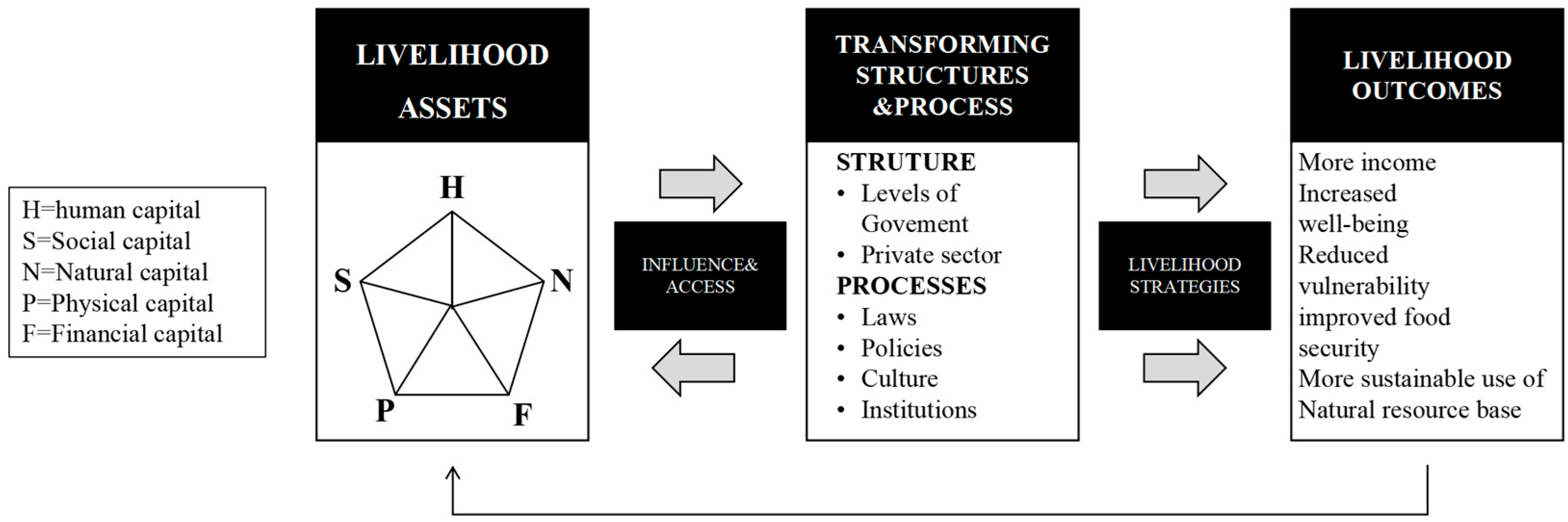
2.1. A Sustainable Livelihood Framework for Traditional Villages

‘Livelihoods’, as a term, can be summarized simply as the means by which people make a living. Meanwhile, a working definition of livelihoods is described by Chambers and Conway as the combination of capabilities, assets (reserves, resources, rights, and access), and activities that people need to make a living [16,17]. Since the early 1990s, the SLF has become a mainstream approach in the field of rural studies. Scoones first proposed SLF in 1998, which was subsequently revised by the UK Department for International Development (DFID) in 1999 [16,17] and quickly became an important guiding tool for governments and multilateral and non-governmental organizations in development interventions, providing decision support for poverty reduction strategies [18].
In the original SLF, livelihood assets are typically categorized into the following types: natural capital, comprising natural resources such as land, water, forests, and biodiversity; human capital, which encompasses an individual’s skills, knowledge, health, and labor force; physical capital, including infrastructure and means of production like housing, transportation, and equipment; and financial capital, referring to the availability of funds, savings, and credit (Figure 1). These assets are combined in various activities related to livelihood strategies.
The study of the sustainable livelihood of traditional villages is based on this original framework, but many studies generally point out that the framework should be expanded according to its cultural particularity. Cultural capital has been widely recognized as a core complementary dimension in many research studies. For example, Zhang et al. [19] confirmed in the study of ancient villages in Yunnan that cultural capital (such as traditional skills and festival customs) is directly transformed into economic benefits through tourism commercialization and non-genetic inheritance, which significantly enhance the resilience of communities to resist the impact of modernization. Similarly, Ma et al. [8] revealed the directional influence of cultural capital on rural tourism livelihood strategies, emphasizing its irreplaceability in SLF. These studies showed that cultural capital is not only the core component of livelihood resources but also a key driving force for the differentiation and sustainable transformation of traditional villages.
Meanwhile, in view of the unique value of traditional villages in multiple dimensions, many international organizations have formed a systematic consensus. The International Scientific Committee on Cultural Landscapes (ICOMOS-ISSCL) highlights the irreplaceable value of ancient villages in the preservation of biodiversity, the security of land and food, and the dissemination of traditional culture [20,21]. Concurrently, a report by the Food and Agriculture Organization (FAO) indicates that the productivity, stability, resource conservation, economic viability, and social acceptability of regions are essential components for supporting Sustainable Development Goals [22].
Therefore, the SLF for traditional villages should be designed as a multi-dimensional system, covering multiple dimensions such as cultural capital, natural capital, physical capital, financial capital, and social capital. The development of this framework is contingent upon an in-depth examination and refinement of the SLF [23], while also drawing insights from studies on Rapid Rural Appraisal (RRA) [24]. In the context of this study, cultural capital denotes the tangible historical remnants/built heritage, traditional culture, folklore, languages, arts, and other intangible cultural heritage within the village, which are pivotal in sustaining community identity and attracting external resources [8]. Natural capital refers to the village’s natural resources, comprising agricultural land, forests, water resources, biodiversity, and ecosystem services. In this context, it is primarily considered a landscape asset that facilitates economic activities such as eco-tourism. Physical capital is concerned with the village’s production tools and technologies, with a focus on ensuring food security and enhancing the productivity/efficiency of the land [25,26]. Financial capital encompasses the economic status of the village and its residents, including monetary resources, investment opportunities, and credit channels, which are crucial for supporting livelihood activities and economic advancement [8]. Social capital focuses on describing social networks, facilities, and mutual assistance relationships in and around villages, all of which are fundamental to fostering community cohesion and collaborative efforts [27].
It is essential to clarify that the analytical perspective adopted in this study is at the village level, as opposed to the household level. Different units of analysis represent different research scales and concerns [23]. For example, Alark [28] studied 72 villages in India’s Panchayat region, combining the SLF with resilience theory to assess livelihood vulnerability under climate change. While multi-scale analysis (individual, local, and regional) is widely accepted and SLF can be applied across scales [29], most studies still focus on household-level analysis, with regional-level studies remaining scarce.

2.2. Multiple Path of Traditional Village Livelihood Strategy

At present, the livelihood strategy of traditional villages has broken through the traditional model, forming multiple paths such as cultural tourism, ecological agriculture, and handicraft revival. Among them, rural tourism is regarded as the core path of the livelihood transformation of traditional villages [30,31,32]. The case study shows that moderate tourism development can increase the income of villagers. For example, the ancient towns in the Yangtze River Delta can realize community sharing through the ticket-sharing mechanism [33]. However, excessive commercialization can easily lead to cultural alienation and environmental pressure [34]. Meanwhile, ecological agriculture activates the traditional agricultural value through the “integration of three industries” (production–processing–cultural tourism), for example, the rice–fish symbiotic system of the Guizhou Dong nationality can achieve win–win ecological and economic benefits [35]. Handicraft relies on intangible cultural heritage IP authorization and e-commerce platform marketing (such as Suzhou embroidery and Huizhou wood carving) to promote craft branding and market expansion [36].
However, livelihood diversification still faces challenges regarding optimization paths: at the theoretical level, existing studies focus on single capital (such as culture or ecology) and lack a systematic analysis of cross-capital coordination mechanism; at the practical level, the problem of “one size fits all” is prominent in policy implementation, and the difference in village resource endowment is ignored, such as the dilemma of the homogenization of tourism characteristic towns [33]; and at the technical level, the application of digital tools is still in the data collection stage, with a lack of effective connection to livelihood strategies.

2.3. Decision-Making Tools Utilized in Rural Areas Studies

In rural area studies, the utilization of decision-making tools is essential for comprehending the intricate socio-economic dynamics of rural areas. Among these tools, Participatory Rural Appraisal (PRA) and Multi-criteria Decision-making (MCDM) are both popular. PRA, as a completely bottom-up approach, largely encourages the active involvement of stakeholders [37,38]. It employs methods such as semi-structured interviews (both individual and group discussions), resource sketch mapping, daily calendars, timelines, and direct observations to delve into the needs of various stakeholders and address conflicts of interest among them. In the study of water resource management in the Al-Mujaylis region of the Tihama coastal plain in Yemen, for instance, PRA was employed as a bottom-up approach. This method facilitated the assessment of community needs and effectively mediated the discrepancies among farmers, government officials, and environmental activists. Consequently, a collaborative water resource management plan was formulated [39]. Similarly, MCDM is a commonly used comprehensive decision-making tool [40], which tends to assign weights to different decision criteria, helping researchers to make decisions in a more quantitative framework. AHP is one of the MADM methods that assign different weights to indicators by comparing pairs between sub-indicators [41]. This approach has been widely used in urban planning, particularly for site selection and suitability analysis. Upon summarizing the validity and limitations of the various decision tools discussed, we found that the PRA approach excels in promoting stakeholder engagement and leveraging local knowledge but is often used in situations where complex data such as social, ecological, etc., are lacking. Because it is obviously not efficient enough when processing large amounts of data, it is suitable for study cases with a small number of samples. In contrast, MCDA has an advantage in providing clear, quantitative decision support for a large number of data objects.
In addition, the current research on Chinese traditional villages still has limitations in terms of geographical scope and research methods. Current research and work on traditional villages are mainly carried out using field investigation, photography, and questionnaires. The collection of village data through such methods is usually limited by various factors (workforce, material resources, and time costs), and the sensitivity and universality are weak [42]. In addition, there is an imbalance in the quantity and quality of research on traditional villages in northern versus southern China. Current research focuses on southern China’s traditional villages. In particular, in Jiangsu, Zhejiang, and other provinces [43], a village-level statistical system similar to the “village card” was established earlier, providing a more convenient way to obtain data and evaluate rural research [44]. In contrast, the research results and guidance for northern areas are limited [45].

3. Materials and Methods
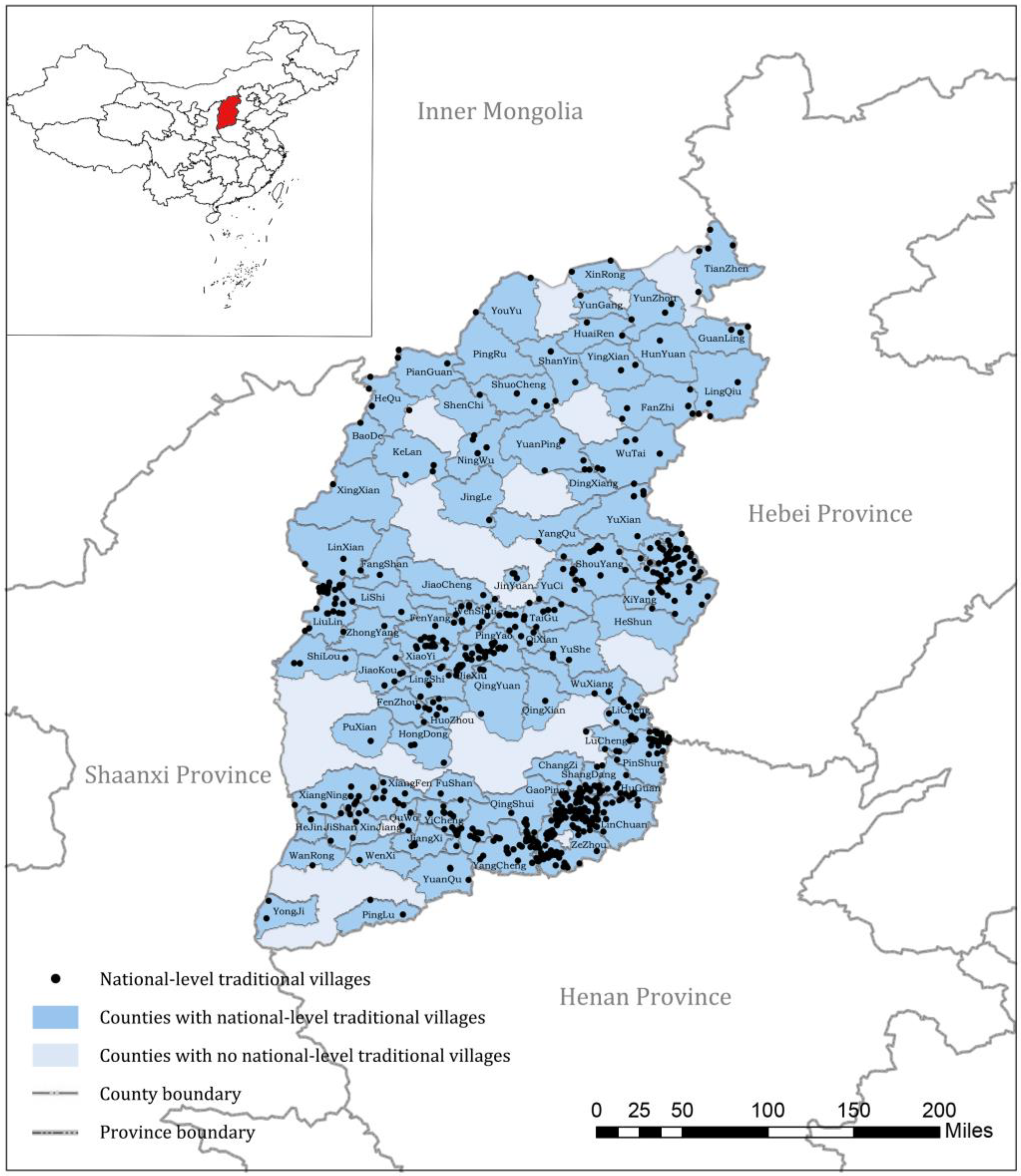
3.1. Study Area

This study takes Shanxi Province, a typical central region of China, as the research scope and selects 619 National Traditional Villages in Shanxi Province as the research objects (Figure 2). The selection of samples from the list of National Traditional Villages ensures the typicality of villages. At the same time, National Traditional Villages have more funds and policy support, with development advantages and research significance. At the same time, as one of the provinces with distinct natural features and cultural characteristics in central China, Shanxi Province has the second largest number of national-level traditional villages after Zhejiang and Guizhou. Therefore, it is of great research value and urgency to explore the sustainable development path of traditional villages in Shanxi. In addition, Shanxi Province has a strong representation and reference value, which can provide a reference for traditional village policy management in other areas.

3.2. Data Source

The data sources of this study cover multiple authoritative platforms and statistical yearbooks, which ensure the richness and reliability of the data, including map boundaries, city and county administrative division data (2022) from the Resource and Environment Data Cloud Platform, village data from the Chinese Traditional Villages Network, the Ministry of Urban and Rural Affairs and Construction, and the Ministry of Culture-recognized list of traditional villages. Geographic coordinates were extracted using the Baidu map data method and converted into vector data, DEM elevation data, land use data, and other related geographic data, mainly obtained from the National Common Service Platform for Geospatial Information, the Geo-Remote Sensing Eco-Network Platform and the data center Chinese Academy of Sciences Resources and Environmental Sciences. The socio-economic statistics and population data were mainly from the Shanxi Statistical Yearbook and County Statistical Yearbook, and the scenic area data were from the list of A-class tourist attractions in Shanxi Province issued by the Shanxi Provincial Department of Culture and Tourism in 2022.
All data were collected in 2022. Since rural data collection usually has a long period and has changed little in recent years, it could be argued that possible errors in data collection have a negligible impact on the final research results. Meanwhile, all data were matched at the spatial scale, and the consistency of the data was verified. For the missing data, we used appropriate interpolation or imputation methods to ensure the scientific validity of the analysis results.

3.3. Methods

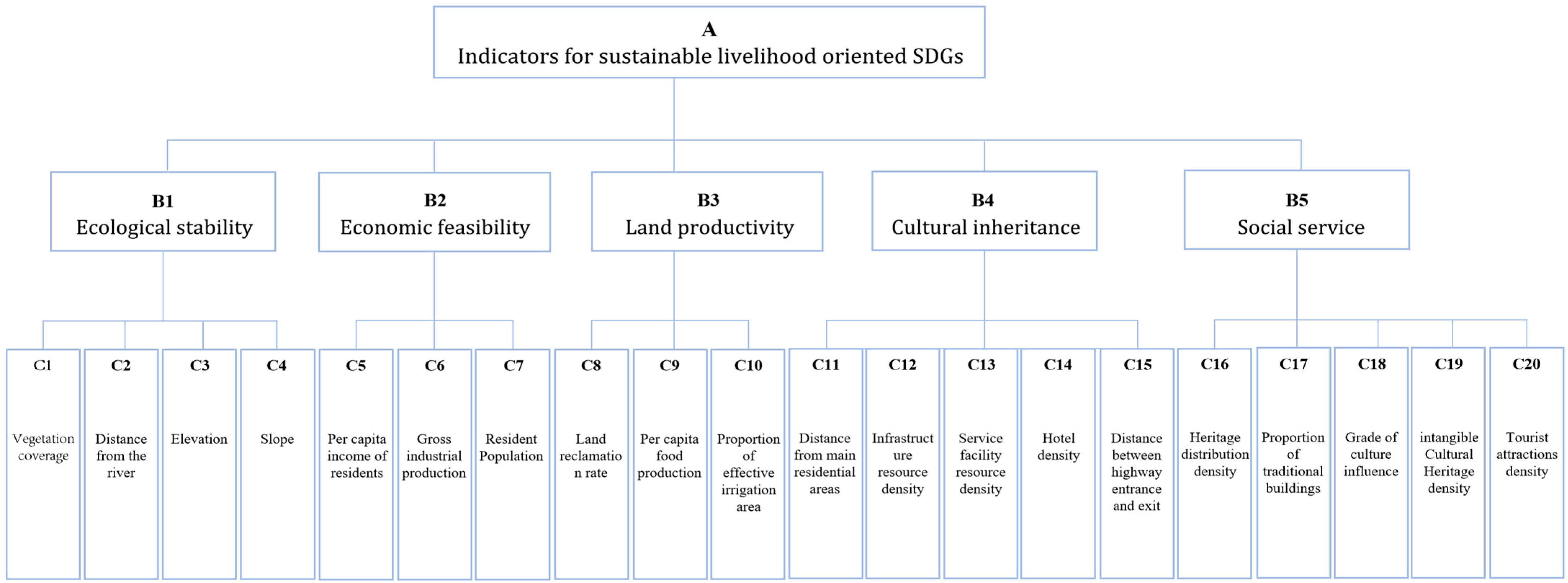
3.3.1. Indicators for Sustainable Livelihood Assessment Oriented to SDGs

This study constructed a sustainable livelihood evaluation model of traditional villages for SDGs, integrating five key dimensions: ecological stability, economic feasibility, land productivity, cultural inheritance, and social service capacity. The determination of these five dimensions comes from the literature review. In determining the specific sub-indicators, we referenced the specific targets and indicators of the SDGs and incorporated research from other academic colleagues [22,46,47,48,49]. In addition, we also considered the availability of relevant data to ensure the practicality and applicability of the evaluation model. Finally, 20 evaluation sub-indicators were determined (Figure 3).
Table 1 provides detailed explanations of the weight allocation rules and definitions for each hierarchical indicator and establishes mapping between each sub-indicator and the relevant SDGs. Based on SDG6 and SDG15, the ecological target layer includes four indicators: vegetation coverage, elevation, slope, and distance from rivers. These indicators are used to assess the current status of natural resources in traditional villages. Drawing on SDG1 and SDG8, we selected the per capita income of residents, gross industrial production, and resident population density as economic feasibility indicators. These focus on the village economy’s long-term capacity to maintain high levels of output [50]. To align with the protection and safeguarding of the World Cultural and Natural Heritage outlined in SDG11.4, five indicators were chosen: heritage distribution density, proportion of traditional buildings, cultural influence, intangible cultural heritage density, and density of A-grade scenic spots. This aim is to evaluate cultural assets from multiple dimensions, including historical, artistic, and use value. Guided by SDG2, three characteristic indicators reflecting village food security and agricultural production capacity were selected: land reclamation rate, per capita food production, and the proportion of effectively irrigated areas. These indicators correspond to the SDG2.4 emphasis on sustainable agriculture. Social service levels, guided by SDG9 and SDG11, focus on the richness and complexity of village social networks and facilities. Accessibility was assessed using distances to roads, airports, and train stations. Additionally, previous studies have validated the accuracy of using Point of Interest (POI) data to represent facility points for evaluating urban social networks [51]. Therefore, we also calculated the density of hotels, infrastructure, and services to assess village amenities. All these indicators were constructed and selected to better monitor and evaluate the sustainability of livelihoods in traditional villages and achieve the SDGs at this level.
In order to determine the weight of each indicator, we used the AHP method. In this process, we invited 10 experts, including professors and engineers, from the fields of urban and rural planning, traditional villages, rural tourism, and heritage preservation. These experts compared and scored each matrix in pairs. Then, we used Yaahp software to check the consistency of the evaluation matrix and calculated the weight value of each sub-index accordingly.
When evaluating a sub-indicator, we assigned a score of 1, 0.8, 0.6, 0.4, and 0.2 to its good or bad performance based on a five-point scale. For indicators that can be directly quantified, we used ArcGIS software to conduct spatial calculations to determine their scores. For those indicators that require subjective judgment, we relied on expert evaluation to score them to ensure the objectivity and accuracy of the evaluation results. Finally, we deduced the spatial distribution characteristics of the total score of each dimension through the weighted superposition formula, which is calculated as follows:
Z j = i = 1 n W i C j i
In Equation (1), Zj denotes the total score of the jth village, Cji denotes the score of each index corresponding to the j village, Wi denotes the weight of each indicator, and n denotes the number of sub-indicators.

3.3.2. The Correlation Test and Geographically Weighted Regression

The livelihood sustainability of traditional villages is a dynamic process and its five aspects interact. One of the objectives of this research is to visualize the trade-offs or synergies between five aspects. First, on a mathematical level, the corrplot package in the R4.0 software can be used to achieve Pearson correlation analysis at two spatial scales: village and county. Secondly, at the spatial level, the Geographically Weighted Regression (GWR) model is used to establish a spatial weighting matrix, with county as the analysis unit, to determine the spatial relationships between the different aspects. In addition, since we only use the indicator variables as independent and dependent variables, there is no multicollinearity between the independent variables and the use of nominal or decomposed data. The GWR model is calculated as follows:
y i = β 0 ( μ i , v i ) + k = 1 p β k ( μ i , v i ) x j k + ε i
where ( μ i , ν i ) is the spatial location of point i ; p is the number of independent variables; y i is the dependent variable; x j k is the independent variable; ε i is the random error; β 0 ( μ i , ν i ) denotes the intercept at point i ; and β k ( μ i , ν i ) denotes the regression coefficient. Like the Pearson correlation analysis, positive regression coefficients indicate spatial synergies, while negative regression coefficients indicate spatial trade-offs. The GWR model was executed at the county scale using the GWR model package in the R4.0 software.

3.3.3. The Self-Organizing Maps (SOMs)

This study concludes by using self-organizing maps (SOMs) to identify the sustainable advantages of traditional villages. SOMs, a widely used clustering method in environmental sciences, largely exclude the influence of human subjective factors and are suitable for clustering studies of large numbers of indicators associated with a species [52,53]. It is an unsupervised artificial neural network that allows individuals with similarities in a large input dataset to move closer together. Therefore, academics often use it to cluster data without knowing the categories or to identify feature types intrinsically related to a particular problem. It has been shown that self-organizing feature mapping neural networks can be applied in research areas such as ecosystem assessment [54], weather clustering [55,56], and landscape identification [57]. Therefore, in this study, the SOM clustering model is used to identify scoring units with similarities at both county and village scales according to the five types of indicator scores and is then imported into ArcGIS for spatial mapping and visual representation, which is used as a basis for classifying traditional villages and formulating management strategies. This study used the Kohonen package of the R4.0 software to carry out the SOM.

4. Results

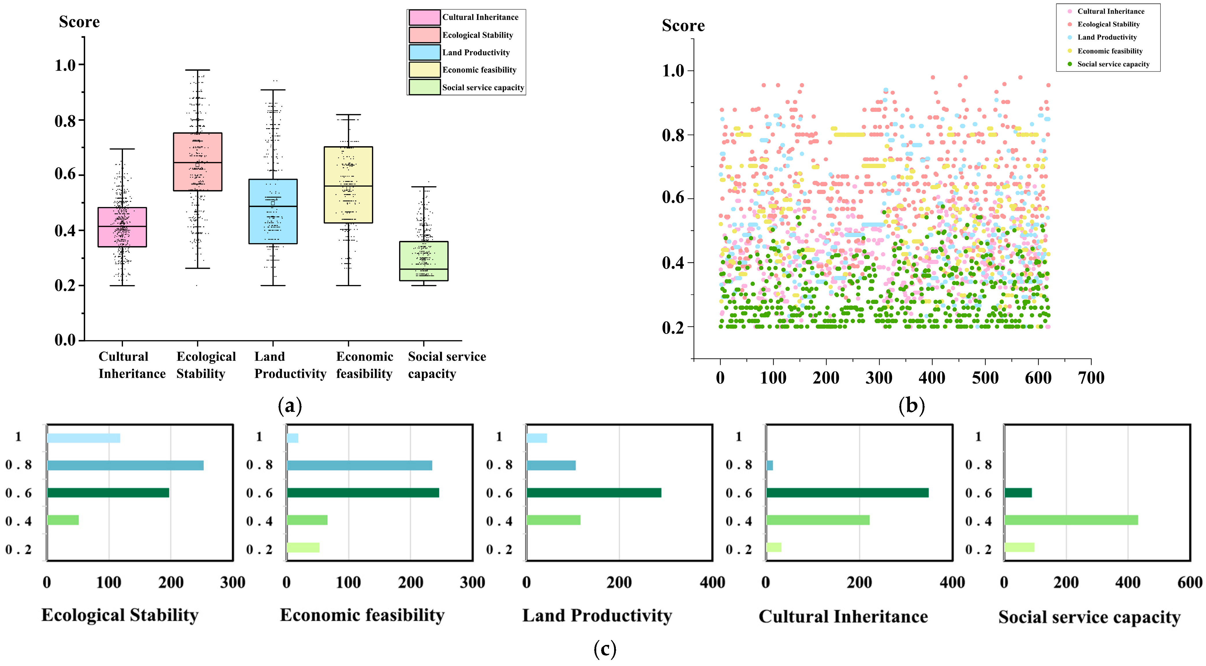
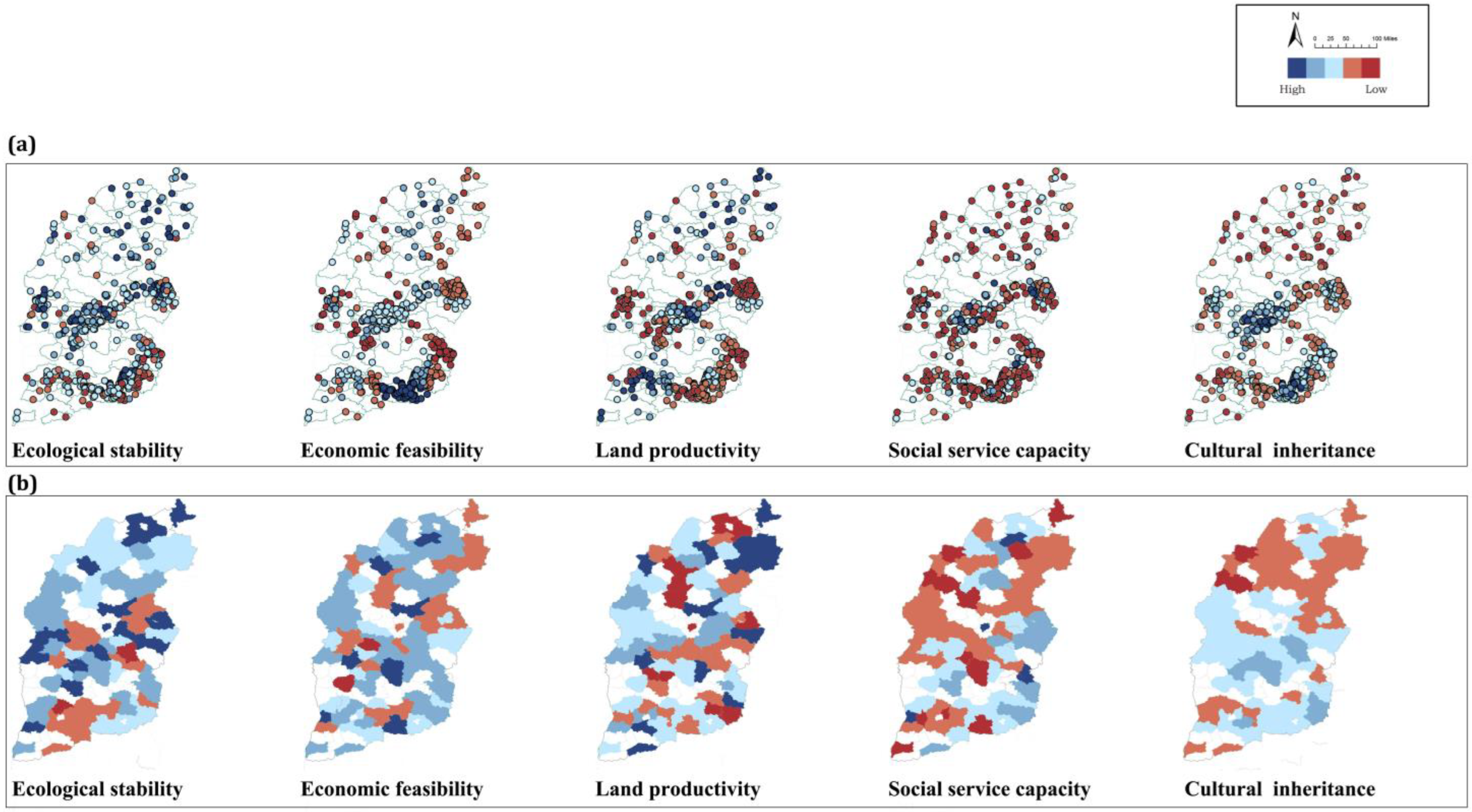
4.1. Statistical Results and Spatial Characterization

Figure 4 shows the scores of the current livelihood assets of traditional villages. Overall, the sample of 619 National Traditional Villages in Shanxi Province varied widely in the scores of the five dimensions. On the whole, the social assets held by the vast majority of traditional villages are not optimistic.
The overall scores were, in descending order, ecological stability, economic feasibility, land productivity, cultural inheritance, and social service capacity. As shown in Figure 4c, the ecological score of traditional villages was the highest, with an average score of 0.64, and 59.9 percent of the total number of villages scored better; 41 percent of the total number of villages scored better than the economic score; and most villages scored ‘average’ on the food productivity indicator, with 46 percent. The average score for cultural heritage indicators was lower, with 46.5 percent of villages scoring ‘poor’ or ‘bad’, indicating that the overall state of conservation of cultural heritage resources was not good. The level of social service performed the worst, with an average score of 0.29, and 85.6 percent of the total number of villages scored ‘poor’ or ‘bad’.
Figure 5a,b shows the characteristics of the spatial distribution of the different livelihood assets at the village and county scales, respectively. From the overall results, the spatial distribution of the low-scoring band was tilted from the northwest region toward the two southern regions, the southeast and southwest. Meanwhile, the score results of single indicators were spatially heterogeneous. High-scoring regions with better ecological resources were mainly concentrated in the belt basin in the center, the Changzhi Basin in the southeast region, and the hilly areas on the western edge. The regions with high economic scores were distributed in multiple clusters around the urban areas of various economic centers from north to south in Shanxi Province, such as Datong in the north, Taigu, Qixian, and Pingyao in the central region, and Changzhi in the south. The areas with high scores in land productivity indicators were spatially dispersed, surrounding the basin in the province’s center in a U-shaped pattern. High-scoring cultural areas were patchy and concentrated in the southeastern region, where many traditional village clusters are gathered. The high scores were mainly focused around Jincheng, Shangdang, and Lucheng, in the basins of Jincheng and Shangdang, which rely on the Qin River and surround the Taihang and Taiyue mountains. Regarding the social service indicator scores, most other regions had low scores, except for the Datong, Taiyuan, Jincheng, and Yuncheng regions, which were point regions with an excellent social service base.

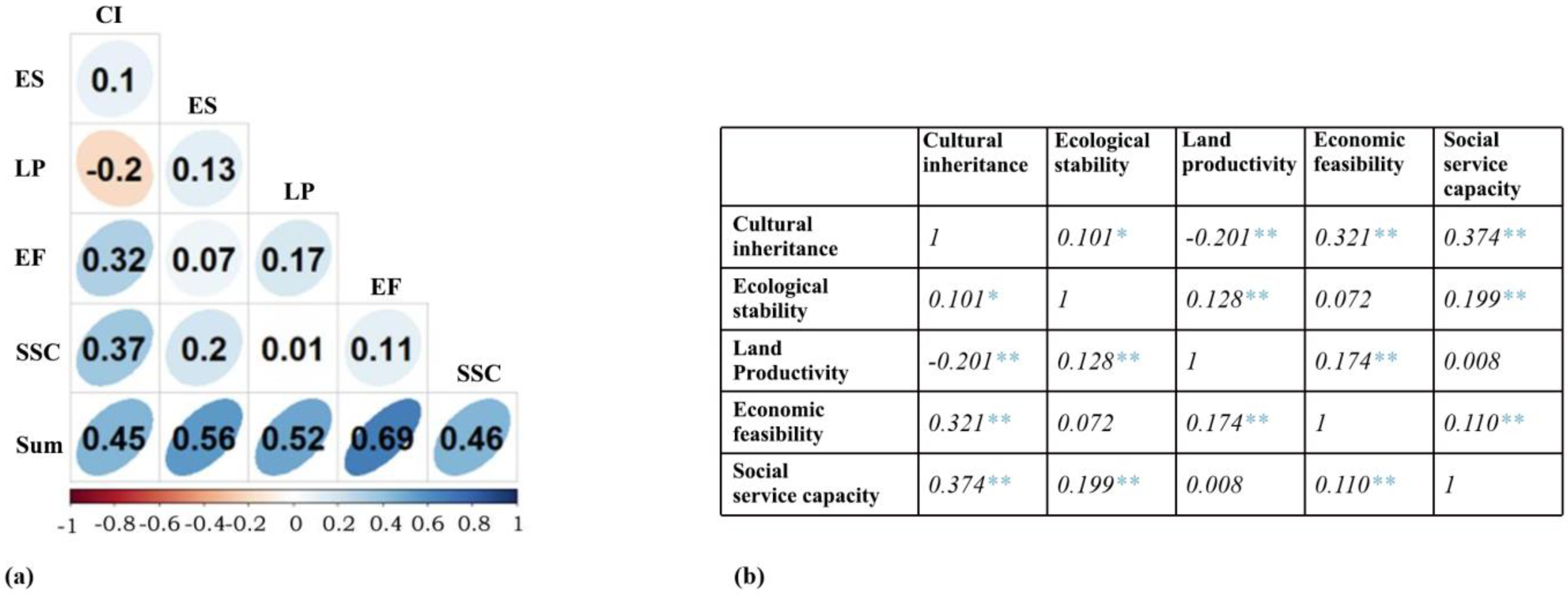
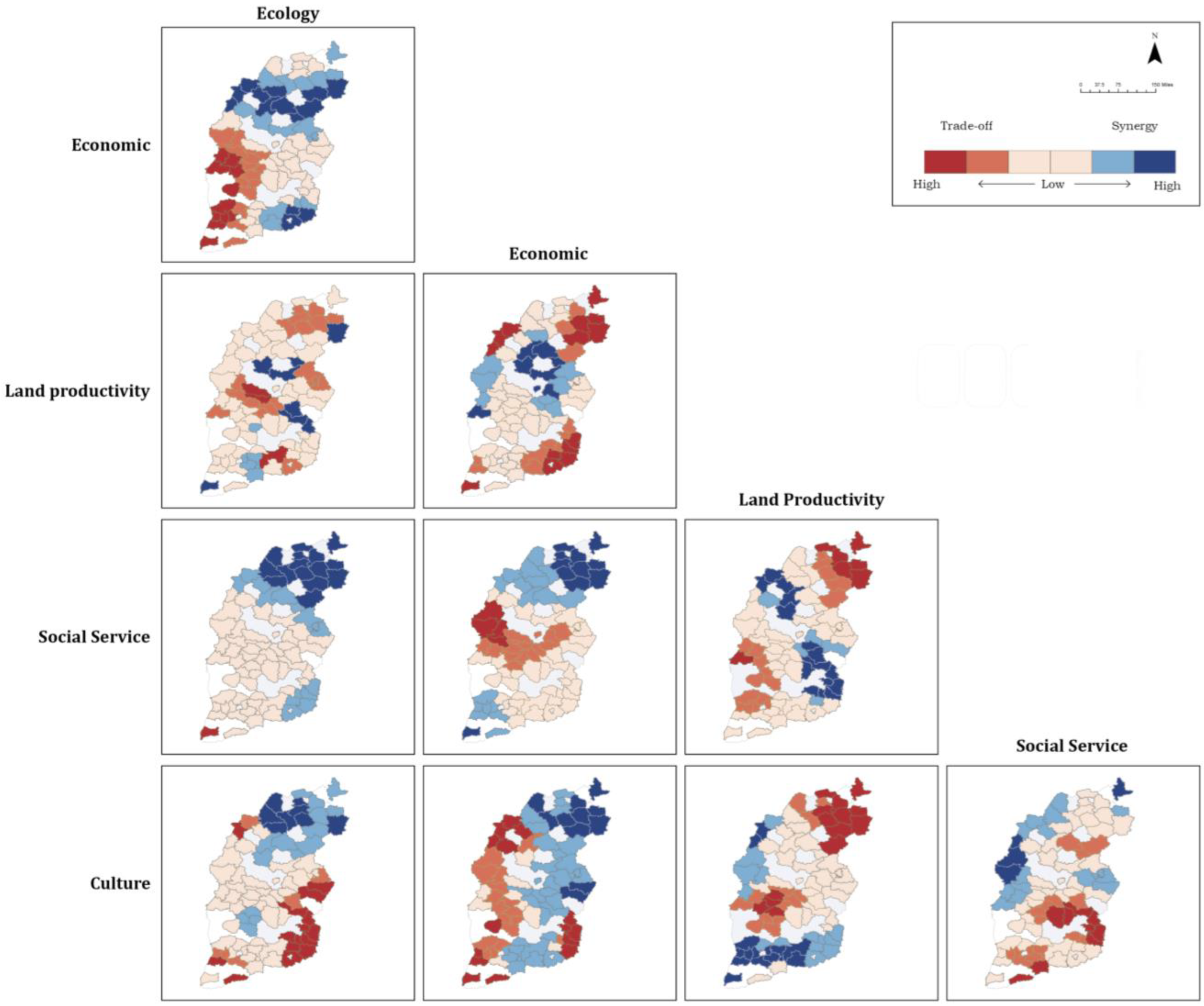
4.2. Trade-Offs and Synergies

Figure 6a reveals the results of the Pearson correlation analysis at the village scale, further demonstrating the strong relationship between the dimensions. Figure 6b demonstrates the numerical results of the Pearson correlation analysis conducted using SPSS software (IBM SPSS Statistics 27.0.1), further validating the accuracy of the model.
The outcomes of the correlation analysis underscored the significance and utility of cultural capital within the livelihood assets of traditional villages. The results reveal a positive contribution of cultural capital to both economic and social assets, indicating that the judicious preservation of local cultures can foster sustainability on both economic and social fronts. This phenomenon particularly manifests in the context of Pingyao village. Cultural capital has emerged as a crucial livelihood asset for the villagers. The village’s extensive history, distinctive customs, meticulously preserved built environment, and unique location and layout—distinguishing it from other villages—have collectively transformed Pingyao into a tourist destination. Rural tourism has effectively harnessed Pingyao’s cultural capital, translating it into substantial economic gains. This has empowered local residents to sustain their livelihoods through active participation in tourism-related activities, similar to the rural tourism development in many other areas [58,59]. Furthermore, the gradual accumulation of these economic and social assets has deepened the villagers’ comprehension and sense of identity regarding the value and essence of their local culture. This, in turn, has enriched their cultural cognition and value understanding, creating a feedback loop that reinforces the importance of cultural capital in their lives.
Concurrently, a notable trade-off is observed between cultural capacity and land productivity, particularly in villages that are abundant in cultural heritage and have been transformed by the tourism sector. In these villages, traditional agriculture has become a small part of their livelihood, and land is being used for new construction. To mitigate these trade-offs and ensure the sustainability of these villages, it is imperative to establish a long-term management mechanism and exercise rational control over land resources. Through comprehensive policy measures, a more balanced relationship between cultural assets and land resources can be achieved, thereby fostering the holistic and coordinated development of the villages. In this regard, no significant trade-offs or synergistic relationships were observed between the remaining indicator pairs.
The GWR model results revealed that the spatial trade-offs and synergies of indicator pairs were spatially heterogeneous at spatial scales (Figure 7). The statistical results demonstrated that the proportion of the spatial synergies was higher than the proportion of spatial trade-offs for most indicator pairs, indicating that spatial synergies dominated these. Then, the spatial trade-off ratios of the land productivity–social service level, land productivity–ecological stability, and economic feasibility–social service level pairs were higher than the spatial synergy ratios. Overall, in terms of spatial distribution, the spatial trade-offs were higher in areas located in the periphery, mainly in the Lvliang mountainous region and the north plain region. In contrast, the spatial synergies were higher in the central region, mainly in the central basin region.
Upon thorough examination of the correlation results, this analysis proceeds to investigate the characteristics of trade-offs and synergies in their spatial distribution. The findings reveal a distinct spatial pattern where cultural and economic synergy exhibits a notable “higher in the east, lower in the west, higher in the center, and lower around the periphery” distribution. The potential explanations for this spatial characteristic are as follows: Compared to the western regions, the eastern areas boast a more advanced level of economic development and a more mature cultural industry. This results in stronger cultural and economic synergy in the east, manifesting as a higher spatial correlation. Additionally, the effect of urban agglomeration is pronounced in the central regions. Large cities and urban clusters, with their superior capacity for resource concentration, provide an excellent platform for the interaction between the cultural industry and economic development [60]. The surrounding areas benefit from the radiating influence of these urban centers, leading to a relatively higher level of cultural and economic synergy. In contrast, the western and peripheral regions, which lag in economic development, face deficiencies in resource allocation and industrial development, resulting in a lower level of synergy between culture and the economy.
In particular, the southeastern part of Shanxi Province exhibits a favorable synergy between cultural and land resources. This phenomenon suggests that the region’s abundant agricultural land resources have provided a solid foundation for the development of the cultural industry. The rational utilization and optimized allocation of land resources have not only promoted the development of agriculture-related cultural industries but have also contributed to new growth points for the regional economy. This synergy offers valuable insights for optimizing resource allocation and promoting coordinated regional development. However, other areas in Shanxi Province demonstrate weaker synergy between cultural and land resources and even exhibit trade-off characteristics. This may imply that these regions confront the dilemma between resource exploitation and conservation in the development of cultural industries. It is imperative for these areas to seek a more balanced and sustainable development path in future endeavors, ensuring the harmonious coexistence of cultural industry development and resource protection.

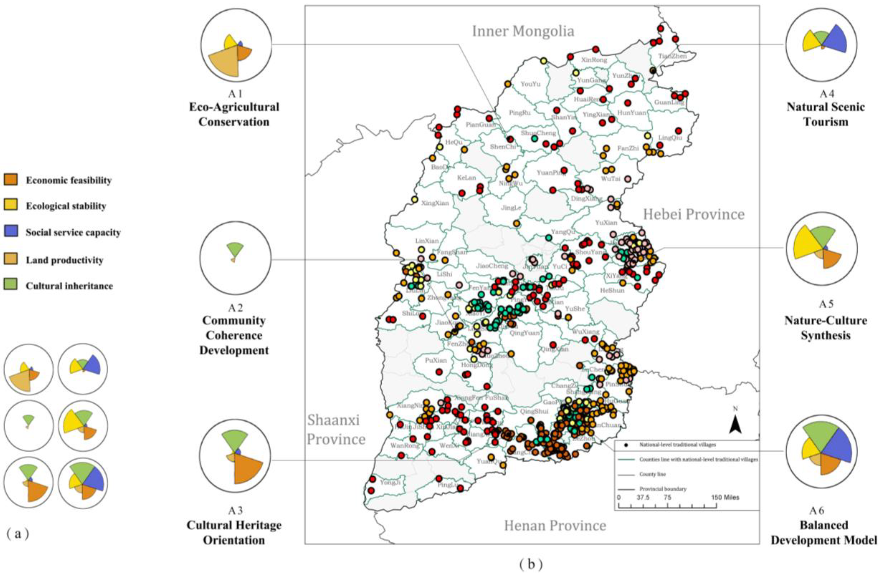
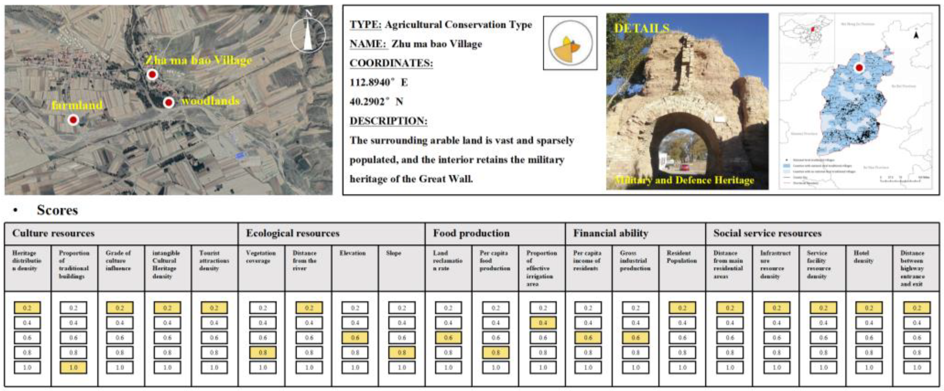
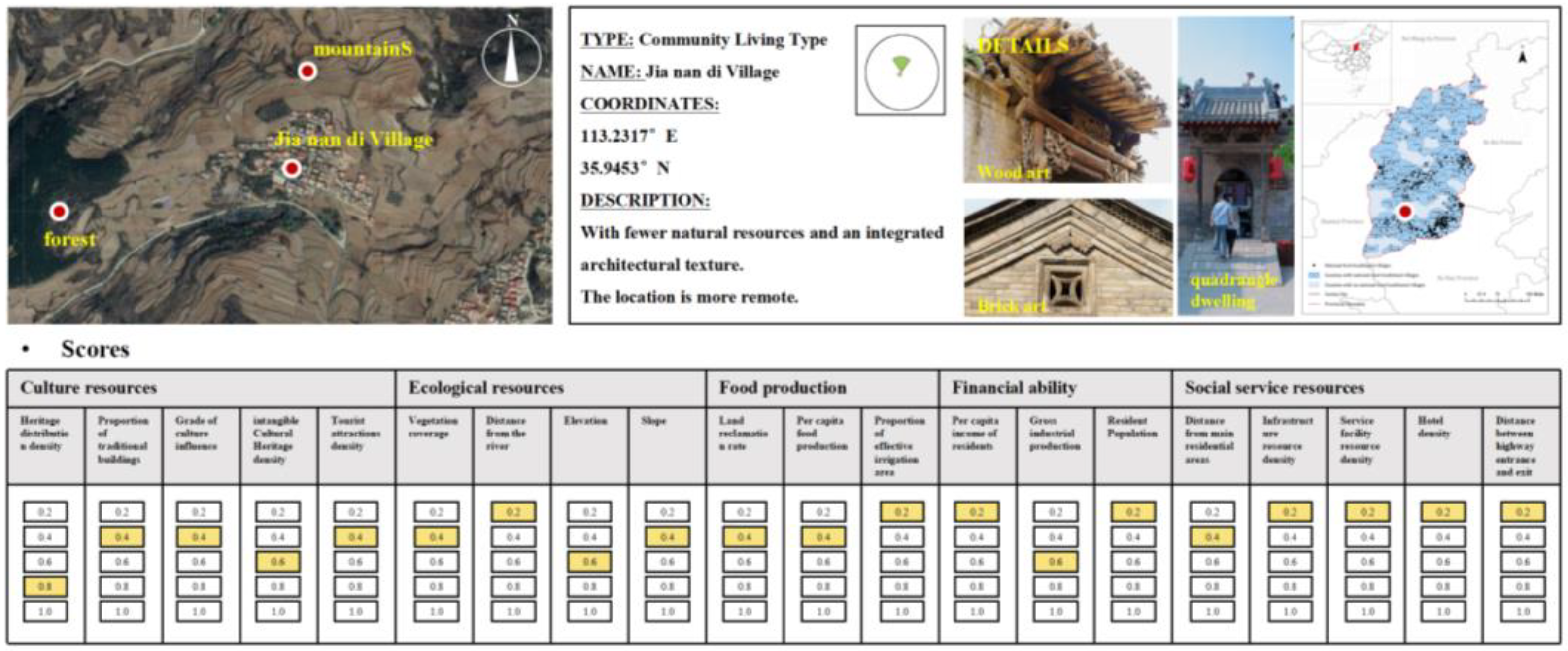
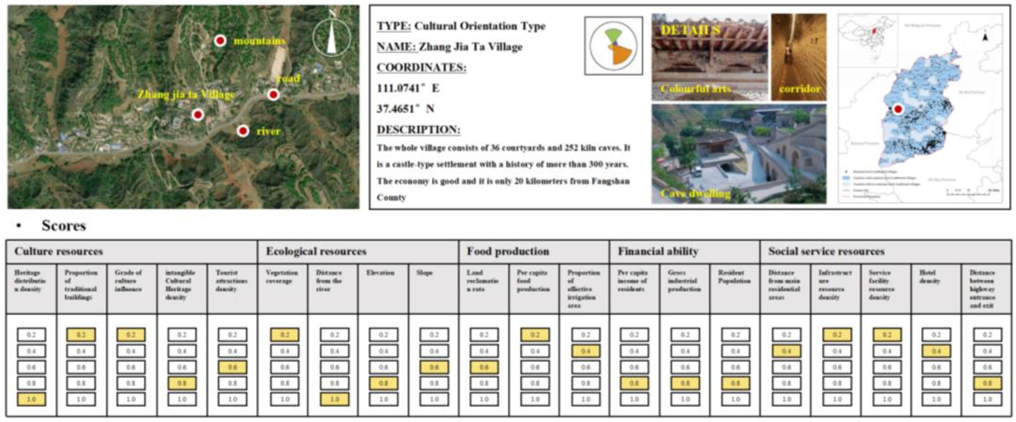
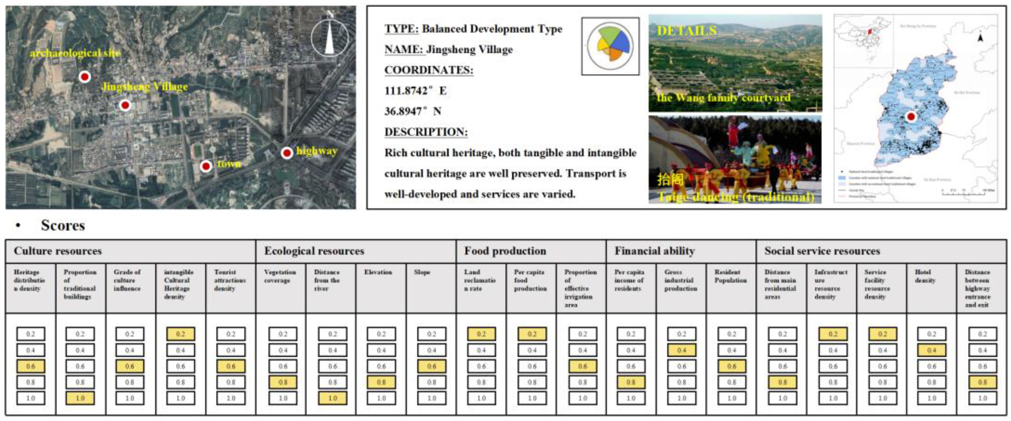
4.3. Identification Results of Village Livelihood Types

Through iterative refinement and enhancement of the SOM model, we carefully considered the differences between livelihood types (to ensure easy identification) and finally achieved the goal of classifying 619 villages into 6 different types (Figure 8). These included Eco-Agricultural Conservation (A1), Community Coherence Development (A2), Cultural Heritage Orientation (A3), Natural Scenic Tourism (A4), Nature–Culture Synthesis (A5), and a Balanced Development Model (A6). The outcomes of this classification vividly illustrated the existing livelihood structures within villages, facilitating the integration of internal assets for future development and the formulation of sustainable livelihood strategies with distinctive characteristics. Moreover, we endeavored to concatenate case studies with field research, convening a working group comprising experts and community members to profoundly identify and delineate the livelihood traits of the villages (Figure 8). Furthermore, we conducted on-site visits to select cases for the purpose of assessing the accuracy of the clustering validity checks. This step was essential to ensuring that the clustering outcomes genuinely reflect the actual distinctions in the characteristics of traditional villages. The validation results confirm that the classification produced is indeed authentic and valid [61].
A total of 133 villages (21.5% of the total) were classified as Eco-Agricultural Conservation (A1). These villages are generally located within vast agricultural areas and their economic structure is largely dependent on traditional agricultural production activities, which form their core economic backbone and source of income. Especially in terms of food production, these villages show significant comparative advantages, with Zhumabao Village (Figure 9) being a case in point. For these agriculture-based villages, future development plans should clearly point to a sustainable path for agriculture. Specifically, this involves the scientific planning and layout of farmland to improve the productive efficiency of the land. In the practice of agricultural management, the crop rotation system and crop layout scheme should be tailored according to the soil test results of each village and the crop growth records over the years. At the same time, regarding the improvement of the ecological environment, we propose carrying out systematic ecological restoration of farmland, forests, and lakes, which will help enhance the self-recovery ability and stability of the ecosystem.
In total, 121 (19.5%) villages were classified as Community Coherence Development (A2). These villages exhibit a more complete and stable village structure, rich cultural heritage, and high integrity in the community environment and historic architecture, but they face disadvantages in other assets. For instance, Jianandi Village (Figure 10) exemplifies this type with its typical mountainous landscape, hilly terrain, and limited farmland. The village’s fabric is well-preserved. In such villages, we aim to actively foster community leadership and residents’ self-governance capabilities, enhancing their participation in community governance through education and workshops. Simultaneously, we emphasize the sharing of village resources: optimizing public spaces to provide ample room for community activities; maintaining and improving community facilities to meet diverse resident needs; and ensuring equal access to public spaces, facilities, and services so that all residents benefit equally.
In total, 118 (19.1%) villages were classified as Cultural Heritage Orientation (A3). These villages showed development advantages in the cultural and economic dimensions and are suitable for humanistic-themed tourism development. Taking Zhangjiata as an example (Figure 11), Zhangjiata Village is located in Fangshan County, Luliang Mountainous Region, Shanxi Province, and the whole village is built on a mountainous terrain, forming a unique mountainous settlement. Inside the village is a castle-type complex with over 300 years of history, consisting of 36 courtyards and 252 holes of kiln caves. It was rated as a National Traditional Village in 2016. It is also economically strong due to the cultivation of coal mining. In the future, we should integrate cultural heritage protection into constructing tourism service facilities. This can include developing the unused kiln cave complexes in the village into lodging houses and activity centers for villagers and tourists to promote the appropriate reuse of historical buildings and pay attention to the value and participation of the villagers in conserving their living environment. We aim to promote this community as the leading participant in the protection of cultural heritage to increase publicity and enhance the cultural influence of the villages.
Sixty-two (10%) villages were classified as Natural Scenic Tourism (A4). The aim is to use the unique natural landscape resources, such as mountains, rivers, forests, and lakes, to develop tourism. These villages show the rich diversity of the natural landscape to a large extent and can provide excellent viewing and leisure experiences for visitors. In the future, it is necessary to further create eco-friendly tourism, and we encourage such villages to invest in the construction of infrastructure such as observation decks, walking trails, and campgrounds to improve the quality of tourists’ visits. While promoting tourism, it is necessary to pay attention to ecological protection, for example, through careful planning to identify the areas that can be developed and the areas that need to be strictly protected to ensure that the impact of tourism activities on the natural environment is minimized.
Eighty (12.9%) villages were categorized as Nature–Culture Synthesis (A5). These villages have rich natural economic resources and cultural heritage resources, such as Xi wan Village in the Luliang Mountainous Region in the western part of Shanxi Province, where natural resources such as mountains, forests, and ores are superior, with a high proportion of forest and grassland. In contrast, the village residential texture is well-preserved and distinctive so that, while developing eco-tourism based on the landscape and idyllic scenery, the mountainous eco-landscape sightseeing and tourism routes can be appropriately designed to include the six surrounding traditional villages of the same type (Gengshang et al.) in one of the sightseeing countryside clusters.
Furthermore. 105 (16.9%) villages were categorized as a Balanced Development Model (A6), which showed good development advantages in all five dimensions, with cultural and social service capabilities being the most prominent, making them suitable for establishing rural tourism clusters. Most of these villages are close to the central urban area, with high urban–rural integration, well-developed facilities, and mature tourism products with high development potential. Jing Sheng Village (Figure 12), for example, is located in the northeastern part of Lingshi County, Jinzhong City, Shanxi Province, and is one of the best-preserved Ming and Qing dynasty rural villages in China. In addition, it has an intangible cultural heritage—a traditional dance called ‘Tai Ge’. However, regarding the level of social services alone, the configuration of infrastructure and service facilities is still insufficient. In the future, it will be possible to cooperate with the neighboring villages, including Zhangbi, Liang, Beiguang, and Duanjia villages, to create a tourist circle, which will lead to the development of the area in a coherent manner and the synergistic development of the wider region. At the same time, the separation of residence and tourism is the key point of the strategy to prevent the destruction of the original villages by overloading tourists. In addition, a monitoring system should be promptly established to assess the impact of tourism development on cultural heritage regularly and to adjust protection and development measures according to the assessment results.

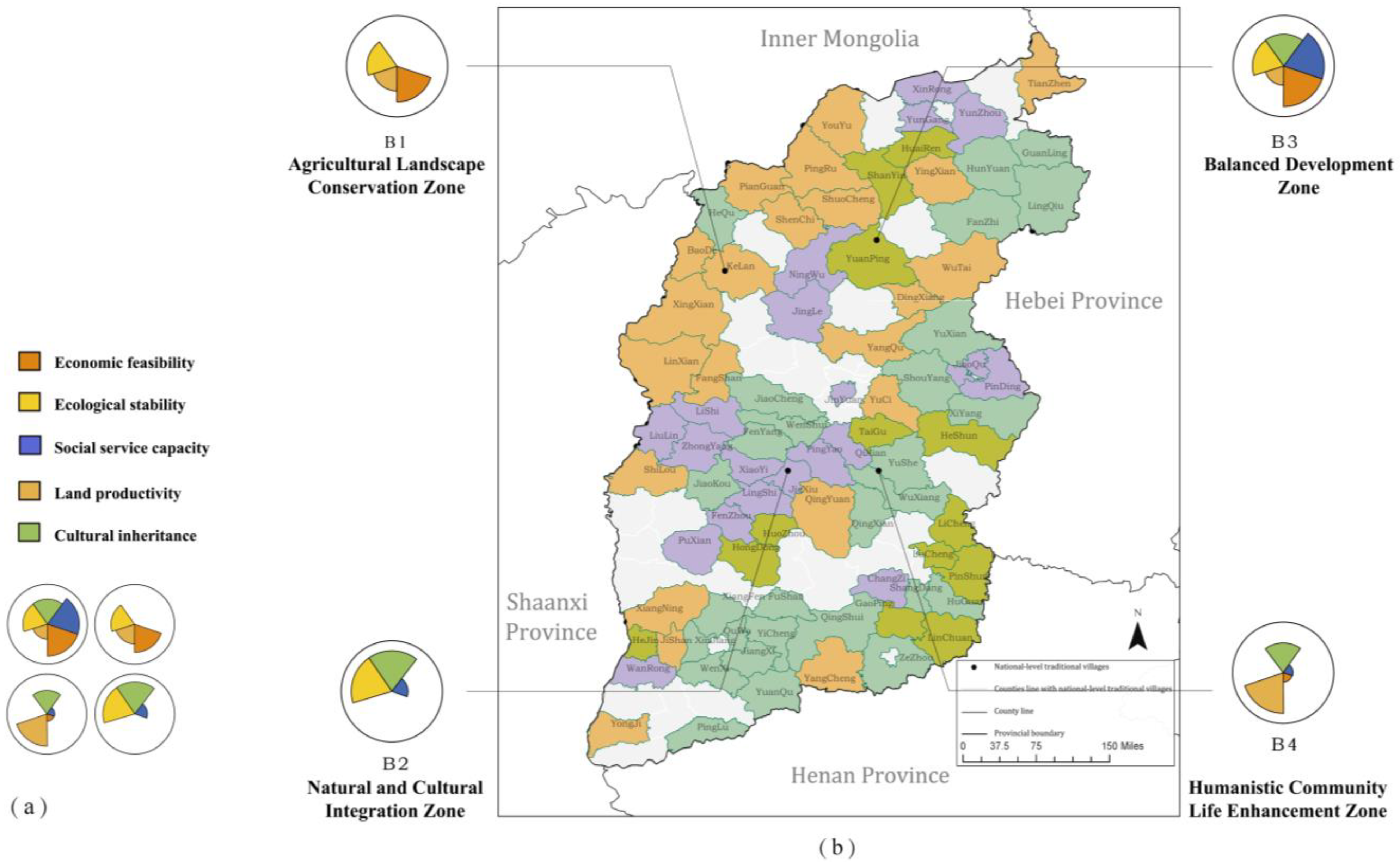
4.4. Revitalization Policy for “Multi-Livelihoods Zoning”

As widely recognized, county-level governance plays a pivotal role in China’s rural revitalization [62]. By establishing a regional development framework and contiguous-area protection policies, we enable differentiated yet coordinated growth while reducing homogeneous resource competition among villages [5]. Our approach integrates county-scale zoning with village-specific drivers to implement tiered policies Consequently, we propose a “multi-livelihood zoning” planning strategy as a comprehensive approach to the rural revitalization of Shanxi Province (Figure 13).
In Shanxi Province’s northwestern and central regions (e.g., Wutai and Yangqu counties), designated as Agricultural Landscape Conservation Zones (B1), development prioritizes preserving agricultural landscapes through balanced agricultural intensification/extensification and establishing ecological shelter belts to enhance environmental resilience. However, the vast, sparsely distributed villages result in fragmented cultural heritage distribution, hindering resource clustering. To address this, we recommend a cross-county cultural heritage alliance to integrate resources, coordinate surveys, and digital archiving [63].
The central Shanxi regions (Jiexiu, Liulin, and Pingyao) and northern Yungang are designated as Natural and Cultural Integration Zones (B2), prioritizing ecological and cultural synergies. This area promotes the integration of natural landscapes, historical sites, and traditional crafts to create unique tourism destinations. Key policy measures include allocating a portion of tourism revenue to heritage protection, implementing tax breaks and grants to engage local residents and businesses in heritage management, delineating strict boundaries between conservation areas and human activity zones to limit resource exploitation, and mandating environmental impact assessments to prevent tourism-driven harm to heritage and ecosystems.
A few regions belong to the Balanced Development Zone (B3). This part of the region has good multi-dimensional synergistic development capacity. It has the conditions necessary to radiate resources to neighboring regions and drive neighboring regions’ common development while maintaining the development status quo. In the future, it will be possible to formulate a centralized sustainable tourism ‘joint ticket’ policy so that supporting facilities and related industries can complement each other and the carrying capacity of the regional resources and environment can be assessed regularly.
The eastern and southern regions, categorized as the Humanistic Community Life Enhancement Zone (B4), leverage their strengths in traditional agriculture and cultural heritage through a multi-pronged strategy: developing agricultural specialty industries (e.g., processing bases), optimizing spatial layouts to establish cultural museums and village heritage platforms, conducting cultural relic surveys paired with digital dissemination for public education, and fostering community-driven decision-making to align heritage preservation with local interests—culminating in a holistic framework that cultivates community ownership and sustainable cultural stewardship.

5. Discussion

5.1. Obstacles to Revitalizing Traditional Villages in Shanxi

We revised and developed a village sustainable livelihood framework based on SDGs, aiming to study the current situation of livelihood assets in traditional villages in Shanxi Province. By analyzing the interaction mechanisms between these assets, we finally identified six sustainable livelihood strategies among traditional villages. The study revealed that many sampled villages lack adequate government and social service support due to policy biases favoring economically developed regions and key projects, coupled with geographical remoteness and underdeveloped infrastructure, which collectively increase the challenges and costs of resource allocation.
At the same time, the protection of cultural heritage in many villages is worrying. The cultural heritage of some villages has not been well used, while in some areas, cultural heritage is facing the risk of infringement due to the development trend of tourism. Meanwhile, the synergy between different assets only shows a better effect in some areas. From the overall situation of Shanxi Province, there is still much room for improvement in asset structure transformation.

5.2. Strengths of Livelihood Diversification in Rural Revitalization

Livelihood diversification refers to sustaining diverse livelihood activities to ensure survival, which is also a defining characteristic of sustainable livelihood strategies. Livelihood diversification can help traditional villages provide diversified ways to respond to economic and environmental uncertainties, increase economic resilience, reduce dependence on single activities, and enhance the resilience of villages [64]. It breaks through the excessive attention on single capital (such as spatial quality [65] or social networks [66]) in most revitalization strategy studies.
Meanwhile, livelihood diversification helps to balance the short-term and long-term goals. Through multi-level planning, the regional strategy is combined with targeted interventions, and multi-department cooperation is combined to promote the coordinated development of agricultural production, ecological landscape, characteristic cultural industries, and community cohesion and improve the utilization efficiency of resources in various dimensions.

5.3. Policy Suggestions

5.3.1. Enhancing Social Services

Enhancing the level of social services should be a priority for future optimization. Specifically, we propose that for traditional villages with poor overall livelihood assets, a strategy of shared infrastructure should be implemented [65,67]. The promotion of inter-regional cooperative management of cultural heritage, such as regional tourism cooperation mechanisms, has begun in some regions [68,69]. This entails cross-village cooperation to share infrastructure and service resources, thereby improving resource utilization efficiency and reducing the service cost provision, effectively alleviating the support burden on the government and social service networks.
For villages with sufficient social assets, it is suggested to develop tourism infrastructure, such as building an integrated system integrating housing, healthcare, and tourist service systems, to achieve economic diversification. In villages with concentrated tourism development, dynamic zoning policies need to be adopted, such as separating tourist areas and residential areas through transportation planning and taking measures to mitigate the impact of excessive tourism, such as traffic congestion, heritage destruction, and residential displacement. It is worth noting that the Cittaslow Movement provides villages with a management model that balances cultural protection, residents’ well-being, and tourist experiences under the guidance of community governance, which has important reference value [70].

5.3.2. Value the Synergies Between Different Assets

The synergistic relationship between cultural capital and economic society capital was noted in the results of this study and proved the feasibility in some villages. For example, in Qikou Village, Shanxi Province, traditional skills such as paper cutting and dough figurines have been embedded into the tourism industry chain to improve the average annual income of craftsmen among the villagers and optimize their age structure. Therefore, we believe that to promote this program, the government needs to develop more targeted policies to support the multi-dimensional transformation of cultural heritage, for example, the “Cultural Heritage Revitalization Fund” provides support, tax incentives, education and training programs, and so on.

5.4. Limitations and Future Work

Our study also has several limitations. The indicator we designed did not fully account for factors that are challenging to quantify yet essential to the sustainable development of traditional villages, such as local cultural identity and clan concepts that guide residents’ thoughts and behaviors. These elements may play a pivotal role in the long-term evolution of villages. Consequently, it is imperative to investigate methods to incorporate these factors into the evaluation framework, thereby providing a more comprehensive representation of the sustainability of traditional villages.

6. Conclusions

This study uses an improved sustainable livelihood framework (SLF) to assess livelihood assets and design strategies for 619 traditional villages in Shanxi Province, aiming to enhance livelihood diversity through multi-dimensional interventions. The findings reveal two key issues of traditional villages in Shanxi Province: (1) imbalanced asset structures, particularly the lack of social service facilities and poor coordination between land productivity and cultural inheritance; (2) significant spatial heterogeneity, with villages in different geographic locations showing varied resource endowments. Meanwhile, the synergy between cultural, economic, and social assets also shows that cultural assets can boost the village economy and strengthen community cohesion. Based on these findings, a dual-level governance approach is proposed: at the village level, tailored “one village, one policy” solutions are recommended to strengthen local adaptability; at the county level, a “multi-livelihoods zoning” management model is introduced to promote cross-village resource coordination. The results demonstrate that the improved SLF framework can effectively support policy-making under uncertain conditions, advancing ecological sustainability. Additionally, the village sustainability classification system and toolkit developed in this study offer valuable insights for rural revitalization in ecologically and culturally sensitive regions of central and western China. While the current framework emphasizes tangible assets, future iterations should integrate intangible social capital (e.g., clan networks and cultural identity) to better explain community cohesion dynamics. This refinement could strengthen the model’s explanatory power in diverse socio-cultural contexts.

Author Contributions

Conceptualization, Y.Z. and D.H.; Methodology, Y.Z.; Software, Y.Z.; Validation, Y.Z. and D.H.; Formal analysis, Y.Z.; Investigation, Y.Z.; Resources, D.H.; Data curation, Y.Z.; Writing—original draft preparation, Y.Z.; Writing—review and editing, D.H.; Visualization, Y.Z.; Supervision, D.H.; Project administration, D.H.; Funding acquisition, D.H. All authors have read and agreed to the published version of the manuscript.

Funding

This research was funded by the National Natural Science Foundation of China (Grant No. 52378002), the graduate innovation project of BUCEA (Grant No. PG2024002).

Data Availability Statement

The raw data supporting the conclusions of this article will be made available by the authors on request.

Acknowledgments

We are grateful to expert Huo Xiaowei, Vice president of Tsinghua Tongheng Architectural Design Institute, for their technical support, advice, and guidance during the fieldwork and village scoring experiments.

Conflicts of Interest

The authors declare that they have no known competing financial interests or personal relationships that could have appeared to influence the work reported in this paper.

References

  1. Prabowo, B.; Salaj, A. Identifying Overtourism Impacts on the Informal Sector’s Livelihoods in Urban Heritage Area. IOP Conf. Ser. Earth Environ. Sci. 2021, 738, 012044. [Google Scholar] [CrossRef]
  2. Wen, Q.; Li, J.; Ding, J.; Wang, J. Evolutionary process and mechanism of population hollowing out in rural villages in the farming-pastoral ecotone of Northern China: A case study of Yanchi County, Ningxia. Land Use Policy 2023, 125, 106506. [Google Scholar] [CrossRef]
  3. Wang, D.; Zhu, Y.; Zhao, M.; Lv, Q. Multi-dimensional hollowing characteristics of traditional villages and its influence mechanism based on the micro-scale: A case study of Dongcun Village in Suzhou, China. Land Use Policy 2021, 101, 105146. [Google Scholar] [CrossRef]
  4. Tu, S.; Long, H.; Zhang, Y.; Ge, D.; Qu, Y. Rural restructuring at village level under rapid urbanization in metropolitan suburbs of China and its implications for innovations in land use policy. Habitat Int. 2018, 77, 143–152. [Google Scholar] [CrossRef]
  5. Li, Y.; Long, H.; Liu, Y. Spatio-temporal pattern of China’s rural development: A rurality index perspective. J. Rural Stud. 2015, 38, 12–26. [Google Scholar] [CrossRef]
  6. United Nations. Transforming Our World: The 2030 Agenda for Sustainable Development; United Nations: New York, NY, USA, 2015. [Google Scholar]
  7. Barberà-Mariné, M.-G.; Fabregat-Aibar, L.; Ferreira, V.; Terceño, A. One Step Away from 2030: An Assessment of the Progress of Sustainable Development Goals (SDGs) in the European Union. Eur. J. Dev. Res. 2024, 36, 1372–1397. [Google Scholar] [CrossRef]
  8. Ma, X.; Wang, R.; Dai, M.; Yanghong, O. The influence of culture on the sustainable livelihoods of households in rural tourism destinations. J. Sustain. Tour. 2020, 29, 1235–1252. [Google Scholar] [CrossRef]
  9. McDonagh, J. Rural geography I: Changing expectations and contradictions in the rural. Prog. Hum. Geogr. 2013, 37, 712–720. [Google Scholar] [CrossRef]
  10. Pender, J. Population Growth, Agricultural Intensification, Induced Innovation and Natural Resource Sustainability: An Application of Neoclassical Growth Theory. Agric. Econ. 1998, 19, 99–112. [Google Scholar] [CrossRef]
  11. Ruben, R.; Pender, J. Rural diversity and heterogeneity in less-favoured areas: The quest for policy targeting. Food Policy 2004, 29, 303–320. [Google Scholar] [CrossRef]
  12. Madu, I.A. The structure and pattern of rurality in Nigeria. GeoJournal 2010, 75, 175–184. [Google Scholar] [CrossRef]
  13. Kroll, C.; Warchold, A.; Pradhan, P. Sustainable Development Goals (SDGs): Are we successful in turning trade-offs into synergies? Palgrave Commun. 2019, 5, 140. [Google Scholar] [CrossRef]
  14. Allen, C.; Metternicht, G.; Wiedmann, T. Prioritising SDG targets: Assessing baselines, gaps and interlinkages. Sustain. Sci. 2019, 14, 421–438. [Google Scholar] [CrossRef]
  15. Jia, Z.; Jiao, Y.; Zhang, W.; Chen, Z. Rural Tourism Competitiveness and Development Mode, a Case Study from Chinese Township Scale Using Integrated Multi-Source Data. Sustainability 2022, 14, 4147. [Google Scholar] [CrossRef]
  16. Dfid. Overview of the Key Sheets for Sustainable Livelihoods—Key Sheets for Sustainable Livelihoods; Department for International Development: London, UK, 1999. [Google Scholar]
  17. Solesbury, W. Sustainable Livelihoods: A Case Study of the Evolution of DFID Policy; Overseas Development Institute: London, UK, 2003; Volume 217. [Google Scholar] [CrossRef]
  18. Bebbington, A.J. Capitals and capabilities: A framework for analysing peasant viability, rural livelihoods and poverty in the Andes. World Dev. 1999, 27, 2021–2044. [Google Scholar] [CrossRef]
  19. Su, J. Intangible Cultural Heritage Safeguarding in the Context of Tourism: A Case Study of Lijiang, China. Ph.D. Thesis, Deakin University, Sydney, Australia, 2017. [Google Scholar]
  20. Scazzosi, L. Rural landscape as heritage: Reasons for and implications of principles concerning rural landscapes as heritage ICOMOS-IFLA 2017. Built Herit. 2018, 2, 39–52. [Google Scholar] [CrossRef]
  21. Yin, S. Study on the Protection and Development of Farming-Type Traditional Village Landscape Under the Concept of Sustainability–A Case Study of Western Henan. In Proceedings of the International Conference on Green Building, Civil Engineering and Smart City, Guilin, China, 8–10 April 2022; pp. 299–310. [Google Scholar]
  22. Qiao, W.; Hu, B.; Guo, Z.; Huang, X. Evaluating the sustainability of land use integrating SDGs and its driving factors: A case study of the Yangtze River Delta urban agglomeration, China. Cities 2023, 143, 104569. [Google Scholar] [CrossRef]
  23. Natarajan, N.; Newsham, A.; Rigg, J.; Suhardiman, D. A sustainable livelihoods framework for the 21st century. World Dev. 2022, 155, 105898. [Google Scholar] [CrossRef]
  24. Ison, R.L.; Ampt, P.R. Rapid rural appraisal: A participatory problem formulation method relevant to Australian agriculture. Agric. Syst. 1992, 38, 363–386. [Google Scholar] [CrossRef]
  25. Zhifei, L.; Qianru, C.; Hualin, X. Comprehensive Evaluation of Farm Household Livelihood Assets in a Western Mountainous Area of China: A Case Study in Zunyi City. J. Resour. Ecol. 2018, 9, 154–163. [Google Scholar] [CrossRef]
  26. Xiang, Q.; Yu, H.; Chu, H.; Hu, M.; Xu, T.; Ju, L.; Hu, W.; Huang, H. Integrating land use functions and heavy metal contamination to classify village types. Ecol. Indic. 2023, 154, 110786. [Google Scholar] [CrossRef]
  27. Paul, C.; Weinthal, E.; Bellemare, M.; Jeuland, M. Social capital, trust, and adaptation to climate change: Evidence from rural Ethiopia. Glob. Environ. Change 2016, 36, 124–138. [Google Scholar] [CrossRef]
  28. Saxena, A.; Güneralp, B.; Bailis, R.; Yohe, G.; Oliver, C. Evaluating the resilience of forest dependent communities in Central India by combining the sustainable livelihoods framework and the cross scale resilience analysis. Environ. Sci. Sociol. Curr. Sci. 2016, 110, 1195–1207. [Google Scholar]
  29. Pitaloka, A.; Abdurrahim, A. Sustainable Livelihoods Approach and Contemporary Research on Rural Social-Ecological Systems in Indonesia. IOP Conf. Ser. Earth Environ. Sci. 2023, 1275, 012044. [Google Scholar] [CrossRef]
  30. Gao, J.; Wu, B. Revitalizing traditional villages through rural tourism: A case study of Yuanjia Village, Shaanxi Province, China. Tour. Manag. 2017, 63, 223–233. [Google Scholar] [CrossRef]
  31. Tang, C.; Liu, Y.; Wan, Z.; Liang, W. Evaluation system and influencing paths for the integration of culture and tourism in traditional villages. J. Geogr. Sci. 2023, 33, 2489–2510. [Google Scholar] [CrossRef]
  32. Yanan, L.; Ismail, M.A.; Aminuddin, A. How has rural tourism influenced the sustainable development of traditional villages? A systematic literature review. Heliyon 2024, 10, e25627. [Google Scholar] [CrossRef]
  33. Chen, X.; Yin, Y.; Jiang, M.; Lin, H. Deep Analysis of the Homogenization Phenomenon of the Ancient Water Towns in Jiangnan: A Dual Perspective on Landscape Patterns and Tourism Destination Images. Sustainability 2023, 15, 12595. [Google Scholar] [CrossRef]
  34. Su, M.; Wall, G.; Wang, Y.; Jin, M. Livelihood sustainability in a rural tourism destination—Hetu Town, Anhui Province, China. Tour. Manag. 2019, 71, 272–281. [Google Scholar] [CrossRef]
  35. Xie, J.; Wu, X.; Tang, J.-J.; Zhang, J.-E.; Luo, S.-M.; Chen, X. Conservation of Traditional Rice Varieties in a Globally Important Agricultural Heritage System (GIAHS): Rice-Fish Co-Culture. Agric. Sci. China 2011, 10, 754–761. [Google Scholar] [CrossRef]
  36. Li, M.; Xu, S.; Tang, J.; Chen, W. Design and research of digital twin platform for handicraft intangible cultural heritage -Yangxin Cloth Paste. Herit. Sci. 2024, 12, 43. [Google Scholar] [CrossRef]
  37. King, B. Towards a Participatory GIS: Evaluating Case Studies of Participatory Rural Appraisal and GIS in the Developing World. Cartogr. Geogr. Inf. Sci. 2002, 29, 43–52. [Google Scholar] [CrossRef]
  38. Smiley, S.; Loë, R.; Kreutzwiser, R. Appropriate Public Involvement in Local Environmental Governance: A Framework and Case Study. Soc. Nat. Resour. 2010, 23, 1043–1059. [Google Scholar] [CrossRef]
  39. Al-Qubatee, W.; Ritzema, H.; Al-Weshali, A.; Steenbergen, F.; Hellegers, P. Participatory rural appraisal to assess groundwater resources in Al-Mujaylis, Tihama Coastal Plain, Yemen. In Groundwater; Routledge: London, UK, 2023; pp. 167–187. [Google Scholar]
  40. Türk, E. Multi-criteria Decision-Making for Greenways: The Case of Trabzon, Turkey. Plan. Pract. Res. 2017, 33, 326–343. [Google Scholar] [CrossRef]
  41. Saaty, T. Decision making—The Analytic Hierarchy and Network Processes (AHP/ANP). J. Syst. Syst. Eng. 2004, 13, 1–35. [Google Scholar] [CrossRef]
  42. Tan, G.; Zhu, J.; Chen, Z. Deep learning based identification and interpretability research of traditional village heritage value elements: A case study in Hubei Province. Herit. Sci. 2024, 12, 200. [Google Scholar] [CrossRef]
  43. Chen, Y.; Li, R. Spatial Distribution and Type Division of Traditional Villages in Zhejiang Province. Sustainability 2024, 16, 5262. [Google Scholar] [CrossRef]
  44. Chen, L.; Zhong, Q.; Li, Z. Analysis of spatial characteristics and influence mechanism of human settlement suitability in traditional villages based on multi-scale geographically weighted regression model: A case study of Hunan province. Ecol. Indic. 2023, 154, 110828. [Google Scholar] [CrossRef]
  45. Chen, M.; Chen, C.; Jin, C.; Li, B.; Zhang, Y.; Zhu, P. Evaluation and obstacle analysis of sustainable development in small towns based on multi-source big data: A case study of 782 top small towns in China. J. Environ. Manag. 2024, 366, 121847. [Google Scholar] [CrossRef]
  46. He, D.; Hu, J.; Zhang, J. Assessment of Sustainable Development Suitability in Linear Cultural Heritage—A Case of Beijing Great Wall Cultural Belt. Land 2023, 12, 1761. [Google Scholar] [CrossRef]
  47. Akuraju, V.; Pradhan, P.; Haase, D.; Kropp, J.P.; Rybski, D. Relating SDG11 indicators and urban scaling—An exploratory study. Sustain. Cities Soc. 2020, 52, 101853. [Google Scholar] [CrossRef]
  48. Pan, Y.; Zhao, X.; Zhang, Y.; Luo, H. A large-scale village classification model for tailored rural revitalization: A case study of Hubei province, China. J. Geogr. Sci. 2024, 34, 2364–2392. [Google Scholar] [CrossRef]
  49. Chitea, L.F. Typology of the romanian rural area based on the modernization and rural socio-economic development perspectives. Sci. Pap. Ser. Manag. Econ. Eng. Agric. Rural. Dev. 2022, 22, 99–106. [Google Scholar]
  50. Qiao, J.; Kong, Y.; Li, X. Analysis of types and changes of village-level economy in rural Gongyi city, Henan Province since 1990. 2008, 18, 101–108. [CrossRef]
  51. Zhang, Y.; Ji, X.; Sun, L.; Gong, Y. Spatial Evaluation of Villages and Towns Based on Multi-Source Data and Digital Technology: A Case Study of Suining County of Northern Jiangsu. Sustainability 2022, 14, 7603. [Google Scholar] [CrossRef]
  52. Massini, G. Visualization and clustering of self-organizing maps. In Intelligent Data Mining in Law Enforcement Analytics: New Neural Networks Applied to Real Problems; Springer: Berlin/Heidelberg, Germany, 2012; pp. 177–192. [Google Scholar]
  53. Kohonen, T. Essentials of the self-organizing map. Neural Netw. 2013, 37, 52–65. [Google Scholar] [CrossRef]
  54. Xia, H.; Yuan, S.; Prishchepov, A.V. Spatial-temporal heterogeneity of ecosystem service interactions and their social-ecological drivers: Implications for spatial planning and management. Resour. Conserv. Recycl. 2023, 189, 106767. [Google Scholar] [CrossRef]
  55. Stryhal, J.; Plavcová, E. On using self—Organizing maps and discretized Sammon maps to study links between atmospheric circulation and weather extremes. Int. J. Climatol. 2023, 43, 2678–2698. [Google Scholar] [CrossRef]
  56. Jiang, N.; Luo, K.; Beggs, P.; Cheung, K.; Scorgie, Y. Insights into the implementation of synoptic weather-type classification using self-organizing maps: An Australian case study. Int. J. Climatol. 2014, 35, 3471–3485. [Google Scholar] [CrossRef]
  57. Kim, T.-S.; Dhakal, T.; Kim, S.-H.; Lee, J.-H.; Kim, S.-J.; Jang, G.-S. Examining village characteristics for forest management using self- and geographic self-organizing maps: A case from the Baekdudaegan mountain range network in Korea. Ecol. Indic. 2023, 148, 110070. [Google Scholar] [CrossRef]
  58. Hall, C.; Mitchell, I.; Keelan, N. Maori Culture and Heritage Tourism in New Zealand. J. Cult. Geogr. 1992, 12, 115–128. [Google Scholar] [CrossRef]
  59. Mitchell, C.; Shannon, M. Exploring cultural heritage tourism in rural Newfoundland through the lens of the evolutionary economic geographer. J. Rural Stud. 2018, 59, 21–34. [Google Scholar] [CrossRef]
  60. Chu, M.; Lu, J.; Sun, D. Influence of Urban Agglomeration Expansion on Fragmentation of Green Space: A Case Study of Beijing-Tianjin-Hebei Urban Agglomeration. Land 2022, 11, 275. [Google Scholar] [CrossRef]
  61. Qin, X.; Yurui, L.; Lu, Z.; Pan, W. What makes better village economic development in traditional agricultural areas of China? Evidence from 338 villages. Habitat Int. 2020, 106, 102286. [Google Scholar] [CrossRef]
  62. Yu, Z.; Yuan, D.; Zhao, P.; Lyu, D.; Zhao, Z. The role of small towns in rural villagers’ use of public services in China: Evidence from a national-level survey. J. Rural Stud. 2023, 100, 103011. [Google Scholar] [CrossRef]
  63. Zhang, Y.; Ikiz Kaya, D.; van Wesemael, P.; Colenbrander, B.J. Youth participation in cultural heritage management: A conceptual framework. Int. J. Herit. Stud. 2023, 30, 56–80. [Google Scholar]
  64. Fan, J.; Mo, Y.; Cai, Y.; Zhao, Y.; Su, D. Evaluation of Community Resilience in Rural China—Taking Licheng Subdistrict, Guangzhou as an Example. Int. J. Environ. Res. Public Health 2021, 18, 5827. [Google Scholar] [CrossRef]
  65. Zhang, J.; Zhang, R.; Li, Q.; Zhang, X.; He, X. Spatial Sifferentiation and Differentiated Development Paths of Traditional Villages in Yunnan Province. Land 2023, 12, 1663. [Google Scholar] [CrossRef]
  66. Sun, C.; Lee, I. Cognitive Recognition of Space and Social Connections of Traditional Villages in Shanxi Province: A Case Study of Ding, Shijiagou, and Yanjing Villages. Sustainability 2024, 16, 9695. [Google Scholar] [CrossRef]
  67. Liu, X.; Yuan, L.; Tan, G. Identification and Hierarchy of Traditional Village Characteristics Based on Concentrated Contiguous Development—Taking 206 Traditional Villages in Hubei Province as an Example. Land 2023, 12, 471. [Google Scholar] [CrossRef]
  68. Wang, Y.; Xi, M.; Wu, X. A social network analysis of tourism cooperation in the Yangtze River Delta: A supply and demand perspective. PLoS ONE 2022, 17, e0263411. [Google Scholar] [CrossRef]
  69. Ekinci, M.B. The Cittaslow philosophy in the context of sustainable tourism development; the case of Turkey. Tour. Manag. 2014, 41, 178–189. [Google Scholar] [CrossRef]
  70. Park, E.; Kim, S. The potential of Cittaslow for sustainable tourism development: Enhancing local community’s empowerment. Tour. Plan. Dev. 2016, 13, 351–369. [Google Scholar] [CrossRef]
Figure 1. The DFlD sustainable livelihoods framework (SLF) (Source: redrawn from DFlD 1999).
Buildings 15 01127 g001
Figure 2. Location of study area and sampling sites. Note: We focused on counties with National Traditional Villages from the first six batches, excluding others as irrelevant to the study. Data for village points were obtained from the National Earth System Science Data Center.
Buildings 15 01127 g002
Figure 3. Indicators of livelihood assets of traditional villages oriented to SDGs.
Buildings 15 01127 g003
Figure 4. (a) Box plot of village scores on five livelihood assets; (b) scatter plot of village scores on five livelihood assets; (c) score level and number of villages for each asset. Note: The analysis reveals that the social assets in most traditional villages remain sub-optimal.
Buildings 15 01127 g004
Figure 5. (a) Village-scale spatial distribution of scores on the five livelihood assets; (b) county-scale spatial distribution of scores on the five livelihood assets. Note: From the overall results, there is a spatial heterogeneity in the asset distribution in traditional villages. The spatial distribution of the low-scoring band was tilted from the northwest region towards the two southern regions, the southeast and southwest.
Buildings 15 01127 g005
Figure 6. (a) Pearson’s correlation results; (b) SPSS-validated Pearson correlation results. Note: * p < 0.05 indicates a significant correlation; ** p < 0.01 indicates a highly significant correlation. The outcomes of the correlation analysis underscored the significance and utility of cultural capital within the livelihood assets of traditional villages.
Buildings 15 01127 g006
Figure 7. Spatial synergies and trade-offs of ten indicator pairs. Note: The synergy in the central area is generally higher than that in other surrounding areas.
Buildings 15 01127 g007
Figure 8. (a) Livelihood capital types and resulting strategies (b) Spatially distributed characteristics of each livelihood strategy Note: The livelihood diversification results in this village address the ’one size fits all’ dilemma by keeping the intervention with the asset endowment of village size, providing a replicable approach for other regions.
Buildings 15 01127 g008
Figure 9. Archives of Zhumabao Village. Note: Zhumabao Village, located along the Ming Great Wall. Its land use characteristics mainly manifest as an interwoven area of agriculture, animal husbandry, and forests, forming a unique agricultural ecological landscape. However, the problem of soil and water loss is not a small hidden danger, which poses a severe challenge to the protection of agricultural ecology and the maintenance of ecological landscape of the Great Wall belt. As a traditional village recognized by the state, Zhumabao village has important cultural heritage value but its population is aging, with only about 100 people. Determining how to protect traditional culture and ecological environment while revitalizing the village is the most important strategic issue for the village at present.
Buildings 15 01127 g009
Figure 10. Archives of Jianandi Village. Note: Jianandi Village is 40 km from Changzhi, Shanxi Province. Its total household population is less than 500, and its resident population is less than 200. The village’s traditional architecture is small and exquisite, with the traditional courtyard house of human habitation as the main feature. In 2023, the village was selected as one of the villages in the sixth batch of Chinese traditional villages.
Buildings 15 01127 g010
Figure 11. Archives of Zhangjiata Village. Note: Zhangjiata Village is a typical castle-type village left over from the Ming and Qing dynasties. Its rich cultural uniqueness includes alleys, cave dwellings, architectural decorations such as brick and wood carvings, and water infrastructure. The village is rich in historical style elements, and at the same time, it has a complete underground walking system, the Yongdao, with a total length of more than 2200 m. The village is small, with a permanent population of 200–500 people. In 2016, the village was selected as one of the villages in the fourth batch of Chinese traditional villages.
Buildings 15 01127 g011
Figure 12. Archives of Jingsheng Village. Note: Jingsheng Village was selected as one of the second batch of Chinese traditional villages in 2013. More than 30 national critical cultural relic protection units are listed in the village, and many folk documents such as inscriptions, genealogies, and documents remain. The most famous Wang Grand Courtyard, located in the center of the village, is a 4A-level tourist attraction and is known as the ‘Forbidden City of Chinese Folk’. Meanwhile, the village is 12 km from Lingshi County in Jinzhong and 2.5 km from the high-speed railway station. Due to its rich cultural tourism resources and convenient traffic conditions, the village’s primary industry has changed from traditional agriculture to tourism.
Buildings 15 01127 g012
Figure 13. (a) Livelihood capital types and resulting strategies (b) The “multi-livelihoods zoning” strategy. Note: The regional-level livelihood diversification outcomes establish a cross-scale governance framework by integrating cross-village resource policies with macro-geographical zoning.
Buildings 15 01127 g013
Table 1. Evaluation index system.
Target LayerCriteriaIndicatorsIndex WeightSDGs
Sustainable livelihood of
traditional villages (A)
Cultural
inheritance (B1)
Heritage distribution density (C1)0.0195SDG11.4
Proportion of traditional buildings (C2)0.0446SDG11.4
Grade of culture influence (C3)0.0616SDG11.4
Intangible Cultural Heritage density (C4)0.0340SDG11.4
Tourist attractions density (C5)0.0400SDG8.9
Ecological
stability (B2)
Vegetation coverage (C6)0.0775SDG15.2
Distance from the river (C7)0.0775SDG6.6
Elevation (C8)0.0209SDG15.1
Slope (C9)0.0242SDG15.1
Land productivity (B3)Land reclamation rate (C10)0.0595SDG2.1
Per capita food production (C11)0.1078SDG2.2
Proportion of effective irrigation area (C12)0.0328SDG2.4
Economic
feasibility (B4)
Per capita income of residents (C13)0.0981SDG1.1/8.1/8.2
Gross industrial production (C14)0.0624SDG9.2
Resident population density (C15)0.0395SDG11.1
Social service
capacity (B5)
Distance from airport and train station (C16)0.0177SDG11.a
Infrastructure resource density (C17)0.0619SDG9.1
Service facility resource density (C18)0.0574SDG6.2
Hotel density (C19)0.0215SDG8.9
Distance between highway entrance and exit (C20)0.0415SDG11.2
Disclaimer/Publisher’s Note: The statements, opinions and data contained in all publications are solely those of the individual author(s) and contributor(s) and not of MDPI and/or the editor(s). MDPI and/or the editor(s) disclaim responsibility for any injury to people or property resulting from any ideas, methods, instructions or products referred to in the content.

