1. Introduction
In recent decades, urban planning and multifunctional infrastructure development have taken on a central role in the regeneration of urban areas, particularly in peripheral and marginal territories. These initiatives are in line with global strategies to address pressing challenges such as climate change, social cohesion, and economic inequality, as reflected in the United Nations’ Sustainable Development Goals (SDGs). Specifically, SDG 11 emphasizes the creation of inclusive, safe, resilient, and sustainable cities, while SDG 8 promotes inclusive and sustainable economic growth, and SDG 12 advocates for sustainable consumption and production patterns. Multifunctional infrastructures, defined as facilities that integrate different services and functions, represent an innovative approach to optimizing urban space and meeting diverse socio-economic needs. These multifunctional infrastructures serve as integrated urban spaces designed to provide a variety of services and functions, thereby promoting sustainable development and facilitating the transition toward a circular economy model [
1,
2,
3]. Although their potential is recognized, significant research gaps remain in understanding how these hubs can effectively address interconnected urban challenges, particularly in socio-economically disadvantaged areas [
4,
5,
6,
7,
8]. The integration of services and functions not only optimizes urban space utilization but also promotes economic development, social cohesion, and environmental sustainability [
5,
6,
7,
8,
9]. The case of the Pentimele area in Reggio Calabria, Southern Italy, exemplifies how the redevelopment of abandoned urban spaces, such as the former Fiera Pentimele, can serve as an opportunity for urban regeneration [
7,
8]. Strategically located along the city’s waterfront, this area has the potential to attract investment and promote socio-economic activities. However, the lack of adequate infrastructure and persistent socio-economic challenges underscore the need for innovative and inclusive planning approaches capable of ensuring the long-term sustainability of such projects [
9,
10]. Given its location along the Strait of Messina, the Pentimele area is particularly vulnerable to environmental risks, including coastal erosion and rising sea levels.
At an international level, numerous studies highlight the success of multifunctional facilities in generating positive impacts on local economies through job creation, increased tourism, and the enhancement of abandoned urban heritage [
11,
12,
13,
14,
15]. Despite these successes, gaps in the literature persist regarding the long-term sustainability of infrastructures, particularly in financially constrained and marginalized contexts. Research is needed to explore how integrated approaches balance economic, social, and environmental objectives, providing scalable and replicable solutions for such settings. Additionally, many authors emphasize the necessity of incorporating complementary functions to ensure continuous and diversified use of the facilities, thereby mitigating the risk of abandonment and degradation [
16,
17,
18,
19,
20].
This study aims to address these identified gaps by conducting a comprehensive analysis of the economic, social, and environmental impacts of multifunctional infrastructures, with a particular focus on their integration within urban regeneration strategies that address local needs and promote social inclusion.
This research, based on a case study of an unused urban infrastructure, adopts a methodological framework to transform these abandoned urban spaces into integrated multifunctional infrastructures capable of providing social, sports, cultural, educational, and recreational services. The proposed framework offers a comprehensive decision-making tool for planners and policymakers, enabling the assessment of multifunctional infrastructures as strategic assets for urban regeneration. Practical guidelines for planners and policymakers have been incorporated, building on global examples, to ensure the replicability and adaptability of the proposed model [
21,
22,
23,
24,
25,
26,
27].
The study employs the Discounted Cash Flow Analysis (DCFA) and the Cost-Benefit Analysis (CBA) to assess the economic feasibility and social sustainability of the proposed project. Investment and management costs were analyzed and compared against both direct and indirect economic benefits, such as job creation, increased property values, and enhanced community services, revealing scenarios that support the feasibility of public–private investment. Furthermore, sensitivity analysis corroborates the robustness of the model, demonstrating its applicability under variable economic and social conditions.
In conclusion, these urban elements, such as next-generation sports infrastructures, prove to be essential tools for regenerating peripheral areas and territories awaiting revitalization. Their success depends on fostering synergies between public and private stakeholders, leveraging their potential to address broader challenges such as economic inequality and climate resilience. With the inclusion of strategies to address environmental risks, particularly in coastal areas like the Strait of Messina, this study highlights the critical role of adaptive infrastructure design in ensuring long-term sustainability. These projects are not just about building stadiums or arenas for sports events but creating multifunctional urban blocks that integrate various services and functions, generating positive economic and social impacts. With the support of private partners, these initiatives have the potential to transform neighborhoods into vibrant urban hubs, creating jobs and opportunities for residents [
28].
The remainder of this document is organized as follows. First, after
Section 2, which provides a review of the literature on urban regeneration and the role of multifunctional sports facilities,
Section 3 describes the study area, highlighting its potential for revitalization.
Section 4 outlines the materials and methods employed in the methodological framework used to identify a new multifunctional sports infrastructure aligned with the technological and functional requirements of the next-generation model.
Section 5 presents the results of the project’s economic and social sustainability analysis. In
Section 6, the discussion explores the project’s potential and its broader implications. Finally,
Section 7 concludes with recommendations for future research developments.
2. Literature Review
Urban regeneration has become a central theme for cities globally, driven by the need to address challenges such as economic decline, social inequality, and environmental sustainability. In recent years, multifunctional sports facilities have been increasingly recognized as key elements in urban regeneration projects, providing a mechanism for transforming underutilized areas into vibrant and economically active hubs. The integration of sports infrastructure with cultural, social, and commercial functions has shown promise in creating long-term economic and social benefits, with several case studies demonstrating the positive impacts of such regeneration strategies [
1,
2,
3].
The vulnerability of coastal areas, such as the Strait of Messina, to environmental risks like coastal erosion and rising sea levels, further highlights the necessity of incorporating adaptive design strategies in multifunctional infrastructures. Recent studies emphasize the importance of lightweight, movable structures and flood-resilient architecture as critical components in ensuring the sustainability of such projects in environmentally sensitive regions [
27].
In recent years, multifunctional sports facilities have emerged as key components in urban regeneration projects. Recently, studies have examined their role in enhancing social cohesion and promoting sustainable urban development. These studies highlight the importance of integrating social, environmental, and economic aspects in the design and planning of such infrastructure [
20], emphasizing their ability to stimulate economic growth and rejuvenate neglected urban areas. Studies examine examples like Camden Yards in Baltimore and Cleveland’s Gateway, which have successfully revitalized their surrounding neighborhoods by integrating sports venues with complementary functions such as retail and entertainment [
4]. These projects have contributed to local economic growth by creating jobs, attracting tourists, and boosting investment. This is further supported by Gratton et al. [
12], who discuss how sports facilities can act as anchors for broader cultural and commercial development in urban contexts. They argue that integrating sports with cultural and recreational spaces maximizes their potential to drive economic regeneration [
5]. Ferilli et al. [
29] explore the role of culture as a catalyst in urban regeneration, noting that cultural activities integrated with other urban functions can lead to improved social outcomes, including enhanced community cohesion. However, they caution that such projects require careful planning to ensure they meet the needs of local communities and promote inclusivity, rather than exacerbating social inequalities. This insight reinforces the idea that integrated multifunctional facilities, when strategically planned, can serve as a tool for both economic revitalization and social inclusion [
6,
26].
On the environmental front, Thornley [
30] discuss the potential for sports facilities to contribute to sustainable urban development, particularly through the regeneration of green spaces. They provide a case study of the Great Forest Stadium in Debrecen, Hungary, which has been integrated into a larger green space redevelopment plan, demonstrating how sports infrastructure can support environmental sustainability while also providing recreational opportunities for local communities [
7].
Despite the growing body of research on the impacts of multifunctional sports facilities, several gaps remain. While much of the literature highlights the positive short-term effects, there is limited evidence on the long-term sustainability of such infrastructures, particularly in economically disadvantaged areas. Moreover, the integration of sports, culture, and commerce into a single multifunctional space requires more empirical investigation to assess its long-term viability and effectiveness in achieving urban regeneration goals. This research aims to address these gaps by exploring the economic, social, and environmental impacts of multifunctional sports facilities in urban regeneration projects, with a specific focus on marginalized areas facing socio-economic challenges.
In conclusion, the integration of multifunctional facilities within urban regeneration strategies offers significant potential to stimulate economic growth, promote social cohesion, and support environmental sustainability. By addressing the gaps in the existing literature, this study aims to contribute to a deeper understanding of how these infrastructures can effectively contribute to the long-term revitalization of urban areas, particularly those in need of regeneration.
By addressing gaps in the literature, this study contributes to a deeper understanding of how multifunctional infrastructures can effectively support the long-term revitalization of urban areas, particularly in environmentally and socio-economically vulnerable regions.
3. Study Area: Pentimele, Reggio Calabria
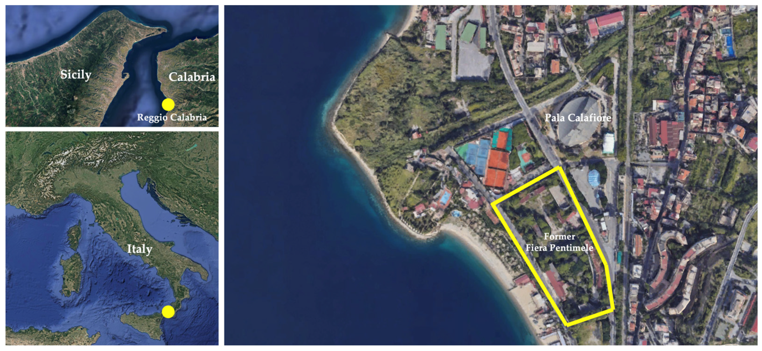
Pentimele is located in the northwestern sector of Reggio Calabria, a city situated at the southern tip of Calabria, overlooking the Strait of Messina (
Figure 1). The name derives from the homonymous hill, and the area combines residential, commercial, and industrial zones, positioned a short distance from the historic center. Its strategic location ensures good connectivity to the seafront and the region’s main roadways.
The former Fiera Pentimele, the subject of this study, is a large disused area of about 30,000 m2 that once hosted trade fairs and commercial activities. Situated at the boundary between Pentimele and the urban periphery, the area has undergone progressive abandonment, leading to a loss of functionality and increasing isolation due to the lack of adequate services and infrastructure. This context offers potential for regeneration projects aimed at transforming the area into a revitalized, multifunctional urban space.
From an urban planning perspective, the low building density and the presence of abandoned buildings give the area a degraded appearance but also offer an opportunity to rethink the urban landscape by integrating new functions and improving infrastructure. The area is currently fragmented, lacking clear integration between its different land uses, but it could benefit from recovery interventions that promote a better balance between residential, commercial, and social needs.
In terms of accessibility, Pentimele is well connected to the main road network and the city’s transport hubs, but it suffers from significant shortcomings in terms of safe pedestrian and cycling pathways. This limitation represents a crucial challenge for the development of projects such as the “sports city”, aimed at promoting healthy and sustainable lifestyles.
From a socio-economic perspective, Pentimele is in a transitional area, alternating between developed zones and more problematic contexts. Youth unemployment and the limited presence of economic activities hinder the area’s development, reducing its attractiveness. However, the interest of local institutions and civic organizations in the regeneration of Pentimele indicates growing potential. Projects such as the sports hub could serve as a catalyst for job creation and the initiation of cultural and tourism activities, contributing to the city’s image enhancement.
The urban regeneration plan, aligned with the objectives outlined in the ‘Piano Urbano della Mobilità Sostenibile (PUMS)’ of the Metropolitan City of Reggio Calabria [
31], also aims to improve sustainable mobility by integrating the area with the rest of Reggio Calabria through new public transport networks and pedestrian and cycling paths.
This approach aims to overcome the sense of marginalization that has characterized Pentimele in recent years, fostering greater cohesion with the urban fabric.
Given its location along the Strait of Messina, the Pentimele area is particularly vulnerable to environmental risks, including coastal erosion and rising sea levels. These challenges necessitate innovative planning approaches, incorporating floodable buildings, portable structures, and other adaptive design elements to enhance resilience.
Finally, the environmental aspect plays a central role. Pentimele’s privileged position, with its seafront and surrounding green areas, requires a regeneration project that respects sustainability principles, enhancing natural resources and integrating solutions for energy efficiency and environmental impact reduction.
4. Materials and Methods
The economic-financial evaluation of the “Parco dello Sport” in Pentimele, Reggio Calabria, followed a well-structured methodological process. This approach is divided into several key phases, designed to offer a comprehensive analysis to support decision-making for the design and realization of a multifunctional sports hub. Each phase is aligned with the project’s overarching goals of assessing economic, social, and territorial impacts and contributing to sustainable urban regeneration.
The main phases of the methodological process include the following:
Preliminary analysis of the territorial and urban context.
Identification of local demand and community needs.
Strategy and project scenarios.
Discounted Cash Flow Analysis (DCFA).
Cost-benefit analysis (CBA) and impact assessment.
Sensitivity analysis and stakeholder engagement.
This structured approach enabled a rigorous evaluation of both the direct and indirect economic benefits of the project, as well as its social and territorial impacts, which are critical for future design and policy decisions [
32,
33]. As part of the analysis, practical guidelines for urban planners and policymakers were derived from similar cases, focusing on the integration of environmental, social, and technological aspects in urban regeneration projects [
26]. In addition, parking provision was analyzed as a key element to address the needs of a facility with a capacity of 400–500 users, alongside considerations for promoting public transport connectivity to enhance accessibility and sustainability.
The following subsection details the methodology adopted and its application, with particular focus on the use of the DCFA and the CBA to assess the economic feasibility and social sustainability of the proposed project.
4.1. Preliminary Analysis of the Territorial and Urban Context
The first phase of the methodological process involved an in-depth analysis of the territorial and urban context surrounding the former Fiera Pentimele site in Reggio Calabria, which is currently in a degraded state. The purpose of this phase is to gather data on the area’s physical, social, and economic characteristics, and to identify key opportunities for transformation and urban revitalization.
Geospatial data were collected through the use of Geographic Information Systems (GIS) tools, which provided detailed mapping of the area, and a SWOT analysis was conducted to identify the main opportunities and challenges [
34,
35].
Demographic data from the Municipality of Reggio Calabria were analyzed, which includes population distribution, socio-economic profiles, and historical trends in the area [
36].
Previous studies on urban regeneration specific to Pentimele and similar areas were reviewed. This phase included the availability of nearby transportation infrastructure and parking, in addition to the project’s parking facilities, identifying gaps that could impact accessibility. To address these gaps, the potential integration of public transport solutions, such as shuttle services or enhanced bus routes, was explored.
Furthermore, the study gave higher attention to the environmental dimension of the project, ensuring that considerations related to sea-level rise, movable structures, and floodable buildings were embedded in the design. These guidelines underscore the importance of integrating environmental risks into urban planning processes [
27].
The selection of Reggio Calabria as a case study was driven by its current socio-economic challenges and its strategic location in the Metropolitan Area of the Strait. This area has significant potential for urban revitalization, especially considering the site’s proximity to the waterfront and the ongoing urban renewal efforts by the local administration. The choice of this site aligns with global trends in urban regeneration, making it a suitable case for analyzing the role of multifunctional sports infrastructure in promoting sustainable development.
In addition to these data sources, a SWOT analysis was employed to assess the strengths, weaknesses, opportunities, and threats associated with the project area. This approach was crucial for identifying strategic opportunities for development [
34,
35]. The analysis focused on key factors such as accessibility, connectivity with the broader city, and the potential for sustainable development through regeneration initiatives.
The analysis also took into account the Floor Area Ratio (FAR) of the proposed project, which is 0.6, to assess its feasibility in light of potential licensing challenges and climate-related risks, including sea-level rise.
4.2. Identification of Community Demand
Understanding the needs of the community is central to the project, especially for assessing the demand for sports, cultural, and social spaces. A mixed-methods approach was adopted for this phase, combining quantitative and qualitative data collection techniques to capture a broad range of community needs.
Data sources for this phase include the following:
Surveys administered through structured questionnaires to a representative sample of the local population.
Focus groups with local stakeholders, including community leaders, residents, and potential users of the sports facilities.
The survey design included both closed and open-ended questions, allowing for statistical analysis as well as deeper qualitative insights. The statistical data from the surveys were analyzed to identify key preferences, while qualitative data from the focus groups were coded to detect common themes related to the need for specific facilities and services.
In addition to these methods, the study included interviews with 70 local stakeholders, including citizens, community leaders, public administrators, and potential users of the facility. The interviews focused on transportation preferences, desired functions of the facility, and accessibility. The responses were recorded, transcribed, and analyzed qualitatively to identify recurring themes.
A structured questionnaire was distributed to a sample of 300 residents, with a response rate of 65%. The data were processed using IBM SPSS Statistics version 30 for statistical analysis, focusing on preferences regarding transportation and the functions of the facility.
By employing this approach, the study ensured a comprehensive understanding of the local community’s needs, allowing for the identification of priorities and preferences that would guide the project design [
35,
36,
37,
38,
39].
4.3. Strategy and Project Scenarios
The Municipality of Reggio Calabria, together with the current manager of the city’s sports district, has initiated a strategic urban design process aimed at revitalizing the area adjacent to the existing sports hub. The objective is to create a new multifunctional sports infrastructure aligned with the technological and functional standards of next-generation urban design models.
The strategic location of the proposed infrastructure is a key factor in the success of the project, which aims to enhance the territory by creating an infrastructure capable of offering benefits to the community and acting as a catalyst for urban regeneration. The site is intended to serve not only the immediate urban area but also the broader Metropolitan Area of the City of Reggio Calabria, as well as the forthcoming Metropolitan Area of the Strait, which will be formed by the merger with the Metropolitan Area of Messina, with a total population of approximately 730,000 inhabitants.
However, the high construction cost necessitates the adoption of a Public–Private Partnership (PPP) model, in which the private sector would manage the economic activities to recover investment, while the infrastructure ownership would remain public.
Data from the territorial analysis phase provided key insights for developing different project scenarios, each featuring varying levels of multifunctionality. These scenarios were designed to maximize the economic, social, and environmental outcomes of the project [
33,
40,
41], using an iterative process that involved urban planning experts, local stakeholders, and community representatives [
39].
4.4. Discounted Cash Flow Analysis (DCFA)
The Discounted Cash Flow Analysis (DCFA) [
42,
43,
44] was applied to evaluate the economic feasibility of the project, considering both costs and revenues. The analysis incorporated estimates for construction and operational costs, along with expected revenues from the activities and services offered (such as facility space rentals, event organization, and commercial activities), based on benchmarks from similar projects [
42,
43].
In the Discounted Cash Flow Analysis (DCFA), the main evaluation criteria employed are the Net Present Value (NPV) and the Internal Rate of Return (IRR).
The NPV represents the present value of future cash flows associated with the project, discounted at a specific rate. It is calculated using the following formula:
where:
Ft = Rt − Ct: the net cash flows at time t, defined as the difference between revenues (Rt) and costs (Ct)
C = investment and management costs
r = discount rate, equivalent to the opportunity cost of capital
t = duration of the investment (ranging from 0 to T)
This equation ensures that future cash flows are appropriately discounted to reflect their present value, enabling a robust assessment of the project’s economic viability. The selection of the discount rate was based on market conditions and risk factors associated with the project. An NPV > 0 indicates that the project generates positive economic value, while an NPV < 0 implies a loss.
The Internal Rate of Return (IRR) is the discount rate at which the NPV equals zero. It is determined by solving the following equation:
The primary aim was to assess the financial feasibility of the project within the framework of the Public–Private Partnership (PPP) model [
44,
45,
46].
The financial projections were based on data from comparable projects, adjusted for local economic conditions. The analysis also examined funding sources, including potential public contributions and private sector investment, ensuring that the project could sustain itself economically over the long term [
44,
45,
46,
47].
4.5. Cost-Benefit Analysis (CBA) and Impact Evaluation
A Cost-Benefit Analysis (CBA) was conducted to evaluate the overall effectiveness of the investment. The construction and management costs were weighed against the social, economic, and environmental benefits of the project [
48]. These benefits include improvements in local employment, tourism, social cohesion, and quality of life, compared against construction and management costs.
The analysis also incorporated ecological impacts and transportation issues, providing strategies to minimize negative effects and optimize resource use [
44,
45,
49,
50,
51].
Additionally, the project’s potential to generate non-monetary benefits, such as community well-being and environmental enhancements, was factored into the analysis using qualitative assessments. These considerations provided a holistic understanding of the investment’s societal value.
The CBA utilized the following equation:
where:
Bt represents the total benefits at time t;
Ct indicates the total costs at time t;
r is the annual discount rate;
T is the evaluation period.
4.6. Sensitivity Analysis and Stakeholder Engagement
A sensitivity analysis was carried out to assess the robustness of the economic-financial model and the results of the Cost-Benefit Analysis under different scenarios. This analysis considered variations in key variables, such as construction costs, revenue projections, and market conditions, to test the project’s resilience to potential fluctuations [
44,
46,
47,
48,
49,
50,
51].
The sensitivity analysis allowed for the identification of critical factors that could impact the project’s sustainability. Furthermore, an engagement process with key stakeholders was undertaken, including local citizens, public administrators, potential investors, and other relevant actors. This involved consultation meetings, 70 semi-structured interviews, and distribution of a questionnaire to 300 residents. These consultations, focus groups (at the initial stage of the pre-feasibility study and at a later stage during the presentation of the proposed project), and feedback sessions were conducted to gather opinions, ensuring that the project would meet the community’s needs and secure broad support local for its implementation.
5. Results
5.1. Preliminary Analysis of the Territorial and Urban Context
The analysis phase of the territorial context played a crucial role in defining the physical, socio-economic, and infrastructural characteristics of the Pentimele area. GIS tools were used to create detailed maps identifying resources and territorial challenges. Additionally, economic and social context data were collected and processed for the study area [
52].
Overall, the data highlighted a socio-economic reality characterized by a high percentage of elderly people, employment challenges for young people, and economic vulnerability for part of the population. Specifically, the total population is 10,000, with 25% aged 15–29 and 35% over 65. Youth unemployment stands at 40%, while 30% of households live on low incomes. This requires careful consideration of policies and strategies to stimulate youth employment, support low-income families, and improve living conditions for the elderly.
The analysis also highlighted the main infrastructure present in the area, the distribution of public services, and degraded zones. It shows significant potential for redeveloping the area, characterized by large unused spaces and good accessibility from central areas. However, the lack of modern infrastructure and public services represents a significant barrier to development. Designing a multifunctional sports complex could contribute to improving local quality of life and stimulate economic growth.
The Pentimele area is strategically located, well-connected to major roadways, and close to the city center. The GIS analysis revealed a lack of structured sports spaces but also great potential for integration with the existing urban fabric. Additionally, the proximity to established infrastructure such as the seafront and ‘Pala Calafiore’ provides an important advantage for the project.
5.2. Identification of Local Demand and Community Needs
The demand analysis was based on a mixed-methods approach [
5,
8,
39,
40,
41], which included the following:
Questionnaires distributed to a sample of 300 residents in the area.
Semi-structured interviews conducted with representatives of local sports associations, community leaders, entrepreneurs, and public administrators.
A comparative analysis with similar projects implemented in other Italian cities.
Several alternative scenarios were explored, considering the evolution of sports infrastructure in the city, the impact on the community, and the potential for daily use of the area. The scenarios evaluated different functional configurations, including multifunctional spaces, supporting services, and the creation of a sports hub that could attract and serve neighboring cities.
In total, two meetings were held with the local community at different stages of the project, in the initial pre-feasibility study phase to identify the needs for the development of the sports facility and in a later phase when the proposed solution was presented. These meetings focused on gathering feedback and addressing concerns regarding accessibility, transportation, and the facility’s functions.
The data collected were processed using statistical software such as SPSS to identify trends and specific preferences of potential users [
5,
8,
39,
40,
41].
The demand analysis revealed that the local population expresses a strong demand for infrastructure that combine sports, culture, and entertainment. The majority of residents consider the creation of a multifunctional hub necessary. The main requests include the following:
Spaces for indoor and outdoor sports (52%)
Green areas for recreational activities (45%)
Commercial and dining facilities (36%)
Additionally, semi-structured interviews with key stakeholders, including local residents and community leaders, provided qualitative insights into the community’s preferences. The interview questions focused on issues such as transportation preferences, desired functions of the project, and the impact on local traffic and accessibility.
The interviews were transcribed, and the responses were analyzed for common themes and key issues, which were integrated into the design process to ensure that the facility would meet the community’s needs.
5.3. Project Strategy and Scenario
The strategy and project scenarios outlined are the result of a thorough process of preliminary analysis and the development of the socio-economic context of the study area. Specifically, the analysis of the territorial and urban context provided a detailed understanding of the physical, socio-economic, and infrastructural characteristics of the Pentimele area, while identifying local demand and community needs, which gathered crucial information on the population’s expectations and requirements. This process led to the definition of a project scenario that addresses the emerging needs, aiming to transform the former Fiera Pentimele into a strategic multifunctional hub for the city.
The former Fiera Pentimele area is positioned as a key node for urban regeneration and the creation of a multifunctional infrastructure that combines sports, recreational, and cultural activities. The design vision aims to enhance the area by integrating multipurpose spaces for sports, leisure, and socialization, with the ambition of transforming the district into a reference point for the entire metropolitan area.
Professional and amateur sports clubs will find an ideal environment for training and competitions within the area. The project includes the integration of various sports, ranging from football and tennis to swimming and fencing, with modern facilities that will not only benefit the local community but also attract national and international events.
The city’s demographic analysis highlights the progressive aging of the population, with a significant increase in the over-65 age group. These data call for the inclusion of socio-health services and accessible spaces within the project, which are capable of addressing the needs of an increasingly diverse population. The multifunctional infrastructure will not only meet entertainment and sports needs but will also include specific amenities and services designed to enhance well-being, such as wellness centers, green spaces, and community-oriented facilities. These additions aim to foster an inclusive environment that prioritizes physical and mental health, social interaction, and overall community vitality, adopting an inclusive and sustainable approach for the local community.
Spanning approximately 37,000 square meters, the former Fiera Pentimele area holds great potential to host a wide range of infrastructure. These facilities will offer ample opportunities for sporting events, concerts, and cultural activities, reinforcing the multifunctional vocation of the area.
The proposed project includes a multifunctional arena with a capacity of 400–500 seats, providing spaces for sports, cultural, and congress events, in addition to commercial, hospitality, and socio-health services. This new infrastructure aims to create a new center for urban and economic development, used daily by the citizens, and serve as a catalyst for territorial and urban regeneration.
The economic sustainability of the project is ensured through a public–private partnership, where the private sector will finance the construction of the infrastructure and temporarily manage economic activities, such as commercial, hospitality, and socio-health services. This model will allow for efficient resource management and promote continuous use of the multifunctional infrastructure, solidifying its role as a new urban agora.
The design strategy aims to transform the former Fiera Pentimele into an urban landmark that stimulates the regeneration of the surrounding area and strengthens the sense of community. The multifunctional infrastructure will host sports, cultural, and conference events with a capacity of approximately 400–500 seats. Sports facilities, along with dining and commercial services, will create a lively environment capable of attracting users throughout the day.
5.4. Discounted Cash Flow Analysis (DCFA)
The Discounted Cash Flow Analysis (DCFA) of the Sports Park project has provided a detailed view of its economic feasibility, taking into account the costs and revenues derived from the planned intervention. The parametric costs, as mentioned, were obtained through the DEI price list [
53] and other reliable direct sources, enabling a precise estimate of the costs for each functional block of the project [
49,
54,
55]. The intervention was divided into macro-lots, allowing for a gradual implementation according to a timeline, with homogeneous cash flows that spread the investments over time.
From a cost perspective, the intervention includes various infrastructural aspects, such as the creation of public green spaces, parking areas, roads, utility services, and key structures like the sports area, commercial area, and the socio-healthcare residence for the elderly. The costs were estimated using official price lists [
46] and, where not available, were based on recent constructions in similar or neighboring contexts to the study area [
49,
54,
55].
As shown in
Table 1, the largest expenditure is allocated to the construction of sports infrastructure, which has a higher cost per square meter compared to all other structures in the project. The construction of the RSA (residenza socio-sanitaria for the elderly) and the commercial area, though similar in terms of quantity and square footage, have lower unit costs, almost half the cost of the sports area. The total cost of the intervention, including urbanization costs and technical expenses, amounts to EUR 62,545,684.
Regarding revenues, as shown in
Table 2, the sports area is excluded from generating revenue, as it is intended for exclusive use by the public and the sports clubs within the adjacent sports complex. The commercial area constitutes one of the two main sources of income for the investment. Revenues in this case were calculated based on a monthly average of the rental cost per square meter for a commercial space in the city of Reggio Calabria at the time of the estimate, approximately EUR 10 per square meter. Moreover, the project includes the construction of a socio-healthcare residence for the elderly. As mentioned earlier, Reggio Calabria will inevitably need this service in the coming years, given demographic aging and the shortage of beds in such services. Revenue from this service, based on 200 beds proposed in the project, was calculated based on regulated prices in municipalities within the metropolitan city of Reggio Calabria, the Calabria region, and some companies operating in the capital of Calabria. The projected fee for each bed is approximately EUR 90 per day, or EUR 2700 per month per bed. This estimate was derived from market research and comparisons with similar services in the region.
In terms of total revenues, the annual total generated by the investment, excluding the sports infrastructure (as it is managed by the public administration), amounts to EUR 6,084,000.
The cost–revenue analysis, calculated over an economic flow of 25 years (the estimated duration of the public–private partnership management), generates a total revenue of EUR 152,100,000. The five years of construction work are excluded from this calculation.
The total revenue over 25 years comfortably covers the costs incurred for the construction of the entire urban block. However, considering the economic flow and financial exposure, from a private investment perspective, these revenues are unsustainable in the short term, as there are no immediate revenues. Indeed, assuming the proposed timeline for the interventions, all services, including the sports area and commercial area, should be built simultaneously to set up the multifunctional infrastructures, followed by the completion of the RSA. The estimated timeline is about 15 quadrimesters, or 5 years; from that point onward, revenues will begin to cover expenses and increase the profits generated.
5.5. Cost-Benefit Analysis (CBA) and Impact Evaluation
The Cost-Benefit Analysis (CBA), unlike the DCFA, also estimates the benefits produced by the intervention at a monetary level, integrating and monetizing them over the duration of the effect within the analysis [
48]. Regarding this intervention, the benefits produced were calculated using the “Benefit Transfer” methodology [
56], considering aspects such as new jobs created by the three main functions, the willingness to pay for sports activities, and how such an infrastructure could increase the percentage of people able to engage in sports within the city, given its proximity to the city’s sports park. Finally, the increase in property values within the City of Reggio Calabria due to the introduction of these new infrastructures was calculated.
The first factor calculated was the creation of new jobs. The benefit generated by the new sports infrastructure is one job for every 200 seats [
42], considering the sports area’s capacity to host approximately 500 seats. Regarding the RSA (social-healthcare residence), the calculation was based on the average number of jobs generated by similar healthcare infrastructures in the metropolitan city of Reggio Calabria, with one job for every two available beds, using the RSA as the primary reference due to its similar size. For the new commercial area, the calculation was based on the average number of jobs generated by similar infrastructures in the nearby areas, estimating one job for every 75 square meters of gross floor area dedicated to this service. The benefit calculated is based on the sum of the average net annual salaries.
The total monetized benefit generated annually is approximately EUR 6,529,944.
Secondly, the willingness to pay (WTP) for sports services was calculated (
Table 3). This was calculated by considering, according to ISTAT data, the adult working-age and income-generating population [
57]. The final value was calculated by applying the percentage of people in the city who could engage in sports, based on the national percentage retrieved from ISTAT. The WTP value was taken from the publication by Fujiwara et al., 2014 [
43], extracting the coefficient used for “All Sports” and multiplying it by the average annual net salary of a dependent citizen residing in the metropolitan city of Reggio Calabria, using data from the Unione Industriale of Reggio Calabria, and adjusting this data to 2021 based on inflation [
58,
59]. The final total, monetized, is approximately EUR 12,171,936 annually.
The third and final benefit calculated was the increase in property values (
Table 4). Within a 1.6 km
2 radius, a conventional value was used as it represents the distance that can be walked in 15–20 min from the site undergoing urban transformation. The value used was provided by the publication of F. Xia and R. Humphreys, 2012 [
60], which calculated the average increase in property value generated by the introduction of sports infrastructure within a city after its completion. This value, calculated in 2012, was estimated at approximately USD 793 per property unit. Using the geoportal of the metropolitan city of Reggio Calabria, the number of properties within the influence area was calculated, and unused properties were subtracted using ISTAT data [
57]. The dollar value was updated and converted to euros, adjusting it to current values based on inflation.
The generated value was then multiplied by the number of occupied properties within the influence area, monetizing the benefit. In this case, the value generated from monetizing the benefit is approximately EUR 8,511,586.
The values generated through the Benefit Transfer methodology were monetized and included in the economic-financial analysis. With the aim of setting up the economic analysis over a 30-year period, these values are applied following the completion date of the entire urban transformation, effectively covering a total of 25 years based on the hypothesized timeline. The benefits generated from the creation of new jobs and those related to the citizens’ willingness to pay were calculated and included in the analysis from the fifth year until the thirtieth year, with these benefits being calculated annually over the entire duration of the schedule. As for the benefit generated by the increase in property values, this is considered only once the construction of the entire urban block is completed.
This cost-benefit analysis is conducted because the urban transformation project of the area under study is developed based on input from a public entity, such as the city of Reggio Calabria. From the financial perspective of the private investor, this investment is not immediately remunerative but only over a long-term horizon. However, the benefits produced, and monetized within the economic-financial analysis, concerning the public sector, are sufficient and numerous to justify the investment and the realization of these new urban infrastructures.
5.6. Sensitivity Analysis and Stakeholder Involvement
5.6.1. Sensitivity Analysis DCFA
Once the overall values of the financial and economic analysis are calculated, it is possible, starting from profitability values [
44,
45,
46,
47,
54] such as the Net Present Value (NPV), which indicates the difference between the present value of the incoming cash flow (expected revenues) and the present value of the outgoing cash flow (costs and expenses to be incurred) over a specified time period, and the Internal Rate of Return (IRR), used as an indicator to determine the profitability of a potential investment or project, to develop a sensitivity analysis (
Table 5). The IRR provides information about the project, indicating that a positive IRR suggests potential profitability, while a negative IRR could represent slow or minimal growth.
The previously developed analysis, both related to cost–revenues and cost–benefits, has allowed for the development of this data, which can now be used in this phase to define an additional analysis—sensitivity analysis. This analysis helps understand which variables most impact the project performance and the overall analysis. The sensitivity analysis is carried out by varying the profitability index values, which change depending on input data. This is done by adjusting individual cost and revenue values by +/−15%. Once these data adjustments are made, the IRR is recalculated for each data point within the calculation tables, generating a new value. This variation is identified through a percentage value relative to the initial reference value, considering the initial value as a constant within the replaced variables.
The collection of all these data, along with the modified IRR value for each variable, allows for the creation of a graph that illustrates the impact of input variable changes on the resulting outcomes. The graph, generated through straight lines, shows the percentage change in IRR for each of the considered variables relative to the percentage change in unit values.
The impact is determined by the cost or revenue variation that generates a change in the IRR. The collection of lines, representing all possible variables in the analysis, indicates the sensitivity of each cost item within the investment. Through the slope of the lines developed using the variable values relative to the zero axis, it is determined which item has the greatest impact on the feasibility of the investment.
The larger the angle between the zero axis and the slope of the line, the greater the possibility that the variable may influence the final result of the project.
Regarding the sensitivity analysis of the investment with respect to the cost–revenue analysis, it was calculated starting from the reference IRR of 3.82%, a relatively low but positive value. To calculate the slope values and define the sensitivity of each variable relative to the investment, the unit construction costs for the sports area, the socio-health residence (RSA), and the commercial area were used as reference. Individual costs in the table were modified by +/−15%. Adjusting each data point in the input table resulted in changes in the IRR, which were then inserted into the appropriate cell, generating a positive or negative percentage value. This procedure was repeated for all values in the input table, related to the hypothesized revenues from the RSA and the commercial area. Finally, the values were gathered and used to generate the reference graph, with straight lines representing the percentage variables of costs and revenues in the calculation tables. The generated graph shows that the primary variable that could influence the investment is the RSA revenue, as visible, the angle between the line and the zero axis is greater compared to the other variables (
Figure 2).
5.6.2. Sensitivity Analysis CBA
Regarding the sensitivity analysis of the investment in relation to the cost-benefit analysis [
48], it was calculated starting from a reference value of the Internal Rate of Return (IRR) of 27.31%, a very high value that includes, compared to the cost–revenue analysis, the monetization of the potential benefits that the investment could generate in the territory (
Table 6).
The monetized benefits calculated, as previously mentioned, include the potential jobs generated in the area, related to the sports, commercial, and socio-health functions. The data included in the analysis reflects the possible net monthly salary for each worker. The subsequent benefit calculated and included in the sensitivity analysis refers to the Willingness To Pay (WTP), the annual Willingness To Pay (WTP) for engaging in sports activities, attributed to each adult citizen generating income within the city, but calculated based on the national percentage of people who could engage in sports. The last monetized benefit is the potential increase in the value of the properties located within the influence radius of the urban transformation.
These, together with the key cost and revenue values calculated in the cost–revenue analysis, were used for the sensitivity analysis. The individual unit costs, entered into the input data table, as previously done, are modified by a value of +/−15%, allowing the recalculation of the IRR, which is then inserted into the calculation tables. This process is repeated for each individual item to calculate all the variables needed for the analysis.
The generated values were then used to develop the reference graph, using straight lines that represent the percentage variables of costs, revenues, and monetized benefits within the calculation tables. From the generated graph, it can be seen that all variables have a homogeneous angle relative to the zero axis, but it is evident that the items related to the construction of the sports area and the monetized benefits of the willingness to pay are the main factors that could influence the success of the project (
Figure 3).
6. Discussion
The results of this study confirm the potential of multifunctional sports infrastructures as catalysts for urban regeneration, economic development, and social inclusion. These findings are consistent with previous research using Structural Equation Model (SEM) methods [
61,
62], which underscore the importance of multifunctional infrastructures in enhancing urban vitality. However, our study distinguishes itself by integrating social and healthcare services for the elderly, an innovative component that expands the analytical framework of the 5D theory applied to urban vitality measurement. The case study of the former Fiera Pentimele highlights that the integrated design approach, based on multifunctionality, is particularly effective in marginalized urban contexts. The economic-financial and cost-benefit analysis demonstrated that the integration of sports, cultural, and commercial spaces generates a significantly higher return on investment compared to traditional configurations, producing direct benefits (jobs and increased revenues) and indirect benefits (property value enhancement and social cohesion). These findings not only validate the model’s applicability to other contexts but also provide a robust framework for policymakers seeking to optimize resource allocation in urban regeneration projects.
The research questions raised in the introduction are addressed through our study’s findings. The first question, concerning the relationship between multifunctional infrastructures and urban vitality, has been answered by demonstrating how these structures significantly contribute to social cohesion and economic growth. The second question explored regional differences, and our data confirm that multifunctional infrastructures can be adapted to diverse local needs, supporting the 5D theory [
63,
64]. Lastly, the third question, focused on policy implications, suggests that urban policies should prioritize the implementation of multifunctional infrastructures to maximize positive community impacts [
65]. This emphasizes the necessity for urban planning strategies to adopt a bottom-up approach, incorporating localized needs and stakeholder engagement to ensure successful implementation.
When comparing these data with previous studies, a convergence emerges that multifunctional infrastructures not only optimize the use of urban spaces but also create a sustainable balance between economic, social, and environmental needs. Compared to similar experiences in European contexts [
42,
43], the Pentimele project stands out for its inclusion of social and healthcare services dedicated to the elderly, an innovative design choice that addresses the progressive demographic aging of the local population. This element, while less common in urban regeneration projects, underscores the importance of adapting infrastructures to the specificities of the territory and its socio-economic dynamics. The ability to tailor these models to address local demographic and economic realities reinforces their replicability in cities facing comparable challenges, offering transferable solutions for urban resilience.
The sensitivity analysis also highlighted the robustness of the proposed model, even in scenarios with significant variations in economic and social parameters. However, some challenges remain, including the need to mitigate the environmental impact of the project through advanced technological solutions and the construction of low-energy impact infrastructures. Innovations such as renewable energy integration, smart building technologies, and material recycling systems could enhance the project’s environmental sustainability. Additionally, an effective governance strategy and collaboration between the public and private sectors will be crucial to ensuring the long-term sustainability of the project.
In the broader context of urban planning, the results suggest that similar approaches could be replicated in other cities with similar socio-economic and territorial characteristics. This study highlights the importance of creating transferable models for multifunctional infrastructures that can be adapted to the unique contexts of different urban areas. Clear guidelines for public–private partnership frameworks and monitoring mechanisms should be developed to ensure the replicability of these strategies. However, future studies should further investigate the evaluation of environmental impacts, considering the adoption of circular economy models and digital technologies for the management and maintenance of infrastructures. Moreover, a post-implementation longitudinal analysis will be essential to monitor the actual effectiveness of the project in terms of social inclusion and economic sustainability.
In conclusion, the policy implications of this study highlight the importance of an integrated approach to urban infrastructure planning. Practical recommendations suggest that other cities should adopt planning strategies that promote the integration of multifunctional services to improve urban quality of life and sustainability. By fostering knowledge transfer among cities and regions, these models could serve as blueprints for achieving urban regeneration goals in diverse socio-economic contexts. This approach not only stimulates the local economy but also fosters social cohesion, making cities more resilient and inclusive [
64,
65].
7. Conclusions
In conclusion, the study of the former Fiera Pentimele demonstrates how a multifunctional infrastructure, designed with an integrated approach, can serve as a strategic lever for urban regeneration and the economic revitalization of an area [
66]. The project, with its combination of sports, cultural, commercial, and socio-health spaces, not only addresses the immediate needs of the local community but also lays the foundation for long-term sustainable development [
67].
The adoption of a Public–Private Partnership (PPP) model [
68] proved to be a winning choice, enabling a balanced economic burden between the parties involved and ensuring efficient resource management. Furthermore, the integration of advanced analytical tools, such as economic-financial and cost-benefit analysis, provided a solid decision-making framework that is replicable in other urban contexts. This replicability reinforces the model’s potential as a practical tool for urban planners and decision-makers worldwide, particularly in regions with similar socio-economic conditions.
The success of the project will depend on overcoming certain operational challenges, such as the active involvement of the community throughout all stages of development and the management of environmental and logistical aspects. Given its proximity to the Strait of Messina and its vulnerability to coastal erosion [
27], the environmental aspects of the project received particular attention. This included design compliance and approaches to innovative architectural guidelines such as floodable buildings, lightweight and mobile/portable structures, and building setbacks to mitigate risks associated with sea-level rise. These adjustments reflect a stronger commitment to the environmental dimension, ensuring the project’s resilience to the impacts of climate change. In this sense, the project represents not only an innovative model for Reggio Calabria but also a laboratory for experimenting with new forms of integrated and participatory planning [
69,
70]. This underscores the importance of continuous monitoring and the iterative adaptation of the model to respond dynamically to emerging challenges during implementation.
Since the analysis primarily focused on the scope of a single case study, the dataset used is limited in terms of both size and geographical representativeness, and the adopted methodology may not capture all relevant variables. These factors restrict the generalizability of the results to broader contexts [
71,
72]. The inclusion of additional case studies from diverse geographical and cultural settings would help refine and validate the findings, improving their applicability across different urban environments. Future studies could expand this analysis by exploring diverse geographical contexts, allowing for a deeper understanding of the variability of the analyzed phenomena [
73]. In particular, applying the model in regions with distinct socio-economic and environmental challenges—such as rapidly growing urban areas or regions with significant economic disparities—could provide valuable insights into its flexibility and adaptability. Furthermore, future analyses should explicitly examine the environmental performance of such models in coastal areas, focusing on their capacity to mitigate environmental risks while maximizing social and economic benefits. Another promising direction could involve the use of larger and more diverse datasets, combined with alternative methodological approaches such as machine learning or interdisciplinary models [
74]. Such developments would provide a more comprehensive and comparative framework for assessing the analyzed impacts, offering valuable insights for applications in different contexts.
This study makes a significant contribution to the urban regeneration debate, highlighting the crucial role of multifunctional infrastructures as an enabling factor for social cohesion and economic development. The proposed model can serve as a reference for policymakers, urban planners, and investors interested in transforming degraded urban areas into engines of innovation and inclusion. To enhance its relevance, the model should also consider regional policy frameworks and regulatory environments, tailoring implementation strategies to align with local governance systems.
Finally, future studies should focus not only on the implementation of strategies for maximum integration of environmental and technological components, but also on the exploration of how these strategies might perform in diverse settings and under alternative planning approaches. Testing the model’s effectiveness in different urban systems, including mid-sized cities and rural-urban transition areas, would further consolidate its robustness and replicability. Such efforts would strengthen its role as a transferable solution for urban challenges on a global scale.


