Article

Evolutionary Characteristics, Improvement Strategies and Driving Mechanisms of the Human Settlement Environment in Chinese Traditional Villages Based on Historical Hydrological Resilience Assessment

1
School of Civil Engineering and Architecture, Jiangsu University of Science and Technology, Zhenjiang 212100, China
2
School of Architecture and Urban Planning, Nanjing University, Nanjing 210093, China
3
Zhenjiang Planning Survey and Design Group Co., Ltd., Zhenjiang 212002, China
4
School of Architecture, Southeast University, Nanjing 210096, China
*
Authors to whom correspondence should be addressed.
Buildings 2025, 15(23), 4264; https://doi.org/10.3390/buildings15234264
Submission received: 30 September 2025 / Revised: 12 November 2025 / Accepted: 21 November 2025 / Published: 25 November 2025
(This article belongs to the Section Architectural Design, Urban Science, and Real Estate)

Abstract

(1) Background: In the context of rapid urbanization and climate change, Chinese traditional villages are facing severe challenges such as deterioration of hydrological environment, weakened social resilience, and degradation of cultural heritage. (2) Methods: This paper took Baoyan Village in Zhenjiang City, Jiangsu Province as the research object and constructs a research framework of “assessment of historical hydrological resilience–diagnosis of current problems–construction of enhancement strategies”, aiming to explore the paths and driving mechanisms for enhancing the resilience of traditional villages. The spatio-temporal evolution of historical hydrological resilience in Baoyan Village was quantitatively evaluated by establishing a three-dimensional resilience index system of “ecological governance–social adaptation–cultural continuity”, combined with the Analytic Hierarchy Process (AHP) and GIS spatial overlay technology. (3) Results: The study found that ① The hydrological resilience zoning of Baoyan Village presented spatial differentiation characteristics of “core vulnerability-marginal resilience”, and the high-risk area was concentrated in the cultural building density area along the old Tongji River in the historical town area, indicating that this area requires key flood protection and resilience construction; ② this paper constructed a composite evaluation system of “Ecological Governance–cultural inheritance–social adaptation”, and the total score after evaluation was 0.67, indicating that the overall HHRI of Baoyan Village has declined. Specifically, the scores for Ecological Governance Resilience and Cultural Heritage Resilience were 0.48 and 0.46, respectively, reflecting a significant decrease compared to historical scenarios. Conversely, the score for Social Adaptation Resilience was recorded at 1.05, suggesting an improvement in this dimension. This enhancement can be attributed to advancements in water infrastructure and increased levels of community organizational support, which have bolstered the village’s capacity to withstand flooding events. ③ The integrity of weir fields, the transmission of traditional disaster prevention knowledge, and the stability of natural river channels are the main factors hindering the improvement of resilience systems. (4) Conclusions: Based on the assessment results, this study proposed the resilience enhancement path of “ecological space reconstruction-traditional water management wisdom activation–cultural resilience empowerment” for this case, and constructed a four-pronged driving mechanism consisting of government guidance, community participation, technology empowerment, and industrial synergy for implementation. Practice has shown that through specific strategies such as restoring the weir and field system, constructing sponge village units, and developing the rain and flood cultural experience industry, the key obstacle factors of the village can be effectively addressed, and the goals of flood safety and cultural inheritance can be achieved in a coordinated manner. This case provides an empirical reference that combines historical wisdom with modern technology for understanding the evolution of human–water relationships and the enhancement of resilience in traditional villages, and its research framework and methods are also of reference value for similar villages.

1. Introduction

1.1. Background

Chinese traditional villages are the crystallization of human wisdom in adapting to the natural environment, and their formation and development have always been closely related to the hydrological environment. However, in the process of rapid urbanization, traditional villages are facing problems such as water system destruction, aging flood control facilities, and degradation of ecological functions, especially in the hilly water towns of the Yangtze River Basin where the river network is dense and the terrain is complex, the decline in hydrological resilience is particularly significant.
The two main meanings of the Chinese character “yan” are closely related to water conservancy projects: one refers to a low dam, an artificial water-blocking structure used to intercept, store water or regulate water levels, which is usually smaller in scale than a “dam”, such as the famous Dujiang Yan in ancient China, or a barrier lake formed by natural landslides and mudslides blocking the river course; The second is a small water storage facility in farmland water conservancy, used for irrigation or aquaculture. As shown in Figure 1, traditional villages with the word “weir” in their names are clearly concentrated in the Yangtze River–Taihu Lake flood corridor, which is the core hub of the Yangtze River Delta flood control system, connecting the Yangtze River, Taihu Lake and the surrounding river network. The effectiveness of its governance is directly related to the flood control safety and ecological stability of the Yangtze River Delta Economic Belt.

1.2. Literature Review

This study provides a review at three levels: resilience of human settlements, historical hydrological dimensions, and driving mechanisms.

1.2.1. Theoretical and Practical Development of Human Settlements Resilience Assessment

The Resilience Theory originated from ecology and was proposed by Holling (1973) to describe the ability of a system to maintain its core structure and function after being disturbed, namely “ecological resilience” [1]. Since then, the theory has gone beyond the pursuit of “recovery to equilibrium” in engineering resilience and evolved into a social-ecosystem (SES) perspective, emphasizing the system’s adaptability, learning ability, and transformatory potential [2,3]. Under the guidance of this theory, the assessment of resilience in rural human settlements has become a frontier area in academia and policy practice.
Internationally, assessment methods are evolving from a single dimension to a multi-dimensional integration. For example, Harbiankova (2023) assesses resilience from five subsystems: social, economic, environmental, physical, and management, and emphasizes the pillar role of cultural heritage [4]. Cox (2015) developed community-actionable resilience assessment tools, focusing on the generation of localized data and long-term monitoring [5]. These studies provided methodological references for the construction of a multi-dimensional indicator system in this study.
Domestic research closely integrated with the rural revitalization strategy, forming multi-scale assessment practices. At the macro level, resilience evaluation index systems at the national or regional scale have been constructed to reveal spatial differentiation patterns [6,7]. At the micro village level, attention began to be paid to the impact of governance networks [8] and historical context [9] on resilience levels. These results provide important indicator references and comparison baselines for this study.
Three major trends are presented: firstly, the theoretical framework is constantly innovating, and the socio-ecosystem (SES) framework has become the mainstream analytical tool [10,11,12]; secondly, evaluation methods are becoming increasingly comprehensive, with multi-dimensional index comprehensive evaluation combined with spatial analysis emerging as a new paradigm [13,14]. Thirdly, research perspectives have become more diverse, focusing on the impact of governance models [15,16], digital technologies [17], and cultural capital [18] on resilience. It is notable that the spatiotemporal dynamics of resilience assessment have received particular attention.
In terms of technological evolution, the trend of quantification in the study of resilience assessment of rural human settlements has become increasingly prominent. For instance, the application of technical tools such as the PSR model [19,20], the fuzzy matter-element model [21], and social network analysis [20] provides new perspectives for the optimization of the index assessment system and the detection of obstacle factors.
However, existing assessment frameworks are mostly focused on static depictions of the current situation, lacking a historical depth of resilience formation and evolution, and are difficult to support in-depth analysis of “evolutionary characteristics”.

1.2.2. The Absence of a Perspective on the Historical Hydrological Dimension and the Entry Point of This Paper

Water is one of the most active natural elements influencing the evolution of human settlements, and historical hydrological practices are the core wisdom for traditional villages to adapt to the environment. Internationally, cases such as the “polder model” in the Netherlands [22], the “Satoyama and Satoyama” system in Japan [23], and the “adaptive heritage” in the Venice Lagoon in Italy [24] all demonstrate successful paradigms that combine historical water management wisdom with modern technology and governance, revealing the importance of historical hydrological genes in shaping long-term resilience.
Domestic research on traditional village water systems has mostly focused on spatial form, landscape value, or single heritage protection. Although some scholars have called for attention to their ecological functions and disaster prevention wisdom, systematic research is still insufficient. Specifically, there are the following gaps in the existing research:
(1)
Assessment separation: Most human settlements’ resilience assessments fail to deeply integrate historical hydrological systems as a key dimension, resulting in the weakening of the active role of “water”.
(2)
Weak evolutionary analysis: Research on village hydrological systems lacks a long-term perspective to quantitatively analyze their evolution process and characteristics from “adapting to nature” to “transforming nature” and then to “system degradation”.
(3)
Ambiguous path of wisdom translation: There is a lack of systematic methodological exploration of how traditional water management wisdom (such as pond systems, community water management mechanisms) can be transformed into modern and usable improvement strategies.
Therefore, this paper establishes “historical hydrological resilience” as the core assessment dimension, aiming to make up for the deficiencies in historical depth and hydrological agency in current research on human settlements resilience.

1.2.3. Driving Mechanism Research: From a Single Subject to Multi-Party Synergy

The sustainability of enhanced resilience depends on effective driving mechanisms. Existing research has widely recognized that going beyond a single government engineering model and building a multi-party governance mechanism is key to success or failure. International cases have highlighted the endogenous driving role of community co-governance [22] and cultural capital [18]. Domestic research has also begun to focus on the importance of community engagement [20] and industrial integration [25].
However, existing research on the driving mechanism has mostly remained at the level of concept advocacy or macro policy, lacking in-depth empirical analysis and systematic construction of the micro mechanism of how multiple subjects such as government, community, market and technology specifically interact, collaborate, and form a long-term driving force in the specific context of traditional villages.

1.2.4. Research Orientation and Core Issues of This Paper

To summarize, this study aims to fill three major gaps in existing research:
(1)
Construct a human settlements resilience assessment framework that integrates historical hydrological dimensions for precise assessment;
(2)
Through the analysis of long-term time series data, reveal the dynamic evolution characteristics of the human settlement environment under the influence of the hydrological system;
(3)
Propose a systematic improvement strategy that integrates “traditional–modern” and construct an operational multi-drive mechanism.
For this purpose, this study will focus on the following two core issues:
(1)
How to quantitatively assess the level of historical hydrological resilience of traditional Chinese villages and characterize their spatiotemporal evolution.
(2)
Based on the above assessment and evolution patterns, how to construct effective resilience enhancement strategies and multi-driver mechanisms.

1.3. Research Objectives and Purposes

This study aims to systematically reveal the evolutionary characteristics of the human settlements in traditional Chinese villages by constructing an assessment framework of “historical hydrological resilience”, and to explore strategies and driving mechanisms for enhancing resilience, providing theoretical and empirical evidence for achieving sustainable development of traditional villages in the context of urbanization and climate change.
To achieve the above objectives, this study sets the following specific objectives:
(1)
Evaluation framework construction: Define the connotation of “historical hydrological resilience” and establish a comprehensive evaluation index system that includes three dimensions: ecological governance, cultural inheritance, and social adaptation.
(2)
Analysis of evolutionary characteristics: Taking Baoyan Village as a case, quantitatively assess its historical and current hydrological resilience, and reveal its spatio-temporal evolution patterns and key obstacle factors.
(3)
Enhancement strategies and driving mechanism design: Propose a synergistic resilience enhancement path of “ecological–culture–society” and construct a four-element driving mechanism consisting of government guidance, community participation, technology empowerment, and industrial synergy.

1.4. Theoretical Innovation

1.4.1. Theoretical Innovation: Propose the Conceptual Framework of “Historical Hydrological Resilience”

Break through the limitations of existing research on the contemporary state and incorporate the historical dimension into resilience analysis. Define “historical hydrological resilience” as the ability of traditional villages and their hydrological systems to adapt, recover, and transform through physical facilities, social organizations, and cultural customs over a long historical process. The concept encompasses three core dimensions: historical adaptability (the ability to adapt over a long period of time), system redundancy (the ability to buffer and adjust at multiple levels), and learning transformation (the ability to learn and innovate transformation from experience), enriching the temporal depth and cultural connotations of the theory of rural resilience.

1.4.2. Methodological Innovation: Building Evaluation Models for Multi-Source Data Fusion

In terms of evaluation methods, domestic research shows a distinct interdisciplinary feature. Yang et al. (2022) employed the entropy-weighted TOPSIS method to evaluate rural resilience across 31 regions of China and used fsQCA to explore the configuration of its influencing factors [26]. Wang et al. (2022) used the comprehensive weighting method to establish the measurement index system of rural resilience from multiple perspectives of economic resilience, social resilience, and engineering resilience, and evaluated the resilience level of rural areas in China [27]. Li et al. (2022) constructed a PSR model to measure and analyze the economic resilience of Yangyuan County, a contiguous poverty-stricken area [28]. Wu Yuanfei (2025) based on the PSR (Pressure–State–Response) model, combined with the entropy method and (AHP) analytic hierarchy process, constructed a multi-level evaluation system consisting of three dimensions (pressure resilience, state resilience, response resilience), nine elements, and 32 indicators, and took four typical communities in the Anning River Basin of Liangshan Prefecture, Sichuan Province as examples An empirical study was conducted in combination with field research, GIS spatial analysis, and multi-source data [29]. This paper integrates multi-disciplinary methods such as historical document analysis, GIS spatial analysis, and social surveys, using techniques such as kernel density analysis (KDE) and mobile phone signaling to quantify the disturbance of human activities; analysis of hydrological spatial evolution by superimposing ancient maps with modern remote sensing data; and combining the Analytic Hierarchy Process with the Delphi method to achieve an organic combination of subjective and objective weighting. This interdisciplinary approach breaks through the limitations of a single data source and enables a multi-dimensional, long-time comprehensive assessment of resilience.

1.4.3. Practical Innovation: Proposing a “Traditional–Modern” Integrated Resilience Enhancement Paradigm

Design a practice path that combines “structural restoration–functional activation-institutional innovation”; integrate traditional water conservancy facilities (such as sluices and weirs) with modern ecological engineering technologies (such as ecological slope protection and sensor monitoring); modern transformation of cultural resilience through digital display and traditional knowledge transmission; innovate the “Water Lane manager” system and resilient-oriented insurance products, and establish a long-term mechanism of multi-party governance by government, community, and market. This paradigm provides replicable and scalable practical solutions for the resilience building of traditional villages.

1.5. Research Framework

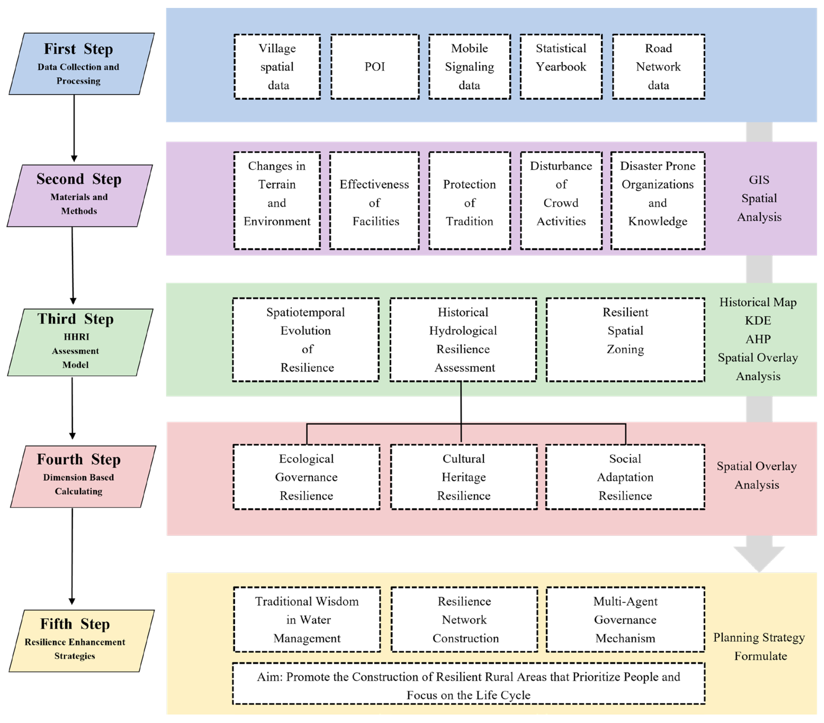
This study constructs a five-stage research framework of “multi-source data collection–historical context analysis–multi-dimensional resilience assessment–systematic problem diagnosis–synergistic enhancement strategy” (Figure 2) for systematic analysis of historical hydrological resilience studies in traditional villages.
Phase 1: Multi-source data collection
Using multi-source historical data fusion methods, a systematic collection of local Chronicles, water conservancy documents, ancient maps, and oral histories was carried out to reconstruct the historical evolution trajectory of the research subjects.
Phase 2: Analysis of historical context
Focus on adaptive practices during key historical periods, including the construction of traditional water conservancy projects, the evolution of social organizational forms and the formation of cultural customs, sort out the evolution of the hydrological environment and adaptive practices in Baoyan Village, and initially explore the formation mechanism and evolution laws of historical resilience.
Phase 3: Multi-dimensional resilience assessment
Based on socio-ecosystem theory, construction includes ecological governance (historical topographic change X1, ecological vegetation coverage X2, natural river channel stability X3, weir field integrity X4, water conservancy facility effectiveness X5), cultural inheritance (historical pattern integrity X6, historical style coordination X7, traditional building protection rate X8), and social adaptation (disturbance of human activities X9, community disaster resistance organization capacity X10). The resilience evaluation index system consists of three dimensions and twelve factors: historical industry adaptability X11 and traditional disaster-bearing knowledge transmission X12. The combined subjective and objective weighting method is used to determine the weights of the indicators, and spatial analysis techniques and mathematical models are employed for quantitative assessment of the resilience level. The spatio-temporal evolution characteristics and changing trends of resilience are quantified through comparative analysis of historical benchmarks and current situations.
Phase 4: System problem diagnosis
Based on the results of the resilience assessment, use the obstacle degree model and correlation analysis methods to identify the key limiting factors and dominant obstructive factors that affect the resilience of the system. In combination with field research and stakeholder interviews, diagnose the root causes of system vulnerability from multiple levels such as ecological degradation, cultural discontinuity, and institutional flaws.
Phase 5: Synergistic enhancement strategies
Propose a three-in-one resilience enhancement path of “ecological governance–cultural inheritance–social adaptation”. Design multi-agent collaborative driving mechanisms, including policy guidance mechanisms, community participation mechanisms, technological innovation mechanisms, and industrial integration mechanisms to ensure the systematicness and sustainability of resilience strategies.

2. Materials and Methods

2.1. Study Area

Zhenjiang is a typical hilly city in the lower reaches of the Yangtze River and one of the first batch of national pilot cities for sponge city construction. It has an excellent infrastructure foundation for urban and rural resilience. This study selects Baoyan Village, a representative traditional Chinese village in Zhenjiang, as the research object to analyze the evolution characteristics and patterns of historical hydrological resilience of Chinese traditional villages. The village has the following characteristics: (1) a long history of waterfront settlements, with the village layout highly integrated with the hydrological environment, and the traditional water network system closely linked to agricultural production and residents’ lives; (2) a well-preserved system of traditional water conservancy facilities, including various types such as weirs, ponds and sluices; (3) a unique hydrological adaptation system of “weir field–river channel–sluice dam” was formed in the hilly water town, which thrived because of water and water transport trade, but was plagued by floods. (4) In the face of typical challenges in the process of modernization, such as the degradation of hydrological systems, the failure of water conservancy facilities, and the disruption of the inheritance of traditional culture, there is an urgent need to conduct systematic research on hydrological resilience (Figure 3).

2.2. Data Sources

The data sources mainly include four aspects:
(1)
Historical document data: Collecting and organizing historical documents such as local Chronicles, water conservancy Chronicles, genealogies, and inscriptions, with a focus on extracting information such as historical hydrological events, water conservancy project construction, and social organization forms;
(2)
Spatial geographic data: including historical maps (1950s), modern remote sensing images (2020–2024), DEM data, land use data, etc., for spatial analysis and evolution studies;
(3)
Socio-economic data: Obtain data on population, economy, industry, etc., through statistical yearbooks, village Chronicles, etc.
(4)
Field research data: Primary information on community perception, traditional knowledge, adaptive behavior, etc. was obtained through participatory observation, semi-structured interviews (n = 35), questionnaires (n = 235), etc.
All data were subject to strict quality control and processing to ensure reliability and comparability. Historical maps are aligned with modern data through geometric correction and coordinate registration, and research data are tested for reliability and validity.

2.3. Research Methods

2.3.1. Construction of an Index System for a Historical Hydrological Resilience Assessment

Study relevant rural resilience assessment models [26,27,28,29,30] and flood disaster assessment models [31,32,33], and construct an evaluation system consisting of three first-level indicators and twelve second-level indicators (Table 1) in combination with the characteristics of water net-like traditional villages [34,35,36]. The weights of the indicators were determined using the AHP-entropy combined weighting method. Firstly, construct the judgment matrix by expert scoring to calculate the subjective weights; subsequently, calculate the entropy weights based on the degree of dispersion of the indicator data; finally, the combined weights are obtained by weighted averaging. After testing, the consistency ratio of the judgment matrix CR = 0.058 < 0.1, which meets the consistency requirement. The weights of the indicators are as follows: ecological governance resilience (0.42), social adaptation resilience (0.35), and cultural inheritance resilience (0.23) (Table 2).
However, cultural inheritance does not merely refer to the survival of material entities; it is a dynamic process of social practice and the reproduction of meaning. When selecting the secondary indicators of cultural heritage resilience, this study has initially considered its dynamic attributes; “X6 historical pattern integrity” not only provides a physical stage for cultural practice, but its spatial form itself also shapes the narrative path of collective memory. “X7 Historical style harmony” reflects the collective choice and aesthetic practice of cultural identity in the development of the community, which is an ongoing consultative process. “X8 Conservation Rate of Traditional buildings” is a key measure of the community’s cultural awareness and inheritance actions.
The “X12 degree of inheritance of traditional disaster-bearing knowledge” in social resilience directly reflects the core of culture as an adaptive knowledge system that is alive through intergenerational learning and everyday practice.

2.3.2. Spatial Analysis and Mathematical Models

By using ArcGIS 10.5 software, the DEM data of Baoyan Village, the historical water system map, and the current land use layout were integrated to construct the historical and current hydrological spatial model. Through spatial superposition analysis, water system changes, elevation changes, and evolution of flood risk areas were identified, and the spatial characteristics of historical hydrological resilience were quantified.
(1) Kernel density analysis method.
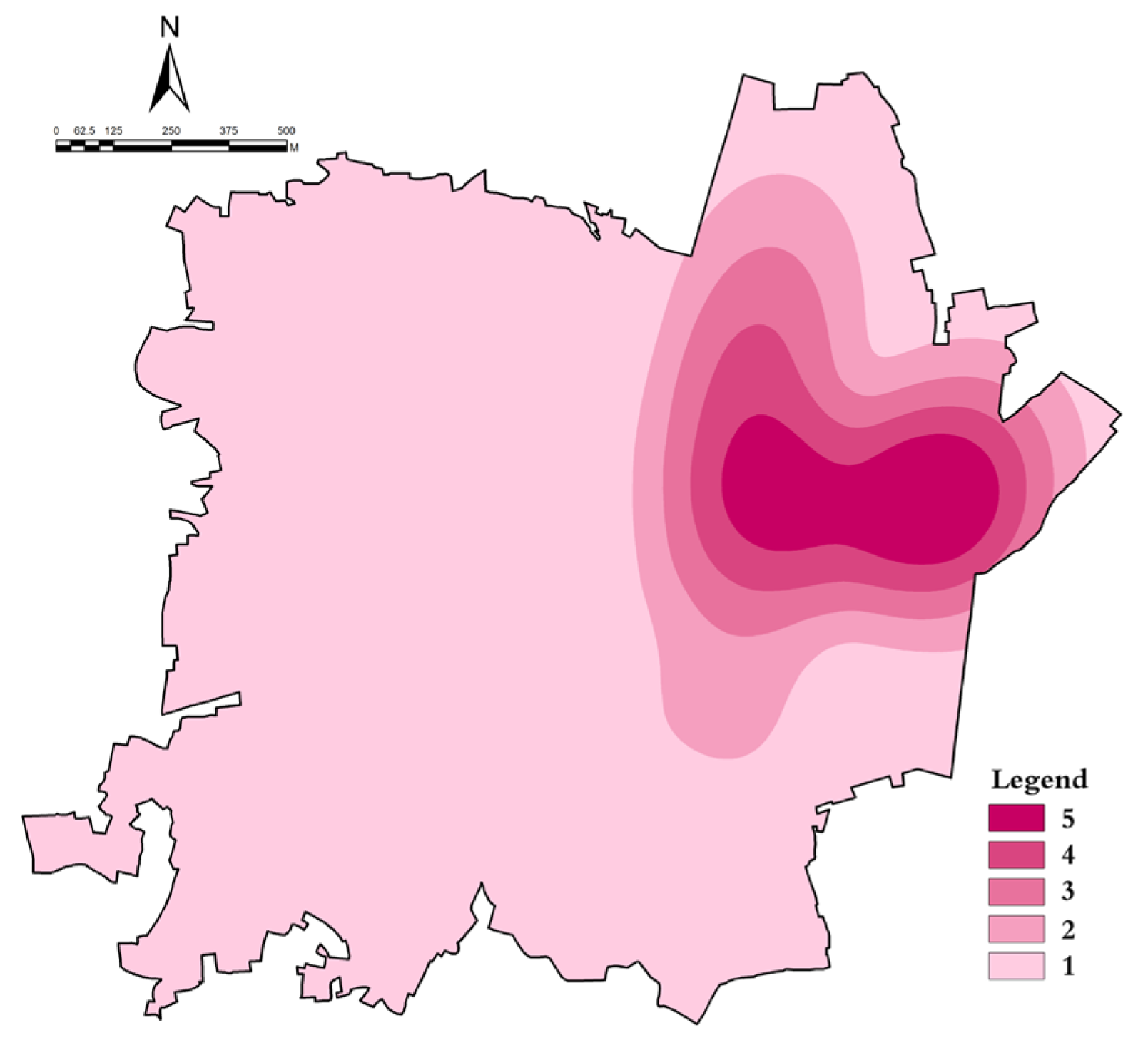
Kernel density analysis is used to estimate the degree of spatial aggregation of geographical events or points, with the core idea being that objects closer to each other have a greater impact on the central point. In this study, we use KDE to visualize the spatial density distribution of population activity in Baoyan Village to identify dispersed and concentrated areas of population aggregation, thereby revealing the level of disaster exposure risk.
The KDE visually presents the density distribution of the village and is used to identify the scattered area and concentrated area of the village crowd gathering. It reveals the changing process of village crowd spatial density and can find regional differences in the overall pattern of village crowd evolution. This paper uses KDE to focus on expressing the spatial agglomeration characteristics of traditional village crowd in Baoyan, and based on this, it extracts the spatial agglomeration pattern of village crowd. The predicted density for the new (x, y) location is determined by the following:
Density   =   1 radius 2 i   =   1 n 3 π pop i 1   -   dist i radius 2 2  
for   dist i   <   radius .
In the formula:
i = 1, …, n is the input point. Only include points in the sum if they are within a radius distance of the (x, y) location.
Popi is the population field value of the I point, and it is an optional parameter.
Disti is the distance between point i and the (x, y) location.
Then multiply the calculated density by the number of points, or the sum of the population field (if any). This correction takes such space quota equal to the number of points (or the sum of the population field) instead of equal to 1. A separate formula needs to be calculated for each location where the density is supposed to be estimated. Since the raster is being created, the calculation will be implemented to the center of each element in the output raster.
(2) Indexation method.
We use the “indexation” method, with a historical baseline of 1.00 (100%), to measure changes in current resilience values. The core of this method is to establish a unified historical benchmark, which enables standardized comparisons of indicators from different periods and different dimensions, thereby clearly and intuitively showing the evolution trends of various resilience indicators since the historical base year. Rstandardized: normalized toughness value. Xcurrent: the current indicator value to be evaluated. Xbase: selected historical benchmark indicator value. This value is defined as the benchmark, and the standardized value is 1.
R standardized = X current / X base
In the formula, such as Rstandardized = 1, it indicates that the current indicator is equivalent to the historical benchmark level. R > standardized1 indicates that the current indicator is better than the historical benchmark. The larger the value, the more resilient it is. R < 1 indicates that the current indicator is worse than the historical benchmark. The smaller the value, the less resilient.
(3) Toughness index weight calculation.
The calculation of index weights is a key step in the comprehensive evaluation. In order to balance the subjective experience of experts in the resilience domain (Analytic Hierarchy Process, AHP) with the objective information volume of the indicator data itself (entropy weight method), this paper adopts a combined weighting method. This approach aims to balance subjective judgment with objective data, so that the final weight distribution is both in line with professional cognition and reflects the intrinsic structure of the data. Firstly, a well-defined evaluation index system for the hydrological resilience of traditional villages is established through the AHP method. Secondly, based on the indicators at the upper level, construct a comparison judgment matrix, conduct consistency tests, and determine the weights of each indicator. Finally, the detailed index weights of the evaluation index system for hydrological resilience of traditional villages were obtained by cumulative synthesis layer by layer through the weighting method. For detailed steps, see relevant reference [37]. The entropy weight method determines the index weights based on the degree of variation of each index under objective conditions. The weights of each indicator in the traditional village hydrological resilience evaluation index system are calculated by determining the entropy value. For detailed steps, see relevant reference [35]. In this paper, the weights were determined based on the analytic hierarchy process and the entropy weight method, and there was no bias. Therefore, the preference coefficient was used to calculate the indicators and determine the final weights as follows:
W j = μ L j + ( 1 μ ) Q j
In the formula: In the formula: j is the first evaluation index; Qj is the weight of the item as calculated using the Analytic Hierarchy Process; Lj is the weight of the first indicator calculated by entropy weight method; Wj is the final weight of the indicator after the combined weighting. The coefficient μ (0 ≤ μ ≤ 1) represents the degree of preference for the subjective and objective weights. In this study, we set μ = 0.5, giving equal importance to both methods to avoid bias.
(4) Obstacle degree model.
The obstacle degree model is used for diagnostic analysis. It helps identify which specific factors are the main obstacles to the improvement of the overall historical hydrological resilience system. This diagnostic analysis enables us to move from an overall assessment to targeted strategy formulation. By analyzing the degree of obstacles, targeted measures can be proposed for future resilience improvement, as shown in Equation (4):
C ij = w j   ×   ( 1     X i j ) j   =   1 n w j   ×   ( 1     X i j )
In the formula: Ci is the obstacle degree of the i-th indicator; wj is the weight of the indicator; Xi is the standardized value of the metric. (1−Xij) effectively measures the “gap” between the current state and the optimal state (1.00), ensuring that the underperforming indicators contribute more to the obstacle level.

3. Case Study: Historical Hydrological Resilience in Baoyan Village

3.1. Formation and Evolution of Historical Hydrological Resilience

(1) Ancient: The Adaptive Foundation of Water (Ming and Qing periods).
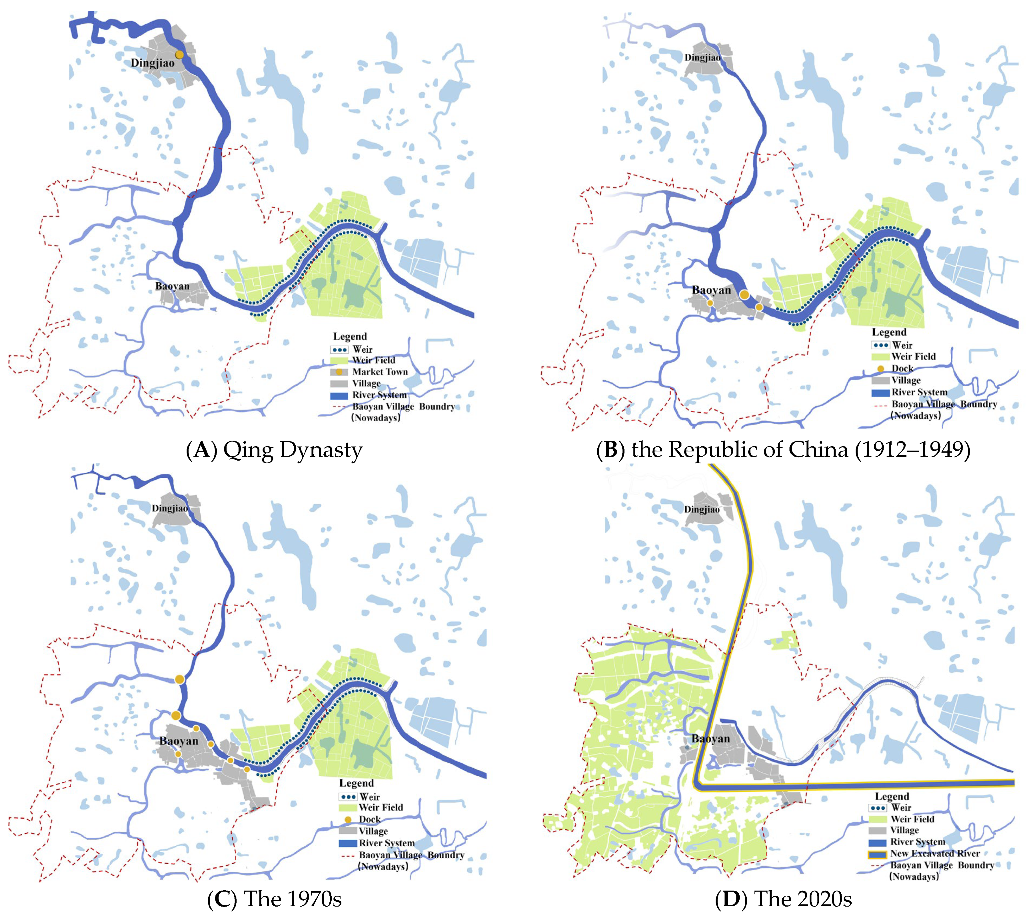
Before the Ming Dynasty, there were frequent floods in the Baoyan area, and settlements were scattered in the highlands. At the end of the Ming Dynasty and the beginning of the Qing Dynasty, people built weirs to hold back floods and “regarded the weirs as treasures”, and named them Baoyan. During the reign of Emperor Qianlong of the Qing Dynasty, the Dingjiao section of the Tongji River silted up, and Baoyan, taking advantage of its wharf status, replaced Dingjiao as a major commercial port town, forming a spatial pattern of “trading along the water”. During this period, a preliminary flood control and irrigation system was formed through “building weirs–opening canals–digging ponds”, such as the construction of Taiping Bridge (Sanxian Bridge), which connected the two banks and strengthened the function of commercial distribution (Figure 4A).
(2) Modern Times: Enhanced Resilience of Engineering and Institutions (Republic of China period).
During the Republic of China era, Baoyan was prosperous in business, with hundreds of large and small shops and four major docks along the Tongji River. To deal with floods, the Xiaohe North Gate and Huangguan River Gate were built in 1933, forming an engineering system of “sluice and dam flood control”. At the same time, local gentry Li Yuchun and others donated money to dredge the river and build stone bridges, forming a water management system of “government guidance–gentry participation”, which enhanced the system’s ability to deal with extreme rainfall (Figure 4B).
(3) Modern: Water System Transformation and Resilience Transition (After the Founding of the Country).
After 1949, large-scale water conservancy projects were carried out in Baoyan. In the 1970s, the diversion of the Tongji River and the widening of the Shengli River were implemented, which completely changed the water system pattern and brought the flood under control, but also led to the drying up of the old Tongji River and the disintegration of the traditional water network. During this period, hydrological resilience shifted from “adapting to nature” to “transforming nature”, and engineering resilience improved significantly, but ecological and social resilience weakened (Figure 4C).
(4) Contemporary Challenges and Resilience Decline (2000 to present).
Entering the 21st century, the rapid urbanization process and the impact of climate change have overlapped, presenting new challenges to Baoyan Village. Remote sensing monitoring data shows that the current water surface rate has dropped by 37% compared to 1950. The abandonment rate of traditional water conservancy facilities is as high as 68%, and the enthusiasm of communities to participate in water governance has significantly declined. The hydrological resilience of this period is characterized by a triple dilemma of aging engineering facilities, degraded ecosystems, and insufficient social participation, which urgently requires systematic measures to enhance the overall resilience level (Figure 4D).

3.2. Resilience Assessment

3.2.1. Historical Hydrological Resilience Assessment

(1) Dimensions of ecological governance resilience.
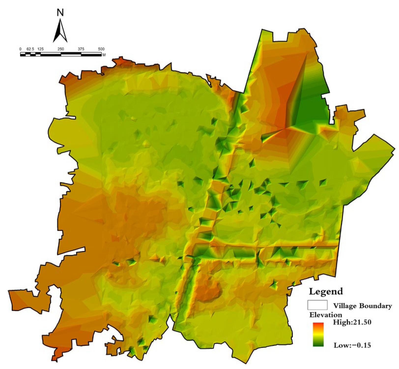
Based on GIS spatial analysis technology, the ecological governance resilience of Baoyan Village was quantitatively evaluated. Firstly, an elevation distribution map was generated using DEM data (Figure 5). The results showed that 85% of the core area of the village was below 10 m in altitude, which was a flood-prone area. This was in good agreement with the historical topography and geomorphology, with an agreement degree of 91%, indicating a low degree of historical topography variation (X1).
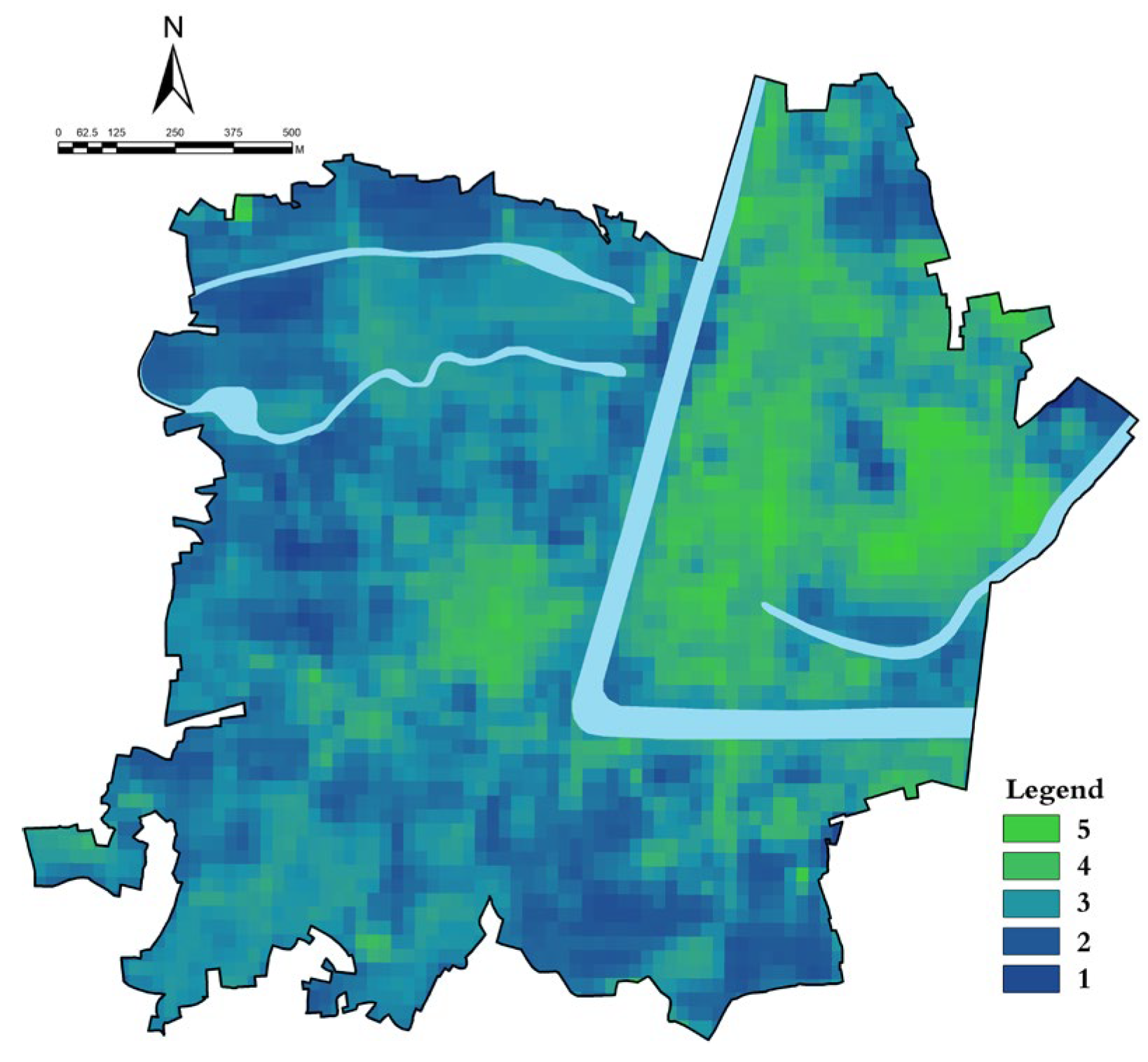
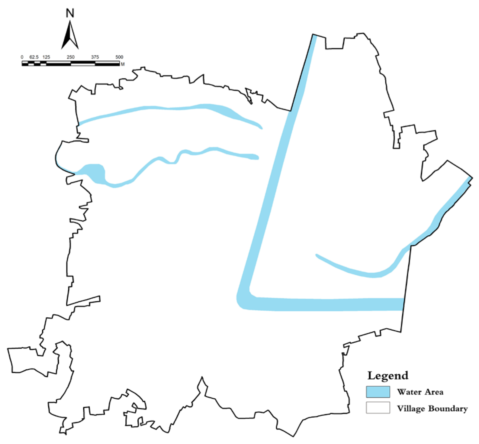
NDVI vegetation index analysis (Figure 6) showed a significant positive correlation between vegetation coverage and hydrological resilience. The NDVI value in the northern hilly area was 0.6–0.8, while in the town core area it was only 0.2–0.3, indicating a significant degradation of the vegetation index and a marked insufficiency of ecological regulation capacity (X2). The water system analysis (Figure 7) was similar, with 60% of the historical river channels silted up or disappeared, reducing the ecological regulation capacity (X3).
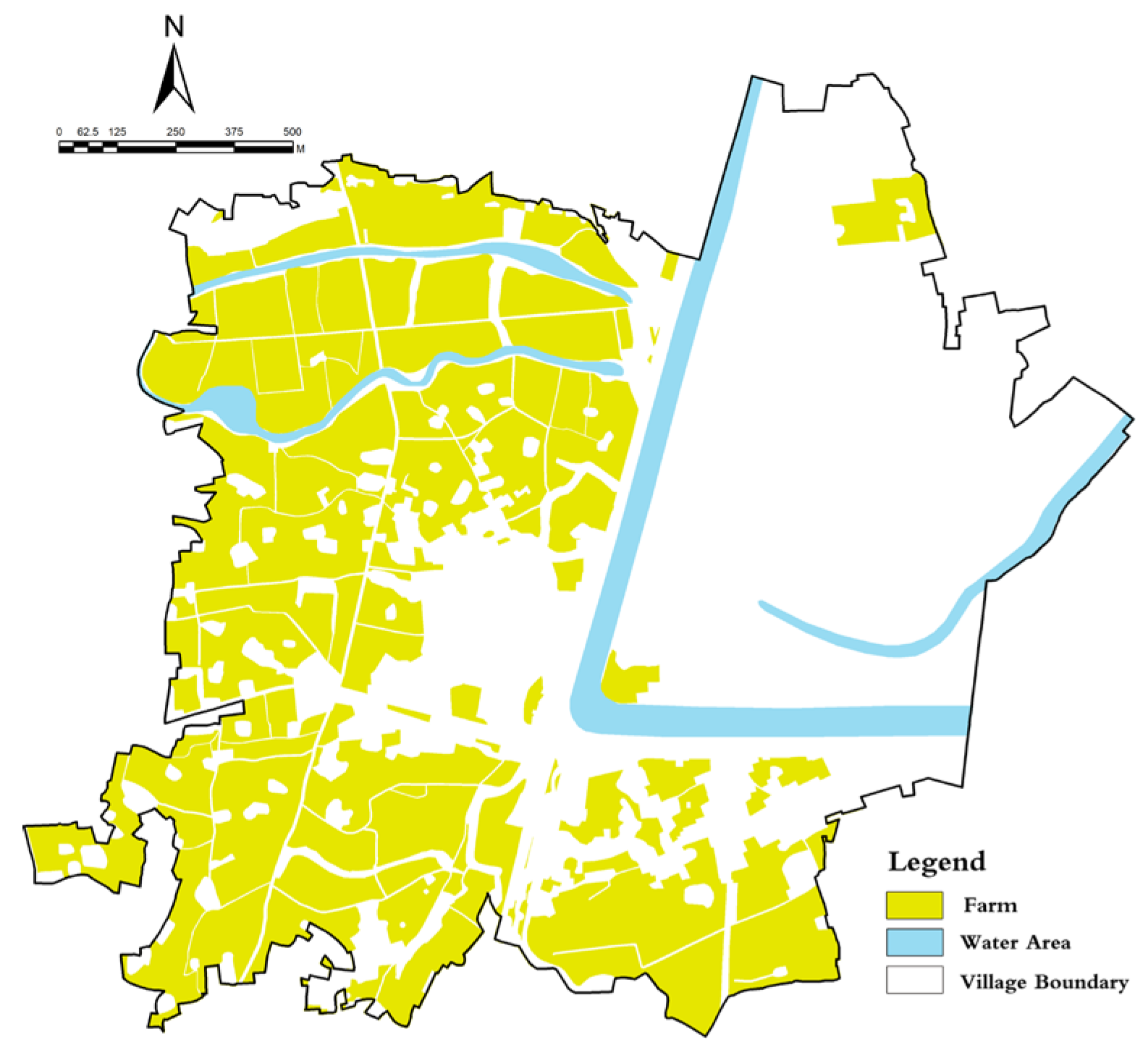
The analysis of farmland distribution (Figure 8) shows that the weir field historically located in the eastern part of the study area have disappeared, but new basic farmland has been built in the western part of the study area due to the improvement of water conservancy facilities, which has enabled agricultural production in the originally low-altitude area and maintained the ecological regulation capacity of the area (X4).
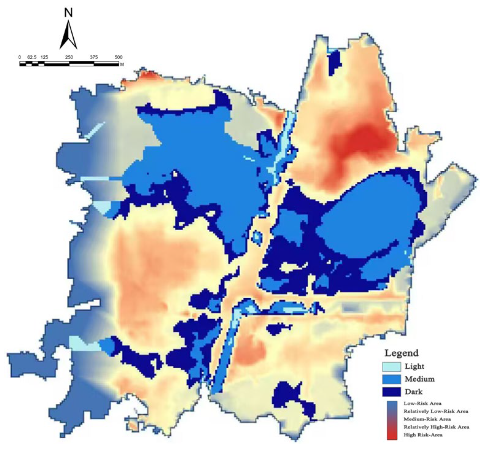
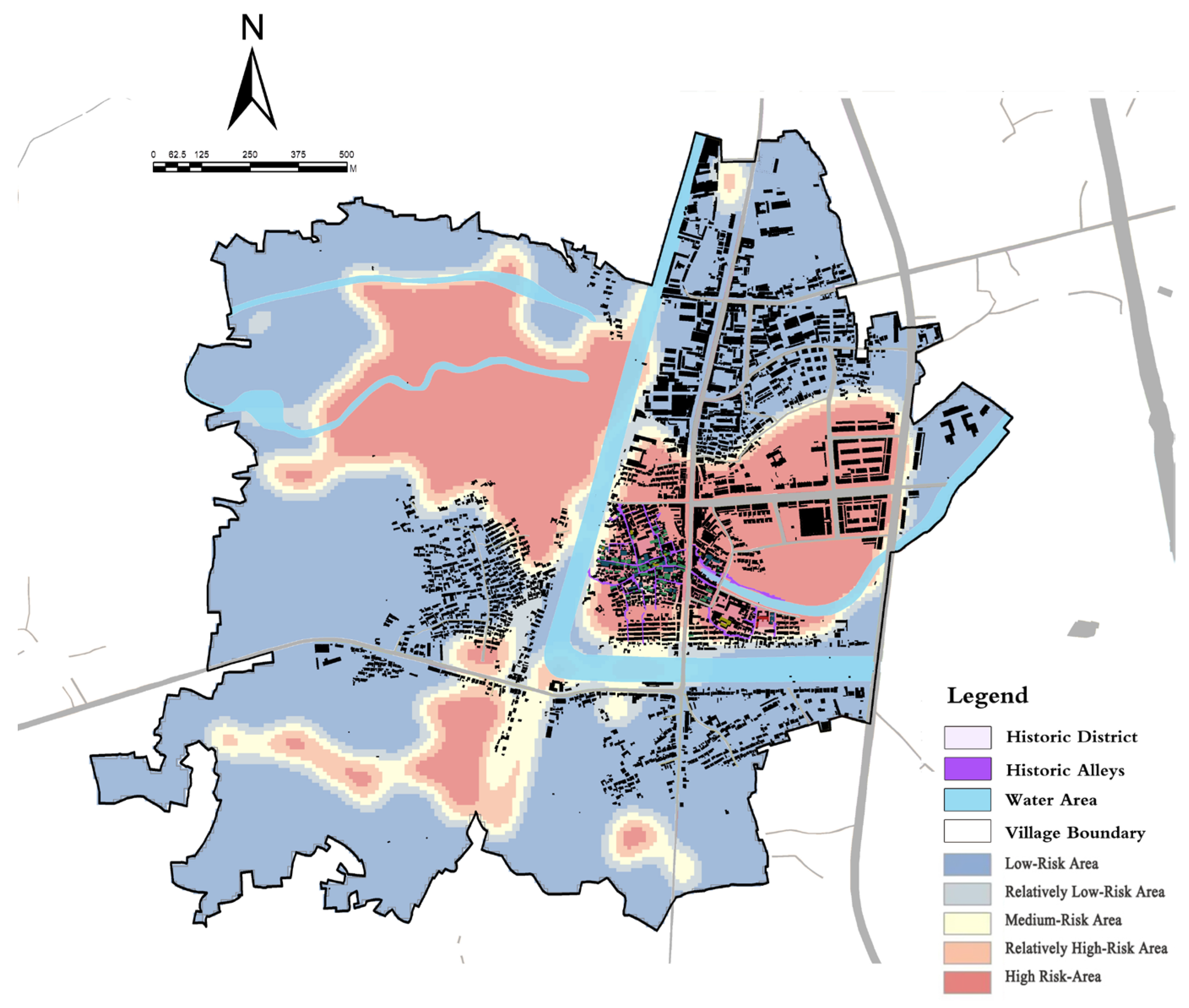
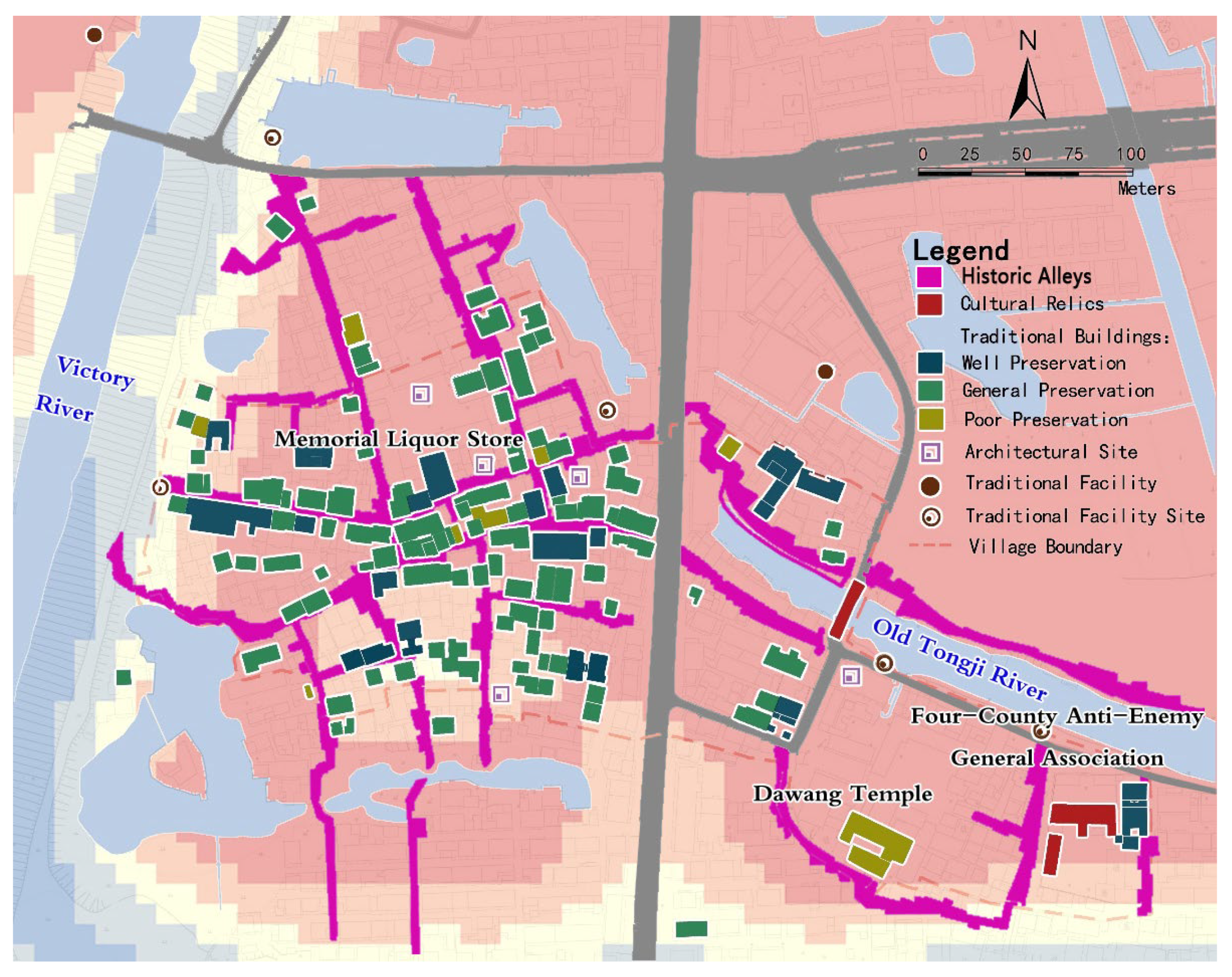
The flood inundation range map (Figure 9) and the inundation depth map (Figure 19) were drawn through hydrological model simulation analysis. When the inundation height reached 25.38 m, the area of the high-risk zone accounted for 12.7% of the entire town, mainly concentrated in the historical town area along the old Tongji River. Based on GIS spatial overlay analysis, the area of the high-risk zone was 10.9 hectares, accounting for 12.7% of the total study area, mainly concentrated along the old Tongji River, with an average elevation of 6.8 ± 1.2 m, significantly lower than the town average (9.4 ± 2.1 m) (p < 0.01), indicating a significant improvement in the effectiveness of water conservancy facilities in the study area. The historical flood control pattern has been changed (X5).
(2) Dimension of cultural heritage resilience.
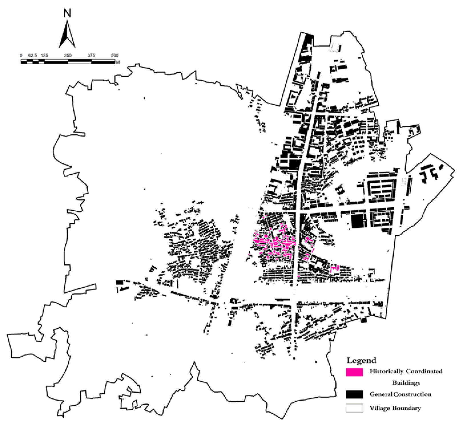
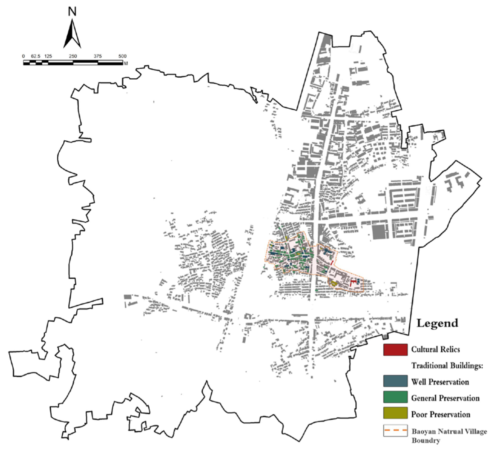
The assessment of cultural heritage resilience uses a combination of field research and literature analysis. The findings are as follows (Figure 10, Figure 11 and Figure 12):
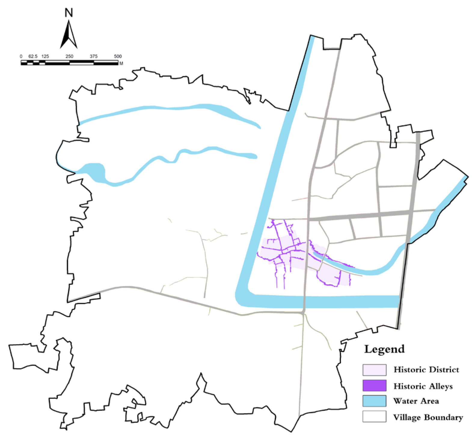
The analysis of the integrity of the historical pattern (X6) shows that 64% of the historical streets and alleys in the study area have been preserved, and the historical pattern has been basically maintained intact.
The historical style coordination (X7) analysis indicated that the proportion of historically style-coordinated buildings was only 35%, and the task of style-coordination was arduous.
The analysis of the distribution of historical buildings (X8) shows that 39 percent of historical buildings have been preserved, and the resilience of cultural heritage faces severe challenges.
(3) Dimensions of social adaptation resilience.
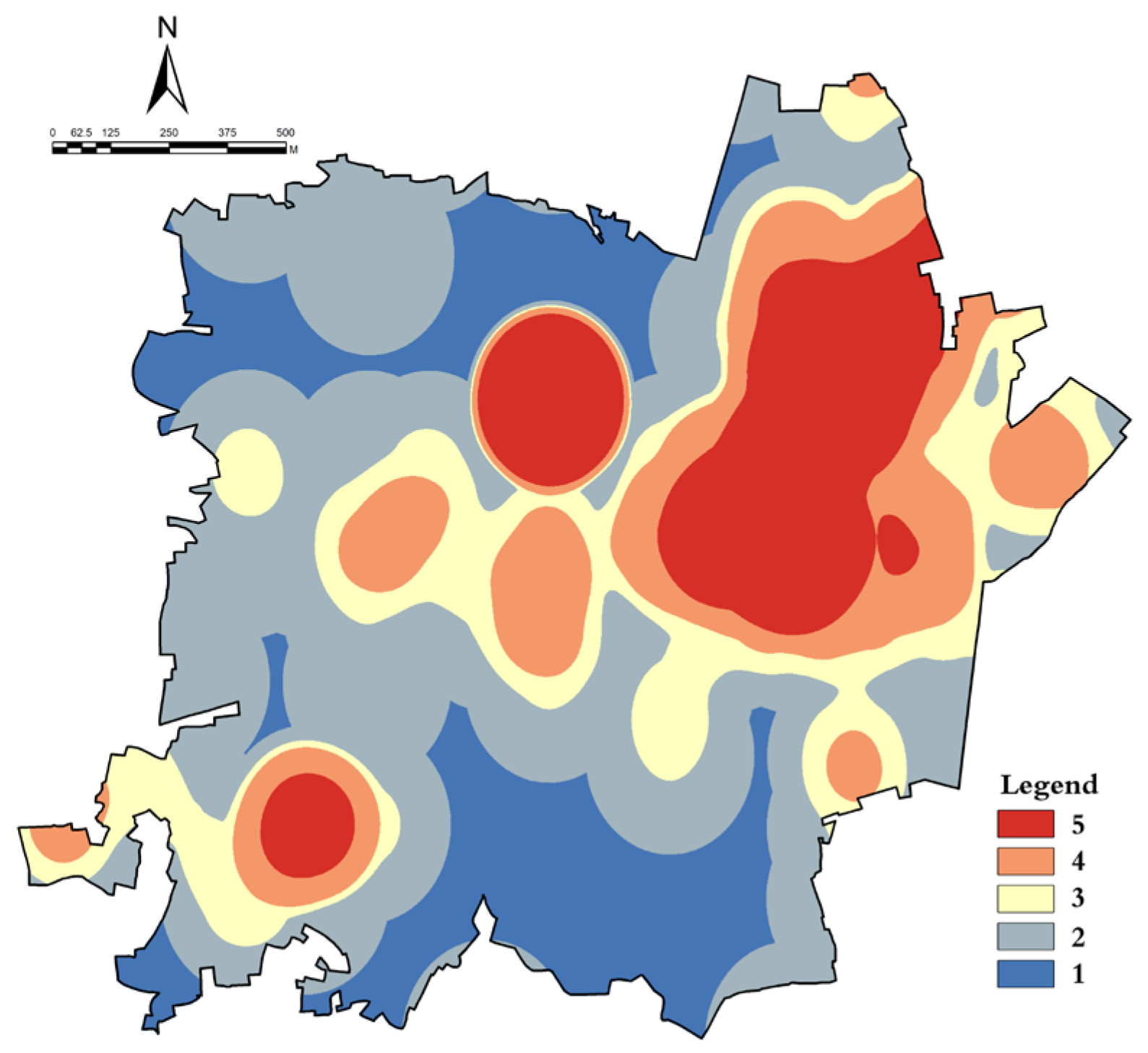
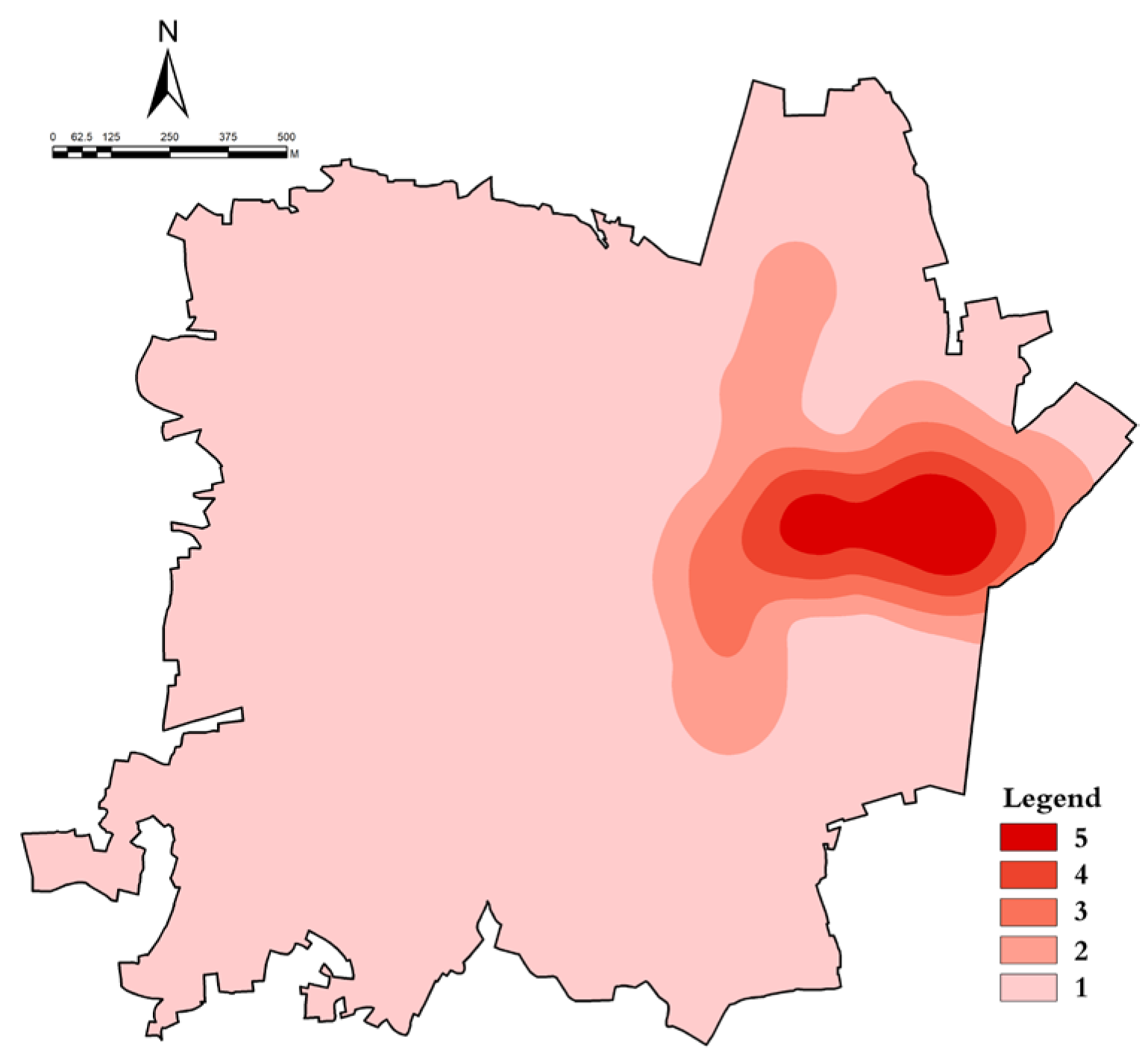
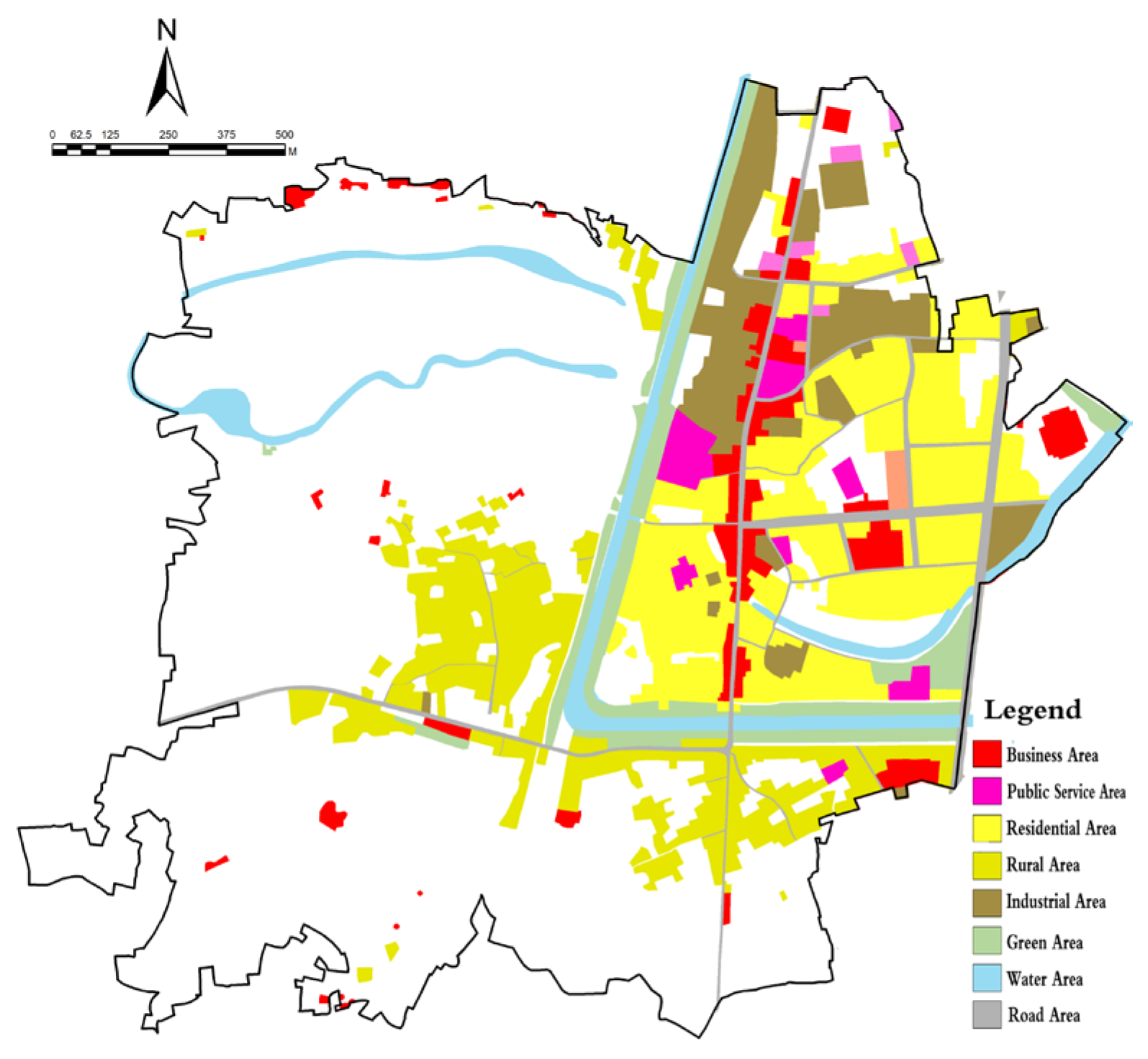
Social resilience assessment uses a multi-source data fusion approach [39]. Firstly, the spatial distribution of morning population activity in the study area (X9) was quantified through population activity kernel density analysis (Figure 13). The results showed that the population was highly concentrated in the historic town area, with a peak daytime population density of 125 people per hectare, far exceeding the surrounding areas, increasing disaster exposure and disaster risk in the area.
Secondly, through an analysis of land use nature and a comparative survey of ancient and modern business types, it was found that only 26% of the traditional industries or business types in the study area have survived, which also makes it difficult to absorb residents to engage in traditional industries, resulting in an accelerated outflow of population and reduced social resilience.
Thirdly, the community questionnaire survey (n = 235) shows that the community has sufficient disaster resistance material reserves and a resilient disaster resistance organizational structure (Figure 14, Figure 15 and Figure 16). The majority of residents are willing to participate in the community flood prevention activities, reflecting the strong disaster resistance organizational capacity (X10-11) of the community and the improvement of social resilience. Traditional disaster-bearing knowledge (X12) is mainly held by people aged 65 and above, accounting for only 28%, while young people and middle-aged people generally say they have no knowledge of traditional disaster-bearing knowledge.
(4) Comprehensive Evaluation of Historical Hydrological Resilience (HHRI).
As described in Section 2.3, a model for evaluating the historical hydrological resilience of Baoyan Village was constructed based on the Delphi method and the analytic hierarchy process, and the weights of each dimension were determined as 42% for ecological governance resilience, 35% for social adaptation resilience, and 23% for cultural inheritance resilience.
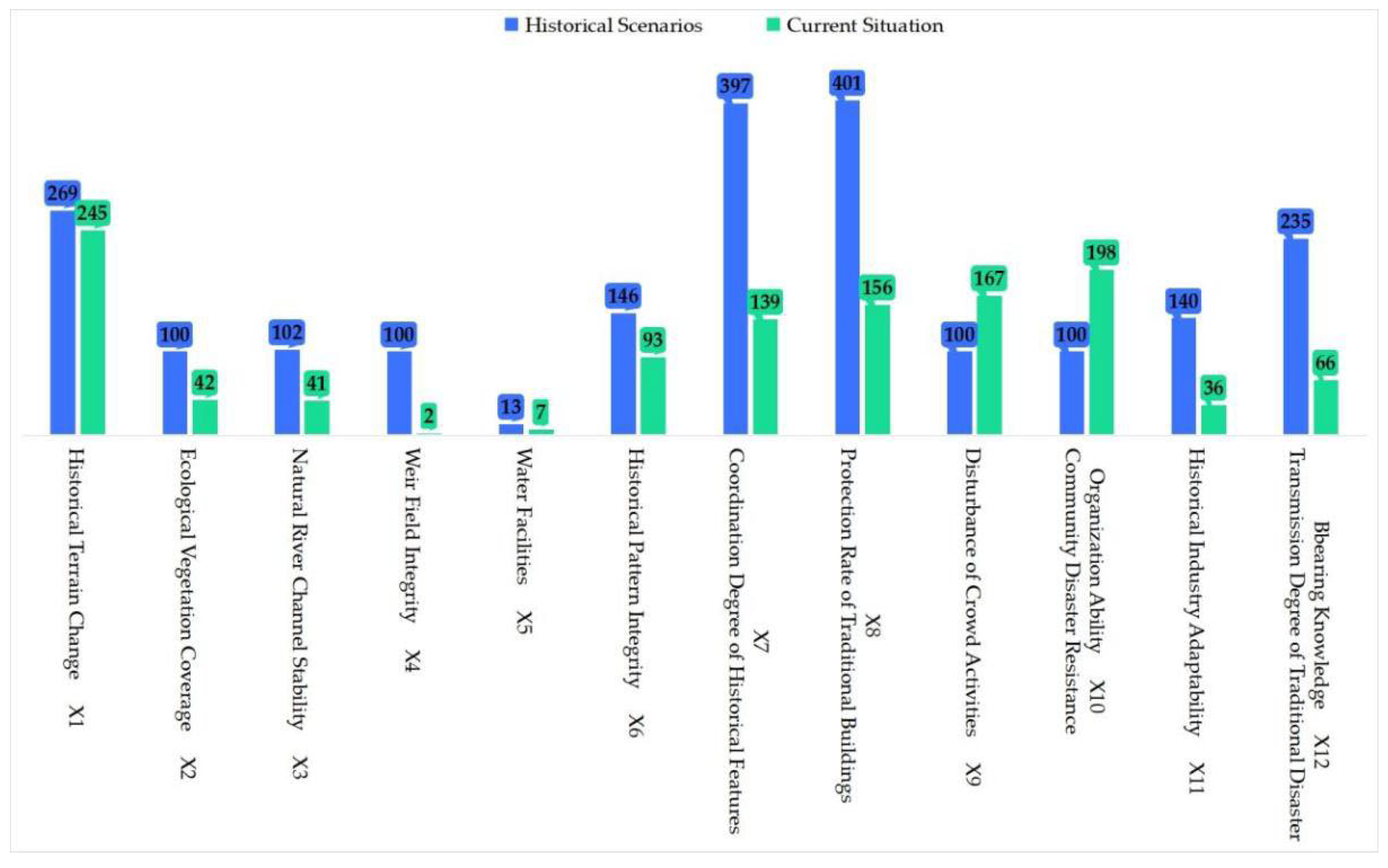
The historical scenario resilience indicators were set at 1.00, and the current situation resilience indicators were standardized. The comprehensive evaluation results (Figure 17) showed that the Ecological Governance Resilience score was 0.48. The Cultural Heritage Resilience score was 0.46, and the Social Adaptation Resilience score was 1.05 (Table 3). The total score after weighted evaluation was 0.6746. This indicates that the overall HHRI of Baoyan Village has declined, with more declines in ecological governance and cultural heritage resilience. However, in the dimension of social adaptation resilience, it has even increased compared to historical scenarios. This is due to the improvement of water conservancy infrastructure and the level of community organization guarantee, which has enhanced the village’s ability to withstand flood disasters.
The results of the obstacle index calculation show that the top three obstacle indices are X4, X12, and X3, indicating that the integrity of the weir field, the transmission of traditional disaster prevention knowledge, and the stability of the natural river channel are the main factors hindering the improvement of the resilience system (Table 4). Planning should focus on these indicators and formulate relevant strategies for improvement.

3.2.2. Resilience Assessment Results

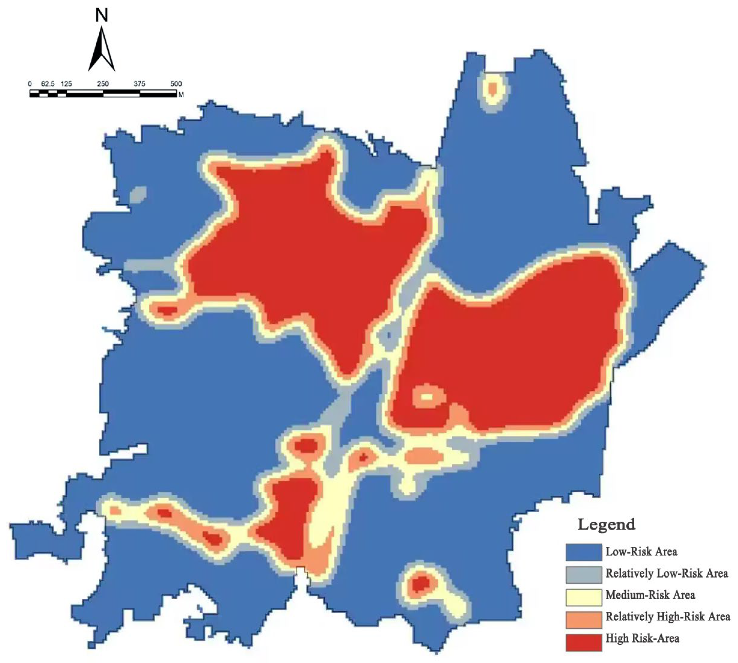
The rain and flood resilience of Baoyan Village is classified into five levels through GIS overlay analysis (Figure 18):
Flood inundation risk level map of Baoyan: The map is divided into low-risk area, lower-risk area, medium-risk area, higher-risk area, and high-risk area. The very high-risk area accounted for 12.7% (10.9 ha), the high-risk area accounted for 26.5% (22.7 ha), the medium-resilience area accounted for 30.6% (26.3 ha), the low-risk area accounted for 20.5% (17.6 ha), and the extremely high resilience area accounted for 9.7% (8.3 ha). When the inundation height reaches 25.38 m, the high-risk area indicates a high risk of flood threat, with a high likelihood and severity of flood inundation. Low-risk areas are less likely to be affected by floods.
Extremely high-risk area (12.7%): Concentrated in the historic town area along the old Tongji River, with high building density and severely fragmented water systems. There are 3.4 hectares of areas with inundation depth of more than 1.5 m, accounting for 18.6 percent of the built-up area of the town.
High-risk area (26.5%): Includes farmland on both sides of the Victory River and some new villages, with poor drainage problems.
Medium-resilient area (30.6%): located at the junction of the weir field system and modern water conservancy facilities.
Low-risk area (20.5%): Mainly northern hilly forested areas with strong natural storage capacity.
High-resilience area (9.7%): Concentrated around the New Fourth Army site in Qianhuang Village, maintaining high resilience due to strict ecological protection.
This spatial differentiation pattern profoundly reflects the combined impact of historical development and modern construction activities on hydrological resilience, providing a scientific basis for the formulation of subsequent resilience enhancement strategies.

4. Discussion

Based on the aforementioned systematic diagnosis of the spatio-temporal evolution and multi-dimensional assessment of historical hydrological resilience in Baoyan Village, this chapter aims to construct a systematic resilience enhancement framework that integrates engineering intervention, ecological restoration, social reconstruction, and cultural activation, and to clarify its multi-subject collaborative implementation mechanism.

4.1. Modern Translation and Technological Innovation of Traditional Water Management Wisdom

The core of the historical resilience mechanism lies in the multi-level redundant regulation and storage system composed of “sluice–weir–pond”. Its modern translation is not a simple restoration, but rather a coupling of historical wisdom with contemporary demands through appropriate technological innovations.

4.1.1. Adaptive Engineering Restoration and Intelligent Empowerment

For the core vulnerable areas, the top priority is to restore the structural functions of the historical water system and enhance its intelligent monitoring level. The Taiping Bridge–Sanxian Bridge, a historically critical river section, is chosen for priority intervention. Restoration was carried out using a composite technique of “granite dry masonry and ecological slope protection”. The technique is not a simple imitation of the ancient—dry masonry restores the traditional infiltration and energy dissipation functions, while ecological slope protection enhances the stability and biodiversity of the slope by planting native plants with well-developed root systems, such as willow and reed, achieving an organic combination of traditional forms and modern ecological engineering. Miniature water level, flow velocity, and stress sensors are embedded in the restored structure to build Internet of Things monitoring nodes. Data is transmitted in real time to the village-level management platform for continuous performance monitoring and early risk warning of historical facility operation status, transforming passive maintenance into predictive care.

4.1.2. Adaptive Reuse of Hydraulic Heritage and Immersive Education

Transforming abandoned water conservancy facilities into carriers of cultural resilience, such as transforming the Republic of China Huangguan River Sluice into the “Baoyan Hydrological Resilience Exhibition Hall”. During the renovation, the structure and historical traces of the gate were fully preserved, and augmented reality (AR) technology was used inside to recreate the historical scenes and water management wisdom when the gate was built in 1933. Another example is the development of immersive interactive exhibits that allow visitors to experience the effect of opening and closing the gates on regulating water levels through virtual operations, transforming water conservancy facilities from static viewing objects into dynamic knowledge media, greatly enhancing the flood prevention awareness and cultural identity of the community and visitors (Table 5, Figure 19 and Figure 20).

4.2. Construction of Resilient Networks for Ecological–Cultural Synergy

4.2.1. Shengli River Ecological Buffer Zone: Nature-Based Solutions (NbS)

This zone is designed to restore the river’s natural processes and enhance its ecological purification and flood detention capacity. A 20–50 m-wide buffer zone is built along the river, with stepwise planting of native aquatic and hydrophytic plants such as reeds, calamus, and lythrum salicaria. These plants not only have excellent water purification capabilities, but their dense root systems can also effectively stabilize soil, protect slopes, and slow down the flow of water.

4.2.2. Terraced Landscape Belt: A Fusion of Production, Ecology and Experience

This zone promotes the multi-functional transformation of the weir field agricultural system. It integrates traditional farming experience zones, rain garden demonstration sites, and eco-study paths, and introduces the “Weir Field Adoption” program to attract citizens and businesses to adopt plots. Adopters not only receive the produce but also participate in simple maintenance work, transforming it into a paid distributed maintenance force, achieving a social innovation in the sustainable operation and maintenance of disaster prevention facilities.

4.3. Innovation in Multi-Party Governance and Long-Term Operation Mechanism

The sustainability of resilience improvement lies in the innovation of governance models, which requires the establishment of a four-party synergy driving mechanism of “government–experts–community–market”.

4.3.1. Community Capacity Building and Endogenous Driving Force Cultivation

Establish a “water lane manager” system. Train a number of local villagers systematically to become grassroots forces in resilience building. The training covered traditional knowledge, inspection skills, equipment operation, etc. After being certified, they were responsible for the daily inspection, simple maintenance, and knowledge explanation of the water system, and the government subsidized their labor through public welfare positions.
Refine the participatory planning workshop. Organize resilience planning workshops before major project decisions, using 3D models and simple simulation tools to give villagers an intuitive understanding of the impact of the plan, and incorporate their feedback into the final design to ensure the local suitability and acceptability of the strategy.

4.3.2. Market-Based Risk Sharing and Sustainable Financing

Resilient insurance products. Collaborate with insurance companies to develop “heritage and flood prevention” combined insurance products. The product bundles traditional property insurance with funds for the protection and restoration of cultural heritage. For farmers who actively participate in resilience enhancement measures such as roof rainwater collection and courtyard permeable renovations, significant premium subsidies are given to create a positive incentive cycle of “resilience behavior–risk reduction–premium discount”.
Resilience value conversion. Combine the enhanced resilient environment with the rain and flood culture experience industry. Develop tourism products such as “flood control study tours” and “ecological bird watching”, convert disaster prevention investments into operational assets, and use part of the proceeds to support the continuous operation of the community resilience fund.

4.3.3. Digital Governance Platform and Smart Decision-Making

Digital twin systems. Build a village-level digital twin platform based on BIM + GIS technology, integrating real-time monitoring data, historical disaster situation, and population and economic data. The platform can simulate rainstorm scenarios and conduct inundation analysis to provide decision support for emergency evacuation.
Crowd activity monitoring system and public interface development. Through mobile phone signaling technology, a crowd activity monitoring and early warning system was established in Baoyan Village, and real-time analysis of crowd activities in the village was conducted. Early warnings were issued as soon as there was an abnormal disturbance of the crowd (Figure 21). Connect to the villagers’ mobile phone application to open functions such as water situation warning, evacuation route navigation, and problem reporting. This not only safeguards villagers’ right to know and participate, but also transforms it into a vast network of mass monitoring and prevention sensors, greatly enhancing the efficiency of emergency response.

4.4. The Dynamic Nature of Cultural Resilience: A Social Anthropological Perspective

The assessment results of this study reveal that cultural inheritance resilience is one of the dimensions with the most severe decline in the hydrological resilience system of Baoyan Village. To gain a deeper understanding of this phenomenon and propose more fundamental activation strategies, it is necessary to go beyond the perspective of viewing culture as a static “variable” and instead interpret it from the perspective of social anthropology as a dynamic “social process” embedded in daily life. This is mainly reflected in the following three aspects:
(1) The “embodied” inheritance and fragmentation of traditional knowledge.
Social anthropology emphasizes that knowledge is not an abstract symbol but is passed down through “embodied” practices. The traditional disaster knowledge of Baoyan Village (such as predicting the weather by observing clouds and animal behavior, or determining the timing of opening and closing gates based on the speed of water flow) was originally embedded in the work, narratives, and daily rituals of the elders and was a kind of “bodily memory” and “tacit knowledge”. The questionnaire shows that the inheritance rate of this knowledge is only 28% and it is concentrated among people over 65 years old, which not only means the loss of information, but also marks the disintegration of the intergenerational “community of practice”. The younger generation’s disengagement from agricultural production and river management has deprived the transmission of knowledge of the necessary physical practice and social context, leading to the “deskillization” of cultural adaptability.
(2) The ritualization of water management practice and its social integration function.
In traditional villages, water conservancy activities often go beyond the technical realm and have profound social and cultural functions. The historical model of “government guidance and gentleman participation” in water governance, as well as public activities such as collective dredging and construction of dams and weirs, can be regarded as a kind of “ritualized” social practice. They not only maintained water facilities, but also strengthened community identity, trust, and collective action capacity—that is, social capital—through periodic collaboration. Modern engineered governance, which turns water management into the responsibility of specialized departments, while enhancing efficiency, has invisibly weakened the cultural rituals that bring communities together, leading to the loss of social capital and a decline in community participation enthusiasm, which is the cultural root of the potential crisis in the sustainability of social resilience, which scores high at the organizational level.
(3) The reconstruction of the “narrative” of local identity and resilience empowerment.
The core of cultural resilience lies in the sustainability of local identity. The history of Baoyan Village, which thrived because of the weir, forms the core narrative of the community about “coexistence of man and water”. This positive identity narrative is challenged when the water system deteriorates and related knowledge and practice wane. The strategies proposed in this study, such as transforming the Huangguan River sluice into a hydrological resilience exhibition hall and developing “flood control study tours”, are essentially initiating a new round of “narrative reconstruction”. Recreating historical scenes through AR technology or allowing visitors to experience gate control in a virtual operation are measures that transform traditional wisdom from a dusty memory into an experiential, valuable local brand. This process not only educates outsiders but, more importantly, reshapes the perception of the value of their own culture among the residents of the community, thus transforming culture from a protected “heritage” into a “capital” that drives endogenous development and proactively adapts to the future.

4.5. Comparisons and Insights from an International Perspective

The “ecological–culture–social” resilience imbalance in Baoyan Village, as revealed in this study, is not an isolated case but a common challenge faced by traditional settlements around the world in the process of modernization. However, the specific manifestations and solutions vary depending on the regional cultural and socio-economic background.
By comparing the above table, we can draw the following three key implications for resilience building in Baoyan Village and other traditional villages in China:
Paradigm shift from confrontation to symbiosis: Both Japan’s “symbiosis” philosophy and Venice’s “adaptive reuse” point to a shift from the engineering paradigm of “opposing nature” to the ecological cultural paradigm of “coexistence with water and all things”. The strategy of “ecological space reconstruction” in Baoyan Village reflects this direction, and in the future, water systems need to be more thoroughly regarded as a community of life rather than an object of management.
Institutionalization and refinement of governance models: The experience of the Netherlands in institutionalizing public participation suggests that while establishing community participation mechanisms such as “water lane managers”, we need to be accompanied by clear definitions of rights and responsibilities, stable financial support, and legal guarantees to avoid them being formalistic, so as to truly cultivate endogenous, institutionalized governance capabilities.
Creative transformation of Cultural capital: Venice’s approach of turning the flood challenge into a tourist attraction is highly instructive. The development of the “rain and flood cultural experience industry” in Baoyan Village is an effective attempt to transform the passive cultural memory of “enduring disasters” into the active cultural and economic capital of “resilience”, and is a key path to achieving sustainable development of resilience construction.
In summary, the case of Baoyan Village not only validates the universal law of global traditional settlements’ hydrological resilience construction, that is, the path of social–ecology–culture integration must be adopted, but it also contributes unique Chinese wisdom such as, in the context of rapid urbanization, through “modern translation of historical wisdom” and “coordinated drive of multiple subjects” to achieve the restoration and leap of resilience systems. This “Baoyan model” provides a valuable reference for historical settlements in East Asia and around the world facing similar development pressures.

5. Conclusions

5.1. Core Findings of the Case Study

This study takes Baoyan Village in Zhenjiang City, Jiangsu Province as a typical case and conducts a systematic diagnosis of its human settlement environment by constructing an assessment framework of “historical hydrological resilience”. The main findings are as follows:
(1)
Resilience assessment and spatio-temporal differentiation characteristics: The comprehensive index of historical hydrological resilience (HHRI) of Baoyan Village is 0.67, showing an overall downward trend compared to the historical benchmark. The spatial pattern shows a significant differentiation of “core vulnerability–marginal resilience”, with high-risk areas (12.7%) highly concentrated in the historic town area along the old Tongji River, which is also a densely populated area of cultural heritage, revealing the common challenges faced by flood safety and cultural protection.
(2)
Multi-dimensional resilience evolution and imbalance: There are obvious dimensional differences in the decline of resilience. Among them, ecological governance resilience (0.48) and cultural heritage resilience (0.46) declined most severely, while social adaptation resilience (1.05) increased due to the improvement of modern water conservancy facilities and community organization. This indicates that Baoyan Village is facing a complex situation where “ecological–cultural” resilience is waning and “social–engineering” resilience is increasing.
(3)
Identification of key obstacle factors: The diagnosis of the obstacle degree model indicates that the integrity of the weir field (X4), the transmission of traditional disaster knowledge (X12), and the stability of the natural river channel (X3) are the three core obstacle factors restricting the improvement of hydrological resilience in Baoyan Village.
(4)
Feasibility verification of resilience enhancement pathways: Based on the above diagnoses, this study proposed and preliminarily verified the synergistic enhancement pathways of “ecological space reconstruction–activation of traditional water management wisdom–empowerment of cultural resilience” applicable to Baoyan Village. The case application shows that specific measures such as restoring the weir and field system, building sponge villages, transforming abandoned sluice gates into hydrological exhibition halls, and establishing the “water lane manager” system can be targeted to address the identified key obstacles and achieve the dual goals of flood safety and cultural inheritance.

5.2. Practical Implications and Policy Recommendations

The improvement of hydrological resilience should take into account both historical conservation and modern needs and avoid “one-size-fits-all” engineering renovations. Community engagement is the foundation of sustainable resilience, and institutionalized engagement channels need to be established. Industrial transformation should be coupled with hydrological systems to develop resilient characteristic economies.
It is suggested that a “Guidelines for the Protection of Hydrological Resilience in Traditional Villages” be developed at the national level and hydrological resilience be incorporated into the evaluation system of traditional villages in China. It is also suggested to establish a special fund for hydrological protection of traditional villages at the provincial level to support the restoration of water conservancy heritage and technological innovation, and establish a “hydrological resilience village chief” system at the local level to foster professional management forces at the grassroots level.

5.3. Research Limitations and Prospects

5.3.1. Research Limitations

Although this study systematically revealed the evolution pattern of historical hydrological resilience in Baoyan Village through multi-source data fusion and multi-dimensional index evaluation, there are still several limitations, which also point the way for future research.
(1) Uncertainty of historical data and measurement errors.
One of the cornerstones of this study is the reconstruction of historical scenarios, which is highly dependent on materials such as local Chronicles, ancient maps, and oral history. The data itself is inevitably uncertain.
(2) The subjectivity and weight sensitivity of the comprehensive evaluation model.
This study uses the AHP-entropy weight combination weighting method to balance expert experience and data objectivity. However, the method still has a certain degree of subjectivity: the Analytic Hierarchy Process (AHP) relies on experts’ judgment of the relative importance between indicators. Although the consistency test passed (CR < 0.1), experts with different knowledge backgrounds may give different judgment matrices, thereby affecting the weight distribution. For example, which is more important, “ecological governance” or “cultural inheritance”, may lead to different conclusions under different value orientations. Meanwhile, the final resilience Index (HHRI) is sensitive to weight distribution. Future research could enhance the reliability of the conclusion by conducting sensitivity analysis to test the robustness of the overall evaluation results and the ranking of obstacle factors when the weights fluctuate within a certain range.
(3) Limitations of case representativeness: As an in-depth case study, the evaluation framework and strategy of this study were formed in the specific geographical, historical, and socio-economic context of Baoyan Village. The conclusions are primarily intended to provide an in-depth explanation of the case, which, while offering inspiration to similar villages, requires caution for direct generalization to all traditional Chinese villages and will need to be tested and calibrated in more types of villages in the future.

5.3.2. Prospects

(1) Construction of a universal framework from diagnosis to strategy. For this purpose, this paper constructs a “problem–strategy association matrix” (Table 6) that corresponds the key obstacle factors identified in this study to different types of intervention strategies. The matrix is designed to provide other traditional villages with a tool for transitioning from “diagnosis” to “prescription”.
(2) Future research will focus on validating and calibrating this correlation matrix in a wider range of cases and further combining it with climate models for multi-scenario simulations to test the effectiveness of the proposed strategy in extreme climate events. At the same time, exploring sustainable financing models of “smart water and cultural tourism integration” will be key to ensuring the long-term effectiveness of resilience building.
(3) Dynamic simulation and mechanism deepening: Simulate and evaluate the effectiveness of proposed resilience enhancement strategies in combination with future climate scenarios (such as changes in rainfall intensity and frequency) to enhance the foresight and adaptability of the strategies. And further track and quantify the synergy and potential conflicts of the “government–community–market–technology” quad-driven mechanism in the specific implementation process to provide more refined empirical evidence for governance innovation.

Author Contributions

Conceptualization, H.W. and S.X.; methodology, H.W., P.L. and S.X.; software, H.W., P.L. and S.X.; validation, H.W., P.L. and J.Z.; formal analysis, P.L. and J.Z. investigation, P.L. and H.W.; resources, H.W. and Y.S.; data curation, H.W. and P.L.; writing—original draft preparation, H.W.; and P.L.; writing—review and editing, H.W. and S.X.; visualization, H.W. and J.Z.; supervision, Y.S.; project administration, H.W. and Y.S.; funding acquisition, H.W. All authors have read and agreed to the published version of the manuscript.

Funding

This research was funded by 2025 General project of philosophy and social sciences research in Colleges and Universities in Jiangsu Province, project number “2025SJYB1629”: Research on the Construction and Revitalization Inheritance of Spatial Pedigree of Traditional Villages Based on Multi-source Data Fusion; 2024 Zhenjiang Science and Technology Plan Project in Soft Science Research, project number “RK2024021”; 2024 Research Initiation Grant for Introducing Doctorate of Jiangsu University of Science and Technology, project number “1122932403”.

Data Availability Statement

The authors confirm that the data supporting the findings of this study are available within the article.

Conflicts of Interest

Author Pengcheng Liu was employed by the company Zhenjiang Planning Survey and Design Group Co., Ltd. The remaining authors declare that the research was conducted in the absence of any commercial or financial relationships that could be construed as a potential conflict of interest.

References

  1. Holling, C.S. Resilience and stability of ecological systems. Annu. Rev. Ecol. Syst. 1973, 4, 460–482. [Google Scholar] [CrossRef]
  2. Meerow, S.; Newell, J.P.; Stults, M. Defining urban resilience: A review. Landsc. Urban Plan. 2016, 147, 38–49. [Google Scholar] [CrossRef]
  3. Folke, C.; Carpenter, S.R.; Walker, B.; Scheffer, M.; Chapin, T.; Rockström, J. Resilience thinking: Integrating resilience, adaptability and transformability. Ecol. Soc. 2010, 15, 20. [Google Scholar] [CrossRef]
  4. Harbiankova, A.; Scherbina, E.; Budzevich, M. Exploring the Significance of Heritage Preservation in Enhancing the Settlement System Resilience. Sustainability 2023, 15, 15251. [Google Scholar] [CrossRef]
  5. Cox, R.S.; Hamlen, M. Community Disaster Resilience and the Rural Resilience Index. Am. Behav. Sci. 2015, 59, 220–237. [Google Scholar] [CrossRef]
  6. Jiang, G.; Zhu, T. Rural China toughness evaluation index system construction and empirical. J. Stat. Decis. 2024, 40, 75–80. [Google Scholar] [CrossRef]
  7. Zhu, T.; Jiang, G.; Cao, J. Evaluation of Resilience of Rural Human Settlements in China and analysis of Obstructive factors. Ecol. Econ. 2024, 40, 89–96. [Google Scholar]
  8. Zhou, M.; Liu, Q.; Wang, Y.; Lv, S. Research on Resilience Evaluation and Enhancement Strategies of Traditional Villages from the Perspective of Governance Networks: A Case Study of Wuzhong District, Suzhou City. South. Archit. 2025, 3, 74–84. Available online: https://link.cnki.net/urlid/44.1263.TU.20250402.1632.016 (accessed on 29 September 2025).
  9. Chen, Z. Effective Connection between Poverty Alleviation and Rural Revitalization from the Perspective of Evolutionary Resilience: An Investigation Based on Village G, Hunan Province. J. Northeast. Univ. (Soc. Sci. Ed.) 2024, 26, 90–99. [Google Scholar] [CrossRef]
  10. Liu, R.; Zhang, L.; Tang, Y.; Jiang, Y. Understanding and evaluating the resilience of rural human settlements with a social-ecological system framework: The case of Chongqing Municipality, China. Land Use Policy 2024, 136, 106966. [Google Scholar] [CrossRef]
  11. Yang, Z.; Sono, D. Promoting urban agriculture towards SDGs: An approach of combined assemblage and social-ecological system theories. Habitat Int. 2025, 163, 103479. [Google Scholar] [CrossRef]
  12. Tang, L.; Huang, Y.; Jiang, Y.; Feng, D. The Spatial Association of Rural Human Settlement System Resilience with Land Use in Hunan Province, China, 2000–2020. Land 2023, 12, 1524. [Google Scholar] [CrossRef]
  13. Tao, T.; Ma Li Liu, Y.; Tang, H.; Wang, X.; Wu, S. A systematic framework for rural resilience assessment in the rural Gansu Province, China. Environ. Impact Assess. Rev. 2025, 110, 107715. [Google Scholar] [CrossRef]
  14. Kim, G.; Kang, W.; Lee, J. Knowledge Structures and Components of Rural Resilience in the 2010s: Conceptual Development and Implications. Sustainability 2020, 12, 9769. [Google Scholar] [CrossRef]
  15. Gansauer, G.; Haggerty, J.; Dunn, J. Public Water System Governance in Rural Montana, USA: A ‘Slow drip’ on Community Resilience. Soc. Nat. Resour. 2023, 36, 1257–1276. [Google Scholar] [CrossRef]
  16. Beunen, R.; Patterson, J.; Assche, K. Governing for resilience: The role of institutional work. Curr. Opin. Environ. Sustain. 2017, 28, 10–16. [Google Scholar] [CrossRef]
  17. Son, J.; Pandey, R.; Dong, G.; Sharifi, A. Urban-Rural Disparity in Community Resilience: A Multilevel Analysis of the Relief Progress after the 2015 Nepal Earthquake. Sustain. Cities Soc. 2022, 79, 103698. [Google Scholar] [CrossRef]
  18. Roberts, E.; Townsend, L. The Contribution of the Creative Economy to the Resilience of Rural Communities: Exploring Cultural and Digital Capital. Soc. Rural. 2016, 56, 197–219. [Google Scholar] [CrossRef]
  19. Zhang, S.; Li, L.; Sun, H.; Xiao, T.; Dong, D. Spatio-temporal evolution of rural resilience in Anhui section of the Yangtze River Basin based on PSR model and its influencing factors. Acta Ecol. Sin. 2025, 45, 6231–6245. [Google Scholar] [CrossRef]
  20. Zhou, M.; Wang, Y.; Li, G. From Autonomy to Co-governance: The Spatial Governance Logic of Suzhou’s Traditional Villages from an Institutional Change Perspective. Hum. Geogr. 2024, 39, 72–82. Available online: https://link.cnki.net/doi/10.13959/j.issn.1003-2398.2024.05.009 (accessed on 29 September 2025).
  21. Li, S.; Dong, W.; Su, W.; Liu, D.; Chen, Y. Chongqing county rural urbanization system resilience space-time structure. J. Econ. Geogr. 2025, 45, 67–76. [Google Scholar] [CrossRef]
  22. Roth, D.; Winnubst, M. Moving out or living on a mound? Youdaoplaceholder0 planning a Dutch flood adaptation project. Land Use Policy 2014, 41, 233–245. [Google Scholar] [CrossRef]
  23. Henocque, Y. Enhancing social capital for sustainable coastal development: Is satoumi the answer? Coast. Shelf Sci. 2013, 116, 66–73. [Google Scholar] [CrossRef]
  24. Magni, F.; Lucertini, G.; Federico, K. From the lagoon-city to the lagoon of adaptive cities: Methodological approach to support trans-municipal and multilevel governance for climate adaptation in the Venice Lagoon. TeMA-J. Land Use Mobil. Environ. 2024, 1, 155–168. [Google Scholar] [CrossRef]
  25. Wu, Q.; Hu, J.; Xue, W. Measuring Rural Resilience and Development Pathways in Eastern Coastal Regions: A Case Study of Zhejiang Province. J. Zhejiang Univ. (Sci. Ed.) 2024, 51, 664–676. Available online: https://link.cnki.net/urlid/33.1246.N.20240906.1113.004 (accessed on 29 September 2025).
  26. Yang, M.; Jiao, M.; Zhang, J. Spatio-Temporal Analysis and Influencing Factors of Rural Resilience from the Perspective of Sustainable Rural Development. Int. J. Environ. Res. Public Health 2022, 19, 12294. [Google Scholar] [CrossRef]
  27. Wang, C.; Yan, X. Toughness of space and time differentiation in rural China and obstacle factor diagnosis. J. Econ. Issues 2022, 10, 91–97. [Google Scholar] [CrossRef]
  28. Li, Y.; Huang, H.; Song, C. Southwest China rural poor areas resilience research-in chongqing, for example. J. Hum. Geogr. 2022, 37, 97–105. [Google Scholar] [CrossRef]
  29. Wu, Y.; Liu, M.; Tian, B.; Tian, R.; Hu, Y. Evaluation of Disaster Resilience in Mountainous Rural Communities: A Case Study of Typical Representative Villages in the Anning River Basin of Liangshan Prefecture. Trop. Geogr. 2025, 45, 704–718. [Google Scholar] [CrossRef]
  30. Yang, Y.; Wang, Y. Exploring Rural Resilient Factors Based on Spatial Resilience Theory: A Case Study of Southern Jiangsu. Land 2023, 12, 1677. [Google Scholar] [CrossRef]
  31. Gacu, J.G.; Monjardin, C.E.F.; de Jesus, K.L.M.; Senoro, D.B. GIS-Based Risk Assessment of Structure Attributes in Flood Zones of Odiongan, Romblon, Philippines. Buildings 2023, 13, 506. [Google Scholar] [CrossRef]
  32. Hadipour, V.; Vafaie, F.; Deilami, K. Coastal Flooding Risk Assessment Using a GIS-Based Spatial Multi-Criteria Decision Analysis Approach. Water 2020, 12, 2379. [Google Scholar] [CrossRef]
  33. Cao, F.; Xu, X.; Zhang, C.; Kong, W. Evaluation of urban flood resilience and its Space-Time Evolution: A case study of Zhejiang Province, China. Ecol. Indic. 2023, 154, 110643. [Google Scholar] [CrossRef]
  34. Cumming, G.S. Spatial resilience: Integrating landscape ecology, resilience, and sustainability. Landsc. Ecol. 2011, 26, 899–909. [Google Scholar] [CrossRef]
  35. Wang, Z.; Zhu, J.; Wu, Z. Study on the spatial distribution characteristics of traditional villages and their response to the water network system in the lower yangtze river basin. Sci. Rep. (Nat. Publ. Group) 2024, 14, 22586. [Google Scholar] [CrossRef]
  36. Feng, Y.; Wei, H.; Huang, Y.; Li, J.; Mu, Z.; Kong, D. Spatiotemporal evolution characteristics and influencing factors of traditional villages: The Yellow River Basin in Henan Province, China. Herit. Sci. 2023, 11, 97. [Google Scholar] [CrossRef]
  37. Wang, H.; Shan, Y.; Xia, S.; Cao, J. Traditional Village Morphological Characteristics and Driving Mechanism from a Rural Sustainability Perspective: Evidence from Jiangsu Province. Buildings 2024, 14, 1302. [Google Scholar] [CrossRef]
  38. People’s Government of Baoyan Town. Baoyan Historical and Cultural Town Protection Plan; People’s Government of Baoyan Town: Zhenjiang, China, 2017.
  39. Wang, Y.; Wu, C.; Wu, B.; Zhao, J.; Wang, H. Evaluation of Spatial Structure Resilience in Coastal Traditional Villages Using Complex Network Analysis: A Case Study of Rongcheng City, Shandong Province. Land 2025, 14, 505. [Google Scholar] [CrossRef]
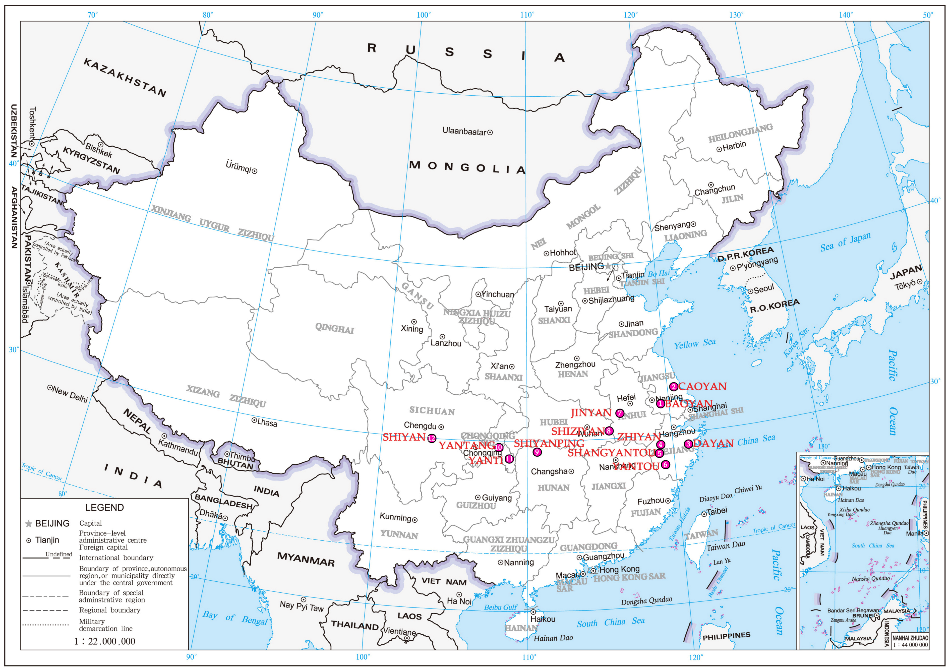
Figure 1. Distribution map of Chinese traditional villages with “yan” in their names.
Buildings 15 04264 g001
Figure 2. Technical roadmap.
Buildings 15 04264 g002
Figure 3. Study area.
Buildings 15 04264 g003
Figure 4. Historical hydrological spatial evolution of Baoyan Village [38].
Buildings 15 04264 g004
Figure 5. Elevation analysis based on DEM (X1).
Buildings 15 04264 g005
Figure 6. NDVI analysis (X2).
Buildings 15 04264 g006
Figure 7. Distribution of major water systems (X3).
Buildings 15 04264 g007
Figure 8. Distribution of basic farmland (X4).
Buildings 15 04264 g008
Figure 9. Analysis of flood inundation depth (X5).
Buildings 15 04264 g009
Figure 10. Historical layout integrity (X6).
Buildings 15 04264 g010
Figure 11. Historical style harmony (X7).
Buildings 15 04264 g011
Figure 12. Distribution map of historical buildings (X8).
Buildings 15 04264 g012
Figure 13. Distribution of population activity density at 7 a.m. (X9).
Buildings 15 04264 g013
Figure 14. Community disaster resistance organization capacity (X10).
Buildings 15 04264 g014
Figure 15. Analysis of land use (X11).
Buildings 15 04264 g015
Figure 16. Transmission of traditional disaster-bearing knowledge (X12).
Buildings 15 04264 g016
Figure 17. Evaluation chart of hydrological resilience indicators.
Buildings 15 04264 g017
Figure 18. Analysis of inundation risk zoning in Baoyan Village.
Buildings 15 04264 g018
Figure 19. Overlay of historic buildings, alleys, and flood-inundated areas.
Buildings 15 04264 g019
Figure 20. The current state of historical alleys in Baoyan Natural Village.
Buildings 15 04264 g020
Figure 21. Monitoring and early warning of population activities in Baoyan Village based on mobile phone signaling (0:00, 17:00, 21:00).
Buildings 15 04264 g021
Table 1. Evaluation index system and weights of historical hydrological resilience.
AimPrimary IndicatorCodeSecondary IndicatorWeight
Calculation of
Historical Hydrological Resilience index
(HHRI)
Ecological Governance ResilienceX1Historical Terrain Change0.05
X2Ecological Vegetation Coverage0.05
X3Natural River Channel Stability0.10
X4Weir Field Integrity0.10
X5Effectiveness of Water Conservancy Facilities0.10
Cultural
Heritage
Resilience
X6Historical Pattern Integrity 0.07
X7Coordination Degree of Historical Features0.07
X8Protection Rate of Traditional Buildings0.06
Social
Adaptation Resilience
X9Disturbance of Crowd Activities0.10
X10Community Disaster Resistance Organization Ability0.05
X11Historical Industry Adaptability0.05
X12Transmission Degree of Traditional Disaster Bearing Knowledge 0.10
Table 2. List of data sources for historical hydrological resilience evaluation.
Primary IndicatorCodeSecondary IndicatorData Source
Ecological Governance Resilience
(0.42)
X1Historical Terrain ChangeHistorical records, DEM
X2Ecological Vegetation CoverageNDVI
X3Natural River Channel StabilityHistorical water system map, remote sensing data
X4Weir Field IntegrityField research, land use data
X5Effectiveness of Water Conservancy FacilitiesEngineering archives, on-site inspection
Cultural
Heritage
Resilience
(0.23)
X6Historical Pattern Integrity Field research, land use data
X7Coordination Degree of Historical FeaturesField research, land use data
X8Protection Rate of Traditional BuildingsField research, land use data
Social
Adaptation Resilience
(0.35)
X9Disturbance of Crowd ActivitiesMobile phone signaling data
X10Community Disaster Resistance Organization AbilityInterview records,
questionnaire surveys
X11Historical Industry AdaptabilityEconomic statistics,
industry research
X12Transmission Degree of Traditional Disaster Bearing Knowledge Intangible cultural heritage survey, oral history
Table 3. Summary table of HHRI (normalization) under different scenarios.
First-
Level Indicator
Ecological
Governance
Resilience
Cultural
Heritage
Resilience
Social
Adaptation
Resilience
CodeX1X2X3X4X5X6X7X8X9X10X11X12
Historical Scenarios1.001.001.001.001.001.001.001.001.001.001.001.00
1.001.001.00
Current Situation0.91 0.42 0.40 0.02 0.54 0.64 0.35 0.39 1.67 1.98 0.26 0.28
0.480.461.05
Table 4. The calculation of obstacle indicators for historical hydrological resilience.
CodeX1X2X3X4X5X6X7X8X9X10X11X12
Obstacle Indicators0.010.090.180.290.140.080.130.11−0.20−0.140.110.21
Table 5. Sources of vital cultural heritage in Baoyan Village.
Levels of Cultural
Value
Heritage
Typology
ResourcesAmount
First LevelImmovable
Cultural Relics
Site of the Four County Anti-Enemy Conference, Taiping Bridge, the Shi Family Residence3
Second LevelHistorical
Buildings
Yi He Wine Celler, Old Magistrate’s Court, Renhe Soya Sauce Workshop, Iron pot shop, the Huang Family Cloth Shop, Wang Shun Xing Restaurant, Wang Rui Ji Cloth Shop, Ming Ji Wine Celler, Yi He Paper Shop, The Yang Family Residence, The Residence in the Middle Camp, Ming Yue Xuan Teahouse, Residence around Taiping Bridge, Bank of the Old Times, Post office in the Republic of China, Zhang Jia Salt Station. 16
Third LevelTraditional BuildingsGreat Temple, Old Barber shop, Site of Wang Gong Sheng Ancestral Hall, Site of Bian Family Ancestral Hall12
Traditional Facilities (Sites)Huang Guan River Floodgate, Little River Floodgate Site, Xiao Ping Bridge Site, Grand Dock Site, Salt Dock Site, Wine Dock Site, Wood Dock Site, Chimney
Table 6. Problem–strategy correlation matrix for enhancing hydrological resilience in traditional villages.
Key Obstacle FactorsNature-Based Solutions (Nbs)Hard Engineering TechniquesSoft Institutions and Community EngagementCultural Activation and Intellectual Inheritance
X3: Stability of natural waterwaysRestore the riverbank buffer zone and plant aquatic plants (reeds, calamus) to stabilize the slope and purify waterEcological slope protection, embedded sensor monitoringEstablish village regulations for river management and protectionIntegrate traditional river management wisdom, such as “planting willows to build embankments”, into modern ecological engineering
X4:
Weir field integrity
Build a terraced landscape belt to exert its ecological function of rain and flood detentionImplement the “Weir Field Adoption” program to create a social innovation of distributed maintenanceUse the weir field system as an experience site for ecological agriculture and nature education to revitalize traditional agricultural wisdom
X12: Inheritance of traditional disaster tolerance knowledgeEstablish a “water lane manager” system and conduct participatory planning workshopsUse AR technology to create immersive educational experiences in water heritage and promote the intergenerational transmission of knowledge
Disclaimer/Publisher’s Note: The statements, opinions and data contained in all publications are solely those of the individual author(s) and contributor(s) and not of MDPI and/or the editor(s). MDPI and/or the editor(s) disclaim responsibility for any injury to people or property resulting from any ideas, methods, instructions or products referred to in the content.