1. Introduction
Rural areas represent complex territorial systems integrating natural, social, and economic dimensions, fulfilling multiple functions including production, habitation, ecology, and culture. They maintain a relationship of mutual reinforcement and coexistence with urban areas, collectively constituting the primary living spaces for human activities [
1]. China’s fundamental national conditions dictate that rural development remains a crucial aspect of its national modernization process. Since the initiation of reform and opening-up policies in 1978, rapid industrialization and urbanization have driven profound transformations in the economic and social structure. The urbanization rate has risen significantly from 17.92% in the early stage to 67.00% in 2024 [
2]. According to projections by relevant United Nations agencies, China’s urbanization level is expected to stabilize at around 70% for a considerable period in the future, differing from the high urbanization model of 80–90% seen in Western developed nations [
3]. Within this context, rural areas will continue to serve the dual functions of a socio-economic “stabilizer” and a “reservoir” for urban–rural population flows [
4], making their sustainable development strategically significant for the nation.
However, the rapid advancement of urbanization has also exacerbated rural population outflow, leading to a gradual erosion of traditional rural social structures. This has resulted in typical rural contraction phenomena such as abandoned farmland, village hollowing, and housing vacancy [
5]. Statistical data indicate that between 2000 and 2024, China’s rural population decreased from 808 million to 465 million, with an average annual reduction of approximately 14 million people [
6]. Despite this demographic decline, the scale of rural housing construction has paradoxically expanded, with per capita housing area increasing rather than decreasing. The total building stock in both urban and rural China currently exceeds 600 million units, with rural buildings accounting for 90% of the total number of units and 50% of the total floor area [
7], creating a resource allocation paradox characterized by population decline paradoxically coexisting with housing expansion. This phenomenon stems partly from lower construction costs in rural areas and is further reinforced by deep-seated cultural notions such as “deep-rooted attachment to native land” and “glorious homecoming”, which drive many migrant workers to build houses in their places of origin [
8]. Consequently, the issues of high housing vacancy rates and inefficient spatial utilization have emerged as one of the core challenges constraining rural revitalization and the improvement of human settlements [
9,
10].
This issue is particularly pronounced in the Hexi Corridor region, characterized by its fragile ecosystem and lagging economic development. The rural population in this region has declined by 38% compared to 2013 [
11], while the per capita residential floor area has conversely increased by 36% [
12], indicating a notable phenomenon of housing vacancy. Concurrently, the area is constrained by extreme climatic conditions: severely cold and dry winters, significant diurnal temperature variations in summer, and intense solar radiation year-round, creating a typical “conflict between solar gain and overheating”. In response to seasonal climate variations and the challenge of underutilized housing, a spontaneous “Seasonal Room Rotation” living pattern has emerged locally, wherein residents selectively occupy different rooms based on distinct environmental needs during winter and summer. Although this pattern reflects vernacular wisdom in the adaptive use of spatial resources, the lack of systematic research and methodological guidance means its potential for improving the building thermal environment remains underdeveloped.
Current academic research on rural contraction predominantly focuses on the village planning level, while a systematic exploration integrating spatial resource allocation with green performance enhancement at the individual building scale is notably lacking. Particularly for the spontaneously formed “Seasonal Room Rotation” living pattern in the Hexi Corridor region, there is an absence of scientific analysis from a climate adaptability perspective and parametric design verification, which constrains the targeted improvement of green performance in local rural residences. To address this gap, this study targets rural dwellings in the Hexi Corridor and integrates field investigations, climate analysis, on-site measurements, performance simulation, and multi-objective optimization methods to achieve the following research objectives:
- (1)
To systematically identify the formation mechanisms and spatial characteristics of the “Seasonal Room Rotation” living pattern;
- (2)
To propose a green performance enhancement methodology integrating passive design strategies with spatial functional differentiation;
- (3)
To establish a quantified design parameter system applicable to this pattern, providing a scientific basis and technical support for rural residential renewal.
This study not only theoretically expands the research dimension of seasonal spatial adaptation mechanisms by elevating the issue of climate adaptation from an internal trade-off within single rooms to spatial resource allocation at the holistic building level, but also methodologically explores a technical pathway combining multi-objective optimization with regional green wisdom. The research outcomes hold significant application value for promoting the green construction of rural dwellings in the severe cold regions of Northwest China.
2. Literature Review
2.1. Research on Rural Development in the Context of Population Contraction
In the late 20th century, alongside the deepening development of industrial society, cities in numerous countries and regions across Europe and America began to experience population decline and economic recession. Within this context, American scholars Popper, D.E. and Popper, F.J. postulated the concept of “Smart Shrinkage” in 2002, emphasizing the need to “plan for fewer people, less dwelling, and less land” [
13]. This theory advocates for a shift in developmental focus from expansion to the optimization of existing resources in contexts of population loss or declining spatial demand. It proposes proactively and rationally addressing future challenges through the reintegration, adjustment, or reduction in limited resources to foster comprehensive regional progress. Subsequent scholarship has engaged in extensive discussion and expansion of this theory, with research covering multiple dimensions including the key factors influencing smart shrinkage, specific implementation strategies, and practical applications in planning [
14,
15].
As early as the 1950s and 1960s, rural Japan began experiencing population outflow and aging, accompanied by issues of social structure disintegration and housing vacancy [
16]. Matanle, P. and Feldhoff, T. systematically analyzed the phenomena and impact mechanisms of rural shrinkage in Japan, conducting an in-depth examination of coping and development strategies for “shrinking communities” [
17,
18]. In Nordic regions, researchers generally attribute rural contraction to factors such as population migration, accelerated aging, and insufficient educational resources [
19]. Anne, T. and Gertrud, J. proposed a strategic planning framework applicable to rural areas [
20]. Furthermore, Naldi, L. and Nilsson, P. deeply analyzed the logical framework underlying rural shrinkage policies and their connections to future empirical research [
21]. Additionally, Pužulis, A. and Kūle, L. systematically analyzed regional variations in the state of rural shrinkage in Northeastern Latvia [
22].
With the ongoing advancement of urbanization in China, the theory of smart shrinkage has been progressively introduced into the field of rural development research. Scholars have explored rural smart shrinkage from multiple dimensions, including its driving mechanisms [
23], coping strategies [
24], and implementation pathways [
25,
26]. The research subjects encompass areas with diverse geographical characteristics [
27,
28,
29], various village types [
30,
31,
32], and different spatial scales [
33,
34,
35]. At the macro level, Jing, X.P. proposed a systematic technical pathway to transition rural areas from passive decline to active contraction [
36]; Zhao, M. introduced quantitative analysis methods into this field, constructing a rural shrinkage model and conducting empirical testing [
37]; Ma, Y.B. put forward rural planning strategies guided by smart shrinkage [
38]; Cheng, Z.Q., from the perspective of theoretical applicability, analyzed the inherent logical alignment between the concept of smart shrinkage and rural planning in China [
39]. At the meso level, Guo, Y. taking Wuhan City as an example, systematically discussed the compilation methods and content framework for rural settlement system planning, clarifying settlement scale and spatial layout schemes [
40]; Wang, Y.C. focused on the Southern Jiangsu region, analyzing the practical challenges within the rural contraction process and proposing adaptive planning countermeasures [
41]. At the micro level, Zou, Y.F. addressed development issues in mountainous villages, establishing a spatial planning and development system for mountainous rural areas based on “smart shrinkage” [
42]; Du, Z.W. focused on suburban areas, providing an in-depth analysis of the spatial characteristics, formation mechanisms, and transformation development models of rural contraction [
43].
2.2. Research on Strategies for Enhancing the Green Performance of Rural Buildings
Green building, targeting sustainable development, aims to create healthy, comfortable, and pleasant built environments while minimizing the consumption of natural resources and negative environmental impacts through design optimization and technology integration. In developed countries, green building has established a mature industrial foundation in new materials, construction techniques, and component systems, and is progressively shifting towards in-depth research and development of zero-energy and ultra-low energy buildings. Represented by nations such as the United States, Germany, and Japan, and leveraging their economic and technological advantages, high-tech applications like solar thermal systems and high-performance energy-efficient materials are directly implemented in rural housing construction. These practices can be regarded as outcomes of a high degree of integration between technological advancement and economic capacity. In contrast, China still faces certain gaps in its green building technology system, industrialized construction level, and whole-process collaboration. Particularly, the disconnect between technical means and regional economic and cultural contexts significantly hinders the promotion and application of green building technologies in rural areas.
China’s vast territory encompasses significant regional disparities in natural conditions, economic development, and cultural characteristics. Consequently, the core issues and developmental goals of green building practices vary considerably across specific regions [
44]. Within this context, academic teams, primarily from universities, have selected typical geographical areas as research subjects. By integrating multidisciplinary approaches, they have conducted systematic investigations and accumulated a substantial body of research. For instance, Academician Liu, J.P. conducted scientific analysis and systematization of the ecological wisdom inherent in traditional dwellings in Western China [
45]. Song, Y.H. developed a localized green building design framework and technical pathways [
46,
47,
48]. Meanwhile, Lin, B.R. proposed climate-responsive green building strategies tailored to different climatic zones, establishing a design process that synergistically advances spatial configuration, functional organization, and technologies for enhancing environmental performance [
49,
50,
51].
The Hexi Corridor, located in the inland northwest of China, experiences an extremely cold and arid climate, making the optimization of green performance in its rural residences a significant topic in regional architectural research. Li, Y. systematically summarized construction modes for rural human settlements adapted to the characteristics of ecologically fragile areas [
52]. Zhao, B. conducted an in-depth exploration of the climate-responsive features inherent in the architectural forms of local traditional dwellings, deriving corresponding technical strategies and design principles [
53]. Zhang, Z.W. and colleagues dedicated their efforts to exploring contextually “appropriate” renovation and renewal pathways for the vernacular dwellings in this region [
54]. Chen, J. and others analyzed the passive design methods of traditional residences in the severe cold and cold zones of Gansu Province, extracting a pattern language for passive design with local characteristics [
55]. He, J.Z. further proposed a system of passive design strategies applicable to rural dwellings in the Hexi Corridor [
56,
57]. Shu, Z.W. focusing on rammed earth dwellings in Minqin County, performed ecological performance simulations from the three dimensions of light, wind, and thermal environments, summarizing their ecological wisdom and screening suitable eco-building technologies [
58]. Sun, Y. based on the prototype of fortress dwellings, systematically analyzed their ecological performance in terms of light, wind, and thermal environments [
59]. Qi, H.Y. adopted a broader perspective of human settlements, analyzing the impact mechanisms of negative environmental factors in desertified areas, identifying their endogenous development drivers, and subsequently exploring sustainable development trajectories and new architectural paradigms for human settlements in this region [
60].
In summary, current domestic research on rural contraction predominantly focuses on phenomenon identification and strategy formulation at the macro and meso levels, while in-depth exploration at the micro level, particularly at the scale of individual buildings, remains insufficient. Although existing studies have made achievements in proposing general response pathways, they seldom address nuanced responses regarding the functional reorganization, performance optimization, and usage efficiency of specific living spaces. To bridge this research gap, this study shifts the focus down to the individual residential unit level. It systematically examines the actual usage patterns and contradictions of rural dwellings, and subsequently proposes optimized design parameters—including courtyard morphology, building height, window-to-wall ratio, and shading component dimensions—tailored to the emerging “Seasonal Room Rotation” living pattern. This research not only significantly enhances spatial utilization efficiency and seasonal adaptability of residences but also addresses a critical gap in rural contraction studies at the architectural micro-level, providing actionable design pathways for improving the quality and efficiency of rural human settlements within the context of existing building stock.
3. Materials and Methods
3.1. Materials
3.1.1. Research Object
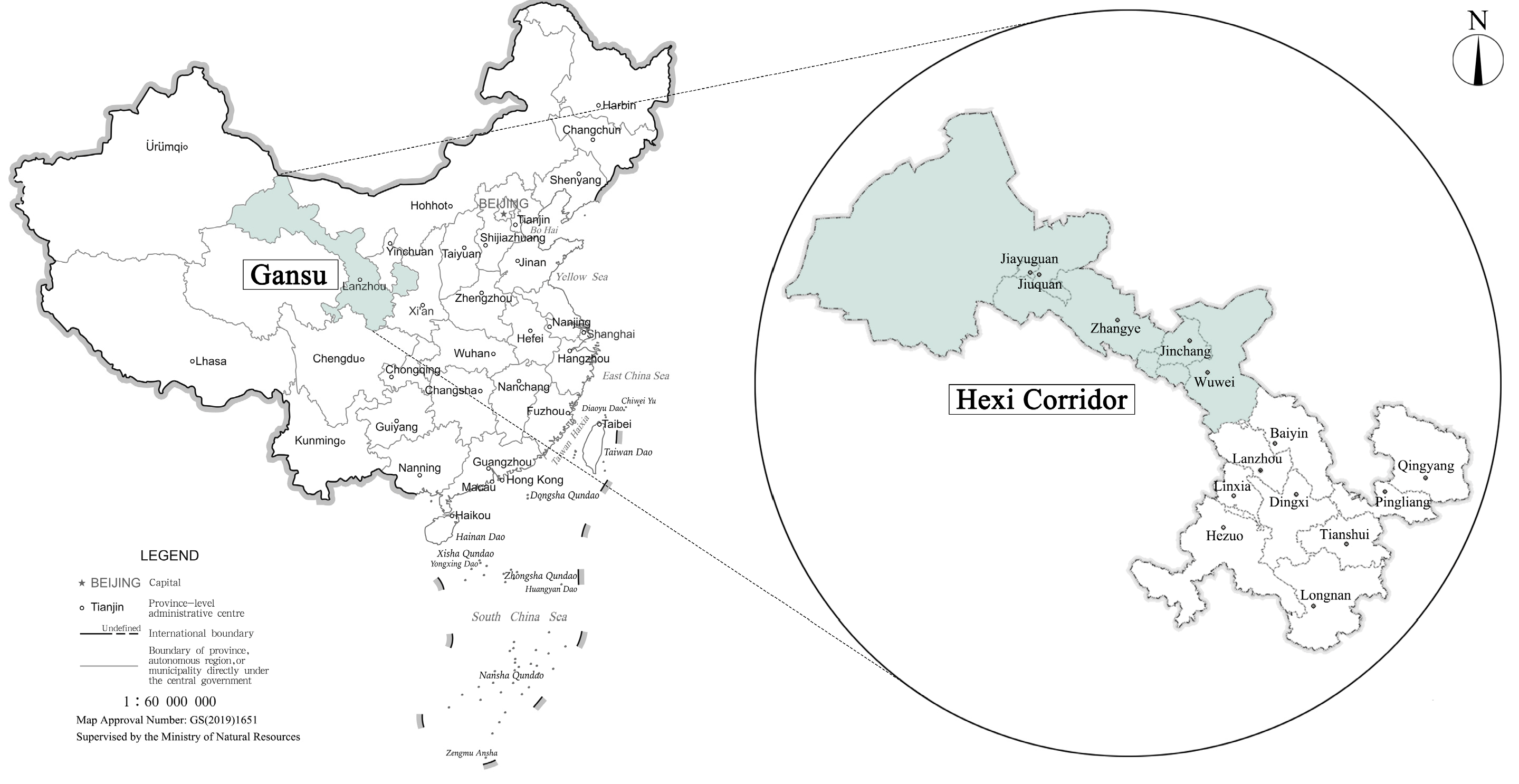
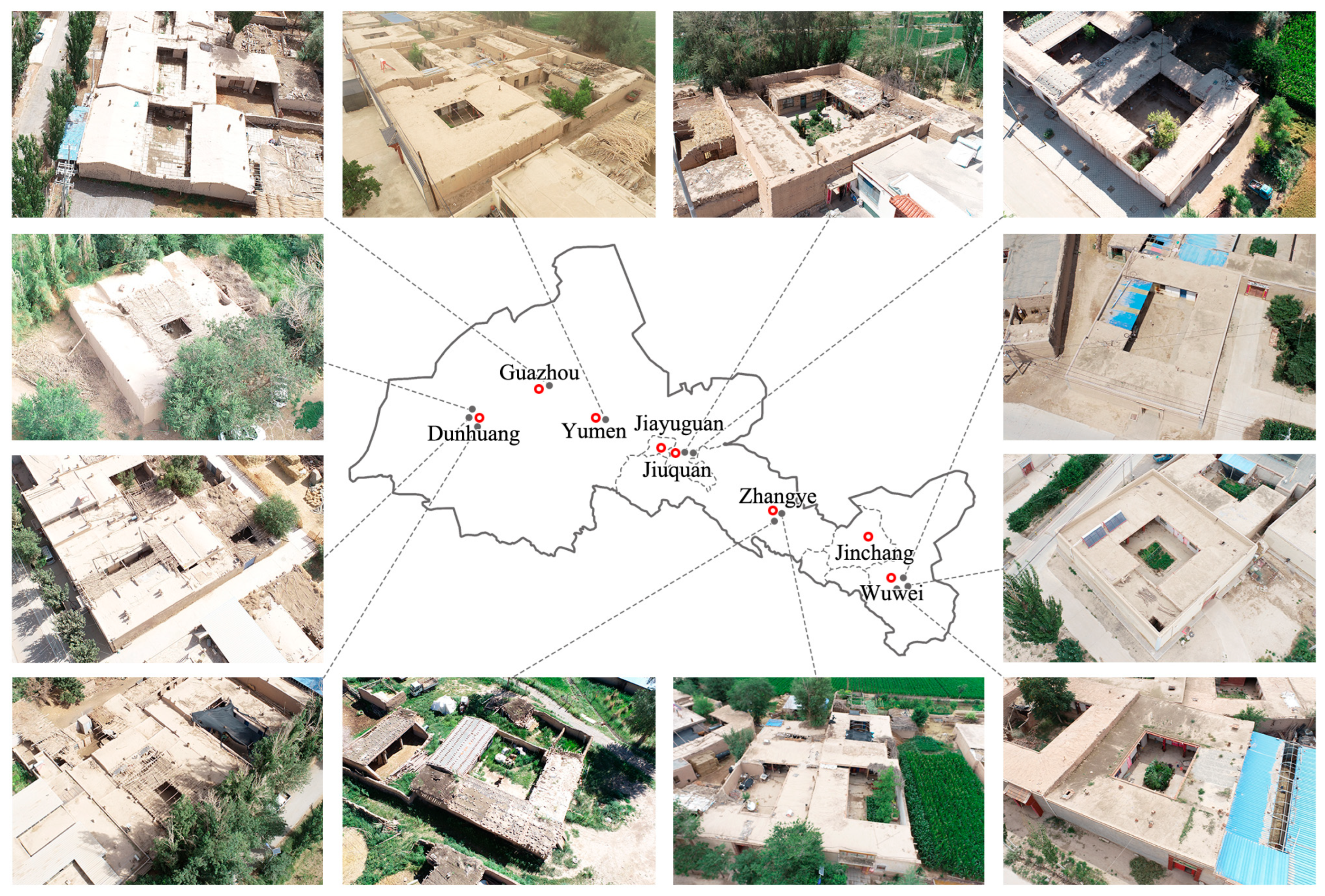
The Hexi Corridor is situated in the northwestern part of Gansu Province, characterized by a long and narrow shape stretching longitudinally from east to west. It extends from the Wushao Ling in the east to the border between Gansu and Xinjiang in the west, bounded by the Qilian Mountains to the south and the Beishan Plateau to the north. The region spans approximately 1200 km in length with a width ranging between 100 and 200 km. It derives its name, “Hexi Corridor” (meaning ‘Corridor West of the River’), from its geographical position west of the Yellow River and its distinctive corridor-like topography. The area encompasses several cities, including Wuwei, Jinchang, Zhangye, Jiuquan, and Jiayuguan (
Figure 1).
3.1.2. The “Seasonal Room Rotation” Living Pattern
Rural residences in the Hexi Corridor region predominantly feature a courtyard-style layout, typically oriented southwards. The main house (Zhengfang) on the north side is the most formally significant and spatially expansive structure within the compound, usually occupied by elders. Its flanking rooms (Erfang) often serve as kitchens and storage spaces. The east and west wing rooms (Xiangfang) function as living quarters for children, while the southern reverse-set rooms (Daozuofang) combine residential and storage functions. In the past century, multi-generational co-residence was common, with compounds typically containing multiple wing rooms to accommodate large families. However, sustained rural population decline has led to significant demographic shifts. Often, only elderly couples remain as permanent residents, while their children are typically away for education, work, or have settled elsewhere, returning only temporarily during specific periods like the Spring Festival. This has resulted in numerous rooms remaining vacant for extended periods.
Against this backdrop, residential usage patterns have evolved. Residents spontaneously developed a new “Seasonal Room Rotation” living pattern, flexibly selecting suitable rooms based on seasonal variations in location, openness, and thermal performance. For instance, during summer, residents often prefer the main house for its spaciousness and better ventilation, which aids cooling. In winter, they might relocate to smaller, more easily heated rooms like the wing rooms to minimize heat loss. This spontaneous practice of designating separate “Winter Rooms” and “Summer Rooms” for seasonal use reflects the residents’ active adaptation to the local climate and effectively enhances the practical utilization efficiency of the available space (
Figure 2).
3.1.3. The “Conflict Between Solar Gain and Overheating” Phenomenon
Most of the Hexi Corridor is classified as a severe cold zone [
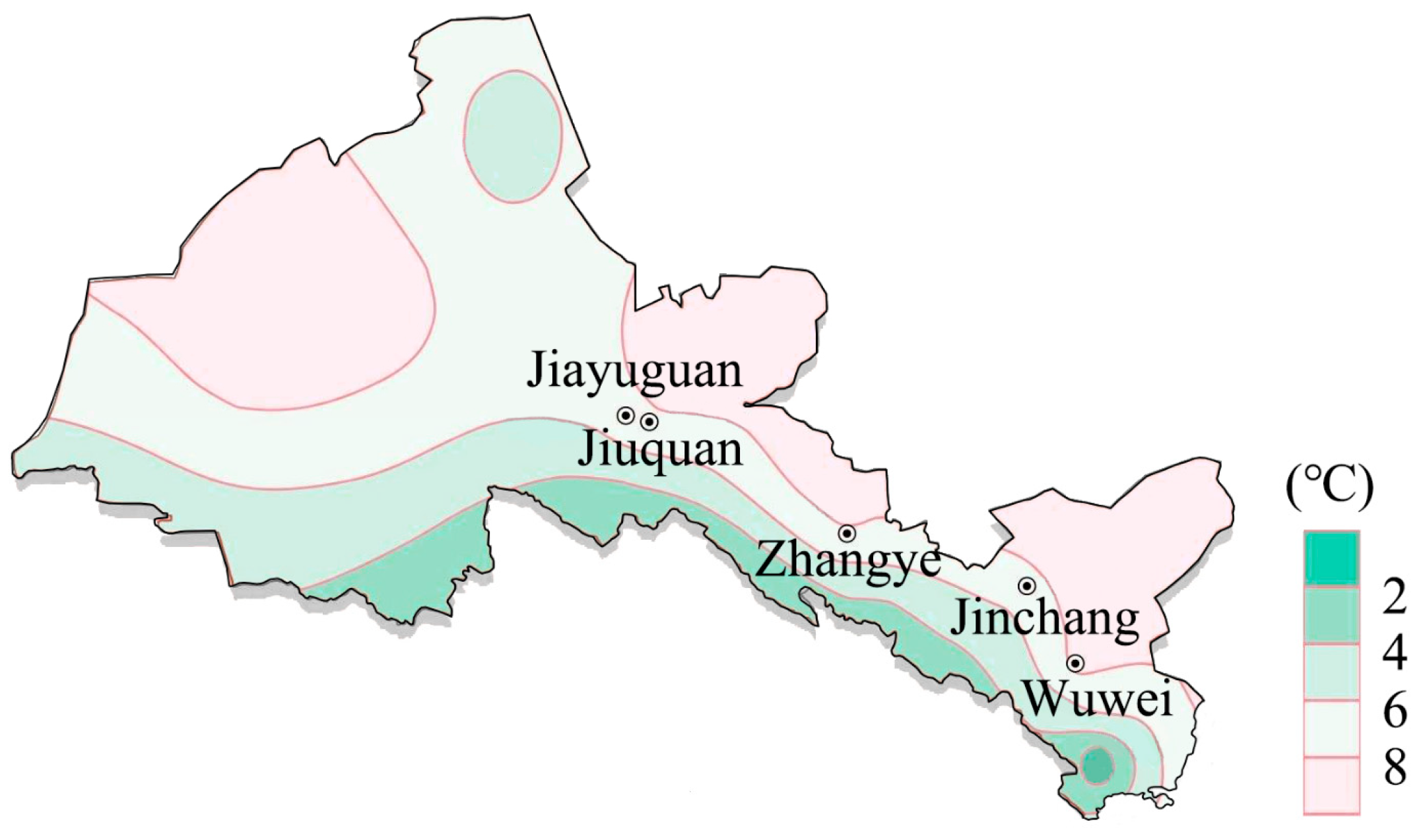
61], characterized by extremely cold winters and significant diurnal temperature variations in summer. The region’s mean annual temperature ranges from 7.8 °C to 9.9 °C (
Figure 3). The average daily temperature of the hottest month ranges from 25.88 °C to 32.35 °C, while that of the coldest month drops to as low as −15.53 °C to −12.56 °C. Concurrently, the area experiences intense solar irradiation and high atmospheric transparency, resulting in weak solar radiation attenuation and consequently high levels of solar radiation received at the ground surface. The annual sunshine duration reaches 2600 to 3400 h (
Figure 4), and the average annual total solar radiation on a horizontal surface is exceptionally high, ranging from 5762 to 6398 MJ/m
2 [
62], substantially exceeding the national average of 1519 MJ/m
2. These climatic conditions create a pronounced “conflict between solar gain and overheating”: buildings require maximal solar heat gain for passive heating in winter, yet necessitate effective shading to mitigate excessive solar heat gain in summer.
- 2.
Thermal Comfort Survey
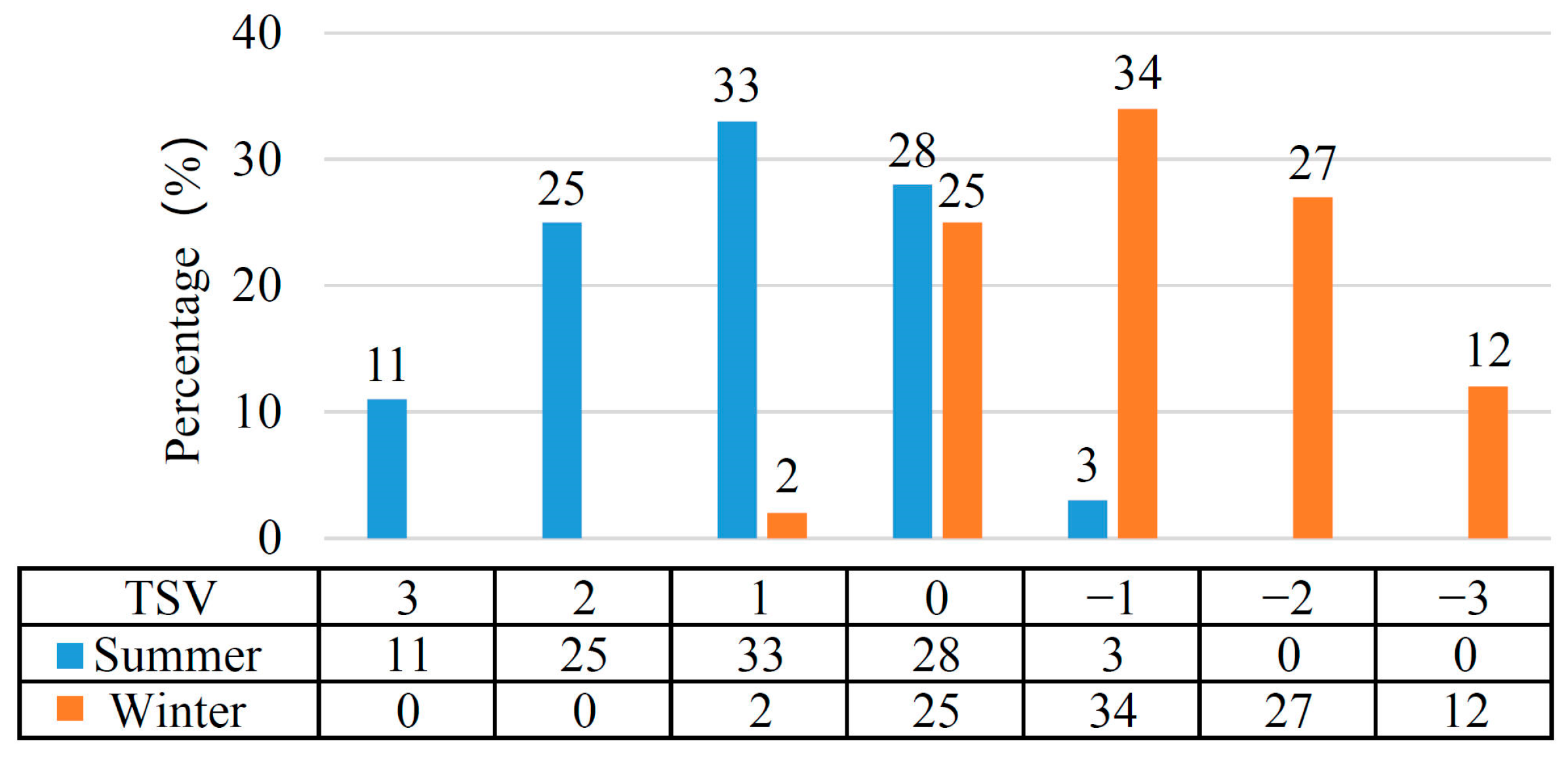
A Thermal Sensation Vote (TSV) was used for evaluation, with the scale defined as: “−3 (Cold), −2 (Cool), −1 (Slightly Cool), 0 (Neutral), +1 (Slightly Warm), +2 (Warm), +3 (Hot)”. The results indicated that in summer, 69% of residents felt warm to hot (TSV = +1 to +3), while in winter, 73% felt slightly cool to cold (TSV = −1 to −3) (
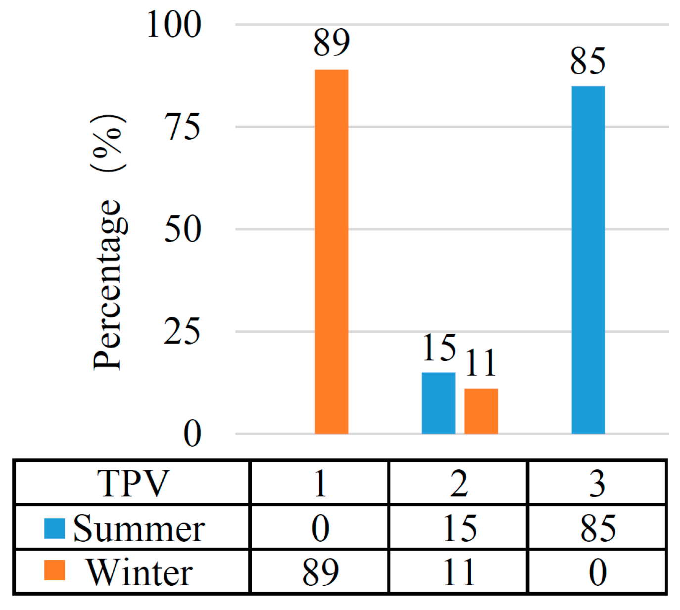
Figure 5). Although clothing adjustment could alleviate discomfort to some extent, from the perspective of thermal preference—using a scale of “1 (Prefer Warmer), 2 (No Change), 3 (Prefer Cooler)”—85% of residents preferred a cooler environment in summer (+3), and 89% preferred a warmer environment in winter (+1) (
Figure 6). These data sufficiently demonstrate that existing residences still commonly suffer from poor indoor physical environments and low thermal comfort levels.
3.1.4. Building Performance Enhancement Strategies
- 1.
Architectural Characteristics
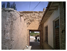
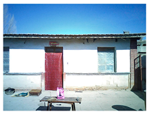
Rural residences in the Hexi Corridor region predominantly exhibit a regular rectangular layout, typically organized into distinct front and rear courtyards. The front yard serves as the primary living area, while the rear yard accommodates auxiliary functions such as storage, livestock rearing, and dry toilets. The courtyard configuration is characterized by external enclosure and internal openness, bounded by rammed earth walls on all sides. With the exception of the main entrance, no other external windows are present. All interior room doors and windows open directly onto the internal courtyard, a design that ensures resident privacy while simultaneously facilitating natural daylighting and ventilation. Roof structures primarily consist of single-slope or curved (roll-beam) roofs, commonly featuring overhanging eaves or verandas, which collectively form a distinctive regional architectural vocabulary (
Figure 7). Field survey data indicate the following typical dimensional ranges: courtyard length-to-width ratios of 0.78 to 1.87, courtyard areas of 45 m
2 to 132 m
2, building heights of 3 m to 4.5 m, room depths of 3.8 m to 5.2 m, and shading component dimensions ranging from 0.6 m to 2.6 m.
- 2.
Passive Building Strategies
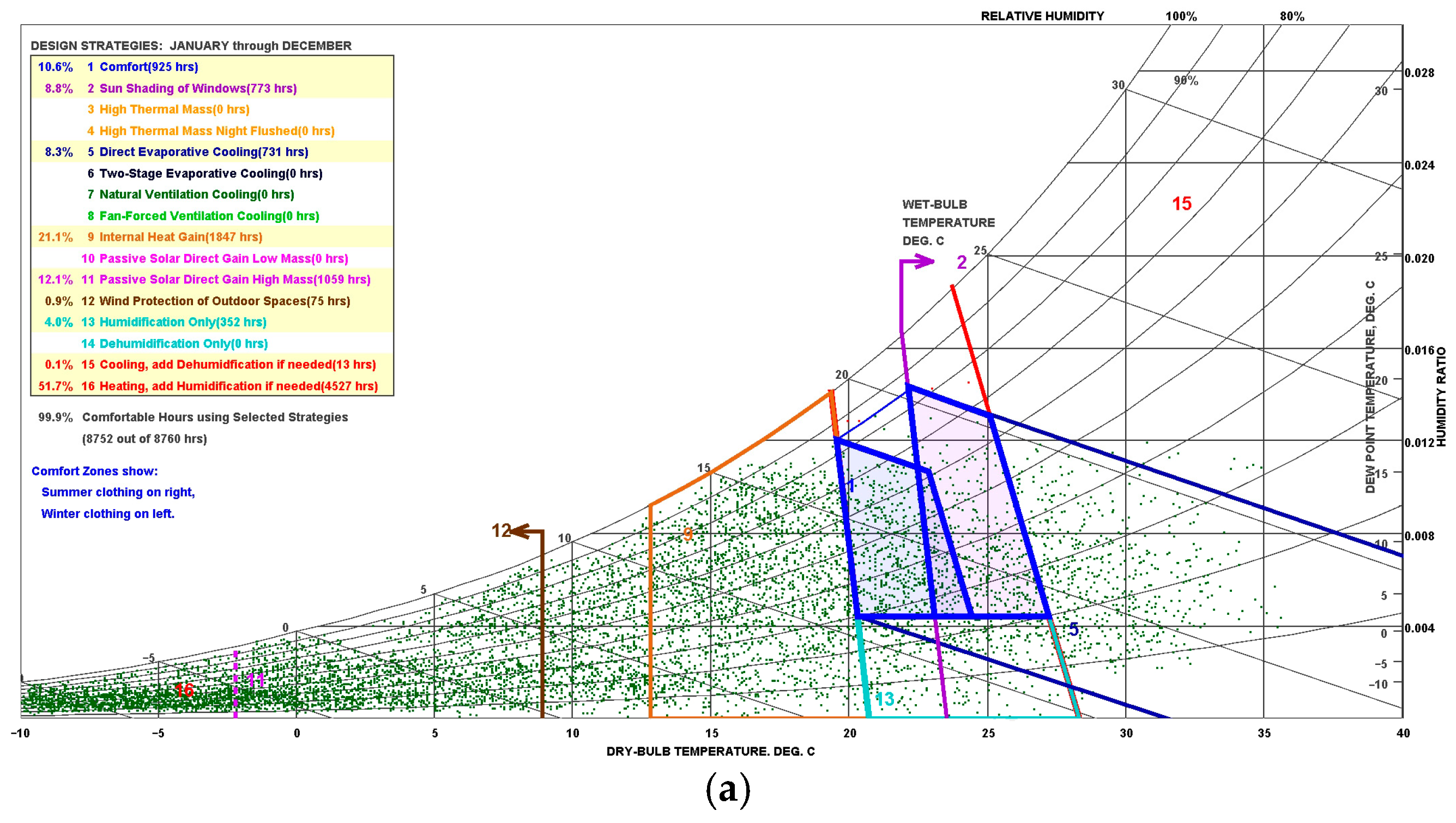
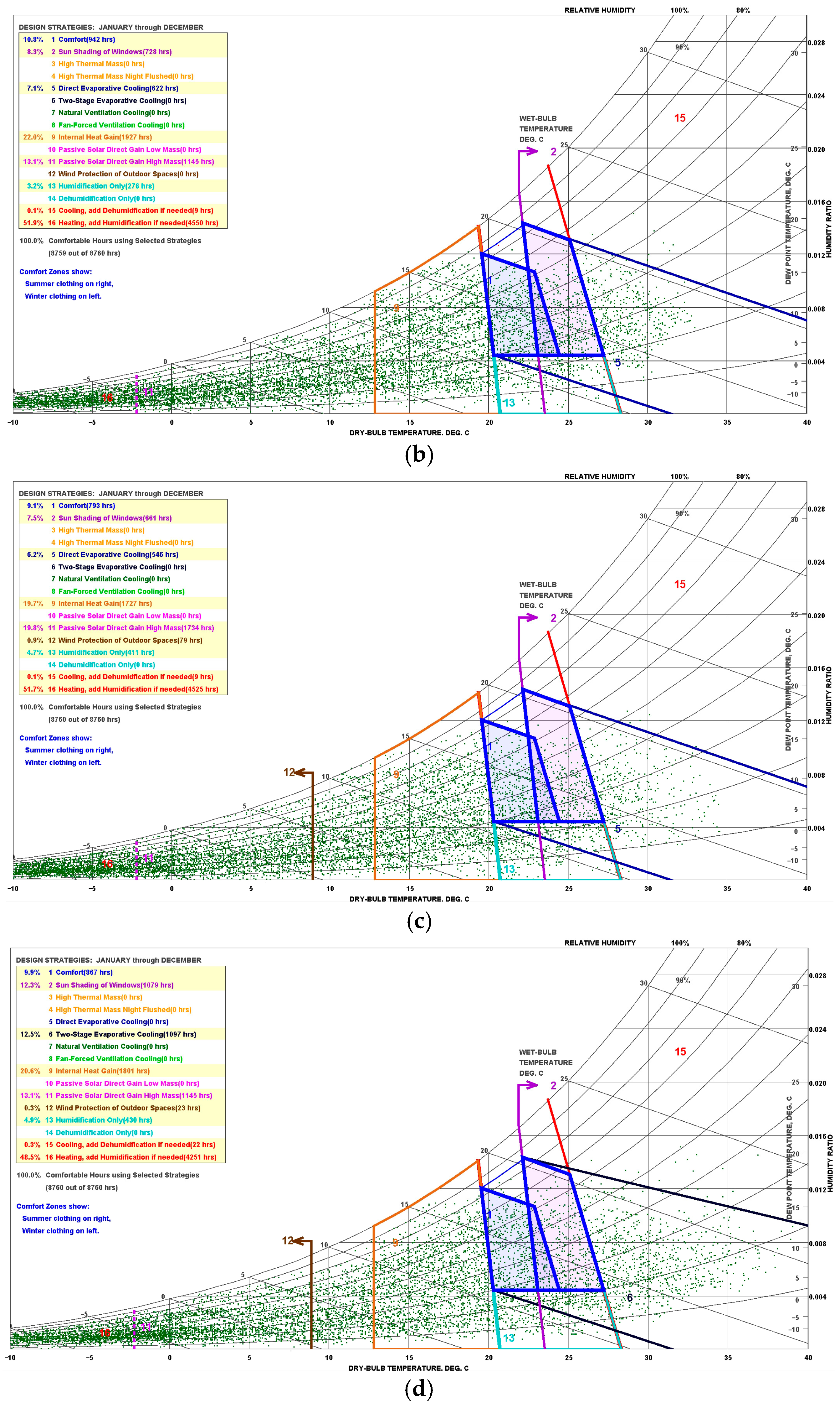
This study utilized meteorological parameters from Wuwei, Jiuquan, Yumen, and Dunhuang based on the Chinese Standard Weather Data (CSWD) [
63]. Climate analysis was performed using the ASHRAE Standard 55-2004 [
64] comfort model integrated within the Climate Consultant software (v6.0) [
65], generating psychrometric charts for each location (
Figure 8). The analysis results indicate that passive solar heating and architectural shading are the most effective passive design strategies for this region [
66,
67].
Through long-term evolution, local traditional dwellings have accumulated a wealth of adaptive construction experience. This is manifested in the regulation of courtyard form ratios, control of building height, optimization of the window-to-wall ratio for different orientations, and the incorporation of shading components such as overhanging eaves. These measures aim to maximize solar heat gain in winter while effectively blocking direct solar radiation in summer, thereby moderating the indoor physical environment (
Figure 9). Building upon these traditional adaptations, this study systematically applies passive building design strategies to further explore their potential for improving indoor thermal comfort and enhancing the green performance of buildings, with the specific aim of strengthening the climate adaptability of the designated “winter rooms” and “summer rooms” in rural residences.
3.1.5. Solar Radiation Temperature Field Measurement
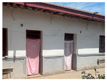
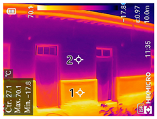
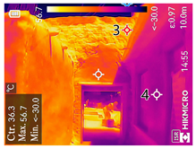
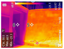
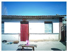
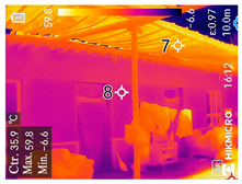
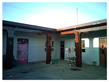
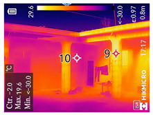
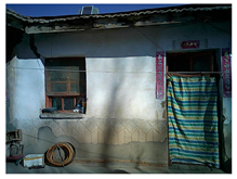
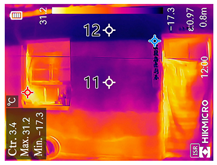
To systematically validate the actual effectiveness of passive solar heating and building shading strategies in the Hexi Corridor region, this study selected eight representative rural residences in typical areas such as Wuwei, Zhangye, and Jiuquan for on-site measurements. The measurements were conducted during two typical seasons: summer (June–July 2024) and winter (January–February 2025). The focus was on monitoring the temperature response of exterior wall surfaces under solar radiation across different seasons. By comparing the temperature differences between sun-exposed and shaded wall areas, the actual effectiveness of shading components and passive solar utilization was quantified. A high-precision infrared thermal imager was employed for the measurements; its specific technical parameters are listed in
Table 1.
- 2.
Summer Solar Radiation Temperature Field Measurement
Field measurement data during summer demonstrated that wall surface temperatures under direct sunlight were significantly higher than those under shaded conditions. The temperature differences varied across measurement points depending on wall material, orientation, and measurement time. Specifically, the temperature at Point 1 was 36.3 °C higher than at Point 2; Point 3 was 29.0 °C higher than Point 4; the difference between Point 5 and Point 6 was 15.1 °C; and Point 7 was 18.3 °C higher than Point 8 (
Table 2). The results indicate that shading components can effectively reduce wall heat gain in summer, playing a significant role in improving the indoor thermal environment.
- 3.
Winter Solar Radiation Temperature Field Measurement
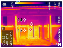
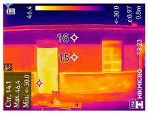
Winter measurement results similarly indicated that wall surfaces exposed to direct solar radiation exhibited significantly higher temperatures than those in shaded areas. Specifically, the temperature difference at Measurement Point 9 exceeded that at Point 10 by 21.6 °C; Points 11 and 12 differed by 7.2 °C; Point 13 was 16.8 °C higher than Point 14; and the temperature difference between Points 15 and 16 was 12.7 °C (
Table 3). These data confirm the feasibility of utilizing solar energy for passive heating during winter, reflecting the region’s significant potential for harnessing solar resources in the cold season.
The field measurement data presented above provide empirical support for the assumptions and conclusions of the subsequent simulation study, enhancing the reliability and practical applicability of the research findings.
3.2. Methods
3.2.1. Tool Selection and Validation
Architectural spatial elements—such as courtyard morphology, building height, window-to-wall ratio, and shading components—do not function independently but collectively influence the overall building performance through synergistic or mutually constraining interactions. It is therefore essential to systematically evaluate the coupling effects between these parameters. Traditional single-factor analysis methods prove inadequate for effectively addressing such multi-parameter optimization problems. Consequently, this study employs a Multi-objective Optimization (MOO) approach to systematically explore optimal indoor environmental solutions under the combined influence of multiple factors.
The core of multi-objective optimization lies in handling multiple conflicting objectives. This process involves establishing mathematical models to identify the most reasonable solutions from all feasible alternatives that satisfy the constraint conditions, thereby simultaneously optimizing multiple objectives to support complex decision-making. Common strategies include non-dominated sorting, diversity preservation, and elitism preservation, with representative algorithms including NSGA-II, SPEA-2, and PAES [
68]. This study employs the fast non-dominated sorting genetic algorithm NSGA-II [
69], which has been demonstrated by Lai, W.X. et al. [
70] to exhibit high operational efficiency and uniform solution distribution, making it particularly suitable for building performance optimization problems. Practical research by Shang, R.H. et al. [
71] further confirms that its computational results in building performance optimization outperform other representative algorithms. The optimization process is implemented using the Wallacei plugin on the Grasshopper (for Rhino 7 for Win) platform.
Since genetic algorithms inherently lack building physics simulation capabilities, this study employs the Ladybug (v0.0.68) + Honeybee (v0.0.65) (L + H) toolset on the Grasshopper platform for environmental performance simulation. This platform integrates rigorously validated simulation engines such as Radiance (v0.0.65) and EnergyPlus (v0.0.65), enabling reliable climate analysis, radiation calculations, and indoor environmental simulations [
72]. Comparative studies by Kirimtat, A. [
73], Alsukkar, M. [
74], and Manmatharasan, P. [
75] have validated the accuracy of L + H simulation results against field measurement data for indoor thermal environment modeling. Experimental work by Motamedi, S. [
76], Khidmat, R.P. [
77], and Kharvari, F. [
78] has further confirmed the toolset’s effectiveness for indoor illuminance simulation.
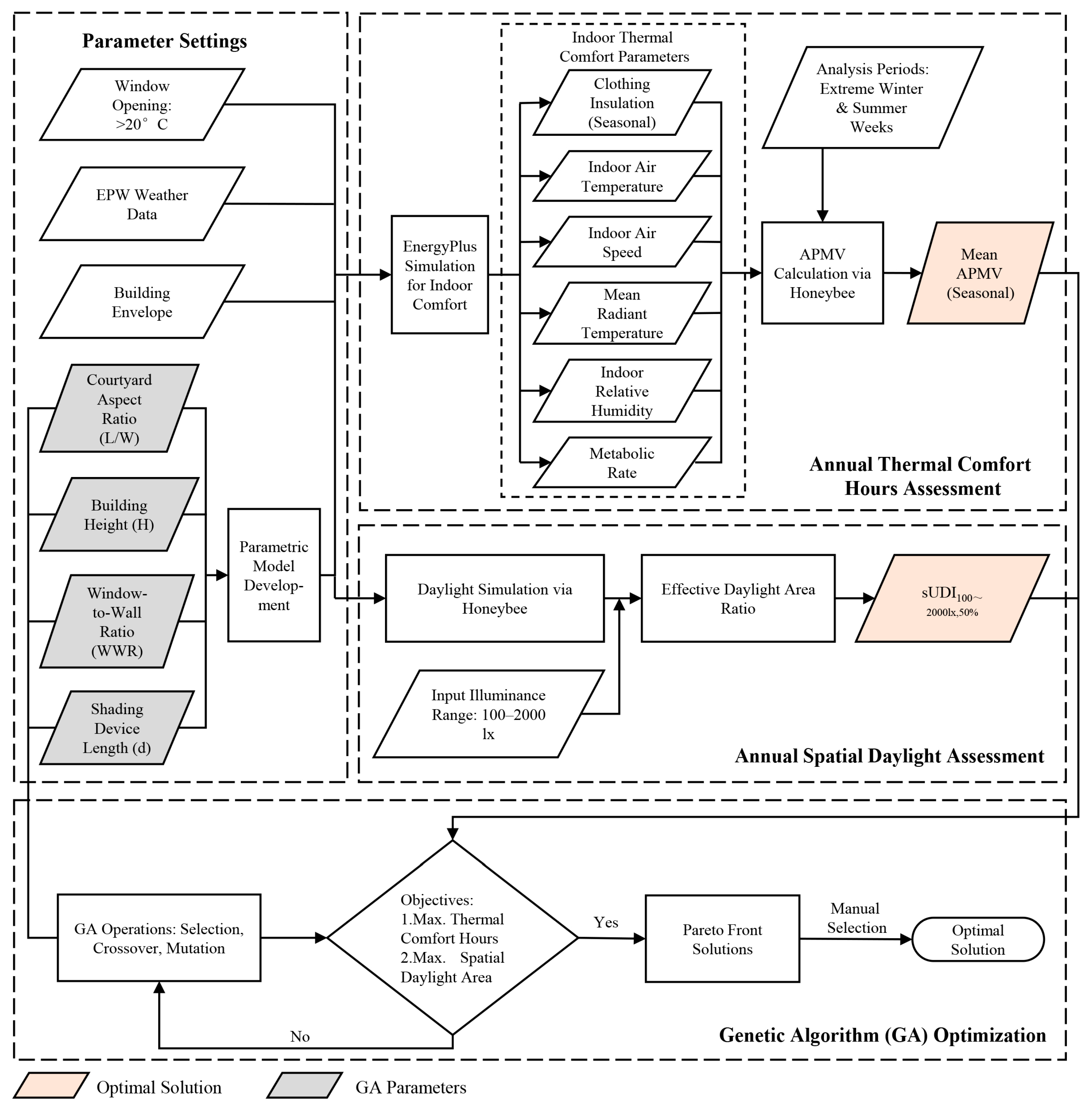
Based on these validation studies, this research utilizes the L + H toolset for physical environment simulation. Specifically, indoor thermal comfort metrics are calculated through the combined EnergyPlus and Honeybee engines, while indoor illuminance is simulated using the Honeybee engine. The overall research workflow is illustrated in
Figure 10.
3.2.2. Research Model Establishment
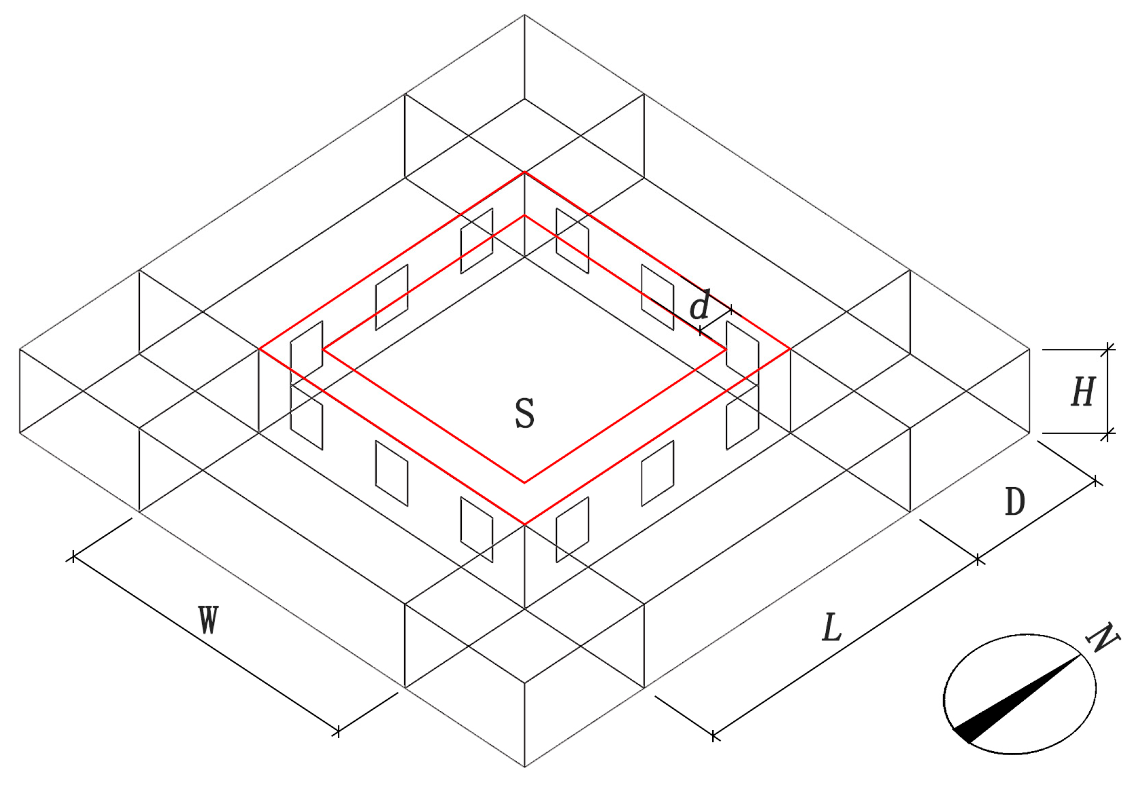
Key parameters influencing the indoor building environment include building morphology and the thermal performance of the building envelope. This study focuses on the regulation of parameters at the building morphology level, specifically investigating the synergistic effects of spatial variables—including the courtyard morphology ratio, building height, window-to-wall ratio, and shading component dimensions —on building performance. To control variables, the simulation model was simplified as follows: the courtyard area (S) was set to a fixed value of 100 m
2, the courtyard length-to-width ratio (L/W) varied from 2:1 to 1:2, the building height (H) ranged between 3.0 m and 4.5 m, the building depth (D) was uniformly set at 4.5 m, the room window-to-wall ratio (WWR) was set in the range of 0 to 0.4, the shading component dimension (d) was set from 0 to 2.4 m, and the building orientation was set to a true north–south layout (
Figure 11). To mitigate interference from structural variations on the simulation results, the constructions of the roof, walls, and ground were standardized to common practices of local traditional rammed earth buildings. The thermal parameters of the materials—including material composition, thickness, thermal conductivity, and specific heat capacity—were set as fixed values, as detailed in
Table 4.
3.2.3. Calculation of Annual Indoor Adaptive Thermal Comfort Evaluation Index
This study selects the Adaptive Predicted Mean Vote (APMV) as the evaluation criterion for the indoor thermal environment. Unlike the Predicted Mean Vote (PMV), the APMV incorporates negative feedback mechanisms of psychological and behavioral adjustments on human thermal perception, making it more suitable for assessing naturally ventilated buildings [
79]. Its calculation formula is as follows:
In the formula, λ is the adaptive coefficient, dependent on the climatic conditions and building type of the study area. Given that most of the Hexi Corridor region falls within the severe cold zone and the research object is rural residences, λ was set to 0.24 when PMV ≥ 0, and λ = −0.5 when PMV < 0 ([
80], p. 9).
Other relevant parameters were set as follows: windows were considered open when the outdoor temperature exceeded 20 °C, and the indoor air speed was determined accordingly. Considering typical resident clothing in winter and summer, referencing the technical requirements for a thermal manikin from standards and combining it with local residents’ dressing habits: summer clothing typically included underwear, a undershirt, long-sleeved upper garment, trousers, socks, and shoes, with an average clothing insulation of 0.55 clo; winter clothing included underwear, long-sleeved and legged underwear, trousers, a sweater, an outer garment, socks, and shoes, with an average clothing insulation of 1.54 clo.
The study utilized the EnergyPlus Weather File (EPW) for the Jiuquan area from the Chinese Standard Weather Data (CSWD). The extreme cold week in winter (13–19 January) and the extreme hot week in summer (6–12 July) were selected as experimental periods.To accurately characterize the indoor thermal environment and prevent data bias caused by temperature stratification, this study, with reference to the stipulations of the “Evaluation Standard for Indoor Thermal and Humid Environment of Civil Buildings” (GB/T 50785-2012) ([
80], p. 14), selected three horizontal planes at heights of 0.1 m, 0.6 m, and 1.1 m above the finished floor level as representative sections. The 0.1 m height represents the ankle level, reflecting the potential impact of cool radiation near the floor on occupants. The 0.6 m height corresponds to the core torso level of a seated person, and the 1.1 m height represents the work plane level for seated activities. The average APMV value for the entire living space was subsequently obtained by calculating the arithmetic mean of the APMV indices across these three planes.
3.2.4. Calculation of Annual Indoor Daylight Comfort Zone Area
This study employs the spatial Useful Daylight Illuminance (sUDI) metric as the evaluation indicator for indoor daylighting performance. This metric is calculated based on the Useful Daylight Illuminance (UDI) and represents the ratio of the area effectively daylit within a specified illuminance range to the total area, enabling a more accurate comparison of the indoor light environment quality across different room models [
81]. According to research by Nabil et al. [
82], an indoor illuminance range of 100–2000 lx is considered the visually comfortable and acceptable range. Illuminance levels below this range necessitate supplemental artificial lighting, while levels above it are prone to causing visual discomfort [
82]. Consequently, this study selects the effective illuminance range of 100–2000 lx, with the time percentage set at 50%. The calculation formula is as follows:
In the formula, a represents the area where illuminance values fall within the range of 100–2000 lx for at least 50% of the time, and A represents the total indoor floor area.
The study utilized the Radiance plugin based on the Grasshopper platform for daylighting simulations. The meteorological data were sourced from the EnergyPlus Weather File (EPW) for the Jiuquan area within the CSWD. With reference to the relevant stipulations of the “Standard for Daylighting Measurement Method” (GB/T 5699-2017) [
83], the illuminance calculation plane was set as a horizontal plane at a vertical height of 0.75 m above the floor level [
84].
3.2.5. Multi-Objective Optimization Setup
This study selected four independent variables—courtyard morphology (L/W), building height (H), window-to-wall ratio (WWR), and shading component length (d)—as input parameters for multi-objective optimization analysis conducted on the Wallacei platform. The optimization objectives were defined as follows: minimizing the average APMV during the extreme summer week, maximizing the average APMV during the extreme winter week, and maximizing the sUDI (100–2000 lx, 50%). Since Wallacei inherently seeks solutions where objective functions trend towards the origin, the average APMV and sUDI values were converted to their reciprocals to transform the maximization problems into minimization problems [
85]. The primary parameters for Wallacei were configured as follows: the NSGA-II (Non-dominated Sorting Genetic Algorithm II) was employed with a population size of 50, a number of generations of 30, a crossover probability of 0.9, a mutation probability of 1, and a crossover distribution index of 20. Through iterative calculations of the genetic algorithm, the solution distribution progressively converges, ultimately yielding the Pareto optimal solution set.
In rural dwellings within the Hexi Corridor region, north-facing rooms typically feature fewer windows, resulting in insufficient natural daylighting and suboptimal indoor thermal and visual performance. Consequently, these rooms are predominantly allocated for auxiliary functions such as entryways, livestock housing, or storage. Based on these practical usage patterns, this study focuses its simulations on the primary living spaces oriented east, west, and south, conducting detailed calculations and performance analysis of their daylighting and thermal environments.
4. Results
4.1. Analysis of Summer Optimization Results
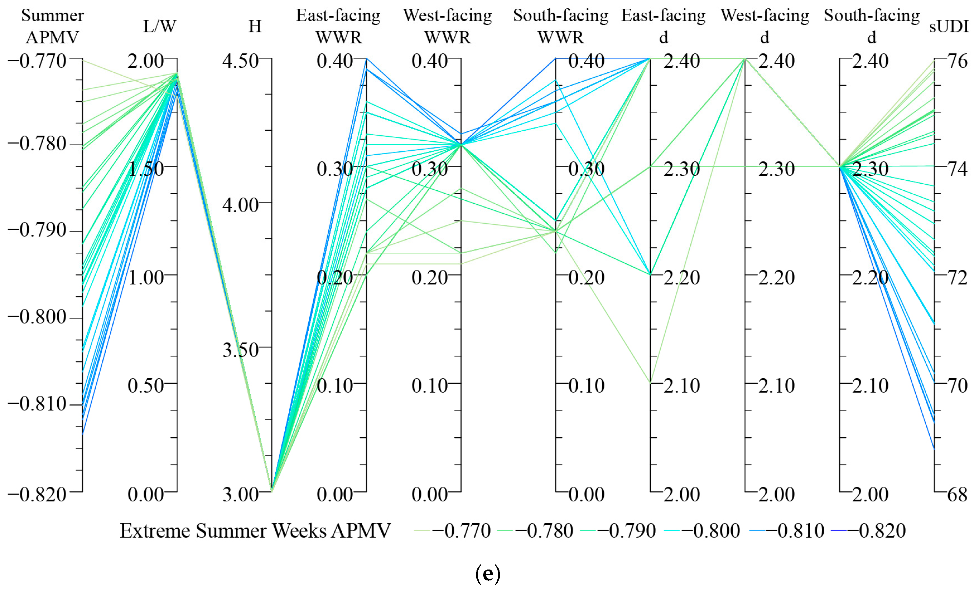
The summer optimization primarily targeted minimizing the indoor thermal environment index (APMV) while concurrently considering the daylight environment (sUDI). The core strategy involved “shading and ventilation”, with the building morphology exhibiting a trend towards elongation. The remaining parameters showed significant variations depending on the orientation (
Figure 12).
The optimization results converge within the range of 1.8:1 to 1.9:1, manifesting as an elongated rectangular form that is narrower along the east–west axis and wider along the north–south axis. This configuration promotes the creation of more extensive shaded areas, thereby reducing the absorption of solar radiation by ground surfaces and walls and consequently suppressing the heating effect of re-radiated heat on the air. Although the increased surface area of the east- and west-facing walls may lead to higher solar heat gain, this can be effectively mitigated through the subsequent application of shading components.
- 2.
Building Height (H)
The optimization results consistently converge to 3.0 m. A lower building height helps reduce the surface-to-volume ratio, minimizing the contact area with hot outdoor air and thereby enhancing thermal insulation performance. Furthermore, when cooling systems are operational, the smaller spatial volume facilitates more efficient cooling, contributing to energy-efficient operation.
- 3.
Window-to-Wall Ratio (WWR)
The optimized WWR ranges from 0.30 to 0.40 for east-facing facades and from 0.34 to 0.40 for south-facing facades. As natural ventilation serves as the primary cooling strategy during summer, moderately increasing the window area enhances airflow. The high solar altitude angle in summer minimizes direct solar radiation on south-facing walls, permitting larger window openings to concurrently address ventilation and daylighting requirements. Conversely, the WWR for west-facing facades is confined to a narrower range of 0.32–0.33, attributable to the significant solar heat gain from afternoon sun exposure, necessitating a critical balance between ventilation and solar shading. It is noteworthy that while a higher WWR facilitates ventilation, it may also admit excessive direct sunlight, potentially causing glare and localized overheating, which consequently compromises the sUDI metric.
- 4.
Shading Component Dimensions (d)
The optimized dimensions concentrate at 2.4 m for east- and west-facing facades, and 2.3 m for the south-facing facade. Solar shading is of paramount importance in summer, requiring control of solar radiation at the source. The larger dimensions for east and west orientations are typically necessary to defend against low-angle solar radiation. Appropriately designed shading components not only effectively block direct solar radiation but can also transform it into softened diffuse daylight. This enhances the spatial Useful Daylight Illuminance (sUDI) area while maintaining ventilation, thereby mitigating the conflict between large window openings and daylighting quality.
In summary, the summer optimization results indicate that the optimal courtyard length-to-width ratio (L/W) is concentrated within the range of 1.8:1 to 1.9:1. This corresponds to an elongated rectangular form, narrower on the east–west axis and wider on the north–south axis, which facilitates the formation of more shaded areas during summer, reduces solar radiation absorption, and promotes north–south natural ventilation. The building height (H) was optimized to 3.0 m; a lower story height helps reduce the building’s surface area for heat exchange with the external environment, thereby enhancing overall thermal insulation performance. Regarding the Window-to-Wall Ratio (WWR), distinct functional differentiation is observed across orientations: the east and south facades feature larger openings, concentrated within the ranges of 0.30–0.40 and 0.34–0.40, respectively, aiming to maximize natural ventilation, whereas the west-facing WWR is controlled at a lower level of 0.32–0.33 to effectively mitigate significant heat gain from afternoon sun exposure. The shading component depth (d) for all orientations falls within the substantial range of 2.3–2.4 m, capable of blocking high-angle direct sunlight while maintaining good diffuse daylighting indoors, thus achieving a balance between controlling solar heat gain and ensuring visual comfort (
Figure 13).
4.2. Analysis of Winter Optimization Results
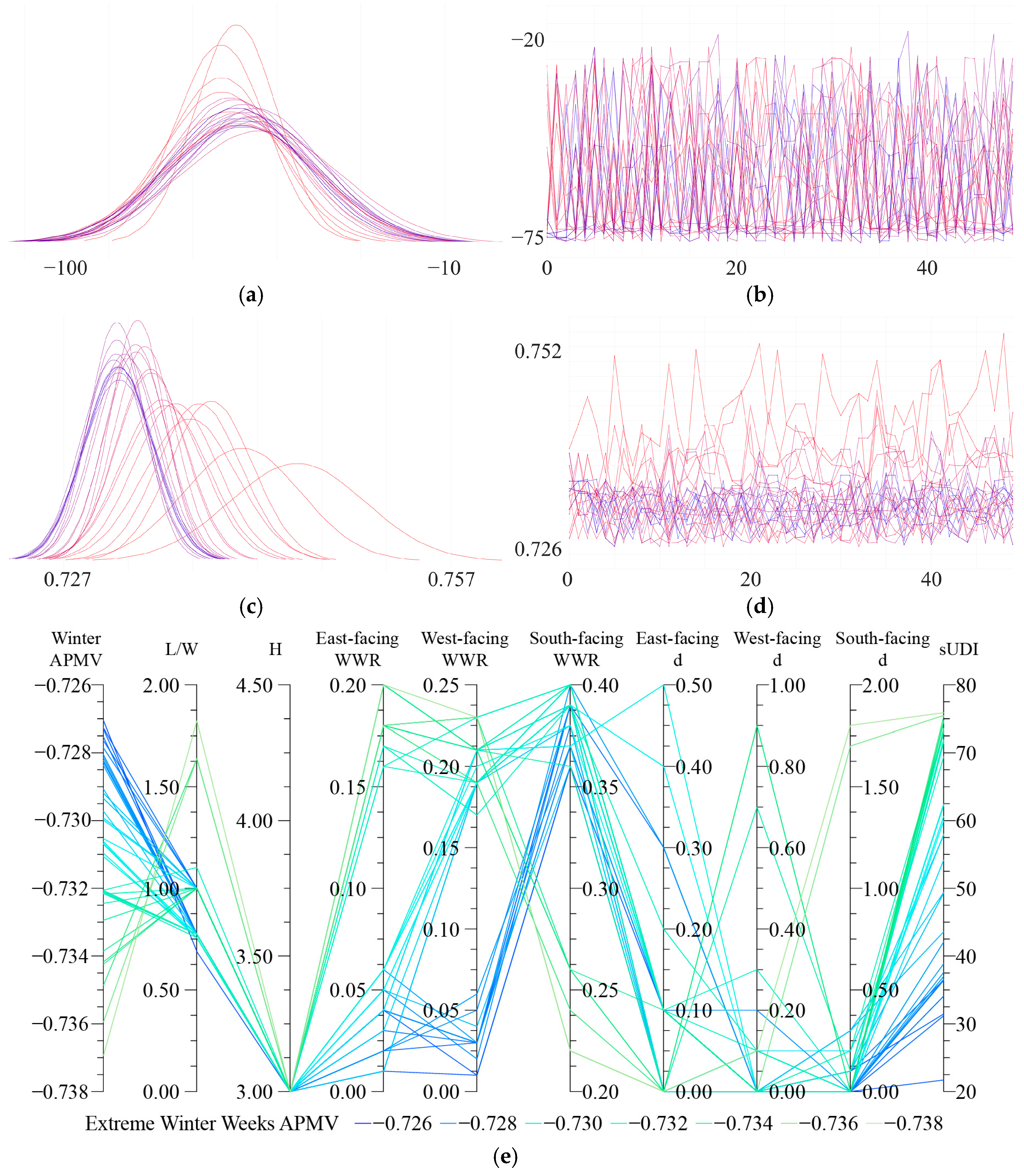
The primary objective of the winter optimization was to maximize the indoor thermal environment index (APMV) while concurrently considering the daylighting performance (sUDI). In contrast to the summer strategy emphasizing “shading and ventilation”, the core winter design strategy shifts towards “thermal insulation and solar heat gain”. The optimized building configuration and component parameters exhibit a distinct convergence trend (
Figure 14).
The optimization results converge within a range of 0.7:1 to 1:1, manifesting as a form that is either nearly square or a rectangle wider along the east–west axis and narrower along the north–south axis. This layout facilitates a wider south-facing elevation, thereby maximizing solar radiation exposure and enhancing indoor heat gain during winter.
- 2.
Building Height (H)
The optimization results consistently converge at 3.0 m. A lower building height helps reduce the surface-to-volume ratio, improving the thermal insulation performance of the building envelope. Concurrently, it reduces the volume of air requiring heating, which is conducive to lowering energy consumption and accelerating the indoor temperature rise.
- 3.
Window-to-Wall Ratio (WWR)
Significant differences are observed between the east/west-facing and south-facing WWR. The optimized WWR for east and west façades is concentrated in the range of 0.01–0.06, with lower values correlating with higher APMV scores. This is because east and west windows contribute minimally to solar heat gain in winter but represent significant weak points for heat loss. Consequently, minimizing fenestration on these orientations is a key measure for winter thermal insulation. However, excessively small windows compromise daylighting performance (sUDI), potentially necessitating supplemental artificial lighting. In contrast, the south-facing WWR is concentrated between 0.36 and 0.40, with larger values leading to improvements in both APMV and sUDI. The south façade receives the maximum solar radiation during winter; therefore, increasing the south window area serves as the core measure for passive solar heating, significantly enhancing indoor temperatures while providing ample natural daylight.
- 4.
Shading Component Dimensions (d)
The dimensions of shading components for all orientations tend towards the minimum values. Specifically, the optimized dimension (d) for east- and west-facing rooms concentrates in the range of 0–0.1 m, while for south-facing rooms, it ranges from 0 to 0.3 m. The low solar altitude angle in winter means shading components would block desirable direct solar radiation from entering the interior, which is detrimental to passive solar heating. Although increasing the shading size can improve the sUDI to some extent, it concurrently reduces the APMV. Therefore, priority should be given to thermal insulation over daylighting in winter, with shading minimized to maximize beneficial solar heat gain.
In summary, the winter optimization results demonstrate that the optimal courtyard length-to-width ratio (L/W) is concentrated within the range of 1:1 to 0.7:1, corresponding to a nearly square or slightly east–west elongated rectangular form. This configuration helps maximize the south-facing exposure area to capture winter solar radiation to the greatest extent. The building height (H) was optimized to 3.0 m; the lower story height effectively reduces the surface-to-volume ratio, thereby minimizing heat loss through the building envelope and enhancing overall thermal insulation performance. Regarding the Window-to-Wall Ratio (WWR), significant functional differentiation is observed across orientations: the south-facing WWR is concentrated in the higher range of 0.36–0.40, aiming to fully utilize passive solar heating, whereas the east and west orientations employ minimal WWR strategies (0.01–0.06) to drastically minimize heat loss through these facades. The shading component depth (d) for all orientations is maintained within a short range of 0–0.3 m to avoid blocking the low-angle winter direct sunlight, thereby ensuring sufficient solar heat gain indoors (
Figure 15).
4.3. Analysis of Integrated Winter–Summer Results
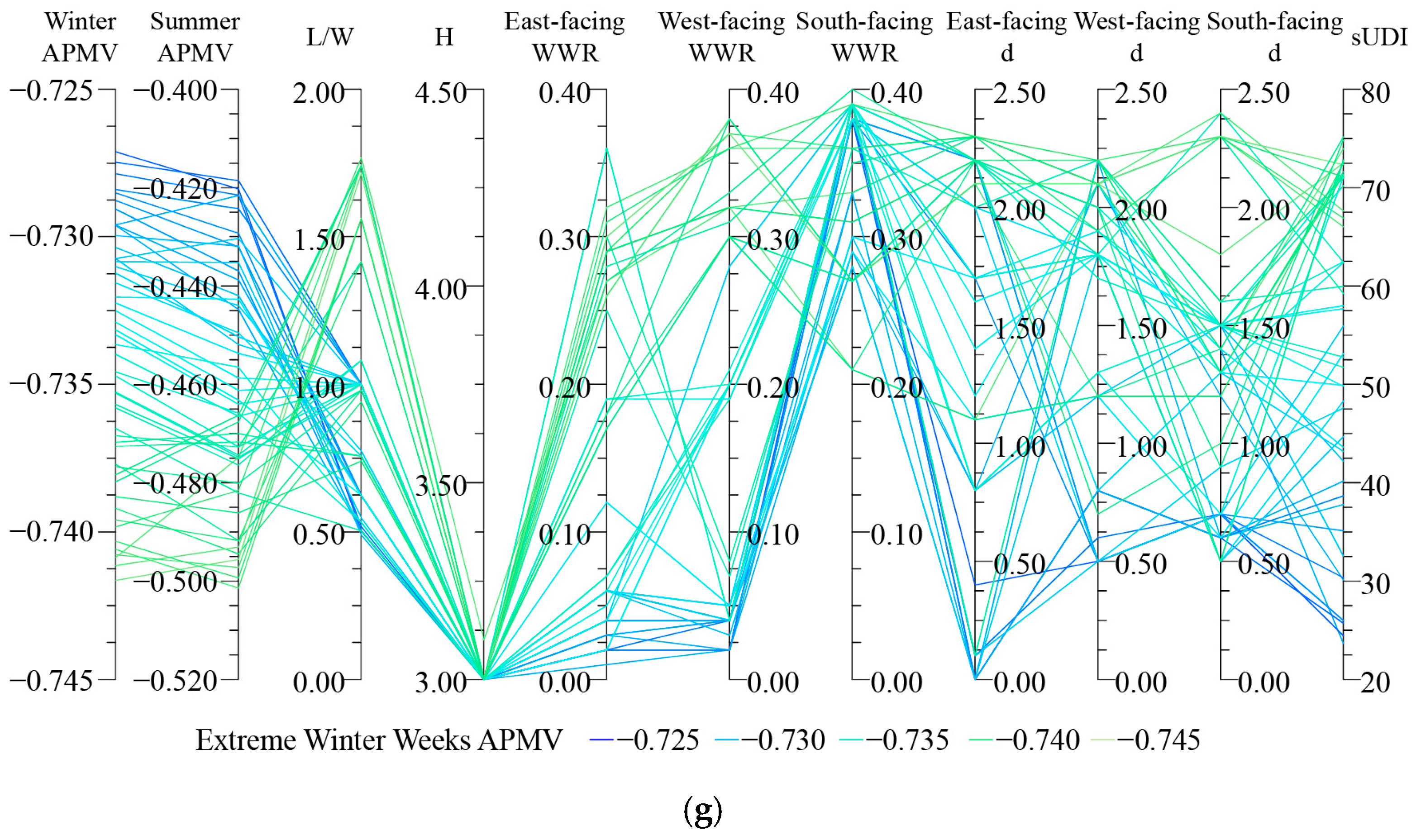
The integrated winter–summer optimization aims to achieve the comprehensive objectives of high winter APMV, low summer APMV, and favorable daylighting conditions (sUDI) simultaneously, seeking a balanced solution that delivers optimal annual performance. The results indicate that fixed design strategies are inadequate to concurrently satisfy the divergent requirements of winter (“insulation and heat gain”) and summer (“shading and ventilation”). Consequently, the optimal solution demonstrates a strategic approach that prioritizes winter performance as the foundation, while incorporating adaptive design at key locations to accommodate summer needs (
Figure 16).
The optimization results primarily converge within the range of 1.1:1 to 0.9:1, manifesting as a regular, nearly square form. Compared to elongated courtyards, a square configuration offers superior morphological stability and spatial balance. While it is less efficient than a north–south elongated courtyard in providing summer shading, this can be compensated for through the synergistic design of fenestration strategies and shading components, thereby achieving optimization of the overall annual performance.
- 2.
Building Height (H)
All optimization results converge at 3.0 m, further validating the dual advantages of a lower building height in reducing the surface-to-volume ratio and enhancing the thermal insulation performance of the building envelope. This configuration is well-suited for meeting the climatic adaptability requirements of both winter and summer seasons.
- 3.
Window-to-Wall Ratio (WWR)
The results reveal distinct, orientation-specific design characteristics. The WWR for east-facing rooms is minimal, concentrated in the range of 0.02–0.07. This prioritizes winter thermal insulation, as these orientations receive limited solar heat gain while being significant sources of heat loss. The WWR for west-facing facades is moderate, ranging from 0.19 to 0.21, seeking a balance between controlling undesirable afternoon solar gain and allowing potential for summer ventilation. The south-facing WWR is the largest, between 0.38 and 0.40, as it maximizes passive solar heating in winter while also promoting natural ventilation in summer, offering the highest overall benefits. However, this requires integration with effective shading to mitigate associated risks of glare and overheating. Notably, a trend of decreasing sUDI is observed with increasing WWR, highlighting the critical necessity of shading design for maintaining visual comfort under the region’s intense solar radiation conditions.
- 4.
Shading Component Dimensions (d)
The shading dimensions for east and south orientations are moderate, ranging from 1.20 to 1.70 m and 1.30–1.50 m, respectively. This design effectively blocks high-angle summer sun while permitting the entry of low-angle winter sunlight, thereby achieving a balanced performance across seasons. In contrast, west-facing rooms require the largest shading dimensions, between 1.70 m and 2.10 m, to mitigate intense afternoon solar radiation and prevent overheating during summer.
In conclusion, the integrated winter–summer optimization results demonstrate a systematic balancing strategy aimed at achieving optimal overall performance amidst seasonal contradictions. The optimized courtyard length-to-width ratio (L/W) concentrates within the range of 1.1:1 to 0.9:1. This nearly square configuration provides a balanced spatial foundation for both seasons, avoiding excessive solar heat gain in summer while ensuring adequate south-facing exposure for radiant heat capture in winter. The building height (H) is consistently optimized at 3.0 m, where the reduced surface-to-volume ratio simultaneously enhances thermal insulation in winter and heat resistance in summer.
Regarding the Window-to-Wall Ratio (WWR), distinct strategic differentiation is observed across orientations: the south-facing WWR concentrates in the high range of 0.38–0.40 to maximize passive solar heating in winter while facilitating summer ventilation; the west-facing WWR is moderated to 0.19–0.21, balancing limited ventilation intake with strict control over afternoon solar heat gain; and the east-facing WWR is minimized to 0.02–0.07 to drastically reduce heat loss through this orientation during winter.
For shading design, the shading component depth (d) maintains moderate dimensions across all orientations, with slightly smaller values for east and south facades (1.20–1.70 m) and larger values for the west facade (1.70–2.10 m). This achieves a seasonal balance between permitting solar access in winter and providing effective shading in summer (
Figure 17).
5. Discussion
In summary, there exists a fundamental discrepancy in the optimization objectives for the thermal environment between winter and summer, leading to distinctly different required technical strategies. This indicates an inherent contradiction in achieving the ideal condition of “warm in winter and cool in summer” within a single, unified architectural space. However, the optimization results considering both seasons demonstrate that implementing differentiated designs for different rooms within the same courtyard can effectively resolve this seasonal demand conflict. This finding shows a high degree of alignment with the spontaneously emerging “Seasonal Room Rotation” living pattern observed in current rural residences, thereby providing scientific validation and a theoretical basis for its empirical validity and practical application.
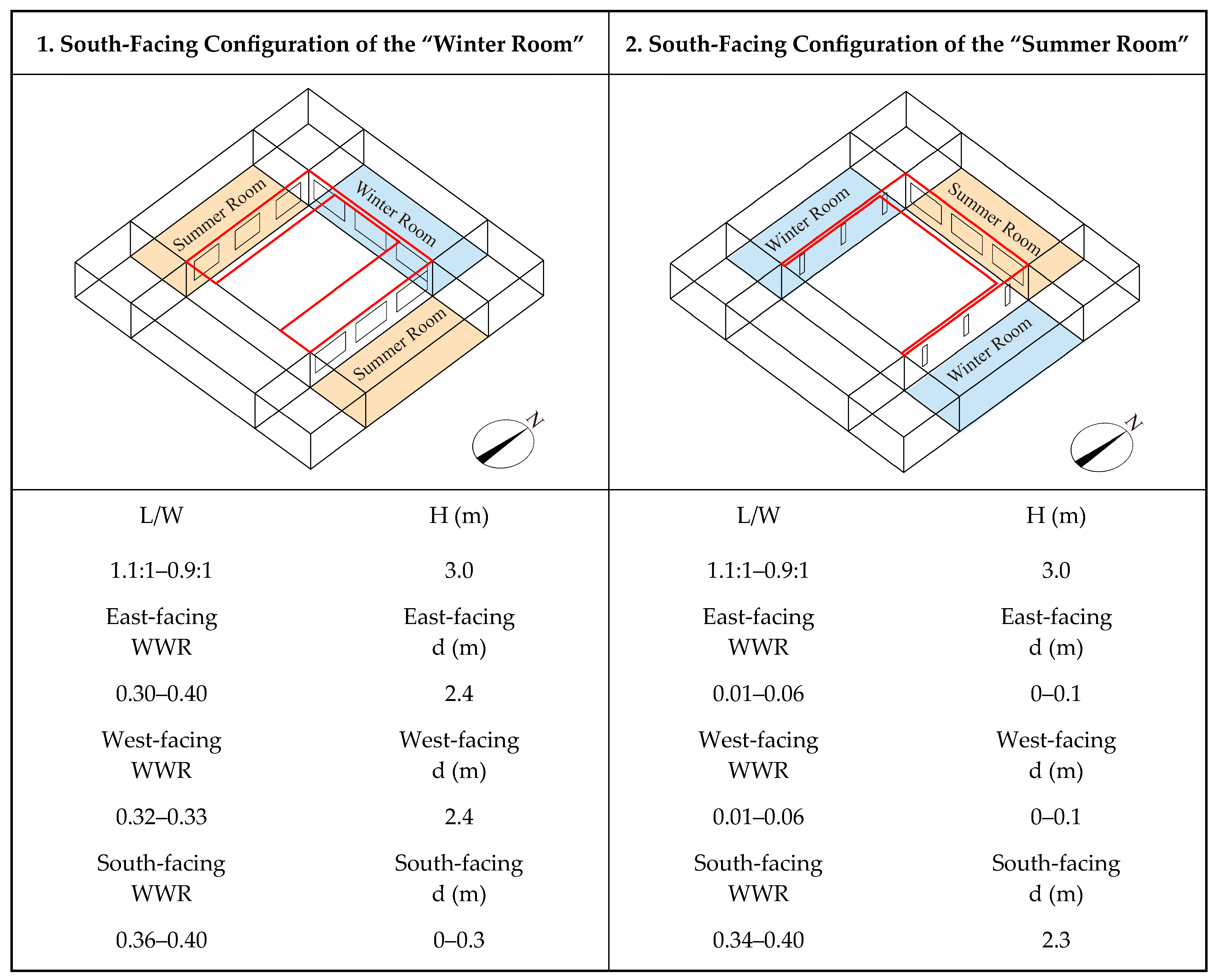
Based on this finding, this study proposes an innovative design strategy: functionally differentiate building spaces based on their season of use, establishing distinct “Winter Rooms” and “Summer Rooms”, and enhance their comprehensive performance in winter insulation and summer cooling through systematic parameter optimization. The specific design guidelines are as follows:
It is recommended to adopt a nearly square courtyard morphology and maintain a relatively low building height to establish a stable physical foundation accommodating both winter and summer performance.
- 2.
Design Strategies for “Summer Rooms”
The core objective is to enhance summer comfort.
Orientation-Adaptive Strategy: Regardless of whether the room is situated on the south or east/west orientation, a uniform design approach of “high window-to-wall ratio + deep shading components” can be employed. A high window-to-wall ratio facilitates natural ventilation, while substantial shading components effectively block solar radiation, achieving passive cooling.
- 3.
Design Strategies for “Winter Rooms”
The core objective is to enhance winter comfort.
South-facing Placement: Winter rooms should be preferentially located on the south-facing side, employing a combined strategy of a “large window-to-wall ratio + minimal shading” to maximize solar heat gain during winter.
East/West-facing Placement: If situated on the east or west orientations, a strategy of “small window-to-wall ratio + minimal shading” should be adopted, focusing on reducing heat loss through the building envelope and enhancing thermal insulation performance.
Specific technical parameter recommendations are provided in
Figure 18. This “Seasonal Room Rotation” model shifts the issue of seasonal adaptation from an internal performance trade-off within a single room to a matter of spatial resource allocation at the whole-building level, offering a systematic and operable design paradigm for the renewal of rural residences in complex climatic conditions.
6. Conclusions
Focusing on the challenge of seasonal climate adaptation faced by rural residences in the Hexi Corridor region amidst population contraction, this study systematically investigated pathways for enhancing green performance under the “Seasonal Room Rotation” living pattern through field surveys, climate analysis, and multi-objective optimization methods. The main conclusions and findings are as follows:
Utilizing a multi-objective optimization approach, this study has, for the first time, established a quantified design parameter system applicable to the “Seasonal Room Rotation” mode in the Hexi Corridor region. The results demonstrate that: in terms of building morphology, a nearly square courtyard form combined with a low building height forms the spatial foundation accommodating both winter and summer performance; regarding fenestration design, differentiated window-to-wall ratios across orientations effectively balance the demands for heat gain, ventilation, and insulation; concerning shading design, moderate shading depths reconcile the conflicting seasonal requirements for solar radiation. This parameter system provides a systematic design solution to the inherent contradiction between winter and summer performance within a single space.
- 2.
Research Contributions
At the theoretical level, this study elevates the issue of climate adaptation from an internal compromise within individual rooms to the allocation of spatial resources at the holistic building level, providing a new theoretical perspective for rural housing research. Methodologically, it establishes a research framework that integrates multi-objective optimization with regional wisdom, offering a replicable technical pathway for enhancing the performance of vernacular architecture. In practical terms, the developed design parameter system can directly inform the green construction and energy-efficient retrofitting of rural residences in the severe cold regions of Northwest China, holding significant application value for promoting the sustainable development of regional human settlements.
- 3.
Generalizability Findings
The “Seasonal Room Rotation” design concept demonstrates broad applicability potential. Its core principle of spatial functional differentiation can be extended to all regions with significant seasonal climate variations, offering a novel approach to resolving building adaptability challenges in similar environmental contexts. Furthermore, the multi-objective optimization methodological framework established in this study exhibits strong adaptability; by adjusting regional climate parameters and construction constraints, it can provide customized technical pathways for the green renewal of rural housing in different geographical areas.
- 4.
Research Limitations and Future Prospects
This study has several aspects that require further refinement. Regarding the research scope, it primarily focused on traditional courtyard-style dwellings, and the applicability of its conclusions to other building typologies requires further verification. Methodologically, the analysis relied predominantly on simulations, with limited field monitoring data. Consequently, future research will develop in three key directions: first, expanding the research sample to include diverse geographical regions and building types to validate the universality of the design paradigm; second, conducting empirical studies by constructing demonstration units and implementing long-term environmental monitoring to establish a complete “design-monitoring-feedback” research loop; third, exploring integrated innovations that combine spatial configuration models with new green technologies to develop more comprehensive technical systems for the sustainable renewal of rural housing.
Author Contributions
Conceptualization, L.S. and B.G.; methodology, L.S. and D.Y.; software and validation, L.S. and S.L.; formal analysis, L.S.; investigation, L.S. and H.Y.; data curation, L.S. and H.Y.; writing—original draft preparation, L.S.; writing—review and editing, L.S.; funding acquisition, B.G.; visualization, L.S.; supervision, B.G.; project administration, B.G. All authors have read and agreed to the published version of the manuscript.
Funding
This research was funded by the National Natural Science Foundation of China (Grant No. 52178027), “The Synergistic Mechanism of ‘Tectonics-Culture’ and Design Methods for Modern Urban and Rural Dwellings in the Loess Plateau-Gully Region”, and the Shaanxi Provincial Universities Youth Innovation Team Support Project (2022–2025).
Data Availability Statement
Data are contained within the article.
Acknowledgments
The authors would like to thank all the anonymous reviewers and editors who contributed their time and knowledge to this study.
Conflicts of Interest
The authors declare no conflicts of interest.
References
- Li, B.H.; Liu, P.L.; Dou, Y.D. Self-Organization Evolution Mechanism of Rural Human Settlement Environment System. Econ. Geogr. 2014, 34, 130–136. [Google Scholar]
- The State Council Information Office of the People’s Republic of China. Press Conference on China’s National Economic Performance in 2024. 17 January 2025. Available online: https://www.gov.cn/lianbo/fabu/202501/content6999424.htm (accessed on 6 October 2025).
- Huang, H.; Yang, G.Q.; Misselwitz, P.; Hannes, L. “Post-Rural Urbanization” and Rural Revitalization: Contemporary German Rural Planning Exploration and Its Enlightenment to China. City Plan. Rev. 2017, 41, 111–119. [Google Scholar]
- Wen, T.J. Will Urbanization Trigger a Chinese Economic Crisis? Theor. Learn. 2015, 1, 40–41. [Google Scholar]
- Hu, H.J.; Zhang, J.X. Rural Planning Transformation and Governance Innovation “Beyond Smart Shrinkage”: International Experience and Localized Construction. Urban Plan. Int. 2022, 37, 50–58. [Google Scholar]
- National Bureau of Statistics of China. China Statistical Yearbook; China Statistics Press: Beijing, China, 2024.
- Pu, A. Information Collected Door-to-Door. China Construction News, 6 January 2023; p. 001. [Google Scholar]
- Jiao, L.S.; Zhang, M. Causes of Vacancy and Abandonment in Shrinking Villages and Smart Shrinkage Planning Strategies: Field Investigation Based on Typical Villages in Eastern Henan. Econ. Geogr. 2021, 41, 221–232. [Google Scholar]
- Liu, Y.S.; Zhang, Y.F.; Lu, Q.; Long, H.L.; Zhang, H.Y.; Deng, X.Z.; Chen, Y.F.; Zhu, X.H.; Yan, M.C.; Lu, C.X.; et al. Research Report on Rural Development in China: Rural Hollowing and Its Remediation Strategies; Science Press: Beijing, China, 2011. [Google Scholar]
- Long, H.L.; Liu, Y.S. A Brief Background to Rural Restructuring in China: A Forthcoming Special Issue of Journal of Rural Studies. J. Geogr. Sci. 2015, 25, 1279–1280. [Google Scholar] [CrossRef]
- Gansu Provincial Bureau of Statistics; NBS Survey Office in Gansu. Gansu Statistical Yearbook 2024; China Statistics Press: Beijing, China, 2024.
- Editorial Committee of Gansu Rural Yearbook. Gansu Rural Yearbook 2024; China Statistics Press: Beijing, China, 2024. [Google Scholar]
- Popper, D.E.; Popper, F.J. Small Can be Beautiful: Coming to Terms with Decline. Plan. Mag. 2002, 68, 20–23. [Google Scholar]
- Peters, D.J.; Hamideh, S.; Zarecor, K.E.; Ghandour, M. Using Entrepreneurial Social Infrastructure to Understand Smart Shrinkage in Small Towns. J. Rural Stud. 2018, 64, 39–49. [Google Scholar] [CrossRef]
- Newman, G.; Hollander, J.B.; Lee, R.J.; Gu, D.; Kim, B.; Lee, R.J.; Horney, J.A.; Bearfield, D.; Li, Y. Smarter Shrinkage: A Neighborhood-Scaled Rightsizing Strategy Based on Land Use Dynamics. J. Geovis. Spat. Anal. 2018, 2, 11. [Google Scholar] [CrossRef]
- Jiao, B.F. Analysis of the Current Situation and Characteristics of Japan’s Depopulated Areas Accompanying Rapid Economic Growth. China Rural Econ. 2004, 8, 73–79. [Google Scholar]
- Matanle, P. Shrinking Sado: Education, Employment and the Decline of Japan’s Rural Regions. In Shrinking Cities—Complete Works 3 Japan; Project Office Philipp Oswalt: Berlin, Germany, 2008. [Google Scholar]
- Feldhoff, T. Shrinking Communities in Japan: Community Ownership of Assets as a Development Potential for Rural Japan. Urban Des. Int. 2013, 18, 99–109. [Google Scholar] [CrossRef]
- Sysssner, J.; Meijer, M. Informal Planning in Depopulating Rural Areas. Eur. Countrys. 2017, 9, 458–472. [Google Scholar] [CrossRef]
- Anne, T.; Gertrud, J. Translating a Wicked Problem: A Strategic Planning Approach to Rural Shrinkage in Denmark. Landsc. Urban Plan. 2016, 154, 29–44. [Google Scholar] [CrossRef]
- Naldi, L.; Nilsson, P.; Westlund, H.; Wixe, S. What is Smart Rural Development? J. Rural Stud. 2015, 40, 90–101. [Google Scholar] [CrossRef]
- Pužulis, A.; Kūle, L. Shrinking of Rural Territories in Latvia. Eur. Integr. Stud. 2016, 10, 90–105. [Google Scholar] [CrossRef]
- Duan, D.G.; Liu, X.; Ye, J.; An, N. Rural Shrinkage Trends and Pathways in the Guanzhong Region: Investigation Based on Heyang County. Small Towns Cities 2020, 38, 77–84. [Google Scholar]
- Li, X.H. Discussion on Rural Spatial Planning Strategies Based on Smart Shrinkage: A Case Study of Yueyang City, Hunan Province. In Vital Cities, Beautiful Human Settlements: Proceedings of the 2019 China Urban Planning Annual Conference (18 Rural Planning); China Urban Planning Society: Chongqing, China, 2019; pp. 1894–1902. [Google Scholar]
- You, L.; Chen, C. Practical Exploration of “Smart Shrinkage” in Rural Human Settlement Space: A Case Study of the Overall Plan Implementation for New Rural Communities in Q City. City Plan. Rev. 2018, 42, 113–118. [Google Scholar]
- Xie, Z.W.; Li, H.P. On the “Smart Shrinkage” of Rural Areas and Its Realization Path. In Urban–Rural Governance and Planning Reform: Proceedings of the 2014 China Urban Planning Annual Conference (14 Small Towns and Rural Planning); China Urban Planning Society: Fuzhou, China, 2014; pp. 801–810. [Google Scholar]
- Zhu, Q.J. Spatial Optimization Strategies for Villages in Severe Cold Regions from the Perspective of Smart Shrinkage. Master’s Thesis, Harbin Institute of Technology, Harbin, China, 2017. [Google Scholar]
- Li, H.B.; Liu, M.D.; Hu, X.L.; Chen, X. Changing Characteristics and Classification of Rural Human Settlement Space from the Perspective of Smart Shrinkage: A Case Study of Changshu City, Jiangsu Province. Geogr. Res. 2020, 39, 939–955. [Google Scholar]
- Jiao, L.S. Study on the Transformation Mode and Planning Strategy of Urban-Rural Space in Traditional Agricultural Counties of Eastern Henan. Ph.D. Thesis, Xi’an University of Architecture and Technology, Xi’an, China, 2019. [Google Scholar]
- Qin, X.Z.; Du, Z.W. Contraction and Planning Response of Rural Urbanization Areas under the Financial Crisis: A Case Study of Shangsha Village, Chang’an Town, Dongguan City. Planners 2017, 33, 33–38. [Google Scholar]
- Zhang, J.J.; Ye, J.; Liu, Q.Z.; Li, Q.L. Spatial Planning Strategies for Guangzhou’s Peripheral Villages Based on the “Smart Shrinkage” Theory. Planners 2018, 34, 77–85. [Google Scholar]
- Zhou, Y.C.; Luo, Z.D.; Geng, L. Aggregation Planning of Mountain Rural Settlements Based on “Smart Shrinkage”: A Case Study of Longquan Town, Yichang City, Hubei Province. Planners 2016, 32, 86–91. [Google Scholar]
- You, L. The Path of “Shrinkage” and “Smart Shrinkage” for Rural Human Settlement Space: Empirical Analysis, Theoretical Interpretation, and Value Choice. City Plan. Rev. 2018, 42, 61–69. [Google Scholar]
- Li, Y.Q.; Geng, H.; Gao, P. Exploring a New Town-Village Development Model Guided by “Smart Shrinkage”: A Case Study of Wangji Street, Wuhan. Small Towns Cities 2018, 4, 76–82. [Google Scholar]
- Liu, Y. Rural Planning and Construction from the Perspective of “Smart Shrinkage”. Hous. Real Estate 2018, 33, 219. [Google Scholar]
- Jing, X.P.; Chen, Y.H. Analysis of Rural Construction Transformation from the Perspective of Smart Shrinkage. In Sharing and Quality: Proceedings of the 2018 China Urban Planning Annual Conference (18 Rural Planning); China Urban Planning Society: Hangzhou, China, 2018; pp. 486–495. [Google Scholar]
- Zhao, M.; You, L.; Chen, C. On the “Smart Shrinkage” Orientation and Planning Strategies for Rural Human Settlement Space. City Plan. Rev. 2015, 39, 9–18+24. [Google Scholar]
- Ma, Y.B. Research on China’s Rural Construction and Planning Strategies from the Perspective of Smart Shrinkage. Beijing Plan. Rev. 2017, 2, 29–33. [Google Scholar]
- Cheng, Z.Q. Analysis of Rural Planning under the Guidance of “Smart Shrinkage” Theory. In Planning 60 Years: Achievements and Challenges: Proceedings of the 2016 China Urban Planning Annual Conference (15 Rural Planning); China Urban Planning Society: Shenyang, China, 2016; pp. 558–564. [Google Scholar]
- Guo, Y.; Liu, D.; Zhao, N.N.; Dong, Y.M.; Li, Z.G. Rural Development Transformation and Settlement System Planning Based on Smart Shrinkage: A Case Study of Wuhan City. J. Urban Reg. Plan. 2018, 10, 168–186. [Google Scholar]
- Wang, Y.C.; Wang, Y.Y.; Tu, H.J. Rural Spatial Development Strategies in Southern Jiangsu from the Perspective of Smart Shrinkage Theory. Planners 2017, 33, 39–44. [Google Scholar]
- Zou, Y.F.; He, G.Y.; Shan, T.; He, L.J. Research on Planning and Construction Countermeasures for Poor Mountainous Areas from the Perspective of “Smart Shrinkage”: A Case Study of Loufang Village, Fuping County. Small Towns Cities 2015, 12, 55–60. [Google Scholar]
- Du, Z.W.; Li, X. The Formation of Shrinking Cities and Planning Implications: Based on the Perspective of Neo-Marxist Urban Theory. Planners 2017, 33, 5–11. [Google Scholar]
- Qin, Y.G. Green Building in the Context of China’s National Conditions. Chin. Overseas Archit. 2005, 3, 4–5. [Google Scholar]
- Liu, J.P. Green Building: Practice in Western China; China Architecture & Building Press: Beijing, China, 2015. [Google Scholar]
- Song, Y.H. Integrated Design with Nature: Research on Eco-Effective Architectural Design; China Architecture & Building Press: Beijing, China, 2000. [Google Scholar]
- Song, Y.H.; Wang, J.L.; Zhu, N. Reflections on Passive Design Strategies for Indigenous Green Buildings in China. Archit. J. 2013, 7, 94–99. [Google Scholar]
- Song, Y.H. Debate on the Development of Indigenous Green Building Design in China. New Archit. 2013, 4, 5–7+4. [Google Scholar]
- Lin, B.R.; Wang, P.; Zhao, B.; Zhu, Y.X. Numerical Simulation Study on the Wind Environment of Traditional Courtyard Dwellings. Archit. J. 2002, 5, 47–48. [Google Scholar]
- Lin, B.R.; Tan, G.; Wang, P.; Song, L.; Zhu, Y.X.; Zhai, G.K. Field Measurement and Analysis of Summer Thermal Environment in Traditional Dwellings of Southern Anhui. J. Tsinghua Univ. (Sci. Technol.) 2002, 8, 1071–1074. [Google Scholar]
- Lin, B.R.; Li, Z.W. Environmental Performance Optimization Design Strategies for Climate-Adaptive Green Public Buildings. South Archit. 2013, 3, 17–21. [Google Scholar]
- Li, Y. Study on Rural Human Settlements in Ecologically Fragile Areas of Shaanxi-Gansu-Ningxia. Ph.D. Thesis, Xi’an University of Architecture and Technology, Xi’an, China, 2011. [Google Scholar]
- Zhao, B. Research on Climate Adaptability of Architectural Forms of Traditional Dwellings in Hexi Corridor. Master’s Thesis, Chang’an University, Xi’an, China, 2016. [Google Scholar]
- Zhang, Z.W.; Jin, Y.B.; Wang, J. Construction Wisdom and Renewal Research of Vernacular Dwellings in Wuwei Area of Hexi Corridor. Archit. Cult. 2015, 7, 99–102. [Google Scholar]
- Chen, J.; Wang, X.R.; Li, C. Research on Passive Energy-Saving Design of Dwellings in Severe Cold and Cold Regions of Gansu. Interior Des. Constr. 2022, 2, 128–129. [Google Scholar]
- He, J.Z. Research on Climate Adaptation Strategies and Design Applications of Traditional Dwellings in Hexi Corridor Region. Ph.D. Thesis, Xi’an University of Architecture and Technology, Xi’an, China, 2020. [Google Scholar]
- He, J.Z.; Chen, J.; Zhang, Q.; Wang, Y. Energy Consumption Optimization and Renewal of Rural Dwellings in Hexi Corridor. World Arch. 2022, 3, 92–97. [Google Scholar]
- Shu, Z.W. Research on Green Renewal Design of Rammed Earth Dwellings in Minqin County, Wuwei City. Master’s Thesis, Xi’an University of Architecture and Technology, Xi’an, China, 2022. [Google Scholar]
- Sun, Y. Research on Construction Mode and Design Application of Fortress Dwellings in Wuwei Rui’an Fort. Master’s Thesis, Xi’an University of Architecture and Technology, Xi’an, China, 2020. [Google Scholar]
- Qi, H.Y. Redevelopment of Architectural Forms in the Desertified Area of Dunhuang. Master’s Thesis, Tsinghua University, Beijing, China, 2004. [Google Scholar]
- GB50178-93; Ministry of Construction of the People’s Republic of China. Standard for Building Climate Zoning. China Planning Press: Beijing, China, 1993.
- Wang, B.; Li, L.P.; Xia, Q.; Yao, Y.B.; Hu, L.L.; Liu, M.C. Temporal and Spatial Distribution Characteristics of Solar Radiation and Solar Energy Resource Assessment in Hexi Corridor. Desert Oasis Meteorol. 2023, 17, 147–153. [Google Scholar]
- Meteorological Data Office, China Meteorological Data Service Center. Meteorological Dataset for Building Thermal Environment Analysis in China; China Architecture & Building Press: Beijing, China, 2005.
- ANSI/ASHRAE Standard 55-2004; Thermal Environmental Conditions for Human Occupancy. American Society of Heating, Refrigerating and Air-Conditioning Engineers: Atlanta, GA, USA, 2004.
- He, Q.; Wang, W.C.; Liu, J.P.; Yang, L. Climate Adaptability Analysis of Traditional Dwellings in Lhasa Based on Climate Consultant. Build. Sci. 2017, 33, 94–100. [Google Scholar]
- Shang, L.X.; Gao, B.; Sun, Y. Research on the Green Construction Wisdom of Traditional Rural Dwellings in Hexi Corridor Region. Archit. Creat. 2024, 5, 188–199. [Google Scholar]
- Shang, L.X.; Gao, B.; Zhao, G.X. Modern Application Strategies of the “Shading-Yang” Experience in Rural Dwellings in Hexi Corridor Region. Archit. Creat. 2025, 4, 173–182. [Google Scholar]
- Gong, M.G.; Jiao, L.C.; Yang, D.D.; Ma, W.P. Research on Evolutionary Multi-objective Optimization Algorithms. J. Softw. 2009, 20, 271–289. [Google Scholar] [CrossRef]
- Deb, K.; Pratap, A.; Agarwal, S.; Meyarivan, T. A Fast and Elitist Multiobjective Genetic Algorithm: NSGA-II. IEEE Trans. Evol. Comput. 2002, 6, 182–197. [Google Scholar] [CrossRef]
- Lai, W.X.; Deng, Z.M.; Zhang, X.J. Structural Dynamics Model Validation Based on Improved NSGA2 Multi-objective Optimization Algorithm. Chin. J. Comput. Mech. 2018, 35, 669–674. [Google Scholar]
- Shang, R.H.; Hu, Z.X.; Jiao, L.C.; Bai, J. Research on Application of Multi-objective Optimization Algorithm in Multi-class Classification. Acta Electron. Sin. 2012, 40, 2264–2269. [Google Scholar]
- Roudsari, M.S.; Pak, M. Ladybug: A Parametric Environmental Plugin for Grasshopper to Help Designers Create an Environmentally-Conscious Design. In Proceedings of the 13th International IBPSA Conference, Lyon, France, 25–30 August 2013. [Google Scholar]
- Kirimtat, A.; Koyunbaba, B.K.; Chatzikonstantinou, I.; Sariyildiz, S. Review of Simulation Modeling for Thermal Comfort Using PMV and PPD in EnergyPlus. Renew. Sust. Energ. Rev. 2016, 53, 23–49. [Google Scholar] [CrossRef]
- Alsukkar, M.; Ibrahim, A.; Eltaweel, A. Multi-Objective Optimization of Daylighting Systems for Energy Efficiency and Thermal-Visual Comfort in Buildings: A Review. Build. Environ. 2026, 288, 113921. [Google Scholar] [CrossRef]
- Manmatharasan, P.; Bitsuamlak, G.; Grolinger, K. AI-Driven Design Optimization for Sustainable Buildings: A Systematic Review. Energy Build. 2025, 332, 115440. [Google Scholar] [CrossRef]
- Motamedi, S.; Liedl, P. Integrative Algorithm to Optimize Skylights Considering Fully Impacts of Daylight on Energy. Energy Build. 2017, 138, 655–665. [Google Scholar] [CrossRef]
- Khidmat, R.P.; Fukuda, H.; Kustiani; Paramita, B.; Ma, Q.; Hariyadi, A. Investigation into the Daylight Performance of Expanded-Metal Shading Through Parametric Design and Multi-Objective Optimisation in Japan. J. Build. Eng. 2022, 51, 104241. [Google Scholar] [CrossRef]
- Kharvari, F. An Empirical Validation of Daylighting Tools: Assessing Radiance Parameters and Simulation Settings in Ladybug and Honeybee Against Field Measurements. Sol. Energy 2020, 207, 1021–1036. [Google Scholar] [CrossRef]
- Li, T.; Li, S.Q.; Lei, Z.D. Optimization of Shading Component Dimensions for Lhasa Dwellings from a Light-Thermal Coupling Perspective. World Archit. 2024, 9, 74–79. [Google Scholar]
- GB/T 50785-2012; Ministry of Housing and Urban-Rural Development of the People’s Republic of China. Evaluation Standard for Indoor Thermal and Humid Environment of Civil Buildings. China Architecture & Building Press: Beijing, China, 2012.
- Cui, C.R.; Shi, F.; Yang, X.; Zheng, Y. Performance Optimization Design of Climate-Adaptive Bio-Inspired Building Envelope Based on Light-Thermal Coupling. Architect 2024, 6, 45–58. [Google Scholar]
- Nabil, A.; Mardaljevic, J. Useful Daylight Illuminances: A Replacement for Daylight Factors. Energy Build. 2006, 38, 905–913. [Google Scholar] [CrossRef]
- GB/T 5699-2017; Standardization Administration of the People’s Republic of China. Daylighting Measurement Methods. China Architecture & Building Press: Beijing, China, 2017.
- Sun, C.; Zi, Y.; Han, Y.S. Parametric Simulation Study on Natural Daylighting Performance of Mezzanine Space in Office Buildings in Cold Regions. J. Hum. Settl. West China 2021, 36, 24–30. [Google Scholar]
- Fang, Y.; Cho, S. Design Optimization of Building Geometry and Fenestration for Daylighting and Energy Performance. Sol. Energy 2019, 191, 7–18. [Google Scholar] [CrossRef]
Figure 1.
Location map of the Hexi Corridor.
Figure 1.
Location map of the Hexi Corridor.
Figure 2.
Transformation of living patterns.
Figure 2.
Transformation of living patterns.
Figure 3.
Map of mean annual temperature in the Hexi Corridor.
Figure 3.
Map of mean annual temperature in the Hexi Corridor.
Figure 4.
Map of annual sunshine duration in the Hexi Corridor.
Figure 4.
Map of annual sunshine duration in the Hexi Corridor.
Figure 5.
Personal Thermal Sensation Vote.
Figure 5.
Personal Thermal Sensation Vote.
Figure 6.
Personal Thermal Preference Vote.
Figure 6.
Personal Thermal Preference Vote.
Figure 7.
Typical rural residence in the Hexi Corridor.
Figure 7.
Typical rural residence in the Hexi Corridor.
Figure 8.
Annual climate strategy analysis for the Hexi Corridor: (a) Psychrometric chart for Wuwei; (b) Psychrometric chart for Jiuquan; (c) Psychrometric chart for Yumen; (d) Psychrometric chart for Dunhuang.
Figure 8.
Annual climate strategy analysis for the Hexi Corridor: (a) Psychrometric chart for Wuwei; (b) Psychrometric chart for Jiuquan; (c) Psychrometric chart for Yumen; (d) Psychrometric chart for Dunhuang.
Figure 9.
Diagram of passive architectural strategies.
Figure 9.
Diagram of passive architectural strategies.
Figure 10.
Framework of the multi-objective optimization workflow.
Figure 10.
Framework of the multi-objective optimization workflow.
Figure 11.
Parametric model: The black mass represents the main building structure, and the red mass represents the shading components.
Figure 11.
Parametric model: The black mass represents the main building structure, and the red mass represents the shading components.
Figure 12.
Summer Optimization Results: (a) Variance diagram of the average indoor daylight environment; (b) Line chart of the indoor average daylight environment optimization process; (c) Variance diagram of the average APMV during the extreme summer week; (d) Line chart of the summer average APMV optimization process; (e) Parallel coordinate plot showing the relationship between independent variables and optimization objectives for the Pareto front solutions.
Figure 13.
Typical building morphology and optimal parameter ranges derived from summer optimization: The black massing represents the main building structure, and the red massing represents the shading components.
Figure 13.
Typical building morphology and optimal parameter ranges derived from summer optimization: The black massing represents the main building structure, and the red massing represents the shading components.
Figure 14.
Winter Optimization Results: (a) Variance diagram of the average indoor daylight environment; (b) Line chart of the indoor average daylight environment optimization process; (c) Variance diagram of the average APMV during the extreme winter week; (d) Line chart of the winter average APMV optimization process; (e) Parallel coordinate plot showing the relationship between independent variables and optimization objectives for the Pareto front solutions.
Figure 15.
Typical building morphology and optimal parameter ranges derived from winter optimization: The black massing represents the main building structure, and the red massing represents the shading components.
Figure 15.
Typical building morphology and optimal parameter ranges derived from winter optimization: The black massing represents the main building structure, and the red massing represents the shading components.
Figure 16.
Integrated Winter–Summer Results: (a) Variance diagram of the average indoor daylight environment; (b) Line chart of the optimization process for the average indoor daylight environment; (c) Variance diagram of the average APMV during the extreme summer week; (d) Line chart of the summer average APMV optimization process; (e) Variance diagram of the average APMV during the extreme winter week; (f) Line chart of the winter average APMV optimization process; (g) Parallel coordinate plot showing the relationship between independent variables and optimization objectives for the Pareto front solutions.
Figure 17.
Integrated winter–summer typical building morphology and optimal value ranges: The black massing represents the main building structure, and the red massing represents the shading components.
Figure 17.
Integrated winter–summer typical building morphology and optimal value ranges: The black massing represents the main building structure, and the red massing represents the shading components.
Figure 18.
Specific technical parameters for the “Seasonal Room Rotation” mode: the black massing represents the main building structure, and the red massing represents the shading components.
Figure 18.
Specific technical parameters for the “Seasonal Room Rotation” mode: the black massing represents the main building structure, and the red massing represents the shading components.
Table 1.
Specifications of field measurement equipment.
Table 1.
Specifications of field measurement equipment.
Instrument
Name | Model | Detector
Resolution | Temperature
Measurement
Range | Measurement
Accuracy | Noise Equivalent Temperature Difference | Equipment
Photograph |
|---|
HIKMICRO High-Precision Infrared Thermal Imager
(Hangzhou Microimage Software Co., Ltd., Hangzhou, China) | H21PRO+ | 384 × 288 pixels | −20 °C to 550 °C | ±2 °C or ±2% of reading (whichever is greater) | <50 mK | ![Buildings 15 04263 i001 Buildings 15 04263 i001]() |
Table 2.
Summary of summer thermal imaging measurement data.
Table 3.
Summary of winter thermal imaging measurement data.
Table 4.
Thermal parameters of the building envelope.
Table 4.
Thermal parameters of the building envelope.
| Construction | Material | Thickness
(mm) | Density
(kg/m3) | Thermal Conductivity
(W/(m·K)) | Specific Heat Capacity
(J/(kg·K)) |
|---|
| Wall | Clay | 400 | 2000 | 1.16 | 1010 |
| Roof | Clay | 200 | 2000 | 1.16 | 1010 |
| Ground | Clay Brick | 55 | 1700 | 0.76 | 1050 |
| Disclaimer/Publisher’s Note: The statements, opinions and data contained in all publications are solely those of the individual author(s) and contributor(s) and not of MDPI and/or the editor(s). MDPI and/or the editor(s) disclaim responsibility for any injury to people or property resulting from any ideas, methods, instructions or products referred to in the content. |
© 2025 by the authors. Licensee MDPI, Basel, Switzerland. This article is an open access article distributed under the terms and conditions of the Creative Commons Attribution (CC BY) license (https://creativecommons.org/licenses/by/4.0/).
