Article

Predicting Perceived Restorativeness of Urban Streetscapes Using Semantic Segmentation and Machine Learning: A Case Study of Liwan District, Guangzhou

Faculty of Innovation and Design, City University of Macau, Macau 999078, China
*
Author to whom correspondence should be addressed.
Buildings 2025, 15(20), 3671; https://doi.org/10.3390/buildings15203671 (registering DOI)
Submission received: 13 August 2025 / Revised: 4 October 2025 / Accepted: 10 October 2025 / Published: 12 October 2025

Abstract

Urban streetscapes are among the most frequently encountered spatial environments in daily life, and their restorative visual features have a significant impact on well-being. Although existing studies have revealed the relationship between streetscape environments and perceived restorativeness, there remains a lack of scalable, data-driven methods for quantifying such perception at the street level. This study proposes an interpretable and replicable framework for predicting streetscape restorativeness by integrating semantic segmentation, perceptual evaluation, and machine learning techniques. Taking Liwan District of Guangzhou as a case study, street-view images (SVIs) were collected and processed using the Mask2Former model to extract the following five key visual metrics: greenness, openness, enclosure, walkability, and imageability. Based on the Perceived Restorativeness Scale (PRS), an online questionnaire was designed from four dimensions (fascination, being away, compatibility, and extent) to score a random sample of images. A random forest model was then trained to predict the perceptual levels of the full dataset, followed by K-means clustering to identify spatial distribution patterns. The results revealed that there were significant differences in visual characteristics among high, medium, and low restorativeness street types. The proposed framework enables scalable, data-driven evaluation of perceived restorativeness across diverse urban streetscapes. By embedding perceptual metrics into large-scale urban analysis, the framework offers a replicable and efficient approach for identifying streets with low restorative potential—thus providing urban planners and policymakers with a novel tool for prioritizing street-level renewal, improving public well-being, and supporting perception-oriented urban design without the need for labor-intensive fieldwork.

1. Introduction

Urban streetscapes are among the most frequently encountered spatial environment in daily life. Beyond serving as transportation corridors, they function as key settings for walking, social interaction, and multisensory experience [1]. Streetscapes play a vital yet often overlooked role in promoting residents’ psychological well-being. Their long-term and high-frequency exposure may exert subtle yet accumulative effects on emotional regulation and psychological functioning [2]. However, compared to green spaces such as parks, the restorative potential of urban streetscapes remains underestimated and is still insufficiently addressed in both academic research and design practices.
Beyond serving as transit corridors, streets function as integral elements of urban ecological systems and restorative environments, as evidenced by policy directives and practical implementations. Recent studies have shown that urban arterials are increasingly integrated into green infrastructure networks, supporting both ecological continuity and psychological restoration. Streetscape studies have identified key visual features, such as greenness, openness, enclosure, walkability, and imageability, as influential factors shaping psychological responses to urban street environments [3,4,5]. These spatial indicators reflect how people perceive naturalness, spatial comfort, and movement affordances in everyday streetscapes. In parallel, a substantial body of environmental psychology literature is grounded in Attention Restoration Theory (ART) [6], which defines four core restorative dimensions: Being Away, Extent, Fascination, and Compatibility. Recent interdisciplinary efforts aim to explore how specific streetscape features map onto these psychological constructs, offering a theoretical foundation for perceptual prediction models [7]. To illustrate, Pall and Terry [8] used computer-generated images of streetscapes as stimuli prompting participants to evaluate the potential for psychological restoration elicited by these visuals. Their findings indicated that the presence of natural elements, such as increased tree coverage and flower beds, significantly enhanced perceptions of restorative potential, mediated by feelings of escape and fascination. Similarly, Barros [9] used a mixed method including interview, observation and Flickr data to investigate the restorative properties in commercial streets, and found that human-scale greenness, hospitable configurations, and good maintenance state were related to perceived restoration in commercial streets.
A new wave of global street transformation has emerged, emphasizing livability, inclusiveness, and health-oriented development. The “Complete Streets” initiative in the United States advocates for multimodal transport and pedestrian-friendly environments. However, its practical implementation often encounters fragmented municipal responsibilities and insufficient funding, resulting in inequitable sidewalk infrastructure across cities [10]. In the United Kingdom, the “Healthy Streets” framework positions streets as holistic environments that support physical and mental well-being, integrating concerns such as traffic safety, environmental quality, and social cohesion [11]. Spain’s “Superblocks” strategy reclaims public space from vehicles and reallocates it to pedestrians and cyclists, exemplifying a paradigmatic shift from car-oriented to people-centered spatial governance [12].
Echoing these international trends, several Chinese cities have started to focus on street environments and launched a series of street renewal initiatives. For instance, Shanghai has published its first street design guideline to formalize a people-centered, multi-objective framework integrating traffic, pedestrian, and ecological functions [13]. Guangzhou and Nanjing subsequently issued their own “Complete Street” manuals, which prioritize visual quality, pedestrian experience, and green connectivity, gradually shifting from traffic efficiency to spatial quality [14]. These cases collectively signify a transformation from ‘mobility-dominant street’ design toward “restorative streets” that integrate ecological resilience, psychological recovery, and social inclusion. The global convergence of such frameworks in both policy and practice underlines the growing emphasis on human-centered public space in the contemporary urban renewal agenda.
Urban spatial configurations significantly influence residents’ mental health, with high-quality urban environments reducing the prevalence of mental disorders and enhancing quality of life and social functioning [15]. Since the 1990s, scholars have demonstrated the health-promoting effects of green spaces, such as parks, tourist resorts, and university campuses, highlighting their psychological benefits. For instance, forest bathing in natural settings reduces stress and improves mood state, and it was found that its health benefit was effected through the immune system [16]. Natural elements within campus environments have been shown to facilitate attentional recovery [17], while localized landscape features in urban parks enhance residents’ psychological well-being through place attachment [18]. During the COVID-19 lockdown, community parks in Chinese cities emerged as vital green sanctuaries, significantly contributing to stress mitigation and psychological tension alleviation among residents [19]. Other studies have revealed how recreational green spaces promote pro-environmental behavior via mechanisms of place dependence and identity [14]. The restorative benefits of parks and natural environments have been widely examined, while streetscapes, where people spend a substantial portion of their everyday life, have received far less attention in this aspect. The cumulative psychological impact of continuous visual stimuli in these everyday street settings remains underexplored and underutilized in environmental psychology and design.
Existing approaches often rely on field surveys or controlled visual stimuli, such as photo-based rating tasks [2]. Despite the irreplaceable strengths of traditional methods, such as in-depth fieldwork and subjective questionnaires, their inherent limitations are becoming increasingly evident [20]. These approaches were labor-intensive, spatially constrained, and often reliant on small sample sizes, making it difficult to comprehensively evaluate the vast variability of urban environments [21]. With the rapid advancement of computer vision and spatial data analysis techniques, it has become increasingly feasible to model perceptual experiences directly from large-scale street-view imagery [1,18]. Techniques such as semantic segmentation, machine learning, and spatial regression now offer scalable, reproducible, and objective means to assess the psychological affordances of street environments [2,3]. Li et al. (2025) quantified urban street spatial quality in Jinan Old City by integrating deep learning models with street-view images, assessing walkability, green visibility, enclosure, and openness, offering a novel approach to evaluating psychological comfort in urban environments [22]. Some studies attempt to integrate PRS-based metrics and GIS modeling; they still largely depend on manually labeled perceptual data and seldom leverage the rich semantic structure embedded in visual street scenes, limiting the potential for more transferable and fine-grained perceptual prediction models [23].
To address the gaps, this study proposed a scalable and interpretable framework to predict the perceived restorativeness of urban streetscapes. The framework integrates semantic segmentation, perceptual annotation based on the Perceived Restorativeness Scale (PRS), and machine learning regression. Using Baidu street-view imagery from the Liwan District of Guangzhou, five semantic-level visual metrics, greenness, openness, enclosure, walkability, and imageability are extracted through deep learning-based segmentation [3,4,21]. Our contribution lies beyond segmentation per se. We translate segmented classes into visual metrics, couple them with multi-dimensional PRS rather than a single score, and localize outputs at the segment scale for targeting and prioritization. This provides a transparent route from pixel-level semantics to perception-relevant evidence that can be implemented in street-segment renewal. A sample of images is evaluated using a PRS-based questionnaire to generate perceptual scores, which are then used to train a Random Forest model. The predicted scores are further classified using K-means clustering to identify spatial patterns of perceived restorativeness at the street level [24].

2. Research Design and Methodology

2.1. Research Area

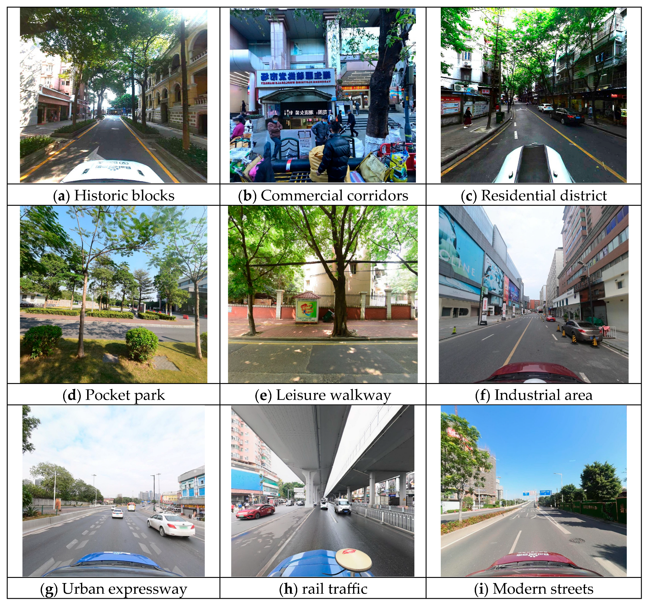
We selected the Liwan District of Guangzhou as the study area. Located in the western part of Guangzhou’s central urban area (Figure 1), Liwan covers approximately 59.10 km2, with 1,133,000 residents [25]. As one of the city’s earliest developed districts, Liwan exhibits a highly heterogeneous urban morphology, integrating traditional alleyways, aging residential areas, and rapidly modernizing street environments (Figure 2). Featuring both well-preserved historic neighborhoods and large-scale urban renewal demonstration projects, Liwan offers an ideal empirical setting for exploring visual perception differences and restorative mechanisms in the context of historic urban regeneration.

2.2. Research Framework Overview

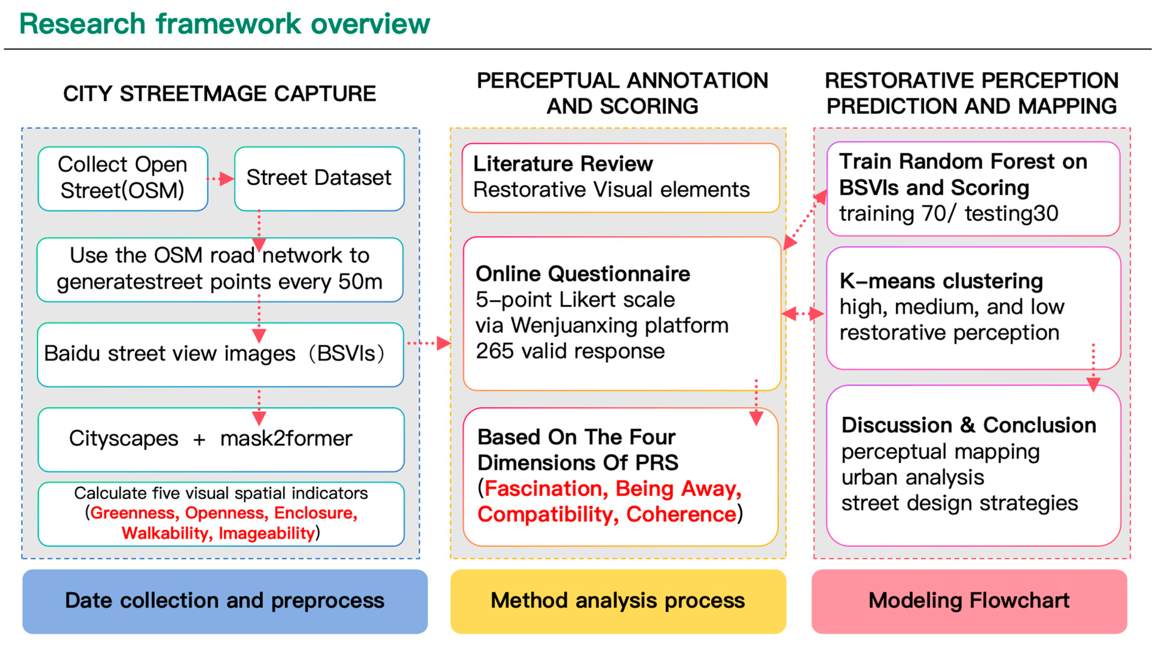
This study integrates semantic segmentation, machine learning, and human perceptual evaluation to construct a predictive model of perceived restorativeness in urban streetscapes. The complete workflow consists of six consecutive steps: sampling, semantic segmentation, PRS-based perceptual scoring, model training, restorativeness prediction, and spatial classification and visualization. The methodology is structured into three core modules (Figure 3).
(1)
Data Acquisition and Processing
A total of 1516 street-view locations were sampled from the Liwan District of Guangzhou. Four-directional images were captured at each point via the Baidu Street View API. These images were then processed using the Mask2Former semantic segmentation model pre-trained on the Cityscapes dataset to obtain pixel-level classification. For each image, the proportion of each semantic category was calculated. QGIS was subsequently used to aggregate the segmentation results across the four directions for each location. Based on these aggregated outputs, five key visual metrics related to restorative perception, such as greenness, openness, enclosure, walkability, and imageability, were then calculated for each location.
(2)
Perceptual Annotation and Scoring
An online questionnaire survey was conducted using randomly selected 200 representative SVIs. Each image was rated across four psychological dimensions based on the Restorative perception Scale: Fascination, Being Away, Compatibility, and Extent, using a 5-point Likert scale. The collected scores were used as training labels for subsequent predictive modeling.
(3)
Restorative Perception Prediction and Mapping
The semantic segmentation feature matrix and the PRS scores were used to train a Random Forest Regressor, with a 70/30 split between training and testing sets. Upon model validation, the trained model was applied to predict restorativeness scores for the full image dataset. The predicted restorativeness scores were grouped into high, medium, and low levels using K-means clustering. The final outputs were visualized spatially to support perceptual mapping, urban analysis, and evidence-based street design strategies.

2.3. Data Acquisition and Processing

2.3.1. Street-View Collection

The road network of Liwan District was first extracted from OpenStreetMap (OSM) and imported into QGIS (Quantum Geographic Information System), a widely used open-source platform for geospatial analysis. Based on this network, a total of 1891 street-view sampling points were generated with a uniform spatial distribution at 50-m intervals. The selected points covered various types of roads, including major arteries, secondary streets, and alleyways, to capture the heterogeneity of urban street spatial structures.
Baidu street-view images (BSVIs) were acquired using the Baidu Street View API (https://lbs.baidu.com/faq/api?title=static, accessed on 20 May 2025), enabling automated collection of images at designated sampling points. At each point, panoramic images were collected in four directions (0°, 90°, 180°, and 270°). The standard image resolution was 640 × 360 pixels with a horizontal field of view of approximately 90 degrees. Metadata such as geographic coordinates, camera heading, and image ID were also recorded (Figure 4).
During the data cleaning process, 375 invalid points were excluded due to missing imagery, poor image quality, indoor scenes, empty scenes, and locations not covered by the street-view service. After filtering, a total of 1516 valid street-view image locations were retained, forming a comprehensive and high-quality street-view image dataset. Each point included four directional images, ensuring full representation of the surrounding street environment and providing for subsequent semantic segmentation and perceptual modeling tasks.

2.3.2. Semantic Segmentation

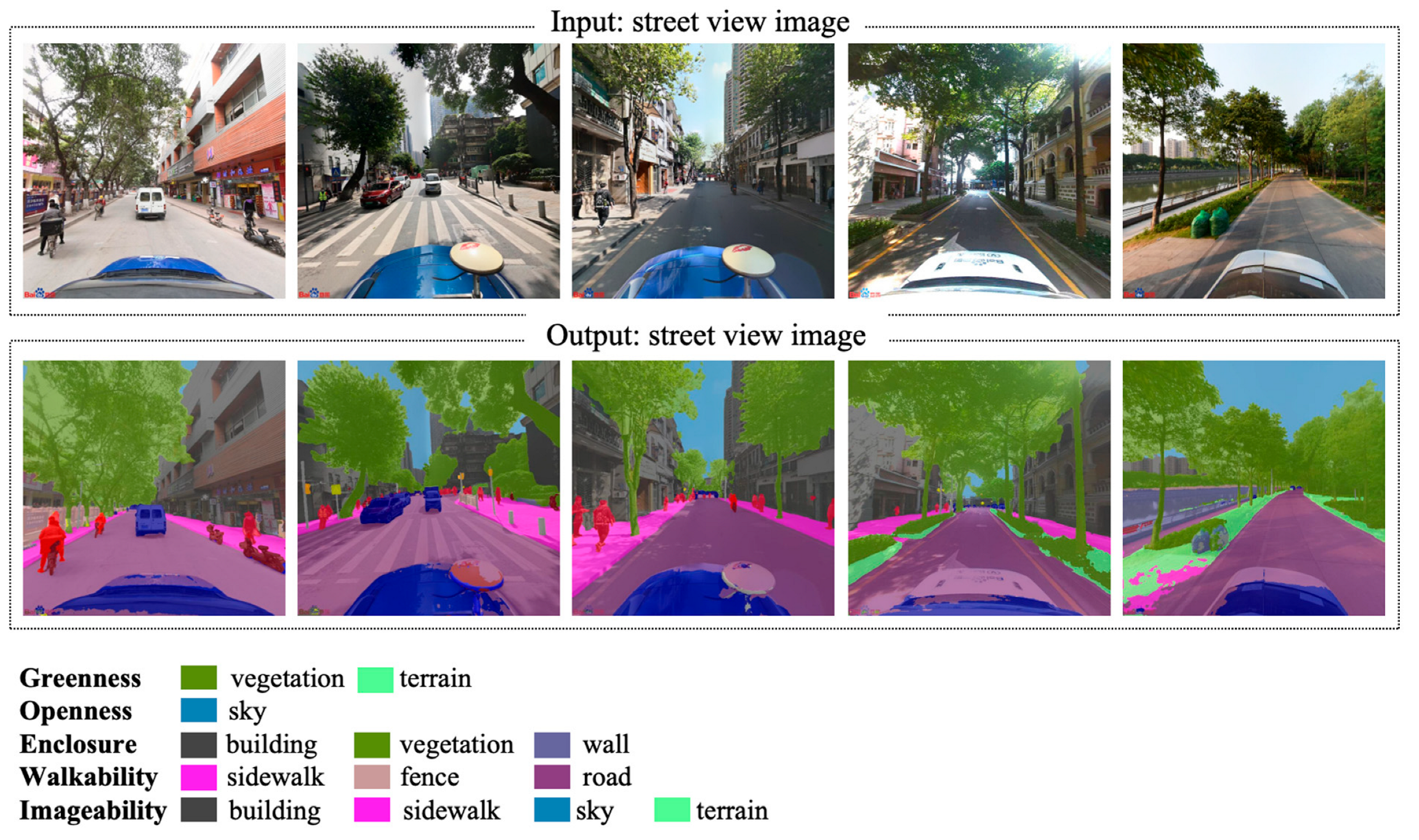
We employed Mask2Former model to extract semantic-level visual features from the collected SVIs. Mask2Former is a transformer-based semantic segmentation framework that provides multi-scale, high-resolution pixel-level classification. Its robustness in handling complex urban scenes made it particularly suitable for perceptual modeling at the city scale. The model used in this study was pre-trained on the publicly available Cityscapes dataset. The Cityscapes dataset is a widely adopted benchmark for urban scene understanding and autonomous driving research [26]. The dataset includes 5000 finely annotated images with pixel-level semantic labels and 20,000 coarsely labeled images, covering 19 semantic categories such as road, building, vegetation, sidewalk, sky, vehicle, pedestrian, terrain, wall, fence and pole (https://github.com/mcordts/cityscapesScripts, accessed on 20 May 2025). Its detailed annotations and urban context provide strong generalizability for evaluating semantic segmentation models in real-world street environments.
In total, 6064 directional SVIs (1516 locations × 4 directions) were processed using the Mask2Former model to generate semantic segmentation masks. For each image, the proportion of pixels belonging to each of the 19 semantic categories was computed and stored in a structured dataset. These pixel proportions serve as the semantic input variables for subsequent modeling of perceived restorativeness.
Following segmentation, all semantic-label data were imported into QGIS for spatial aggregation. Specifically, the semantic ratios from the four directional images at each location were averaged to obtain a single aggregated semantic feature vector per sampling point. The aggregated values were then sorted and analyzed to identify dominant semantic components across the study area.

2.3.3. Visual Feature Derivation

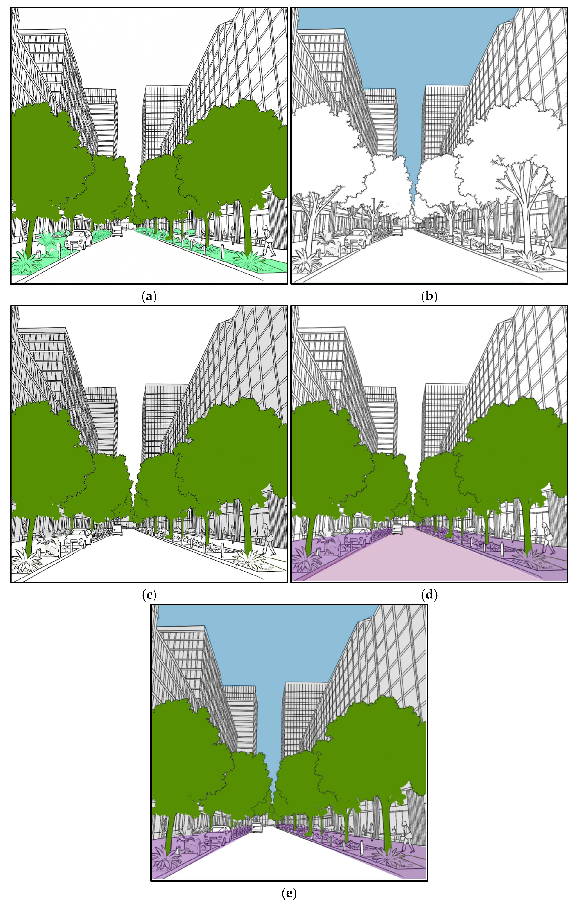
To quantitatively assess the perceived restorativeness of urban streetscapes, this study adopted a visual indicator system based on semantic segmentation of Baidu Street View Images (BSVIs). The system included five key visual metrics, namely greenness, openness, enclosure, walkability, and imageability, computed from eight semantic classes in the BSVIs (road, buildings, vegetation, sky, sidewalks, fence, wall, terrain), which were derived from pixel-level semantic elements to capture key visual features from a pedestrian perspective (Figure 5 and Figure 6). These indicators have been empirically validated in previous studies as being closely associated with restorative perception [1,2,3,4]. Definitions and illustrative examples of the indicators are provided in Table 1. These metrics were subsequently used as objective predictors of the PRS dimensions in the correlation and regression analyses.
(1)
Greenness
Urban greenspace is widely recognized as a key factor in promoting psychological restoration. It enhances the visual comfort of street environments, helps alleviate stress, and encourages longer durations of outdoor activity. According to Attention Restoration Theory [6], natural elements such as trees and grass facilitate recovery from mental fatigue through mechanisms such as soft fascination, being away, and environmental compatibility. Visible greenery in urban neighborhoods significantly enhances residents’ perceptions of environmental quality and restorative potential [11]. Streetscapes with greenery along sidewalks and building facades were consistently rated as more restorative [27,28]. The highest-scoring model featured continuous rows of street trees and open front yards [28].
(2)
Openness
Openness is derived from the pixel proportion of the sky class, indicating the degree of vertical spatial openness and unobstructed visual access [29]. Higher openness typically correlates with a stronger sense of freedom and reduced spatial stress [4,30]. While it may foster relaxation and mental ease, excessive openness without enclosure may also reduce perceived safety or hinder social interaction, highlighting the importance of balanced spatial design [31].
(3)
Enclosure
Enclosure is measured by the pixel proportion of the building class, representing the perceived degree of spatial containment. While a moderate level of enclosure can create a sense of order and human scale, excessive enclosure tends to intensify perceived crowding and visual oppression [32]. It has been linked to lower levels of psychological comfort and increased stress, serving as a critical negative predictor in restorative perception analysis.
(4)
Walkability
Walkability is calculated based on the proportion of sidewalk pixels, indicating the presence and quality of pedestrian infrastructure. A higher walkability score suggests improved pedestrian accessibility and mobility, which has been associated with enhanced safety, social interaction, and overall restorative perception [33]. It also serves as a proxy for physical and psychological comfort in urban public space.
(5)
Imageability
Imageability, originally conceptualized by Lynch [34], refers to the quality of a physical environment that makes it recognizable, distinctive, and memorable. In the context of urban streetscapes, imageability arises from the presence of coherent, diverse, and legible visual features, which help individuals to mentally structure their surroundings. According to environmental psychology, highly imageable environments can foster a sense of orientation, place identity, and cognitive engagement, thereby supporting psychological restoration [35].

2.4. Perceptual Annotation and Scoring

To assess the perceived restorativeness of urban streetscapes, this study developed an online questionnaire based on the classic Perceived restorativeness scale (PRS). The questionnaire drew on extended versions of the PRS and Perceived Restorative Soundscape Scale (PRSS), focusing specifically on visual perception and encompassing four core dimensions: Fascination, Being Away, Compatibility, and Coherence [36]. Each dimension was evaluated using a single statement rated on a five-point Likert scale (1 = strongly disagree, 5 = strongly agree). The resulting scores were used as the dependent variable in subsequent regression analysis (Table 2). The study was conducted in accordance with the Declaration of Helsinki, and the protocol was approved by Ethics Committee of the Faculty of Innovation and Design, City University of Macau (reference number: 202507281356) on 31 July 2025.
To ensure the representativeness and quality of the survey data, the formal questionnaire was distributed via Wenjuanxing platform (https://www.wjx.cn/, accessed on 20 May 2025), a major Chinese online survey tool. Prior to formal distribution, a pilot test was conducted with 10 volunteers to optimize the questionnaire interface and instructional clarity. To improve data validity, quality control procedures were applied to remove invalid responses, such as those with viewing times less than 15 s per image or uniform ratings across all images. The typical time required to complete the questionnaire ranged from 5 to 15 min.
A total of 200 street-view images were randomly presented in the survey. To reduce rating fatigue and minimize subjective bias, each participant was randomly assigned a subset of no more than 20 images and independently evaluated them across the four perceptual dimensions. A stratified sampling strategy was adopted to recruit urban residents, ensuring demographic diversity in terms of age (18–65 years), urban living experience, and educational background. After data cleaning, a total of 265 valid response sets were retained for subsequent modeling. We compared PRS scores between professionals and non-professionals using Welch’s t-tests and reported Hedges’ g with 95% confidence intervals.

2.5. Restorative Perception Prediction and Mapping

2.5.1. Machine Learning Modeling

To model the relationship between visual spatial features and restorative perception, a supervised machine learning model was developed using the Random Forest Regressor. The input features included the proportional coverage of the first eight semantic categories extracted from SVIs via semantic segmentation: road, building, vegetation, sky, sidewalk, fence, wall and terrain. These features reflect the physical and visual composition of each streetscape scene.
The target variables consisted of four perceptual scores, Fascination (F), Being Away (B), Compatibility (C), and Extent (E) which were obtained from the perception survey. Separate regression models were trained for each dimension to ensure specificity and interpretability.
The dataset was split into training and testing subsets using a ratio of 70 to 30. For each perceptual dimension, the corresponding model was trained on the training subset and evaluated on the test subset. The Random Forest algorithm was selected for its robustness, ability to handle nonlinear relationships, and effectiveness in capturing complex interactions between multiple visual features. Model performance was evaluated using R2 (coefficient of determination) and mean squared error (MSE).

2.5.2. Predictive Scoring and Classification

The trained random forest models were applied to all semantically segmented street-view images across the study area to predict restorative perception scores in four dimensions: Fascination, Being Away, Coherence, and Compatibility.
To further classify the levels of restorative perception, this study employed K-means clustering based on the predicted scores. This unsupervised approach automatically identified clusters of streetscapes with similar perceptual characteristics, enabling the extraction of spatial differences in restorative perception and the identification of zones with high, medium, and low restorative potential. For each sampling point, four directional SVIs were aggregated to obtain a point-level predicted restorative score, and K-means was applied to these point-level scores rather than to entire streets. The results provide a theoretical basis for subsequent spatial pattern analysis and urban renewal intervention strategies.
The optimal number of clusters (k) was determined using the elbow method. The within-cluster sum of squares declined rapidly when k increased from 1 to 3, indicating a substantial gain in clustering compactness. However, the rate of decline diminished significantly beyond k = 3, and the curve began to flatten, suggesting reduced marginal benefits from adding more clusters. Based on this inflection point, k = 3 was selected as the optimal solution. This choice not only achieves a balance between model simplicity and classification performance but also reflects the practical interpretability of restorative perception categories, which are typically classified as low, medium, and high in environmental psychology and spatial perception studies.

3. Results

3.1. Verification of the Reliability of Questionnaire Data

A total of 263 valid responses were obtained for the questionnaire. The questionnaire passed reliability and validity tests, with a Cronbach’s alpha of 0.995 and supporting indicators provided in Appendix A (Table A1). As shown in Table 3, the gender distribution was relatively balanced, with 125 participants identified as male, accounting for 47.5%, and 138 identified as female, representing 52.5%. In terms of age, 123 participants, or 46.8%, were aged between 18 and 25, followed by 65 participants aged 31 to 40, accounting for 24.7%. Additionally, 164 participants, equivalent to 62.4% of the sample, reported working in architecture, urban planning, or related fields. This reflects a high level of professional familiarity with streetscape environments and contributes to the credibility of perceptual assessments.
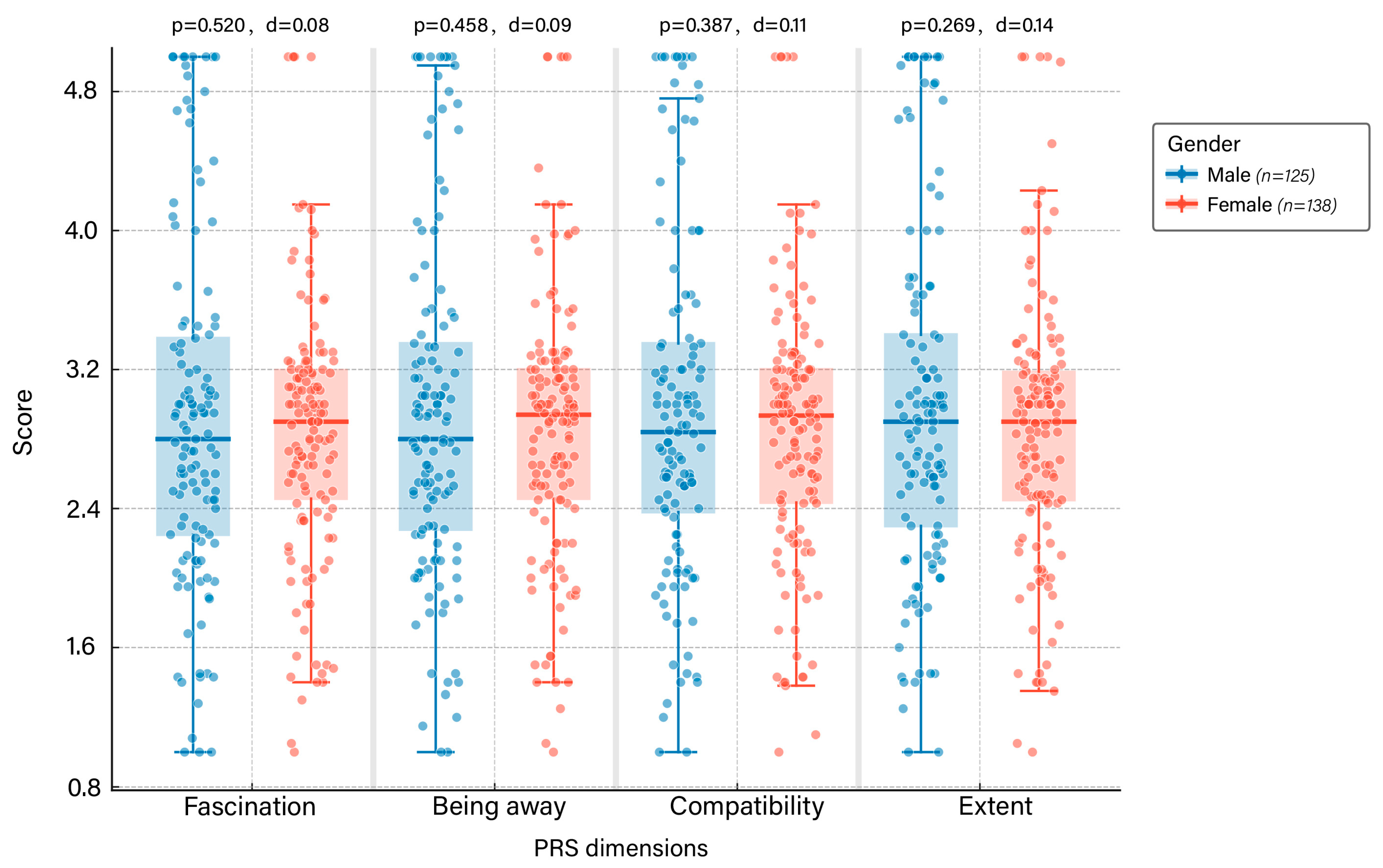
We compared males (n = 125) and females (n = 138) across the four PRS dimensions using Welch’s t-tests and reported effect sizes. Descriptively, males showed slightly higher means in all dimensions, with mean differences on the 1–5 scale ranging from 0.07 to 0.12. Variability was also somewhat larger among males (typical SD ≈ 1.0 vs. ≈ 0.77 in females). Inferentially, none of the gender contrasts reached significance (all p ≥ 0.269; |d| ≤ 0.14), and the 95% CIs of the mean differences encompassed zero for every dimension. Together, the direction of effects is consistent but very small in magnitude (Figure 7).
We then contrasted respondents working in a relevant industry (n = 164) with non-professionals (n = 99). Professionals reported slightly lower scores across all PRS dimensions, yielding small effects (Hedges’ g ≈ −0.22 to −0.27); group differences were statistically significant for Fascination, Being away, and Compatibility, but not for Extent. These effects are minor in magnitude and do not alter the overall pattern of perceived restorativeness (Table A2).

3.2. Performance Evaluation of Random Forest Model

Visual spatial indicators were regressed on perceived restorativeness dimensions (Table 4). The model fit for each regression is adequate, with R2 values ranging from 0.442 to 0.544, indicating that 44.2% to 54.4% of the variance in perceived restorativeness dimensions can be explained by the visual indicators. All models yield highly significant F-values (p = 0.000), confirming the overall statistical validity of the regression equations.
For the Fascination dimension, the regression model explained 44.2% of the variance (R2 = 0.442), with a significant overall model fit (F (5, 1516) = 239.181, p < 0.001). Among the predictors, Greenness showed a strong positive influence (t = 13.391, p < 0.001), while Openness (t = −8.829, p < 0.001) and Enclosure (t = −6.140, p < 0.001) had significant negative effects. Walkability also showed a marginally significant positive effect (t = 2.091, p = 0.037), and Imageability was positively associated (t = 4.526, p < 0.001).
For the Being Away dimension, the explanatory power was slightly higher (R2 = 0.537), with an F-value of 349.867 (p < 0.001). Greenness again emerged as the most significant predictor (t = 16.923, p < 0.001), while Openness (t = −9.801), Enclosure (t = −6.711), and Imageability (t = 4.730) were all statistically significant (p < 0.001). Walkability had a marginally significant effect (t = 2.063, p = 0.039).
In the Compatibility model, the R2 reached 0.533, and the model fit was statistically significant (F = 344.355, p < 0.001). Greenness continued to show a dominant role (t = 18.562, p < 0.001). Openness (t = −9.230) and Enclosure (t = −6.750) were significantly negative, while Imageability maintained a positive and significant association (t = 4.188). Walkability, however, was not statistically significant in this dimension (p = 0.415).
The model for Extent had the highest R2 at 0.544, with a significant F-value (F = 360.174, p < 0.001). Greenness again showed the strongest positive effect (t = 18.126, p < 0.001). Openness (t = −10.168) and Enclosure (t = −7.166) were both negatively associated, and Imageability remained significant (t = 4.675, p < 0.001). Walkability showed no significant effect (p = 0.213).
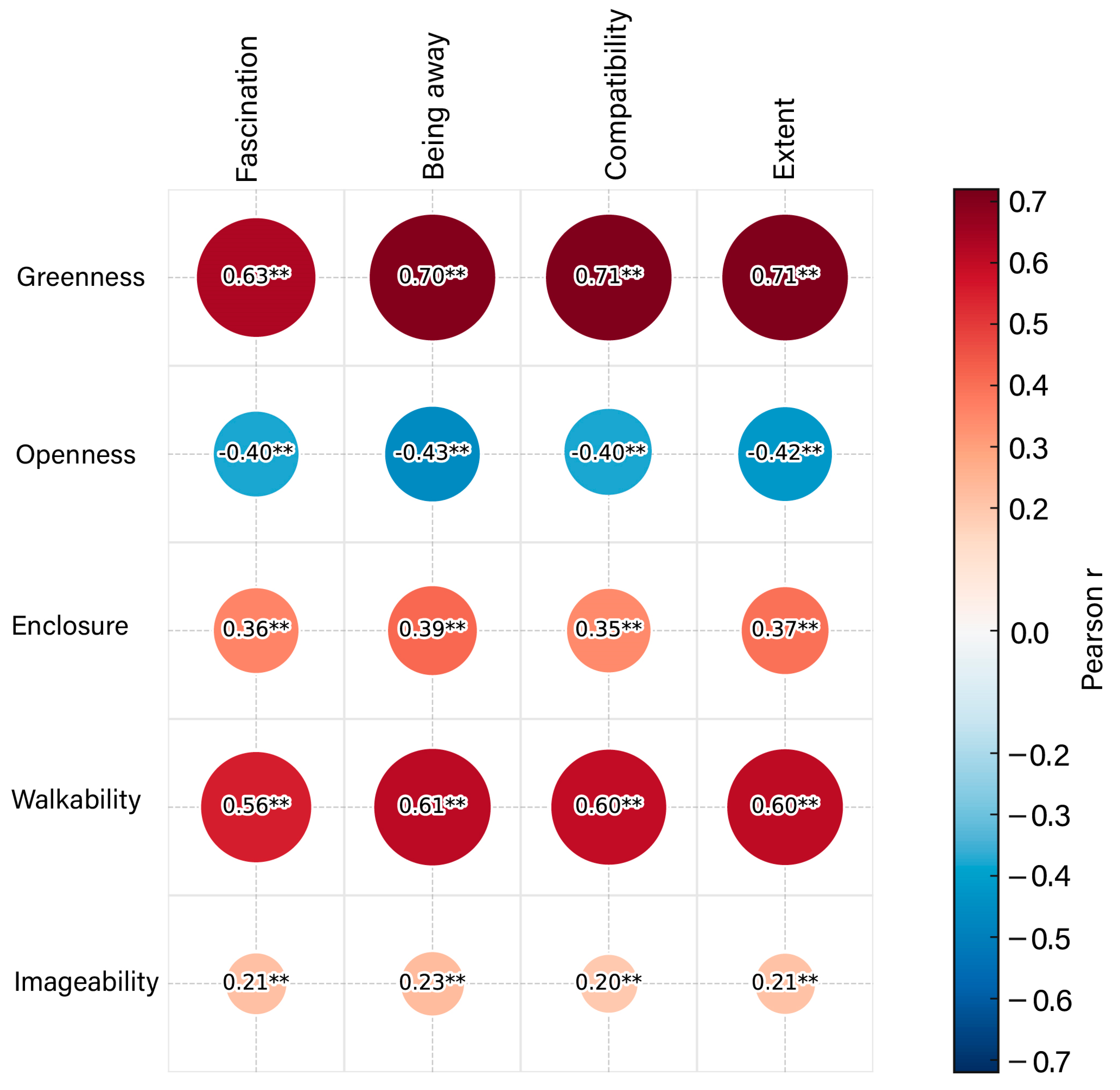
The regression results (Table 4) suggested that among the five key visual metrics, greenness consistently emerges as the strongest positive predictor of all four dimensions of perceived restorativeness. Openness and enclosure exert negative effects across dimensions, whereas imageability contributes moderately but consistently positively. Walkability demonstrated a limited and dimension-specific influence. Overall, the models demonstrated acceptable explanatory power (R2 = 0.44–0.54), supporting the relevance of visual spatial structure in shaping residents’ restorative experiences. To explore the associations between spatial visual features and perceived restorativeness, Pearson correlation analysis was conducted between five key visual metrics and the four PRS dimensions: Fascination, Being Away, Compatibility, and Extent. The pairwise associations display a clear pattern, greenness shows the strongest positive correlations, openness shows consistent negative correlations, enclosure and walkability show moderate positive correlations, and imageability shows weaker positive correlations (Figure 8, Table A3). The results demonstrated that all indicators were significantly correlated with at least one dimension of restorativeness (p < 0.01). Greenness consistently showed strong positive correlations with all four dimensions (r = 0.632–0.708), indicating its fundamental role in shaping restorative visual environments. Walkability also exhibited moderate-to-strong positive associations (r = 0.555–0.612), suggesting that the presence of sidewalks and fence elements relative to roads contributes meaningfully to perceived restoration. Enclosure, representing visual containment by buildings and trees, showed moderate positive correlations across all dimensions (r = 0.34–0.38). In contrast, Openness displayed significant negative correlations, implying that excessive spatial exposure might reduce the sense of refuge and thus restoration. Finally, Imageability showed weak but statistically significant positive correlations, indicating a complementary yet less dominant effect. These findings suggest that visual attributes such as greenery and walkability play critical roles in shaping restorative street-level experiences.

3.3. Restorative Perception Predicts Spatial Distribution

Among the 19 semantic categories, the ‘car’ label (occupying approximately 6% of total pixel ratio) was excluded from subsequent analysis due to its high spatial and temporal variability and its weak interpretability in relation to street environmental quality. Since parked or moving vehicles exhibit considerable randomness in street-view imagery, they may introduce noise rather than provide stable environmental cues. Instead, the ‘terrain’ category (with a lower presence of ~1%) was retained as a replacement. Despite its limited proportion, terrain features such as bare ground or open earth surfaces are more directly associated with perceptual metrics such as openness and enclosure, therefore contributing more meaningfully to the restorative perception modeling. The resulting semantic composition, ranked by average area proportion, is as follows: Road > Buildings > Vegetation > Sky > Sidewalks > Fence > Wall > Terrain. Detailed data can be found in Table 5.
Table 5 presents the descriptive statistics of visual elements extracted through semantic segmentation of BSVIs, as well as the derived perceptual indicators. Among the basic visual components, roads (M = 0.248), buildings (M = 0.199), and vegetation (M = 0.195) accounted for the highest average proportions, indicating their dominance in the streetscape composition. Meanwhile, sidewalks, fences, and terrain appeared in relatively lower proportions, suggesting limited pedestrian-specific infrastructure in the visual field.
For the derived perceptual indices, Enclosure (M = 0.416, SD = 0.155) and Imageability (M = 0.606, SD = 0.074) exhibited the highest means, reflecting strong spatial legibility and enclosure across the sample. Greenness and Openness showed moderate levels with notable variation, while Walkability had the largest standard deviation (SD = 0.296) and extreme maximum (Max = 3.500), indicating potential skewness or outliers that warrant further investigation.
The spatial distribution of the five visual metrics—greenness, openness, enclosure, walkability, and imageability—demonstrates evident heterogeneity across Liwan District (Figure 9). In all maps, darker colors indicate higher values, while lighter shades represent lower scores for each visual attribute. High levels of greenness and enclosure were predominantly observed in the northern and central parts, particularly in historical neighborhoods with dense vegetation and traditional street structures. In contrast, the southern zones showed lighter colors, indicating reduced ecological and spatial coherence.
Openness and imageability exhibited more fragmented patterns, with pockets of high values scattered across major road intersections and commercial clusters. Walkability scores were relatively higher in the northeast and southwest subregions, corresponding to better-maintained pedestrian infrastructure. These spatial variations in visual indicators laid the foundation for perceptual modeling in the next section, highlighting areas with potentially higher restorative affordances.
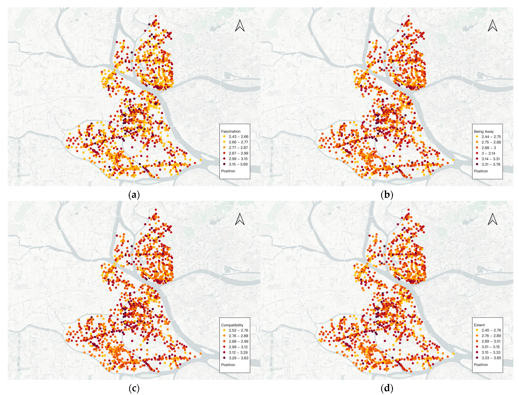
The four restorative perception dimensions proposed by Attention Restoration Theory (ART) have been widely applied to assess the restorative characteristics of environments [20,34,35]. Building upon this theoretical framework, the present study integrated semantic features extracted from street-view imagery with machine learning models to predict and map the spatial distribution of these four dimensions across the Liwan District of Guangzhou (Figure 10).
High values of Fascination were mainly concentrated in the northern and southeastern areas, which were characterized by abundant greenery, layered street interfaces, and visually appealing elements. These areas typically featured high levels of landscape diversity and visual detail, which stimulated users’ attention and interest, indicating a strong level of sensory engagement.
Being Away showed noticeable clustering in the southwestern and peripheral parts of the district. These areas tended to be farther from major roads, experience less traffic disturbance, and offer quieter, more enclosed environments. Such conditions were conducive to creating a psychological sense of escape from daily routines, providing perceptual relief and detachment. High scores of Compatibility were mostly distributed in the central and southern regions, often associated with walkable environments, coherent spatial layouts, and appropriately scaled street interfaces. These areas usually provide convenient pedestrian access and functional consistency, allowing individuals to align their behaviors with the environment and enhancing the sense of environmental fit.
Overall, while some overlap exists among the four dimensions, each also demonstrates unique clustering patterns. These results suggested that different semantic features of urban streetscapes influence specific aspects of restorative perception in varied ways.

3.4. Perception Clustering Partition Analysis

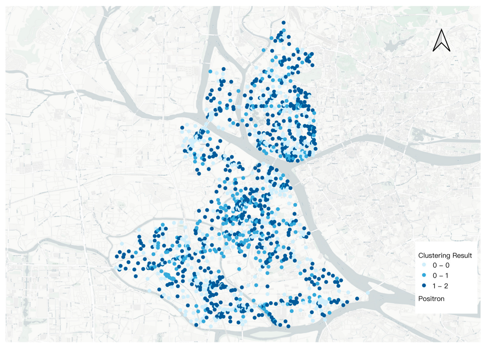
Based on the K-means clustering algorithm, the street-view images were categorized into three distinct clusters according to their predicted restorative scores (Figure 11). The spatial clustering results based on K-means algorithm reveal clear patterns in the geographic distribution of restorative perceptions (Figure 12). This clustering was derived from the outputs of a random forest regression model trained on a subset of manually rated images, and it reflects systematic differences in perceptual qualities across the dataset.
Specifically, clusters with high predicted restorative scores were predominantly located in the northern and central parts of Liwan District. These areas were known for their historical street texture, high walkability, and enclosed visual features, which likely contribute to their stronger restorative affordances.
Clusters with medium-level perception scores were more widely distributed in transitional zones between historical core areas and modern developments. These environments might contain a mixture of visual elements that provide moderate restorative potential without standing out as either highly beneficial or severely lacking.
On the other hand, low restorative perception clusters were mostly found along the periphery of the district and near industrial facilities or major traffic corridors. The built environment in these zones tends to lack greenness, visual coherence, and walkability, resulting in diminished perceptual quality.
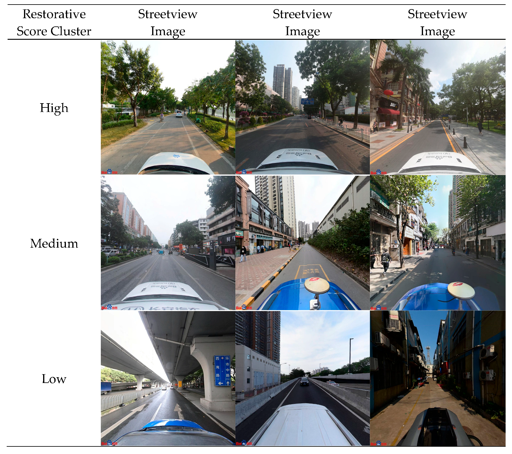
Figure 11 presents representative images and their semantic segmentation results from the three types of streetscapes identified through K-means clustering based on restorative perception scores. The high-score cluster typically features streets with abundant greenery, wide sidewalks, and continuous spatial facades. The medium-score cluster reflected transitional urban spaces with less vegetation and more mixed visual elements. The low-score cluster was dominated by hard infrastructure, limited greenery, and poorly defined spatial boundaries. The typical image of a high score presents a walking-friendly scene with ample greenery and continuous sidewalks, while the typical image of a low score presents a completely walking-unfriendly scene with almost no greenery, only roadways, and no sidewalks. These image samples intuitively validated the effectiveness of the clustering results and help interpret perceptual differences across street types. The observed within street heterogeneity indicates that subtle changes in greenness, continuity of the street edge enclosure such as fences or vegetated buffers, and continuity of pedestrian activity can shift adjacent segments of the same street into different clusters. Given the practical difficulty of upgrading an entire corridor, we recommend prioritizing segments with low scores for intervention, for example, by expanding shade, completing street edge elements, and improving sidewalk continuity to enhance walkability.
These findings showed that restorative perception exhibits a distinct spatial logic aligned with urban morphological structure and street typology. This pattern reinforced the value of using data-driven clustering techniques to identify spatial inequalities in psychological affordance, which could inform targeted urban interventions and restorative-oriented street renewal strategies.

4. Discussion

4.1. The Relationship Between Restorative Perception and the Characteristics of Street Space

Among the five visual metrics, greenness consistently emerged as the strongest positive predictor across all four dimensions of perceived restorativeness. This result is consistent with recent studies that emphasizes the essential role of natural elements in promoting psychological restoration [5,11], and it supports the core assumption of Attention Restoration Theory (ART), which posits that nature-rich environments help mitigate directed attention fatigue [17].
Notably, the predictive strength of greenness was particularly pronounced in the dimensions of Being Away and Fascination. This suggests that greenness not only contributes to general environmental preference but also plays a more targeted role in facilitating psychological detachment and sensory engagement. Greenery exerted a stronger influence on perceived restorativeness than on aesthetic preference, highlighting its role in fostering mental separation from everyday stressors [37]. Streets with continuous greenery and high green coverage within the visual field significantly enhanced scores in the Fascination dimension, a pattern that is echoed in the present study’s spatial prediction [38]. The richness and accessibility of green spaces are crucial for enhancing the overall quality of urban street spaces and the satisfaction of residents’ lives [22]. These findings suggest that greenness is not a monolithic contributor to restorative perception. Rather, it exerts differentiated psychological effects across multiple dimensions, depending on its spatial configuration and visual integration. From a design perspective, this implies that green interventions should not merely aim to increase vegetation quantity but should strategically enhance specific experiential qualities. Species diversity and seasonal color variation may better stimulate fascination [39,40], whereas linear green corridors or enclosed planting schemes may enhance the sense of being away [41,42].
Openness showed a negative correlation with perceived restorativeness across dimensions, suggesting that overly open or sparse streetscapes may reduce psychological comfort. This supports conclusions drawn by Abkar [43], who argued that environmental enclosure fosters a sense of safety and immersion. While openness is often valued in spatial design for its contribution to visibility, legibility, and accessibility, our results reveal a counterintuitive effect: in dense urban environments, a high degree of openness without the presence of soft boundaries, greenery, or active street interfaces may induce perceptual discomfort and undermine attentional restoration.
This finding is consistent with previous research in restorative environmental psychology, where uncontrolled exposure to traffic, noise, and visual clutter has been shown to suppress perceived restorativeness [44,45]. Moderate levels of enclosure have been identified as contributing to a greater sense of refuge and psychological safety, whereas fully open vistas may induce feelings of vulnerability or perceptual disengagement [30,31,45,46]. Our findings suggest that openness, when not buffered by enclosure or softened through vegetation, may fail to support the restorative affordances articulated by Attention Restoration Theory (ART), especially for the dimensions of Being Away and Compatibility.
Furthermore, the negative coefficients of openness persisted even when greenness and walkability were controlled for in regression models. This indicates that openness is not merely a proxy for lack of greenery or low walkability, but an independent spatial cue that may disrupt the perceptual structure required for restorative engagement. In this sense, openness interacts negatively with other visual semantics by amplifying exposure and diminishing spatial legibility, particularly in environments that lack design continuity or human-scale features.
From a design perspective, this suggests that maximizing openness should not be a default objective in streetscape enhancement. Instead, psychological comfort may be better supported by carefully balanced openness that is framed by tree canopies, façade continuity, or vertical planting. Future interventions should distinguish between functional openness and perceptual openness, which can have unintended cognitive effects if not properly mitigated.
We found that walkability exhibited relatively weak and heterogeneous predictive power across the four dimensions of perceived restorativeness. It showed marginally significant positive associations with fascination and being away (p < 0.05), while demonstrating no significant effects on compatibility and extent, which are more dependent on spatial structure and behavioral congruence. These findings indicate that the restorative dimensions respond differently to spatial characteristics, and that the physical accessibility represented by walkability may be insufficient to capture psychological needs related to cognitive engagement and structural perception.
However, our clustering results present an interesting contrast. The high-restorativeness image clusters—identified through unsupervised learning—frequently featured walking-friendly streetscapes characterized by continuous shade, wide sidewalks, and human-scale enclosures. Conversely, low-scoring images often lacked pedestrian infrastructure and spatial coherence. This suggests that although walkability, when treated as an isolated visual metric, may not strongly predict all dimensions of restoration, it nevertheless plays an important role in shaping the holistic impression of a restorative environment.
This discrepancy underscores the need to understand walkability not merely as a functional attribute, but as an embodied perceptual experience. When individuals judge whether a streetscape feels restorative, they may be implicitly imagining themselves walking through it, integrating structural, visual, and experiential cues. Therefore, a more comprehensive approach should consider walkability as an emergent property embedded in the interplay of multiple elements—such as enclosure, greenery, imageability, and visual complexity—rather than evaluating it in isolation.
In existing research, complexity has been identified as a critical factor influencing restorative perception [47]. This includes variations in material texture, façade detail, color contrast, vertical rhythm, and other forms of visual richness [48]. In contrast, traditional measures of walkability emphasize structural continuity but often overlook such restorative cues. As such, incorporating walkability into perceptual models requires not only structural metrics, but also semantic and affective layers of interpretation. In the context of restorative street design, walkability should serve as a foundational but integrative concept, bridging physical accessibility and psychological affordance, and enhancing the explanatory power of perception-oriented predictive models.
Given this, walkability should be understood as a composite variable encompassing both structural accessibility and perceptual qualities, rather than a standalone functional metric. In multidimensional frameworks, it should be modeled in conjunction with enclosure, imageability, human scale, greenness, and spatial concealment [49]. Previous studies have also emphasized that restorative perception emerges from the joint activation of multiple semantic elements, rather than being driven by a single spatial property [2]. Therefore, in the context of restorative street design, walkability should serve as a foundational structural indicator integrated with semantic visual features, thereby improving the explanatory power of predictive models and supporting health-oriented urban regeneration practices.
We further examined whether gender influences the four PRS dimensions. Across all dimensions, the differences between male and female were not statistically significant and were negligible in magnitude, indicating that perceived streetscape restorativeness is essentially comparable across genders. These results strengthen the generalizability of the study and support the applicability of evidence based urban design strategies to the wider population, including increasing greenery, calibrating enclosure to appropriate levels, and improving spatial coherence.
We also examined differences by professional affiliation. Although professionals tended to rate streetscapes slightly lower than non-professionals, the effects were uniformly small, and the overall association patterns remained consistent across groups. This suggests that our conclusions are broadly generalizable to the wider resident population; nonetheless, the unequal subgroup sizes (164 vs. 99) should be noted as a limitation and warrant confirmation in stratified, adequately powered follow ups.

4.2. Method Advantages

This study presents significant methodological advantages over traditional environmental psychology surveys. By integrating semantic segmentation and machine learning techniques, it enables large-scale, automated prediction of perceived restorativeness, overcoming limitations of manual questionnaires in terms of time, labor, and spatial coverage. Traditional subjective surveys, while foundational to environmental perception studies, often suffer from limited spatial coverage, sampling bias, and high labor costs [20,50,51]. For example, questionnaires distributed via social media platforms tend to attract younger, urban-dwelling participants, thereby reducing representativeness [20]. Similarly, field-based surveys are constrained by small sample sizes and inefficiency, making them difficult to scale across large urban areas [49].
To overcome the spatial and operational constraints of traditional survey-based approaches in environmental psychology, this study adopts a methodological framework based on semantic segmentation and machine learning. Unlike conventional methods that rely heavily on small-scale field surveys or subjective image annotation, the proposed approach enables large-scale, fine-grained assessment of perceived restorativeness across urban streetscapes. Semantic segmentation facilitates the automated extraction of pixel-level visual features from street-view imagery, while the machine learning model establishes a predictive mapping between these features and human perceptual responses. This combination not only enhances modeling efficiency and reproducibility but also improves scalability and transferability across urban contexts. Moreover, by incorporating perception-based clustering and spatial visualization, the framework offers an interpretable means to identify street-level patterns of restorativeness, thus supporting evidence-based interventions for restorative urban design.
Compared with these studies, this research demonstrates methodological innovation in four key aspects. First, the target environment of urban streetscapes is more complex and dynamic than park or satellite-based landscapes, involving dense semantic features and frequent visual disruptions. Second, this study is grounded in Attention Restoration Theory (ART) and models four psychological dimensions of restorativeness including fascination, being away, compatibility, and extent. This bridges computational modeling with theoretical constructs in environmental psychology. Third, the study employs five semantically visual metrics including greenness, openness, enclosure, walkability, and imageability, all extracted from panoramic BSVIs using semantic segmentation. This ensures replicability, spatial precision, and psychological relevance. Finally, the analysis is conducted at the street-point level, offering finer spatial resolution and practical value for urban design compared to assessments at the neighborhood or block scale.
Our contribution extends beyond object segmentation by establishing an interpretable measurement chain that links eight semantic classes to five theory-guided indicators and, in turn, to four PRS dimensions. By aggregating predictions at sampling points and operating at the street-segment scale, the framework supports precise targeting and prioritization in practice. This improves interpretability for design decisions on greenery, enclosure and walkability, and facilitates reproducible deployment across different urban areas. Collectively, this approach extends the application of deep learning and semantic segmentation from static green spaces to everyday street environments and enriches both theoretical modeling and decision-making tools for health-oriented urban planning.

4.3. Enhancing Urban Renewal: Psychological Insights for Street Revitalization in Liwan District

Situated in the core of Guangzhou’s historic city, Liwan District is undergoing intensive urban renewal guided by the municipal strategy of upgrading old neighborhoods, low-efficiency parcels, and traditional marketplaces. The district promotes micro-regeneration models that emphasize spatial quality enhancement, historical memory preservation, and health-supportive public space design. In this context, the current study applies semantic segmentation and machine learning to SVIs to identify spatial patterns of perceived restorativeness at the street-point level, offering a psychological layer for prioritizing interventions in street revitalization.
Cluster results indicate that high-restorativeness areas are mainly located along Zhongshan Seventh Road and the historic Xiguan district, particularly in streets such as Enning Road, Yongqingfang, and Baohua Road. These zones have undergone pedestrian-friendly redesign, interface activation, greening, and cultural reprogramming as part of Guangzhou’s incremental “embroidered-style” regeneration strategy. These design efforts have significantly improved visual experience and are reflected in high predicted values of Fascination and Compatibility dimensions in our model. This is consistent with other street-level studies that confirm human-scale design and cultural vibrancy as key factors in enhancing visual and psychological appeal [52,53].
Conversely, low-restorativeness clusters are concentrated in areas such as the southern segment of Zhongnan Street, the Fangcun–Nan’an Road junction, and several urban villages west of Longjin Middle Road, including Xicun, Chongkou, and Hedong. These streets are often narrow, visually enclosed, and lack greenery, resulting in diminished perceived immersion and coherence. Prior research on greenery distribution across Guangzhou shows that many of these areas exhibit lower green view index, particularly in Fengyuan, which correlates with poor visual accessibility and limited restoration potential. Some of these low-performing zones, such as the Hedong–Shiwutang area, have already been included in Liwan’s official urban renewal inventory, confirming the practical utility of our model in preemptively identifying areas of low psychological affordance.
This study presents a data-driven, psychologically grounded framework for identifying street segments with varying restorative potentials, enabling precise spatial diagnostics in support of Guangzhou’s stock-based urban regeneration. By integrating perceived restorativeness with semantic visual indicators, the model supports finer-scale, human-centered intervention strategies that are especially relevant in dense historical environments where design sensitivity and cultural context are critical.

4.4. Limitations and Improvement Directions

While this study presents a novel framework for modeling perceived restorativeness of urban streetscapes, several limitations remain. First, although the questionnaire survey followed a controlled and stratified sampling procedure, subjective bias may still exist in participants’ evaluations due to personal experiences, cognitive preferences, or contextual differences. Additionally, to reduce respondent burden, each participant only rated a limited number of SVIs, which may have affected the overall data distribution and weakened the representativeness of certain images in the training sample.
Second, due to practical constraints, the semantic segmentation and machine learning model were limited to visual information extracted from SVIs. This overlooks other potentially influential sensory dimensions, such as soundscapes, airflow, and microclimate. Incorporating multimodal data in future studies, such as ambient noise, air quality, or perceived temperature may enhance the comprehensiveness and ecological validity of the prediction model.
Third, in the image-based prediction framework, we aggregated four directional images to represent a single street-view location. However, perceptual differences among directions may cause inconsistency in labeling, potentially affecting the clustering and classification accuracy. Future studies could explore image fusion methods or introduce spatial continuity constraints to enhance prediction consistency across views.
Overall, while the current approach improves efficiency and spatial granularity in measuring urban perception, its performance may benefit from more diverse data inputs, improved labeling strategies, and integrated modeling techniques. Beyond mapping and correlational analysis, the framework can inform subsequent phases of planning and management. It can prioritize the conservation of segments that consistently achieve high restorative scores, identify low-scoring segments for targeted renewal, and enable lightweight monitoring through periodic re-scoring. Future research could further develop cross-city transferable models or integrate real-time perception sensing methods to support adaptive urban design and policy interventions.

5. Conclusions

This study presents a data-driven framework for modeling and mapping perceived restorativeness in urban streetscapes by integrating semantic segmentation, visual indicators, and machine learning. Using 1516 Baidu street-view image locations in Guangzhou’s Liwan District, we predicted perceived restorativeness across four dimensions (Fascination, Being Away, Coherence, and Compatibility) based on Random Forest regressors trained on PRS questionnaire data. The model is then used to predict restorativeness scores across all images. Spatial clustering and regression analysis were conducted to reveal spatial patterns and variations in perceived restorativeness. The models achieved moderate predictive performance and revealed strong associations between semantic features, especially greenness and enclosure, and perceived restorativeness.
Furthermore, K-means clustering of predicted scores identified spatial groupings of high-, medium-, and low-restorativeness areas, offering insights into localized design and renewal strategies. High-score clusters often corresponded to traditional blocks with vegetation and coherent facades, while low-score areas were typically associated with fragmented and open arterial roads. These findings suggest that restorative urban design can be quantitatively guided using data-driven methods.
This study bridges subjective psychological perception with objective spatial features through scalable computational methods. Looking ahead, the pipeline can be extended from identification and analysis to conservation and protection workflows by safeguarding high value segments, tracking temporal change, and stress testing design alternatives. This provides a repeatable evidence base for restorative and equitable street segment renewal. It contributes both methodological innovations and empirical findings to the growing field of perceptual urban analytics, lays a foundation for future cross-city studies and human-centered planning applications.

Author Contributions

Conceptualization, W.K., N.K. and P.W.; methodology, W.K., N.K. and P.W.; software, W.K.; validation, N.K.; formal analysis, N.K.; investigation, W.K. All authors have read and agreed to the published version of the manuscript.

Funding

This research received no external funding.

Data Availability Statement

The raw data supporting the conclusions of this article will be made available by the authors upon request.

Conflicts of Interest

The authors declare no conflicts of interest.

Appendix A

Table A1. Results of questionnaire reliability and validity analysis.
CaseValid263Cronbach’s alpha0.995
Exclued0Bartlett’s test
of sphericity
Approx Chi-Square95628.36
Total263df11,476
KMO of sampling adequacy0.931Sig.0.000
Table A2. PRS scores: professionals vs. non-professionals.
PRS DimensionsProfessional (n = 164) Mean ± SDNon-Professional (n = 99) Mean ± SDMean Diff (Prof-Non)pCohen’s d (Hedges g)
Fascination2.80 ± 0.983.03 ± 0.70−0.230.03−0.26
Being away2.82 ± 0.973.04 ± 0.71−0.220.037−0.25
Compatibility2.82 ± 0.963.05 ± 0.71−0.230.025−0.26
Extent2.83 ± 0.973.03 ± 0.73−0.20.064−0.22
Table A3. Pearson correlation analysis of spatial features and PRS.
PRS
Dimensions
FascinationBeing AwayCompatibilityExtent
Visual
Metrics
Greenness0.632 **0.702 **0.707 **0.708 **
Openness−0.397 **−0.428 **−0.396 **−0.421 **
Enclosure0.356 **0.385 **0.348 **0.371 **
Walkability0.555 **0.612 **0.598 **0.605 **
Imageability0.214 **0.227 **0.196 **0.211 **
** p < 0.01.

References

  1. Liu, R.; Neisch, P. Measuring the Effectiveness of Street Renewal Design: Insights from Visual Preference Surveys, Deep-Learning Technology, and Eye-Tracking Simulation Software. Landsc. Urban Plann. 2025, 256, 105291. [Google Scholar] [CrossRef]
  2. Ma, X.; Ma, C.; Wu, C.; Xi, Y.; Yang, R.; Peng, N.; Zhang, C.; Ren, F. Measuring Human Perceptions of Streetscapes to Better Inform Urban Renewal: A Perspective of Scene Semantic Parsing. Cities 2021, 110, 103086. [Google Scholar] [CrossRef]
  3. Dai, L.; Zheng, C.; Dong, Z.; Yao, Y.; Wang, R.; Zhang, X.; Ren, S.; Zhang, J.; Song, X.; Guan, Q. Analyzing the Correlation between Visual Space and Residents’ Psychology in Wuhan, China Using Street-View Images and Deep-Learning Technique. City Environ. Interact. 2021, 11, 100069. [Google Scholar] [CrossRef]
  4. Tang, J.; Long, Y. Measuring Visual Quality of Street Space and Its Temporal Variation: Methodology and Its Application in the Hutong Area in Beijing. Landsc. Urban Plann. 2019, 191, 103436. [Google Scholar] [CrossRef]
  5. Zhao, J.; Wu, J.; Wang, H. Characteristics of Urban Streets in Relation to Perceived Restorativeness. J. Expo. Sci. Environ. Epidemiol. 2020, 30, 309–319. [Google Scholar] [CrossRef]
  6. Kaplan, R.; Kaplan, S. The Experience of Nature: A Psychological Perspective; Cambridge University Press: Cambridge, UK, 1989. [Google Scholar]
  7. Rezvanipour, S.; Hassan, N.; Ghaffarianhoseini, A.; Danaee, M. Why Does the Perception of Street Matter? A Dimensional Analysis of Multisensory Social and Physical Attributes Shaping the Perception of Streets. Archit. Sci. Rev. 2021, 64, 359–373. [Google Scholar] [CrossRef]
  8. Lindal, P.J.; Hartig, T. Effects of Urban Street Vegetation on Judgments of Restoration Likelihood. Urban For. Urban Green. 2015, 14, 200–209. [Google Scholar] [CrossRef]
  9. Barros, P.; Mehta, V.; Brindley, P.; Zandieh, R. The Restorative Potential of Commercial Streets. Landsc. Res. 2021, 46, 1017–1037. [Google Scholar] [CrossRef]
  10. Messier, L. Complete Streets Meet Fragmented Policies: Sidewalks in 30 U.S. Cities. Cities 2025, 157, 105588. [Google Scholar] [CrossRef]
  11. Sarkar, C.; Webster, C.; Pryor, M.; Tang, D.; Melbourne, S.; Zhang, X.; Jianzheng, L. Exploring Associations between Urban Green, Street Design and Walking: Results from the Greater London Boroughs. Landsc. Urban Plann. 2015, 143, 112–125. [Google Scholar] [CrossRef]
  12. Pérez, K.; Palència, L.; López, M.J.; León-Gómez, B.B.; Puig-Ribera, A.; Gómez-Gutiérrez, A.; Nieuwenhuijsen, M.; Carrasco-Turigas, G.; Borrell, C. Environmental and Health Effects of the Barcelona Superblocks. BMC Public Health 2025, 25, 634. [Google Scholar] [CrossRef]
  13. Ma, Q.; Wei, X.; Ren, G. Street Design Guidelines and Urban Road System Improvement: From Traffic Volume to Space Quality. Transp. Res. Procedia 2025, 82, 3266–3282. [Google Scholar] [CrossRef]
  14. Wu, K.; Guo, Y.; Han, X. The Relationship Research between Restorative Perception, Local Attachment and Environmental Responsible Behavior of Urban Park Recreationists. Heliyon 2024, 10, e35214. [Google Scholar] [CrossRef]
  15. Prince, M.; Patel, V.; Saxena, S.; Maj, M.; Maselko, J.; Phillips, M.R.; Rahman, A. No Health without Mental Health. Lancet 2007, 370, 859–877. [Google Scholar] [CrossRef]
  16. Li, Q. Effect of Forest Bathing Trips on Human Immune Function. Environ. Health Prev. Med. 2010, 15, 9–17. [Google Scholar] [CrossRef]
  17. Chen, S.; Chen, Z.; Hong, J.; Zhuang, X.; Su, C.; Ding, Z. Exploring the Relationship between Audio–Visual Perception in Fuzhou Universities and College Students’ Attention Restoration Quality Using Machine Learning. Front. Psychol. 2025, 16, 1572426. [Google Scholar] [CrossRef]
  18. Liu, Q.; Wu, Y.; Xiao, Y.; Fu, W.; Zhuo, Z.; Van Den Bosch, C.C.K.; Huang, Q.; Lan, S. More Meaningful, More Restorative? Linking Local Landscape Characteristics and Place Attachment to Restorative Perceptions of Urban Park Visitors. Landsc. Urban Plann. 2020, 197, 103763. [Google Scholar] [CrossRef]
  19. Kang, N.; Bell, S.; Ward Thompson, C.; Zheng, M.; Xu, Z.; Sun, Z. Use of Urban Residential Community Parks for Stress Management during the COVID-19 Lockdown Period in China. Front. Psychol. 2022, 1, 816417. [Google Scholar] [CrossRef] [PubMed]
  20. Cui, Q.; Zhang, Y.; Yang, G.; Huang, Y.; Chen, Y. Analysing Gender Differences in the Perceived Safety from Street View Imagery. Int. J. Appl. Earth Obs. Geoinf. 2023, 124, 103537. [Google Scholar] [CrossRef]
  21. Chen, C.; Li, H.; Luo, W.; Xie, J.; Yao, J.; Wu, L.; Xia, Y. Predicting the Effect of Street Environment on Residents’ Mood States in Large Urban Areas Using Machine Learning and Street View Images. Sci. Total Environ. 2022, 816, 151605. [Google Scholar] [CrossRef] [PubMed]
  22. Li, P.; Xu, Y.; Liu, Z.; Jiang, H.; Liu, A. Evaluation and Optimization of Urban Street Spatial Quality Based on Street View Images and Machine Learning: A Case Study of the Jinan Old City. Buildings 2025, 15, 1408. [Google Scholar] [CrossRef]
  23. Casali, Y.; Aydin, N.Y.; Comes, T. Machine Learning for Spatial Analyses in Urban Areas: A Scoping Review. Sustain. Cities Soc. 2022, 85, 104050. [Google Scholar] [CrossRef]
  24. Zeng, Q.; Gong, Z.; Wu, S.; Zhuang, C.; Li, S. Measuring Cyclists’ Subjective Perceptions of the Street Riding Environment Using K-Means SMOTE-RF Model and Street View Imagery. Int. J. Appl. Earth Obs. Geoinf. 2024, 128, 103739. [Google Scholar] [CrossRef]
  25. Guangzhou Municipal Bureau of Statistics; Survey Office of the National Bureau of Statistics in Guangzhou. Guangzhou Statistical Yearbook 2024; China Statistics Press: Beijing, China, 2024. [Google Scholar]
  26. Cordts, M.; Omran, M.; Ramos, S.; Rehfeld, T.; Enzweiler, M.; Benenson, R.; Franke, U.; Roth, S.; Schiele, B. The Cityscapes Dataset for Semantic Urban Scene Understanding. In Proceedings of the IEEE Conference on Computer Vision and Pattern Recognition (CVPR), Las Vegas, NV, USA, 26 June–1 July 2016. [Google Scholar] [CrossRef]
  27. Lei, Y.; Li, Q.; Tian, J.; Hu, J.; Jiang, J. Measurement of Spatial Heterogeneity in Street Restorative Perceptions and Street Refinement Design. Sci. Rep. 2025, 15, 19388. [Google Scholar] [CrossRef] [PubMed]
  28. Vosough, S.A.; Bozkurt, M. Evaluating the Restorative Potential of Different Green Strategies in Streets. Adnan Menderes Üniv. Ziraat Fak. Derg. 2024, 21, 145–153. [Google Scholar] [CrossRef]
  29. Shach-Pinsly, D. Visual Openness and Visual Exposure Analysis Models Used as Evaluation Tools during the Urban Design Development Process. J. Urban. 2010, 3, 161–184. [Google Scholar] [CrossRef]
  30. Zhao, J.; Guo, Q. Intelligent Assessment for Visual Quality of Streets: Exploration Based on Machine Learning and Large-Scale Street View Data. Sustainability 2022, 14, 8166. [Google Scholar] [CrossRef]
  31. Zhang, L.; Ye, Y.; Zeng, W.; Chiaradia, A. A Systematic Measurement of Street Quality through Multi-Sourced Urban Data: A Human-Oriented Analysis. Int. J. Environ. Res. Public Health 2019, 16, 1782. [Google Scholar] [CrossRef]
  32. Wang, R.; Lu, Y.; Zhang, J.; Liu, P.; Yao, Y.; Liu, Y. The Relationship between Visual Enclosure for Neighbourhood Street Walkability and Elders’ Mental Health in China: Using Street View Images. J. Transp. Health 2019, 13, 90–102. [Google Scholar] [CrossRef]
  33. Lynch, K. The Image of the City; MIT Press: Cambridge, MA, USA, 1960. [Google Scholar]
  34. Guzman, L.A.; Arellana, J.; Castro, W.F. Desirable Streets for Pedestrians: Using a Street-Level Index to Assess Walkability. Transp. Res. Part D Transp. Environ. 2022, 111, 103462. [Google Scholar] [CrossRef]
  35. Ernawati, J. The Role of Complexity, Coherence, and Imageability on Visual Preference of Urban Street Scenes. IOP Conf. Ser. Earth Environ. Sci 2021, 764, 12033. [Google Scholar] [CrossRef]
  36. Lu, X.; Xu, J.; Lange, E.; Cao, J. Which Factors Enhance the Perceived Restorativeness of Streetscapes: Sound, Vision, or Their Combined Effects? Insights from Four Street Types in Nanjing, China. Land 2025, 14, 757. [Google Scholar] [CrossRef]
  37. Herzog, T.R.; Maguire, P.; Nebel, M.B. Assessing the restorative components of environments. J. Environ. Psychol. 2003, 23, 159–170. [Google Scholar] [CrossRef]
  38. Yin, Y.; Thwaites, K.; Shao, Y. Balancing Street Functionality and Restorative Benefit: Developing an Expectation–Current Approach to Street Design. Sustainability 2022, 14, 5736. [Google Scholar] [CrossRef]
  39. Li, X.; Zhang, C.; Li, W.; Ricard, R.; Meng, Q.; Zhang, W. Assessing Street-Level Urban Greenery Using Google Street View and a Modified Green View Index. Urban For. Urban Green. 2015, 14, 675–685. [Google Scholar] [CrossRef]
  40. Huang, X.; Han, C.; Ma, M. Visual Preferences for Outdoor Space along Commercial Pedestrian Streets under the Influence of Plant Characteristics. PLoS ONE 2022, 17, e0264482. [Google Scholar] [CrossRef]
  41. Abkar, M.; Kamal, M.S.; Maulan, S.; Mariapan, M.; Davoodi, S.R. Relationship between the preference and perceived restorative potential of urban landscapes. HortTechnology 2011, 21, 514–519. [Google Scholar] [CrossRef]
  42. Astbury, J.; Huddart, S.; Théoret, P. Making the Path as We Walk It: Changing Context and Strategy on Green Street. Can. J. Environ. Educ. 2009, 14, 158–178. [Google Scholar]
  43. Long, Y.; Liu, L. How Green Are the Streets? An Analysis for Central Areas of Chinese Cities Using Tencent Street View. PLoS ONE 2017, 12, e0171110. [Google Scholar]
  44. Asgarzadeh, M.; Lusk, A.; Koga, T.; Hirate, K. Measuring Oppressiveness of Streetscapes. Landsc. Urban Plann. 2012, 107, 1–11. [Google Scholar]
  45. Simpson, J.; Freeth, M.; Simpson, K.J.; Thwaites, K. Visual Engagement with Urban Street Edges: Insights Using Mobile Eye-Tracking. J. Urban. Int. Res. Placemaking Urban Sustain. 2019, 12, 259–278. [Google Scholar] [CrossRef]
  46. Basu, R.; Sevtsuk, A. How Do Street Attributes Affect Willingness-to-Walk? City-Wide Pedestrian Route Choice Analysis Using Big Data from Boston and San Francisco. Transp. Res. Part A Policy Pract. 2022, 163, 1–19. [Google Scholar] [CrossRef]
  47. Wang, S.; Li, A. Identify the Significant Landscape Characteristics for the Perceived Restorativeness of 8 Perceived Sensory Dimensions in Urban Green Space. Heliyon 2024, 10, e27925. [Google Scholar] [CrossRef]
  48. Cavalcante, A.; Mansouri, A.; Kacha, L.; Barros, A.K.; Takeuchi, Y.; Matsumoto, N.; Ohnishi, N. Measuring Streetscape Complexity Based on the Statistics of Local Contrast and Spatial Frequency. PLoS ONE 2014, 9, e87097. [Google Scholar] [CrossRef]
  49. Rui, J. Measuring Streetscape Perceptions from Driveways and Sidewalks to Inform Pedestrian-Oriented Street Renewal in Düsseldorf. Cities 2023, 141, 104472. [Google Scholar] [CrossRef]
  50. Danish, M.; Labib, S.M.; Ricker, B.; Helbich, M. A Citizen Science Toolkit to Collect Human Perceptions of Urban Environments Using Open Street View Images. Comput. Environ. Urban Syst. 2025, 116, 102207. [Google Scholar] [CrossRef]
  51. Ogawa, Y.; Oki, T.; Zhao, C.; Sekimoto, Y.; Shimizu, C. Evaluating the Subjective Perceptions of Streetscapes Using Street-View Images. Landsc. Urban Plann. 2024, 247, 105073. [Google Scholar] [CrossRef]
  52. Zhang, T.; Wang, L.; Zhang, Y.; Hu, Y.; Zhang, W. Assessing the nonlinear impact of green space exposure on psychological stress perception using machine learning and street view images. Front. Public Health 2024, 12, 1402536. [Google Scholar] [CrossRef]
  53. Zhang, T.; Wang, L.; Hu, Y.; Zhang, W.; Liu, Y. Measuring Urban Green Space Exposure Based on Street View Images and Machine Learning. Forests 2024, 15, 655. [Google Scholar] [CrossRef]
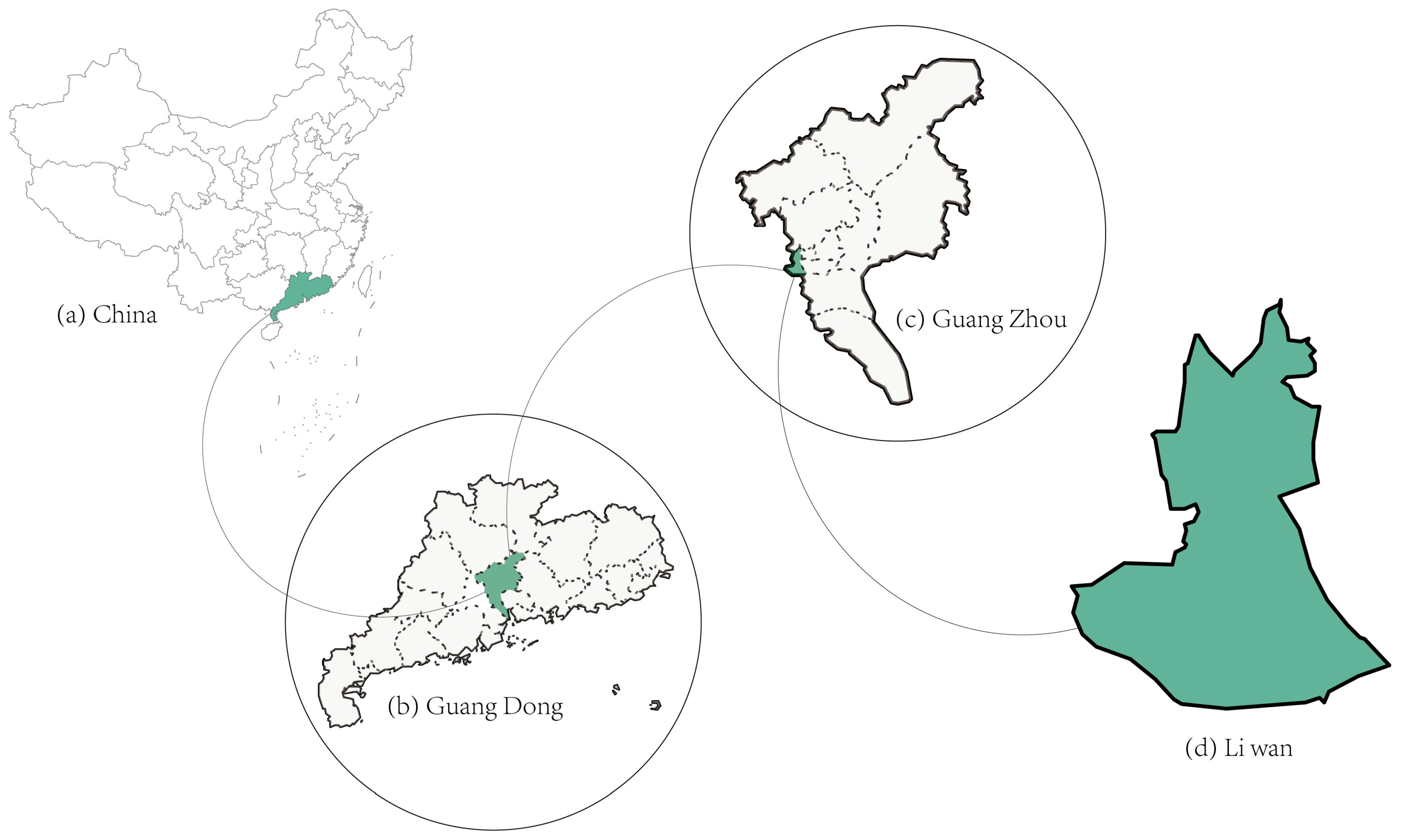
Figure 1. Study area: (a) location of China; (b) Guangdong Province; (c) Guangzhou City; (d) Liwan District.
Buildings 15 03671 g001
Figure 2. Representative streetscapes of Liwan District.
Buildings 15 03671 g002
Figure 3. Research method flowchart. (Note: arrows indicate processing or data flow).
Buildings 15 03671 g003
Figure 4. Four-Directional Distribution of SVIs.
Buildings 15 03671 g004
Figure 5. Identification of objective elements using image segmentation techniques.
Buildings 15 03671 g005
Figure 6. Five Visual Metrics and Spatial Characteristics in Streetscapes: (a) Greenness, (b) Openness, (c) Enclosure, (d) Walkability, (e) Imageability. Note: Colours are schematic and used for visual clarity.
Buildings 15 03671 g006
Figure 7. Gender comparison across four PRS dimensions. Note: Shaded boxes represent the interquartile range and the central line indicates the median.
Buildings 15 03671 g007
Figure 8. Pearson Correlations Between Five Key Visual Metrics and the Four PRS Dimensions. ** p < 0.01.
Buildings 15 03671 g008
Figure 9. The perception map of five key visual metrics: (a) Greenness; (b) Openness; (c) Enclosure; (d) Walkability; (e) Imageability.
Buildings 15 03671 g009
Figure 10. Entire perceptual maps of four perception indicators: (a) Fascination; (b) Being Away; (c) Compatibility; (d) Extent.
Buildings 15 03671 g010
Figure 11. Restorative Perception Clusters: Image and Segmentation Examples.
Buildings 15 03671 g011
Figure 12. K-means Clustering Result Map: (0) Low/(1) Medium/(2) High Recovery Perception. Note: Each dot represents one SVI location aggregated from four directions.
Buildings 15 03671 g012
Table 1. Description of Five Key Visual Metrics for Perceptual Analysis.
IndicatorFormulaFormula Explanation
Greenness G i = 1 4 n = 1 4   V n + 1 4 n = 1 4   T n V n denotes the percentage of Vegetation pixels; T n denotes the percentage of Terrain pixels; the sum indicates the total number of green pixels in each image.
Openness O i = 1 4 n = 1 4   S K n S K n denotes the percentage of sky pixels. The sum indicates the total number of sky pixels in each image.
Enclosure E i = 1 4 n = 1 4   B n + 1 4 n = 1 4   V n + 1 4 n = 1 4   W n B n denotes the percentage of building pixels. V n is the percentage of Vegetation pixels. W n is the percentage of Wall pixels. The sum indicates building, vegetation coverage and wall from four directions.
Walkability W i = 1 4 n = 1 4 S W n + + 1 4 n = 1 4   T n + 1 4 n = 1 4 V n 1 4 n = 1 4 R n + 1 4 n = 1 4 S W n S W n denotes the percentage of sidewalk pixels; T n denotes the percentage of Terrain pixels;
V n denotes the percentage of Vegetation pixels. R n denotes the percentage of road pixels. The equation quantifies walkability by measuring the visual proportion of sidewalks, fences and vegetation coverage relative to roads.
Imageability I i = 1 4 n = 1 4   B n + 1 4 n = 1 4   S W n +
1 4 n = 1 4   S K n + 1 4 n = 1 4   V n
B n denotes the percentage of building pixels. S W n denotes the percentage of sidewalk pixels. S K n denotes the percentage of sky pixels. V n denotes the percentage of Vegetation pixels. The equation reflects the imageability of streets, highlighting building, natural elements, and visible public features contribute to the richness and diversity of the street scene.
Table 2. The revised Perceived Restorativeness Scale.
DimensionsPRS Statement
Fascination (F)F1—I find this streetscape very attractive.
F2—I would like to spend more time appreciating the scenery here.
Being away (B)B1—This streetscape helps me relax my mind.
B2—This streetscape allows me to temporarily escape from daily stress.
Compatibility (C)C1—This streetscape fits my aesthetic preferences.
C2—I enjoy being active in this visual environment.
Extent (E)E1—This streetscape gives me a sense of freedom and lack of constraint.
E2—This streetscape inspires many positive thoughts in me.
Table 3. Overall fit coefficient of PRS.
CategoryNumberPercentage/%
GenderMale12547.5
Female13852.5
AgeBelow 1820.8
18–2512346.8
26–30176.5
31–406524.7
41–503312.5
51–6093.4
Above 60145.3
Relevant industryYes16462.4
No9937.6
Table 4. Regression coefficients of PRS predictors.
FascinationBeing AwayCompatibilityExtent
tptptptp
Greenness13.3910.000 **16.9230.000 **18.5620.000 **18.1260.000 **
Openness−8.8290.000 **−9.8010.000 **−9.230.000 **−10.1680.000 **
Enclosure−6.140.000 **−6.7110.000 **−6.750.000 **−7.1660.000 **
Walkability2.0910.037 *2.0630.039 *0.8160.4151.2470.213
Imageability4.5260.000 **4.730.000 **4.1880.000 **4.6750.000 **
R20.4420.5370.5330.544
F239.181,
p = 0.000
349.867,
p = 0.000
344.355,
p = 0.000
360.174,
p = 0.000
Note: The dependent variables are the predicted values of Fascination, Being Away, Compatibility, and Extent. * p < 0.05 ** p < 0.01.
Table 5. Visual elements identified after segmentation of BSVIs.
IndicatorsVisual ElementsMaxMinMeanS.D.
segmentation
visual elements
road0.4500.0400.2480.075
building0.7800.0000.1990.160
vegetation0.7000.0000.1950.143
sky0.5200.0000.1820.130
sidewalk0.1700.0000.0300.030
fence0.2100.0000.0220.029
wall0.3400.0000.0220.037
terrain0.3000.0000.0130.028
Visual perception indicesGreenness0.7500.0000.2080.152
Openness0.5200.0000.1820.130
Enclosure0.7900.0200.4160.155
Walkability3.5000.0000.2560.296
Imageability0.8800.3200.6060.074
Disclaimer/Publisher’s Note: The statements, opinions and data contained in all publications are solely those of the individual author(s) and contributor(s) and not of MDPI and/or the editor(s). MDPI and/or the editor(s) disclaim responsibility for any injury to people or property resulting from any ideas, methods, instructions or products referred to in the content.