Article

Bridging World Heritage and Local Heritage: Incorporating the Buffer Zone Concept into Chinese Architectural Heritage Protection

1
College of Urban and Rural Construction, Shanxi Agricultural University, Jinzhong 030801, China
2
Shanxi Academy of Ancient Building and Painted Sculpture & Fresco Preservation, Taiyuan 030012, China
*
Author to whom correspondence should be addressed.
Buildings 2025, 15(20), 3652; https://doi.org/10.3390/buildings15203652
Submission received: 29 August 2025 / Revised: 30 September 2025 / Accepted: 4 October 2025 / Published: 10 October 2025
(This article belongs to the Section Architectural Design, Urban Science, and Real Estate)

Abstract

Buffer zones are essential for the protection of the Outstanding Universal Value (OUV) of World Heritage properties. In China, to address the limitations of the prevailing “two-line” delineation system for architectural heritage protection, this study introduces the concept of buffer zone as a new perspective on heritage management. Focusing on the Cao Family Compound—a representative residence of Shanxi Merchants—this research situates the site within a broader cultural network to fully articulate its historical and social values. The methodology unfolds in three phases: (1) comprehensive identification of 47 spatial elements contributing to the compound’s significance, through field investigation, literature review, analysis of historical imagery and architectural drawing, and oral history interview; (2) systematic evaluation of each element’s value contribution to the compound based on six criteria across two dimensions, employing the Analytic Hierarchy Process (AHP) and Weighted Sum Method (WSM); (3) spatial visualization and hierarchical buffer zone delineation conducted via ArcGIS-based data modeling and the Natural Breaks classification method. This integrated approach establishes a holistic and structured framework that bridges architectural heritage with its setting, providing practical guidance for policymakers and conservation practitioners.

Graphical Abstract

1. Introduction

In the management of World Heritage property, buffer zones are clearly defined areas located outside and adjacent to the boundaries of the core property. According to the 2005 Operational Guidelines, buffer zones should encompass important views and other areas or attributes that are functionally important for supporting the property and its protection [1]. By mitigating external threats and safeguarding these associated elements, buffer zones help ensure the integrity and authenticity of World Heritage properties [2], thereby protecting and sustaining their Outstanding Universal Value (OUV) [3,4].
Based on the above consensus, Lake C. L. classifies buffer zones according to the types of external threats to heritage properties, such as visual buffer zones [5,6,7], environmental buffer zones [8,9,10], human activity buffer zones [11], affiliated elements buffer zones [12], and opportunity buffer zones [13]. Among these, affiliated elements buffer zones may include: (1) elements that contribute to the OUV of the core site but are in a poor state of conservation or lack adequate regulatory protection. (2) elements that do not themselves demonstrate OUV but support it through specific cultural or physical features [14,15]. These associated elements are critical for maintaining spatial continuity, cultural coherence, and visual integrity. For example, in France, the relationship between the Plain of Languedoc and the practice of transhumance in the Causses and Cévennes justifies protecting an area outside the official World Heritage boundary [16]; in China, the buffer zones of the Beijing Central Axis include historic water channels, roads, and cultural areas surrounding the nominated property [17].
Beyond classification, scholars have proposed a range of criteria for buffer zone delineation. Dey, A. et al. identified nine dimensions—including visual integrity, architectural integrity, urban landscape, natural features, people’s perception, historical integrity, intangible heritage, boundary demarcation, and laws and regulations [18]. In practice, however, most heritage sites prioritize only visual integrity [19,20,21] and legal frameworks. Complementing these approaches, Yin, J. et al. emphasized functional integrity in their study of the Kaiping Diaolou and villages, advocating buffer zone delineation that reflects the spatial distribution and organization of functions [22]. Collectively, these perspectives underscore the need for a holistic framework for buffer zone delineation that integrates diverse dimensions to ensure the sustained protection and management of heritage values.
Expanding on this, the 2011 UNESCO Recommendation on the Historic Urban Landscape (HUL) conceptualizes urban heritage as the result of a historical layering of cultural and natural values and attributes, and advocates a landscape approach that integrates heritage conservation within broader urban and geographical contexts [23,24,25]. As a result, the role of buffer zones has expanded from narrowly defined protective boundaries to encompassing wider settings [26,27], making holistic and systematic conservation strategies indispensable [28]. Some scholars advocate using a landscape approach, a holistic management concept or integrated strategy that emphasizes cross-scale and cross-disciplinary collaboration as well as multi-stakeholder participation, to achieve sustainable and resilient heritage development [29,30,31].
In China, the prevailing approach to architectural heritage protection is the “two-line” delineation system, comprising the core protection zone and the construction control zone [32]. Although this system provides a legal framework, rapid urbanization, commercialization, and tourism development have led to significant degradation of heritage settings. For example, the demolition of traditional residential courtyards around the Qiao Family Compound in Qixian County [33], as well as the encirclement of Guanyin Hall in Changzhi by high-rise buildings, illustrate this trend. Such cases reveal that spatial elements closely associated with the significance of the heritage site—particularly intangible aspects—remain insufficiently integrated into current protection frameworks.
Chinese architectural heritage is profoundly shaped by the traditional philosophy of “Harmony between Heaven and Humanity,” which emphasizes the inseparable relationship between architecture and nature, encompassing the surrounding environment, wider landscapes, and celestial phenomena [34,35,36]. From this perspective, effective conservation requires approaches that reflect regional identity and cultural interconnectedness.
Against this backdrop, this study takes the Cao Family Compound as a representative case of Chinese architectural heritage. Drawing on the buffer zone concept from World Heritage practices, it proposes a localized framework that addresses the limitations of the conventional two-line system and promotes holistic conservation strategies. The approach centers on identifying culturally associated spatial elements in the surrounding environment, evaluating their contribution to heritage value, and applying GIS-based analysis to delineate buffer zones that more fully embody the historical and social significance of the site.

2. Materials and Methods

2.1. Study Area

2.1.1. Architectural Heritage

The Cao Family Compound is located in the northeastern part of Beiwang Village, about 5 km southwest of Taigu District, Jinzhong City, Shanxi Province (Figure 1). It is a representative residence of the prominent Shanxi merchant Cao clan during the Ming and Qing dynasties (1368–1911), reflecting the history of the family and the commercial success of the Shanxi Merchants. The term “Cao Family Compound” specifically refers to the architectural complex centered on Sanduo Tang, the best-preserved branch complex of the Cao family. In 2006, it was designated as a Major Historical and Cultural Site Protected at the National Level.
The compound faces south, measuring 98 m from north to south and 110 m from east to west, with a total area of 1.06 hectares. It consists of two sections: a residential complex to the east and a garden to the west (Figure 1). The eastern residential section is organized along five parallel north–south axes, which are further divided by an east–west passageway into an inner compound (north) and an outer compound (south). The inner compound comprises: Duozi Yuan (Many Sons Courtyard), the affiliated yard of Duozi Yuan, Duofu Yuan (Many Blessings Courtyard), Duoshou Yuan (Many Longevity Courtyard), and the affiliated yard of Duoshou Yuan. These three core courtyards (Many Sons, Blessings, and Longevity) give the compound its name Sanduo. The outer compound includes three main courtyards and two side courtyards. This recognition highlights its importance as a tangible representation of Shanxi Merchant culture and its exemplary status within the northern residential architectural tradition of the Ming and Qing dynasties.

2.1.2. Historical Evolution

The historical development of the Cao Family Compound can be divided into three distinct phases: Phase I (Formation Period), Phase II (Flourishing Period), and Phase III (Decline Period) (Figure 2).
Phase I: Formation Period. During the Hongwu reign of the Ming Dynasty (1368–1398), Cao Bangyan, the founding ancestor of the Cao family, relocated his household from Huata Village in Taiyuan, Shanxi, to Beiwang Village in Taigu, where they engaged exclusively in agriculture. In the third year of the Chongzhen reign of the Ming Dynasty (1630), the 14th-generation descendant, Cao Sanxi, ventured beyond the Great Wall to Sanzuota (present-day Chaoyang County, Liaoning Province), where he sold tofu and distilled spirits, laying the foundation for the Cao family’s commercial enterprise [37].
Phase II: Flourishing Period. In 1803 (the 8th year of the Jiaqing reign), the 15th-generation descendants, Cao Yutai and Cao Yufan, divided the family estate, forming the “East Gate Branch” and “West Gate Branch” based on their residential locations. By the 16th generation, Cao Zhaoyuan of the East Gate Branch introduced a joint-stock model—Cao Qihe—to manage family businesses collectively. After internal restructuring, it was renamed Liude gong. With growing commercial success, the Cao family built over ten grand compounds in Beiwang Village, including the Fu (Blessing), Lu (Prosperity), Shou (Longevity), and Xi (Happiness) courtyards.
Phase III: Decline Period. After the Republic of China was established in 1912, the younger generations neglected family duties, indulged in opium, and sold estates such as Dungu Tang and Fushan Tang. The Japanese invasion further accelerated the decline: the September 18th Incident of 1931, which marked Japan’s occupation of Northeast China, and the July 7th Incident of 1937, which triggered the full-scale war of resistance between China and Japan, severely disrupted the Cao family’s businesses and led to the occupation of their Beiwang compound. Later, the Cultural Revolution (1966–1976), a nationwide political movement that attacked the “Four Olds”, caused additional damage to the estates. During China’s reform and opening-up, modernization led to the demolition of many old residences, including the Fu, Lu, and Xi compounds, leaving only the Shou compound (Sanduo Tang) intact. Following its restoration in 1995, Sanduo Tang now operates as a museum under the name Cao Family Compound, preserving the legacy of Shanxi Merchants [38,39].

2.1.3. Core Values of Architectural Heritage

Based on the tangible remains and historical development of the Cao Family Compound, its core values can be summarized in two aspects:
(1) Historical value: As the principal residence of the Cao clan, the compound bears witness to the development of Shanxi Merchants in central Shanxi since the Ming and Qing dynasties. It illustrates a clan-based commercial system rooted in a small-scale peasant economy during the late feudal period of China.
(2) Social value: The Cao Family Compound reflects the lifestyle, social networks, and broader social organization of Shanxi merchant families in the central Shanxi region during the Ming and Qing periods.

2.1.4. Setting and Limitations of the Existing Protection Zones

The Cao Family Compound is located in the traditional village of Beiwang, where the historic streets and alleys remain relatively well-preserved. Scattered around the compound are residential and religious buildings historically associated with the Cao clan. Sharing the same cultural background as the compound itself, these surrounding architectural and street elements—although fragmented and in a state of deterioration—collectively bear witness to the full trajectory of the Cao clan’s commercial development and daily life. Their enduring cultural association reinforces the Cao Family Compound’s historical and social significance within the broader heritage setting.
Currently, the legal protection of the Cao Family Compound is organized into two zones: the core protection zone and the construction control zone. The core protection zone extends 15 m beyond the eastern wall, 20 m beyond the northern and southern walls, and 60 m beyond the western wall. Surrounding this, the construction control zone extends 62 m to the east, 45 m to the south, 20 m to the west, and 125 m to the north. The core protection zone encompasses the main buildings of the Cao Family Compound, including Sanduo Tang and Ningfu Tang 1-2), while the construction control zone covers nearby structures such as Wugui Tang 1-1) and the Cao Ancestral Hall 1-4). It should be noted that, in the surrounding environment, Wugui Tang 1-1), Guandi Temple 3-1), and Huaiyi Tang 1-14) are county-level Historical and Cultural Sites, each legally designated with its own core protection zone and construction control zone [40,41] (Figure 3).
However, other tangible and intangible elements that are closely connected to its cultural context remain inadequately integrated within the current protection framework. This limitation diminishes the overall value of the Cao Family Compound and, to some extent, hinders the comprehensive presentation of its profound cultural significance. The concept of World Heritage buffer zones provides an effective approach to re-establish the connection between heritage and its surrounding environment.

2.2. Methods and Framework

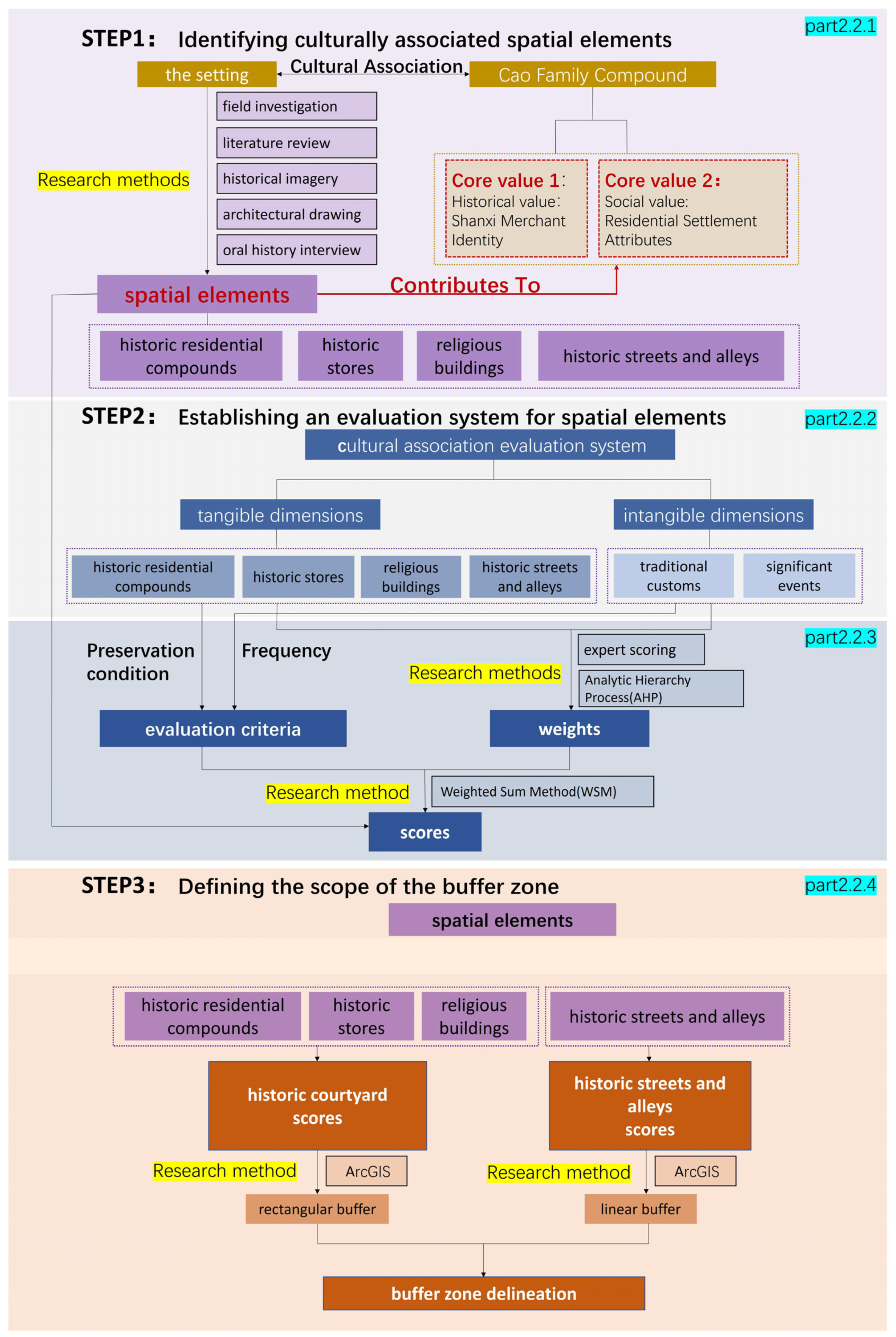
The research methods and framework are shown in Figure 4, which outlines the three-step procedure: (1) identifying spatial elements, (2) establishing the evaluation system, and (3) delineating the buffer zone. The details of each step are as follows:
Step 1 (Foundation): Identification of culturally significant spatial elements through field investigation, literature review, analysis of historical imagery and architectural drawings, and oral history interviews.
Step 2 (Core Methodology): Based on the attributes of the spatial elements, a six-criteria evaluation system was established, covering both tangible and intangible dimensions. The weights of each criterion were determined through expert scoring and the Analytic Hierarchy Process (AHP). In addition, scoring standards were set according to preservation conditions (for tangible criteria) and frequency of occurrence (for intangible criteria).
Step 3 (Outcome): Synthesis of scores and spatial delineation of the buffer zone using ArcGIS.

2.2.1. Identifying Culturally Associated Spatial Elements

Through comprehensive field investigation, literature review, comparative analysis of historical imagery and architectural drawing (Figure 5), and oral history interview (Appendix A), this study identified 47 spatial elements within the setting of the Cao Family Compound that are closely and culturally associated with it. These elements are classified into four primary categories: historic residential compounds, historic stores, religious buildings, and historic streets and alleys (Table 1).
Among these, the spatial elements in the three categories—excluding historic stores—could all be accurately georeferenced. Due to gaps in historical records and difficulties in verifying exact locations, only four historic stores (Hemp Shop, Dingyi Wine Shop, Yiji Pawnshop, and Liudegong Management Organizations) could be precisely located. As a result, 38 spatial elements across all four categories were successfully positioned within the spatial framework (Figure 5).

2.2.2. Establishing an Evaluation System for Spatial Elements

The spatial elements culturally associated with the Cao Family Compound exhibit both tangible and intangible dimensions. To assess the extent of cultural association, this study established a two-dimensional evaluation framework comprising six criteria.
The tangible dimensions include four criteria corresponding to spatial typologies: A) historic residential compounds; B) historic stores; C) religious buildings; D) historic streets and alleys.
The intangible dimensions include two criteria capturing non-physical cultural connections: E) traditional customs; F) significant events [42,43].
This framework forms the basis for assessing the cultural association of each spatial element, which represents the element’s contribution to the overall value of the Cao Family Compound as the heritage core (Table 2).

2.2.3. Determining Weights and Evaluation Criteria

This study employs the expert scoring method to establish a pairwise comparison matrix and then applies the Analytic Hierarchy Process (AHP) to calculate the weights of each criterion [44], which indicate the degree of each criterion’s contribution to the overall heritage value of the compound.
First, five experts with professional expertise and extensive experience in heritage conservation, urban planning, architectural history, and folklore studies were selected for structured interviews. During the interviews, each expert was provided with comprehensive written materials, including detailed explanations for each criterion and the scoring guidelines, ensuring that evaluations were conducted within a standardized cognitive framework.
Subsequently, based on the completed scoring questionnaires, a 6 × 6 pairwise comparison matrix was developed:
A = a i j = 1 a 1 a 2 a 1 a n a 2 a 1 1 a 2 a n a n a 1 a n a 2 1
a i i = 1 , a i j = a i / a j = 1 / a j i , a i j 0
a i j —relative importance of criterion i compared to criterion j; a j i —relative importance of criterion j compared to criterion i.
Yaahp software (version 10.1) was utilized to compute the weights for each criterion. Throughout this process, particular emphasis was placed on assessing the consistency of the judgment logic to ensure the scientific rigor and reliability of the results. When the consistency ratio (CR) is below 0.1, the judgment matrix is considered to exhibit an acceptable level of consistency.
Based on the calculations, the weights for each criterion were determined (Table 3).
The specific scoring rules and criteria are defined as follows:
(1)
Tangible dimensions
Historic residential compounds, historic stores, and religious buildings are evaluated based on their preservation status. To emphasize their cultural significance, even lost structures are assigned a baseline score of 10 points. The scoring system increases incrementally by 30 points based on preservation levels, as follows:
Disappeared: 10 points
Poorly preserved: 40 points
Generally preserved: 70 points
Well-preserved: 100 points
Similarly, historic streets and alleys are assessed based on their preservation status. Existing streets receive 100 points, while lost streets are given a score of 0 [44].
(2)
Intangible dimensions
Traditional customs and public events are quantified according to their frequency. A 0–100 scoring scale is applied through proportional grading. According to literature and oral history, Cao Ancestral Hall has the highest number of traditional customs recorded (3 occurrences), while Huaiyi Tang hosts the greatest number of public events (7 occurrences). These maximum values serve as benchmarks for gradient classification.
Finally, based on the established weights and scoring rules, the contribution of each spatial element to the value of the Cao Family Compound was calculated using the Weighted Sum Model (WSM).
V = i = 1 n w i · x i
w i —the relative weight of criterion i; x i —the relative score of criterion i.

2.2.4. Defining the Scope of the Buffer Zone

Drawing on the theory of distance decay in geography, the influence of heritage elements on their surroundings is not isolated but varies according to the magnitude of their value contribution. Elements with higher value contributions generally require a broader protection range to minimize external interference. To capture this relationship, this study employs a linear function to quantitatively link value contribution to buffer distance.
Based on this model, the value contributions of spatial elements to the Cao Family Compound were visualized using ArcGIS, which provided the basis for delineating the buffer zone. The extent of the buffer zone was determined as follows:
D =   k   ×   V
D is the buffer distance, measured in meters (m).
V is the value contribution of each spatial element.
k is the scaling adjustment coefficient, used to control the adaptability of the buffer range and ensure that the impact range for different types of spatial elements is reasonable. In this study, k was set to 0.5. (The coefficient of 0.5 was determined through repeated trials to ensure that the buffer distance adequately covered the courtyards, adjacent streets, and the scale of nearby street-front buildings.)
A rectangular buffer (polygon buffer) is established based on the building’s boundary, while a linear buffer (line buffer) is applied to the streets and alleys.

3. Results

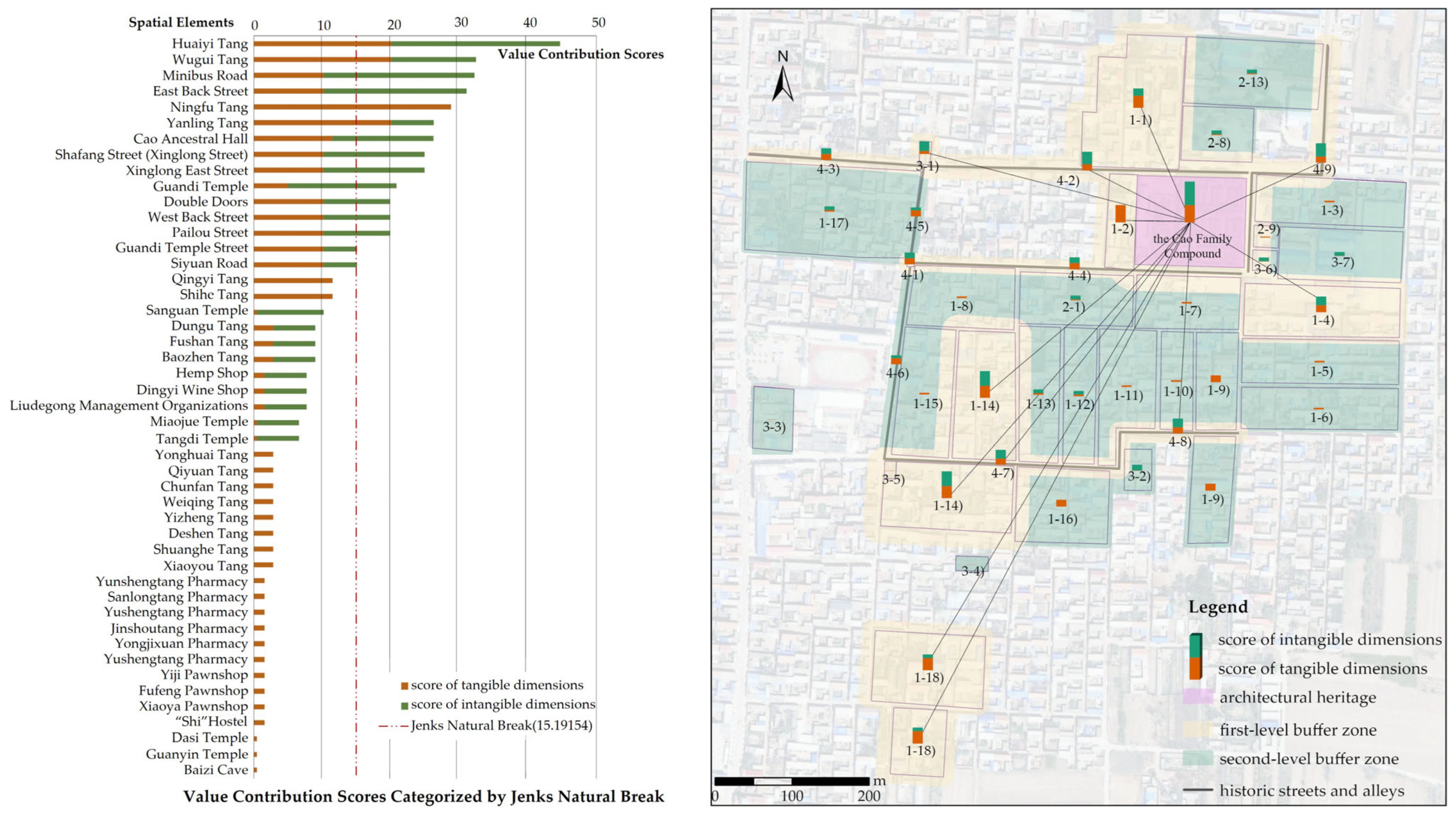
The scores of 47 spatial elements were classified into two levels using the Jenks Natural Breaks classification method [45]. The resulting threshold was 15.19154. Spatial elements with scores greater than this value were designated as part of the first-level buffer zone, whereas those with scores less than or equal to it were assigned to the second-level buffer zone (Figure 6).
The first-level buffer zone includes three spatial clusters:
(1)
The cluster, consisting of Wugui Tang, Ningfu Tang, and the Cao Ancestral Hall, is a representation of the traditions of clan identity and rituals.
(2)
The cluster, centered on Huaiyi Tang—the former residence of Cao Runtang, the 21st-generation descendant of the Cao family—not only reflects the typical spatial layout of a Shanxi Merchant residence but also embodies the Shanxi Merchant spirit of charity and patriotism.
(3)
The cluster centered on Yanling Tang, although originally the residence of the Wu family, is famous for the production of the Guilingji and bears witness to the rise and fall of the Cao Family Compound. It can therefore be regarded as part of the historical space of the Shanxi Merchants, closely connected to the cultural network of the Cao Family Compound.
The second-level buffer zone encompasses areas with relatively lower value contributions.
Based on the delineation results, it is essential not only to define the spatial extent of the buffer zones but also to establish corresponding management recommendations. These recommendations are differentiated by buffer zone levels, ensuring both effective protection and sustainable use. The specific proposals are as follows:
First-level buffer zone recommendations:
(1)
Strictly preserve the authenticity and integrity of the architectural compounds, including materials, craftsmanship, style, and color.
(2)
Maintain the authenticity and integrity of street patterns and the spatial relationship of facades on both sides, avoiding road widening or alterations that would damage their form.
(3)
Ensure the overall layout, functional continuity, and associated cultural connections of the three architectural clusters.
Second-level buffer zone recommendations:
(1)
Maintain regional landscape characteristics and ensure coordination with the core area regarding materials, style, and color.
(2)
Preserve the overall continuity of street patterns and avoid large-scale demolition or alterations.
(3)
Without compromising the core values of the Cao Family Compound, moderate introduction of basic services and public facilities is acceptable to enhance resident engagement and economic benefits, thereby achieving a balance between protection and development.

4. Discussion

4.1. The Buffer Zone

Returning to the concept of buffer zones, there are visual buffer zones, environmental buffer zones, human activity buffer zones, affiliated elements buffer zones, and opportunity buffer zones, among others. Why does this study focus solely on affiliated elements buffer zones? It is undeniable that the Cao Family Compound is also affected by other surrounding environmental threats, such as those related to visual exposure, residents, and opportunistic factors.
(1) Visual buffer zone: The pavilions built atop the roofs of Duozi Yuan, Duofu Yuan, and Duoshou Yuan within the compound provide views of the entire village and the Phoenix Mountain, highlighting issues related to view corridors and skyline protection.
(2) Human activity buffer zone: Field surveys identified instances in which local residents demolished traditional buildings, sold gray bricks, or replaced traditional gray-tiled roofs with blue stainless-steel roofing, posing a threat to the overall historic character of the site.
(3) Opportunity buffer zone: As commercial activities such as dining and lodging are prohibited within the heritage property itself, surrounding areas offer potential for functional supplementation. With proper planning, supporting facilities could be established to meet community needs while reducing pressure on the heritage property.
The situation of the Cao Family Compound is not an isolated case but reflects a widespread phenomenon in the conservation of Chinese architectural heritage. In past practices, cultural associations have often been overlooked, resulting in the disconnection of heritage sites from their historical and cultural contexts during conservation. Therefore, this study’s focus on the affiliated elements buffer zone not only addresses the immediate conservation needs of the Cao Family Compound but also responds to this broader, systemic issue.
In practice, buffer zone delineation should be guided by the Outstanding Universal Value (OUV), authenticity, and integrity of the heritage, as well as by the external threats it faces. A multidimensional overlay or hierarchical approach can be adopted when appropriate. As a management tool, the selection of buffer zone types and their boundaries should ultimately reflect the specific attributes and conservation needs of each heritage site.

4.2. Integrated and Systematic Conservation of the Cao Family Compound

In contrast to the legally designated protection zones, which extend outward in a rectangular form centered on the Cao Family Compound, the buffer zones proposed in this study systematically and holistically incorporate spatial elements that are culturally associated with the compound. This approach is of great significance for presenting the historical and social values of the Cao Family Compound. The buffer zones emphasize the coordinated development between the Cao Family Compound and its setting. By extending beyond the compound’s original 1.06 hectare area, the buffer zones provide new opportunities for community engagement and tourism development [13]. Nevertheless, this innovative delineation method also introduces management challenges. Specifically, while the legally designated protection zones fall solely under the jurisdiction of the cultural heritage authority, the proposed buffer zones require coordinated management among multiple stakeholders [46,47], including heritage authorities, urban construction departments, village committees, and local residents.

4.3. The Importance of Cultural Association

In China, architectural heritage is managed under a “point-line-plane” system, referring, respectively, to individual buildings, building complexes, traditional streets and alleys, and historic cities. Each type of heritage is designated with its own legally defined core protection zone and the construction control zone; in some cases, visual coordination areas are also delineated. These types of heritage are managed independently across different administrative levels, with responsibilities clearly delineated. However, the “association” between architectural heritage entities remains largely unaddressed by current heritage authorities. In other words, cultural association or integrity across heritage components is often excluded from formal protection framework. This fragmented management model, while emphasizing legal demarcations and administrative jurisdictions, falls short in capturing the cultural continuity and lived experiences embedded within the heritage as a whole [48].
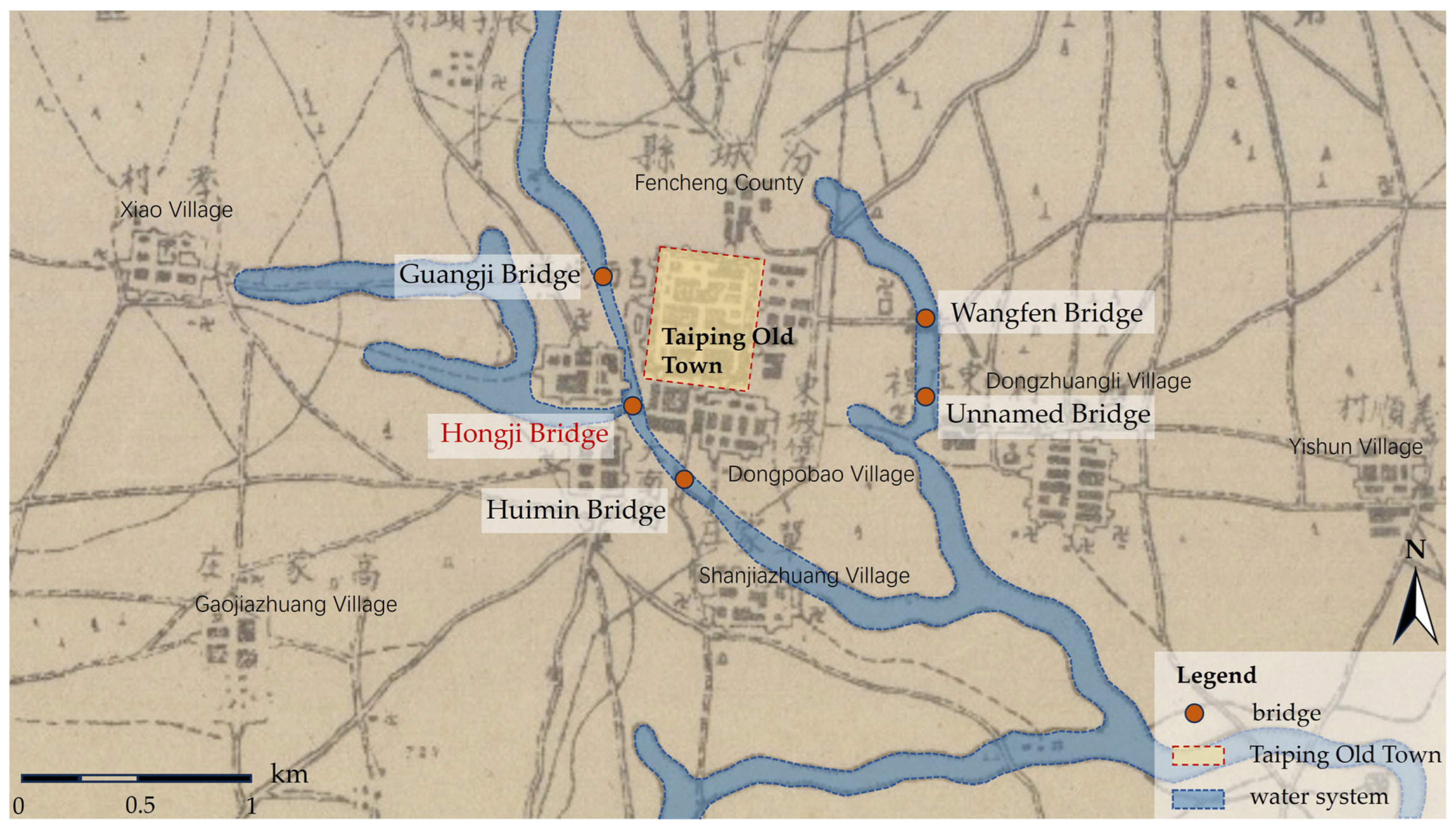
A comparable case can be found in Hongji Bridge, located in Fencheng Town, Xiangfen County, Shanxi Province. As a rare timber-covered bridge dating back to the Jin Dynasty, it has been designated as a Major Historical and Cultural Site Protected at the National Level. When considered from the perspective of cultural association, however, Hongji Bridge represents far more than an isolated architectural relic; it once served as the sole southwestern gateway into the ancient county seat of Taiping. Historical records reveal that commercial shops once lined the streets from the bridge to the southern gate tower of the town, making it a vital commercial corridor [49]. Interviews with local residents indicate that, as late as the 1950s, teahouses on the bridge continued to offer rest and hospitality to passersby. Furthermore, Hongji Bridge and four adjacent bridges—Guangji, Wangfen, Nameless Bridge, and Huimin—collectively formed a seasonal flood-adapted transportation network surrounding the ancient county [49] (Figure 7).
Today, however, commercial activities have declined, riverbeds have dried up, and only Wangfen Bridge remains intact. The cultural associations among these elements have become obscured. Although Hongji Bridge and other key heritage structures within Taiping, including the Drum Tower, County Office Hall, Guandi Temple, and Confucian Temple (each with its own core protection zone and the construction control zone), have been collectively designated as the “Fencheng Architectural Complex,” such classification alone fails to capture their underlying spatial and cultural logic [50,51]. It is through the lens of cultural association that this complex can fully embody the planning principles and everyday life of a historical Chinese county town—something that cannot be conveyed by scattered individual monuments alone. Numerous similar cases exist across China.
In conclusion, uncovering the cultural associations among heritage sites—particularly those in close spatial proximity, including their surrounding natural environments—is essential for accurately interpreting their collective value and achieving effective heritage presentation. As emphasized in the Xi’an Declaration, heritage “derive their significance and distinctive character from their meaningful relationships with their physical, visual, spiritual and other cultural contexts and settings” [52,53]. Cultural association, therefore, should be regarded as an indispensable component of China’s heritage conservation framework [54].

4.4. Context-Sensitive Strategies for Heritage Buffer Zone Design

In Japan, the “Preservation Districts for Groups of Traditional Buildings” system reflects a holistic approach to heritage conservation. Notably, even components not meeting the official designation criteria are preserved if they are spatially or functionally connected to designated properties [55,56]. This principle is clearly exemplified in the historic villages of Shirakawa-go and Gokayama, where the designated property is intended not only to protect the Gassho-style houses but also to conserve the surrounding shrine grove, woodlands, rice paddies, and irrigation canals [57,58].
In the case of Iran’s Anahita Temple, a perception-based buffer zone is developed with the active participation of local communities [59]. Rather than strictly adhering to administrative or legal designations, the buffer zone incorporates elements such as agricultural fields, springs, rivers, hills, markets, and commercial waystations—features deeply embedded in the collective memory of the community. This approach not only preserves the spatial and cultural integrity of the heritage site but also establishes meaningful correspondence between the physical landscape and people’s mental maps of the place [60].
This approach aligns closely with the conceptual framework of this study, which regards the Cao Family Compound not as an isolated heritage entity but as a central node within a broader cultural network. The buffer zone proposed in this research incorporates spatial elements with cultural associations, providing a more systematic strategy for preserving both the tangible fabric and the intangible values of the heritage site.
However, compared to the cases of Japan and Iran, this study also exhibits several distinct differences. The Cao Family Compound is situated within the context of a traditional Chinese clan-based settlement, where its cultural network is primarily manifested through the coexistence of ancestral courtyard complexes, commercial activities, and the spatial texture of streets and alleys [61,62]. In contrast, the Japanese case places greater emphasis on the symbiotic relationship between built heritage and the natural environment, while the Iranian example highlights the community’s active construction of heritage space based on collective memory.
Moreover, the delineation of the buffer zone for the Cao Family Compound remains at a theoretical and exploratory stage. It has yet to be integrated into formal policy frameworks and currently lacks adequate legal support and mechanisms for public participation [63,64]. By contrast, the approaches adopted in Japan have been partially institutionalized and benefit from more mature governance structures [55]. Therefore, future conservation efforts for the Cao Family Compound should seek institutional breakthroughs in legal regulation, multi-stakeholder collaboration, and cultural identity building, in order to advance from point-based control toward a network-oriented model of heritage governance.

5. Conclusions

This study critically examines the limitations of the traditional “two-line” approach in delineating protection zones for Chinese architectural heritage and draws upon methodologies used in World Cultural Heritage practices. It proposes a cultural association approach to buffer zone delineation that aligns with regional characteristics and heritage attributes. By situating architectural heritage within a broader cultural network, the method systematically identifies and integrates both tangible elements (such as historic buildings and traditional street patterns) and intangible components (such as historical functions, belief systems, and socio-cultural practices) present in the surrounding environment. It then evaluates the degree to which these elements contribute to cultural integrity and historical continuity, thereby determining the spatial extent of the buffer zone. Through this process, a holistic and structured framework for architectural heritage conservation is established, one that addresses both the historical and social values of heritage.
While the proposed cultural association approach provides a conceptual framework for integrating tangible and intangible values, its practical implementation requires a clear and operationalizable method for translating value contributions into spatial buffer ranges. For historic compounds, buffer distances are indispensable. The buffer distance is influenced by multiple factors. It may also be affected by other factors, such as the area, vertical height, color, and material of the spatial elements. In the absence of sufficient empirical data to support more complex nonlinear models, a linear function represents the most common, conservative, and intuitive approach. The adoption of a linear relationship ensures a strict monotonic correspondence between value contribution and buffer distance, thereby avoiding discontinuities or unreasonable results. The coefficient of 0.5 was determined through repeated trials to ensure that the buffer distance adequately covered the courtyards, adjacent streets, and the scale of nearby street-front buildings. Supplementary note: From a methodological perspective, the formula “D = k × V” should be considered a heuristic modeling choice rather than a definitive conclusion. It provides a transparent and verifiable framework for quantifying heritage buffer zones and lays the foundation for future research, such as incorporating additional spatial variables, exploring nonlinear functions, or conducting cross-case comparisons.
Although this modeling approach offers a structured and replicable starting point, it also highlights the limitations of relying solely on quantitative techniques. In practical application, techniques such as GIS spatial analysis and AHP hierarchical analysis can enhance the objectivity and replicability of evaluations; however, architectural heritage and its settings embody deeply interwoven social, historical, and cultural dimensions that cannot be fully captured by quantitative tools alone. Value assessments inevitably require interdisciplinary interpretation, and the recognition of heritage value remains a dynamic process that evolves over time. Consequently, it is essential to integrate insights from long-term socio-historical developments, local community perspectives, and comprehensive archival research to ensure that assessment outcomes are both rigorous and inclusive. Future research could further test and refine this approach across different heritage types and regional contexts, contributing to the broader discourse on integrating tangible and intangible values in heritage protection strategies worldwide.

Author Contributions

Y.C., conceptualization, methodology, investigation, funding acquisition, writing—original draft, writing—review and editing; R.H., methodology, investigation, writing—review and editing. Z.L., data curation, software and visualization. All authors have read and agreed to the published version of the manuscript.

Funding

This research was funded by Basic Research Program of Shanxi Province, grant number 202303021222049; Philosophy and Social Science Planning Project of Shanxi Province, grant number 2024QN047; Innovation Project for Postgraduate Education of Shanxi Province, grant number 2024SJ148.

Data Availability Statement

The data will be available from the corresponding author upon reasonable request.

Conflicts of Interest

The authors declare no conflicts of interest.

Appendix A

The interview framework covered 9 categories: historic streets and alleys, historic stores, historic residential compounds, religious buildings, folk carnival activities (traditional customs), sacrificial rituals (traditional customs), weddings (traditional customs), funerals (traditional customs), and escort agency activities (significant events).
1.
Historic Streets and Alleys
  • Have any historic streets and alleys in Beiwang Village undergone renaming over time?
  • Were the roads linking the Cao family compounds originally public village roads or internal family roads?
  • Have the historic streets and alleys retained their original spatial fabric, or have there been changes in their location and scale?
2.
Historic Stores
  • What Cao family stores once existed in Beiwang Village (e.g., Yunshengtang Pharmacy, Dingyi Distillery, Yiji Pawnshop, hemp shop, etc.)?
  • Where were these stores specifically located?
  • Are any of the Cao family’s stores still preserved today, and who currently owns them?
  • What was the relationship between Yanling Tang and the Cao family?
  • During the New Year, what were the specific times and procedures for the managers (zhanggui) of the Cao family’s various shops to return to the Cao Family Compound to report on their yearly business?
3.
Historic Residential Compounds
  • Where did the Cao family migrate from Huata Village, Taiyuan, to Beiwang Village?
  • When and where were the Cao family’s compounds (the Fu [Blessing], Lu [Prosperity], Shou [Longevity], and Xi [Happiness] courtyards, as well as other major compounds) constructed?
  • What was the extent of the Cao family’s compounds at their peak?
  • When and why were the Cao family compounds demolished?
  • Historically, did the Cao family compounds have enclosing walls, and what were the orientations of their main gates?
  • Besides the surviving multi-story buildings of Sanduo Tang and WuguTang, did any of the other demolished Cao family buildings also consist of multi-story structures?
4.
Religious Buildings
  • What temples existed in Beiwang Village (e.g., Guandi Temple, Sanguan Temple, Miaojue Temple, etc.)?
  • Where were these temples specifically located?
  • Have the religious buildings retained their original functions?
  • Are there any stories, legends, or oral traditions associated with these religious buildings?
5.
Folk Carnival Activities
  • Where were the stages for opera (Yangge) performances located, both within the Cao family compounds and in the village?
  • When and where did the Cao family organize opera performances?
  • When and where were puppet shows and shadow plays performed?
  • What were the specific locations and performance routes of the village’s folk carnival (Shehuo) activities?
  • What was the procession route for the “back-stick” (beigun) performance?
  • What was the procession route for the “iron-stick” (tiegun) performance?
  • What was the procession route for the “carrying-pavilion” (taige) performance?
6.
Sacrificial Rituals
  • What were the routes, procedures, and participants for sacrificial rituals at the Cao Ancestral Hall?
  • What were the routes and procedures for sacrificial rituals at the Cao family cemetery?
  • What religious activities did the Cao family organize in association with local temples (e.g., Guandi Temple)?
  • Were the temple fairs in Beiwang Village collectively organized by the village, and were they associated with the Cao family?
7.
Weddings
  • What were the routes and procedures for wedding processions in Cao family marriages?
  • What were the routes and procedures for daughters’ bridal processions when leaving the Cao family compound?
  • Were there differences between marriage customs during the Republican era and those of earlier historical periods?
8.
Funerals
  • What were the routes and procedures of funeral processions in the Cao family?
  • What were the routes, timings, and procedures for ancestor worship during the Qingming Festival and the Ghost Festival (Zhongyuan)?
9.
Escort Agency Activities
  • With the escort agency divided into eastern and western bureaus, what were the daily patrol routes, and where were the training grounds located?
  • Did the existence of the escort agency contribute to the development of martial arts (Xingyiquan) in the local area?
  • What was the relationship between the escort agency and the commercial development of the Cao family?
  • Were there any renowned escort masters associated with the agency?

References

  1. UNESCO World Heritage Centre. Operational Guidelines for the Implementation of the World Heritage Convention; WHC-05/2; UNESCO: Paris, France, 2005; Available online: https://whc.unesco.org/en/guidelines/ (accessed on 14 August 2025).
  2. Gullino, P.; Larcher, F. Integrity in UNESCO World Heritage Sites. A comparative study for rural landscapes. J. Cult. Herit. 2013, 14, 389–395. [Google Scholar] [CrossRef]
  3. Martin, O.; Piatti, G. (Eds.) World Heritage and Buffer Zones: International Expert Meeting on World Heritage and Buffer Zones, Davos, Switzerland, 11–14 March 2008; World Heritage Papers 25; UNESCO World Heritage Centre: Paris, France, 2009; Available online: https://whc.unesco.org/en/documents/101965/ (accessed on 3 May 2025).
  4. Bay, M.A.; Alnaim, M.M.; Albaqawy, G.A.; Noaime, E. The Heritage Jewel of Saudi Arabia: A descriptive analysis of the heritage management and development activities in the At-Turaif District in Ad-Dir’iyah, a World Heritage Site (WHS). Sustainability 2022, 14, 10718. [Google Scholar] [CrossRef]
  5. Greater London Authority. London View Management Framework: Supplementary Planning Guidance; Greater London Authority: London, UK, 2012. Available online: https://www.london.gov.uk/programmes-strategies/planning/implementing-london-plan/london-plan-guidance-and-spgs/london-view-management#the-document-32755-title (accessed on 17 March 2025).
  6. Ashrafi, B.; Kloos, M.; Neugebauer, C. Heritage Impact Assessment, beyond an assessment tool: A comparative analysis of urban development impact on visual integrity in four UNESCO World Heritage Properties. J. Cult. Herit. 2021, 47, 199–207. [Google Scholar] [CrossRef]
  7. Lee, J. Zoning scenic areas of heritage sites using visibility analysis: The case of Zhengding, China. J. Asian Archit. Build. Eng. 2023, 22, 1–13. [Google Scholar] [CrossRef]
  8. Li, L.; Feng, R.; Xi, J. Ecological Risk Assessment and Protection Zone Identification for Linear Cultural Heritage: A Case Study of the Ming Great Wall. Int. J. Environ. Res. Public Health 2021, 18, 11605. [Google Scholar] [CrossRef]
  9. Liu, J.; Xu, Z.; Chen, F.; Chen, F.; Zhang, L. Flood hazard mapping and assessment on the Angkor World Heritage Site, Cambodia. Remote Sens. 2019, 11, 98. [Google Scholar] [CrossRef]
  10. Smaniotto, N.P.; Moreira, L.F.; Semedo, T.B.; Carvalho, F.; Quintela, F.M.; Nunes, A.V.; Shimano, Y. When drought matters: Changes within and outside Protected Areas from the Pantanal ecoregion. Wetlands 2024, 44, 45. [Google Scholar] [CrossRef]
  11. Chukwuka, A.V.; Nwabuisiaku, C.; Adegboyegun, A.D.; Sharafadeen, O.; Shukwunweizu, M.M. Remotely sensed assessment of mining severity within buffer zones of Osun river: Implications for drinking water quality, biodiversity protection, and status as UNESCO World Heritage Site. Water Air Soil Pollut. 2023, 234, 689. [Google Scholar] [CrossRef]
  12. Carreño, A.M.; Icomos, P. Buffer Zones as a Tool for Protecting World Heritage Sites: The Case of the Heritage Routes. In Proceedings of the ICOMOS Symposium, Hiroshima, Japan, 26 November–1 December 2006; pp. 28–29. [Google Scholar]
  13. Zhang, J.; Xiong, K.; Liu, Z.; He, L.; Zhang, N.; Gu, X.; Chen, D. Exploring the synergy between Karst World Heritage Site’s OUV conservation and buffer zone’s tourism industry development: A case study of the Libo-Huanjiang Karst. Herit. Sci. 2023, 11, 202. [Google Scholar] [CrossRef]
  14. Lake, C.L. Buffer Zones at World Heritage Sites: Recommendations for Implementation and Monitoring Based on the French Experience. Ph.D. Dissertation, University of Florida, Gainesville, FL, USA, 2015. [Google Scholar]
  15. Jiang, B.; Huang, Y.; Chen, Y.; Lu, J.; Yang, T. The distribution pattern and spatial morphological characteristics of military settlements along the Ming Great Wall in the Hexi Corridor region. Buildings 2025, 15, 1136. [Google Scholar] [CrossRef]
  16. UNESCO. World Heritage List. Available online: https://whc.unesco.org/en/list/1153 (accessed on 24 July 2025).
  17. UNESCO. World Heritage List. Available online: https://whc.unesco.org/en/list/1714 (accessed on 24 July 2025).
  18. Dey, A.; Pasupuleti, R.S. Relevance of Buffer Zones in Protecting World Heritage Sites (WHS) in Urban Contexts: Case of Indian WHS. J. Cult. Herit. Manag. Sustain. Dev. 2025; in press. [Google Scholar] [CrossRef]
  19. Sukwai, J.; Mishima, N.; Srinurak, N. Balancing Cultural Heritage Conservation: Visual Integrity Assessment to Support Change Management in the Buffer Zone of Chiang Mai Historic City Using GIS and Computer-Generated 3D Modeling. Land 2022, 11, 666. [Google Scholar] [CrossRef]
  20. Li, Q.; Yuichi, F.; Morris, M. Study on the Buffer Zone of a Cultural Heritage Site in an Urban Area: The Case of Shenyang Imperial Palace in China. WIT Trans. Ecol. Environ. 2014, 191, 1115–1123. [Google Scholar] [CrossRef]
  21. Daneshmandian, M.C.; Behzadfar, M.; Jalilisadrabad, S. The Efficiency of Visual Buffer Zone to Preserve Historical Open Spaces in Iran. Sustain. Cities Soc. 2020, 52, 101856. [Google Scholar] [CrossRef]
  22. Yin, J.; Tang, X.; Zhang, W.; Liang, X.; Zhu, J. Where to Preserve? Evaluating the Integrity Principle for Delineating Protection Scopes of Kaiping Diaolou and Villages. Sustainability 2019, 11, 2196. [Google Scholar] [CrossRef]
  23. UNESCO. Recommendation on the Historic Urban Landscape. In Proceedings of the Records of the General Conference 36th Session, Paris, France, 25 October–10 November 2011; Available online: https://whc.unesco.org/en/hul (accessed on 13 February 2025).
  24. Rey-Pérez, J.; Pereira Roders, A. Historic Urban Landscape: A Systematic Review, Eight Years after the Adoption of the HUL Approach. J. Cult. Herit. Manag. Sustain. Dev. 2020, 10, 233–258. [Google Scholar] [CrossRef]
  25. Ghanbari, E.; Lotfi, S.; Sholeh, M. HUL values in practice: A character area designation model for the conservation of built heritage in less-developed regions. J. Cult. Herit. 2024, 70, 41–53. [Google Scholar] [CrossRef]
  26. Kim, J. Four Approaches for Defining the Management Scope of Changdeokgung Palace Using the Wider Setting Concept of World Heritage Property. J. Archit. Inst. Korea 2024, 40, 137–146. [Google Scholar]
  27. D’Ascanio, R.; Barbieri, L.; De Pasquale, G.; Filpa, A.; Palazzo, A.L. Landscape works: Balancing nature and culture in the Pantelleria National Park. Sustainability 2021, 13, 13371. [Google Scholar] [CrossRef]
  28. Fadli, F.; AlSaeed, M. A holistic overview of Qatar’s (built) cultural heritage: Towards an integrated sustainable conservation strategy. Sustainability 2019, 11, 2277. [Google Scholar] [CrossRef]
  29. Lian, J.; Nijhuis, S.; Bracken, G.; Wu, X.; Wu, X.; Chen, D. Conservation and development of the historic garden in a landscape context: A systematic literature review. Landsc. Urban Plan. 2024, 246, 105027. [Google Scholar] [CrossRef]
  30. Merino-Aranda, A.; Castillejo-González, I.L.; Velo-Gala, A.; de Paula Montes-Tubío, F.; Mesas-Carrascosa, F.J.; Triviño-Tarradas, P. Strengthening efforts to protect and safeguard the industrial cultural heritage in Montilla-Moriles (PDO): Characterisation of historic wineries. Sustainability 2021, 13, 5791. [Google Scholar] [CrossRef]
  31. Wu, Y.; Yang, Y.; Miao, M.; Wu, Y.; Zhu, H. Study on spatial distribution and heritage corridor network of traditional settlements in ancient Huizhou. Buildings 2025, 15, 1641. [Google Scholar] [CrossRef]
  32. National People’s Congress of the People’s Republic of China. Law of the People’s Republic of China on the Protection of Cultural Relics; National People’s Congress of the People’s Republic of China: Beijing, China, 2024. Available online: http://www.ncha.gov.cn/art/2024/11/9/art_2301_42898.html (accessed on 13 January 2025).
  33. Chen, T. Research on the Remodeling Strategy of the Environmental Space around Qiao Family Courtyard. M.S. Thesis, Beijing University of Civil Engineering and Architecture, Beijing, China, 2020. [Google Scholar]
  34. Zhu, X.; Meng, X. Thoughts on the Historical Environment Changes and Present Situation of Chenghuang Temple in Tai-yuan City. Huazhong Archit. 2019, 37, 106–108. [Google Scholar]
  35. Suo, H. Analysis on the Adaptability of Building Environment in Jinzhong Courtyard. M.S. Thesis, Taiyuan University of Technology, Taiyuan, China, 2017. [Google Scholar]
  36. Cui, Y.; Wang, C. The Space Composition and Protection of the Buddhist Cultural Landscape in Mount Wutai. Tradit. Chin. Archit. Gard. 2022, 2, 88–92. [Google Scholar]
  37. Li, J. The 300-Year History of the Chaoyang Economy; Huaxia Publishing House: Beijing, China, 2011; pp. 88–99. [Google Scholar]
  38. Cheng, X. Giant of Shanxi Merchants—Taigu Caojia; Chinese People’s Political Consultative Conference Taigu County Committee: Taigu, China, 2012; pp. 9–29. [Google Scholar]
  39. Taigu County Chronicle Compilation Committee. Taigu County Chronicle; Zhonghua Publishing House: Beijing, China, 2015; pp. 410–412. [Google Scholar]
  40. Taigu County People’s Government. The Conservation and Development Planning of Beiwang Traditional Village in Taigu, Shanxi (2015–2030); Taigu County People’s Government: Taigu, China, 2015.
  41. Taigu County People’s Government. Cao Family Compound Conservation Plan; Taigu County People’s Government: Taigu, China, 2018.
  42. Knapik, W.; Król, K. Inclusion of vanishing cultural heritage in a sustainable rural development strategy: Prospects, opportunities, recommendations. Sustainability 2023, 15, 3656. [Google Scholar] [CrossRef]
  43. Feizizadeh, B.; Fathi, S.; Ghasmeizad Gonbad, Z.; Ghasmei, M.; Makki, M. A multiple geospatial approach for intangible cultural heritage tourism potentiality mapping in Iran. Sustainability 2023, 15, 16659. [Google Scholar] [CrossRef]
  44. Lv, R.; Liu, Y.; Zhang, L.; Kong, D. Urban Historic Heritage Buffer Zone Delineation: The Case of Shedian. Herit. Sci. 2022, 10, 64. [Google Scholar] [CrossRef]
  45. Chen, J.; Yang, S.T.; Li, H.W.; Zhang, B.; Lv, J.R. Research on Geographical Environment Unit Division Based on the Method of Natural Breaks (Jenks). Int. Arch. Photogramm. Remote Sens. Spat. Inf. Sci. 2013, XL-4/W3, 47–50. [Google Scholar] [CrossRef]
  46. Shi, H.; Yang, Z.; Shi, T.; Han, F. Delimiting the boundaries of a mountain natural heritage site through multi-objective modelling. J. Prot. Mt. Areas Res. Manag. 2015, 7, 45–55. [Google Scholar] [CrossRef]
  47. Ji, J.; Heath, T. The spatial transformation of the villages around Chang’an Cultural Heritage Site based on actor network theory. Sustainability 2023, 15, 10846. [Google Scholar] [CrossRef]
  48. Jassim, A.H.; Hasan, S.A.; Ebraheem, A.K.; Ebraheem, M.A.; Al-Rawe, M.K.; Alkinani, A.S.; Almosawi, F. A Comprehensive Framework for Heritage Site Management: Challenges and Strategies for Sustainable Preservation. Int. J. Sustain. Dev. Plan. 2025, 20, 1525–1533. [Google Scholar] [CrossRef]
  49. Tao, F. Pingyang Famous Town—Fencheng; Linfen Arts & Crafts Printing Co., Ltd.: Linfen, China, 2006; pp. 46–48. [Google Scholar]
  50. Xue, L.; Luo, T.; Lei, X. Fencheng Ancient Town; China Architecture & Building Press: Beijing, China, 2014; pp. 31–52. [Google Scholar]
  51. Wang, J.; Su, J. Analysis of Fencheng Ancient Town Settlement Pattern. South Archit. 2013, 2, 8–12. [Google Scholar]
  52. ICOMOS. Xi’an Declaration on the Conservation of Setting of Heritage Structures, Sites and Areas; ICOMOS: Xi’an, China, 2005; Available online: https://www.icomos.org.tr/Dosyalar/ICOMOSTR_en0931541001587380534.pdf (accessed on 12 December 2024).
  53. Wahurwagh, A.; Dongre, A. Burhanpur cultural landscape conservation: Inspiring quality for sustainable regeneration. Sustainability 2015, 7, 932–946. [Google Scholar] [CrossRef]
  54. Wang, F.; Xu, Y.Y.; Zhao, Y.; Zhu, X.H. Belt or network? The spatial structure and shaping mechanism of the Great Wall cultural belt in Beijing. J. Mt. Sci. 2018, 15, 2027–2042. [Google Scholar] [CrossRef]
  55. Council for Cultural Affairs, Subdivision on Cultural Properties. Practical Guide to the System for Preservation Districts of Traditional Buildings; Council for Cultural Affairs: Tokyo, Japan, 2021. [Google Scholar]
  56. Council for Cultural Affairs, Subdivision on Cultural Properties. Planning and Investigation Committee (2nd Meeting): Measures for the Comprehensive Protection of Cultural Properties; Document 6; Council for Cultural Affairs: Tokyo, Japan, 2006; Available online: https://www.bunka.go.jp/seisaku/bunkashingikai/bunkazai/kikaku/h18/02/shiryo_6.html (accessed on 1 March 2025).
  57. Kuroda, N. Conservation Design for Traditional Agricultural Villages: A Case Study of Shirakawa-go and Gokayama in Japan. Built Herit. 2019, 3, 7–23. [Google Scholar] [CrossRef]
  58. UNESCO. World Heritage List. Available online: https://whc.unesco.org/en/list/734 (accessed on 24 July 2025).
  59. Darabi, H.; Irani Behbahani, H.; Shokoohi, S.; Shokoohi, S. Perceptual Buffer Zone: A Potential of Going Beyond the Definition of Broader Preservation Areas. J. Cult. Herit. Manag. Sustain. Dev. 2020, 10, 271–291. [Google Scholar] [CrossRef]
  60. Vieira, I.; Fernandes, D. Itineraries of Memory and Historical Recreation Based on Mental Maps: A Study in Lamego, Portugal. In Proceedings of the International Conference on Tourism, Technology and Systems, Bacalar, Mexico, 2–4 November 2023; Springer: Singapore, 2023; pp. 375–386. [Google Scholar]
  61. Long, Y.; Zakaria, S.A. The Spatial Form of the Traditional Residences of Shanxi Merchants: A Case Study of Pingyao Ancient City, China. Buildings 2024, 14, 3266. [Google Scholar] [CrossRef]
  62. Miao, L.; Cheng, L.; Li, B. Ancient City Protection and Urban Renewal Development in Qi County: Selected Examples. IOP Conf. Ser. Mater. Sci. Eng. 2020, 960, 032083. [Google Scholar] [CrossRef]
  63. Ramirez-Gomez, S.O.; Brown, G.; Verweij, P.A.; Boot, R. Participatory Mapping to Identify Indigenous Community Use Zones: Implications for Conservation Planning in Southern Suriname. J. Nat. Conserv. 2016, 29, 69–78. [Google Scholar] [CrossRef]
  64. Li, J.; Krishnamurthy, S.; Roders, A.P.; Van Wesemael, P. Community Participation in Cultural Heritage Management: A Systematic Literature Review Comparing Chinese and International Practices. Cities 2020, 96, 102476. [Google Scholar] [CrossRef]
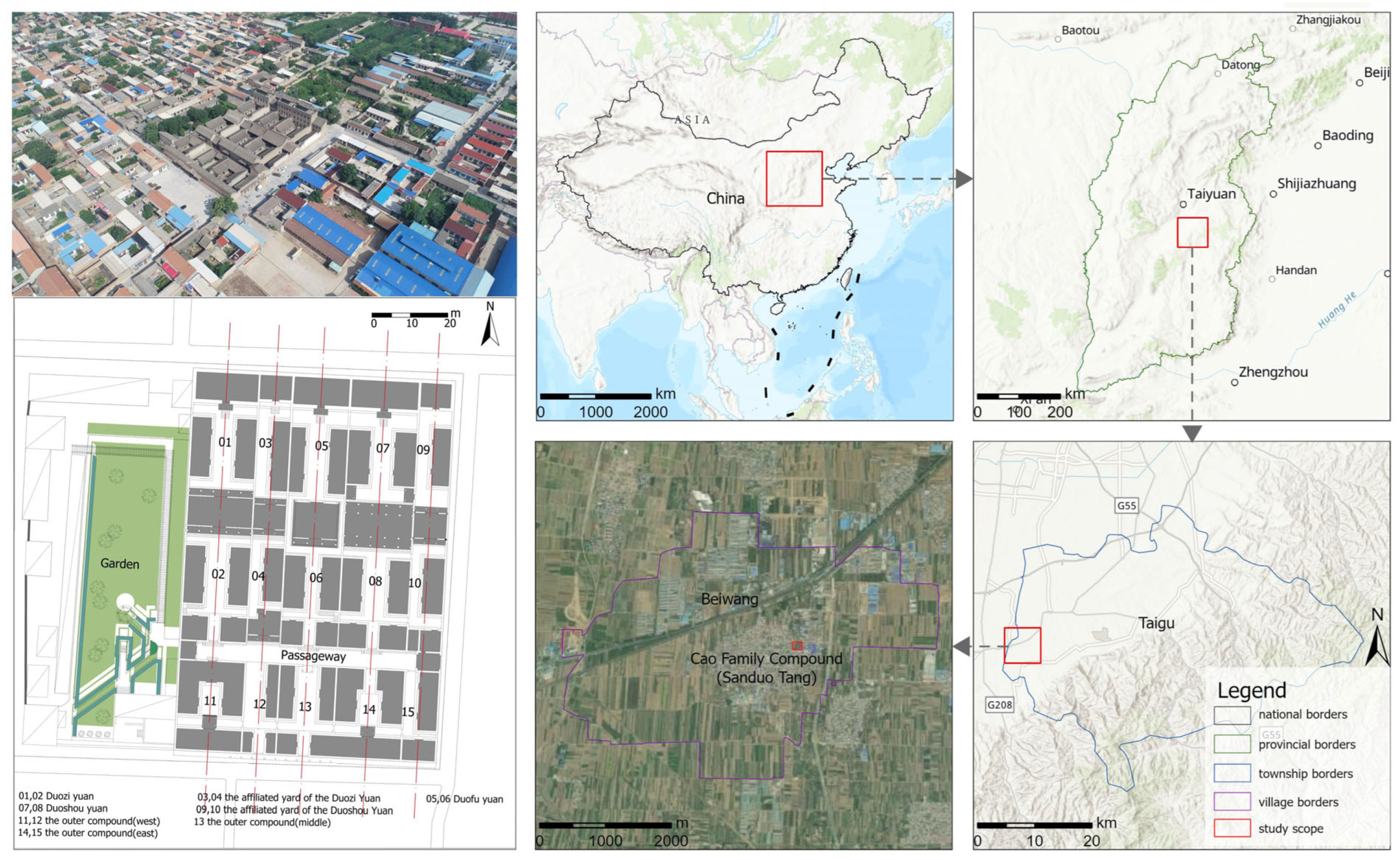
Figure 1. Map of the study area locations. (Data sources: Esri; TomTom; Garmin; Food and Agriculture Organization of the United Nations (FAO); National Oceanic and Atmospheric Administration (NOAA); United States Geological Survey (USGS).).
Buildings 15 03652 g001
Figure 2. Historical development of the Cao Family.
Buildings 15 03652 g002
Figure 3. The 38 tangible heritage elements and legal protection zone. (Note: See Table 1 for numbering details.).
Buildings 15 03652 g003
Figure 4. Methods and framework of the research.
Buildings 15 03652 g004
Figure 5. The historical imagery and architectural drawing of Beiwang Village. (a) Date 1945. (Source: https://www.archives.gov/) (accessed on 6 June 2018); (b) Date 1972. (Source: https://www.usgs.gov/) (accessed on 21 July 2020); (c) Memory-based architectural drawing (Source: provided by Cao Shiyu). (Note: The red box in (a,b) represents the Cao Family Compound).
Buildings 15 03652 g005
Figure 6. Buffer zone of Cao Family Compound. (Note: See Table 1 for numbering details.).
Buildings 15 03652 g006
Figure 7. Hongji Bridge in the context of cultural association.
Buildings 15 03652 g007
Table 1. Spatial elements culturally associated with the Cao Family Compound.
CategoriesContentsData Sources
1) historic residential compounds1-1) Wugui Tang; 1-2) Ningfu Tang; 1-3) Yonghuai Tang; 1-4) Cao Ancestral Hall; 1-5) Qiyuan Tang; 1-6) Chunfan Tang; 1-7) Weiqing Tang; 1-8) Yizheng Tang; 1-9) Qingyi Tang; 1-10) Deshen Tang; 1-11) Shuanghe Tang; 1-12) Dungu Tang; 1-13) Fushan Tang; 1-14) Huaiyi Tang; 1-15) Xiaoyou Tang; 1-16) Shihe Tang; 1-17) Baozhen Tang; 1-18) Yanling Tangfield investigation
historical imagery
architectural drawing
literature reviews
2) historic stores2-1) Hemp Shop; 2) Yunshengtang Pharmacy; 3) Sanlongtang Pharmacy; 4) Yusheng Tang Pharmacy; 5) Jinshoutang Pharmacy; 6) Yongjixuan Pharmacy; 7) Yushengtang Pharmacy; 2-8) Dingyi Wine Shop; 2-9) Yiji Pawnshop; 10) Fufeng Pawnshop; 11) Xiao Ya Pawnshop; 12) “Shi” Hostel; 2-13) Liudegong Management Organizationsliterature review
3) religious buildings3-1) Guandi Temple; 3-2) Sanguan Temple; 3-3) Dasi Temple; 3-4) Guanyin Temple; 3-5) Baizi Cave;3-6) Miaojue Temple; 3-7) Tangdi Templeoral history interview
architectural drawing
4) historic streets and alleys4-1) Double Doors; 4-2) East Back Street; 4-3) West Back Street; 4-4) Pailou Street; 4-5) Guandi Temple Street; 4-6) Siyuan Road; 4-7) Shafang Street (Xinglong Street); 4-8) Xinglong East Street; 4-9) Minibus Roadfield investigation
historical imagery
architectural drawing
literature review
Table 2. Evaluation system for spatial elements.
CriteriaInterpretationsExamples
A. historic residential compoundstangible
dimensions
residential courtyards and related dwellings of the Cao FamilyYanling Tang; Wugui Tang
B. historic storescommercial establishments founded by the Cao FamilyDingyi Wine Shop; Yushengtang Pharmacy
C. religious buildingsreligious structures in the vicinity of the Cao Family residencesSanguan Temple; Dasi Temple
D. historic streets and alleyshistoric roads and streets surrounding the Cao Family Pailou Street; East Back Street
E. traditional customsintangible dimensionsmarriage, funeral, and sacrificial rituals of the Cao FamilyCao Kerang’s arranged marriage for his daughter
F. significant eventssocial events and historical incidents involving the Cao FamilyCao Runtang’s initiative in the restoration of the Guandi Temple
Table 3. Weights and scoring rules.
CriteriaWeightsClassificationsScores
A. historic residential compoundstangible dimensions0.2901well-preserved100
generally preserved70
poorly preserved40
disappeared10
B. historic stores0.16105well-preserved100
generally preserved 70
poorly preserved40
disappeared10
C. religious buildings0.0502well-preserved100
generally preserved 60
poorly preserved40
disappeared10
D. historic streets and alleys0.10295yes100
no0
E. traditional customsintangible dimensions0.148383 occurrences100
2 occurrences66
1 occurrence33
no occurrences0
F. significant events0.247327-8 social events occurred100
5-6 social events occurred75
3-4 social events occurred50
1-2 social events occurred25
No social events occurred0
Disclaimer/Publisher’s Note: The statements, opinions and data contained in all publications are solely those of the individual author(s) and contributor(s) and not of MDPI and/or the editor(s). MDPI and/or the editor(s) disclaim responsibility for any injury to people or property resulting from any ideas, methods, instructions or products referred to in the content.