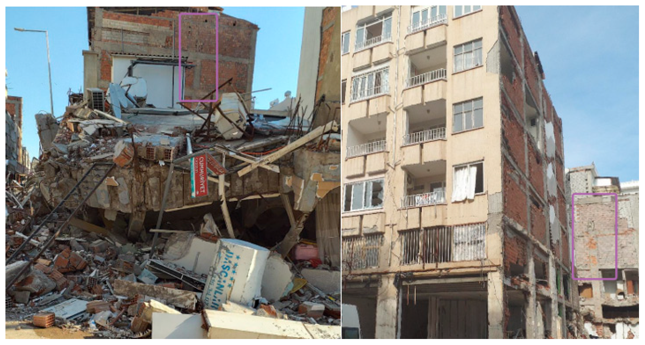
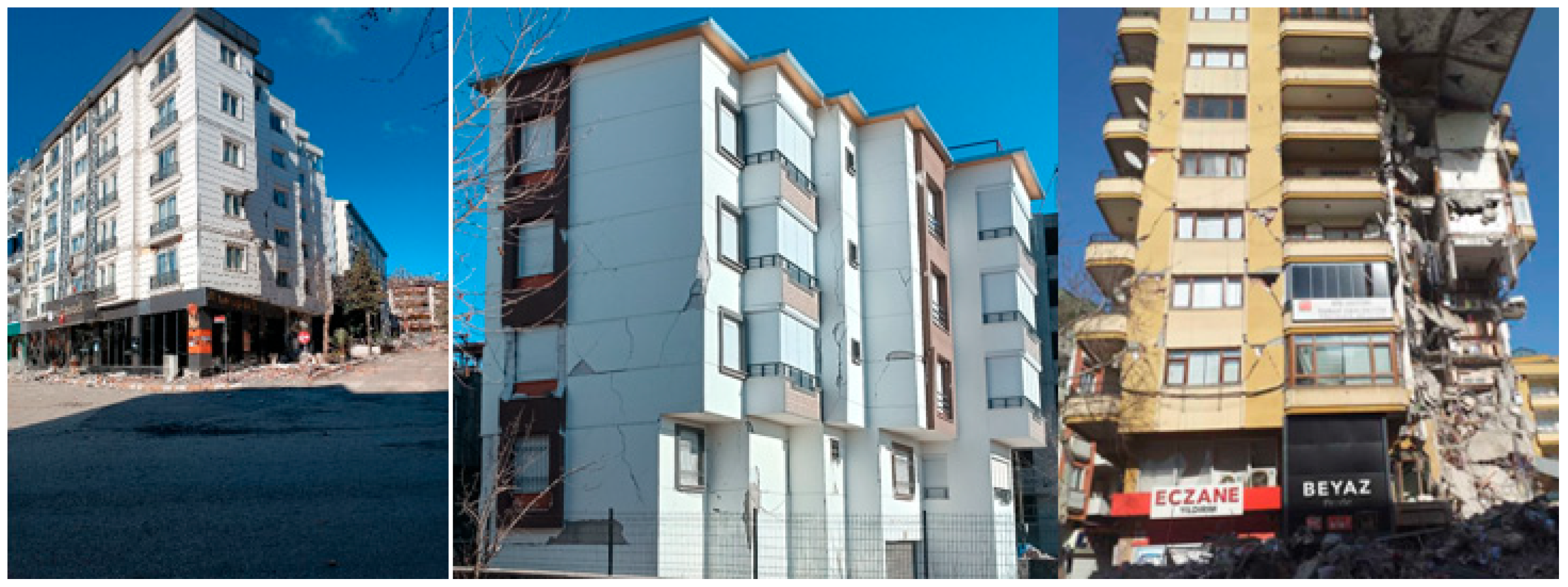
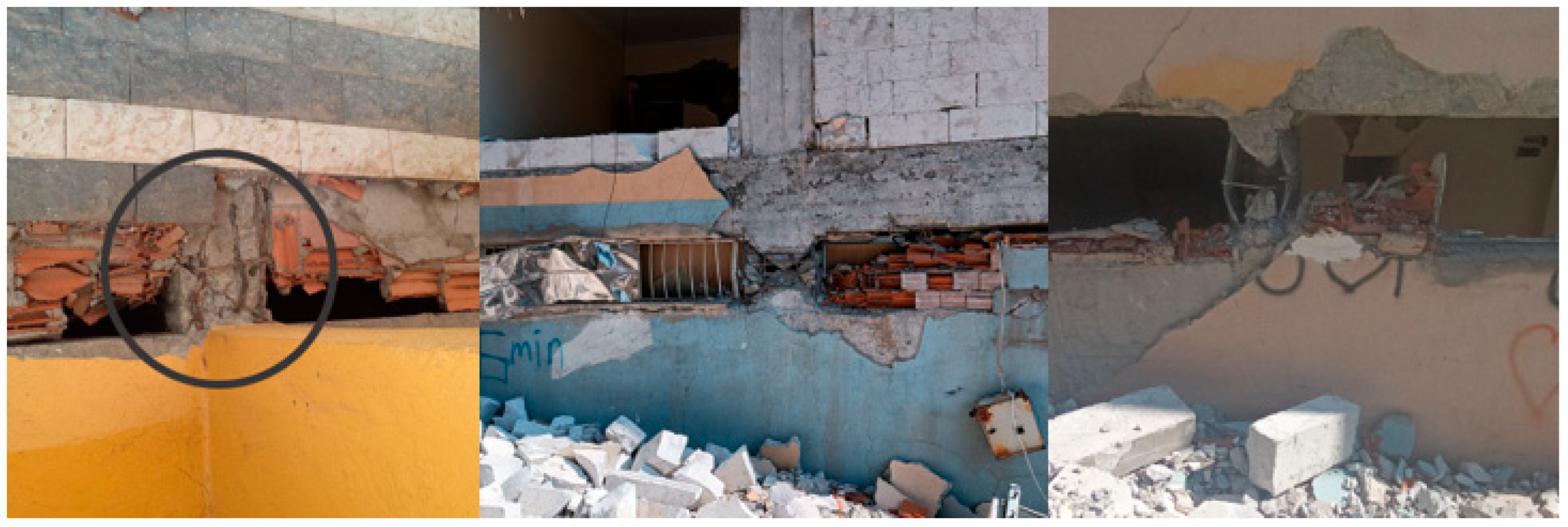
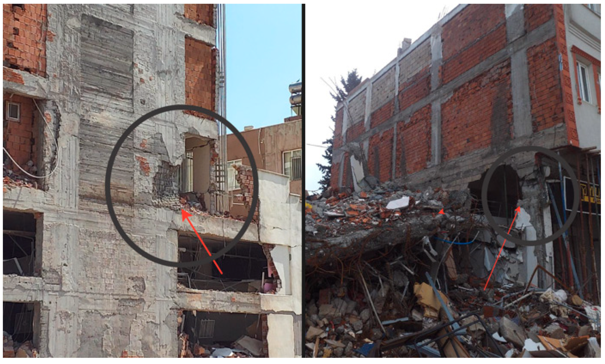
1. Introduction
Earthquakes are unpredictable and destructive, affecting infrastructure and populations. The uncertainties regarding when, where, and to what extent earthquakes will occur highlight the importance of structural resilience and underscore the need for preventive measures. Possible damage can be minimized by applying earthquake-resistant design principles to newly constructed buildings and by retrofitting existing structures to increase their seismic performance. Decisions regarding demolition and retrofitting, based on detailed seismic performance analyses of the existing building stock, are crucial to reducing the impact of potential earthquakes. Earthquake damages in regions with high seismic risk, such as Türkiye, state that the seismic performance of buildings is not at the expected level. Thus, analyzing the existing building inventories can be a vital tool for decision-making processes in regions prone to frequent seismic activity [
1,
2,
3,
4,
5,
6,
7]. However, the the vast number of existing buildings complicates the process of conducting detailed seismic performance analyses. Risk prioritization among buildings and the establishment of a ranking system for detailed examination can help streamline the process. For this purpose, rapid seismic assessment methods have been globally developed to determine the risk priorities among structures [
8,
9,
10,
11,
12,
13]. These rapid assessment techniques, tailored for various structural systems, aid in identifying risk priorities among existing buildings [
14,
15,
16,
17]. Since detailed examination of all buildings is labor intensive and time consuming, practical methods are essential for evaluating their earthquake resilience [
18,
19,
20,
21,
22,
23,
24,
25].
Rapid visual screening (RVS) approaches have become essential tools for prioritizing the seismic risk of large urban building stocks. The need for rapid, reliable, and computationally easy-to-use methods for assessing existing building stock was the first recognized in the USA in 1988, when the Federal Emergency Management Agency (FEMA) published a handbook titled “
Rapid Visual Screening of Buildings for Potential Seismic Hazards.” This handbook was updated in 2002 and 2015, enriched by scientific advances and seismological experience, and finally published as FEMA P-154. The FEMA approach, which takes into account local materials, construction techniques, and design philosophies, has been adopted by many countries, leading to the development of various rapid assessment methods [
26,
27,
28,
29]. There are many studies across various regions of the world using rapid assessment approaches proposed for various structural system types. In addition to providing valuable information to understand the current status of the existing building stocks, these studies also form a basis for developing solution proposals. Bošković et al. [
30] compared rapid assessment methods with structural analysis results for masonry and RC buildings in Serbia and evaluated the usability of these methods. Ereš et al. [
31] attempted to ascertain to determine the seismic risk ranks for city blocks in Croatia (Osijek). Dolce et al. [
32] carried out research to ascertain the seismic risks of selected buildings in Italy. Shendkar et al. [
33] made recommendations for existing RC structures using the rapid assessment method in India (Koyna-Warna). Ademovic et al. [
34,
35] conducted seismic risk analyses of the current Bosnia and Herzegovina, building stock. Kassem et al. [
36] examined existing structures in Malaysia using the web-based rapid assessment method.
Various rapid assessment methods have been developed in Türkiye, and examples of their implementation have been published in the literature. It was first legally specified in 2013 and later amended by the Turkish Building Earthquake Code (TBEC-2018). There are studies in the literature that use rapid assessment methods similar to these studies in settlements in different geographical regions of Türkiye. Başgöze and Güncü [
37] aimed to identify regional risk priorities by using the quick evaluation technique developed by METU for 490 R/C structures in Erzincan province, a city with a very high earthquake risk, within the scope of their study. Büyüksaraç et al. [
38] attempted to assess risk priorities among districts by obtaining structural result scores for each district for the currently used Turkish rapid assessment method, as well as the seismic risks of Van province and its districts. Aynur and Atalay [
39] determined risk priorities by comparatively examining different rapid assessment methods for structures located in the Yalova/Çınarcık that exposed different levels of earthquake damage. Nemutlu et al. [
40] carried out a rapid assessment process for 1261 buildings in Bingöl. İnel et al. [
41] made a detailed evaluation of the existing building stock of 3466 units in Denizli province.
In this research, the 2019-Turkish Rapid Assessment approach was used for the existing RC building stock in the Bitlis province centre situated within the Lake Van Basin, a region characterized by high seismic risk. Different structural systems and methods were used in studies where rapid assessment methods were examined specifically for Bitlis province. Bülbül et al. [
42] sought to determine the risk prioritization of 329 RC buildings in Bitlis province through the use of genetic algorithm and artificial neural networks together. They used the 2013-Turkish Rapid Assessment Method in their study. Arkan et al. [
43] tried to determine the risk priorities for traditional masonry structures in Bitlis province in their study. Işık [
44] aimed to identify the risk priorities by using the rapid evaluation approach developed by METU for the existing RC structure inventory. Işık and Kutanis [
45] evaluated the existing RC building stock in Bitlis province using the P25 method. These studies enable rapid, systematic, and comparable analysis of the building stock at risk from earthquakes, providing a rich data source for areas such as the creation of regional seismic risk maps, the development of risk prioritization algorithms, and the testing of theoretical models related to building safety. From an applied perspective, they enable the prioritization of buildings before commissioning engineering services, particularly in resource-limited regions. They provide a scientific basis for local governments’ urban transformation, disaster management, and retrofitting policies, and provide an effective tool for determining intervention priorities. In this respect, rapid assessment methods both support scientific research and contribute to the implementation of disaster-resilient urbanization policies.
Located in a strategically important area of the Eastern Anatolia Region, Bitlis lies among the most active seismic and high-hazard region in Türkiye. Among the regions within this zone, Bitlis province, situated in the high-seismic-risk Lake Van Basin, stands out as a critical area for investigation. Owing to its location within this basin, Bitlis and its districts are particularly susceptible to the impacts of potential earthquakes affecting both the basin and the wider region. This study focuses on risk prioritization for a hundred RC buildings in the Bitlis city centre, using the 2019 Turkish Rapid Assessment methodology. The selected RC buildings, ranging from 1 to 7 stories, were chosen from various sub-districts across the city centre. Field observations were conducted to gather relevant building data, which were subsequently combined with additional data in an office setting. Based on these inputs, structural system scores for each building were calculated. The negative parameters identified for the evaluated buildings were classified, and general information regarding the building stock in the studied region was provided. In the context of the Principles for Determination of Risky Buildings (PDRB-2019) [
46] rapid assessment methodology, “negative parameters” refer to specific structural vulnerabilities or irregularities, such as soft/weak story, plan irregularity, short column, visual quality, and position of the building that are known to adversely affect a building’s seismic performance. These parameters are visually identified and are used to deduct points from a building’s base performance score to assess its relative risk. The study represents the first attempt at regional risk prioritization for existing RC structures in Bitlis province, in accordance with PDRB-2019. Furthermore, this study separately examines rapid assessment parameters in light of the recent 2023-Kahramanmaraş earthquakes. Structural damage caused by these earthquakes is discussed, with details provided for each identified negative scenario.
The METU method determines a base score by selecting a hazard zone based on peak ground velocity (PGV). From this base score, deductions are applied for seven different parameters, including number of stories, presence of soft or weak stories, heavy overhangs, apparent building quality, short columns, pounding effects, and topographic impact, to obtain the final score. In contrast, the 2013 Turkish Rapid Assessment method establishes the base score primarily according to the earthquake zone, offering a more simplified but less site-specific approach. Building upon these earlier approaches, PDRB-2019 systematically integrates site-specific seismic hazard parameters into the scoring process, thereby providing a more detailed and context-sensitive assessment. The negative parameters considered in the last two legally used Turkish Rapid Assessment methods are the same.
However, the latest guideline, PDRB-2019, represents a significant advance by incorporating seismic hazard parameters, particularly design spectral acceleration (SDS), into the scoring system and standardizing the set of negative structural parameters for reinforced concrete buildings. This constitutes a critical improvement by establishing a uniform framework at the national level for risk prioritization. Therefore, this study is necessary to demonstrate the practical results of applying PDRB-2019 in a real urban context and to provide insights into its performance compared to previous, less code-consistent methods.
To this end, the present research applies PDRB-2019 in the city centre of Bitlis, providing a concrete case study that illustrates the method’s applicability and effectiveness in a high-seismic-risk but under-researched area. It provides the first quantitative assessment of the seismic performance of the existing reinforced concrete building stock in the area. By prioritizing risks based on the number of stories, structural system characteristics, types of irregularities, and other observed vulnerabilities, the study generates original field data to guide local disaster risk management and urban transformation policies.
Moreover, by examining the relationship between structural damage observed during the 2023 Kahramanmaraş earthquakes and the parameters considered in the PDRB-2019 framework, the study empirically demonstrates the significance of these parameters under real field conditions. Thus, it serves as a notable example of the field application of PDRB-2019 and provides a valuable reference for regions with similar seismic profiles. In short, this research validates the regional applicability of PDRB-2019, demonstrates its practical effectiveness, and offers empirical justification for its use. By addressing a critical gap in the implementation of Türkiye’s most current rapid visual screening guide, it provides a regional case study supporting disaster risk reduction, policy implementation, and future seismic resilience planning.
3. Principles for Turkish Rapid Assessment Method-2019
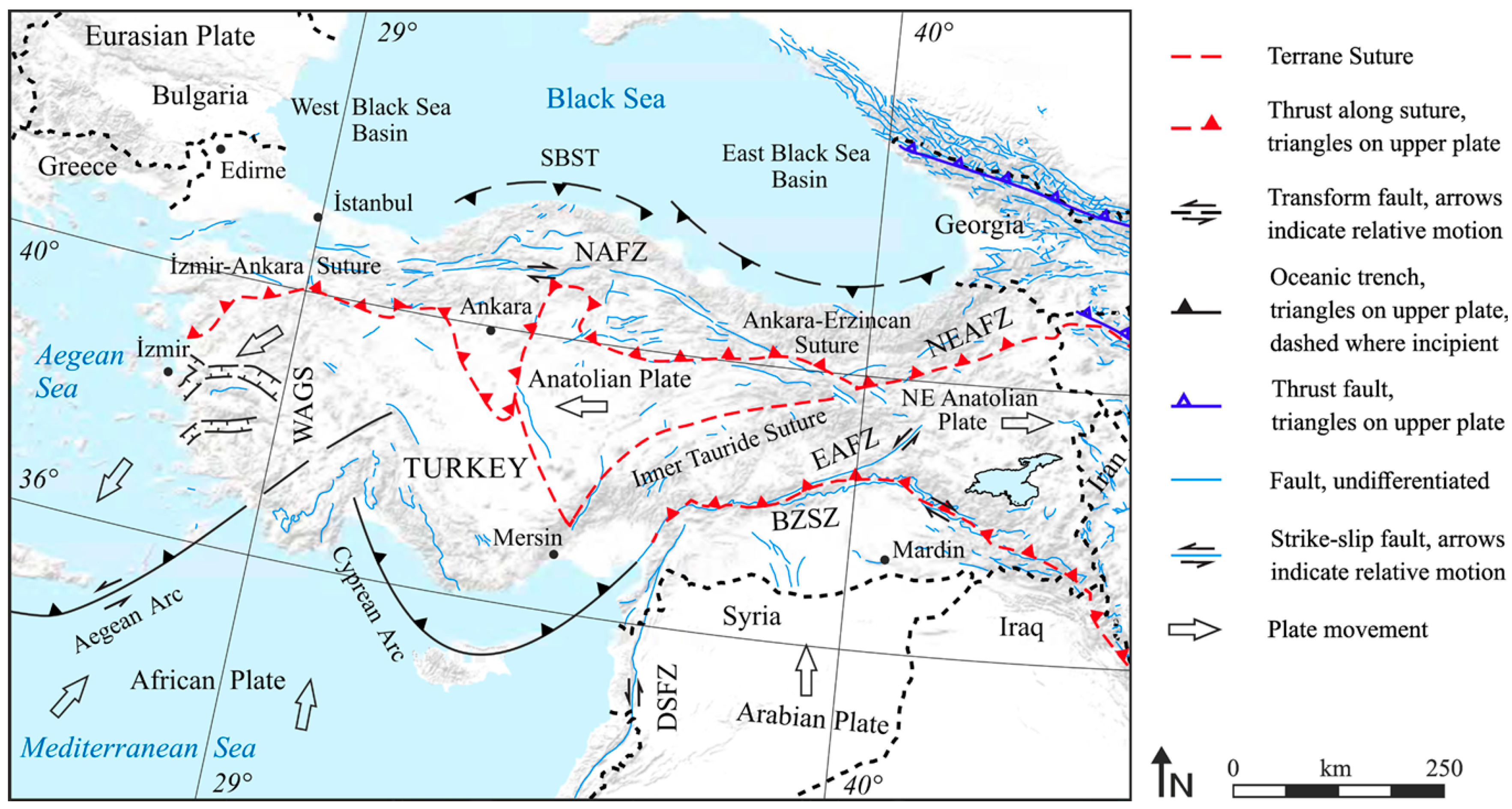
Earthquakes in Türkiye are recognized for causing substantial damage to RC structures, along with significant loss of life and property. Notable seismic events, including the 1992 Erzincan, 1995 Dinar, 1998 Adana/Ceyhan, 1999 Kocaeli, 1999 Düzce, 2003 Bingöl, 2011 Van, 2020 Elazığ, 2020 İzmir, and the 2023 Kahramanmaraş earthquakes, have repeatedly demonstrated that the nation’s existing building stock lacks sufficient earthquake resistance. Over time, Türkiye has experienced numerous large and destructive earthquakes, with the most recent occurring on 6 February 2023, in Kahramanmaraş, resulting in approximately 53,000 casualties. This devastating event has once again highlighted the pressing reality of Türkiye’s vulnerability to seismic hazards [
62,
63,
64,
65,
66,
67,
68,
69,
70]. In light of these events, there is an urgent need to assess the resilience of the existing building stock and implement the necessary measures to mitigate the impact of future earthquakes in the region.
The vast number of existing buildings in Türkiye presents significant challenges in conducting detailed earthquake performance assessments as required by seismic design code within a limited timeframe. Given the scale of the existing building stock, it is not feasible to determine the seismic performance of all structures due to constraints on public resources and economic considerations. In response to these challenges, rapid assessment processes have been created to facilitate the quick evaluation of structures and prioritize those at higher risk. This approach significantly reduces the number of buildings that need in-depth structural evaluation [
71,
72,
73,
74,
75,
76,
77,
78]. The adequacy of a building’s earthquake performance should be determined through detailed analyses and evaluations conducted in accordance with the principles outlined in Chapter 15 of the Turkish Building Earthquake Code (TBEC-2018) [
79]. This study utilizes the assessment method outlined in the section titled
Methods That Can Be Used to Determine the Regional Risk Distribution of Buildings within Law No. 6306 on the
Transformation of Areas Under Disaster Risk, which was updated in 2018 to incorporate the earthquake hazard map and related regulations (PDRB-2019) [
51]. The method specifies the parameters to be considered and the calculation process for structural result scores for different types of buildings. This approach is applied to existing RC buildings with 1–7 stories. The parameters required for this assessment are outlined as follows. The design spectral acceleration coefficient (S
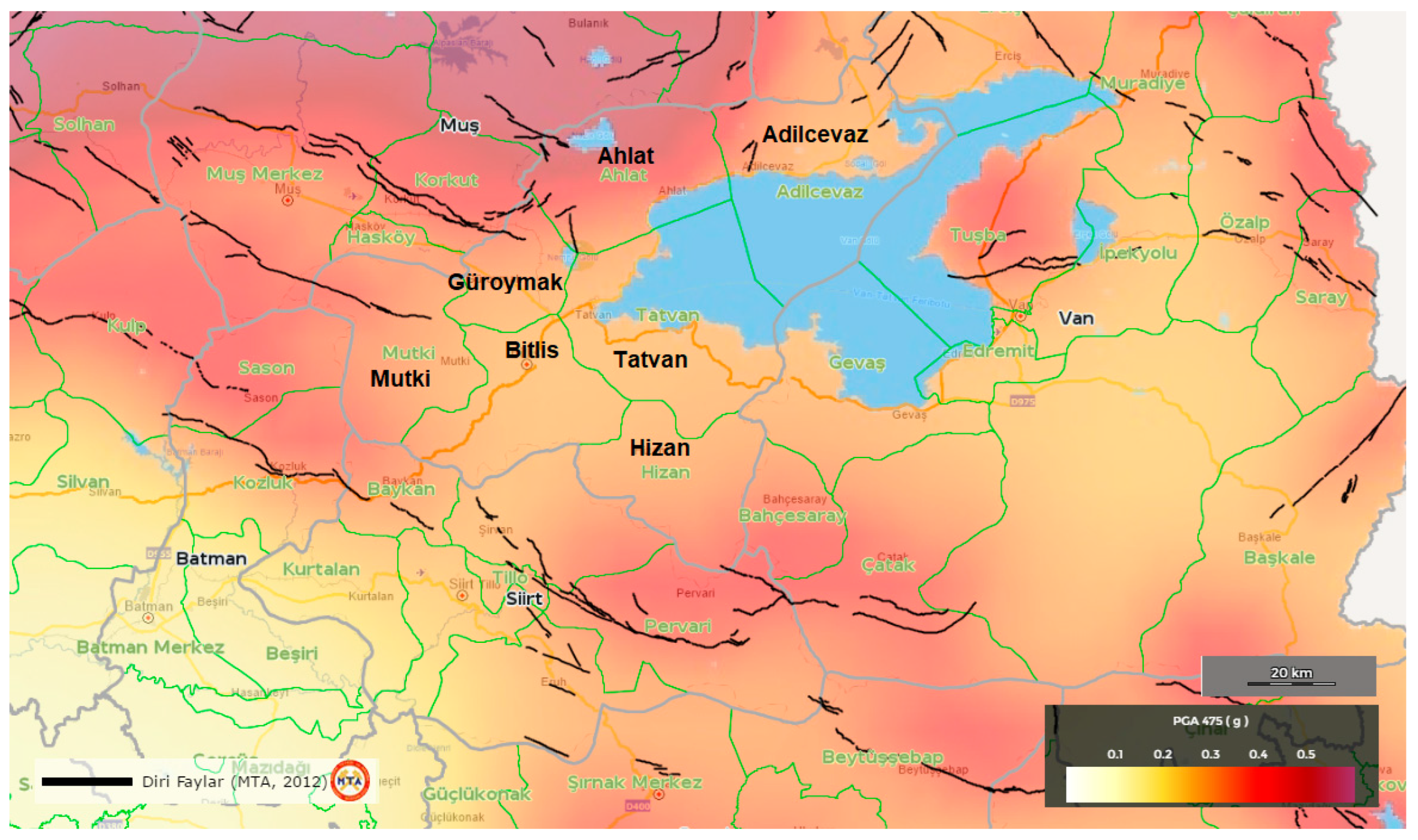
DS) is determined using the Türkiye Earthquake Hazard Map, based on the level of earthquake ground motion. In this method, the rare earthquake ground motion (DD-2) is considered, with a 10% probability of exceedance in 50 years, corresponding to a repetition period of 475 years. The earthquake hazard zone is determined based on the S
DS obtained. The classification of earthquake hazard zones using this technique is provided in
Table 1.
The base score is to be derived by incorporating the total number of stories together with the structural system of the building for the geographical location where the earthquake hazard location is determined.
Table 2 displays the base score values established by considering the hazard zone, story number, and type of structural system.
After these values are determined, some negativity parameters will be needed. These negativity parameters are obtained directly from the officially published PDRB-2019, which is based on empirical observations and lessons learned from past earthquakes in Türkiye. These parameters were determined through extensive research and field data, and are standardized by national authorities to ensure consistency and reliability in rapid seismic risk assessments. The negativity parameters taken into consideration are detailed below. These parameters are as follows:
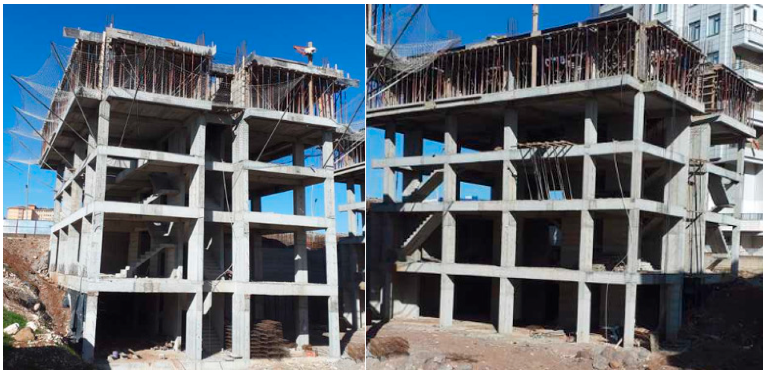
Structural system type: The structural system of the building will be determined and categorized as either an RC frame (RCF) or an RC frame with shear walls (RCF + RC shear walls). Some examples for RCFs are shown in
Figure 3.
If there is a basement, it will be appropriate to detect the structural system type from inside the basement. If the structural system cannot be observed, it will be suitable to select the RCF. The structural system selection is shown in
Figure 4.
Number of stories: The number of free stories (
) will be determined by taking into account
Figure 5.
Figure 5.
Determination of the number of stories (nsk) in RC buildings.
Figure 5.
Determination of the number of stories (nsk) in RC buildings.
Building visual quality: The observable quality of a building reflects the attention paid to material quality, workmanship, and maintenance. The building’s visual quality is categorized as good, medium, or poor.
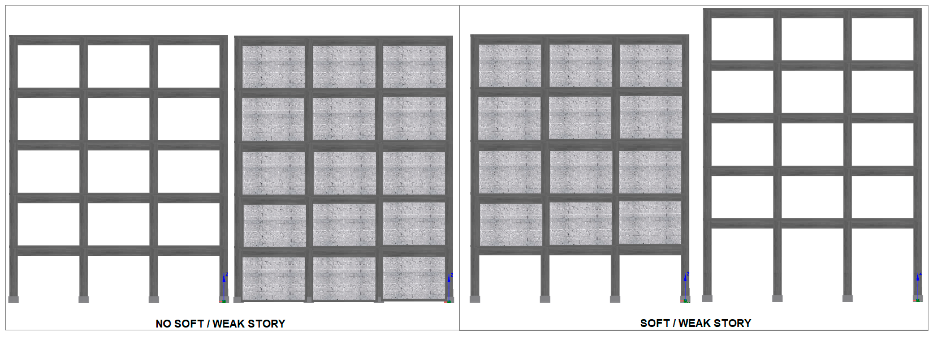
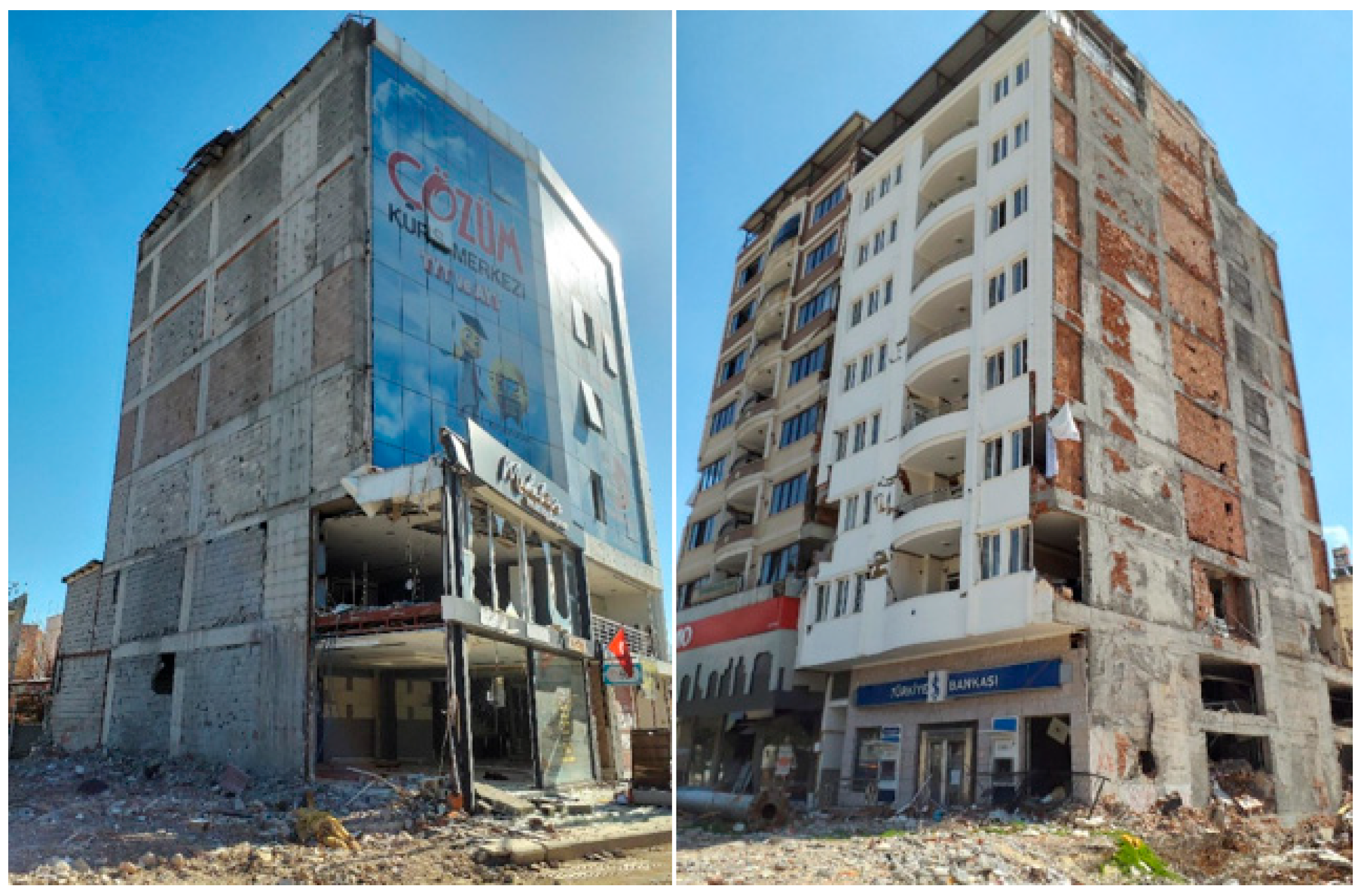
Weak/Soft Story: It will be determined through observation, taking into account both the variation in story height and the apparent differences in inter-story rigidity. The determination of the soft/weak story status is seen in
Figure 6.
Figure 6.
Detection of soft/weak story.
Figure 6.
Detection of soft/weak story.
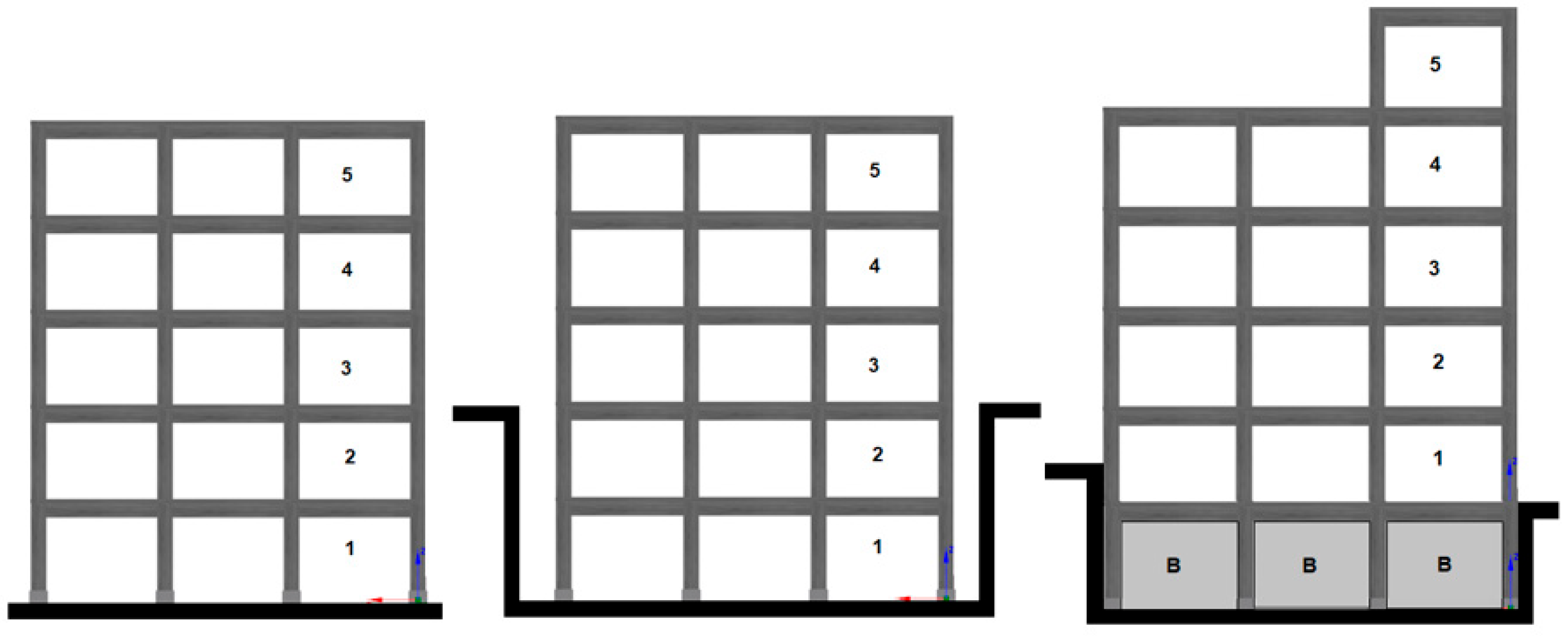
Vertical irregularity: The assessment will consider the impact of frames that are discontinuous vertically and variations in floor areas. Columns or RC shear walls that do not extend through the full height of the building introduce vertical irregularities. The procedure for determining vertical irregularity is illustrated in
Figure 7.
Figure 7.
Samples for irregularity in vertical.
Figure 7.
Samples for irregularity in vertical.
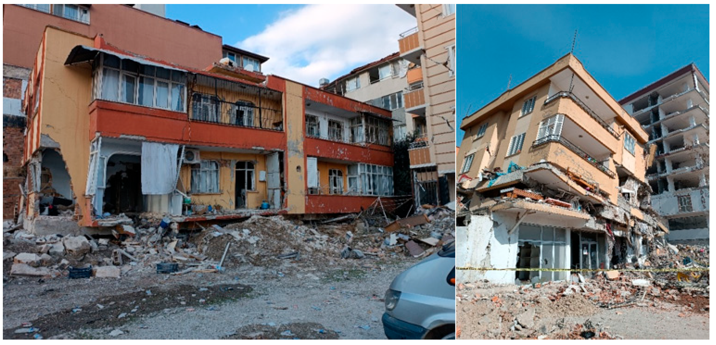
Heavy overhangs: The variation between the ground floor area and the areas of the upper stories will be determined, with the determination of substantial overhangs presented in
Figure 8.
Figure 8.
Detection of heavy overhangs in RC structures.
Figure 8.
Detection of heavy overhangs in RC structures.
Irregularity in plan/Torsion effect: Plan irregularity is defined as the geometric asymmetry of the building plan and the irregular arrangement of vertical structural elements. Such irregularities, which may induce torsion in the structure, will be considered. The procedure for determining plan irregularity is illustrated in
Figure 9.
Figure 9.
Determination of irregularities in the plan of RC buildings.
Figure 9.
Determination of irregularities in the plan of RC buildings.
Short column effect: For this phase, only the short columns apparent from the building exterior will be considered. The condition with the short column is the determination as shown in
Figure 10.
Figure 10.
Short column situation in RC structures.
Figure 10.
Short column situation in RC structures.
Position of the Building/Floor levels with adjacent buildings: The pounding effect arising from nearby buildings can significantly affect seismic performance. Buildings situated at the edge are particularly vulnerable, and discrepancies in floor levels with adjacent structures amplify this vulnerability. The occurrence of pounding will be determined by visual observation, considering both building position and floor level relationships.
Figure 11 illustrates the determination procedure. The determination of the floor levels with adjacent buildings is shown in
Figure 12.
Figure 11.
The position of adjacent buildings (a) isolated, (b) middle, (c) corner, (d) corner.
Figure 11.
The position of adjacent buildings (a) isolated, (b) middle, (c) corner, (d) corner.
Figure 12.
Determination of floor level changes in adjacent buildings.
Figure 12.
Determination of floor level changes in adjacent buildings.
Hill/Slope Effect: Buildings will take this effect into consideration where constructed on hills over a specific incline. If the slope of the natural ground is below 30°, the hill/slope effect will be considered as No, if the slope of the natural ground is above 30°, the hill/slope effect will be considered as Yes.
Earthquake hazard zones: The evaluation will follow the prescribed earthquake ground motion levels and soil class definitions, as indicated in
Table 1.
Geographic coordinates: It is to be determined following the coordinate reference system used in the Türkiye Earthquake Hazard Map.
Each building’s performance score will be determined by evaluating the collected data. The DD-2 earthquake ground motion level will be used, with SDS values obtained from the latest Türkiye Earthquake Hazard Map. Earthquake hazard zones, provided in
Table 1, will be established based on the relationship between parameter values and local soil types. The structural system type will contribute positively to the performance score. The RCF buildings system will not receive any extra scores, and Structural System Score (
YSP) will be given using
Table 3 for buildings with other structural systems (RC + RC shear walls). For all negativity parameters other than visual quality and position of the building, determinations will be made as Present or Not Present (
Table 3). The negativity values of the parameters that relate to these outcomes (
Oi) are interpreted as 1 and 0 for Present and Not Present states. If the visual quality assessment is Good, the negativity parameter value (
Oi) will be taken as 0, if it is Medium, as 1 and if it is Bad, as 2. If the position of the building is isolated, the negativity parameter value (
Oi) will be taken as 0, if it is Adjacent/Adjacent in the Corner, as 1. One score will be taken into account for each negativity parameter. These scores are shown in
Table 4.
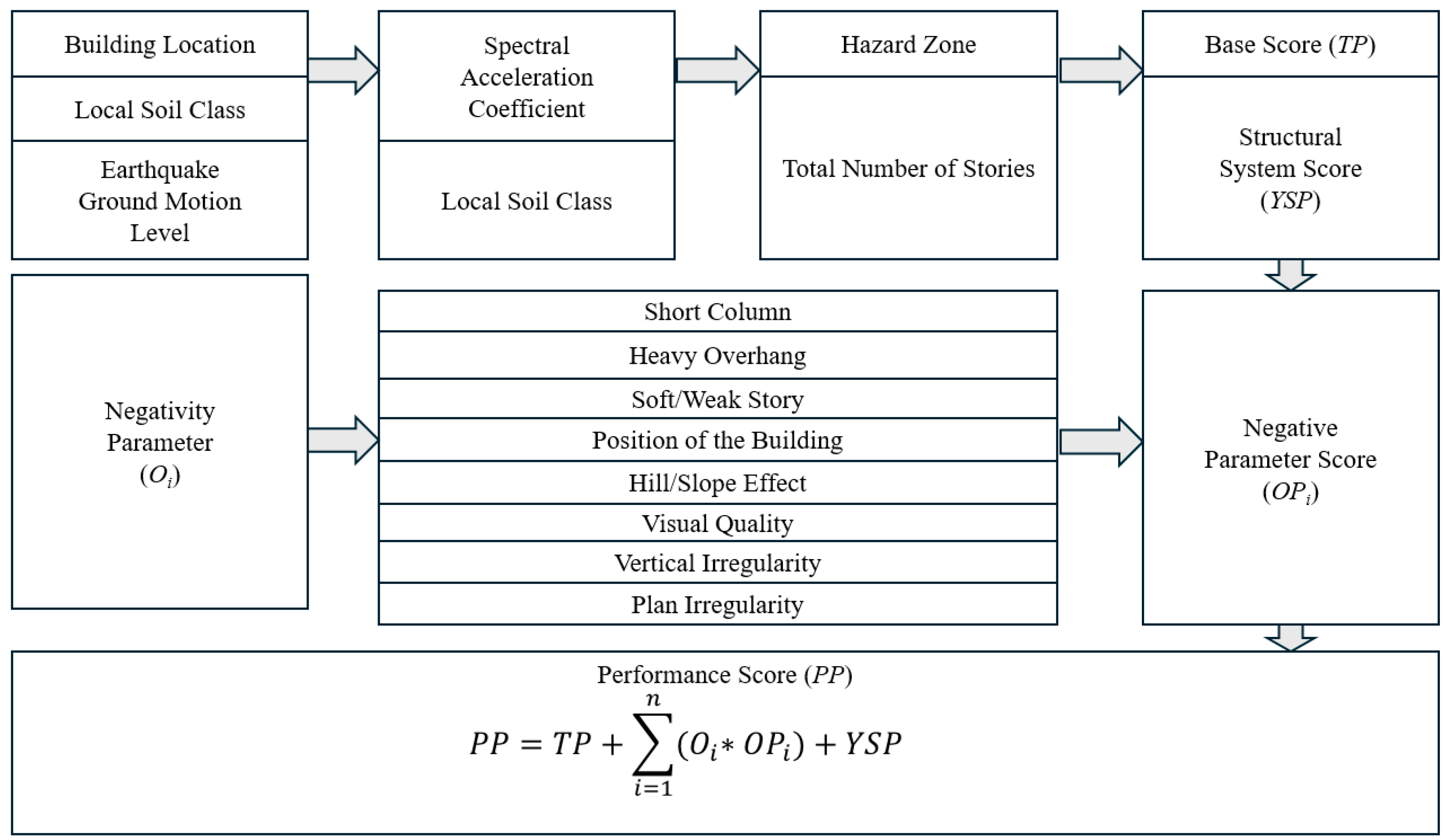
With all the result values obtained, the building performance score will be determined with the formula given below.
In this context,
PP denotes the performance score,
TP represents the base score,
Oi refers to each individual negativity parameter,
OPi represents the score for each negativity parameter, and
YSP indicates the positive parameter score, which corresponds to the structural system score. The impact of the structural system type is accounted for as a positive score. The structural system score (
YSP) is a parameter that reflects the influence of the building’s structural system on its seismic performance. In this process, a base score is established, and reductions are made based on each identified negativity parameter. It is particularly effective in determining regional risk priorities for RC and masonry structures, allowing for the prioritization of buildings that require detailed structural analysis. The flowchart of this method for RC buildings was given in
Figure 13.
5. Rapid Survey in Bitlis and Outcomes
This study encompasses the assessment of 100 existing reinforced-concrete buildings from ten different sub-districts in the central district of Bitlis which were considered and risk prioritization was made among these buildings. Ten buildings were selected from each sub-district. These sub-districts are Hüsrevpaşa, Beş Minare, Taş, İnönü, Şemsi Bitlis, Gazibey, Atatürk, 8 Agustos, 160 Evler, and Hersan. In the building selection, structures constructed before the current seismic design code (TBEC-2018) [
79] were taken into account. As a result of the site examinations, latitude and longitude belonging to the geographical locations of each RC structure were recorded. These geographical coordinates were entered as data into the Interactive Web Earthquake Application [
58] and these data were used to obtain the parameter values to be obtained in determining the earthquake risk priorities in the regions where the RC structures are located. Thus, there was an attempt to determine which structures were more prioritized in terms of risk. The comparison of the maximum ground acceleration (PGA) and maximum ground velocity (PGV) values for different earthquake ground motion levels for each of the locations for 100 existing RC structures using the Türkiye Earthquake Hazard Maps Interactive Web Application is shown in
Table 5.
The similarity of local soil conditions in all examined structures and the fact that the structures are located very close to each other caused the calculated seismic parameters to give very close results. When determining the local soil type, information regarding soils from relevant institutions and organizations was taken into account. In this context, the local soil type was accepted as ZD and the properties of this soil type are presented in detail in
Table 6.
The seismic parameters that were acquired using the interactive earthquake application are presented in
Table 7. These parameters are calculated depending on the local soil properties and earthquake hazard of the region where the structures are located and are of critical importance for evaluating the behaviour of the structures against earthquakes. The standard design ground motion level, DD-2, is taken into account when making these selections. DD-2 earthquake ground motion level describes an earthquake ground motion where the probability of exceedance spectral magnitudes in 50 years is 10% and the corresponding repetition period is 475 years.
Here, Fs and F1 represent the local soil coefficients used to modify spectral acceleration values based on local soil conditions. TA and TB refer to the corner periods of the horizontal elastic design spectrum, TAD and TBD are the corresponding corner periods for the vertical elastic design spectrum. Since the local soil type is the same in all structures, the local ground coefficients (Fs and F1) have taken values close to each other. This situation is also valid for the design spectral acceleration coefficients (SDS, SD1), and horizontal and vertical design spectrum corner periods (TA, TB, TAD, TBD). There may be significant differences between these values in distant settlements with different earthquake hazards.
Rapid Assessment Results
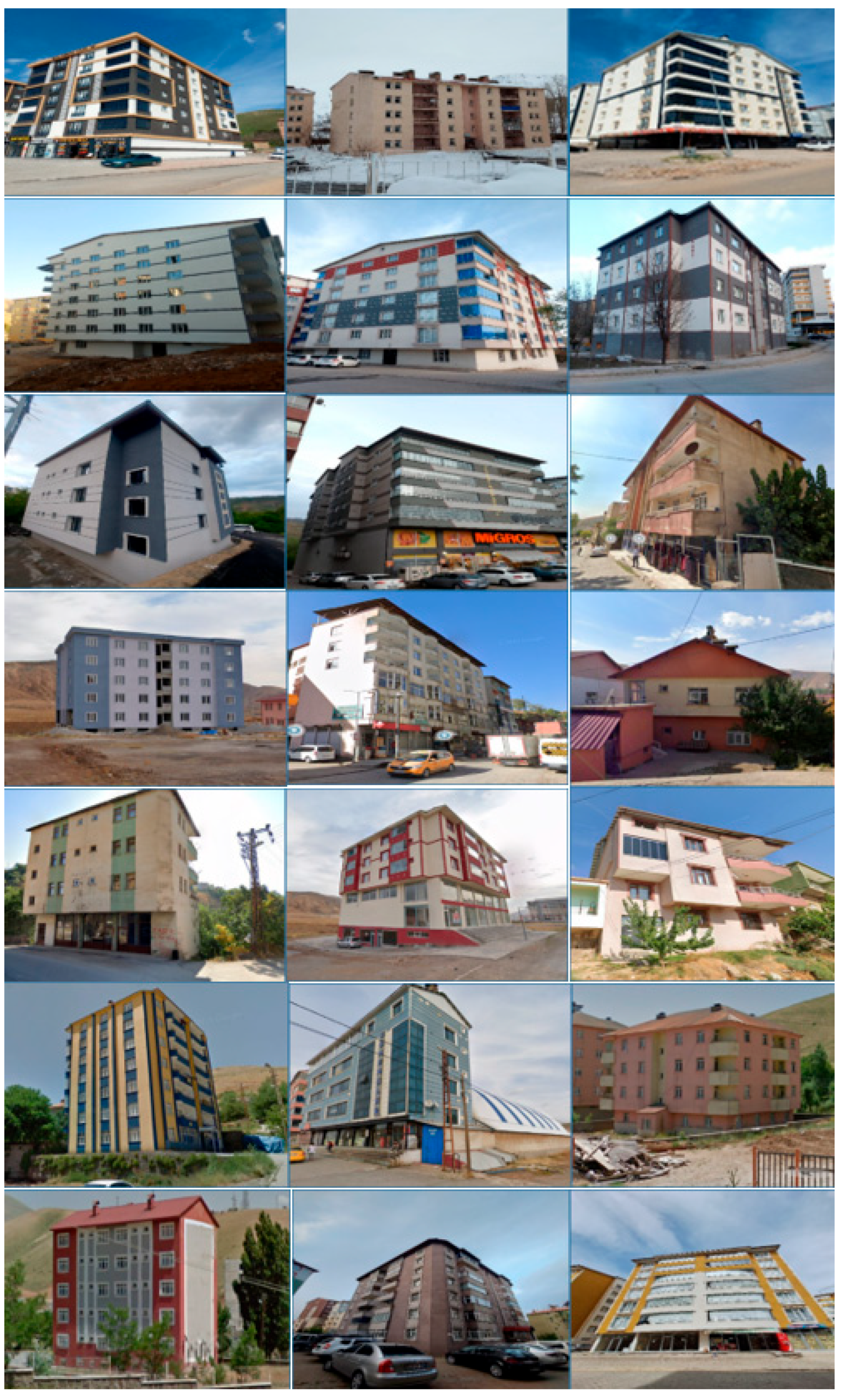
Some examples of existing RC buildings subjected to the rapid assessment process in the central district of Bitlis province are displayed in
Figure 25.
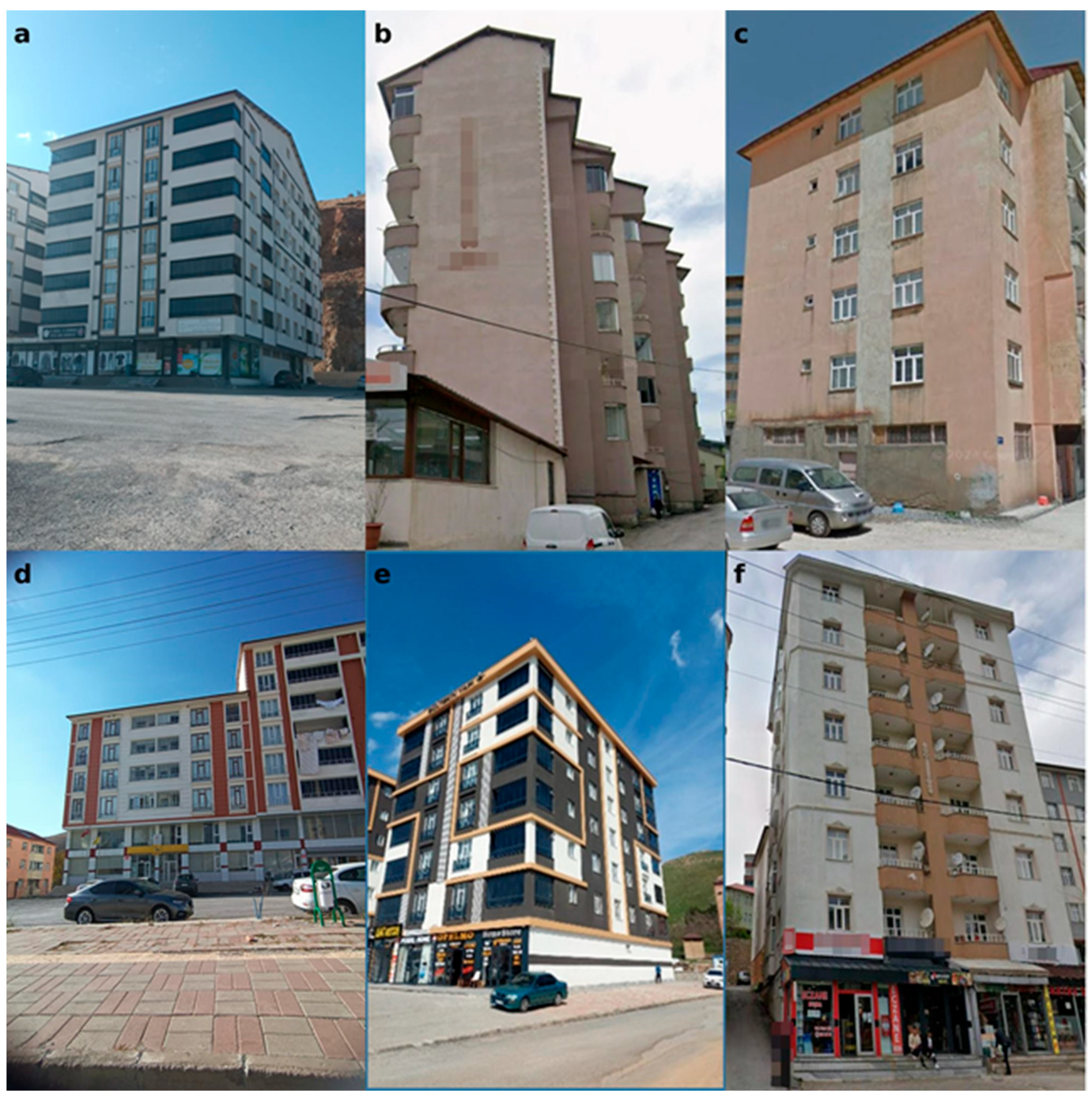
Examples of negative parameters considered in the rapid assessment of RC buildings within this study are shown for several buildings in Bitlis city centre in
Figure 26. While relatively soft/weak storey formation is shown in a, an example of plan irregularity is displayed in b, short column in c, adjacent building examples in d, isolated building example in e, and hill/slope effect example in f.
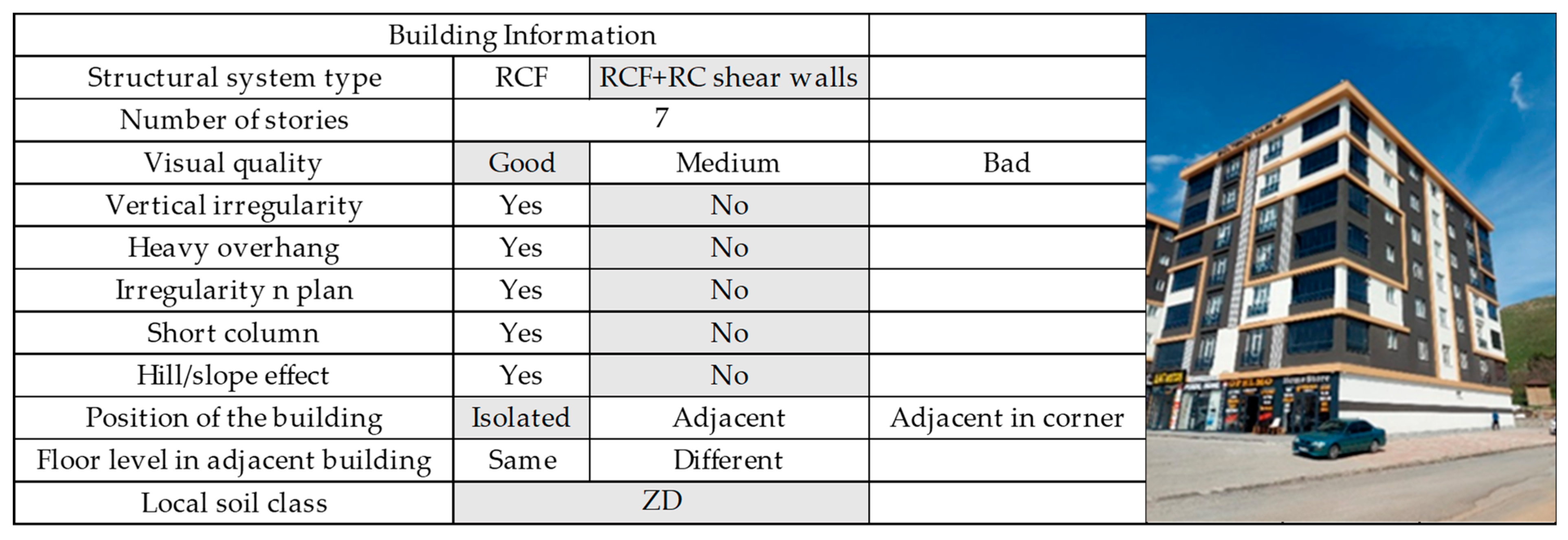
Structural system scores were obtained separately for the 100 RC buildings considered. An example of the structural system score calculation for Building 1 is shown in
Figure 27.
The performance score was obtained by subtracting the negative parameter values determined as a result of the review from the sum of the base score and structural system score, which were obtained by considering the number of floors and the earthquake hazard zone. For the reinforced concrete building with a structural system type of RCF + RC Shear Walls, number of stories, and a second hazard zone, the base score was 65 and the structural system score was 55. The negativity parameters of this sample building are shown in the
Table 8.
When the performance score is calculated based on the negativity scores obtained for the sample building,
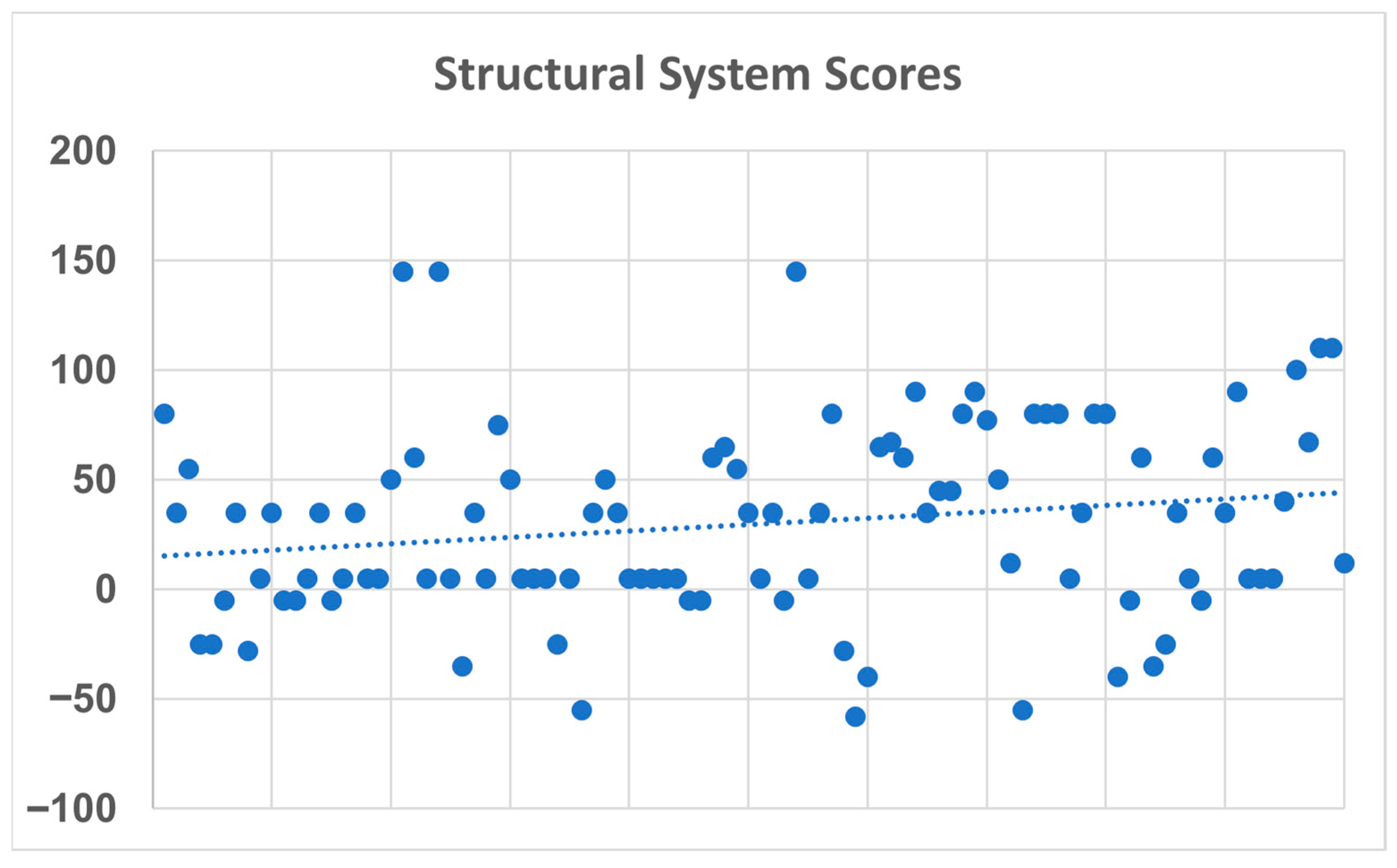
Structural result scores were obtained separately for the 100 existing RC buildings considered. The parameter and result score values obtained for the 100 different RC structures considered are shown in
Figure 28.
As stated in our study, the performance scores of the buildings were determined in accordance with the PDRB-2019 rapid assessment methodology, which provides a standardized and regulation-based framework for evaluating the seismic risk of existing RC structures. Each building’s performance score was calculated using a formula that integrates a base score (TP), a structural system score (YSP), and deductions score based on observable negative parameters (Oi × OPi). The trend line drawn in the study serves to visually represent the overall distribution and pattern of the performance scores obtained for the 100 evaluated buildings. By plotting the individual building scores and overlaying a trend line, the authors aim to illustrate the general tendency or direction in the seismic performance of the existing building stock in Bitlis. This line helps to highlight clusters, outliers, and potential risk concentration zones, providing a clearer understanding of whether the majority of buildings tend to have higher or lower risk scores. In an academic context, this trend line functions as a descriptive analytical tool, not for statistical prediction but rather for qualitative insight. It supports the interpretation of how performance scores vary across the sample, which in turn strengthens the argument for risk-based prioritization. Furthermore, the trend line offers visual support for identifying gradual or abrupt changes in score distribution, which can reflect underlying differences in construction quality, age, or structural irregularities in different parts of the urban fabric.
When the obtained results are examined, building distribution and classifications are made for each parameter in the rapid assessment process. The majority of the RC buildings examined were 6–7 storey buildings. Especially in the city centre affected by the 2011 Van earthquake, old buildings were replaced by newly constructed buildings. The topographic structure of Bitlis city centre, the hard climate conditions, and the scarcity of suitable areas for construction caused the number of stories to increase over time. The number of stories is one of the parameters that directly affect the damage and rescue efforts in earthquakes. In buildings under the effects of earthquakes, the mass will increase with the increase in the number of stories and as a result, the section effects that will occur under the effect of the earthquake will also increase. It is not very common to come across single storey RC buildings in the city centre.
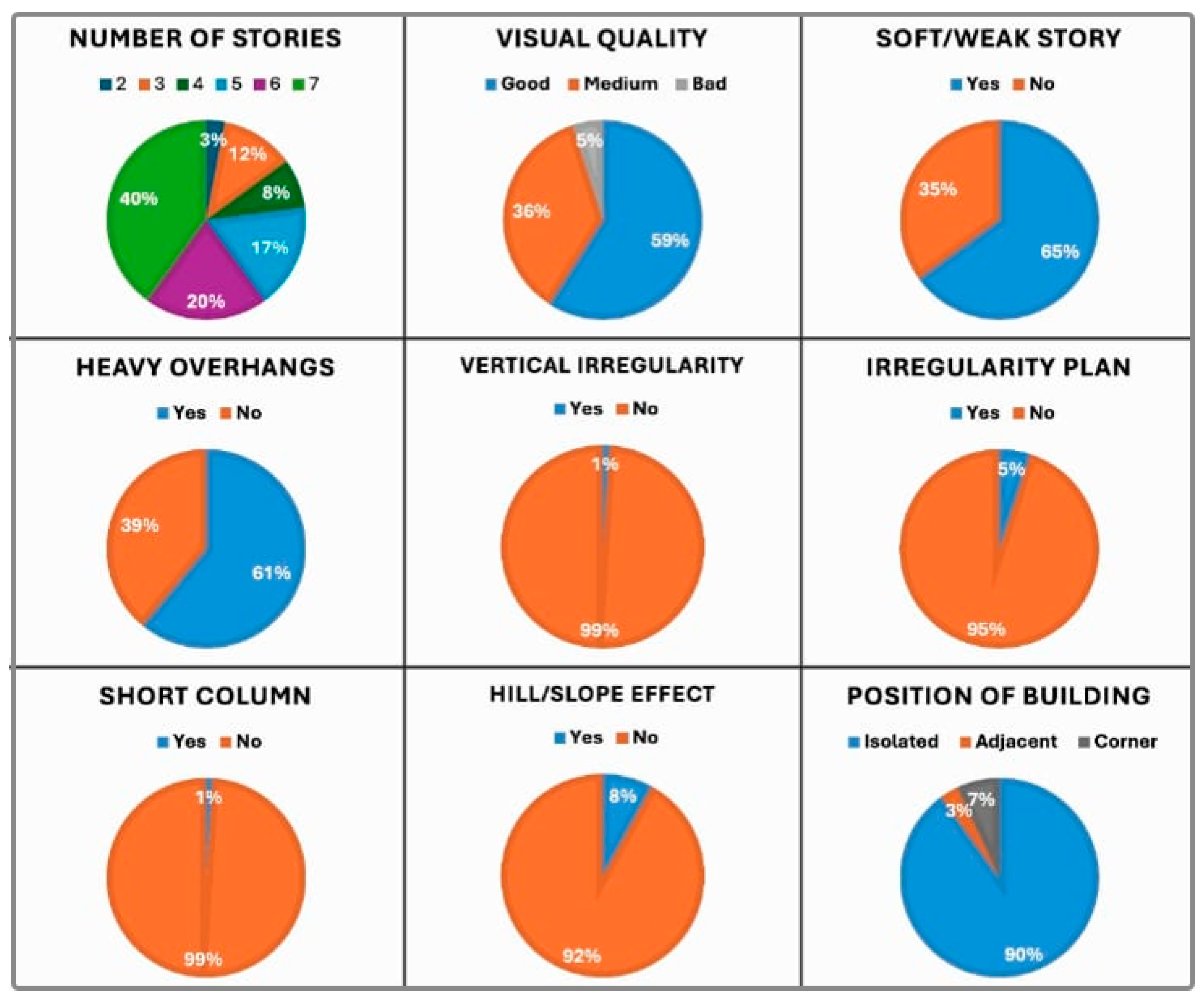
The majority of the buildings examined which were constructed in the rapid construction process in recent years has caused the visual quality of the building to be good in most of the cases. Therefore, the visual quality of the building was obtained as poor in very few of the RC structures examined. One of the main factors that causes partial or total collapse of ground stories in RC structures due to earthquakes is soft/weak story formation. This situation is also taken into account as a negativity parameter in the Turkish Rapid Assessment Method. The relatively observed soft/weak storey ratio is 65%, which is a high value. The differences in strength and rigidity between the stories forming the RC structure can cause damages on these stories. Especially, the buildings where commercial businesses are located on the ground floors and the other upper floors are used as residences by changing this usage purpose can cause relative soft storey damages. The city centre settlement shifted to the Hüsrevpaşa and Beşminare sub-districts and commercial businesses were placed on the ground stories of the new buildings built in these regions. The building distribution for the vertical irregularity situation is one of the parameters considered in the rapid assessment methodology. It is not easy to detect vertical irregularity in external inspections of buildings. It was observed that the vertical irregularity in the examined RC structures was at a very low rate of 1%. Compared to other negative parameters, it had a positive effect on the structural system scores within the scope of the existing building stock. Heavy overhangs constructed outside the RC frame can cause structural damage at different levels. Heavy overhangs were observed in 61% of buildings. The reason for this situation occurred due to the effect of arrangements in order to benefit more from the existing floor area. While it obtained a positive contribution from the existing area, it had a negative effect on the earthquake risk and significantly decreased the structural system scores in this study. The irregular construction of the buildings in the plan may negatively affect the seismic performance of the buildings. This negativity parameter, which we define as irregularity in the plan, defines the non-symmetrical plan in the structure. This situation, which can cause torsion in the building, was observed as 5% in our current building stock. The plan irregularity was primarily assessed through external visual inspections conducted during field observations. Necessary observations were made on all four facades of the building, and the plan was determined to be irregular. Short columns formed in structures can be damaged due to different reasons. Especially, short column damages caused by band type windows can cause serious damage to the structure. This situation was observed as 1% in current building stock that we examined. Although the very sloping topographic structure of the city centre is effective, this situation has not been observed very often. Although the central district of Bitlis province is a living area established in a valley and the slope and hills are many, it was observed that this situation is present in the current building stock examined at a rate of 8%. The mutual effect of adjacent structures on each other in an earthquake, i.e., the pounding effect, is also one of the negativities considered in this rapid assessment methodology. Although this situation has been observed more in the central district of Bitlis in previous years, after the demolition of the over-the-river structures built as a market centre in the city centre, the city centre settlement shifted to the Hüsrevpaşa and Beşminare sub-districts, and the new structures built here were constructed as relatively isolated. The distributions of these parameters are displayed in
Figure 29.
As a result of urbanization, an increase in the number of stories is observed. Consequently, 60% of the buildings examined are six- and seven-story RC structures. The fact that the buildings are new in construction means that the visual quality of the building is good in most of the buildings examined. Due to the habit of using ground stories for commercial objectives and upper stories for residential objectives, the presence of relatively soft floors was detected in 65% of the buildings examined. Heavy overhang applications to increase floor area on upper floors were observed in 61% of the buildings. Since irregularities in plan/vertical, hill/slope effect, and short columns are rarely observed, the rates obtained for these irregularities are quite low. Most of the buildings examined were constructed in an adjacent manner. The statistical distribution of negativity parameters of the structures considered in the research according to the sub-districts is given in
Table 9.
This study’s main goal is to implement the PDRB-2019 rapid assessment procedure to determine the seismic risk priorities of existing RC buildings in Bitlis city centre, a region characterized by high seismic hazard. Following the methodology prescribed by the official guidelines, the study produces a region-specific risk profile to inform local disaster risk management and urban planning efforts. By providing empirical insights into the structural vulnerabilities of the existing building stock, the study demonstrates the practical applicability of the PDRB-2019 method. It serves as a practical case study that emphasizes the importance of risk-based prioritization, without intending to evaluate or critique the method itself. According to the seismic performance scores obtained from the RC buildings in the central district of Bitlis, the average earthquake performance score was calculated as 30.51.
The earthquake performance scores of the 100 buildings examined in the district revealed that 21% of the buildings had scores between −80 and 0, while 79% scored between 0 and 150. In light of these findings, it is crucial to regularly monitor the regional building stock for earthquake risk and to take necessary measures for retrofitting or renovating structures with negative performance scores. In addition, current regulations should be implemented more effectively, and inspection processes tightened to minimize potential loss of life and property in future seismic events. This study will be a guiding source in planning and prioritizing urban transformation projects for both Bitlis central district and other regions with similar risks. Since the examinations in the study are based only on observation, they may vary from person to person and this may cause differences in the data obtained. Therefore, this examination serves as a preliminary step, and more detailed investigations should be conducted to achieve definitive results.
As noted, the observational nature of the rapid assessment process, as prescribed by PDRB-2019, inherently introduces a level of subjectivity, particularly for parameters such as visual quality, number of stories, structural system type, plan irregularity, and vertical irregularity, which are assessed without structural drawings or invasive inspection. Because rapid assessment methods for RC structures generally rely on visual observations and superficial inspections, the inspector’s experience, technical knowledge, and subjective judgments directly impact the accuracy of the process. The openness of the criteria used in such methods to interpretation can lead to inconsistencies in assessment results among different experts. For example, variability in the visual quality parameter, due to human factors, can reduce the reliability of the data obtained. Therefore, accurate determination of the parameters considered in the method is directly related to the inspector’s training and experience.
Nonetheless, the practical application of PDRB-2019 in Bitlis confirms the robustness of the method. More than 78% of high-risk buildings identified were found to have at least two critical negative parameters (e.g., soft stories, heavy overhangs, or short columns), demonstrating the method’s effectiveness in consistently prioritizing regional seismic risks. This highlights that, when applied carefully, PDRB-2019 provides reliable and actionable results for guiding risk-based decision making
The relationship between negative parameters and earthquake damage has been further elaborated by drawing explicit comparisons with the 2023 Kahramanmaraş earthquake. Post-earthquake field observations in Kahramanmaraş and surrounding provinces revealed that RC buildings with soft or weak stories experienced widespread collapse or severe damage due to insufficient lateral stiffness and concentration of drift demands at the ground story. Similar configurations were identified in the Bitlis building stock, and the majority of the evaluated buildings exhibited ground story irregularities consistent with soft story conditions. By linking these observed vulnerabilities in Bitlis to the documented failure mechanisms from the Kahramanmaraş earthquake, it is reasonable to infer that such buildings would face comparable risks of collapse or life-threatening damage under a major seismic event. This case-based comparison not only strengthens the empirical grounding of our analysis but also highlights the urgent need for targeted mitigation strategies for buildings with soft/weak story configurations in Bitlis.
6. Conclusions
With the growth of population and the consequent urbanization, the existing urban building stock continues to expand rapidly. The extent to which this increasing building stock is constructed in accordance with earthquake-resistant design principles and receives proper engineering oversight directly influences potential losses in the event of an earthquake. A key aspect of the pre-disaster preparation phase in modern disaster management is assessing whether the seismic performance of the regional building stock likely to be affected by an earthquake is adequate. Based on the information obtained from such assessments, it becomes necessary to identify buildings with insufficient seismic performance and to make informed decisions regarding their demolition or retrofitting, as required. The large number of existing building stock does not allow the detailed seismic performance of each structure to be determined in terms of time, expert personnel, and economy. It allows for a risk prioritization among the existing building stock in a certain region by using simplified methods or rapid assessment methods. The risk prioritization between structures was legally specified within the scope of the regulation published for the first time in Türkiye in 2013. Finally, with the seismic design code and earthquake hazard maps updated in 2018, mandatory changes in the proposed simplified methods have become inevitable. The 2013 method is based on a regional methodology, as in the earthquake zone map and earthquake code used at that time. The concept of earthquake zone is not used with the 2019 code. Therefore, in order to reveal the earthquake hazard of any region, the design spectral acceleration coefficient began to be used in the 2019 code. This was also effective in obtaining the hazard zone for the structure. The main purpose of the rapid assessment method in both years has not changed, and by using seismic and structural parameters, structural result scores for buildings should be determined, and buildings with lower scores should be examined in detail beforehand. According to the performance scores obtained, risk priority can be decided among buildings. Visuals on how the negativity parameters used in the method will be obtained from the structure prevent users from making incomplete or incorrect transactions.
In this study, which is limited to RC structures considered in the central district of Bitlis province, the negativity parameters in the rapid assessment method used for risk prioritization were examined in detail in light of the 2023 Kahramanmaraş earthquakes. In addition, visuals related to the buildings where these negativity parameters were observed in the central district were added to this study. The presence of one or more of the negativity parameters together will directly affect the seismic performances of the structures. The assessments revealed that soft/weak story formation (65%) and overhang elements (61%) were prevalent, particularly among six- and seven-story buildings. These parameters, consistent with observations from the 2023 Kahramanmaraş earthquake, significantly reduce the seismic performance of these structures. A significant portion of the performance scores obtained are in the low range, indicating that a significant portion of the region’s building stock is in need of seismic retrofitting or renovation. The systematic and rapid assessment provided by PDRB-2019 makes it possible to prioritize risky structures for more efficient resource utilization. It clearly demonstrates that it is necessary to pay particular attention to the concept of soft/weak storey, which is one of the causes of damage in RC structures in many earthquakes experienced in Türkiye, and to take the necessary precautions if necessary. Bülbül et al. [
42] used PDRB-2013, Işık [
44] used the METU rapid screening method, and Işık and Kutanis [
45] used the P25 method. The difference of this study from other rapid assessment studies conducted in Bitlis province was that PDRB-2019 was applied for the first time. Since the RC buildings examined in all of these studies were different buildings, no comparison could be made. Bülbül et al. [
42] reported that 62% of the buildings they examined had soft/weak stories, while Işık [
44] reported that 65% of the buildings he examined had soft/weak stories. This study found this rate to be 65%. This suggests that the primary drawback in buildings in the city centre is the presence of soft/weak stories. This is due to the changing usage of the building. The primary reason for this is the use of the ground story for commercial purposes and upper stories for residential purposes. Another reason is that ground stories are constructed higher than other stories. This practice should be abandoned or necessary structural measures should be taken to mitigate potential earthquake damage.
As in many provinces of Türkiye, RC structures constitute the dominant urban building stock in Bitlis province. Especially in the city centre affected by the 2011 Van earthquake, construction became faster after this earthquake. The RC building stock in Bitlis city centre consists primarily of mid-rise buildings constructed after 1980, lacking or limited in the use of engineering services. These structures are generally residential, although mixed-use structures with commercial units on the ground stories are also common. RC systems are predominantly column-and-beam frame systems. However, with the implementation of the building inspection system in Türkiye after the 2011 Van earthquake, RC frame and RC shear wall systems have become widespread, and the construction of high-rise buildings, albeit in small numbers, has begun. Especially, many regular structures were constructed by the Housing Development Administration of the Republic of Türkiye (TOKİ). TOKİ aims at fundamentally producing solutions to the problems with regard to housing and urbanization in Türkiye at a national scale, and continues its activities to realize an adequate number of quality housing in healthy urban environments of the country. In most of these structures constructed with the tunnel formwork system, the number of floors was kept low and the purpose of use did not change in the structure. Within the scope of TOKİ urban transformation, earthquake-resistant structures were built within the scope of urban transformation instead of disaster housing in the Hüsrevpaşa sub-district and delivered to the building owners and had started to be used. In addition to these, especially in the settlement known as 160 Evler sub-district, urban transformation was carried out with the contributions of Bitlis Municipality instead of the houses known as disaster housing and structures in accordance with the current earthquake regulations were designed and started to be built. A large part of these completed structures have started to be used. Therefore, it can be said that these structures built in large numbers in this way will have much more earthquake resistance compared to old structures. While there are many adjacent structures in older structures, detached structures are generally built in areas where there are new constructions. The presence of soft/weak story and heavy overhang projections comes to the forefront as irregularities in the city centre of Bitlis. Negative parameters such as irregularity in the plan, irregularity in the vertical, hill–slope effect, and short columns were not observed much in the examined buildings. The fact that the structures were built especially in recent years has allowed the visual quality of the structures to be good. Structures subjected to earthquakes may exhibit weaknesses in their structural systems due to factors such as design flaws, construction deficiencies, and environmental influences. Moreover, adverse structural effects arising from changes in the building’s function can further contribute to earthquake-induced damage. Inadequate design, poor-quality materials, substandard workmanship, and insufficient quality control all play a critical role in the destructiveness of such damage. The structural characteristics of buildings exposed to seismic effects are directly proportional to potential loss of life and property during an earthquake. Additionally, accurately assessing local ground conditions is essential for meaningful structural design and evaluation.
Attention should be paid to the creation of RC shear walls that will serve as earthquake shear walls in the proportions to be determined in all types of newly constructed RC buildings during the design phase. Not using hollow block floors is seen as an important advantage for structures, because the seismic performance of hollow block floors is lower than RC slab systems. For this reason, it would be beneficial to ban the use of hollow block floors in all structures. In order to prevent soft/weak story formations in buildings other than those that are entirely commercial and industrial, prohibiting the change of mezzanine floors and story heights within the structure will provide additional benefits in preventing property and life losses during an earthquake. In concrete casting, building inspection organizations, municipal regional engineers, and site managers should be warned to pay utmost attention to vital issues such as preparation, transportation, temperature, weather conditions, pouring height and duration, compression, taking test samples, and post-pouring maintenance and curing, and sufficient inspections should be carried out on these issues. Necessary measures should be taken to prevent electrical and plumbing installations from passing through the structural system elements (beams, columns, RC shear walls). With the healthy monitoring of structures, changes can be monitored after the use of the structure. In this context, by implementing a QR code application by the municipality, it will be possible to ensure that the structure is checked at certain intervals after it is put into use and this information is transferred to the system.
Analyzing the earthquake performances of RC buildings in the central district of Bitlis province with rapid assessment methods provides extremely valuable results in terms of understanding the general status of the building stock in the region and directing risk prioritization processes, especially, the urban transformation projects and new ones that have been launched recently. The study verifies the performance scores of the buildings by applying the PDRB-2019 rapid assessment method, which quantifies seismic vulnerability based on a scoring system that integrates both positive and negative structural parameters. The procedure does not involve structural modelling or numerical simulation; instead, it relies on visual inspections, field data, and regional seismic hazard values derived from the Türkiye Earthquake Hazard Map. The rapid assessment methodology used in this study, based on visual inspection procedures defined by PDRB-2019, is relatively simple and effective, particularly in urban environments with densely populated buildings, such as Bitlis city centre. However, the selection of 100 RC buildings was a deliberate methodological choice intended to provide a representative yet manageable sample size for pilot-scale implementation of the updated assessment framework. This initial dataset allowed for the identification of dominant structural irregularities and risk trends across different sub-districts while maintaining consistency and quality in data collection. Furthermore, as this is the first study to apply the PDRB-2019 methodology at this scale in Bitlis, it aims to establish a baseline dataset for regional risk prioritization. However, given the operational simplicity of the method, we agree that future studies could benefit from an expanded dataset to increase statistical robustness and spatial resolution. The findings of the study demonstrate that the PDRB-2019 method is a practical and applicable tool for field applications and also provides a scientific basis for urban transformation projects in high-risk areas like Bitlis. However, since the method relies solely on visual inspection, it can lead to subjective differences in the evaluation process, and it should be supported by detailed engineering analyses for structures below the critical threshold. Furthermore, the findings of this study will inform future large-scale building stock surveys and regional risk mapping in earthquake-prone settlements like Bitlis. In conclusion, this study provides an important example of the field application of the PDRB-2019 and provides concrete data-based contributions to decision-making processes aimed at reducing disaster risks.
One of the most important factors in the first-stage evaluation of buildings is their visual quality. The strength of the materials used in a building directly affects its performance. For any building, the attention paid to the quality of workmanship and materials during and after its construction determines its quality. Three different classifications for a building’s apparent quality are offered: good, medium, and poor. However, determining this accurately depends on many factors. Chief among these is the need for the person collecting the information about the building to be trained and experienced in the building and its materials. The fact that a building has undergone renovations will directly impact the decision-maker’s judgment regarding its visual quality. Furthermore, the cladding materials used in buildings can hinder accurate judgments regarding its quality. In a sense, determining the visual quality of a renovated building often fails to yield reliable results.
PDRB-2019 primarily incorporates the local soil class via the design spectral acceleration (SDS) parameter, providing a simplified yet practical representation of the seismic demand at the site. While this approach has been shown to be sufficiently accurate for large-scale risk prioritization, its accuracy is inevitably limited compared to more detailed analyses that explicitly account for complex soil effects and soil–structure interaction. Studies have shown that factors such as basin amplification, nonlinear soil response, and foundation flexibility can significantly alter structural demands and, in some cases, alter fragility classifications for boundary structures. Therefore, while we acknowledge that the use of soil class provides methodological efficiency and consistency across large inventories, accuracy could be improved by incorporating advanced field response analyses or soil–structure interaction models, particularly for critical facilities or high-risk areas.
Rapid assessment methods reveal structural deficiencies across a wide range of parameters, resulting from different requirements. What engineers can do is develop and implement appropriate methods to mitigate the negative effects of these deficiencies. For example, ground floors are often higher, or relatively soft stories can occur due to the absence of infill walls. This is often part of architectural planning. The engineering task is to design soft floors so that they are not simultaneously weak. In addition to all these negative parameters, it is thought that it would be appropriate to add a parameter score related to strong column–weak beam, which is one of the critical factors in structural damage.
In order to clarify the determination of the critical performance threshold and the formulation of retrofitting priorities, an additional explanation has been included. According to the logic of PDRB-2019, building risk is evaluated by deducting points for the presence of negative parameters from a base score, and a structure can be considered high risk when the cumulative deduction points exceed approximately 50% of the initial score, indicating a significant loss of seismic safety. In our dataset, 21% of buildings scored between –80 and 0, which clearly places them in this high-risk category and makes them immediate candidates for retrofitting or replacement. The remaining 79% of buildings with scores between 0 and 150 fall into moderate- to low-risk classes, where retrofitting priorities can be established by ranking sub-districts with higher concentrations of negative parameters such as soft stories or heavy overhangs. This threshold-based approach is consistent with local risk mitigation policies in Türkiye, where municipalities prioritize intervention for the most vulnerable buildings first, thereby enhancing the practical application value of the study’s conclusions.
While the subjectivity of PDRB-2019 has previously been attributed mainly to its reliance on visual inspection, the evaluation of the method has now been strengthened by proposing measures to mitigate this limitation. Specifically, structured training programs can be implemented to refine inspectors’ judgment criteria based on standardized specifications, while on-site training sessions using documented examples of structural defects—such as soft stories, short columns, and heavy overhangs observed in this study—can further improve consistency. In addition, establishing a cross-validation mechanism, where survey teams independently assess a subset of buildings and compare results, can reduce individual bias. The use of simple technical tools, such as laser rangefinders for measuring overhang dimensions or mobile applications for recording irregularities, can also provide objective support for visual observations. Collectively, these strategies enhance the reliability of PDRB-2019 by reducing subjectivity and ensuring that rapid assessments are both practical and consistent across different inspectors and regions.
Conducting large-scale rapid assessments in dense urban areas such as the city centre of Bitlis presents several challenges, including restricted accessibility, poor cooperation from property owners, and the time-consuming nature of manual data collection. To address these limitations, complementary strategies can be employed: drone-based aerial photography can be used to preliminarily identify building appearance features (e.g., number of stories, visible irregularities), while collaboration with local governments can facilitate access to urban GIS databases to obtain basic information on construction age, occupancy, and permitted uses. Additionally, stratified sampling by sub-district, building age, and structural type can improve efficiency and ensure representative coverage. Furthermore, policies can restrict the mixed-use configuration of “commercial lower floors with residential upper floors,” which has been shown to increase vulnerability, particularly in renewal projects. Finally, integrating these rapid assessment results into municipal seismic hazard maps can support a balanced allocation of resources, aligning retrofit priorities with both cost considerations and safety objectives.
In addition to structural parameters, socio-economic or local factors such as building usage (e.g., dense population in commercial lower floors in the city centre of Bitlis), economic level (low-income groups may be unable to afford retrofitting costs), and terrain and secondary disasters (the city is located in a valley, and areas with slopes exceeding 30° may suffer aggravated damage due to landslides) may affect seismic risk. It is recommended that future studies incorporate these factors.
The outcomes of this study have important implications for urban transformation and disaster risk reduction policies. First, municipalities can adopt the PDRB-2019 framework as a standardized and regulation-compliant tool for rapid screening of RC buildings. Second, integration of rapid assessment results into local decision-making processes can guide the prioritization of retrofitting efforts and ensure more efficient allocation of limited resources. Third, consistent monitoring of the building stock—through periodic surveys, digital recording systems, and local inspection programs—will improve the reliability of seismic risk management. Finally, prohibiting structural practices that lead to soft/weak story formation and encouraging the inclusion of RC shear walls in design will significantly enhance structural resilience. Collectively, these measures will support the development of safer and more disaster-resilient urban environments in Bitlis and other high-risk regions of Türkiye.
To further enhance data collection efficiency, modern tools can be incorporated, such as AI-based image recognition to automatically extract the number of stories and visible defects from field photos, 3D laser scanning to capture accurate building geometries, and mobile applications that record structural parameters with geographic coordinates and directly link results to the Turkish seismic hazard map. These technologies can significantly accelerate dataset expansion while improving accuracy and consistency in large-scale rapid assessments. For long-term risk management, a dynamic database can be established to integrate initial PDRB-2019 scores with retrofitting records and continuously update building status using QR code applications, while micro-seismic sensors installed in critical parts of high-risk structures can provide real-time performance data. Additionally, conducting periodic re-assessments every 3–5 years with PDRB-2019 will help track changes in vulnerability and evaluate the effectiveness of retrofitting measures.
