Article

Study on the Evolution Mechanism of Cultural Landscapes Based on the Analysis of Historical Events—A Case Study of Gubeikou, Beijing

1
School of Architecture and Urban Planning, Beijing University of Civil Engineering and Architecture, Beijing 100044, China
2
Urban and Rural Heritage Data Research Institute, Beijing University of Civil Engineering and Architecture, Beijing 100044, China
*
Author to whom correspondence should be addressed.
These authors contributed equally to this work.
Buildings 2025, 15(19), 3495; https://doi.org/10.3390/buildings15193495
Submission received: 10 August 2025 / Revised: 11 September 2025 / Accepted: 22 September 2025 / Published: 28 September 2025
(This article belongs to the Special Issue Advanced Research on Cultural Heritage—2nd Edition)

Abstract

The cultural landscape of Gubeikou, with distinct historical stratification and event-relatedness, bears unique value. Against the backdrop of increasingly prominent themes of cultural heritage development and transformation, research on Gubeikou’s cultural landscapes remains fragmented and lacking in depth. This research explores its evolution mechanism via historical events to fill gaps. This study takes Gubeikou Town as the research object, applies the text analysis method to sort and categorize 302 historical events, summarizes 12 event types, identifies 19 landscape elements, and constructs a data matrix based on co-occurrence frequencies. It performs clustering analysis on these using Principal Component Analysis (PCA) and Agglomerative Hierarchical Clustering (AHC), while integrating historical and geographical data. Findings: (1) The landscape evolution of Gubeikou can be divided into four main stages: the military embryonic period, the functional expansion period, the system maturity period, and the multi-element integration period. (2) The dynamic evolutionary trajectory of the correlation between its landscapes and events shows that the core factors affecting the evolution of cultural landscapes in each period not only maintain the dominance of military elements throughout the evolutionary process but also integrate diverse elements like economy, culture, and folk customs with social development, presenting the characteristics of composite evolution. (3) The landscape evolution is driven by the “primary–secondary synergy” dynamic structure composed of four types of activities: military–political, transportation, production–trade, and construction. It is the product of the coupling effect of political goals, social operation, and geographical conditions. This study provides a basis for the sustainable protection and utilization of Gubeikou, and also offers a reference for other regions.

1. Introduction

As a composite heritage of long-term interaction between humans and nature, cultural landscapes carry the symbiotic memories of material space and intangible culture [1,2], and their “dynamic evolution” has become a core issue in heritage protection and historical geography research [3,4]. As the largest military defense project in human history [5], the military settlements along the Great Wall are not only material carriers of geostrategic concepts in the cold weapon era [6] but also typical cultural landscapes reflecting the coupling effect of natural environment and human activities [7]. Among them, Gubeikou, located at the throat of the Yanshan Mountains, which once controlled the transportation hub, has served as a core pass for Central Plains dynasties to resist northern nomadic peoples—from its establishment as a military pass in the Northern Qi Dynasty to its prosperity in the Ming and Qing Dynasties. The cultural landscape of its military settlements [8] not only embodies the common characteristics of the Great Wall defense system but also forms distinct regional uniqueness due to its unique geographical location and the background of multi-ethnic integration. Moreover, due to functional changes [9,10,11,12,13] caused by political situation changes in successive dynasties, Gubeikou’s cultural landscape presents distinct temporal–spatial stratification and correlation with historical events, making it an ideal case for analyzing the dynamic evolution of cultural landscapes.
The core of cultural landscape research is to reveal the symbiotic logic between material elements and intangible culture. The Operational Guidelines for the Implementation of the World Heritage Convention revised by UNESCO in 2025 [14] point out that the core connotation of cultural landscapes, while continuing the essence of “the combined works of nature and man”, further emphasizes “the dual dimensions of deep symbiosis between material carriers and intangible values, dynamic evolution, and sustainable correlation”. On this basis, existing studies proceed from multiple perspectives such as everyday practice [15], dynamic evolution of heritage [16], eco-cultural interaction [17,18], social network and spatial transformation [19], and cluster protection and network science [20], focusing on the formation mechanisms and cultural connotations of typical cultural landscapes such as military heritage [21], traditional settlements [22,23], historical districts [24], and linear heritage [25]. The studies, based on theories such as network science [20], Complex Adaptive System (CAS) theory [26], and memetics [27], and by employing methods such as social network analysis [19], Multiscale Geographically Weighted Regression (MGWR) [28], Monte Carlo simulation [29], Historical Geographic Information System (HGIS) [30], image semantic segmentation [31], and construction of landscape gene maps [32], systematically explore the interaction mechanisms, evolution laws, genesis mechanisms, and protection and utilization strategies of material elements and intangible culture in cultural landscapes, build an interdisciplinary analytical framework for revealing the deep-seated logic of landscape evolution, and confirm that landscape evolution is the result of the coupling effect of natural environment, social structure, and cultural practice.
In recent years, research on the evolution mechanism of cultural landscapes has shown a trend of integration of “qualitative–quantitative” methods, and the research perspective based on historical events has brought new breakthroughs to dynamic heritage research. Historical events record local activities in historical contexts and directly influence the formation and shaping of historical landscapes, thus providing an objective basis for studying the changes in cultural landscapes [33]. Current cultural heritage practices around the world have confirmed this value. Rooted in political transformations [34] and local community practices [35], the interpretation of cultural values is approached from the historical perspectives of both upper and lower social strata. Meanwhile, modern formats such as tourism [36], tabletop games [37], and digital technologies [38,39] are leveraged to enhance the interpretation of historical and cultural events.
On this basis, text analysis [40] and Natural Language Processing (NLP) [41] provide a pathway for quantitative analysis of historical events. By being combined with methods such as Artificial Intelligence (AI) [42,43], GIS analysis [44], GNSS action tracking [45], cluster analysis [46], and network analysis [47,48], event information can be extracted from works such as policy documents [49,50], poems [40,47], travel notes [51,52], and architectural murals [53,54], revealing the correlation between natural and human landscape elements from a specific perspective; which provides theoretical support for analyzing the interactive relationship between landscapes, historical social culture, and nature, as well as proposing sustainable protection strategies. These interdisciplinary studies, from case practice to the summary of universal laws, have confirmed the driving role of historical events in the evolution of cultural landscapes and provided multiple empirical bases for analyzing the dynamic evolution logic of cultural landscapes, which fully demonstrates the necessity of studying cultural landscapes based on historical events.
Research on the Great Wall landscape has formed a multi-dimensional system ranging from macro-level systematic analysis to micro-level element focus. At the macro level, studies take the Great Wall as a linear heritage, exploring its overall structure and cross-regional connections [55]. Additionally, combining fractal theory [56], GIS analysis [57,58], Landscape Character Assessment (LCA) [59], and network analysis [60], they provide insights for the sustainable development of the Great Wall cultural heritage from professional perspectives such as landscape planning, cultural and tourism development [61], and ecological risk assessment [57,62]. Moreover, the dynamic evolution and quantitative analysis of the Great Wall heritage are key research focuses; through analyzing its spatio-temporal distribution characteristics [62], the evolution mechanism of the Great Wall heritage is revealed [60]. At the micro level, based on typology, studies reveal the unity of function and form in military settlements [63], clarifying the role of natural landforms and military needs in shaping specific landscape patterns [64]. However, existing studies still have shortcomings, such as insufficient attention to intangible cultural stratification, fragmented research on the process of historical event-driven landscape iteration, and lack of quantitative analysis of landscape cultural correlations [65], which urgently need further deepening under the theoretical framework of cultural landscapes.
Taking Gubeikou as the research object, this study systematically sorts out 302 historical events through text analysis, and combines PCA to quantitatively analyze the coupling mechanism between cultural landscapes and historical events, thereby addressing the fragmentation of historical event-driven landscape iteration processes. It focuses on intangible cultural stratification to deepen the understanding of multi-dimensional cultural landscape evolution. This research not only reveals the evolutionary mechanism of Gubeikou’s own landscape but also provides a referential analytical paradigm for related studies under the cultural landscape theoretical framework, with significant theoretical and practical value.

2. Methods

2.1. Research Scope

Gubeikou Town, selected in this study, is specifically located at the southern entrance of the Chaohe River Gorge in the remaining range of the Yanshan Mountains. It serves as a key pass connecting the North China Plain, Northeast China Plain, and Inner Mongolia Grassland, with an administrative area of 85.82 square kilometers and jurisdiction over 9 administrative villages (Figure 1). Benefiting from its unique and important geographical location, the town has long been a core stronghold for military defense in history. Defensive facilities continuously built in successive dynasties, combined with rich cultural heritage left by multi-ethnic integration, have jointly shaped the unique cultural landscape of this region [66].
Tracing its historical context, Gubeikou originated in the Warring States Period. It started as a military pass on the boundary between Yan and Ji during the Warring States Period and developed into a major military and economic town in the Ming and Qing Dynasties [9,13]. Its cultural landscape exhibits strong temporal–spatial stratification and correlation with historical events. This characteristic makes Gubeikou an ideal typical case for analyzing the laws of dynamic evolution of cultural landscapes through systematically examining sequences of historical events.

2.2. Research Methods

2.2.1. Text Analysis Method

Text analysis enables the clear organization of a document’s core content and implicit trends by systematically deconstructing texts, extracting key information, exploring latent patterns, and quantifying core concepts, thereby providing a structured interpretation pathway for research [67,68]. Current text analysis methods mainly fall into two categories: one uses software such as TEXTOM v0.2.5 [69], KH Coder v3.02 [46], and Maxqda v24.9 [70], while the other relies on Natural Language Processing (NLP) technologies (e.g., BERT [71], LDA [41] models). NLP is more suitable for unsupervised semantic mining of large-scale modern texts, whereas text analysis software is more practical for the fragmented historical documents—the core data source of this study. This is because historical text fragments are short and dependent on specific contexts, which avoids semantic misjudgments caused by insufficient training data in NLP applications.
This study selected Maxqda [72] primarily due to its suitability for the in-depth analysis of historical documents. First, through the creation of codes and subcodes, it enables the simultaneous implementation of event coding and landscape element annotation for individual historical records. Second, its visual coding matrix can intuitively present the co-occurrence relationships between events and landscapes, which addresses the limitation of purely quantitative Natural Language Processing (NLP) that prioritizes statistics over context in small-scale historical text analysis. In practice, researchers imported historical documents into Maxqda to systematically organize historical events in the Gubeikou Town area, categorize event types and landscape types, and calculate their co-occurrence frequencies in the texts. In the formula, f 1 2 represents the frequency of simultaneous occurrence of element 1 and element 2, N is the total number of events, and the corresponding frequency is P 1 2 .
P 1 2 = f 1 2 N

2.2.2. Principal Component Analysis

As a classic multivariate statistical dimensionality reduction technique [73], the core value of Principal Component Analysis (PCA) lies in transforming multiple correlated original variables into a small number of mutually independent “principal components”. While simplifying the data structure, it retains core correlation information, thereby efficiently revealing the latent patterns underlying the data. For the “event type-landscape element” correlation data extracted from historical documents, PCA can accurately address the core analytical needs of this study: based on the “event type-landscape element” co-occurrence matrix obtained through text analysis, it converts qualitative coding results into interpretable “driving factor indicators” via principal component extraction.
In this study, a data matrix was constructed by counting the co-occurrence frequency of landscape elements and event types. The data were then standardized to generate a biplot of principal component loadings. This method was used to analyze the core factors affecting the correlation characteristics between the two, and further reveal the cultural mechanisms driving landscape formation. The relevant formulas of the method are as follows (Table 1):

2.2.3. Agglomerative Hierarchical Clustering

To verify the reliability of the clustering results for “event types–landscape elements” derived from PCA, this study introduces Agglomerative Hierarchical Clustering (AHC) [74] as a cross-validation method. In this research, “landscape elements” are treated as variables, each regarded as an initially independent cluster. The Euclidean distance is used to calculate the correlation strength between clusters, a dendrogram is constructed, and the optimal number of clusters is determined based on the “elbow point”. By progressively merging or splitting clusters, this method constructs a clustering system with a hierarchical structure, which can form complementary validation with the dimensionality-reduced clustering results of PCA. In the formula, z x i denotes the i-th standardized sample value of variable x , z y i represents the i-th standardized sample value of variable y, and d ( x , y ) stands for the Euclidean distance between variables x and y , with a smaller value indicating a stronger correlation between the two.
d ( x , y ) = i = 1 n ( z x i z y i ) 2

2.3. Data Processing for Text Analysis

This study constructs a historical data system using official dynastic histories such as Imperially Approved Twenty-Four Histories (≪钦定二十四史≫) [75], Veritable Records of the Ming Dynasty (≪明实录≫) [76,77], Veritable Records of the Qing Dynasty (≪清实录≫) [78], supplemented by local chronicles like Miyun Gazetteer (≪密云县志≫) [79,80] and inscriptions on steles (Table 2). By sorting out the name changes of Gubeikou and location references (e.g., the pass of “Tanzhou Dao” (檀州道) belonging to the Yan State during the Warring States Period, the vicinity of “Tixie Cheng” (提携城) in the Han Dynasty, “Beikou” (北口) in the Tang Dynasty, and “Gubeikou” (古北口) from the Song Dynasty to the present; “Chaohe River” (潮河), “Miyun” (密云) and their ancient names can be used as location references), the geographical locations described in the classics are identified, and historical events are excavated.
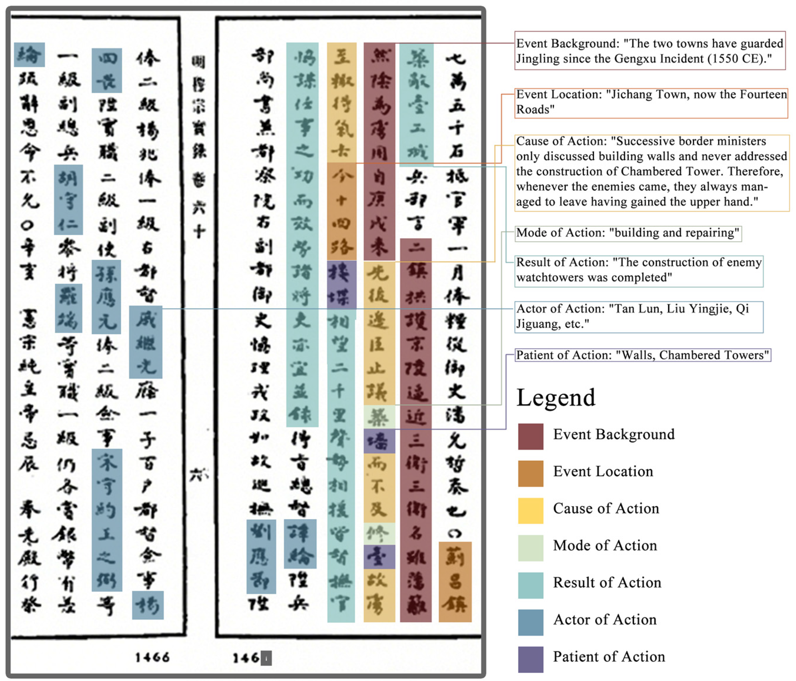
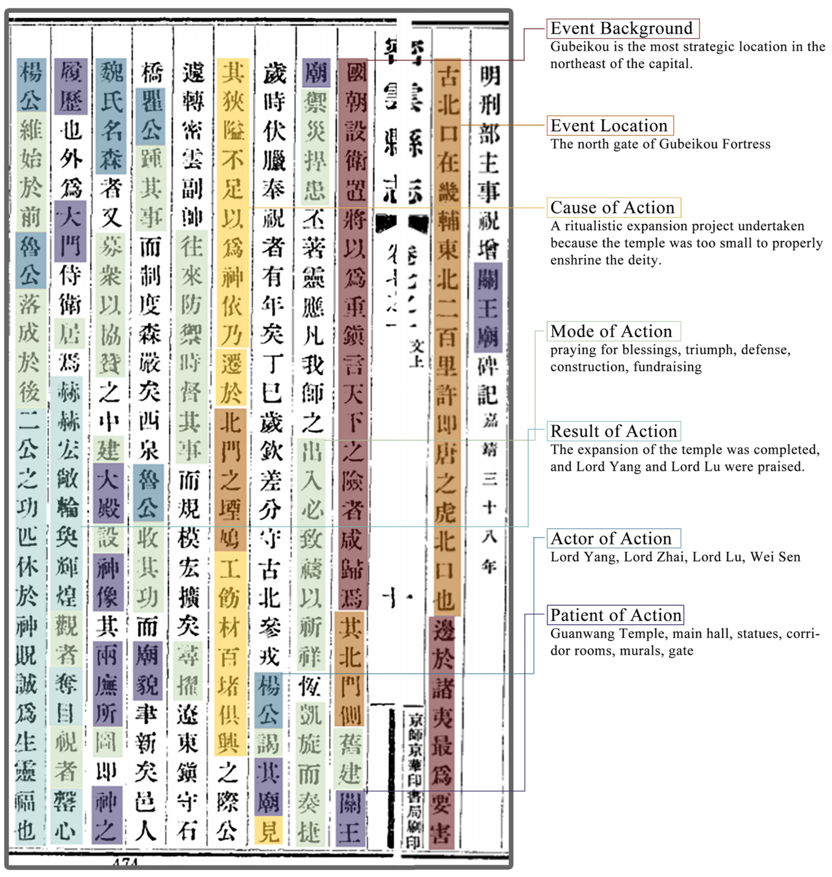
Drawing on the framework of spatial narrative grammar [81,82]—external conditions of events (event location, event background) and constituent elements of events (cause of action, mode of action, result of action, actor of action, patient of action)—the text structure of events is analyzed. Taking a fragment from Veritable Records of the Ming Dynasty (≪明实录≫) as an example (Figure 2), this event records that after the Gengxu Incident (庚戌之变) (event background), “Tan Lun, Liu Yingjie, Qi Jiguang” (谭论、刘应节、戚继光) (subjects) carried out construction (action method) on “watchtowers” (敌台) (objects) in the “Fourteen Routes of Jichang Town” (蓟昌镇十四路) (place), and the result of this action.
The study sorted out 302 historical events explicitly referring to cultural landscapes. Based on the results of text analysis, these events are categorized into 12 event types (Table 3), and the landscape elements mentioned in the events are divided into 19 categories according to their functions and characteristics (Table 4). Through field surveys and archeological verification, these elements are correlated with the existing cultural landscapes in Gubeikou. All landscape elements mentioned in the literature have corresponding counterparts in the Gubeikou area, reflecting the cultural continuity in the development of local landscapes and providing feasibility for the theoretical verification of this study.

2.4. Research Path

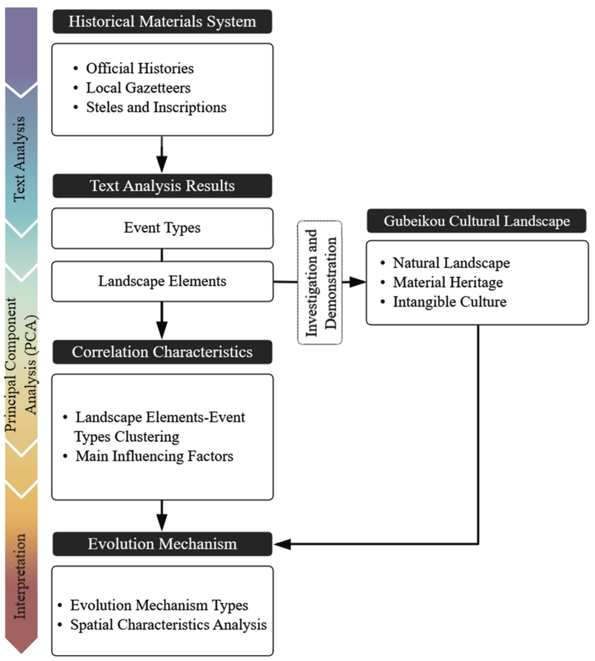
This study systematically sorts out the historical events of Gubeikou through the text analysis method. Based on text analysis, it further summarizes event types and landscape elements, counts their co-occurrence frequency (i.e., the number of simultaneous occurrences in the same event), and constructs a data matrix. Combining archeological verification and existing landscapes, it conducts corresponding analysis, uses PCA to cluster landscape elements and event types, and explores the core factors affecting the characteristics of their correlation. Finally, by integrating geographical information data of historical events and Gubeikou’s cultural landscapes, it systematically reveals the evolution mechanism and temporal–spatial accumulation characteristics of Gubeikou’s landscapes (Figure 3).

3. Results

3.1. Study on the Historical Context of the Gubeikou Area and Influencing Factors in Periods

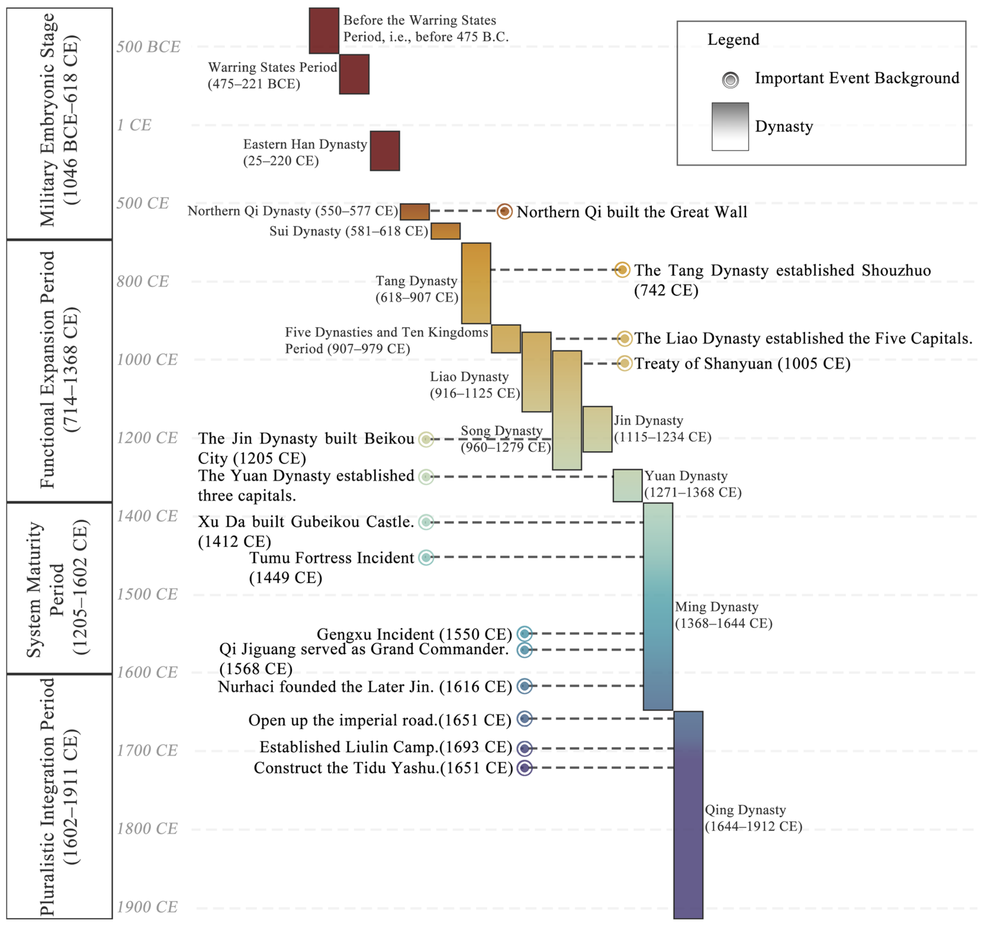
By systematically collating historical documents, this study clarified the dynasties and key temporal nodes of historical events recorded in the literature within the Gubeikou region (Figure 4), and divided these events into four developmental periods of Gubeikou’s historical culture based on critical nodes (Table 5).
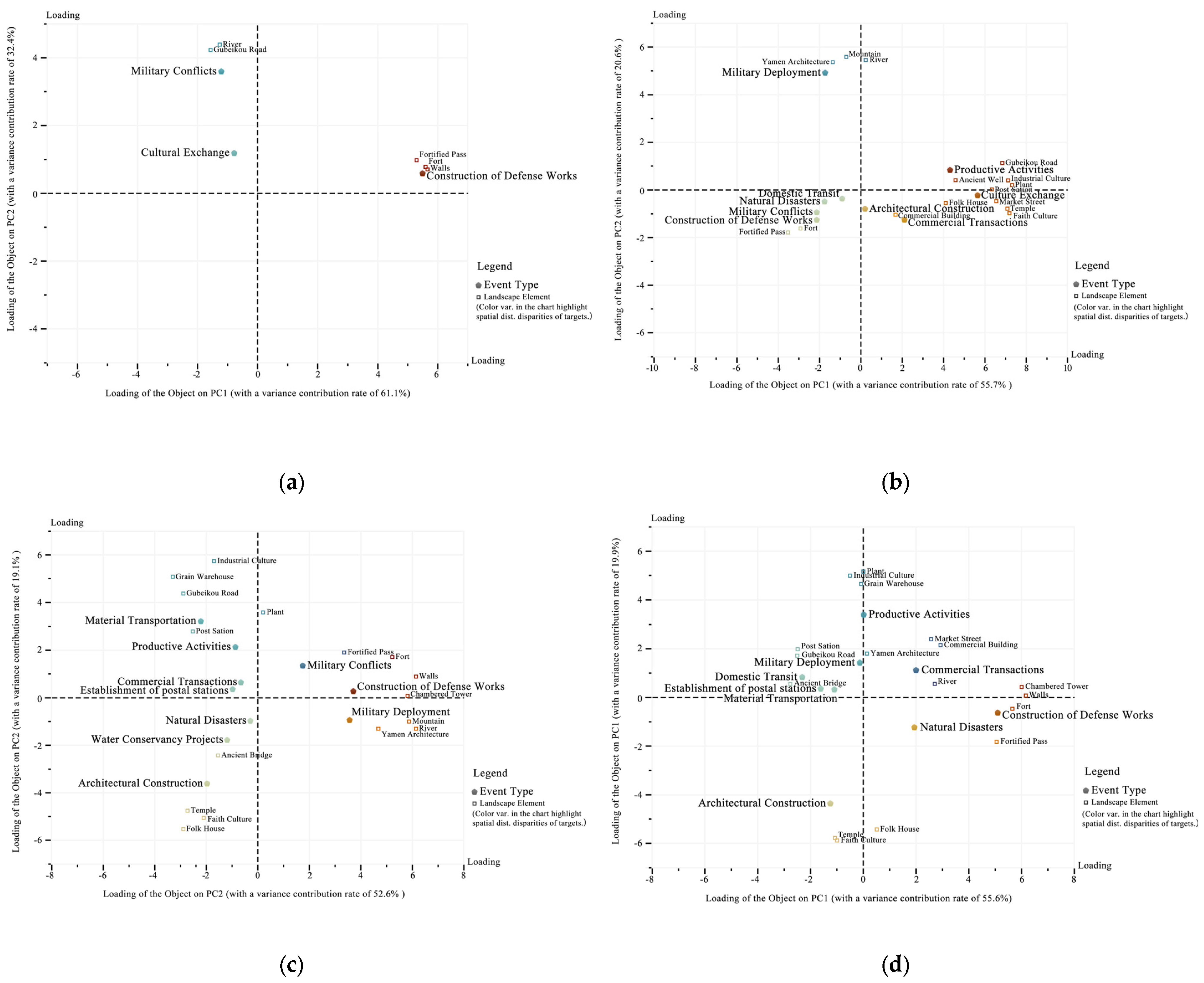
To explore the changing trends of core influencing factors affecting the correlation characteristics between event types and landscape elements in the Gubeikou region over the historical development process, this study employed PCA: By taking event types as analytical samples and using the co-occurrence frequencies of landscape elements with different event types across periods as variables, this study constructed a basic data matrix. The data were subjected to standardization, and an overall KMO test was conducted to ensure a value exceeding 0.7 for subsequent PCA. Biplots illustrating the correlation characteristics of event types and landscape elements across periods in the dimensions of PC1 and PC2 were generated (Figure 5)—in these plots, the abscissa (PC1) and ordinate (PC2) represent the loadings of each object on the two principal components, respectively. Objects with proximate spatial positions or located in the same quadrant can be identified as being driven by the same underlying factors (i.e., exhibiting high correlation).
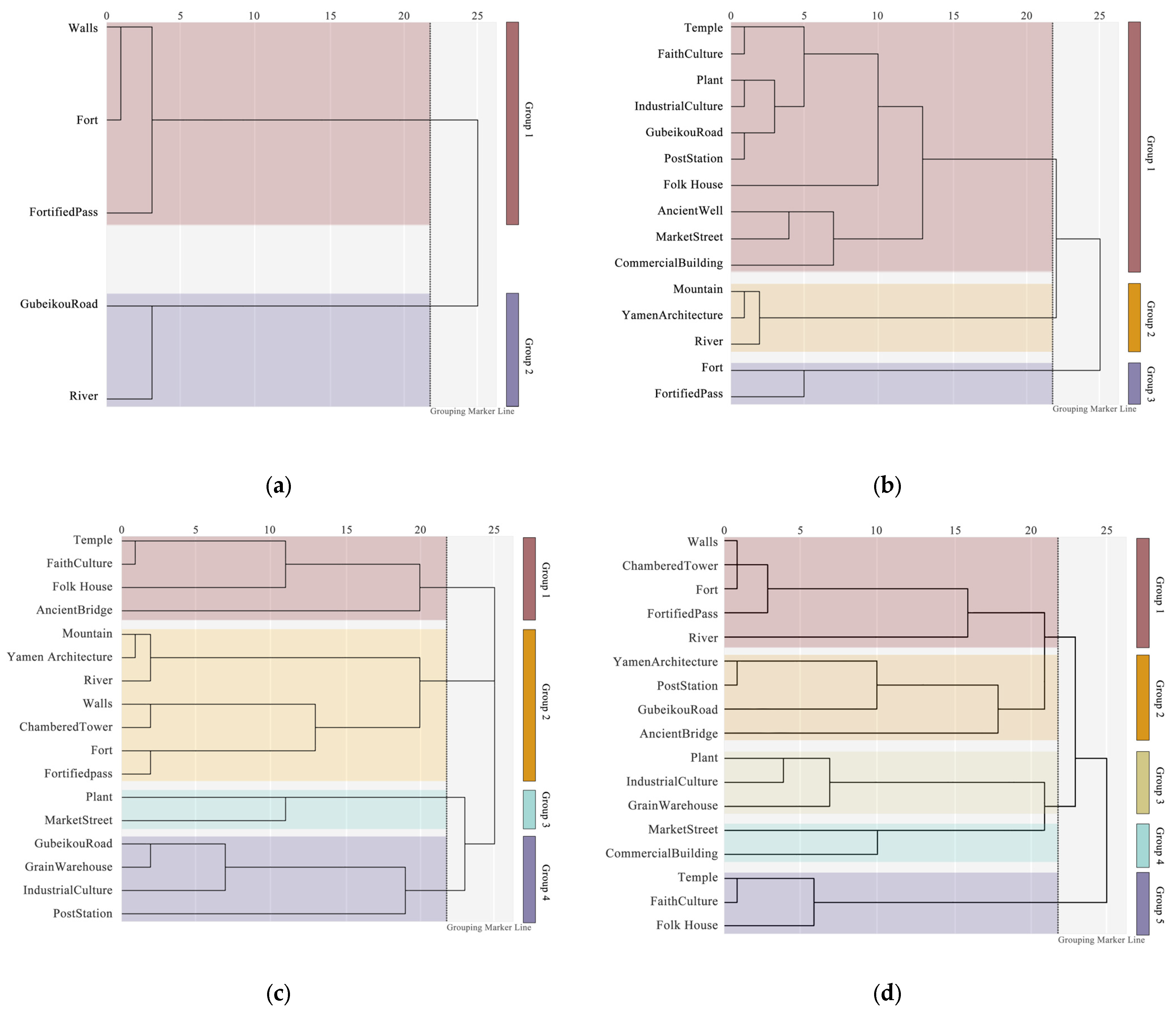
Results of PCA showed that the cumulative variance contribution rates of PC1 and PC2 in the following series of figures all exceeded 70%, indicating that these two principal components can explain the main influencing factors of the correlation characteristics among samples. To further explore the clustering characteristics of “landscape elements” under the influence of various key factors, the study conducted AHC on the data matrix using IBM SPSS Statistics v29.0. With Euclidean distance as the measurement metric, clustering analysis plots of “landscape elements” for each developmental period were generated. The results revealed that the clustering characteristics of landscape elements derived from AHC were highly consistent with those obtained from PCA (Figure 6).
Furthermore, by analyzing the distribution characteristics of objects in the figures and integrating historical events, the correlation characteristics between landscape elements and event types as well as their key influencing factors in each period were summarized (Table 6). From the results, it can be observed that in the Gubeikou region, from the “Military Embryonic Period” to the “Multi-Element Integration Period”, the key factors influencing the correlation characteristics between event types and landscape elements have exhibited an evolutionary trend of gradual diversification and continuous expansion of correlation dimensions, reflecting the cultural development characteristics of each period. Overall, the evolutionary laws of correlation characteristics in each period not only retained the continuity of core factors such as military affairs and transportation but also continuously integrated diverse elements including economy, culture, and folk customs with development, which reflects the dynamic evolutionary trajectory of the correlation between landscapes and events in the Gubeikou region.

3.2. Clustering Analysis of Event Types and Landscape Elements Based on PCA

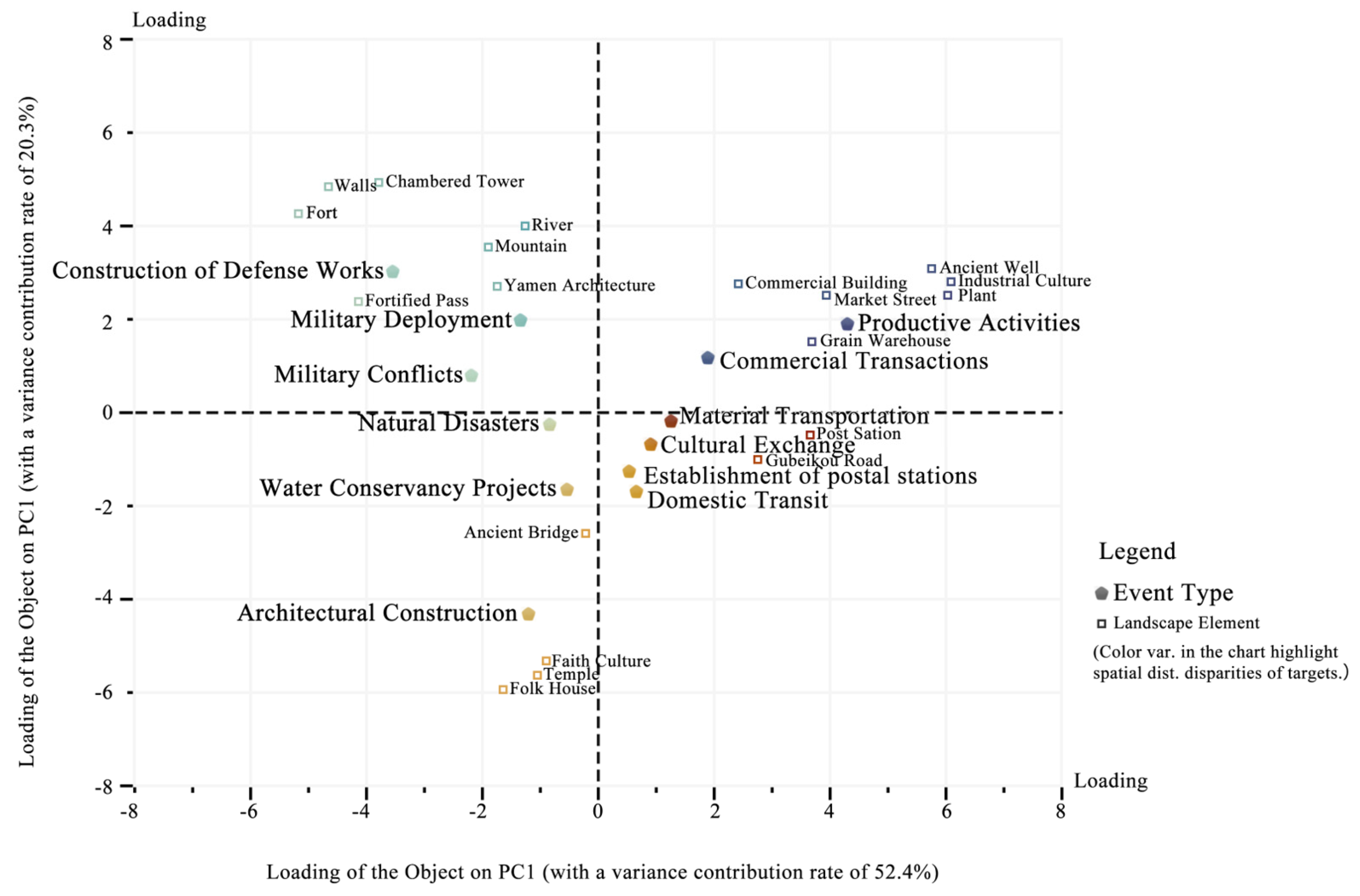
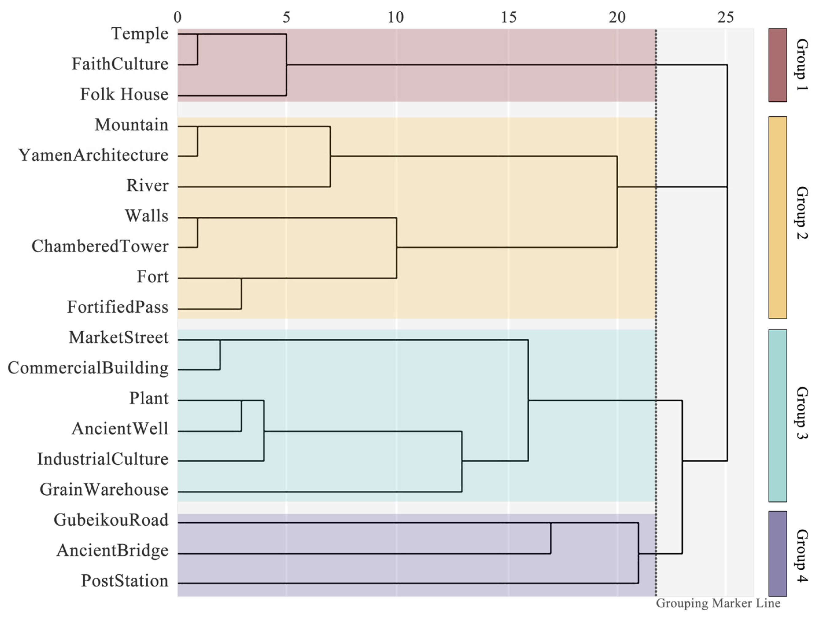
To identify the key influencing factors underlying landscape formation in the Gubeikou Town area throughout the entire historical period, this study took the types of historical events in the Gubeikou Town area as samples, and constructed a data matrix based on the historical co-occurrence frequencies of landscape elements with various event types. Subsequently, PCA was performed on the data (Figure 7) to analyze the correlation levels among the samples. Based on the distribution of samples across different quadrants in the figure, event types and landscape elements were categorized into 4 clusters. Meanwhile, using the same data matrix, AHC was conducted on the landscape elements for cross-validation, aiming to explore the correlation between specific influencing factors and their corresponding landscape element clusters (Figure 8). The key influencing factors are explained as follows:
  • Cluster 1 involves event types such as “Construction of Defense Works”, “Military Deployment”, and “Military Conflicts”, corresponding to landscape elements including “Fort”, “Walls”, “Chambered Tower”, “Yamen Architecture”, “Mountain”, and “River”. It is mainly affected by the role of military and political decisions based on the regional landscape pattern of mountains and rivers in shaping the landscape;
  • Cluster 2 includes event types such as “Material Transportation”, “Cultural Exchange”, “Establishment of postal stations”, and “Domestic Transit”, with landscape elements being “Post Station” and “Gubeikou Road”. It is mainly influenced by the regional transportation function;
  • Cluster 3 covers event types including “Commercial Transactions” and “Productive Activities”, with landscape elements such as “Commercial Building”, “Ancient Well”, “Market Street”, “Plant”, and “Industrial Culture”. It is mainly affected by industrial development activities;
  • Cluster 4 involves event types such as “Natural Disasters”, “Water Conservancy Projects”, and “Construction of ancestral temples”, corresponding to landscape elements including “Ancient Bridge”, “Faith Culture”, “Temple”, and “Residential Houses”. It is mainly influenced by local folk customs and construction activities.

3.3. Analysis of Types of Evolutionary Mechanisms of Landscape Patterns Driven by Historical Events

Based on the clustering results, the study divides the driving role of historical events in landscape evolution into four main types: “Evolution of Military Cultural Landscapes Dominated by Military and Political Activities, Evolution of Post Road Cultural Landscapes Driven by Transportation Activities, Evolution of Economic Cultural Landscapes Influenced by Production and Trade Activities, and Evolution of Folk Cultural Landscape Patterns Shaped by Construction Activities”. These types are elaborated by combining historical events and spatiotemporal distribution characteristics.

3.3.1. Type 1: Evolution of the Military Cultural Landscape Pattern Dominated by Military and Political Activities

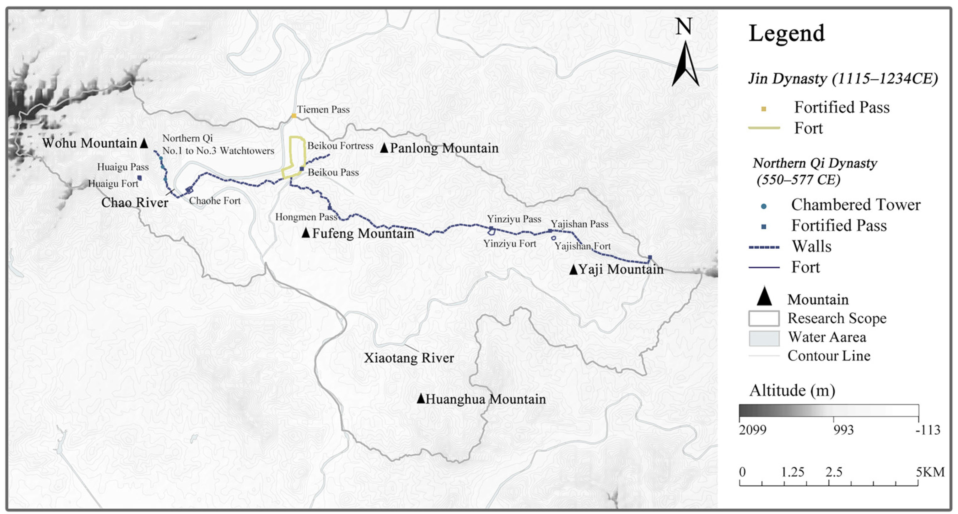
The impact of political and military activities on landscape formation is mainly reflected in two aspects: the construction of military defensive facilities based on strategic needs, and the establishment of local administrative agencies under the military system. On one hand, wars in the north prompted various dynasties to step up the construction of defensive facilities, forming a development context of “foundation laid in the Northern Qi Dynasty and systematization in the Ming Dynasty” (Figure 9 and Figure 10). On the other hand, the expansion of local military scale also brought pressure on social governance. The Tang Dynasty set up “Garrison-Towns” to manage local affairs while stationing troops; the Jin Dynasty built cities and set up customs offices to manage regional economic and trade circulation while guarding the border; the Ming Dynasty established the “Nine Frontier Garrisons” and ensured self-sufficiency in supplies for border troops through the Guard Post System; the Qing Dynasty set up agencies such as the Court of Colonial Affairs and Dusi Office to manage local military affairs.
In terms of spatiotemporal distribution, the pattern of Gubeikou’s military cultural landscape has shown an increasingly systematic evolutionary trajectory. The Northern Qi Dynasty took mountain ridges as the boundary, connecting Wohushan Mountain, Fufengshan Mountain, and Yajishan Mountain, forming a point-line defense pattern. The Jin Dynasty built cities north of the Northern Qi defense line to realize regional joint defense; the Ming Dynasty, to meet the needs of population and economic development, pushed the defense line northward, improved facilities, and built forts, forming a multi-level and multi-regional joint defense pattern; the Qing Dynasty added forts with functions of garrisoning, local governance, and overall military and political coordination, transforming from an enemy-defense barrier to a geopolitical support. This process fully demonstrates the systematic upgrading of the pattern from simplicity to complexity and the function from singularity to diversity.

3.3.2. Type 2: Evolution of Post Road Cultural Landscape Pattern Driven by Transportation Activities

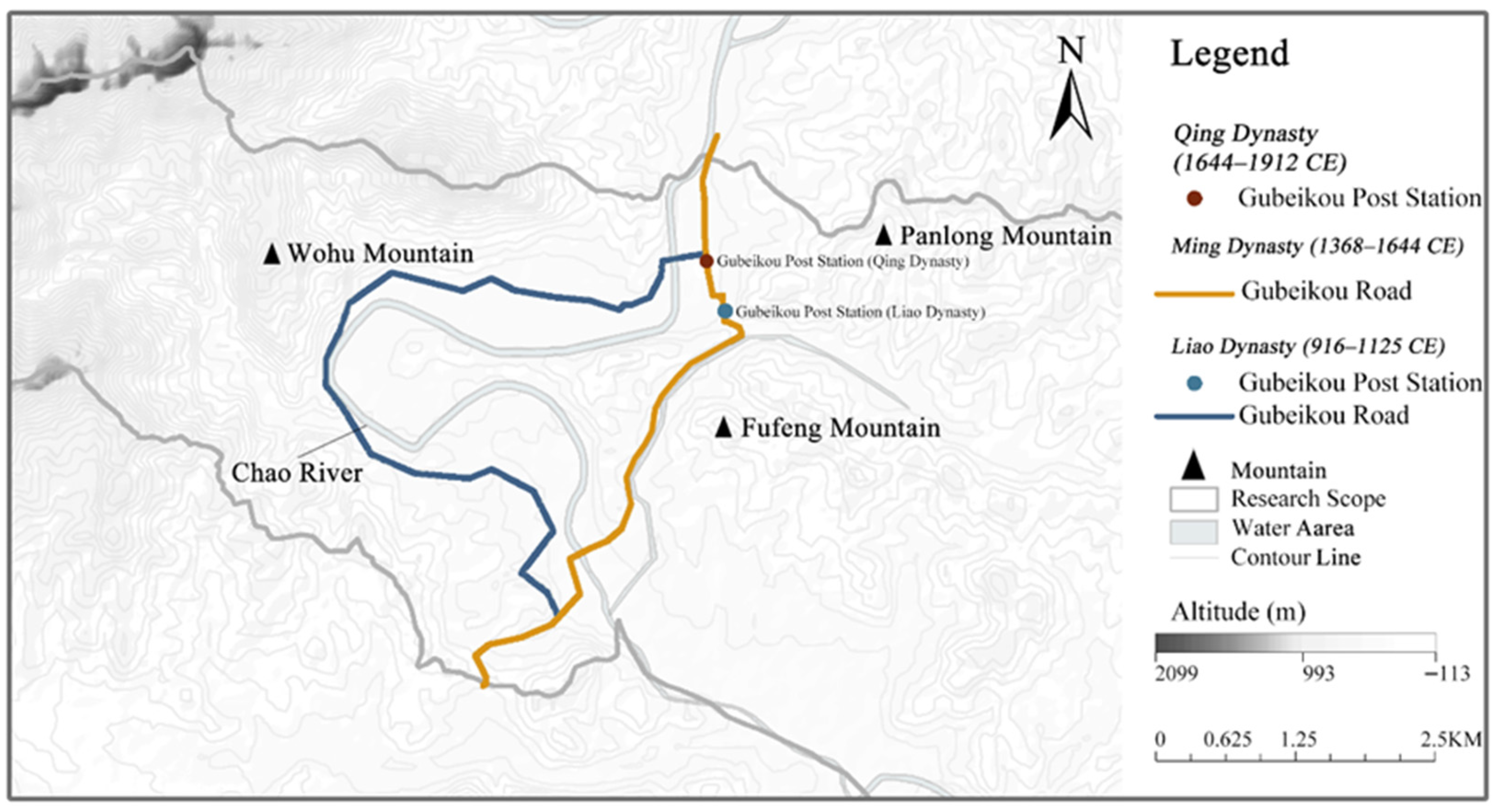
Transportation activities, based on the geographical conditions of Gubeikou, promoted exchanges between regimes and ethnic integration, and influenced the formation of Gubeikou’s landscape (Figure 11). As early as the Prehistoric Period, Gubeikou’s transportation attribute was already prominent; during the Liao and Song Dynasties, envoys between the Song and Liao Dynasties all passed through Gubeikou; the governments of the Liao, Jin, and Yuan Dynasties all established multiple capitals, and Gubeikou served as an important pass connecting these capitals; the Ming Dynasty established a military town and post road system, with the Gubeikou Post Road connecting the capital and border areas, undertaking the important tasks of document delivery and Material Transportation; the Qing Dynasty opened the Imperial Road to communicate with northern Mongolian tribes and maintain regime stability.
In terms of spatiotemporal distribution, the distribution of post-road cultural landscapes also considers military and political thoughts. Roads before the Ming Dynasty were located in natural low-lying valleys. When building the Gubeikou Fort in the Ming Dynasty, the mountain at the North Gate was excavated, changing the direction of the post road. In terms of the location of post stations, the Liao Dynasty post station sites were at a certain distance from the post road route and located within Beikou City, which was a consideration for military defense; the Qing Dynasty post stations were at the junction of two routes, within the scope of Gubeikou’s commercial markets and streets, reflecting the openness and prosperity of this period.

3.3.3. Type 3: Evolution of Economic Cultural Landscape Pattern Influenced by Productive and Trade Activities

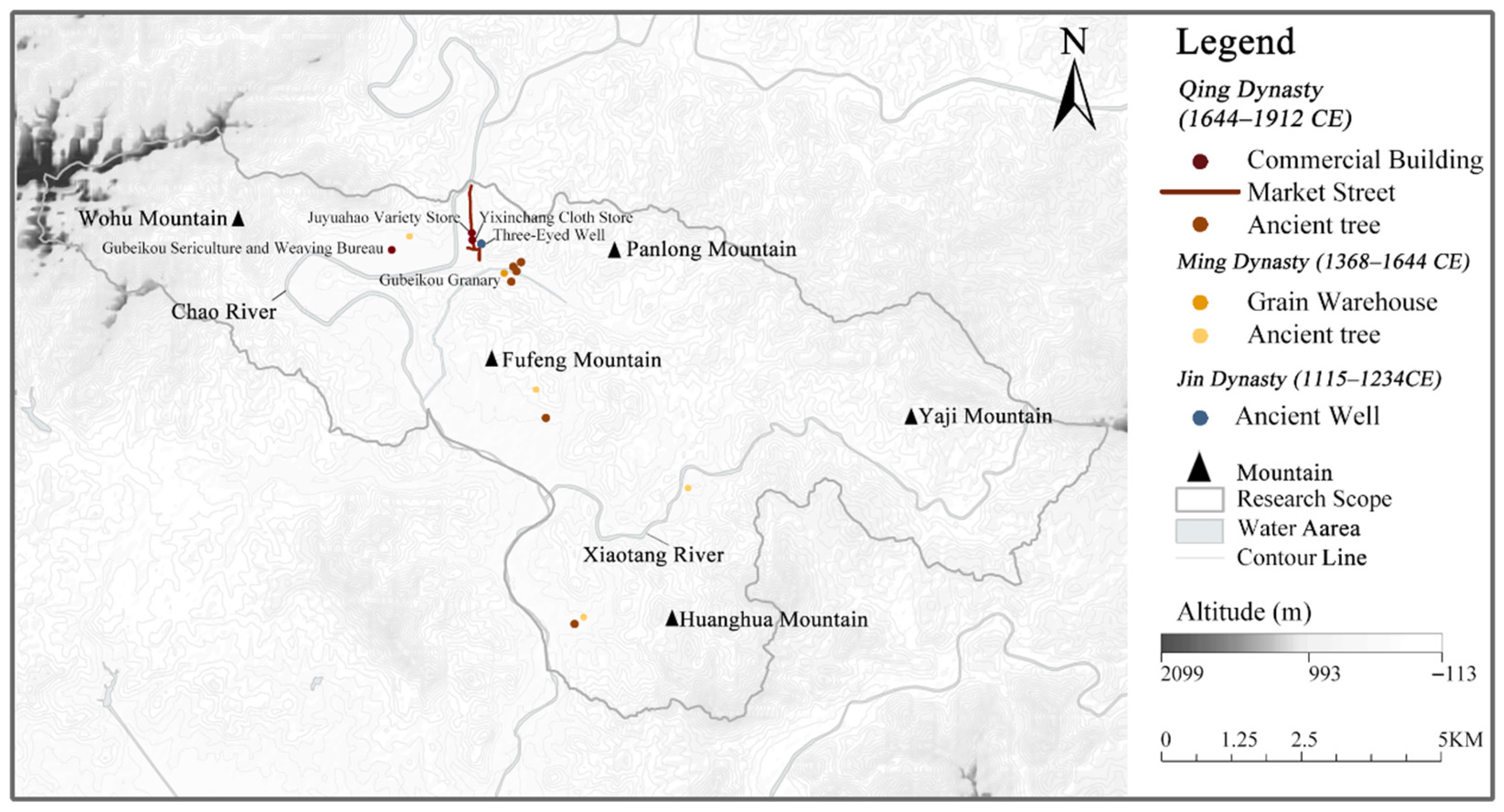
The influence of productive and trade factors runs through the entire development process of settlements. The industries in the Gubeikou region are rooted in agriculture, and have developed towards diversification with the change of dynasties (Figure 12). During the Tang Dynasty, agriculture flourished due to military farming; during the Five Dynasties and Ten Kingdoms Period, agriculture was damaged by wars. In the Liao Dynasty, the court encouraged farming, expanding the scale of agriculture. After the Treaty of Chanyuan, handicraft industry and commerce reached a climax, and Gubeikou became a regional commercial hub. The Ming Dynasty strengthened the military farming system, significantly expanding the scope of agricultural development; in the Qing Dynasty, under ethnic integration, agriculture, handicraft industry, mining industry, and breeding industry developed in parallel, and modern industry began to emerge. From the Tang Dynasty to the Qing Dynasty, the production form of Gubeikou gradually evolved from a military-driven single agriculture to an agricultural-industrial-commercial composite economic system.
In terms of spatiotemporal distribution, the industrial cultural landscape of Gubeikou presents the characteristics of “core agglomeration and peripheral radiation”. Hexi Village and Gubeikou Village preserve Grain Warehouse sites, Ancient Wells, and Market Streets, forming a dense belt of industrial cultural landscapes, highlighting their core status in production and trade; the ancient tree remains in other villages imply historical productive activities. The vegetation and cash crops around the landscape sites also witness the historical process of productive and trade activities in Gubeikou.

3.3.4. Type 4: Evolution of Folk Cultural Landscape Patterns Shaped by Construction Activities

According to historical records, construction activities in Gubeikou reflected social systems and cultural aspects (Figure 13). During the Song and Liao dynasties, the Liao government built Yang Linggong Temple here to send friendly signals to the Song government; envoys of the Song Dynasty recorded the scene of thatched cottages built for residence when passing through Gubeikou. In the early Ming Dynasty, when Xu Da built Gubeikou Fort, he constructed temples to promote ritual studies and built stone bridges for the convenience of the people. In the mid-Ming Dynasty, the Miyun Rear Guard was established; in addition, to strengthen the ideology of border people and maintain rule, Miyun Academic Office was built to teach Confucianism, and more temples were added. As seen in Stele Inscription of Guanwang Temple by Zhu Zeng, Principal Clerk of the Ministry of Justice in the Ming Dynasty (≪明刑部主事祝增关王庙碑记≫), a Secretary of the Ministry of Punishments of the Ming Dynasty (Jiajing 30th year), included in Miyun Gazetteer (≪密云县志≫) (Figure 14), the construction of buildings was inseparable from military culture and ritual beliefs.
In the late Ming and early Qing dynasties, frontier unrest led to intensified ethnic integration. During this period, buildings symbolizing various religions, such as Mosque, Yaowang Temple, and Guanyin Pavilion, were newly constructed, reflecting the diversity of people’s beliefs in Gubeikou at that time. In the mid-to-late Qing Dynasty, with social prosperity and stability, residents’ spiritual and material needs became increasingly rich, followed by more active construction of temples and residential buildings. Most of the existing residential heritage was built during this period.
It can be seen that the construction of these buildings was influenced by both military politics and regional culture. In the early stage, it mainly focused on meeting the military and political needs of maintaining border stability; in the later stage, due to ethnic integration, the growth of people’s spiritual needs, and pressure from local management, it shifted to responding to diverse social needs. This evolutionary process shows that Gubeikou’s folk culture evolved from singularity to diversity, and ritual activities transformed from single-function and spatially concentrated to multi-functional and spatially dispersed, eventually forming cultural landscapes carrying different historical imprints.

4. Discussion

4.1. Characteristics of the Evolutionary Mechanism of Cultural Landscapes in Military Settlements: A Case Study of Gubeikou

The evolutionary mechanism of military settlement landscapes exhibits significant differences from other settlement types [23,30,83,84,85]. Its core driving forces originate from geostrategic demands and military defense logic, which starkly differs from the development logic of commercial, agropastoral, or religious settlements (Table 7). Taking the Great Wall military settlement of Gubeikou as an example, its landscape evolution has consistently centered on “military defense” as the core axis. From the construction of the Great Wall in the Northern Qi Dynasty to the deployment of garrisons in the Ming Dynasty’s “Nine Frontier Garrisons,” the spatial distribution of landscape elements strictly adhered to the tactical principle of “easy to defend but difficult to attack,” forming a rigid coupling system of “landscape pattern—military facilities—military-administrative management.” This reflects an evolutionary logic absolutely dominated by military functions.
In terms of evolutionary rhythm and dynamic structure, military settlements such as Gubeikou are characterized by a strong “event-driven nature” and “phased abrupt changes” in their landscape iteration [86]—a feature rarely observed in other settlement types. Abrupt events like regime changes and wars often trigger drastic landscape reconstruction. For instance, after the “Gengxu Incident” in the Ming Dynasty, large-scale construction of military facilities and troop deployment were carried out in Gubeikou; in the mid-Ming Dynasty, Qi Jiguang led the large-scale construction of chambered towers, transforming the defense system from fragmented to systematic; in the Qing Dynasty, the policy-driven event of opening the “Imperial Road” directly converted Gubeikou from a military fortress into an economic hub, with significant development of industrial landscape elements. This “leapfrog evolution” triggered by military or political events is unique to military settlements. Therefore, understanding the landscape development of Gubeikou through historical events is of great significance [29], as it highlights the unique evolutionary mechanism of military settlements distinct from commercial, agropastoral, and religious settlements.
Table 7. Comparison of Characteristics and Development Mechanisms Across Different Types of Traditional Settlements.
Settlement NameSettlement TypeCore Driving FactorsSettlement Development Mechanism
Dongxi Ancient Town [3]Commerce; TransportationSalt trade, land-water transportationThe functional orientation shifted from being “military-dominated” in the early stage to “commerce-dominated” later.
Juuku/Kizil Suu Valleys [87]Agropastoralism; Ecological AdaptationAgropastoral development, ethnic migrationThe “agropastoral” function persisted throughout the settlement’s history, and immigration led to multi-ethnic cultural integration.
Settlements along the Ancient Tea Horse Road [88]Trade; TransportationCommercial trade, post road transportationThe development of the post road network, with “commerce” as its core function, persisted throughout; this network promoted cultural exchanges among different regimes.
Jiuguan Village (Shanxi) [89]Military; CommerceMilitary defense, commercial tradeThe dominant influencing factors underwent a transformation sequence of “military → commerce → military”.
Tibetan Traditional Villages in Western Sichuan [90]Religion; Ecological AdaptationTibetan Buddhism, plateau ecologyReligious culture persisted throughout the settlement’s development, and the plateau climate shaped the settlement’s morphology.
GubeikouPure Military DefenseGeostrategy, military policiesThe natural strategic pass established the settlement’s military status; military and political factors served as the main drivers, promoting the coordinated development of transportation, commerce, and folk customs.

4.2. Implications for Heritage Landscape Conservation and Adaptive Reuse Approaches Based on Historical Scenarios and Event Interpretation

4.2.1. Construct a Landscape System Conservation Framework

The evolution of Gubeikou’s material landscapes has always been a concrete projection of socio-cultural changes [18,28,51]—for instance, the Great Wall defense systems from the Northern Qi to the Ming Dynasty reflect the long-term confrontation between Central Plains dynasties and northern nomadic regimes, the rise of industrial landscapes in the Qing Dynasty embodies the transformation of social functions from a military frontier to an economic hub, and the evolution of Gubeikou Road from a post road to an imperial road carries the process of regime territory integration and in-depth ethnic exchanges [91]. This “material-culture” mapping is essentially the materialization of “collective memory” in different historical stages, with the continuity of landscape elements across dynasties making Gubeikou’s landscape pattern a concrete text recording the regional evolution from a military defense core to a multi-cultural hub. Against the current “preservation-development” tensions faced by Gubeikou as a living heritage (e.g., over-commercialization from cultural tourism and infrastructure expansion pressures from urbanization), we should construct a landscape system protection framework based on this evolutionary mechanism [26,31]: adhering to the logic of “core values retention + adaptive functional expansion,” we emphasize the authentic preservation of military landscapes to highlight regional historical and cultural themes, while promoting adaptive reuse of transportation, industrial, and architectural landscapes according to their respective functions, so as to balance cultural integrity and modern development.

4.2.2. Conservation Strategy Based on the Integrity of Historical Scenarios

Heritage protection in Gubeikou needs to strengthen the concept of “associative protection and systematic protection” to maintain the integrity of historical activity scenarios [92]. The protection of cultural landscapes should not view individual heritage sites such as walls and temples in isolation but rather conduct holistic protection by associating them with the spatial context of events such as “military defense” and “ritual activities.” On the one hand, it is necessary to study the joint expression between different cultural landscapes. For example, in the protection of military landscapes, it is important to both protect the fundamental role of the “landscape pattern” in forming the landscape structure and attach importance to the joint defense functions among various military facilities (Walls, Chambered Towers, Forts, Fortified Passes). Only through joint protection based on historical usage scenarios can their material form and cultural connotations be fully preserved [93,94]. On the other hand, for small-scale landscapes such as temples, which are often the only venues for ritual activities, their site characteristics (spatial sequences, perceptions, etc.) in the context of events should be fully protected. In short, the separation of cultural landscapes from historical scenarios due to isolated protection should be avoided. Such associative protection can transform heritage from static remains into a perceivable “theater of historical activities,” maintaining the scenario authenticity of landscape heritage [20].

4.2.3. Community-Participatory Heritage Reuse Model Based on Scenario Planning

In terms of utilization, the interpretation of historical events endows heritage with new value dimensions, while community engagement bridges historical memory and contemporary experience. Historical events in Gubeikou reflect traces of local community activities throughout history—such as war activities, production and living activities of military and civilian personnel, commercial and transportation activities, and ritual and sacrificial scenes—providing a unique interpretive perspective for cultural heritage [95,96]. As inheritors of local memory, modern residents participate in heritage interpretation through historical scenario reenactment: reenacting Liao-Song envoy exchanges or temple fair folk customs, serving as “heritage narrators” during tourism to share ancestral stories, and co-designing projects like seasonal folk markets on Market Street. This community involvement enhances the authenticity of interpretation, strengthens residents’ cultural identity, and transforms heritage into a living tradition, thus achieving synergy between protection, utilization, and community development [19,97].

4.2.4. Digital Display of Heritage Based on Historical Narrative

The core of this digital display lies in taking heritage’s historical context and event logic as anchors, breaking traditional display’s temporal–spatial limitations via digital technologies, and integrating “historical authenticity” with “experience innovation” [98]. Taking Gubeikou Great Wall military heritage as an example, a multi-level digital system can be built using its 302 historical events and 19 landscape element correlation data: it restores historical landscape patterns [99] (e.g., dynamically reproducing defensive works’ construction), enables audience “participation” in city defense or beacon communication via AR [100] to grasp heritage-event causal links, and designs a historical document interactive module to connect fragmented elements with records into a complete narrative chain.
This method preserves heritage’s core historical value while expanding experience dimensions, turning static sites into perceivable, participatory “living historical scenarios”. It deepens audiences’ understanding of heritage’s “event-element-value” correlation and provides a reusable digital pathway for living inheritance of similar heritages like Great Wall military settlements and ancient post roads.

4.3. Heritage Challenge Response Approaches Based on Landscape Evolution Mechanisms

4.3.1. Implications for Addressing Climate Disaster Threats to Heritage

The core value of landscape evolution mechanisms in addressing contemporary heritage challenges lies in revealing the long-term interaction laws between heritage elements, historical events, and external environments [101]. These laws provide targeted strategies for addressing climate change impacts, digital twin-based predictive conservation, and living heritage certification and crowdsourcing [102].
In terms of climate change, historical documents record information on natural disasters in Gubeikou since the Jin Dynasty, as well as the response measures of local residents and the government (e.g., military facilities of the Ming Dynasty were built on high ground to avoid floods, while the Qing Dynasty government constructed temporary grain warehouses to aid disaster victims). By integrating interdisciplinary perspectives such as eco-archeology and surveying and mapping, it is feasible to conduct zoning of climate-sensitive areas in the Gubeikou region and implement ecological restoration aligned with historical vegetation patterns. For digital twin protection, historical records offer crucial data for studying the historical laws of natural disaster occurrences, injecting a “temporal dimension” into twin models and supporting trend simulation and authenticity verification of restoration.

4.3.2. Guide the Establishment of a Crowdsourced Heritage Management Model in the Gubeikou Region

This collaboration-driven certification framework [103] rooted in landscape evolution mechanisms enables a dynamic certification process that goes beyond static documentation—one that bears witness to the historical activities of their ancestors in this region, embodies the folk spirit and ideology of community residents, and shapes the identity of relevant stakeholders [104]. This understanding facilitates the development of a crowdsourced heritage management model in the Gubeikou Region, guiding residents in their transition from bystanders to narrators and custodians of landscape evolution narratives; meanwhile, it promotes active exploration of collaboration with social professionals. Based on this cognitive framework, a sound collaborative heritage management model between communities and society can be established, facilitating the sustainable development of heritage.
In summary, landscape evolution mechanisms transform historical laws into actionable tools. By drawing on historical adaptability, embedding evolutionary logic into digital twins, and inheriting the multi-stakeholder collaboration model, heritage response measures strike a balance between technological advancement and historical roots, achieving the unity of heritage “sustainable conservation” and “future adaptability.”

5. Conclusions

This study validates the evolutionary mechanism of Gubeikou’s cultural landscape by systematically sorting 302 historical events into 12 types and 19 landscape elements, constructing a co-occurrence frequency matrix and using PCA and AHC to cluster them with historical-geographical data. Key findings reveal four evolutionary stages (military embryonic, functional expansion, system maturity, multi-element integration), a dynamic trajectory where cultural landscape evolution is driven by core factors like military and transportation while integrating economic, cultural, and folk elements, and a “primary–secondary synergy” dynamic structure formed by military–political, transportation, production–trade, and construction activities—all shaped by the coupling of political goals, social operations, and geographical conditions. This framework not only uncovers the composite evolutionary characteristics of Gubeikou’s landscape but also provides a methodological reference for heritage protection and regional studies.
While this study constructs a quantitative framework for historical events and analyzes the impacts of these events on cultural landscapes, two key limitations warrant further discussion. First, the depth of quantification for historical activities remains insufficient—due to the lack of granular details (e.g., event intensity, spatial scope of influence) in historical records, it remains challenging to differentiate the nuanced impacts of homologous events on landscape formation. Second, beyond the macro-narrative bias and subjective sentiments inherent in dynastic documents noted earlier, this study also overlooks the systematic critique of data representativeness—for instance, the scarcity of content related to minority or gender perspectives in government archives and event databases. As emerging heritage studies emphasize, multiperspective narratives are crucial for comprehensive landscape interpretation; however, the current framework relies primarily on historical records of the elite class, sidelining the voices of women, ethnic minorities, and non-state actors.
This oversight stems from two interrelated gaps: (1) the event database prioritizes official chronicles while downplaying grassroots materials (e.g., clan genealogies, oral histories)—the latter often preserve the perspectives of marginalized groups; (2) the research framework lacks mechanisms to account for gendered landscape practices (e.g., the historical roles of women, children, and the elderly in landscape shaping). Future research should address these issues by: (1) integrating multi-source data (archival records, archeological reports, oral histories) to construct an inclusive event database; (2) developing analytical frameworks sensitive to gender and minority perspectives—for example, mapping heritage practices led by women alongside military construction events; (3) establishing an interdisciplinary credibility evaluation system that conducts triangulation of documentary evidence with archeological and anthropological data. Such advancements will not only enhance the objectivity of landscape evolution research but also align it with the contemporary heritage field’s call for decolonized and inclusive narratives.

Author Contributions

Author Contributions: Conceptualization, H.D. and D.H.; Data curation, D.H. and H.D.; Formal analysis, H.D., D.H. and S.L.; Investigation, H.D., D.H. and M.F.; Methodology, H.D. and D.H.; Project administration, H.D. and D.H.; Resources, H.D., S.L. and M.F.; Software, D.H. and H.D.; Supervision, H.D.; Validation, H.D., D.H. and S.L.; Visualization, H.D., D.H. and M.F.; Writing—original draft, H.D. and D.H.; Writing—review and editing, H.D., D.H., S.L. and M.F. All authors have read and agreed to the published version of the manuscript.

Funding

This research was funded by the China National Natural Science Foundation, with grant numbers 52378002 and 52178029.

Data Availability Statement

The original contributions presented in the study are included in the article, further inquiries can be directed to the corresponding author/s.

Conflicts of Interest

The authors declare no conflicts of interest.

References

  1. Li, H.P.; Xiao, J. Analysis on the types and composing of cultural landscapes of China. Chin. Landsc. Archit. 2009, 25, 90–94. [Google Scholar]
  2. Li, H.P.; Xiao, J.; Cao, K.; Xing, X.L. Exploration of the historical towns’ living protection method through the co-evolution of “landscape-culture”. Chin. Gard. 2015, 31, 68–73. [Google Scholar]
  3. Ma, X.; Sun, J. A study of historic urban landscape change management based on layered interpretation: A case study of dongxi ancient town. Land 2024, 13, 2116. [Google Scholar] [CrossRef]
  4. Yang, Q. Research on the changes in cultural landscape of tourist-type traditional Chinese villages from the perspective of cultural memory: Taking Anzhen village in Chongqing as an example. Land 2023, 12, 816. [Google Scholar] [CrossRef]
  5. Wang, L.S.; Jin, Y.P. Linear cultural concept: The practice and structural transformation of urban cultural heritage protection and utilization—Focusing on Beijing’s “three cultural zones”. J. Beijing Union Univ. Humanit. Soc. Sci. Ed. 2021, 19, 16–24. [Google Scholar]
  6. Han, G.H.; Li, X.F. The formation and development of settlements along the great wall in the Beijing area. In Proceedings of the Great Wall International Academic Symposium, Beijing, China, 22–24 September 1994. [Google Scholar]
  7. Huizi, Z.; Sicheng, H.; Chengzhi, R.; Yunlu, Z. Construction of the great wall cultural heritage landscape system from the perspective of regional synergy. J. Chin. Urban For. 2020, 18, 126–130. [Google Scholar]
  8. Li, Y. Research on the Military Fortresses and Settlements of the Great Wall in Yulin Region. Master’s Thesis, Tianjin University, Tianjin, China, 1 March 2004. [Google Scholar]
  9. Zhang, B.X. “The key to the north of Beijing”—The historical evolution of gubeikou. J. Beijing Union Univ. 1998, 3, 7–12. [Google Scholar]
  10. Jiang, T. The roads in the capital of the qing dynasty and the imperial roads for the emperor’s inspection tours. North. Cult. 1991, 72–78. [Google Scholar] [CrossRef]
  11. Wei, S.P. The function of the ancient beikou during the liao dynasty. J. Liaoning Tech. Univ. Soc. Sci. Ed. 2016, 18, 447–450. [Google Scholar]
  12. Zhou, F. The ancient beikou during the liao and jin dynasties. J. Liaoning Tech. Univ. Soc. Sci. Ed. 2000, 4, 38–41. [Google Scholar]
  13. Hou, R. An Historical Geography of Peiping; Springer: Berlin/Heidelberg, Germany, 2014. [Google Scholar]
  14. UNESCO. Operational Guidelines for the Implementation of the World Heritage Convention (WHC.25/01); UNESCO: Paris, France, 16 July 2025. [Google Scholar]
  15. Ireland, T.; Brown, S.; Bagnall, K.; Lydon, J.; Sherratt, T.; Veale, S. Engaging the everyday: The concept and practice of ‘everyday heritage’. Int. J. Herit. Stud. IJHS 2025, 31, 192–215. [Google Scholar] [CrossRef]
  16. Pintér, M.H. When immovable heritage goes ambulatory: The sheep dyke of north ronaldsay (orkney) as an ‘organically evolving monument’. Int. J. Herit. Stud. IJHS 2025, 31, 1138–1156. [Google Scholar] [CrossRef]
  17. Sehlikoglu, S. Inheritance without the heritage: Fig trees and the ecological effects of imaginative attachments to fetih (conquest). Int. J. Herit. Stud. IJHS 2025, 31, 1207–1225. [Google Scholar] [CrossRef]
  18. Tang, C.; Qiu, T.; Li, Y. Heritage perspectives on cultural memory and spatial identity in yuan river basin, Hunan, China. npj Herit. Sci. 2025, 13, 261. [Google Scholar] [CrossRef]
  19. Cheng, Y.; Fei, X.; Luo, L.; Kong, X.; Zhang, J. Social network analysis of heterogeneous subjects driving spatial commercialization of traditional villages: A case study of tanka fishing village in lingshui li autonomous county, China. Habitat Int. 2025, 155, 103235. [Google Scholar] [CrossRef]
  20. Yuan, L.; Xu, L.; Zhang, Z.; Xu, Y. Traditional village clustered protection and utilization methods based on network science. npj Herit. Sci. 2025, 13, 140. [Google Scholar] [CrossRef]
  21. Mišić, S.; Obradović, M. Geometry of bastion fortifications magistral line: Influences and development. npj Herit. Sci. 2025, 13, 12. [Google Scholar] [CrossRef]
  22. Wang, W.; Shi, Q.; Wang, G. Exploration of the landscape gene characteristics of traditional villages along the jinzhong section of the wanli tea road from the perspective of the village temple system. Land 2024, 13, 1602. [Google Scholar] [CrossRef]
  23. Chen, H.; Xiao, D.; Li, J.; Liu, Y. Study on the distribution characteristics and formation mechanism of traditional village names in southeast Guizhou. npj Herit. Sci. 2025, 13, 263. [Google Scholar] [CrossRef]
  24. Sun, J.; Shao, L. Interpretation of historic urban landscape genes: A case study of Harbin, China. Land 2024, 13, 1988. [Google Scholar] [CrossRef]
  25. Xia, R.; Genovese, P.V.; Li, Z.; Zhao, Y. Analyzing spatiotemporal features of Suzhou’s old canal city: An optimized composite space syntax model based on multifaceted historical-modern data. Herit. Sci. 2024, 12, 391. [Google Scholar] [CrossRef]
  26. Zhang, Y.; He, Y. Human-land relationship in the construction of historical settlements based on complex adaptive system (CAS) theory: Evidence from Shawan in Guangfu region, China. Herit. Sci. 2024, 12, 173. [Google Scholar] [CrossRef]
  27. Lei, Z.; Li, J. Genotype extraction of traditional dwellings using space syntax: A case study of Tibetan rural houses in Ganzi county, China. npj Herit. Sci. 2025, 13, 13. [Google Scholar] [CrossRef]
  28. Wang, F.; Zhang, T.; Zhang, S. MGWR reveals scale heterogeneity shaping intangible cultural heritage distribution in China. npj Herit. Sci. 2025, 13, 367. [Google Scholar]
  29. Yuan, L.; Li, Z.; Wang, Y.; Hao, Z.; Yu, C. Interactions between the ming yansui great wall heritage and geographical environment via monte carlo simulation. npj Herit. Sci. 2025, 13, 260. [Google Scholar]
  30. Gao, S.; Wang, J.; Liu, S.; Xu, X.; Liao, Y.; Zhang, Z.; Sun, T. Spatio-temporal evolution characteristics and influencing factors of traditional villages in the Qiantang river basin based on historical geographic information. npj Herit. Sci. 2025, 13, 134. [Google Scholar] [CrossRef]
  31. Chen, J.; Zhao, X.; Wang, H.; Yan, J.; Yang, D.; Xie, K. Portraying heritage corridor dynamics and cultivating conservation strategies based on environment spatial model: An integration of multi-source data and image semantic segmentation. Herit. Sci. 2024, 12, 419. [Google Scholar] [CrossRef]
  32. Cao, K.; Liu, Y.; Cao, Y.; Wang, J.; Tian, Y. Construction and characteristic analysis of landscape gene maps of traditional villages along ancient qin-shu roads, western China. Herit. Sci. 2024, 12, 37. [Google Scholar]
  33. Leong, A.M.W.; Yeh, S.; Zhou, Y.; Hung, C.; Huan, T. Exploring the influence of historical storytelling on cultural heritage tourists’ value co-creation using tour guide interaction and authentic place as mediators. Tour. Manag. Perspect. 2024, 50, 101198. [Google Scholar] [CrossRef]
  34. Gil Hernández, R. Towards other-heritagisation: Negativity in heritage beyond appropriation, maintenance, and transmission. Int. J. Herit. Stud. IJHS 2025, 1–21. [Google Scholar] [CrossRef]
  35. Horský, J.; Ovčáčková, L. Symbolic centres: Cultural transfer in the forcibly abandoned czech borderlands. Int. J. Herit. Stud. IJHS 2024, 1–16. [Google Scholar] [CrossRef]
  36. Ristiawan, R.R.; Sushartami, W. Political reconciliation and emancipatory reinterpretations of jakarta’s pancasila sakti monument through heritage tourism: An exploratory study. Int. J. Herit. Stud. IJHS 2025, 1–18. [Google Scholar] [CrossRef]
  37. Bartley, I. It’s not just a game: Playing selected modern board games as a decolonising tool in museums through participatory action research. Int. J. Herit. Stud. IJHS 2025, 1–20. [Google Scholar] [CrossRef]
  38. Yi, C.; Huang, J.; Song, L. Enhancing intangible cultural heritage dissemination through digital experience: An affective events theory approach. Herit. Sci. 2025, 13, 438. [Google Scholar]
  39. Vuoto, A.; Funari, M.F.; Karimzadeh, S.; Lourenço, P.B. Generative modelling of monopteros and tholos temples using existing data: The case study of vesta temple in tivoli. J. Cult. Herit. 2025, 71, 334–345. [Google Scholar]
  40. Li, J.; Xu, T.; Gu, X.; Lin, J.; Li, M.; Tao, P.; Dong, X.; Yao, P.; Shao, M. Scene clusters, causes, spatial patterns and strategies in the cultural landscape heritage of tang poetry road in eastern Zhejiang based on text mining. Herit. Sci. 2023, 11, 212. [Google Scholar] [CrossRef]
  41. Chen, Y.; Dong, Q.; Zhang, L.; Shao, L.; Tang, Y. Using natural language processing to identify and evaluate heritage value for buffer zone delineation in Hengdaohezi town. npj Herit. Sci. 2025, 13, 262. [Google Scholar] [CrossRef]
  42. González-Cantera, T.; Bonacchi, C. Chatgpt’s interpretation of contested memoryscapes favours the voice of current governments, capitalism and the far-right. Int. J. Herit. Stud. IJHS 2025, 1–23. [Google Scholar]
  43. Colace, F.; Gaeta, R.; Lorusso, A.; Pellegrino, M.; Santaniello, D. New ai challenges for cultural heritage protection: A general overview. J. Cult. Herit. 2025, 75, 168–193. [Google Scholar]
  44. Fu, J.; Chen, K.; Qin, J.; Yang, L.; Liu, P.; Zheng, W. Historical geographical information system (HGIS): Social trajectories of two Chinese historical figures Su Shi and Zuo Zongtang in spatial context. Herit. Sci. 2024, 12, 357. [Google Scholar]
  45. Ceng, R.; Cheng, Y.H. Research on spatial narrative construction of industrial heritage from the perspective of urban renewal—A case study of Tongguanshan 1978 cultural and creative park. J. Disaster Prev. Mitig. Eng. 2024, 44, 1275–1285. [Google Scholar]
  46. Zhang, W.; Wang, Y.; Fu, L.; Hu, Y. Scenery deconstruction: A new approach to understanding the historical characteristics of Nanjing cultural landscape. Herit. Sci. 2024, 12, 62. [Google Scholar] [CrossRef]
  47. Xi, X.; An, X.; Zhang, G.; Liang, S. Spatial patterns, causes and characteristics of the cultural landscape of the road of tang poetry based on text mining: Take the road of tang poetry in eastern Zhejiang as an example. Herit. Sci. 2022, 10, 129. [Google Scholar] [CrossRef]
  48. Cui, Y.; Yao, S.; Wu, J. A network analytical framework for modeling the global transmission of classics through translation. npj Herit. Sci. 2025, 13, 338. [Google Scholar] [CrossRef]
  49. Dragutinovic, A.; Kost, S. (Dis-)continuation of territoriality: A framework for analysis of the role of social practices in (re-)production of space. Land 2025, 14, 229. [Google Scholar] [CrossRef]
  50. Lai, L.W.C.; Davies, S.N.G.; Leung, N.T.H.; Lau, P.L.K.; Kee, T. Remembering walls by map naming and planned attempts to eradicate and salvage a wall-less “walled city”: Kowloon city. Land Use Policy 2025, 148, 107375. [Google Scholar] [CrossRef]
  51. Qiu, B.; Song, P.; Tao, X.; Zhou, Q.; Zhang, F. Construction of urban collective memory maps based on social media data: A case study of Nanjing, China. npj Herit. Sci. 2025, 13, 259. [Google Scholar] [CrossRef]
  52. Xu, D.; Zhu, J.; Chen, Z. Identifying the authenticity of plantscapes through classics: A case study of Beijing suburbs in the qing dynasty. Land 2024, 13, 1171. [Google Scholar] [CrossRef]
  53. Li, W.; Chen, S.; Cui, Y.; Lin, H.; Lv, H.; Ao, J. Academy, private school, confucius institute: Analyzing heritage art of educational architectural paintings via event coding. npj Herit. Sci. 2025, 13, 340. [Google Scholar] [CrossRef]
  54. Li, W.; Xie, Q.; Shi, W.; Lin, H.; He, J.; Ao, J. Cultural rituality and heritage revitalization values of ancestral temple architecture painting art from the perspective of relational sociology theory. Herit. Sci. 2024, 12, 340. [Google Scholar] [CrossRef]
  55. Li, Y.; Zhang, Y.K.; Li, Z. Research on the defense system and military settlements of the ming great wall. Archit. J. 2018, 3, 69–75. [Google Scholar]
  56. Cao, Y.; Zhang, Y. Efficient space and resource planning strategies: Treelike fractal traffic networks of the ming great wall military defence system. Ann. GIS 2018, 24, 47–58. [Google Scholar] [CrossRef]
  57. Lin, F.; Zhang, X.; Ma, Z.; Zhang, Y. Spatial structure and corridor construction of intangible cultural heritage: A case study of the ming great wall. Land 2022, 11, 1478. [Google Scholar] [CrossRef]
  58. Zhao, S.; Yang, D.; Gao, C. Identifying landscape character for large linear heritage: A case study of the ming great wall in ji-town, China. Sustainability 2023, 15, 2615. [Google Scholar] [CrossRef]
  59. He, D.; Chen, W.; Zhang, J. Integrating heritage and environment: Characterization of cultural landscape in Beijing great wall heritage area. Land 2024, 13, 536. [Google Scholar] [CrossRef]
  60. Wang, F.; Xu, Y.; Zhao, Y.; Zhu, X. Belt or network? The spatial structure and shaping mechanism of the great wall cultural belt in Beijing. J. Mt. Sci. 2018, 15, 2027–2042. [Google Scholar] [CrossRef]
  61. Su, M.M.; Wall, G. Global–local relationships and governance issues at the great wall world heritage site, China. J. Sustain. Tour. 2012, 20, 1067–1086. [Google Scholar] [CrossRef]
  62. Yang, Y.; Zhang, Y.; Li, Y. Temporal and spatial distribution characteristics of the ming great wall. Herit. Sci. 2024, 12, 81. [Google Scholar]
  63. Wang, Z.Y.; He, D.; Zhang, J. Study on the Scale and Morphological Types of Great Wall Castle Settlements in Miyun, Beijing. Des. Community 2021, 64–68. [Google Scholar]
  64. Zheng, W.L. Landscape Pattern and Spatial Analysis of Military Settlements Below the Great Wall—Taking the Great Wall at Gubeikou as an Example. Master’s Thesis, Tianjin University, Tianjin, China, 30 March 2022. [Google Scholar]
  65. Tian, S.; Ma, W.R. Multidisciplinary integration of ming great wall resources and the construction of great wall studies. Res. Great Wall Stud. 2022, 56, 3–17. [Google Scholar] [CrossRef]
  66. Xue, L.P.; Zhou, Z.N.; Zheng, Y.Y. The Study on the Historic and Cultural Town of Gubeikou in Miyun County, Beijing. Beijing Plan. Rev. 2014, 112–120. [Google Scholar]
  67. Wang, Z.; Zhang, C.; Lang, Q.; Jin, L.; Qi, H. HUNet: Hierarchical universal network for multi-type ancient Chinese character recognition. Herit. Sci. 2025, 13, 281. [Google Scholar] [CrossRef]
  68. Weber, R.P. Basic Content Analysis; Sage: London, UK, 1990. [Google Scholar]
  69. Choi, C.; Lee, J.; Machado, J.; Kim, G. Big-data-based text mining and social network analysis of landscape response to future environmental change. Land 2022, 11, 2183. [Google Scholar]
  70. Huda, I.A.I.S.; Utaya, S.; Bachri, S.; Sumarmi, S.; Sagala, I. Local customary law: The contribution of cuci kampung tradition as counterforce to territorial stigmatization in Jambi, Indonesia. Humanit. Soc. Sci. Commun. 2025, 12, 1396. [Google Scholar] [CrossRef]
  71. Shen, S.; Zhao, Z.; Yan, D.; Jiang, C.; Wang, D. HsscBERT: Pre-training domain model for the full text of Chinese humanity and social science. npj Herit. Sci. 2025, 13, 229. [Google Scholar] [CrossRef]
  72. Maxqda. Available online: https://www.maxqda.com/ (accessed on 3 July 2025).
  73. Jolliffe, I. Principal component analysis. In International Encyclopedia of Statistical Science; Springer: Berlin/Heidelberg, Germany, 2011; pp. 1094–1096. [Google Scholar]
  74. Murtagh, F.; Contreras, P. Algorithms for hierarchical clustering: An overview. Wiley Interdiscip. Rev. Data Min. Knowl. Discov. 2012, 2, 86–97. [Google Scholar] [CrossRef]
  75. Sima, Q.; Ban, G.; Chen, S.; Ouyang, X.; Fang, X.; Fan, Y.; Shen, Y.; Liu, X.; Wei, Z.; Wei, S.; et al. Twenty-Four Histories; Zhonghua Book Company: Beijing, China, 1997. [Google Scholar]
  76. He, B.S. Historical Records of the Great Wall in the Ming Dynasty Veritable Records; Beijing Yanshan Publishing House: Beijing, China, 2014. [Google Scholar]
  77. Huang, Z.J. The Veritable Records of the Ming Dynasty; Zhonghua Book Company: Beijing, China, 2015. [Google Scholar]
  78. Zhonghua Book Company, The Veritable Records of the Qing Dynasty; Zhonghua Book Company: Beijing, China, 1985.
  79. Zong, Q.X. The Chronicles of Miyun County in the Republic of China; The Chronicles of Miyun County in the Republic of China: Beijing, China, 2009. [Google Scholar]
  80. China Bookstore, Revised Edition of Miyun County Annals in the Guangxu Reign; China Bookstore: Beijing, China, 2023.
  81. Xiao, J.; Cao, K. Research on historical town preservation methods based on the “narrative grammar” and “accumulation mechanism” of landscapes. Zhong Guo Yuan Lin 2016, 32, 20–26. [Google Scholar]
  82. Zoran, G. Towards a theory of space in narrative. Poet. Today 1984, 5, 309–335. [Google Scholar] [CrossRef]
  83. Zhang, W.; Lin, Z.; Zhang, G.; Jiang, L.; Chen, M.; Zhou, S.; Zhang, Y.; Zhao, X. Microscale fluvial landscape evolution and its impacts on early human settlement at the shangshan cultural site in the upper Qiantang region, eastern China. Geomorphology 2025, 473, 109630. [Google Scholar] [CrossRef]
  84. Duan, Y.; Chen, M.; Liu, Y.; Wang, Y.; Zhang, L. Research on the cultural landscape features and regional variations of traditional villages and dwellings in multicultural blending areas: A case study of the jiangxi-anhui junction region. Appl. Sci. 2025, 15, 2185. [Google Scholar] [CrossRef]
  85. Li, J.; Xiao, Y.; Yan, J.; Liang, C.; Zhong, H. Spatiotemporal evolution characteristics and causative analysis of toponymic cultural landscapes in traditional villages in northern Guangdong, China. Sustainability 2025, 17, 271. [Google Scholar] [CrossRef]
  86. Bai, J.; Bian, J.; Wang, Z.; Yuan, S.; Mu, N.; Xiao, T. Resource supply and demand model of military settlements in the cold weapon era: Case of Zhenbao town, ming great wall. Herit. Sci. 2024, 12, 318–389. [Google Scholar] [CrossRef]
  87. Chang, C.; Ivanov, S.S.; Tourtellotte, P.A.; Spengler, R.N.; Mir-Makhamad, B.; Kramar, D. Ancient agricultural and pastoral landscapes on the south side of lake issyk-kul: Long-term diachronic analysis of changing patterns of land use, climate change, and ritual use in the juuku and kizil suu valleys. Land 2022, 11, 902. [Google Scholar] [CrossRef]
  88. Zeng, Z.; Shen, C.; Xu, M. Historical insights into sustainable development: Analyzing the spatiotemporal dynamics of ancient trade and settlements. Land 2024, 13, 701. [Google Scholar] [CrossRef]
  89. Lin, Z.; Liang, Y.; Liu, X. Study on spatial form evolution of traditional villages in jiuguan under the influence of historic transportation network. Herit. Sci. 2024, 12, 29. [Google Scholar] [CrossRef]
  90. Fan, D.; Maliki, N.Z.B.; He, C.; Bi, Y.; Yu, S. Cultural gene characterization and mapping of traditional tibetan village landscapes in western Sichuan, China. npj Herit. Sci. 2025, 13, 317. [Google Scholar] [CrossRef]
  91. Gong, L.; Greenop, K.; Keys, C.; Landorf, C. Digital reconstruction and representation of the sino-korean tribute routes using geographic information systems. Herit. Sci. 2025, 13, 163. [Google Scholar] [CrossRef]
  92. He, D.; Hu, J.; Zhang, J. Assessment of sustainable development suitability in linear cultural heritage—A case of Beijing great wall cultural belt. Land 2023, 12, 1761. [Google Scholar] [CrossRef]
  93. Fan, X.; Wang, Z.; Li, S. Value evaluation model (VEM) of ancient Chinese military settlement heritage: A case study of liaoxi corridor in the ming dynasty. Herit. Sci. 2024, 12, 15–97. [Google Scholar]
  94. Howell, K.L.; Gough, M.Z.; Cameron, H.M. “Why are we asking for a seat at the table that our ancestors created for us?” the importance of cultural landscapes and power in urban planning. J. Urban Aff. 2025, 47, 1–22. [Google Scholar] [CrossRef]
  95. Song, H.; Chen, J.; Li, P. Decoding the cultural heritage tourism landscape and visitor crowding behavior from the multidimensional embodied perspective: Insights from Chinese classical gardens. Tour. Manag. 2025, 110, 105180. [Google Scholar] [CrossRef]
  96. Shen, J.; Li, Y.; Wang, Y. Nesting landscape character and personality assessment to intensify rural landscape regionality and uniqueness. Environ. Impact Assess. Rev. 2025, 110, 107705. [Google Scholar]
  97. Bohnet, I.C.; Bryce, R.; Måren, I.E.; Barraclough, A.D.; Malcolm, Z.; Külm, S.; Kokovkin, T.; Taylor, S.; Cudlinova, E.; Sepp, K. Co-creating cultural narratives for sustainable rural development: A transdisciplinary learning framework for guiding place-based social-ecological research. Curr. Opin. Environ. Sustain. 2025, 73, 101506. [Google Scholar] [CrossRef]
  98. Yin, Z.; Huang, A.; Huang, Z. Virtual tourism attributes in cultural heritage: Benefits and values. Tour. Manag. Perspect. 2024, 53, 101275. [Google Scholar] [CrossRef]
  99. Provost, S.; Jones, T.; Marshall, M.; Wesley, D.; Rangers, N.; Nayinggul, A. Contextualising digital cultural heritage: Bininj GIS and 3D modelling for conservation at ubirr rock art complex, kakadu national park, Australia. Int. J. Herit. Stud. IJHS 2025, 1–30. [Google Scholar] [CrossRef]
  100. Gilchrist, R.; Bell, J.; Book, A.; Fear, C.; Hinkin, O.; Hobbs, S.; Matravers, J.; Meggitt, J.; Phillips, N.; Ruhlig, V. Immersive sacred heritage: Enchantment through authenticity at glastonbury abbey. Int. J. Herit. Stud. IJHS 2025, 31, 857–877. [Google Scholar]
  101. Maalouf, L.; Napolitano, R. Community agency and heritage recovery in climate-vulnerable historic districts: Lessons from riverine montpelier, vermont. Int. J. Herit. Stud. IJHS 2025, 31, 683–707. [Google Scholar]
  102. Li, Y.; Du, Y.; Yang, M.; Liang, J.; Bai, H.; Li, R.; Law, A. A review of the tools and techniques used in the digital preservation of architectural heritage within disaster cycles. Herit. Sci. 2023, 11, 199. [Google Scholar] [CrossRef]
  103. Lind, A.; Jennings, A. Living on the edge?—Shetland and the HerInDep project: An initial survey. Int. J. Herit. Stud. IJHS 2025, 1–19. [Google Scholar] [CrossRef]
  104. Murin, I.; Hanko, J.; Aláč, J. Lived heritage and local cultures: Depopulation in slovakia. Int. J. Herit. Stud. IJHS 2024, 1–18. [Google Scholar] [CrossRef]
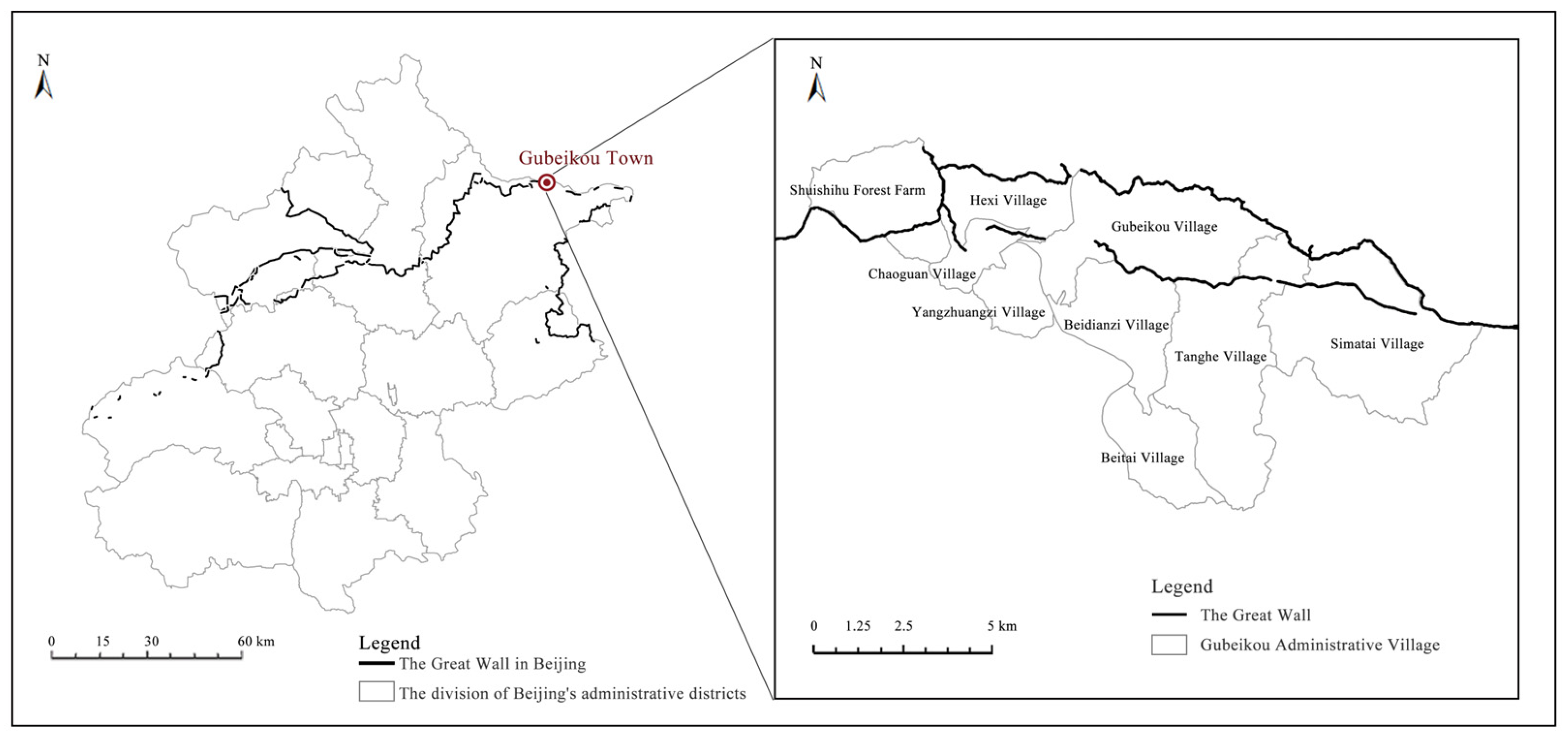
Figure 1. Location and administrative village divisions of Gubeikou Town, Miyun District, Beijing.
Buildings 15 03495 g001
Figure 2. Conducting text analysis with an excerpt from Veritable Records of Emperor Muzong of the Ming Dynasty (≪明实录・穆宗实录≫) as an example.
Buildings 15 03495 g002
Figure 3. Research Path of the Article.
Buildings 15 03495 g003
Figure 4. Dynasties of Historical Events and Time Nodes of Backgrounds of Important Events in the Gubeikou Area.
Buildings 15 03495 g004
Figure 5. Biplot of Correlation Features Between Event Types and Landscape Elements (PC1-PC2) across Major Periods: (a) Military Embryonic Period; (b) Functional Expansion Period; (c) Systemic Maturity Period; (d) Multiethnic Integration Period.
Buildings 15 03495 g005
Figure 6. AHC Plot of Landscape Elements Within the Major Periods: (a) Military Embryonic Period; (b) Functional Expansion Period; (c) Systemic Maturity Period; (d) Multiethnic Integration Period.
Buildings 15 03495 g006
Figure 7. Biplot of Correlation Features Between Event Types and Landscape Elements (PC1-PC2) in the Gubeikou Region Throughout the Entire Period.
Buildings 15 03495 g007
Figure 8. AHC Plot of Landscape Elements in Gubeikou Town Throughout the Entire Time Period.
Buildings 15 03495 g008
Figure 9. Military Landscape Pattern of Gubeikou Before the Ming Dynasty.
Buildings 15 03495 g009
Figure 10. Military Cultural Landscape Pattern of Gubeikou During the Ming and Qing Dynasties.
Buildings 15 03495 g010
Figure 11. Post Road Cultural Landscape Pattern of Gubeikou.
Buildings 15 03495 g011
Figure 12. Productive Cultural Landscape Pattern of Gubeikou.
Buildings 15 03495 g012
Figure 13. Architectural Cultural Landscape Pattern of Gubeikou.
Buildings 15 03495 g013
Figure 14. Results of Textual Analysis of Stele Inscription of Guanwang Temple by Zhu Zeng, Principal Clerk of the Ministry of Justice in the Ming Dynasty (≪明刑部主事祝增关王庙碑记≫).
Buildings 15 03495 g014
Table 1. Relevant Formulas of PCA.
IndicatorFormulaRemarksDefinition
Z-score standardization z i = x i x ¯ σ x i is the original variable value, x ¯ is the variable mean, and σ is the standard deviation.Standardize the original data to eliminate differences in dimensions.
Covariance matrix of standardized data S = 1 n 1 i = 1 n ( z i z ¯ ) ( z i z ¯ ) T n is the sample size, z i is the standardized data, and z ¯ is the mean vector of standardized dataThe covariance matrix of standardized data reflects the correlation between variables
Variance contribution rate C R k = λ k i = 1 p λ i Where λ k is the eigenvalue of the k-th component, and p is the total number of original variablesLarger values mean stronger explanatory power of the principal component for original data.
Table 2. Historical Data System for Text Mining.
TypeNames of Historical BooksCharacteristicsRecorded Content
General History in Biographical StyleRecords of the Grand Historian (≪史记≫), History of the Southern Dynasties (≪南史≫), History of the Northern Dynasties (≪北史≫)Spanning multiple dynasties, integrating content through the biographical style (including Basic Annals (本纪), Biographies (列传), Treatises (志), and Tables (表)), breaking the boundaries between dynastiesCross-dynastic political, economic, and cultural contexts, highlighting the continuity of families and ethnic groups, including the imperial court and all social strata
Biographical Dynastic HistoriesBook of Han (≪汉书≫), Records of the Three Kingdoms (≪三国志≫), History of the Jin Dynasty (≪晋书≫), History of Song of the Southern Dynasties (≪宋书≫), Book of Southern Qi (≪南齐书≫), Book of Liang (≪梁书≫), Book of Chen (≪陈书≫), History of Wei of the Northern Dynasties (≪魏书≫), Book of Northern Qi (≪北齐书≫), History of Northern Zhou Dynasty (≪周书≫), History of the Sui Dynasty (≪隋书≫), Old History of Tang Dynasty (≪旧唐书≫), New History of Tang Dynasty (≪新唐书≫), Old History of the Five Dynasties (≪旧五代史≫), New History of the Five Dynasties (≪新五代史》), History of Song (≪宋史≫), History of the Liao Dynasty (≪辽史≫), History of the Jurchen Jin Dynasty (≪金史≫), History of the Yuan Dynasty (≪元史≫), History of the Ming Dynasty (≪明史≫)Focusing on a single dynasty, concentrating on recording historical events of the dynasty itself in biographical style, and strengthening the integrity of “the history of one dynasty”Political and military affairs of the dynasty; institutional systems; deeds of important figures
Annals-Style Veritable RecordsVeritable Records of the Ming Dynasty (≪明实录≫), Veritable Records of the Qing Dynasty (≪清实录≫)Centered on the emperor, recorded chronologically by “year, month, day”, reflecting the official imperial power narrativeEmperor’s words and deeds, central government decisions; national ceremonies, wars, personnel appointments and removals; avoiding records of ruling crises and details of civil society
Local ChroniclesMiyun Gazetteer (≪密云县志≫)Covering a specific region, focusing on grassroots affairs, highlighting local practical valueLocal geography, administration, economy, culture, historic sites, etc.
Inscriptions on Steles-Detailed records of single events in the regionMainly recording the construction of temples and military facilities, and the commendation of meritorious persons
Table 3. Induction of Gubeikou Event Types and Their Interpretations.
Event TypeInterpretation
Construction of Defense WorksRecords events of resisting foreign enemies and consolidating defense, involving building or repairing forts, passes, and fortresses to construct or maintain defense facilities.
Military DeploymentRecords military deployment events, including garrisoning, training, expeditions, and officer appointments/removals, with two patterns: deploying troops to Gubeikou and dispatching troops from Gubeikou.
Military ConflictsRecords territory contests and resistance against invasions, involving battles, sieges, and surprise attacks, possibly accompanied by regime changes, territorial shifts, population migration, or resource transfers.
Material TransportationRecords events of ensuring military supplies and allocating resources, involving canal/land transportation and transfer stations, acting on grain, armaments, and warehouses to meet material needs.
Cultural ExchangeRecords events of reaching other regimes’ territories, including diplomatic visits, religious spread, and journey observations/anecdotes.
Domestic TransitRecords internal transportation events to reach destinations, possibly with road construction, river dredging, or transfer point setup.
Post Station EstablishmentRecords establishment or abolition of post stations as needed, aimed at document delivery and postal transportation.
Productive ActivitiesRecords events of obtaining materials and sustaining livelihoods, involving farming, animal husbandry, and handicrafts, acting on land, crops, and livestock for material multiplication.
Commercial TransactionsRecords commodity exchange and financial supplementation events, involving transactions, trafficking, and mutual trade to realize regional circulation or government subsidies.
Natural DisastersRecords historical disasters (mainly floods, droughts) causing casualties, crop failures, building collapses, or social unrest.
Water Conservancy ProjectsRecords events of digging wells, building bridges, constructing dikes/canals, aimed at flood control, disaster reduction, and farmland irrigation.
Architectural ConstructionRecords construction, expansion, or renovation of ancestral temples, buildings, and official residences, aimed at strengthening feudal ethics, expressing beliefs, or meeting military/civilian needs.
Table 4. Landscape Elements in the Gubeikou Area—Corresponding Types in Ancient Books and Reality, Specific Names, and Interpretations.
Types of Landscape ElementsSpecific Landscape Names in GubeikouExplanations of Landscape Elements
Yamen ArchitectureCustoms House (Ancient Site), Miyun Houwei Yashu, Yanwu Hall, Canjiang Yamen, Tidu Yashu, Xunjian Yamen, Tongzhi YashuYamen buildings refer to the buildings of ancient official administrative institutions, and also serve as places for officials to live and work.
TempleErlang Temple, Confucius Temple (Ancient Site), Yanglinggong Temple, Yuhuang Temple, Lvzu Temple, Thousand-Layer Tower (Ancient Site), Mosque, Wenshen Temple, Niangniang Temple, Nantianmen (Ancient Site), Guandi Temple, Dragon King Temple, Medicine King Temple, Guanyin PavilionPlaces for offering sacrifices to and worshipping gods, Buddhas, ancient sages, or objects of religious belief.
Post StationGubeikou Courier Station (Qing Dynasty), Gubeikou Pavilion (Liao Dynasty) (Ancient Site)Ancient institutions and auxiliary buildings for couriers delivering official documents, traveling officials, as well as merchants and travelers to lodge and change horses on the way.
Commercial BuildingYixinchang Cloth Store, Juyuahao Variety Store, Gubeikou Sericulture and Weaving BureauBuildings serving as places for production and commercial activities, such as shops, commercial firms, workshops, factories, etc.
Folk HouseMeng Family Compound, Duan Family Compound, Zhu Yonghai’s Folk House, Daokou Compound, Bai Family Compound, Hao Family Compound, Houzhuang Village Primary School, Zhou Shufen’s Folk HouseResidential buildings refer to dwellings for common people.
Ancient WellThree-Eyed WellTime-honored wells are an important source of domestic water for ancient residents.
Ancient BridgeGubeikou Stone BridgeAncient bridges, mostly built to cross natural or man-made obstacles such as rivers, canyons, and depressions, have both transportation functions and architectural artistic value.
Grain WarehouseGubeikou Granary (Ancient Site)Warehouses for storing grain.
WallsThe Great Wall of the Northern Qi Dynasty, Great Wall of the Ming DynastyMan-made Great Wall walls.
FortChaoheguan Fortress, Beikou Fortress (Ancient Site), Simatai Fortress, Gubeikou Fortress, Shangying Fortress, Shalinggou Fort, Zhuanduozi Fort, Hexi Fort, Gubeikou Barbican, Shipogu Fort, Liulin Camp, Five Battalions of the Trained ArmyEnclosed wall facilities mainly for defense and garrison, some of which also serve as places for military and civilian production, living, and administrative activities. They are distributed on flat land or connected to the Great Wall walls.
Fortified PassHuangyugou Pass, Gezidong Pass, Gubeikou Pass, Shipogu Pass, Wuliduo Pass, Longwangyu Pass, Taochun Pass, Zhuanduozi Pass, Shaling Pass, Yajishan Pass, Simatai Pass, Hongmengou Pass, Yinziyu Pass, Tanghekou Pass, Huai’gucheng PassPasses refer to passable defense facilities set at natural mountain passes, some of which are connected to walls and mainly distributed in valleys and river valleys.
Chambered TowerMiyun Towers No. 257–384, No. 1–3 Defence Towers of the Northern Qi Dynasty in Chaoguan VillageDefensive beacon towers built on the Great Wall walls, which can be used for watching, garrisoning, or beacon communication.
Market StreetGubeikou Market StreetStreets with commercial transactions as their core function, gathering various shops and stalls, serving as places for daily folk trade and communication.
Gubeikou RoadGubeikou Road (Pre-Yuan Dynasty), Gubeikou Road (Ming and Qing Dynasty)Ancient post roads verified by historical research.
RiverChao River, Xiaotang RiverNaturally formed surface water channels are an important part of natural landscapes.
MountainWohu Mountain, Panlong Mountain, Fufeng Mountain, Yaji Mountain, Huanghua MountainNaturally formed highland terrain, which can form a reliable defense line when combined with military defense facilities.
Plant (Ancient Tree)Agricultural Landscape, Ancient Trees (Grade I and II)Plants dominated by crops, farmland landscapes, and existing ancient trees are all regarded as such landscape elements.
Industrial CultureAgriculture, Handicraft Industry, Animal Husbandry, Mining Industry, IndustryMainly referring to several industrial types that once appeared in the Gubeikou area, reflecting the development of production methods.
Faith CultureTaoism, Islam, Confucianism, Buddhism, Folk hero beliefCulture related to religion and folk beliefs, including local belief concepts, folk stories, etc.
Table 5. Summary of Major Periods in the Historical and Cultural Development of the Gubeikou Area.
Major PeriodsInvolved Dynasties and YearsPeriod Characteristics
Military Embryonic PeriodZhou to Sui Dynasties (1046 BCE–618 CE)Military and cultural collisions between regimes formed the cultural keynote of this stage, with the Northern Qi Dynasty constructing the earliest military landscapes.
Functional Expansion PeriodTang to Yuan Dynasties (714–1368 CE)The Tang Dynasty established shouzhuo (military garrisons) to balance border defense and production management. The Treaty of Chanyuan strengthened cross-regime exchanges, while incessant military conflicts among the Song, Liao, Jin, and Yuan regimes continued the military cultural thread. This period saw multifaceted development marked by agricultural germination, economic and cultural prosperity, and foreshadowing ethnic integration in border regions.
Systemic Maturity PeriodMing Dynasty (1368–1602 CE)During this period, the military function of Gubeikou continued to strengthen. The Ming Dynasty perfected its defense system, with postal routes and ritual architectures all serving military purposes, forming a highly systematized landscape pattern of “controlling the border through a military network.”
Multiethnic Integration PeriodLate Ming to Qing Dynasty (1602–1911 CE)During this period, Gubeikou witnessed intensified ethnic integration and the rise of border trade. In the late Ming Dynasty, Nurhaci unified northern tribes and established the Later Jin regime, triggering continuous instability along the Ming frontier. In the Qing Dynasty, the opening of the Imperial Road and the establishment of the Tidu Office (Regional Military Command) drove functional transformation, creating a thriving landscape of military, economic, and cultural activities and positioning Gubeikou as a comprehensive borderland hub.
Table 6. Summary Table of Correlation Features Between Event Types and Landscape Elements and Their Driving Factors Across Major Periods in the Gubeikou Region.
Major PeriodsCorrelation Clustering of Event Types and Landscape ElementsCore Driving Factors
Military Embryonic Period
  • “Cultural Exchange” and “Military Conflicts” show a high correlation with “River” and “Gubeikou Road”;
  • “Construction of Defense Works” shows a high correlation with “Fortified Pass”, “Fort”, and “Walls”.
  • Transportation factor as a natural mountain pass;
  • Military defense factor against the backdrop of Central Plains dynasties resisting northern ethnic groups.
Functional Expansion Period
  • “Military Deployment” shows a high correlation with “Yamen Architecture” and “Mountain”;
  • “Domestic Transit”, “Natural Disasters”, “Military Conflicts”, and “Construction of Defense Works” show a high correlation with “Fort” and “Fortified Pass”;
  • “Cultural Exchange”, “Productive Activities”, “Commercial Transactions”, and “Construction” show a high correlation with “Gubeikou Road”, “Ancient Well”, “Faith Culture”, “Temple”, “Residential Houses”, “Commercial Building”, and “Industrial Culture”.
  • Military deployment factor with mountains as barriers;
  • Military defense factor against the backdrop of wars between the Song, Liao, and Jin dynasties and civil wars between the two capitals of the Yuan dynasty;
  • Industrial development factor under the Treaty of Chanyuan.
Systemic Maturity Period
  • “Material Transportation”, “Productive Activities”, “Commercial Transactions”, and “Establishment of Postal Stations” show a high correlation with “Industrial Culture”, “Grain Warehouse”, “Gubeikou Road”, “Post Station”, and “Plant”;
  • “Military Conflicts” and “Construction of Defense Works” show a high correlation with “Chambered Tower”, “Fortified Pass”, “Fort”, and “Walls”;
  • “Military Deployment” shows a high correlation with “Mountain”, “River”, and “Yamen Architecture”;
  • “Natural Disasters”, “Water Conservancy Projects”, and “Construction” show a high correlation with “Ancient Bridge”, “Temple”, and “Faith Culture”.
  • Border material transportation and storage based on postal routes;
  • Military defense factor against the backdrop of strengthening border defense;
  • Political decision-making factor considering landscape pattern for military deployment;
  • Folk custom and construction activity factor under natural disasters.
Multiethnic Integration Period
  • “Military Deployment”, “Domestic Transit”, “Material Transportation”, and “Establishment of postal stations” show a high correlation with “Gubeikou Road”, “Ancient Bridge”, “Post Station”, and “Yamen Architecture”;
  • “Commercial Transactions” shows a high correlation with “Market Street” and “Commercial Building”;
  • “Productive Activities” shows a high correlation with “Grain Warehouse”, “Industrial Culture”, and “Plant”;
  • “Natural Disasters” and “Construction of Defense Works” show a high correlation with “Chambered Tower”, “Fortified Pass”, ”Walls”, ”river”, and “Fort”;
  • “Construction” shows a high correlation with “Faith Culture”, “Temple”, and “Residential Houses”.
  • Military and political factors against the backdrop of the construction of Imperial Road and the establishment of Tidu Office;
  • Commercial development factors against the backdrop of industrial prosperity;
  • Productive activity factors with local development as the main thread;
  • Military defense factors under natural disasters;
  • Local folk customs and construction factors against the backdrop of cultural integration.
Disclaimer/Publisher’s Note: The statements, opinions and data contained in all publications are solely those of the individual author(s) and contributor(s) and not of MDPI and/or the editor(s). MDPI and/or the editor(s) disclaim responsibility for any injury to people or property resulting from any ideas, methods, instructions or products referred to in the content.