Article

Evaluating Landscape Gene Perception in Traditional Villages for Sustainable Development: A Methodological Framework Integrating Game Theory and the Cloud Model

by
Xiaobin Li
1,
Siyi Chen
2,
Lemin Yu
3,
Robert Brown
4 and
Rong Zhu
1,*
1
School of Design, Jiangnan University, Wuxi 214122, China
2
College of Landscape Architecture and Arts, Northwest A&F University, Xianyang 712100, China
3
School of Landscape Architecture, Beijing Forestry University, Beijing 100083, China
4
School of Art, Design and Architecture, University of Plymouth, Drake Circus, Plymouth PL4 8AA, UK
*
Author to whom correspondence should be addressed.
Buildings 2025, 15(19), 3441; https://doi.org/10.3390/buildings15193441
Submission received: 24 August 2025 / Revised: 18 September 2025 / Accepted: 20 September 2025 / Published: 23 September 2025
(This article belongs to the Section Architectural Design, Urban Science, and Real Estate)

Abstract

The acceleration of global urbanization has caused severe damage to, and even the disappearance of, traditional villages, significantly reducing the diversity of cultural landscapes. To effectively preserve and transmit the cultural landscape characteristics of traditional villages, this study adopts the “landscape gene” theory and proposes a traditional village landscape gene perception evaluation method combining game theory-based weight assignment and the cloud model. Using Huangtutang Village in Wuxi, China, as a case study, the study follows the framework and paradigm of “identification-translation-perception evaluation-preservation inheritance” to identify, translate, map, and comprehensively evaluate its landscape genes. Finally, targeted strategies for the preservation and development of Huangtutang Village are proposed based on the evaluation results. The results indicate that residents and tourists generally perceive the landscape genes of Huangtutang Village as “Satisfied,” with perception levels ranking from high to low as follows: environmental pattern, cultural characteristics, architectural character, and spatial layout characteristics. Perceptions of traffic location, street texture, building form, roof form, facade features, folk tales, and historical and cultural context were relatively low, showing lower “expectation values.” The findings provide valuable references for the preservation and development of Huangtutang Village and other traditional villages. The proposed traditional village landscape gene perception evaluation model advances the development of landscape gene theory, effectively supplements existing methods for traditional village preservation and sustainable development, and demonstrates broad applicability.

1. Introduction

Traditional villages, as carriers of local historical and cultural continuity, not only embody the unique memories of human culture but also reflect the residential environment construction wisdom developed by ancestors to adapt to various regional environments across different historical periods [1]. Traditional villages contain rich cultural genes [2], including agrarian civilization, rural landscapes, architectural art, folk customs, and clan traditions [3], which possess significant value for protection and utilization [4]. China, with its long history of agrarian civilization, has ancient villages that represent spontaneously formed settlement patterns through prolonged human-nature interaction, carrying a wealth of historical memory and cultural heritage [5]. To this end, the Chinese government attaches great importance to the protection of traditional villages, establishing the “Historical and Cultural Towns and Villages” system and initiating the “China Traditional Villages” recognition project to provide institutional support for their preservation and development [6]. However, rapid urbanization and industrialization have profoundly impacted traditional villages. Issues such as the loss of traditional culture [7], diminishing regional distinctiveness [8], and constructive destruction [9] have become increasingly prominent in traditional villages. Deeply deconstructing the cultural landscape features of traditional villages and clarifying their composition and value constitute the core issues in traditional village preservation and research today [10].
In recent years, in light of the increasingly severe challenges in preserving traditional villages, scholars widely recognize the necessity of promoting their protection and development [9]. Some scholars have explored the theories and methods of traditional village preservation and development from multidimensional perspectives, including spatial distribution and morphological characteristics [11,12], cultural-tourism integration [13,14], and heritage value assessment [15,16]. Other studies have examined traditional villages from perspectives such as ecological adaptability [17], climate adaptation [18], and ecological wisdom [19], introducing innovative theoretical approaches like cultural ecology [20], heritage corridors [21], eco-museums [22], and landscape genes [23]. Among these, the theory of landscape genes has become a focal point in traditional village landscape research [24,25]. Numerous studies have confirmed that the landscape gene theory provides a powerful and effective framework for the protection and development of traditional villages [26,27,28]. The theory conceptualizes “landscape genes” as the natural landscape attributes and the historical and socio-cultural information inherent in traditional villages, elucidating the interactions between humans and the natural environment, as well as the traditional knowledge and cultural characteristics embodied therein [29]. Scholars have employed methods such as ArcGIS [30,31] and semiotics [32,33] to explore the pathways of identifying, extracting, encoding, and mapping the landscape genes of traditional villages, achieving significant results. In recent years, some researchers have begun to focus on the study of perception and evaluation of traditional village landscape genes [34,35]. However, current research on landscape gene evaluation remains in its early stages and is largely limited to constructing evaluation models using methods such as analytic hierarchy process [36] and importance-performance analysis [37]. Existing research methods largely rely on qualitative reasoning and subjective judgment to determine weight distribution, failing to fully account for the complexity and multidimensionality of traditional village cultural landscapes [38,39], and overlooking uncertainties and ambiguities in the evaluation process [40], thereby reducing the reliability and scientific validity of evaluation results. To address these issues, it is imperative to develop more comprehensive and scientifically robust evaluation methods to provide stronger theoretical and practical support for the perception and evaluation of traditional village landscape genes. Additionally, addressing the shortcomings of existing methods is crucial for advancing the development of traditional village landscape gene theory. Therefore, to overcome the limitations of previous single-method evaluations, this research proposes a novel perception evaluation method for landscape genes that combines game theory-based weight assignment with cloud models, constructing a systematic research framework and paradigm of “identification-translation, perception evaluation, and preservation-inheritance.” Game theory, as a mathematical modeling method describing strategic interactions between rational and non-rational entities, is specifically designed to resolve conflicts among multiple weights [41], effectively integrating subjective and objective weights and reducing potential biases introduced by single weight assignment methods [42]. The cloud model, proposed by Li Deyi [43], is an effective tool for addressing fuzziness and randomness in evaluations, capable of handling uncertainties in the evaluation process with a high degree of objectivity [44]. Over decades of development, the cloud model has been widely applied in fields such as decision analysis [45,46,47], safety and risk assessment [48,49,50]. Combining game theory with cloud models can effectively address conflicts between subjective and objective weights in the evaluation process, overcoming the limitations of traditional evaluation models that neglect uncertainties [51], thereby enabling a more comprehensive and scientific evaluation of traditional village landscape genes.
Huangtutang Village demonstrates unique advantages in its topography, settlement patterns, living customs, and cultural beliefs, highlighting its significant research value and importance for conservation. The village was included in the sixth batch of Chinese Traditional Villages in October 2022 and was designated as a Jiangsu Province Historical and Cultural Village in 2023. However, with the accelerated pace of socio-economic transformation, the village has undergone functional transitions and spatial reorganization, leading to a gradual weakening or even disappearance of its cultural landscape. The interpretation and evaluation of Huangtutang Village’s landscape genes hold not only significant academic value but also provide scientific evidence and strategic guidance for its conservation and development. Therefore, this research takes Huangtutang Village as its research object, systematically identifies its landscape gene characteristics based on the analytical framework of landscape gene theory, constructs a landscape gene perception evaluation system, and employs a combined method of game theory-based weight assignment and cloud models for comprehensive evaluation of the village’s landscape genes. Based on the evaluation results, this research formulates targeted conservation and development strategies aimed at providing scientific and practical references for the conservation and sustainable development of Huangtutang Village and similar traditional villages.

2. Research Area and Methods

2.1. Overview of the Research Area

Huangtutang Village is located on the northwestern edge of Donggang Town, Wuxi City, Jiangsu Province, China (Figure 1), situated in the wetland region where the three counties of Wuxi, Jiangyin, and Changshu. Historical records indicate that the village has a history spanning over 1500 years, originating during the Southern and Northern Dynasties and forming its basic layout by the Republican Era [52]. It is a natural village that retains a variety of architectural styles from the late Qing Dynasty onwards. Huangtutang Village boasts a long history, abundant natural resources, and a rich cultural heritage. The village currently preserves two cultural heritage protection units, ten protected buildings and historic alleys, two intangible cultural heritage projects, and numerous traditional structures, ancient wells, bridges, and trees. Its rich cultural landscape genes hold significant value for protection and research. Therefore, selecting Huangtutang Village as the subject for evaluating traditional village landscape genes is both typical and representative. Its abundant cultural landscape features not only offer a unique perspective for studying the cultural inheritance and preservation of traditional villages but also provide significant demonstration potential and practical reference for the sustainable development of similar villages.

2.2. Research Methods

2.2.1. Landscape Gene Theory and Its Identification

The concept of “landscape gene” originates from “biological gene” [53] and shares similar characteristics of inheritance and variation. In 2003, Chinese scholar Liu Peilin proposed the concept of “traditional village landscape gene” based on an in-depth analysis of the imagery characteristics of Chinese traditional villages [54,55]. He argued that traditional village landscape genes are the fundamental elements and cultural factors that define a village’s unique landscape form and character, serving as the foundational units for landscape inheritance and development [56]. Landscape genes encompass not only the natural landscape attributes of a village but also its rich historical and socio-cultural information [57], characterized by distinct recognizability, perceptibility, and inheritability.
The identification of landscape genes is a fundamental step in landscape gene research. Analyzing the composition, structure, and forms of landscape genes can reveal their intrinsic logic and order. Building upon previous studies, this research adheres to the principles of “internal uniqueness, external uniqueness, local uniqueness, and overall predominance,” [58] employing a feature deconstruction method [59] to classify the landscape characteristics of traditional villages and develop a comprehensive set of landscape gene identification indicators. Subsequently, based on the principle of “merging similar categories,” the identified results were systematically grouped and integrated, ultimately constructing a landscape gene identification indicator system.

2.2.2. Subjective and Objective Weighting Methods

  • The Analytic Hierarchy Process
The analytic hierarchy process is a multi-criteria decision-making method [60] that involves constructing a hierarchical model comprising three levels: goal, criterion, and factor. This method assists decision-makers in reducing biases and minimizing differences in consensus among expert teams [61]. In this study, the analytic hierarchy process was applied to construct a perceptual evaluation framework for the landscape genes of Huangtutang Village. Experts were invited to score each indicator within the evaluation system, and pairwise comparisons were used to assess relative importance, thereby deriving indicator weights that quantify the role of different landscape genes in shaping village perception. The specific steps are outlined as follows:
First, an expert questionnaire was developed based on the evaluation system, and experts are invited to evaluate the relative importance of the criteria on a nine-point scale. These ratings are then used to construct pairwise comparison matrices between hierarchical levels, as shown below.
A = a 11 a 12 a 1 j a 21 a 22             a 2 j a i 1 a i 2 a i j
Here, a i j represents the relative importance of indicator i compared to indicator j.
Next, based on the obtained judgment matrix, calculate the weight vectors and determine the maximum eigenvalue of the matrix, using the formula:
λ m a x = 1 n i = 1 n A ω i ω i
Subsequently, derive the weight results for each indicator and perform a consistency check to avoid discrepancies caused by subjective cognitive biases of evaluators. Calculate the consistency index C . I . using the formula:
C . I . = λ m a x n n 1
R . I . represents the average random consistency index, with its values listed in Table 1. C . R . is the consistency test indicator, calculated using the formula:
C . R . = C . I . R . I .
If C . R . < 0.1, the consistency test is passed; if C . R . > 0.1, the judgment matrix fails the consistency test and must be adjusted until it passes.
Finally, after completing the consistency test, compute the weights of each layer’s indicators with respect to the overall evaluation objective.
2.
Entropy Method
The entropy method is a classical objective weighting approach. It is simple to operate and determines the weight distribution based on the amount of information contained in each evaluation criterion. This method effectively prevents slight variations among indicators from causing significant deviations in weights, ensuring that the resulting weight values are highly reliable [62]. In this study, the entropy method was employed to determine the objective weights of landscape gene indicators in Huangtutang Village. Expert scores for each indicator were standardized and used for calculation. The method allocates weights by assessing the information contained in inter-sample variability: the greater the variation, the higher the contribution of that indicator to the overall evaluation, and consequently, the greater its assigned weight. This approach ensures a more rigorous and rational distribution of weights. The specific steps are as follows:
(1) Assume there are n indicators and m evaluation objects. An evaluation matrix X = X i j m × n is constructed to represent the set of evaluation criteria, where X i j denotes the evaluation value of the i-th object for the j-th indicator. After standardizing the data for each indicator, the normalized values are Y 1 , Y 2 , , Y n , given as follows:
Y i j = X i j m i n X i m a x X i m i n X i ,   positive   indicators
Y i j = m a x X i X i j m a x X i m i n X i ,   negative   indicators i = 1 , 2 , , m ; j = 1 , 2 , , n
(2) Calculate the proportion of each indicator for each evaluation object, using the formula:
P i j = Y i j j = 1 n Y i j
(3) Calculate the information entropy value for each indicator using the formula:
e j = k i = 1 n P i j ln P i j
where K = 1 ln n .
(4) On this basis, the redundancy degree was calculated using the following formula:
d j = 1 e j
(5) Compute the weights of each indicator using the formula:
ω j = d j j = 1 n d j

2.2.3. Game Theory-Based Combined Weighting

The game theory-based combined weighting method is a technique for resolving conflicts between different weighting methods, effectively balancing subjective and objective weights to achieve equilibrium [63]. This method embodies the concept of methods competing while maintaining consistency [64], providing a more scientific, accurate, and comprehensive solution for determining weight values [65]. In this study, the game theory-based combined weighting method was applied to integrate the results of the analytic hierarchy process and the entropy method, thereby mitigating potential biases from using a single approach. The principle is to treat the subjective weights derived from analytic hierarchy process (reflecting expert judgment) and the objective weights from the entropy method (reflecting variability in survey data) as two “participants” that iteratively adjust through a game process until reaching equilibrium. For example, in the evaluation framework of Huangtutang Village, the indicator “topography and landform” was assigned a higher weight in analytic hierarchy process (as experts generally regarded it as fundamental to village spatial structure), but a lower weight in the entropy method (due to limited variability in survey responses). The game theory method computes a coordination coefficient to yield a balanced weight, capturing both expert insights and data-driven features. The resulting weights reduce excessive subjectivity and avoid purely mechanical bias, producing more robust and scientifically grounded evaluation outcomes. The specific calculation steps are as follows:
(1) Establish a basic weight vector set:
ω q = ω 1 , ω 2 , ,   ω n q = 1 ,   2 , , p
where n represents the number of evaluation indicators, and p denotes the number of weighting methods.
As this research primarily integrates analytic hierarchy process and the entropy method to calculate comprehensive weights, let p = 2 , and assume α = α 1 , α 2 as the linear combination coefficients. The linear combination of the two weight vectors is expressed as follows:
ω = α 1 ω 1 T + α 2 ω 2 T
Here, ω 1 represents the subjective weight vector derived from analytic hierarchy process, and ω 2 represents the objective weight vector set derived from the entropy method. α 1 and α 2 denote the coefficients corresponding to the analytic hierarchy process and the entropy method, respectively.
(2) Following combinatorial game theory, the two linear combination coefficients were optimized to minimize deviation, thereby yielding the optimal weight vector ω . The objective function is expressed as:
m i n p = 1 n α p ω p T ω p 2
(3) The above equation can be equivalently transformed into a system of linear equations by applying the first-order derivatives for optimization, based on matrix differential properties.
ω 1 ω 1 T ω 1 ω 2 T ω 2 ω 1 T ω 2 ω 2 T α 1 α 2 = ω 1 ω 1 T ω 2 ω 2 T
(4) The optimized combination coefficients, α 1 and α 2 , were calculated and normalized. The normalization expression is given as:
α 1 = α 1 α 1 + α 2 α 2 = α 2 α 1 + α 2
(5) Compute the combined weights, denoted as:
ω = α 1 ω 1 T + α 2 ω 2 T

2.2.4. Cloud Model

Academician Li Deyi [43,66] of the Chinese Academy of Engineering introduced the cloud model in 1995. Its core lies in defining three numerical characteristics: expectation ( E x ), entropy ( E n ), and hyper-entropy ( H e ). By constructing a cloud generator, it facilitates the transformation between qualitative linguistic concepts and quantitative numerical values, effectively addressing fuzziness and uncertainty in evaluation processes. In this study, the cloud model was employed to transform the fuzzy evaluations of residents and tourists regarding the landscape genes of Huangtutang Village into quantifiable parameters. Conceptually, the model functions as a “translation tool,” converting linguistic assessments such as “very dissatisfied,” “dissatisfied,” “neutral,” “satisfied,” and “very satisfied” into measurable values. These qualitative expressions, inherently subjective and imprecise, are unsuitable for direct quantitative analysis. To address this, the cloud model maps linguistic categories to numerical intervals—for instance, “very satisfied” corresponds to values near 90–100, while “very dissatisfied” falls within 0–25. Each indicator then generates three key parameters: the expectation ( E x ), representing the average consensus of evaluations; the entropy ( E n ), reflecting the degree of divergence among responses; and the hyper-entropy ( H e ), indicating the stability of such divergence. Through this process, vague linguistic judgments are systematically converted into precise numerical features. To ensure scientific rigor, calibration and validation were further conducted. Calibration established rational correspondences between linguistic grades and numerical intervals based on the current conditions of Huangtutang Village, a literature review, and expert consultation, thereby ensuring input consistency. Validation was performed by comparing the expectations produced by the model with the mean scores of respondents, confirming the alignment of indicator rankings and overall trends. The steps are as follows:
(1) Defining the Standard Cloud for Evaluation
The evaluation domain U is divided into several sub-intervals according to the evaluation standard levels. For each sub-interval, the three numerical characteristics of the corresponding standard cloud are calculated as follows:
E x = T m i n + T m a x 2 E n = T m a x T m i n 6 H e = k
In the formula, E x denotes the mathematical expectation of the domain space distribution, reflecting the fundamental certainty of qualitative concepts and serving as the expected value of the cloud model for the indicator. E n represents the entropy of the cloud model, capturing the degree of uncertainty inherent in qualitative concepts. T m a x and T m i n are the maximum and minimum values of the evaluation set, respectively, while H e represents the dispersion of the entropy. The constant k, representing the fuzzy threshold for evaluation, is fixed at 0.01 following Wu et al.’s study [67].
(2) Calculating Cloud Parameters for Evaluation Indicators
In the expert scoring method, each indicator is evaluated by m experts across n indicators. Let X i j denote the score assigned by the i-th expert to the j-th indicator i = 1, 2, …, m and j = 1, 2, …, n. The three numerical characteristics of the cloud model— E x , E n , and H e —are then derived using the inverse cloud generator. Accordingly, the evaluation cloud for the j-th indicator is expressed as C j E x j ,   E n j ,   H e j , where j = 1, 2, …, n. The corresponding formula is:
E x j = 1 m i = 1 n X i j E n j = π 2 × 1 m H e j = S 2 E n j 2 i = 1 m X i j E x j
In the formula, S j 2 = 1 m 1 i = 1 m X i j E x j 2 represents the variance of expert scores for the j-th evaluation indicator.
(3) Calculating Comprehensive Cloud Parameters
After deriving the numerical characteristics of the secondary indicators, the comprehensive indicator weights are integrated with the corresponding cloud characteristic parameters to generate the overall evaluation cloud for the object. The calculation is given by:
E x = j = 1 n E x j × E n j × ω j j = 1 n E n j × ω j E n = j = 1 n E n j × ω j H e = j = 1 n H e j × E n j × ω j j = 1 n E n j × ω j
(4) Generating a Comprehensive Evaluation Cloud Diagram
Utilize a forward cloud generator to create a comprehensive evaluation cloud diagram within the domain space.

2.3. Research Framework

From May to June 2025, an in-depth investigation of the current status of Huangtutang Village in Wuxi was conducted through participatory observation and group interviews, complemented by on-site surveys, aerial mapping, and video documentation. Additionally, historical records such as Huangtutang Village Chronicle, Suggestions for the Protection and Restoration of Huangtutang Ancient Village Architectural Heritage, Huangtutang Village Ecological Planning, and Stories of Huangtutang were analyzed alongside news reports to identify and translate the landscape genes of Huangtutang Village across four dimensions: environmental patterns, spatial layout, architectural style, and cultural characteristics, culminating in the creation of a genetic map. Subsequently, a perception-based evaluation system was developed using a combined approach of game theory-based weight assignment and the cloud model, enabling a comprehensive assessment of Huangtutang Village’s landscape genes and an exploration of the perception of these genes by residents and visitors. Finally, targeted conservation and development strategies were proposed based on the evaluation results.

3. Construction of Landscape Gene Identification and Evaluation System for Huangtutang Village

3.1. Landscape Gene Identification and Translation

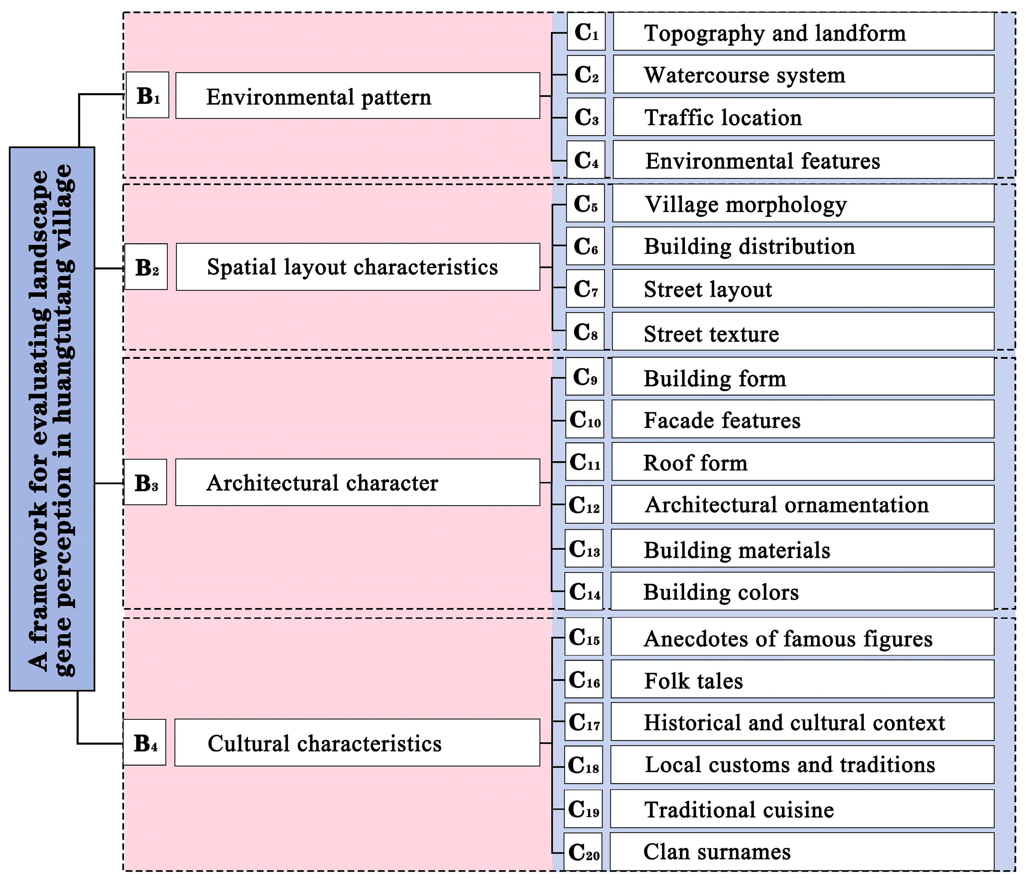
This research is based on the theory of landscape genes and its identification principles. According to the material forms and expressions of cultural landscapes, the landscape genes of Huangtutang Village are categorized into two main types: explicit genes (physical spatial environment) and implicit genes (historical and cultural elements) [68]. Explicit genes encompass three dimensions: environmental pattern, spatial layout characteristics, and architectural character. Environmental patterns include topography and landform, watercourse system, traffic location, and environmental features. Spatial layout characteristics include village morphology, building distribution, street layout, and street texture. Architectural character covers building form, facade features, roof form, architectural ornamentation, building materials, and building colors. Implicit genes focus on cultural characteristics, specifically including anecdotes of famous figures, folk tales, historical and cultural context, local customs and traditions, traditional cuisine, and clan surnames (Figure 2).

3.1.1. Environmental Pattern: Interwoven Water Networks and the Integration of Commerce and Development

Huangtutang Village is located at the junction of the former Wuxi, Jiangyin, and Changshu counties, characterized by low-lying terrain interwoven with a dense network of water systems, including ponds, weirs, rivers, pools, and bays, with Dongqing River encircling the village, providing abundant natural water resources. Leveraging its unique geographical environment and water-land transportation advantages, Huangtutang Village gradually developed into an important commercial hub in Wuxi during the Ming and Qing dynasties. Villagers made full use of the abundant water resources by constructing shops and residences along the riverbanks, thereby driving the prosperity and development of the trade economy. The rise and evolution of the village were closely tied to its unique water network geography, which not only created favorable conditions for agricultural production but also facilitated the rapid growth of the trade town. Huangtutang Village has preserved numerous historical and cultural relics, such as the ancient Wangchuan Bridge and Ming Dynasty wells, highlighting the village’s long history. Additionally, ancient trees such as osmanthus and boxwood, having withstood centuries of wind and rain, stand as witnesses to the village’s rise and decline. These historical relics and natural landscapes collectively form the unique ecological and cultural character of Huangtutang Village, showcasing its profound historical depth and rich rural heritage.

3.1.2. Spatial Layout Characteristics: Grid-like Streets and Clustered Layouts Interwoven with Water Systems

The spatial layout of Huangtutang Village exhibits a cohesive relationship between streets and waterfronts, forming a compact circular plan characteristic of typical water-town villages. The architectural forms within the village are diverse, with cluster layouts influenced by geographical conditions and street patterns, exhibiting characteristics of clustered, street-aligned, scattered, and row-arranged. Serving as the commercial hub, Huangtutang Old Street functions as a trade route and the village’s central axis, extending into a grid-like network of over twenty secondary streets that form the spatial framework. The nodes within the street network are diverse, predominantly featuring T-shaped, cross (“十”)-shaped, and L-shaped configurations. Alleyways are primarily paved with yellow stone slabs, blue bricks, and cement, forming a distinct texture that highlights the rich architectural character of the region.

3.1.3. Architectural Character: Republican-Era Esthetics Featuring Blue Bricks, Gray Tiles, and Wooden and Stone Components

The architectural character of Huangtutang Village is reflected in six aspects: building form, facade features, roof form, architectural ornamentation, building materials, and building colors. In terms of form, the buildings exhibit diverse spatial enclosures, including square (“口”)-shaped, U-shaped, L-shaped, and Linear (“一”)-shaped, reflecting flexibility and versatility in spatial use. Roof structures are predominantly hard-gable and suspended-gable designs, commonly featuring gabled end walls, with the common use of “human (‘人’)-shaped” gable walls. Some buildings also incorporate “T-shaped” parapet walls atop the gables. Brick walls and wooden columns share the structural load, with exposed wooden columns enhancing the buildings’ distinct regional character. The use of materials in Huangtutang Village includes stone, blue bricks, wood, and glazed tiles, employed for foundations, courtyards, window frames, and roofs, maintaining the authenticity of the materials and structures while preserving the vernacular architecture of Wuxi’s Republican-era rural residences. Local decorations extensively feature stone, brick, and wood carvings, with motifs of flora, fauna, human figures, and cloud patterns, reflecting the aspirations of ancient artisans for a harmonious life. The overall color palette of the architecture—dominated by black, white, and gray—is minimalist yet layered, embodying the region’s distinctive identity and historical character.

3.1.4. Cultural Characteristics: Dual Narratives of Historical Accounts and Local Traditions

Huangtutang Village boasts a long history, with its cultural characteristics prominently reflected in anecdotes of famous figures, folk tales, historical and cultural context, local customs and traditions, traditional cuisine, and Clan surnames. The village has produced numerous historical figures, including Wu Huchen, a martial scholar during the Qing Dynasty, Yao Tongbin, a recipient of the “Two Bombs and One Satellite” medal, and Yan Dingxian, a pioneer of Chinese animated films. Wu Huchen was appointed as an imperial guard by the emperor during the Shunzhi reign of the Qing Dynasty for his exceptional martial arts examination results, while Yao Tongbin laid the foundation for China’s aerospace materials field, leaving an indelible mark on science and history. Additionally, the village is rich in folk tales, such as the legend of “Tuo Wa Zhou” Bo Yuangong, the story of the “Fire God,” and tales surrounding Huangtutang watermelons, which imbue the village with a sense of legend. The historical and cultural context of Huangtutang Village also integrates revolutionary heritage with waterborne trade culture, shaping its distinctive regional identity. The Huangtutang Battle Memorial, established in 1991, and the Yao Tongbin Former Residence, now a scientific education base in Wuxi, are key historical relics, underscoring the village’s profound historical legacy. Folk activities in the village are diverse, encompassing ceremonial festivals and traditional customs. Key examples include the March Temple Fair and Lunar New Year dragon dances, alongside teahouse storytelling and ancient town martial arts, vividly demonstrating the village’s cultural vitality and heritage. In terms of traditional cuisine, the village is renowned for its watermelons grown in “eel blood soil” and its traditional “Huang Pancakes,” both of which are local culinary treasures and integral components of the region’s culture. Furthermore, Huangtutang Village boasts a deep-rooted clan culture, with 49 surnames coexisting harmoniously since the Jiang clan settled during the Yuan Dynasty, forming a unique social structure.

3.2. Construction of the Landscape Gene Perception Evaluation System

Based on the identification and translation of Huangtutang Village’s landscape genes, this research established a criteria layer for evaluating landscape gene perception from four dimensions: environmental pattern, spatial layout characteristics, architectural character, and cultural characteristics. These criteria layers were further detailed into 20 recognition elements (Figure 3).

4. Landscape Gene Perception Evaluation of Huangtutang Village

4.1. Calculation of Combined Weights

To scientifically determine indicator weights, the research distributed evaluation system questionnaires to 30 experts engaged in traditional village and heritage conservation, including local village leaders. Based on their expertise and practical experience, these experts rated the importance of the landscape gene perception evaluation indicators for Huangtutang Village. Subsequently, the research applied the analytic hierarchy process, entropy weight method, and game theory-based combination weighting to comprehensively analyze the questionnaire data and calculate the weights, ultimately deriving the composite weight for each indicator (Appendix A).

4.2. Comprehensive Cloud Model Evaluation

4.2.1. Establishment of Evaluation Criteria and Standard Cloud Grades

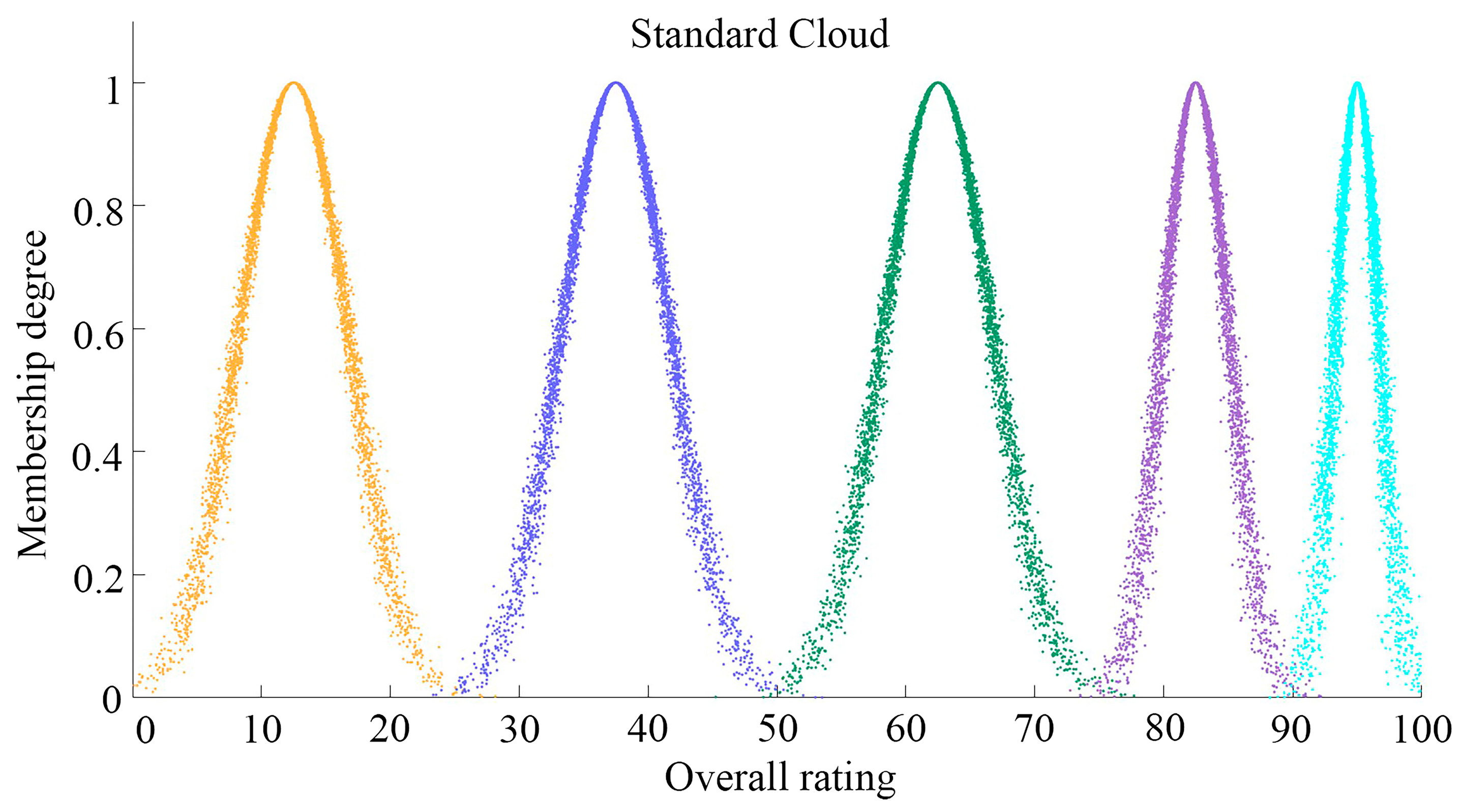
Considering the specific context of Huangtutang Village and expert opinions, this research adopted linguistic terms—” very dissatisfied,” “dissatisfied,” “neutral,” “satisfied,” and “very satisfied”—to describe the levels of landscape gene perception. The corresponding score range was set between [0, 100], where higher scores indicate better perception. Specifically, [0.0, 25.0] represents “very dissatisfied,” (25.0, 50.0] indicates “dissatisfied,” (50.0, 75.0] corresponds to “neutral,” (75.0, 90.0] reflects “satisfied,” and (90.0, 100] signifies “very satisfied.” Based on these scoring intervals, a rational set of evaluation terms was established. Using the evaluation terms, the parameters of the cloud model were derived through a forward cloud generator, thereby generating the evaluation standard cloud model. The corresponding cloud model parameters are presented in Table 2.
Finally, standard cloud charts corresponding to each landscape gene perception level were generated based on the characteristic parameters of the cloud model (Figure 4). To enhance computational precision and mitigate fuzzy errors caused by randomness, the research set the number of cloud droplets at N = 5000, in accordance with the law of large numbers, ensuring the scientific validity and accuracy of the evaluation results.

4.2.2. Calculation of Individual Indicator Clouds and Comprehensive Cloud

This research conducted field investigations in Huangtutang Village from 15 June to 20 June 2025 and distributed a landscape gene perception evaluation questionnaire to explore residents’ and tourists’ perceptions of the village’s landscape genes. The questionnaire was conducted through on-site scoring, with a maximum score of 100, where higher scores indicated stronger perceptions of the evaluated indicators. A total of 230 questionnaires were distributed, with 216 valid responses collected, including 114 from residents and 102 from tourists. The sample data demonstrated high representativeness and reliability, providing a comprehensive reflection of perceptions of Huangtutang Village’s landscape genes. Based on the questionnaire scores, an evaluation matrix was constructed, and the numerical features of the cloud models for the target layer, criterion layer, and factor layers were calculated using a backward cloud generator (Table A2). Subsequently, a forward cloud generator was employed to produce normal cloud maps, providing a scientific basis for subsequent research.

4.3. Results Analysis

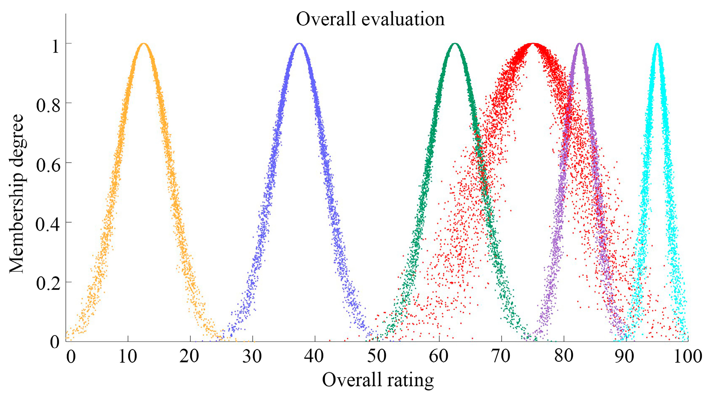
The overall evaluation characteristics can be quantitatively represented using the cloud’s numerical characteristics ( E x , E n , H e ). Among them, the expected value E x represents the quantified central point of a qualitative concept, corresponding to the centroid of cloud droplets within the domain. A higher E x value indicates a higher overall evaluation of landscape gene perception. Entropy E n comprehensively measures the fuzziness and probability of qualitative concepts, reflecting the ambiguity and uncertainty of cloud droplet distribution. A larger E n value suggests a greater span of cloud droplet distribution on the cloud map, indicating higher instability in the overall evaluation. Super-entropy H e , as a measure of the uncertainty of entropy, reflects the degree of cohesion among cloud droplets. An increase in the H e value indicates reduced cohesion of cloud droplets and greater uncertainty in evaluators’ perception of landscape gene evaluation, signifying lower agreement levels. The analysis of the visualized cloud map in Figure 5 reveals that the distribution area of the cloud droplets is well-defined, with an expected value of 75.043, falling within the 75–90 range. This indicates that the overall perception evaluation of Huangtutang Village’s landscape genes is between “Neutral” and “Satisfied,” leaning toward “Satisfied”.
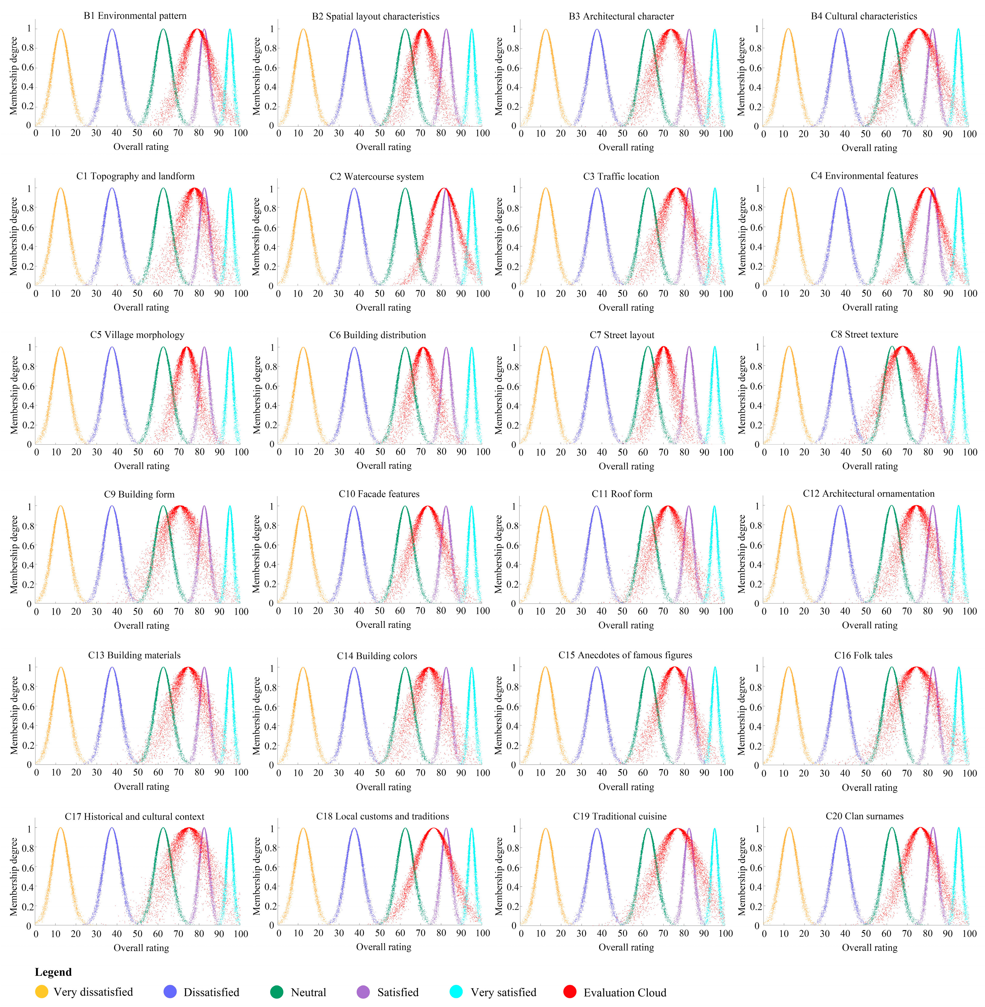
Verification confirms that the numerical characteristic values of all indicators satisfy the condition H e < E n 3 , indicating the validity of the evaluation results. Further analysis reveals that the perception levels of residents and tourists for Huangtutang Village’s landscape genes rank as follows: environmental pattern are perceived the highest, followed by cultural characteristics, with spatial layout characteristics and architectural character being relatively lower (Figure 6).

4.3.1. Perception Evaluation Results of “Environmental Pattern”

The perception of “environmental pattern” within the landscape genes of Huangtutang Village was rated the highest by residents and visitors, with an expectation value of 79.025, surpassing the overall perception score and indicating a strong level of satisfaction. The cloud map for “environmental pattern” demonstrated a concentrated distribution of cloud droplets with a small span and a low hyper-entropy value of 1.31, indicating good stability in the evaluation results and a high level of satisfaction. Analysis of the continuity and concentration of cloud droplets reveals that residents and visitors provided consistent ratings for the “topography and landform,” “watercourse system,” and “environmental features” indicators, with satisfaction scores of 77.653, 81.361, and 79.509, respectively. The cloud maps of these indicators exhibited substantial overlap with the “Satisfied” cloud in the standard cloud map and demonstrated small hyper-entropy values, all aligning with the “Satisfied” level. Overall, the “topography and landform,” “watercourse system,” and “environmental features” are core advantageous resources in the landscape elements of Huangtutang Village, holding significant positions in landscape gene perception. Huangtutang Village owes its prosperity to the river system, as the water networks and geographic environment not only shape the natural ecological foundation of the village but also serve as the primary sources of recognition and emotional connection for residents and visitors. However, the lack of effective environmental protection in recent years has resulted in challenges for the river water system, including direct sewage discharge, garbage accumulation, and water quality degradation. Additionally, modernization has disrupted the traditional environmental patterns, further impacting the village’s landscape. Furthermore, the cloud droplet distribution for the “traffic location” indicator was relatively scattered, with an expectation value lower than the other three indicators, highlighting the negative impact of inadequate transportation facilities on the perception of landscape genes in the village. Although the village is geographically close to a provincial road, the lack of efficient public transportation and comprehensive traffic guidance hinders the convenience of travel for residents and visitors.

4.3.2. Perception Evaluation Results of “Spatial Layout Characteristics”

Residents and visitors have a relatively low perception of the “Spatial layout characteristics” landscape genes of Huangtutang Village. Analysis of the cloud model results indicates that the cloud droplets in the “Spatial layout characteristics” map are poorly concentrated and widely distributed, with an expected value of 70.99, falling within the 50–75 range, suggesting a perception rated as “average,” with significant group perception differences. In terms of cloud droplet cohesion, the dispersion levels of the four indicators range from least to most dispersed as follows: “village morphology,” “street layout,” “building distribution,” and “street texture.” In the distribution range analysis, the cloud droplets of “village morphology” are the most concentrated, with a satisfaction score of 73.912 and a hyper-entropy value of 1.23, whereas “street texture” shows the most dispersion, with a satisfaction score of 67.676 and a hyper-entropy value of 1.817. Village space, as an important carrier of collective memory for villagers, embodies a unique sense of place. However, the rapid advancement of urbanization and inappropriate road planning in recent years have significantly impacted the spatial layout of traditional villages. Traditional village morphology is threatened by fragmentation and encroachment, with the original street patterns and textures disrupted by modern elements, gradually eroding the overall spatial integrity. For instance, newly constructed buildings often lack consideration for spatial coherence with the village, resulting in oversized structures and inconsistent styles, undermining the cultural imagery and spatial continuity of traditional architectural layouts. Modern road construction has disrupted the original street network logic, fragmenting or severing certain street spaces, which significantly reduces spatial coherence and accessibility within the village. The original stone slab and cobblestone paving of streets has gradually been replaced by concrete, greatly diminishing the historical charm. Additionally, issues such as littering and damaged pavement in the streets severely affect visual esthetics and further diminish the overall perception of village texture, necessitating effective protective and restorative measures to improve the situation.

4.3.3. Perception Evaluation Results of “Architectural Character”

The cloud model results indicate that residents and visitors rate the “architectural character” of Huangtutang Village relatively low in terms of perception. The cloud droplets in the “architectural character” cloud model are widely dispersed with a broad horizontal range, and the spans of the droplet layers for individual indicators are similarly large. As the hyper-entropy value increases, the cloud model exhibits more pronounced blurring effects, and the randomness of the droplets becomes more evident. This suggests significant discrepancies in residents’ and visitors’ perceptions of the “architectural character” landscape gene of Huangtutang Village, with notable differences in cognition. Additionally, the expected perception values are lower than the overall perception value, indicating substantial room for improvement in the village’s “architectural character.” Although Huangtutang Village retains many architectural relics, some have suffered extensive collapse. The exposed beams and columns of buildings have experienced severe decay due to prolonged weathering and exposure. Furthermore, a lack of maintenance has led to varying degrees of damage and peeling on building walls and decorative details, particularly severe on eave and window frame carvings, significantly affecting the overall perception of the façades. In recent years, the introduction of modern materials during building repairs and reconstruction has disrupted the consistency of building materials, diminishing the visual impact and cultural significance of traditional materials. Moreover, the simplification and alteration of traditional roof forms have resulted in the loss of the original layering and historical charm of some buildings. New constructions have failed to sufficiently align with the traditional architectural forms, with repainting and modifications introducing colors that deviate significantly from traditional palettes, leading to visual discordance and further undermining the overall coherence of the village’s architectural character.

4.3.4. Perception Evaluation Results of “Cultural Characteristics”

The survey results indicate that the overall perception of the “cultural characteristics” of Huangtutang Village is relatively positive. The “cultural characteristics” cloud map exhibits relatively concentrated cloud droplets, but the wide horizontal span indicates some degree of individual variation in group perception. Specifically, evaluations by residents and visitors show considerable variability for indicators such as “anecdotes of famous figures,” “folk tales,” “historical and cultural context,” “local customs and traditions,” and “clan surnames.” The historical and cultural context, local customs and traditions, folk tales, and associated anecdotes of famous figures of Huangtutang Village collectively form its cultural symbols, garnering significant attention from visitors. However, due to the aging of participating groups and inadequacies in the cultural inheritance system, certain traditional activities are in decline, with a noticeable erosion of their ritual depth and cultural essence. Additionally, traditional culture has not been systematically documented or disseminated, lacking comprehensive historical representation and modern narratives, leading to a significant reduction in its influence and appeal. Dominated by prominent surnames such as Jiang and Yao, the clan ancestral halls in Huangtutang Village carry rich historical memories and emotional connections. However, with the fragmentation of family structures and the migration of younger generations, clan culture is gradually weakening, posing challenges to the village’s cultural identity. For the “traditional cuisine” indicator, the satisfaction score reached 76.944 with a relatively low hyper-entropy value and concentrated evaluation distribution, indicating general satisfaction or higher among residents and visitors. This highlights the significant role of culinary culture within the “cultural characteristics” of Huangtutang Village. Local delicacies such as “Huang Pancakes” and watermelons exemplify the integration of village agriculture and handicrafts, offering residents and visitors a unique cultural experience and enhancing Huangtutang Village’s cultural appeal.

5. Discussion

5.1. Protection and Development Strategies for Huangtutang Village Based on Perception Evaluation

The research revealed that the landscape genes of Huangtutang Village are diverse, characterized by distinctive Jiangnan features and unique local charm, making them a critical component of traditional village preservation and revitalization. Survey results indicate that residents and visitors generally rated their perception of the landscape genes of Huangtutang Village as “Satisfied.” However, cloud model parameters for evaluation metrics such as traffic location, topography and landform, street texture, building form, roof form, facade features, folk tales, and historical and cultural context reveal low expectation values. These areas require targeted measures for improvement and optimization.

5.1.1. Restoration of Damaged Ecological Environments

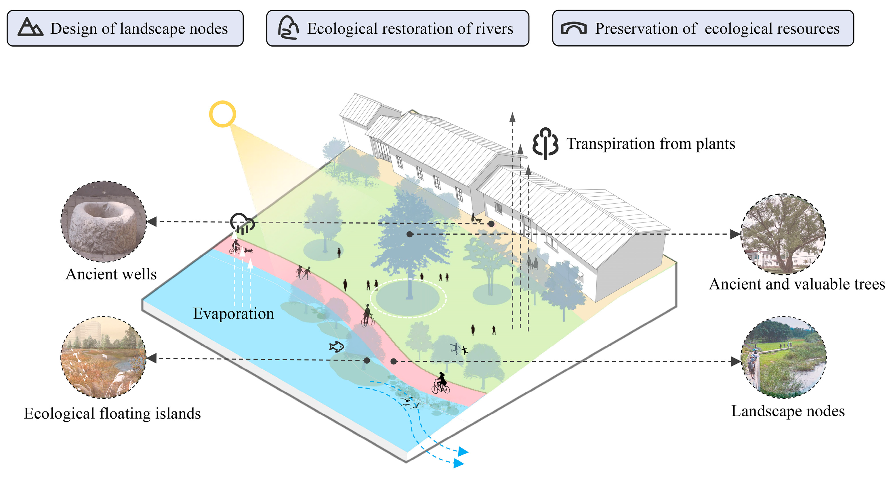
The environmental landscape pattern of traditional villages is a crucial reflection of their cultural, historical, and ecological characteristics [69], and it forms the core of their conservation [70]. Numerous studies have shown that the environmental landscapes of traditional villages play a significant role in enhancing the spatial awareness of residents and visitors [71,72,73]. Residents and visitors reported low perception scores for the traffic location and geomorphology of Huangtutang Village, indicating deficiencies in the improvement of the traffic signage system and in the preservation of natural landform features. Therefore, in shaping the “environmental pattern” gene of Huangtutang Village, priority should be given to preserving its original natural landscapes while limiting the impact of modernization. Specifically, vegetation replanting, land restoration, and optimized design of landscape nodes can enhance the village’s visual continuity and natural ecological perception. To address the pollution challenges in the river systems, systematic water ecological restoration projects should be implemented, including wastewater treatment, garbage removal, and water quality monitoring. Additionally, green belts and recreational paths along the riverbanks should be established to enhance the ecological functionality and accessibility of the water landscape, restoring the village’s sense of place. Furthermore, comprehensive registration, documentation, and designation of protection measures for cultural and ecological resources like ancient trees, wells, ponds, and bridges should be undertaken, with defined protection levels and zones to ensure their integrity and long-term preservation (Figure 7).

5.1.2. Repairing Fragmented Historical Textures

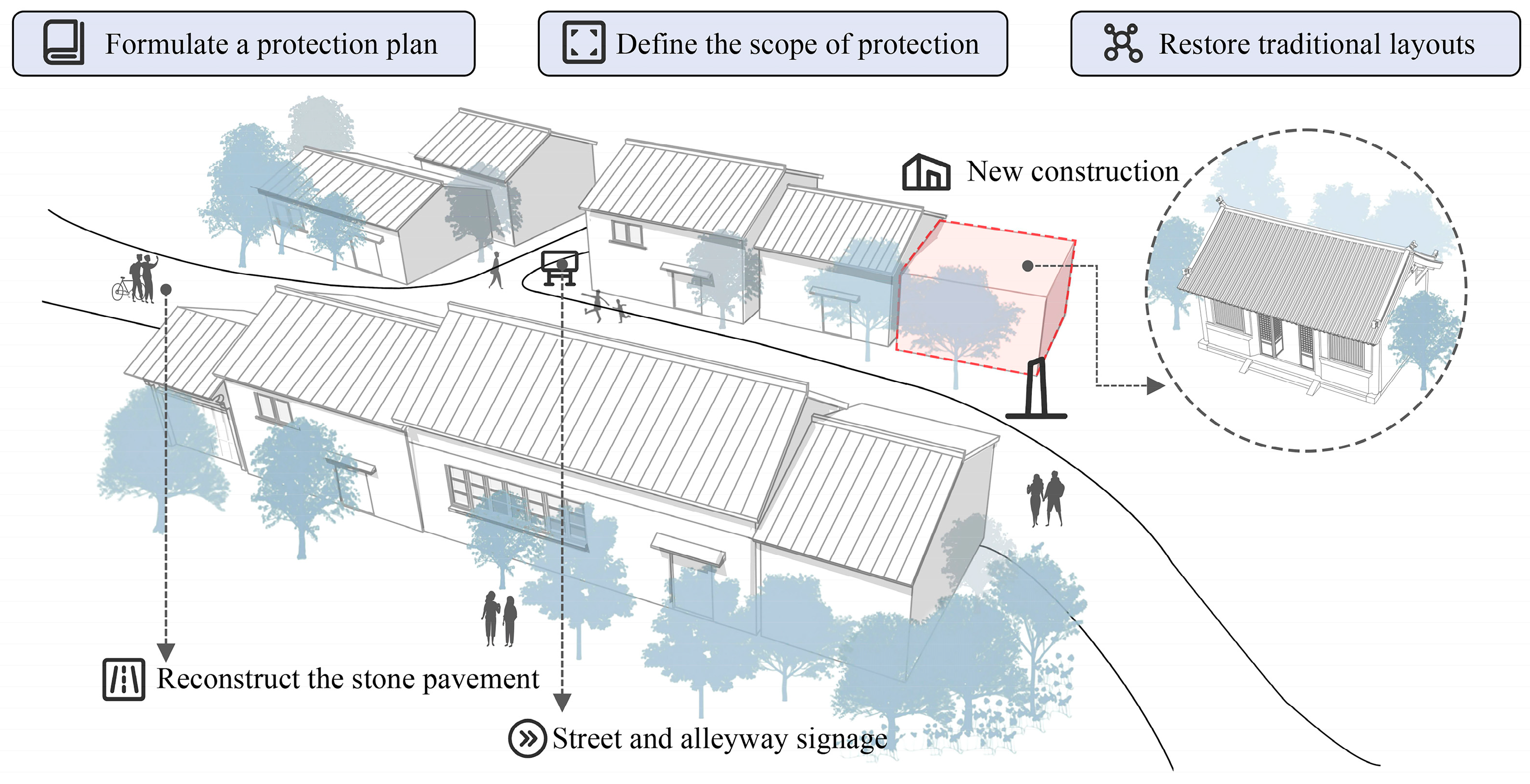
The texture and morphology of village streets and alleys are not only critical components of the village landscape but also external representations of its internal social order and cultural characteristics [74,75]. However, the spatial development of Huangtutang Village’s streets and alleys faces challenges similar to those identified in prior studies, including over-commercialization, spatial homogenization, and arbitrary alterations [76]. Residents and visitors assigned low perception scores to the street texture of Huangtutang Village, reflecting the disruption of its traditional spatial structure, where the original sense of order and historical character has become difficult to discern in everyday experience. Therefore, the preservation and revitalization of Huangtutang Village urgently require the formulation of a scientifically sound protection plan for traditional villages, clearly delineating conservation boundaries and strictly prohibiting destructive development activities. For modern buildings that disrupt the traditional layout of the village, targeted rectification measures should be implemented, while newly constructed structures should be encouraged to align harmoniously with the village’s overall spatial character. Based on the historical scale and unique configuration of Huangtutang Village, scientific methods should be employed to restore the texture of its streets and alleys, ensuring the continuation of the village’s historical scale and distinctive spatial atmosphere. Restoring the layout order and traditional patterns of streets, buildings, and courtyards will further safeguard the village’s integrity and historical significance [77]. The original stone slab and pebble paving of the streets and alleys should be restored, while minimizing the use of modern cement surfaces, to preserve the authenticity and integrity of the village’s original appearance to the greatest extent possible. Additionally, internal and external connection roads should be rationally planned, traffic guidance functions enhanced, and damaged or interrupted alleyways repaired to optimize the internal road network of the village. Introducing traditional street and alleyway signage will not only enhance visitors’ spatial perception experiences but also improve the convenience and functionality of village accessibility (Figure 8).

5.1.3. Preservation and Inheritance of Architectural Heritage

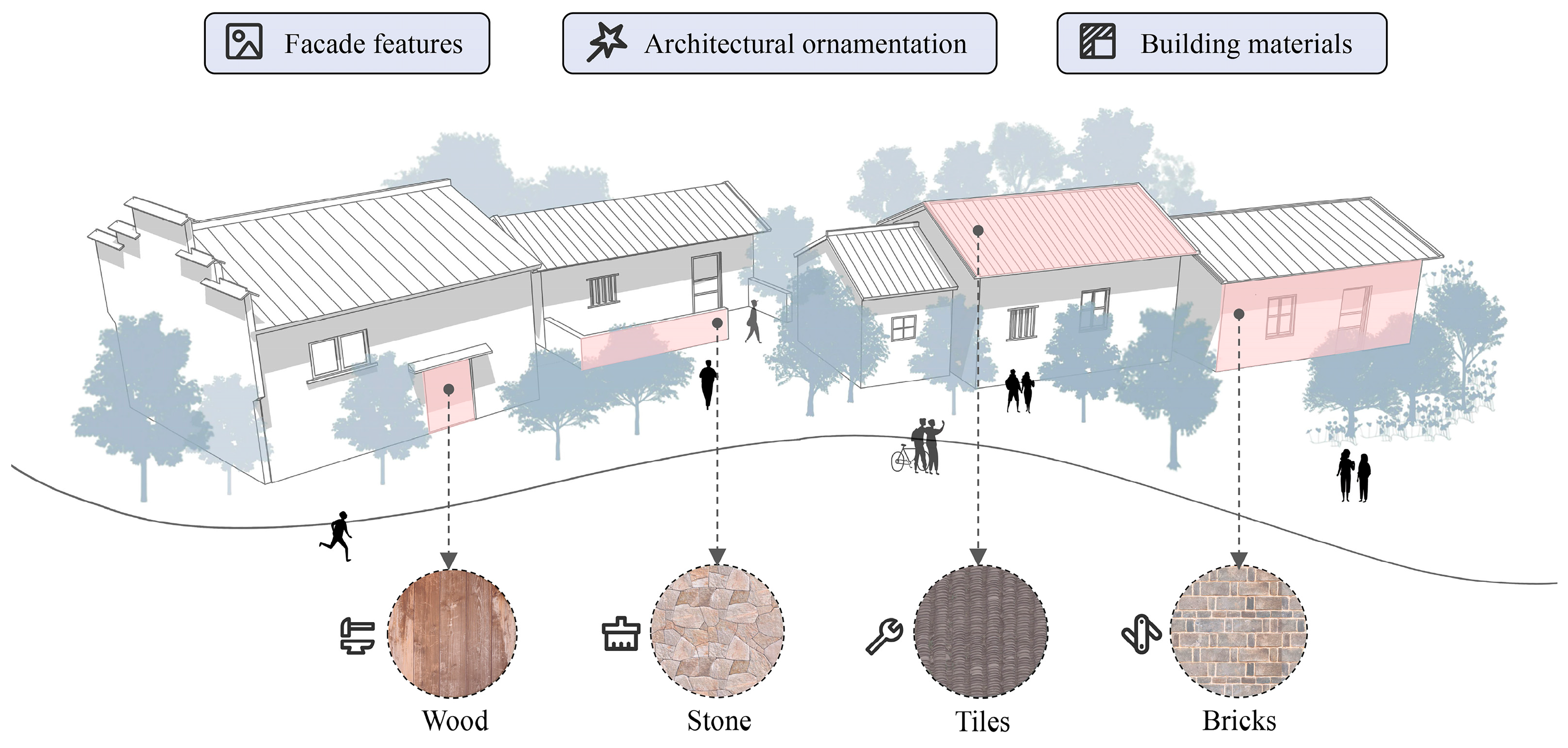
Buildings, as central carriers of daily life and public activities, establish close sensory and emotional connections with residents and visitors [78], with their evaluations primarily focusing on exterior features, such as facade features [79], architectural ornamentation [80], and building materials [15]. Residents and visitors reported low perception scores for the building form, roof form, facade features of Huangtutang Village, indicating that the continuity and integrity of the village’s overall architectural character have been partially compromised. Therefore, in the process of updating the architectural style of Huangtutang Village, the preservation of original building features [81], particularly facade features, architectural ornamentation, and building materials, should be prioritized to ensure the continuity of architectural integrity [5]. A comprehensive and detailed architectural survey should be conducted for Huangtutang Village, systematically analyzing the construction periods, stylistic features, cultural value, and preservation status of the buildings. Based on the current conditions of the existing buildings, practical protection and restoration plans should be developed. For severely damaged buildings, timely repairs should be implemented, such as restoring window frames, door decorations, carvings, roof tiles, and ceramic embellishments. Regular inspections of exposed wooden columns should also be conducted, with appropriate anti-corrosion treatments applied to ensure structural stability and long-term preservation. During restoration, it is essential to preserve the original appearance of building facades, strictly adhere to traditional techniques, and prioritize materials identical or similar to the originals to maintain historical continuity and cultural authenticity. Additionally, elements associated with architectural heritage, such as interior furniture and furnishings, should also be considered integral parts of the building’s historical fabric and be given priority for preservation and appropriate restoration to sustain their cultural value and historical memory. To enhance the professionalism and effectiveness of preservation efforts, extensive collaboration among public institutions, universities, and villages should be promoted, particularly by attracting private investment to participate in the protection of rural architecture in traditional villages [82]. This collaborative model not only improves the professionalism of preservation projects but also injects sustainable momentum into the protection and development of Huangtutang Village’s architectural heritage (Figure 9).

5.1.4. Continuation of Diverse Historical Contexts

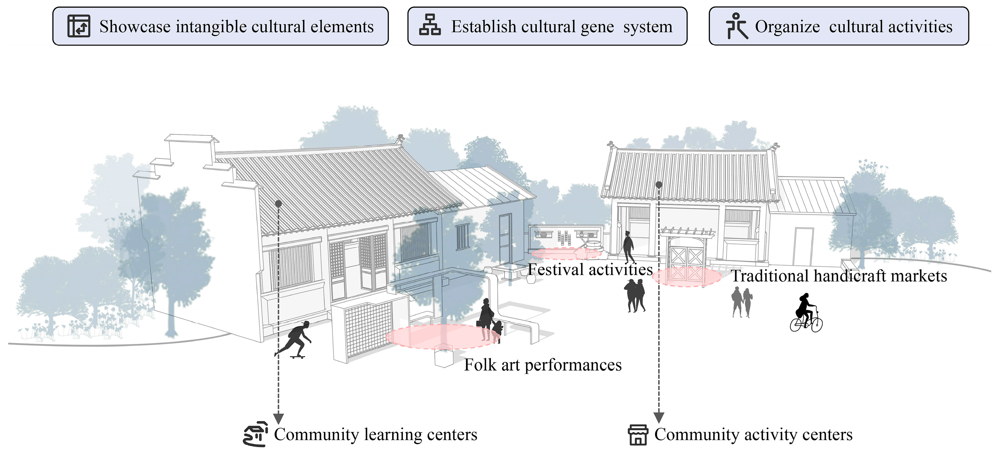
The intangible cultural landscape gene is a core element of the cultural landscape of traditional villages, playing a vital role in rural revitalization, cultural heritage, and preservation [83]. As a living entity, Huangtutang Village embodies unique historical, cultural, and social characteristics, which constitute its irreplaceable core value. Residents and visitors assigned low perception scores for the indicators of folk tales and historical and cultural context in Huangtutang Village, indicating weak transmission of the village’s cultural memory. Therefore, in the process of protecting and developing Huangtutang Village, attention must be paid not only to safeguarding its physical environmental elements but also to establishing an effective mechanism for preserving and passing down its intangible cultural elements. As discussed by Li et al. [84], systematically organizing and presenting intangible cultural elements can enhance the cultural appeal and cohesion of villages, thereby promoting cultural heritage and sustainable community development. Therefore, in-depth research and exploration of Huangtutang Village’s historical origins, anecdotes of famous figures, folk tales, historical and cultural context, and local customs and traditions should be conducted. This should be combined with geographic information technology to construct a visualized management system for cultural genes. Utilizing diverse media forms such as text, images, videos, and audio recordings, cultural genes should be systematically stored and showcased to establish standardized cultural gene archives. Additionally, idle village spaces can be converted into resident schools or community activity centers. These can host cultural activities such as festivals, folk art performances, and traditional craft markets to showcase and pass down Huangtutang Village’s customs [85], thereby enhancing residents’ and visitors’ understanding and recognition of the village’s cultural genes. Especially by integrating traditional cultural activities with local culinary specialties, the authenticity of traditional cultural forms can be preserved while meeting modern audiences’ diverse demands for regional cultural experiences, thus achieving the revitalization and continuation of traditional culture in contemporary contexts (Figure 10).

5.2. Applications and Contributions of Landscape Gene Perception Evaluation for Traditional Villages

Research on traditional village landscape genes provides an essential complement to the conservation and development of traditional villages. As key carriers of historical and cultural heritage, traditional villages contain landscape genes that embody local characteristics, historical memory, and cultural traditions, and that shape residents’ lifestyles and social practices. In the process of traditional village conservation and development, research on landscape genes offers a novel perspective for systematically identifying and extracting critical elements such as ecology, architecture, and culture, thereby effectively guiding scientific planning and rational conservation. However, previous studies in this field have predominantly focused on the identification [86], extraction, and expression of landscape genes [87], while largely neglecting the systematic evaluation of landscape gene perception—an equally critical dimension for the sustainable development of traditional villages.
Landscape gene perception evaluation systematically reflects the quality of traditional village landscapes and the experiential perceptions of residents and visitors. Perception evaluation objectively reveals the strengths and weaknesses of traditional village landscapes, reflecting actual experiences and satisfaction levels, thereby providing data support and references for conservation and development planning decisions. This research, based on the theoretical framework of landscape genes, constructed a landscape gene map and perception evaluation system for Huangtutang Village, employing a combined weighting method via game theory and cloud modeling for a comprehensive evaluation of the village’s landscape genes. Compared to existing studies, this research demonstrates notable innovation in both its evaluation methods and framework. By addressing uncertainties through game-theory-based weighting and cloud modeling, this research overcomes the limitations of randomness and vagueness in traditional evaluation models, producing more scientific and precise results to support comprehensive and reliable decision-making for village conservation and development. The case analysis of Huangtutang Village validates the feasibility and effectiveness of landscape gene perception evaluation in practical applications. Through comprehensive analysis of field surveys and perception data, this research demonstrates the broad applicability of the perception evaluation system in the conservation and development of traditional villages. In summary, this research introduces a novel framework for evaluating the perception of traditional village landscape genes, expanding the depth and breadth of landscape gene research, advancing theoretical development, and offering valuable references for similar studies and conservation practices in traditional villages.

6. Conclusions

This research developed a landscape gene map and perception evaluation framework for Huangtutang Village, covering four levels: environmental pattern, spatial layout characteristics, architectural character, and cultural characteristics, with a total of twenty indicators. Using a combined weighting approach based on game theory and the cloud model, we conducted a comprehensive assessment of the importance and perception characteristics of the village’s landscape genes and proposed targeted conservation and development strategies. The results indicate that architectural ornamentation, facade features, environmental features, local customs and traditions, roof form and street layout play a particularly critical role in the conservation and utilization of the village’s landscape genes. Visualization through the cloud model further reveals that residents and visitors generally reported perceptions close to “Satisfied,” with scores ranked from highest to lowest as environmental pattern, cultural characteristics, architectural character and spatial layout characteristics. Some indicators, such as traffic location, topography and landform, street texture, building form, roof form, facade features, folk tales and historical and cultural context, received relatively low expectation scores, highlighting areas requiring urgent attention and improvement. This research introduces a novel framework for evaluating the perception of landscape genes in traditional villages, addressing limitations of randomness and vagueness in previous models. The results offer more precise and scientifically robust evaluations, with implications for both theoretical advancement and practical conservation. Given that Huangtutang Village exemplifies the water-town landscape and cultural characteristics of the Jiangnan region, the findings provide a transferable methodological framework for the conservation of similar villages across southeastern China. However, this study is limited to a single village and lacks cross-regional comparative analysis. In areas with markedly different natural environments and historical contexts, such as northern mountain villages or minority settlements, the indicator system will require local adaptation. Future research should expand the sample scope to include a broader range of representative villages in order to test the generalizability and robustness of the method and to uncover both commonalities and differences in landscape genes across regions.

Author Contributions

X.L. was responsible for conceptualization, data collection and quality, and formal analysis. R.Z. was responsible for editing the manuscript. S.C. was responsible for interpretation, visualization and methods. L.Y. was responsible for translation and collecting relevant data. R.B. was responsible for data analysis and provided methodological guidance for the manuscript. All authors have read and agreed to the published version of the manuscript.

Funding

This research was funded by the National Foreign Experts Project: Research on Cultural Inheritance and Innovative Development in Urban Regeneration, grant number B20240686.

Data Availability Statement

The datasets used and analyzed during the current study are available from the corresponding author upon reasonable request.

Acknowledgments

We sincerely thank the reviewers for their constructive comments and the editor for the valuable improvements made to the manuscript. We also wish to express our gratitude to Sitong Li for her support and assistance, which have been instrumental in enhancing the quality of this paper.

Conflicts of Interest

The authors declare no competing interests.

Appendix A

Table A1. Comprehensive Weight Values of Evaluation Indicators.
Target LayerCriterion LayerFactor LayerSubjective WeightObjective WeightCombined Weight
Landscape Gene Perception Evaluation System for Huangtutang VillageB1 Environmental patternC1 Topography and landform0.02710.06580.0534
C2 Watercourse system0.0360.06840.0580
C3 Traffic location0.02310.04150.0356
C4 Environmental features0.05750.10280.0882
B2 Spatial layout characteristicsC5 Village morphology0.06620.05370.0577
C6 Building distribution0.04440.01950.0275
C7 Street layout0.06790.05760.0609
C8 Street texture0.03340.01710.0224
B3 Architectural characterC9 Building form0.05950.01140.0269
C10 Facade features0.10820.08100.0898
C11 Roof form0.06510.06090.0623
C12 Architectural ornamentation0.10810.09300.0979
C13 Building materials0.05960.05270.0549
C14 Building colors0.04790.04630.0468
B4 Cultural characteristicsC15 Anecdotes of famous figures0.03130.01270.0186
C16 Folk tales0.02790.04420.0390
C17 Historical and cultural context0.03110.03920.0366
C18 Local customs and traditions0.05180.10510.0880
C19 Traditional cuisine0.01960.02220.0214
C20 Clan surnames0.03430.00470.0142
Table A2. Cloud Model Parameters for the Landscape Gene Perception Evaluation of Huangtutang Village.
Indicators E x E n H e Weight
B1 Environmental pattern79.0257.4241.3100.2352
B2 Spatial layout characteristics70.9905.8811.4270.1685
B3 Architectural character73.6128.1382.0420.3785
B4 Cultural characteristics75.7599.4431.7250.2173
C1 Topography and landform75.0437.8751.7200.0534
C2 Watercourse system77.6536.772.2560.0580
C3 Traffic location81.3617.3840.7320.0356
C4 Environmental features76.1398.0661.8100.0882
C5 Village morphology79.5097.5880.9550.0577
C6 Building distribution73.9125.3491.2300.0275
C7 Street layout71.2595.8001.4490.0609
C8 Street texture70.0975.3411.3650.0224
C9 Building form67.6768.8271.8170.0269
C10 Facade features70.7089.2612.6890.0898
C11 Roof form73.5698.0071.3440.0623
C12 Architectural ornamentation72.3848.1101.9970.0979
C13 Building materials74.5377.9792.2070.0549
C14 Building colors74.6308.4702.2610.0468
C15 Anecdotes of famous figures74.1027.7312.4100.0186
C16 Folk tales75.3338.1121.6070.0390
C17 Historical and cultural context74.44410.4202.2960.0366
C18 Local customs and traditions75.1259.5452.9790.0880
C19 Traditional cuisine76.3619.2140.9430.0214
C20 Clan surnames76.94410.2931.8070.0142
Target layer75.0437.8751.721.0000

References

  1. Setijanti, P.; Defiana, I.; Setyawan, W.; Silas, J.; Firmaningtyas, S.; Ernawati, R. Traditional settlement livability in creating sustainable living. Procedia-Soc. Behav. Sci. 2015, 179, 204–211. [Google Scholar] [CrossRef][Green Version]
  2. Tang, C.; Yang, Y.; Liu, Y.; Xiao, X. Comprehensive evaluation of the cultural inheritance level of tourism-oriented traditional villages: The example of Beijing. Tour. Manag. Perspect. 2023, 48, 101166. [Google Scholar] [CrossRef]
  3. Huang, Y.; Zhang, C.; Xiang, H.; Xiang, X.; Liu, X.; Chen, J. Development types and design guidelines for the conservation and utilization of spatial environment in traditional villages in Southern China. J. Asian Archit. Build. Eng. 2024, 23, 1699–1716. [Google Scholar] [CrossRef]
  4. Liu, S.; Ge, J.; Bai, M.; Yao, M.; He, L.; Chen, M. Toward classification-based sustainable revitalization: Assessing the vitality of traditional villages. Land Use Policy 2022, 116, 106060. [Google Scholar] [CrossRef]
  5. Fu, J.; Zhou, J.; Deng, Y. Heritage values of ancient vernacular residences in traditional villages in Western Hunan, China: Spatial patterns and influencing factors. Build. Environ. 2021, 188, 107473. [Google Scholar] [CrossRef]
  6. Hu, Z.; Liu, P.; Tan, M. Cultural landscape genome maps: A scientific language perspective of traditional settlements. Sci. Geogr. Sin. 2024, 44, 1309–1321. [Google Scholar]
  7. Long, T.; Ișık, C.; Yan, J.; Zhong, Q. Promoting the sustainable development of traditional villages: Exploring the comprehensive assessment, spatial and temporal evolution, and internal and external impacts of traditional village human settlements in hunan province. Heliyon 2024, 10, e32439. [Google Scholar] [CrossRef]
  8. Xi, X.; Xu, H.; Zhao, Q.; Zhao, G. Making rural micro-regeneration strategies based on resident perceptions and preferences for traditional village conservation and development: The case of Huangshan Village, China. Land 2021, 10, 718. [Google Scholar] [CrossRef]
  9. Li, J.; Jin, T.; Xiang, W.; Huang, Q. Exploring the dynamic evolutionary mechanism of game model on the protection of traditional villages. Reg. Sustain. 2022, 3, 188–207. [Google Scholar] [CrossRef]
  10. Yang, Q. Research on the changes in cultural landscape of tourist-type traditional Chinese villages from the perspective of cultural memory: Taking Anzhen Village in Chongqing as an example. Land 2023, 12, 816. [Google Scholar] [CrossRef]
  11. Wang, H.; Shan, Y.; Xia, S.; Cao, J. Traditional village morphological characteristics and driving mechanism from a rural sustainability perspective: Evidence from Jiangsu Province. Buildings 2024, 14, 1302. [Google Scholar] [CrossRef]
  12. Ma, Y.; Zhang, Q.; Huang, L. Spatial distribution characteristics and influencing factors of traditional villages in Fujian Province, China. Humanit. Soc. Sci. Commun. 2023, 10, 883. [Google Scholar] [CrossRef]
  13. Tang, C.; Liu, Y.; Wan, Z.; Liang, W. Evaluation system and influencing paths for the integration of culture and tourism in traditional villages. J. Geogr. Sci. 2023, 33, 2489–2510. [Google Scholar] [CrossRef]
  14. Gao, J.; Wu, B. Revitalizing traditional villages through rural tourism: A case study of Yuanjia Village, Shaanxi Province, China. Tour. Manag. 2017, 63, 223–233. [Google Scholar] [CrossRef]
  15. Xu, L.; Sang, K.; Li, G.; Lin, G.; Luo, Q.; Giordano, A. Heritage evaluation and analysis based on entropy weight method: The study of Wengji ancient village in China. J. Hous. Built Environ. 2023, 38, 1843–1868. [Google Scholar] [CrossRef]
  16. Du, X.; Shi, D. Rural heritage: Value, conservation and Revitalisation—From the perspective of the human-land relationship. Built Herit. 2019, 3, 1–6. [Google Scholar] [CrossRef]
  17. Chen, C.; She, Y.; Chen, Q.; Liu, S. Study on ecological adaptability of traditional village construction in Hainan volcanic areas. J. Asian Archit. Build. Eng. 2023, 22, 494–512. [Google Scholar] [CrossRef]
  18. Zeng, Z.; Li, L.; Pang, Y. Analysis on climate adaptability of traditional villages in Lingnan, China--World Cultural Heritage Site of Majianglong Villages as example. Procedia Eng. 2017, 205, 2011–2018. [Google Scholar] [CrossRef]
  19. Chu, Y.C.; Hsu, M.F.; Hsieh, C.M. An example of ecological wisdom in historical settlement: The wind environment of Huazhai village in Taiwan. J. Asian Archit. Build. Eng. 2017, 16, 463–470. [Google Scholar] [CrossRef]
  20. Fang, Q.; Li, Z. Cultural ecology cognition and heritage value of huizhou traditional villages. Heliyon 2022, 8, 12. [Google Scholar] [CrossRef]
  21. Li, M.; Cao, Y.; Li, G. An approach to developing and protecting linear heritage tourism: The construction of cultural heritage corridor of traditional villages in Mentougou District using GIS. Int. J. Geoheritage Parks 2023, 11, 607–623. [Google Scholar] [CrossRef]
  22. Dogan, M. Ecomuseum, community museology, local distinctiveness, Hüsamettindere village, Bogatepe village, Turkey. J. Cult. Herit. Manag. Sustain. Dev. 2015, 5, 43–60. [Google Scholar] [CrossRef]
  23. Liu, P.L. On Construction and Utilization of Chinese Traditional Settlements Landscape’s Genetic Map. Ph.D. Thesis, Peking University, Beijing, China, 2011. (In Chinese). [Google Scholar]
  24. Fei, X.; Cheng, Y.; Kong, X.; Zhang, J. Cultural landscapes recognition and landscape genetic information chain analysis of traditional villages: A case study of Tanka Fishing village in Lingshui Li autonomous county. J. Nat. Resour. 2024, 39, 1760–1779. [Google Scholar] [CrossRef]
  25. Cao, K.; Liu, Y.; Cao, Y.; Wang, J.; Tian, Y. Construction and characteristic analysis of landscape gene maps of traditional villages along ancient Qin-Shu roads, Western China. Herit. Sci. 2024, 12, 37. [Google Scholar] [CrossRef]
  26. Liu, P.; Zeng, C.; Liu, R. Environmental adaptation of traditional Chinese settlement patterns and its landscape gene mapping. Habitat Int. 2023, 135, 102808. [Google Scholar] [CrossRef]
  27. Dang, A.; Zhao, D.; Chen, Y.; Wang, C. Conservation of cave-dwelling village using Cultural Landscape Gene Theory. In Spatial Synthesis: Computational Social Science and Humanities; Springer: Cham, Switzerland, 2020; pp. 97–105. [Google Scholar]
  28. Li, B.; Yang, F.; Long, X.; Liu, X.; Cheng, B.; Dou, Y. The organic renewal of traditional villages from the perspective of logical space restoration and physical space adaptation: A case study of Laoche village, China. Habitat Int. 2024, 144, 102988. [Google Scholar] [CrossRef]
  29. Hu, Z.; Tan, M. A parameter to featuring the cultural landscape genes of traditional settlements in China: A perspective of geographical information. Herit. Sci. 2024, 12, 140. [Google Scholar] [CrossRef]
  30. Liu, S.; Wu, L.; Xiang, C.; Dai, W. Revitalizing rural landscapes: Applying cultural landscape gene theory for sustainable spatial planning in Linpu Village. Buildings 2024, 14, 2396. [Google Scholar] [CrossRef]
  31. Hu, Z.; Liu, P.; Shen, X.; Liu, X.; Deng, Y.; Chen, Y. A Prototype Design of Gene Graphic Methodology for Ancient Village Landscapes Based on GIS. J. Geo-Inf. Sci. 2010, 12, 83–88. [Google Scholar] [CrossRef]
  32. Hu, Z.; Josef, S.; Min, Q.; Tan, M.; Cheng, F. Visualizing the cultural landscape gene of traditional settlements in China: A semiotic perspective. Herit. Sci. 2021, 9, 115. [Google Scholar] [CrossRef]
  33. Hu, Z.; Deng, Y.; Liu, P.; Peng, H. The semiotic mechanism of cultural landscape genes of traditional settlements. Acta Geogr. Sin. 2020, 75, 789–803. [Google Scholar]
  34. Liu, R.; Liu, P.; Shen, X.; Zhou, W. Effect of traditional village landscape genes on tourists’ image construction: Case study of Zhangguying Village. J. Resour. Ecol. 2024, 15, 587–600. [Google Scholar] [CrossRef]
  35. Li, G.; Chen, B.; Zhu, J.; Sun, L. Traditional Village research based on culture-landscape genes: A Case of Tujia traditional villages in Shizhu, Chongqing, China. J. Asian Archit. Build. Eng. 2024, 23, 325–343. [Google Scholar] [CrossRef]
  36. Zhang, Y.; Luo, X.; Xu, X.; Mak, K.; Ruan, D. Construction and Application of Cultural Gene Library of Ancestral Hall in Canton Region. Teh. Vjesn. 2024, 31, 993–1004. [Google Scholar]
  37. Zhou, J.; Xia, X.; Wu, S. Genetic characteristics evaluation and planning design of traditional village cultural landscape: Taking Dongmen Fishing Village in Xiangshan, Zhejiang Province as an example. J. Asian Archit. Build. Eng. 2025, 24, 4572–4588. [Google Scholar] [CrossRef]
  38. Sauer, C. The morphology of landscape. In The Cultural Geography Reader; Routledge: London, UK, 2008. [Google Scholar]
  39. Zeng, C.; Liu, P.; Huang, L.; Feng, S.; Li, Y. Features of architectural landscape fragmentation in traditional villages in Western Hunan, China. Sci. Rep. 2023, 13, 18633. [Google Scholar] [CrossRef]
  40. Li, W.; Zhou, Y.; Xun, G. Evaluation of rural landscape resources based on cloud model and probabilistic linguistic term set. Land 2022, 11, 60. [Google Scholar] [CrossRef]
  41. Wu, T.Y.; Lee, W.T.; Guizani, N.; Wang, T.M. Incentive mechanism for P2P file sharing based on social network and game theory. J. Netw. Comput. Appl. 2014, 41, 47–55. [Google Scholar] [CrossRef]
  42. Yang, B.; Lai, C.; Chen, X.; Wu, X.; He, Y. Surface water quality evaluation based on a game theory-based cloud model. Water 2018, 10, 510. [Google Scholar] [CrossRef]
  43. Li, D.; Liu, C.; Gan, W. A new cognitive model: Cloud model. Int. J. Intell. Syst. 2009, 24, 357–375. [Google Scholar] [CrossRef]
  44. Liang, R.; Wang, J.Q. A linguistic intuitionistic cloud decision support model with sentiment analysis for product selection in E-commerce. Int. J. Fuzzy Syst. 2019, 21, 963–977. [Google Scholar] [CrossRef]
  45. Wang, D.; Liu, D.; Ding, H.; Singh, V.P.; Wang, Y.; Zeng, X.; Wu, J.; Wang, L. A cloud model-based approach for water quality assessment. Environ. Res. 2016, 148, 24–35. [Google Scholar] [CrossRef]
  46. Lou, S.; Feng, Y.; Li, Z.; Zheng, H.; Tan, J. An integrated decision-making method for product design scheme evaluation based on cloud model and EEG data. Adv. Eng. Inform. 2020, 43, 101028. [Google Scholar]
  47. Du, X.; Ge, S.L.; Wang, N.X.; Yang, Z. Personalized product service scheme recommendation based on trust and cloud model. IEEE Access 2020, 8, 82581–82591. [Google Scholar] [CrossRef]
  48. Wu, H.W.; Zhen, J.; Zhang, J. Urban rail transit operation safety evaluation based on an improved CRITIC method and cloud model. J. Rail Transp. Plan. Manag. 2020, 16, 100206. [Google Scholar] [CrossRef]
  49. Liu, J.; Gong, E.; Wang, D.; Teng, Y. Cloud model-based safety performance evaluation of prefabricated building project in China. Wirel. Pers. Commun. 2018, 102, 3021–3039. [Google Scholar] [CrossRef]
  50. Fu, L.; Ding, M.; Zhang, Q. Flood risk assessment of urban cultural heritage based on PSR conceptual model with game theory and cloud model—A case study of Nanjing. J. Cult. Herit. 2022, 58, 1–11. [Google Scholar]
  51. Zhao, B.; Shao, Y.B.; Yang, C.; Zhao, C. The application of the game theory combination weighting-normal cloud model to the quality evaluation of surrounding rocks. Front. Earth Sci. 2024, 12, 1346536. [Google Scholar] [CrossRef]
  52. Pu, X. Talking About Huangtutang; Jiangsu People’s Publishing House: Nanjing, China, 2012. [Google Scholar]
  53. Liu, P.; Liu, C.; Deng, Y.; Shen, X.; Hu, Z.; Li, B. Study on ancient village’s protection and development which based on the concept of landscape-gene’s integrity. Econ. Geogr. 2009, 29, 1731–1736. [Google Scholar]
  54. Liu, P.; Dong, S. Study of landscape-image of Chinese ancient village. Geogr. Res. 1998, 17, 31–38. [Google Scholar]
  55. Liu, P. The Gene Expression and the Siqht ldentification ofthe Ancient Villages’ Cultural Landscape. J. Hengyang Norm. Univ. 2003, 4, 1–8. [Google Scholar]
  56. Liu, P. The Landscape and Genes of Home: An In-Depth Interpretation of the Landscape Gene Map of Traditional Settlements; Commercial Press: Beijing, China, 2014. [Google Scholar]
  57. Hu, Z.; Liu, P. The conceptual model and characterizations of landscape genome maps of traditional settlements in China. Acta Geogr. Sin. 2015, 70, 1592–1606. [Google Scholar]
  58. Huo, Y.; Liu, P. The Loess Plateau: Settlement Landscapes and Vernacular Culture; China Architecture and Building Press: Beijing, China, 2013. [Google Scholar]
  59. Hu, Z.; Liu, P.; Deng, Y.; Zheng, W. A novel method for identifying and separating landscape genes from traditional settlements. Sci. Geogr. Sin. 2015, 35, 1518–1524. [Google Scholar]
  60. Saaty, T.L. The analytic hierarchy process (AHP). J. Oper. Res. Soc. 1980, 41, 1073–1076. [Google Scholar]
  61. Poveda, C.A.; Lipsett, M.G. A review of sustainability assessment and sustainability/environmental rating systems and credit weighting tools. J. Sustain. Dev. 2011, 4, 36. [Google Scholar] [CrossRef]
  62. Peng, T.; Deng, H. Evaluating urban resource and environment carrying capacity by using an innovative indicator system based on eco-civilization—A case study of Guiyang. Environ. Sci. Pollut. Res. 2021, 28, 6941–6955. [Google Scholar] [CrossRef] [PubMed]
  63. Li, Q.; Liu, Z.; Yang, Y.; Han, Y.; Wang, X. Evaluation of water resources carrying capacity in Tarim River Basin under game theory combination weights. Ecol. Indic. 2023, 154, 110609. [Google Scholar] [CrossRef]
  64. Chen, S.; Zhu, X.; Zhou, Y.; Yan, Y.; Wang, R.; Han, P. Measurement of water resources carrying capacity in Gugang Town of Central China based on human-water-agriculture framework. Sci. Total Environ. 2023, 881, 163459. [Google Scholar] [CrossRef]
  65. Dai, R.; Xiao, C.; Liang, X.; Yang, W.; Chen, J.; Zhang, L.; Zhang, J.; Yao, J.; Jiang, Y.; Wang, W. Spatial-temporal evolution law analysis of resource and environment carrying capacity based on game theory combination weighting and GMD-GRA-TOPSIS model. Evidence from 18 cities in Henan Province, China. J. Clean. Prod. 2024, 439, 140820. [Google Scholar] [CrossRef]
  66. Li, D. Membership clouds and membership cloud generators. Comput. Res. Dev. 1995, 32, 15–20. [Google Scholar]
  67. Wei, C.; Meng, J.; Zhu, L.; Han, Z. Assessing progress towards sustainable development goals for Chinese urban land use: A new cloud model approach. J. Environ. Manag. 2023, 326, 116826. [Google Scholar] [CrossRef]
  68. Li, R.; Zhang, Y.; Li, W.; Xu, X. Identification model of traditional village cultural landscape elements and its application from the perspective of living heritage—A case study of Chentian Village in Wuhan. Buildings 2024, 14, 3535. [Google Scholar] [CrossRef]
  69. Zhou, Y.; Liu, M.; Xie, G.; Liu, C. Landscape ecology analysis of traditional villages: A case study of Ganjiang River Basin. Appl. Sci. 2024, 14, 929. [Google Scholar] [CrossRef]
  70. Chen, X.; Xie, W.; Li, H. The spatial evolution process, characteristics and driving factors of traditional villages from the perspective of the cultural ecosystem: A case study of Chengkan Village. Habitat Int. 2020, 104, 102250. [Google Scholar] [CrossRef]
  71. Chen, Z.; Yang, H.; Lin, Y.; Xie, J.; Xie, Y.; Ding, Z. Exploring the association between the built environment and positive sentiments of tourists in traditional villages in Fuzhou, China. Ecol. Inform. 2024, 80, 102465. [Google Scholar] [CrossRef]
  72. Shen, H.; Aziz, N.F.; Huang, M.; Yu, L.; Liu, Z. Tourist perceptions of landscape in Chinese traditional villages: Analysis based on online data. J. Tour. Cult. Chang. 2024, 22, 232–251. [Google Scholar] [CrossRef]
  73. Jiang, S.; Ma, H.; Yang, L.; Luo, S. The influence of perceived physical and aesthetic quality of rural settlements on tourists’ preferences—A case study of zhaoxing dong village. Land 2023, 12, 1542. [Google Scholar] [CrossRef]
  74. Wang, X.; Jin, X.; Feng, Y. Landscape reconstruction of traditional village couplets based on image recognition algorithm. J. Opt. 2023, 52, 224–232. [Google Scholar] [CrossRef]
  75. Pei, Y.; Gong, K.; Leng, J. Study on the inter-village space of a traditional village group in Huizhou Region: Hongguan Village group as an example. Front. Archit. Res. 2020, 9, 588–605. [Google Scholar] [CrossRef]
  76. Liu, Y.; Li, Z.; Tian, Y.; Gao, B.; Wang, S.; Qi, Y.; Zou, Z.; Li, X.; Wang, R. A study on identifying the spatial characteristic factors of traditional streets based on visitor perception: Yuanjia Village, Shaanxi Province. Buildings 2024, 14, 1815. [Google Scholar] [CrossRef]
  77. Saleh, M.A.E. The architectural form and landscape as a harmonic entity in the vernacular settlements of Southwestern Saudi Arabia. Habitat Int. 2000, 24, 455–473. [Google Scholar] [CrossRef]
  78. Lu, X.; Tan, D.; Zhou, Y.; Xie, Y.; Chen, Z. Traditional village perception and protection behavior: The mediating role of local identity and the impact of different population differences. J. Asian Archit. Build. Eng. 2024, 1–18. [Google Scholar] [CrossRef]
  79. Cheng, G.; Li, Z.; Xia, S.; Gao, M.; Ye, M.; Shi, T. Research on the spatial sequence of building facades in huizhou regional traditional villages. Buildings 2023, 13, 174. [Google Scholar] [CrossRef]
  80. Kang, N.; Liu, C. Assessment of visual quality and social perception of cultural landscapes: Application to Anyi traditional villages, China. Heritage Science. 2024, 12, 235. [Google Scholar] [CrossRef]
  81. Zhao, Y.; Zhan, Q.; Du, G.; Wei, Y. The effects of involvement, authenticity, and destination image on tourist satisfaction in the context of Chinese ancient village tourism. J. Hosp. Tour. Manag. 2024, 60, 51–62. [Google Scholar] [CrossRef]
  82. Zhou, M.; Chu, S.; Du, X. Safeguarding traditional villages in China: The role and challenges of Rural Heritage preservation. Built Herit. 2019, 3, 81–93. [Google Scholar] [CrossRef]
  83. Yang, L.; Hu, Y. Production and inheritance of intangible cultural landscape gene in traditional villages: A case study of Huangdu village in Tongdong autonomous county. Econ. Geogr. 2022, 42, 208–215. [Google Scholar]
  84. Li, Q.; Lv, S.; Chen, Z.; Cui, J.; Li, W.; Liu, Y. Traditional Villages’ Cultural Tourism Spatial Quality Evaluation. Sustainability 2024, 16, 7752. [Google Scholar] [CrossRef]
  85. Qin, R.J.; Leung, H.H. Becoming a traditional village: Heritage protection and livelihood transformation of a Chinese village. Sustainability 2021, 13, 2331. [Google Scholar] [CrossRef]
  86. Wang, W.; Shi, Q.; Wang, G. Exploration of the landscape gene characteristics of traditional villages along the Jinzhong section of the Wanli Tea Road from the perspective of the village temple system. Land 2024, 13, 1602. [Google Scholar] [CrossRef]
  87. Fan, J.; Zheng, B.; Zhang, B.; Huang, Z.; Liu, J. Research on the Revitalization Path of Ethnic Villages Based on the Inheritance of Spatial Cultural Genes—Taking Tujia Village of Feng Xiang Xi in Guizhou Province as a Case Study. Sustainability 2023, 15, 1303. [Google Scholar] [CrossRef]
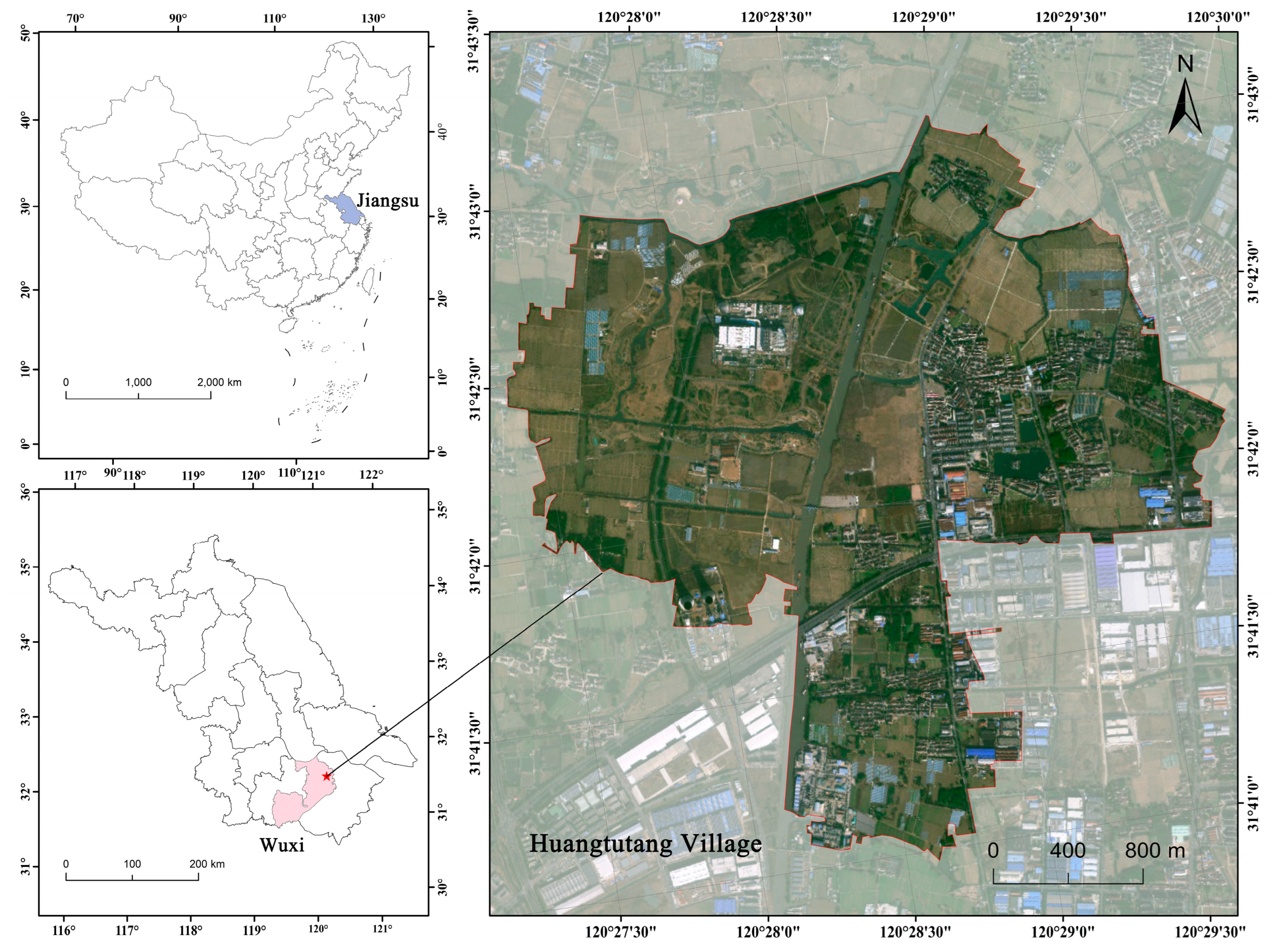
Figure 1. Geographic location of Huangtutang Village. Note: The red star marks the location of Huangtutang Village in the study area.
Buildings 15 03441 g001
Figure 2. Landscape gene map of Huangtutang Village.
Buildings 15 03441 g002
Figure 3. Perceptual evaluation system for the landscape genes of Huangtutang Village.
Buildings 15 03441 g003
Figure 4. Standard cloud map for the perceptual evaluation of landscape genes. Note: The five curves (orange, blue, green, purple, and cyan) represent the standard membership functions for the categories “very dissatisfied,” “dissatisfied,” “neutral,” “satisfied,” and “very satisfied”.
Buildings 15 03441 g004
Figure 5. Comprehensive cloud map for the perceptual evaluation of landscape genes in Huangtutang Village. Note: The five curves (orange, blue, green, purple, and cyan) represent the standard membership functions for the categories “very dissatisfied,” “dissatisfied,” “neutral,” “satisfied,” and “very satisfied.” The red curve depicts respondents’ overall perceptual evaluation of the landscape genes of Huangtutang Village.
Buildings 15 03441 g005
Figure 6. Cloud map of perceptual evaluation for the landscape genes in Huangtutang Village. Note: The five curves (orange, blue, green, purple, and cyan) represent the standard membership functions for the categories “very dissatisfied,” “dissatisfied,” “neutral,” “satisfied,” and “very satisfied.” The red evaluation cloud depicts the actual distribution of respondents’ assessments, capturing both the central tendency (cloud center) and the degree of divergence and uncertainty (cloud spread). The x-axis denotes the overall rating (0–100), while the y-axis represents the membership degree (0–1).
Buildings 15 03441 g006
Figure 7. Restoration of damaged ecological environments.
Buildings 15 03441 g007
Figure 8. Repairing fragmented historical textures.
Buildings 15 03441 g008
Figure 9. Preservation and inheritance of architectural heritage.
Buildings 15 03441 g009
Figure 10. Continuation of diverse historical contexts.
Buildings 15 03441 g010
Table 1. Presents the values of the average random consistency index R . I .
Order of the Matrix123456
R.I.000.520.891.121.24
Table 2. Classification of Evaluation Standard Levels and Corresponding Cloud Models.
Landscape Gene Perception Evaluation LevelsGrade IntervalsCloud Model Characteristic Parameters
Very dissatisfied[0.0, 25.0)(12.5, 4.1667, 0.01)
Dissatisfied[25.0, 50.0)(37.5, 4.1667, 0.01)
Neutral[50.0, 75.0)(62.5, 4.1667, 0.01)
Satisfied[75.0, 90.0)(82.5, 2.5, 0.01)
Very satisfied[90.0, 100.0](95.0, 1.1667, 0.01)
Disclaimer/Publisher’s Note: The statements, opinions and data contained in all publications are solely those of the individual author(s) and contributor(s) and not of MDPI and/or the editor(s). MDPI and/or the editor(s) disclaim responsibility for any injury to people or property resulting from any ideas, methods, instructions or products referred to in the content.