Article

Recovery of Public Spaces on the Banks of the Ichu River and Environmental Awareness in Huancavelica, Peru

1
University Graduate School, Federico Villarreal National University, Lima 15088, Peru
2
Faculty of Geographical, Environmental and Ecotourism Engineering, Federico Villarreal National University, Lima 15088, Peru
*
Author to whom correspondence should be addressed.
Buildings 2025, 15(17), 3120; https://doi.org/10.3390/buildings15173120
Submission received: 10 November 2024 / Revised: 4 June 2025 / Accepted: 22 July 2025 / Published: 1 September 2025

Abstract

The objective of this research is to design sustainable public spaces along the banks of the Ichu River in Huancavelica, Peru, with the aim of promoting environmental awareness within the local community. The identified problem lies in the deterioration of these spaces and the limited environmental awareness among the population. The applied methodology includes both macro- and micro-scale analyses of the study area, as well as the use of bioclimatic maps to incorporate passive strategies, clean technologies, and the use of local and ecological materials. The proposed hypothesis states that if sustainable public spaces are designed by integrating bioclimatic strategies, clean technologies, and local materials, then environmental awareness among the population will be strengthened, the quality of life of residents will improve, and the economic and social development of Huancavelica will be promoted. The results show that the implementation of sustainable infrastructure such as roads, parks, a riverside promenade with local product fairs, and a tourist dock can significantly contribute to improving the urban and natural environment. Additionally, the creation of an ecomuseum with sensory gardens is proposed to encourage social inclusion. In conclusion, the design of these spaces not only supports the conservation of the local ecosystem through actions such as reforestation and sustainable rainwater drainage but also strengthens the sense of community belonging and boosts economic development through neighborhood markets and responsible tourism activities, thereby improving the relationship between the community and its natural environment.

1. Introduction

The world’s rivers are essential components for both human and environmental development [1,2]. They host a remarkable diversity of wildlife and serve as the primary habitats for various fish species, with an annual catch of 12 million tons [3]. Rivers generally provide drinking water to around two billion people; in some cases, they are the sole source of life in certain regions, where they flow into and form geographical features known as river deltas [4]. Additionally, rivers are crucial for global agricultural irrigation, covering approximately 190 million hectares [5].
Despite their great importance, at least half of the world’s major rivers have been contaminated over time due to human activity [6], mainly from the discharge of untreated wastewater [7]. Rivers are responsible for transporting approximately 90% of the pollutants that reach the oceans [8], which has led to irreversible damage in many coastal areas [9]. River pollution represents a serious environmental issue, with direct repercussions for the health of all living beings and the environment as a whole [8].
This issue is reflected in Sustainable Development Goal (SDG) No. 6, which recognizes water pollution as a critical challenge for the near future, setting targets for 2030 [10,11,12]. Over the past 20 years, the amount of freshwater available per person has decreased by 20% [13]. The causes of this water scarcity are diverse, with one of the main drivers being the overexploitation of water resources in the agricultural sector, which accounts for nearly 70% of global water withdrawals [14]. It is estimated that, by 2050, nearly seven billion people will be affected by this worsening problem known as water scarcity.
In Latin America, rivers are in a critical state, as most of them are used as reservoirs for wastewater and solid waste, including plastics and food scraps [15,16,17]. In the case of Peru, the rivers are divided into three major drainage basins: the Pacific watershed, the Amazon watershed, and the Lake Titicaca watershed [18]. In the capital city, there are three main rivers, known collectively as CHIRILU, referring to the Chillón, Rímac, and Lurín rivers, which supply drinking water to Lima [19]. The Rímac River, for example, is contaminated with several heavy metals, including lead, arsenic, and copper, at concentrations that exceed acceptable limits [20].
In this context, the Ichu River, located in the high Andes of Peru—specifically, in the department of Huancavelica—plays a crucial role in the regional economy. Its source is in the Chonta Glacier, and its watershed is composed of the Cachimayo and Atobamba rivers [21], eventually flowing into the larger Mantaro River basin. The significance of the Ichu River lies in the various economic activities that it supports along its course. In the upper regions, livestock farming is the primary economic activity of the surrounding communities, while, in the lower areas through which the river flows, agriculture predominates [22]. This underscores the importance of the Ichu River in sustaining the livelihoods of the population in Huancavelica, highlighting its essential role in the region’s productive structure [23].
The main activities are as follows [24]:
  • Agricultural Activity: Agriculture is fundamental in the lower part of the Ichu River sub-basin, particularly in small valleys, where gravity irrigation systems are used, mainly through user organizations. The most common crops include potatoes, barley, corn, fava beans (both dry and green), olluco, and choclo corn. Among these, potatoes, barley, and corn are the most representative, occupying the largest portions of cultivated land.
  • Livestock Activity: In the middle and upper parts of the basin, livestock farming is a key activity for producers in the Andean region, providing both income and employment. The most common species raised are cattle, sheep, pigs, and camelids.
  • Tourism: Huancavelica offers various tourist attractions, especially from historical, social, and cultural perspectives, with a particular emphasis on its colonial past and mercury mining activities.
The current situation of the Ichu River is alarming due to the large amount of waste polluting it—primarily organic waste, which is particularly harmful. The Ichu River has undergone considerable deterioration compared to its previous condition, as reflected by the fact that the municipal government of Huancavelica removes around 5 tons of garbage from the river each month. Approximately 70% of this waste is of domestic origin [25].
The Ichu River, which flows through the city of Huancavelica, shows a concerning level of contamination from heavy metals and urban discharges, affecting both the ecosystem and the health of the local population. Recent studies have identified the presence of heavy metals in the Ichu River, with concentrations that, in some cases, exceed the Environmental Quality Standards (ECA) for water in Peru.
These levels indicate significant contamination, especially in river sediments, where elevated concentrations of arsenic, cadmium, copper, lead, and mercury have been found. Figure 1 shows the following contamination levels:
  • Arsenic (As): between 0.0051 and 0.0066 mg/L;
  • Cadmium (Cd): less than 0.0004 mg/L;
  • Chromium (Cr): less than 0.02 mg/L;
  • Mercury (Hg): less than 0.001 mg/L;
  • Lead (Pb): between 0.0004 and 0.0048 mg/L [26].
The Ichu River shows poor water quality according to analyses conducted at six georeferenced sampling points. The samples, analyzed at RCJ Labs Universal, were assessed in terms of physical, chemical, and microbiological parameters, such as the biochemical oxygen demand, dissolved oxygen, fecal coliforms, nitrates, pH, temperature, total dissolved solids, total phosphates, and turbidity. The calculation of the Water Quality Index (WQI-NSF) yielded values between 27 and 32, placing the water in the range classified as poor quality, which highlights the river’s unfavorable environmental conditions [27].
During the survey of the urban section of the Ichu River, 37 contamination points were identified and categorized in [28]:
  • Household Sewage: There are 17 contamination points related to household sewage. Homes located near the river discharge their wastewater directly into the river through rudimentary or improvised pipes, as some lack a proper sewage system.
  • Gutter Discharge: Ten contamination points originate from gutter discharges. These gutters collect various types of water, including rainwater, and channel them into the river through the city streets. Runoff water, along with the water discharged from gutters, flows into the river at multiple locations across the city.
  • Stream Outflows: There are three stream outflow points. The first stream is contaminated with solid waste, as well as wastewater from residents washing clothes upstream. The second stream has a constant flow and passes through much of the city, accumulating solid waste and uncontrolled wastewater. The third stream also shows high degradation due to the presence of solid waste and clandestine sewage, worsened by laundry detergents, which intensify the pollution.
The Ichu River basin, located in a densely populated area, is experiencing increasing pollution due to the rapid urban development in districts such as Yauli and Ascensión. This growth has displaced natural resources, such as forests, and has worsened environmental problems. The lack of environmental awareness and the absence of an adequate wastewater treatment system have resulted in untreated water being discharged directly into the river. Additionally, there are illegal domestic drainage connections that release greywater and, in some cases, blackwater containing fecal matter and urine, further intensifying the contamination of the Ichu River [29]. The lack of proper waste disposal sites has turned the river into a dumping ground, where plastics, wood, and other debris are commonly found [30,31,32].
Green infrastructure designed for riverbanks plays a crucial role in raising environmental awareness and in the recovery of public spaces. This type of infrastructure integrates sustainable solutions that not only enhance the natural environment but also promote community awareness and participation in environmental conservation.
At the international level, conceptual green corridor projects in the coastal areas of Bahía de Banderas aim to reclaim the value of natural heritage and regenerate degraded urban spaces, demonstrating that urban planning and the restoration of segregated areas improve land use and functionality. Although these corridors provide environmental and ecosystem benefits, their integration into urban planning remains uncommon [33]. The proposed green corridors enhance environmental connectivity and transform degraded areas into public spaces, promoting a metropolitan model of integrated green infrastructure. This approach also addresses biodiversity connectivity, minimizes anthropogenic impacts, and offers social multifunctionality [34]. In Bahía de Banderas, green corridors are promoted through policies aimed at protecting coastal ecosystems and regulating ecotourism. Approximately 70% of the funding comes from federal and state public funds, with the remainder contributed by NGOs and ecotourism [35]. Public participation has been crucial, with 50–60% involvement from fishermen, tour operators, and local NGOs, ensuring that economic and environmental interests are balanced. This approach has led to an increase in marine biodiversity and the protection of key ecosystems.
In the international case of the Henares corridor, the green infrastructure (GI) proposal is approached from two complementary perspectives: ecosystem services and landscape ecology, focusing on the multifunctionality and connectivity of spaces. This GI includes natural areas and human-managed artificial elements, such as parks and greenways, and is organized into core areas, nodes, and connectors. The selection of elements for the Henares Corridor GI is based on spatial and digital information, with variations between regions. The elements are classified according to the local, regional, or supranational scale, ranging from urban parks to international watersheds. The associated ecosystem services include biodiversity conservation, the regulation of ecological processes, provisioning, and cultural services, highlighting the multifunctionality and complexity of the GI. This information can identify deficiencies and help to design corrective strategies for an integrated network that provides the expected services.
The Henares Corridor is based on sustainable urban planning and conservation policies, strongly supported by European funds to protect biodiversity and ecosystems. Approximately 40–50% of the financing comes from the European Union, with the remainder covered by local and regional public budgets. Public participation has been key, with municipalities involved in consultations and workshops alongside local communities and environmental groups. This collaboration has allowed the development of a project that addresses both urban and ecological needs. The impact has been positive, improving ecological connectivity and increasing biodiversity in restored areas. The sustainability of the project depends on maintaining collaboration between governments and the local community, which has proven essential for its success. Lessons learned indicate that involving all stakeholders from the beginning and ensuring continuous funding are fundamental.
The present research aims to design green infrastructure that facilitates the restoration of public spaces along the Ichu River, located in Huancavelica, Peru, as well as to promote environmental awareness in the region. This design seeks to integrate sustainable solutions for the rehabilitation of degraded areas, improving the quality of both the urban and natural environments throughout the river corridor. Additionally, it intends to implement strategies that strengthen the connection between residents and their natural surroundings, fostering greater environmental awareness and community participation. The proposal will include the planning of ecological corridors, reforestation with native species, and the creation of recreational and educational spaces that emphasize the importance of conserving the riverine ecosystem and its surroundings. In this context, the hypothesis is posed that, if green infrastructure is designed and implemented along the banks of the Ichu River incorporating these sustainable elements, then it will be possible to restore degraded areas both environmentally and functionally to improve the landscape and ecological quality of the urban—natural environment and reinforce the socioenvironmental bond between the local population and their river ecosystem. Moreover, it is expected that this intervention will help to foster sustainable practices, active citizen participation, and the appropriation of public space as a tool for social integration and territorial resilience in the face of climate change and environmental degradation.

2. Materials and Methods

This study is developed using a non-experimental approach, beginning with the collection of information from reliable academic sources. Subsequently, the data most relevant to the research topic are selected and organized. Based on this analysis, appropriate design strategies are applied to develop a coherent proposal aligned with the stated objective, ensuring a rigorous and well-founded methodological approach [36].

2.1. Methodological Framework

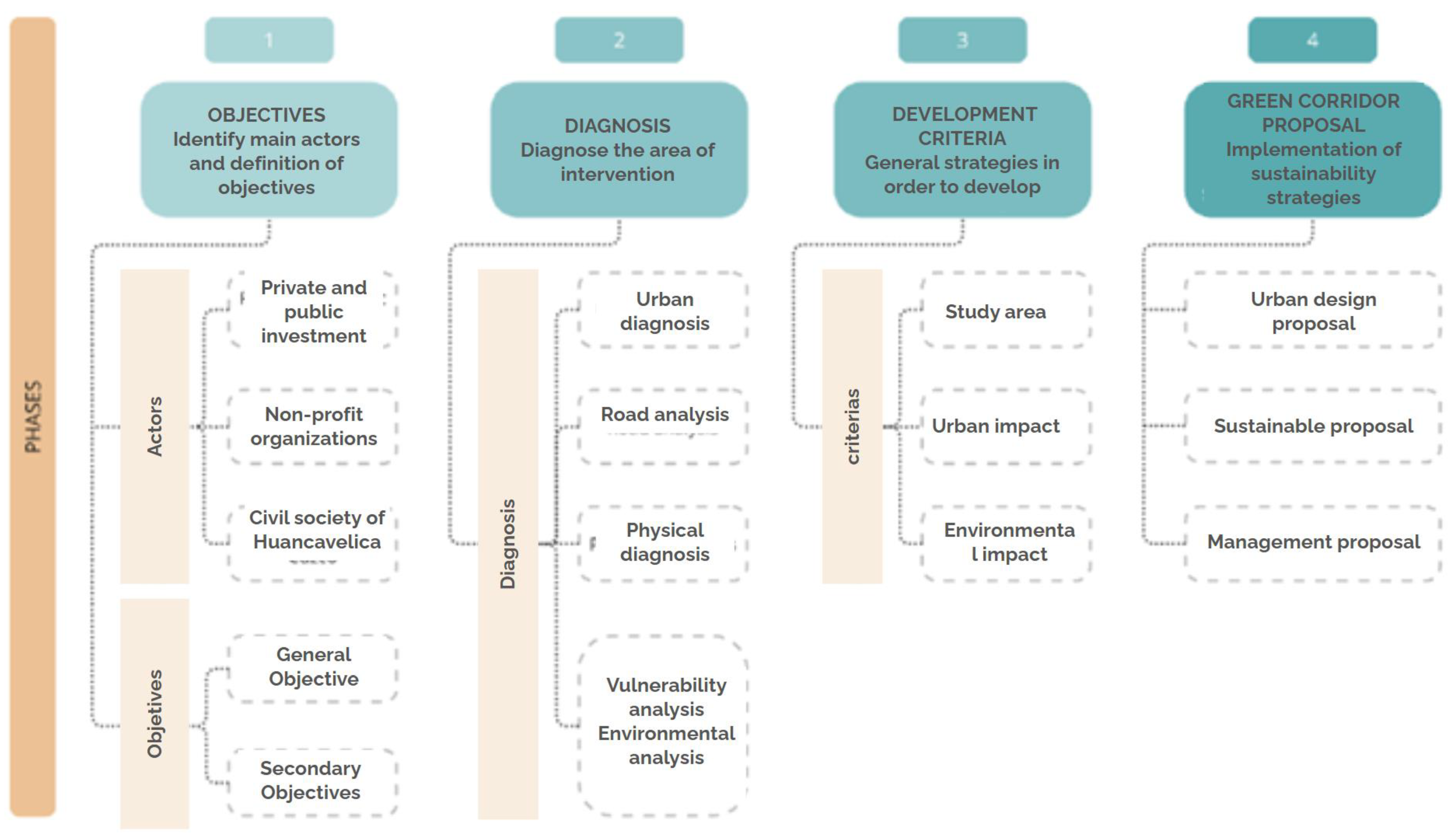
The project formulation was developed from a detailed analysis of both the environment and the intervention area. This methodology enabled the resolution of identified issues and the formulation of clear objectives [37,38]. Figure 2 and Figure 3 shows how an initiative aimed at generating environmental and sociocultural benefits must articulate these dimensions with the needs of the inhabitants and primary users [39]:
  • Determine the main stakeholders and interpret the project’s intentions;
  • Analyze the context and characterize the project site;
  • Design overall guidelines for the structuring of the project;
  • Apply sustainability-oriented approaches.

2.1.1. Recognition of Main Stakeholders and Formulation of Goals

To begin the proposal, it is crucial to initially determine the potential objectives, overall principles, and difficulties that need to be addressed in the implementation of sustainable housing [40]. These approaches will serve as a basis for the initial design scheme and will allow for the identification of key stakeholders whose participation will be essential [41].

2.1.2. Assessment of the Target Area

Once the sustainable housing project has been defined, an assessment of the intervention area is conducted, considering two dimensions: the tangible environment and the cityscape. This allows for the recognition of the elements and interactions present in these areas [42]. The analysis of the built environment aims to identify the relevant characteristics of the natural and ecological components of the area, while the evaluation of the cityscape focuses on understanding the urban attributes of the site, including green public spaces, road infrastructure, pedestrian routes, signage, and existing amenities [43,44].

2.1.3. General Strategies for Developing the Proposal

The project will be organized around two main axes: the urban landscape and the environmental perspective.
  • Public green spaces: Locate and classify the green areas and public spaces present in the city. To this end, planning tools will be used that include cartography and data related to protection and conservation zones, urban parks, and public spaces at different scales (neighborhood, district, metropolitan).
The Figure 4 shows a five-step technical process for developing an architectural project using digital tools: first, information on topography, roads, and population centers is collected using Google Earth; then, the terrain is scaled and drawn in 2D in AutoCAD 2024, taking its topography into account; then, 3D architectural modeling is performed using SketchUp and Revit, incorporating the slope and natural surroundings; finally, a 3D model is used in Sun Path to analyze and verify the solar impact on the facades, ensuring an efficient design adapted to the real context [45,46].

2.1.4. Application of Sustainable Approaches

The implementation of sustainable approaches involves integrating environmentally friendly practices and technologies into projects to minimize negative impacts on natural resources. This includes using renewable energy sources, promoting energy efficiency, reducing waste, and enhancing the ecological compatibility of designs. By applying these methods, projects not only contribute to environmental preservation but also improve the long-term social and economic outcomes, fostering a balance between development and sustainability.

2.2. Location of Place

The research area corresponds to the department of Huancavelica, located in the central region of the country, between latitudes 10°58′ and 14°08′ south and longitudes 74°16′ and 75°47′ west of Greenwich. It is bordered to the north by the department of Junín, to the south by the department of Ica, to the east by the department of Ayacucho, and to the west by the departments of Lima and Ica. The total area covers 2,107,896 hectares. The topography is notably rugged and is formed by the Central Mountain Range, known as the “Cordillera de Chonta”, which constitutes the backbone of the department. The region covers various ecological levels, with altitudes ranging between 1200 and 4500 m above sea level (Figure 5).
The region is composed of 7 provinces: Huancavelica, Acobamba, Angaraes, Castrovirreyna, Churcampa, Huaytara, and Tayacaja. The capital of the region is the city of Huancavelica, which is located at 3600 m above sea level. In the 2017 statistical compendium (CE17), the region had a population of 502,084 people. The Huancavelica region is predominantly rural, which is reflected in the number of rural population centers in the region. The CE17 identified about 119 urban population centers and 6874 rural population centers in the region.
The capital of the Huancavelica district is located at an altitude of 3676 m above sea level, north of the Huamanrazo snow-capped mountain, whose sources give rise to the Ichu River, which flows eastwards. In its natural course, this river crosses the Yauli district and then changes its direction to the north before flowing into the Mantaro River at a later stage. Huancavelica comprises two districts: Huancavelica and Ascensión. It is bordered to the north by the Ascensión district, to the south by the Huachocolpa and Yauli districts, to the west by the Castrovirreyna province, and to the east by the Yauli district.

2.3. Hydrology

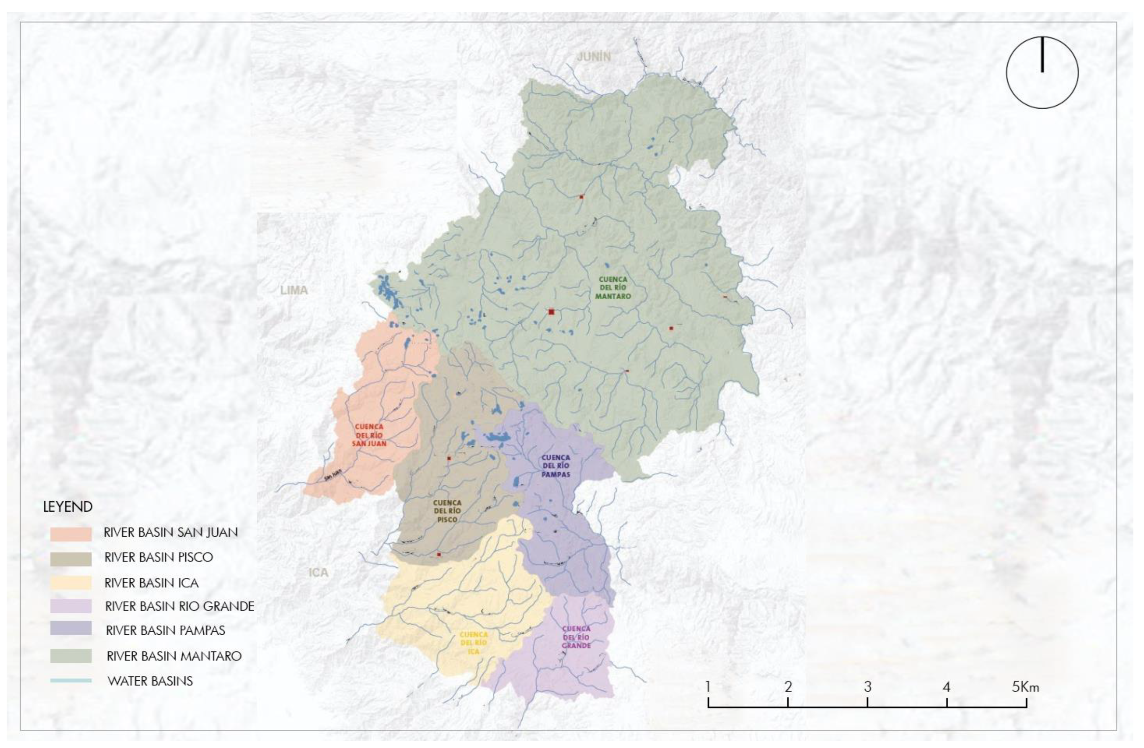
The system of hydrographic basins in the Huancavelica region follows its course along the western and eastern flanks of the Andes mountain range, playing a significant role in shaping the regional physiognomy. It stands out for presenting different geomorphological, climatic, and hydrographic regimes in each of its basins. In particular, the Ichu River basin constitutes a central element in this hydrographic network.
The main watercourse of this basin is the Ichu River, whose initial tributaries are the Astobamba and Cachimayo rivers. Running from north to south, it receives water from the Islacocha lagoon, where it meets the water from the Pumacocha stream. Downstream, the Astobamba River joins the Cachimayo River to form the Ichu River. As it advances, this river initially flows in a northwesterly direction, crossing the Huancavelica district. Along its path, it receives water from the Chumbispampa, Botica, and Machocorral streams, reaching the Callqui estate, where it changes its course to the southeast until it meets the Sacsamarca River. The Ichu River basin not only shapes the hydrography of the region but also plays an essential role in the economic and environmental development of the areas that it passes through, making it vital to understand and properly manage this aquatic system (Figure 6).

2.4. Flora and Fauna

2.4.1. Flora of Huancavelica

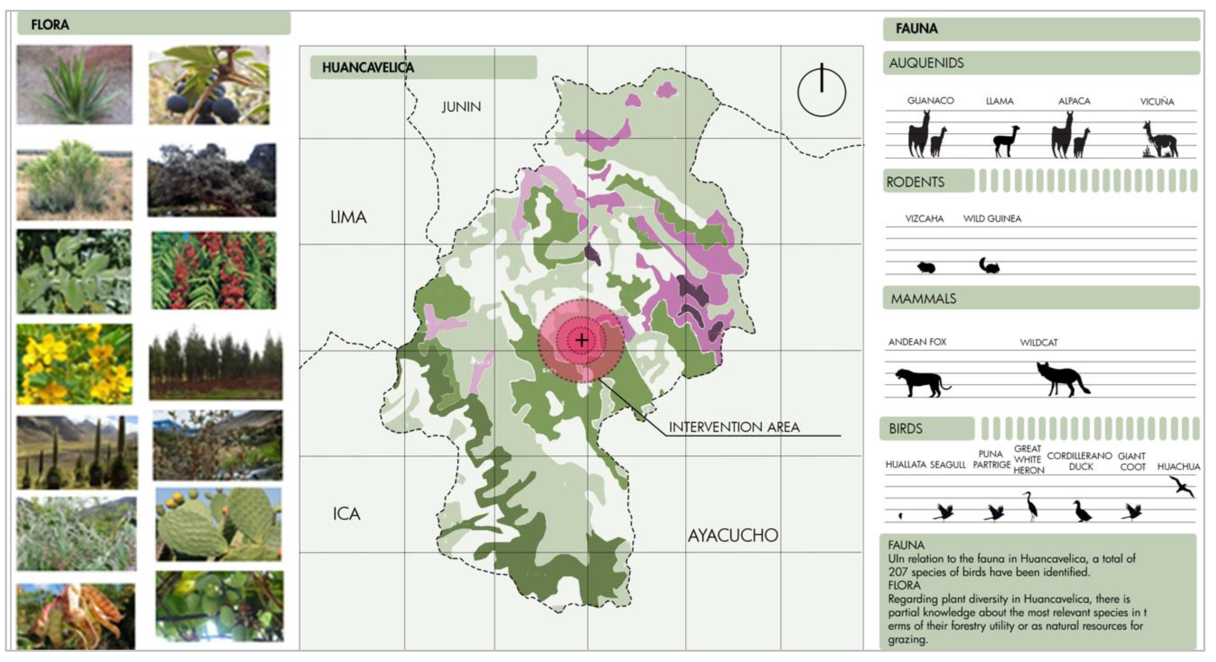
Regarding plant diversity in Huancavelica, there is partial knowledge about the most relevant species in terms of their forestry use or as natural resources for grazing. Although there are some scattered investigations that have allowed the collection of secondary information and the preparation of a preliminary list of flora in the department, there are still gaps in information. These gaps constitute a clear stimulus to encourage more exhaustive research in this field, with the aim of obtaining a more complete and detailed overview of the plant diversity in Huancavelica.

2.4.2. Fauna of Huancavelica

Regarding the fauna in Huancavelica, a total of 207 species of birds have been identified. These birds take advantage of the wetlands and boxwoods present in the region as resting points during their migrations. Some of these species include aquatic birds such as the torrent duck, the Huallata or Andean duck, the Andean duck, the Huachua or Andean goose, the Puna partridge, the pimpollo grebe, the giant coot, the Andean gull, and the great white heron. As for mammals, the groups with the greatest diversity of species are the Chiroptera and rodents, among which are the vizcacha and the wild guinea pig. In addition, larger mammals, such as the puma, the Andean fox, the wild cat, and the four species of South American camelids, stand out: alpaca, guanaco, llama, and vicuña. These data come from studies carried out in Huancavelica (Figure 7).

2.5. Climatology

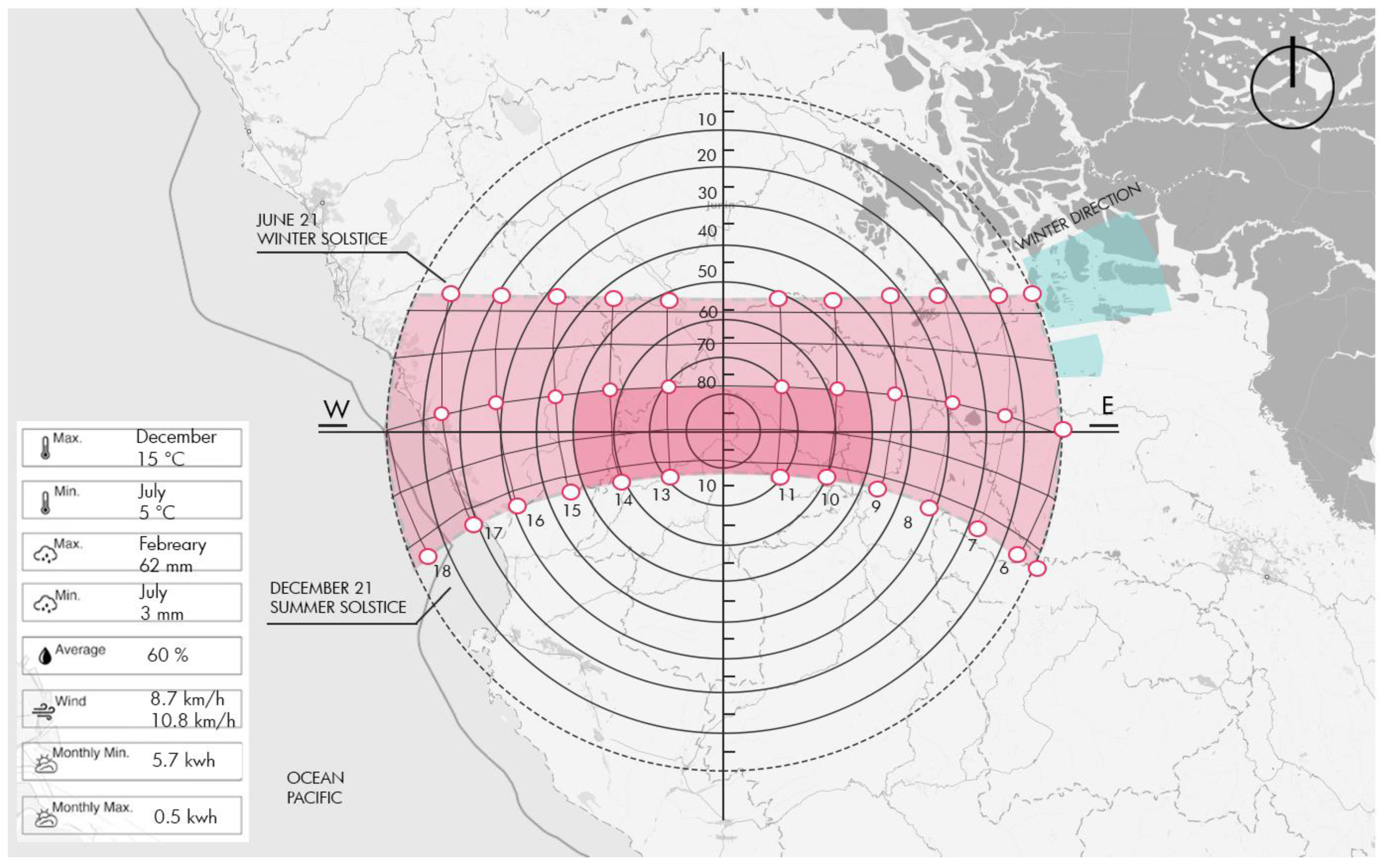
The climate in Huancavelica experiences fluctuations, ranging from temperate to cold environments, reaching extreme cold in the areas of the Puna. Despite these conditions, the four natural regions present in the region (Quechua, Suni, Puna, and Janca) allow for the diversity of botanical species and the existence of human settlements. These settlements, although of low or medium population density, are adapted to carry out specific agricultural activities. Altitude variations also generate diverse microclimates: on the western slope, the climate ranges from arid to subhumid, depending on the altitude, with rainfall ranging from 70 mm near the coast to up to 800 mm at altitudes beyond 4800 m above sea level (Figure 8).

2.5.1. Climate Analysis, Temperature, Winds, Precipitation, and Solar Radiation

The warm season lasts approximately two months, from 8 October to 9 December, during which time the average daily high temperature exceeds 16 °C (60 °F). November is the warmest month of the year, with an average high of 16 °C (60 °F) and a low of 5 °C (41 °F). In contrast, the cool season lasts approximately 1.6 months, from June 9 to July 27, and is characterized by average daily highs below 15 °C (59 °F).
The rainy season lasts approximately 6.9 months, from September 20 to April 18, with a rolling average of 31 days, with rainfall equal to or greater than 13 mm (0.5 inches). February is the month with the highest rainfall accumulation, recording an average of 62 mm (2.4 inches). On the other hand, the dry season lasts approximately 5.1 months, from April 18 to September 20. July stands out as the month with the least rainfall, with an average of just 3 mm (0.1 inches).
The average hourly wind speed varies slightly seasonally throughout the year. The peak wind period extends for approximately 4.1 months, from July 13 to November 17, with average speeds exceeding 9.8 km per hour. August stands out as the windiest month of the year, recording winds at an average speed of 10.8 km per hour. In contrast, the calmest period of the year spans 7.9 months, from November 17 to July 13. May is the mildest month, with winds at an average speed of 8.7 km per hour.
This section examines the total amount of shortwave solar energy reaching the Earth’s surface daily over a large area. It considers seasonal fluctuations throughout the day, the height of the sun above the horizon, and absorption by clouds and other atmospheric elements. Shortwave radiation includes both visible light and ultraviolet radiation. The average amount of solar energy received per square meter per day remains fairly constant throughout the year, ranging from approximately 0.5 to 5.7 kilowatt-hours.

2.5.2. Givoni Climate Diagram

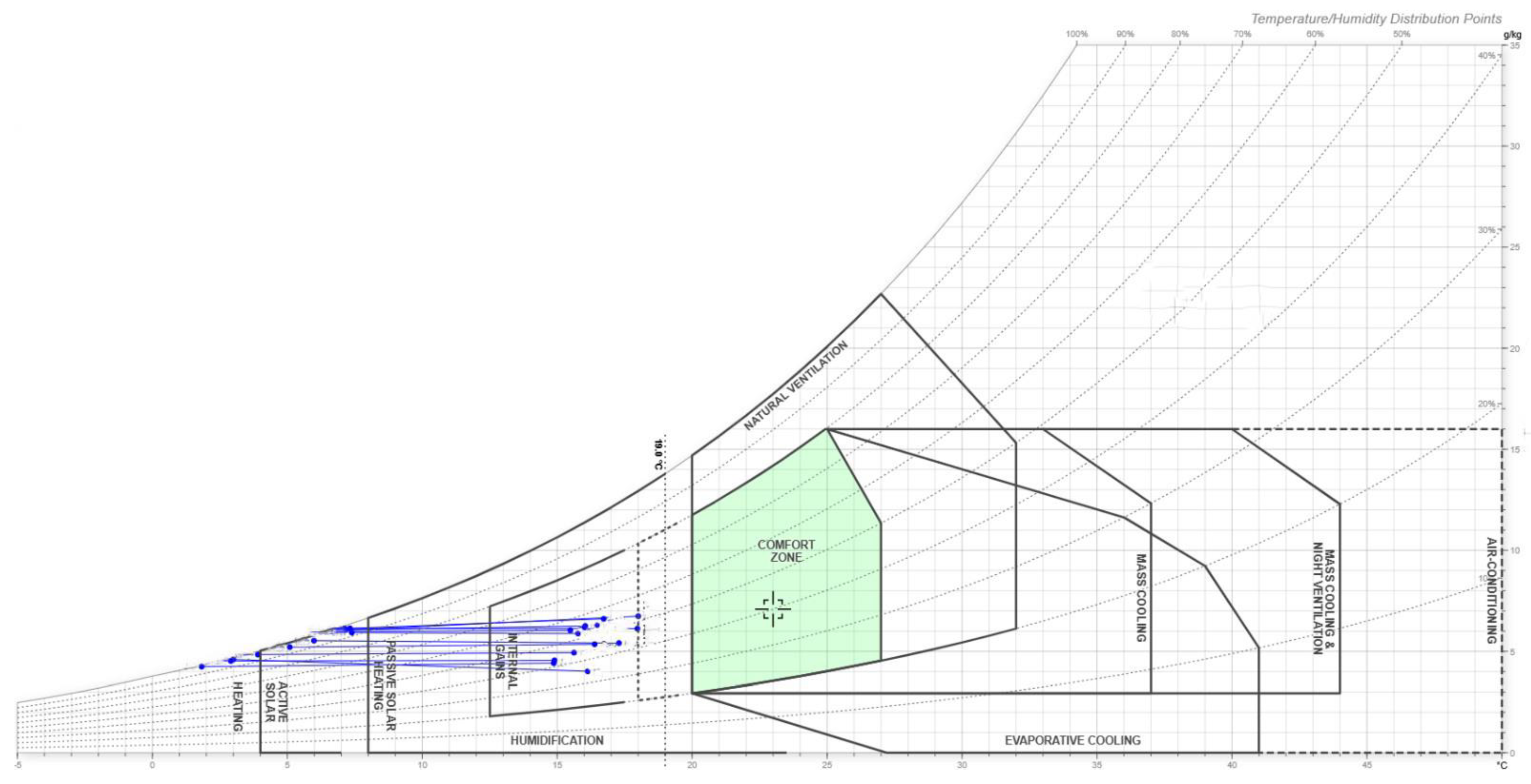
In the Givoni bioclimatic diagram, several zones are delimited, whose temperature and humidity characteristics indicate the convenience of using certain design strategies in the building. In the case of the study area, the determined zones are of permissible comfort and capacity for internal gains. The strategies that can be implemented include an efficient natural ventilation system, which would be able to mitigate high temperatures, while also addressing high humidity. As well as the heating strategy by internal gains (heat generated by equipment, occupation, activity, and clothing of people), it is not considered necessary to adopt strategies in the design of buildings (Figure 9).

3. Results

3.1. Project Location

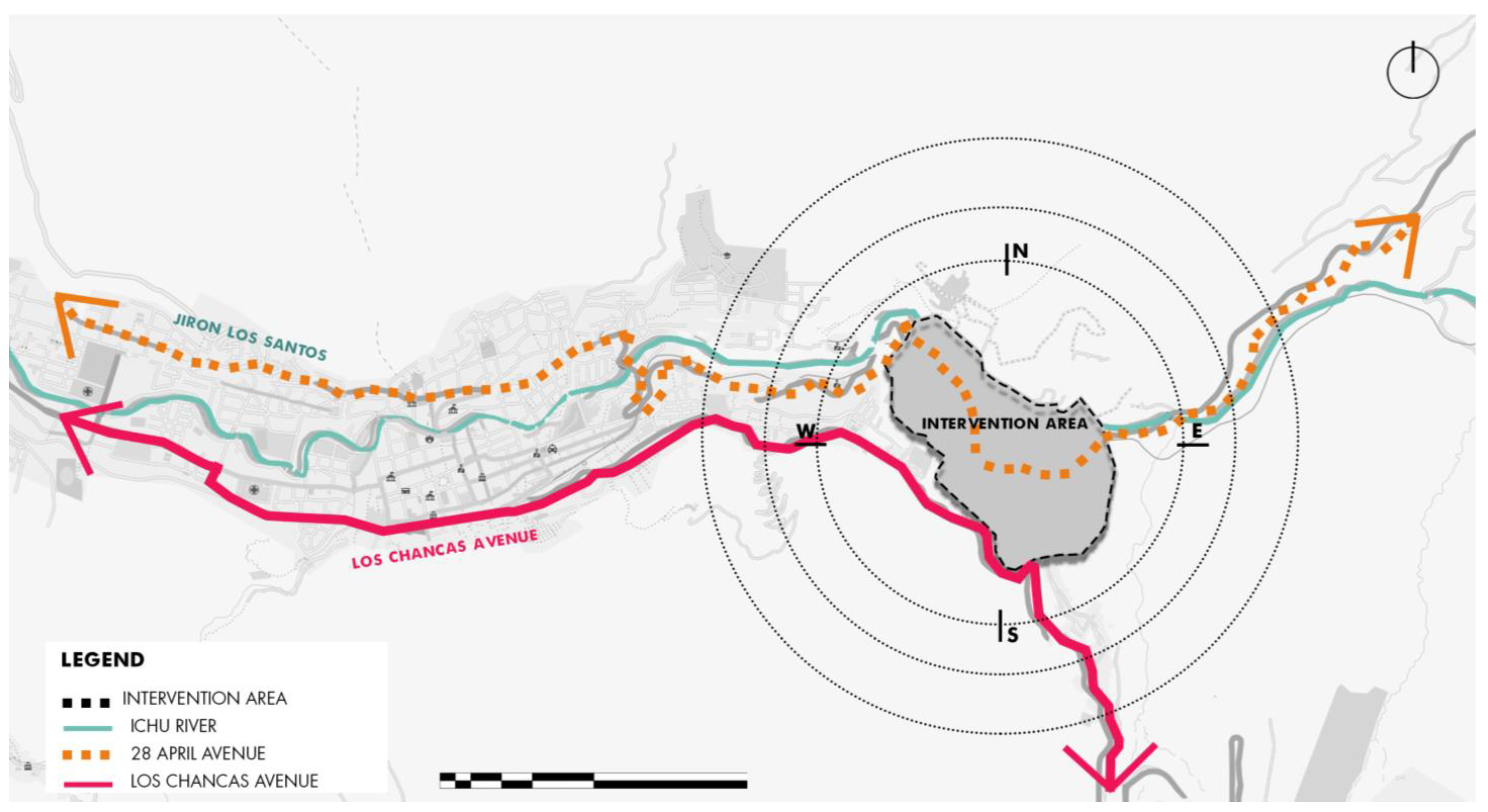
The intervention area is located at the coordinates 12°47′01″ south latitude and 74°58′07″ west longitudes, at an altitude of 3670 m above sea level. This strategic point will allow the creation of a series of public spaces on the banks of the Ichu River, promoting the revaluation and ecological restoration of the area. The intervention will not only improve the water quality of the Ichu River through urban landscape regeneration and wastewater management strategies but will also raise the quality of life of local residents by providing recreational and leisure areas. In addition, the implementation of pedestrian paths, viewing points, and green areas will promote sustainable tourism, contributing to the economic development of the region (Figure 10).
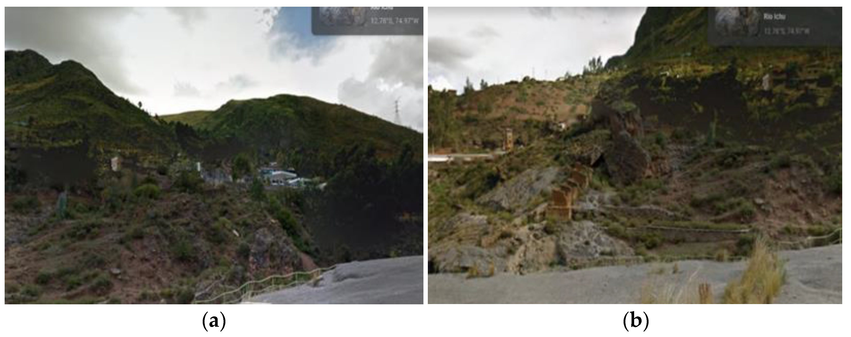
The land was chosen because it is located at a strategic point in the city of Huancavelica, and it is also close to the main river for the town, which is the Ichu River. The land will have multiple entrances since it will be an open space, which will allow value to be given to the public space and boost commerce in the area. The Ichu River, as a very important source of water, plays a fundamental role in the choice of the land, due to the excellent visual and natural thermoregulatory effects, which will also allow the provision of landscape value in the proposal of public spaces (Figure 11).

3.2. General Planimetry in the Implementation of Regeneration Strategies

The recovery of public spaces will take place in three phases, which will be differentiated into three approaches: physical aspects, biophysical aspects, and social aspects.
Table 1 shows the strategies for urban landscape regeneration, which will allow the revaluation of the riverbanks of the Ichu River and the recovery of public spaces. Each of these phases will be essential to guarantee the comprehensive and sustainable recovery of public spaces, improving both the natural environment and the lives of the inhabitants.
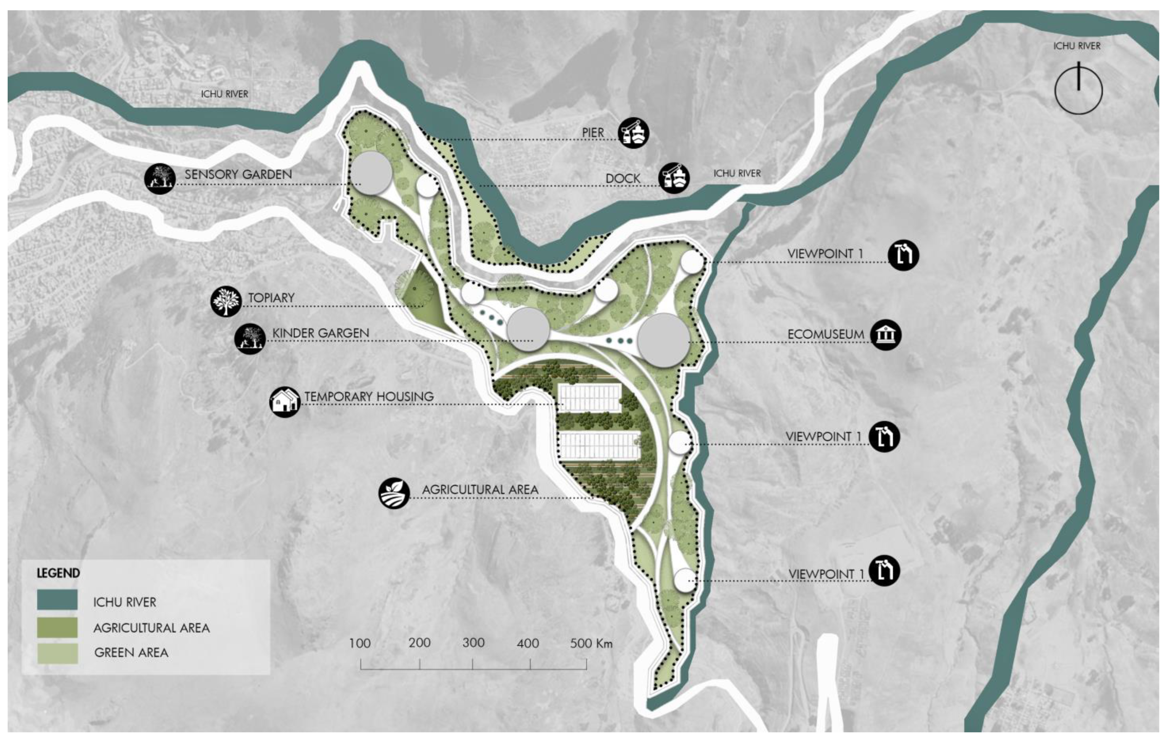
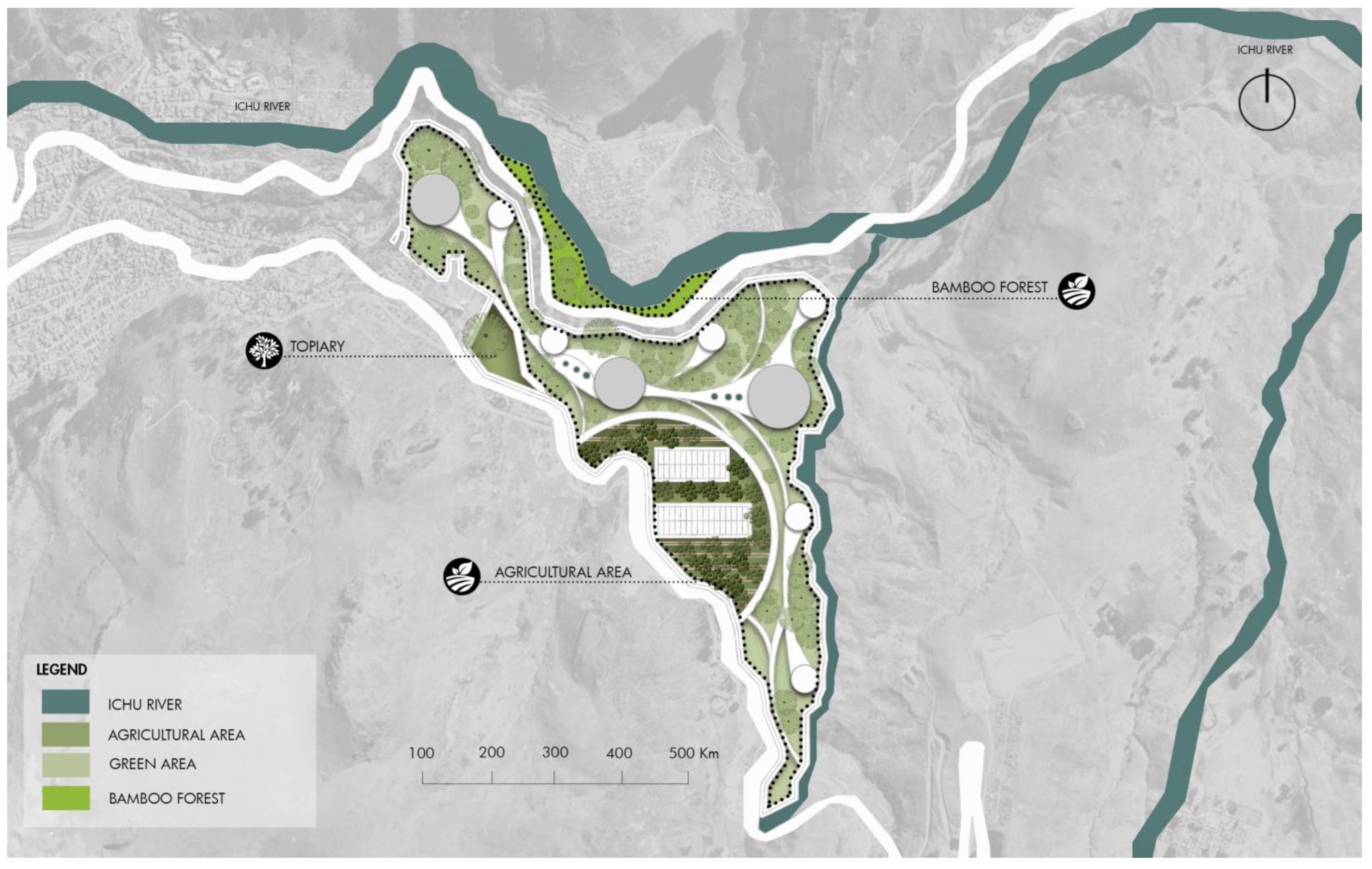
The proposal includes spaces such as topariums, sensory gardens, children’s gardens, a greenhouse, docks, seawalls, temporary housing, and ecomuseums. The proposal is a comprehensive vision that embraces the richness and diversity of spaces intended for human connection with nature and culture. Planning includes the installation of sustainable drainage systems and the use of native vegetation to stabilize the banks and prevent erosion. These measures, combined with environmental education programs for the community, will ensure the long-term sustainability and success of the project.
Among these, the topariums stand out, designed to dazzle with their shapes and colors, offering visitors a unique visual journey. Sensory gardens are presented as oases for the senses, inviting visitors to explore and experiment with textures, fragrances, and sounds that highlight the beauty of nature. In addition, the proposal includes the creation of children’s gardens—spaces designed to encourage creative play and early connection with the natural environment. A greenhouse becomes the green heart of the proposal, serving as a space for experimentation and education about the local flora. Piers and jetties offer meeting points by the water, enriching the experience by providing panoramic views and serene places for reflection. In addition, temporary housing is incorporated that allows visitors to fully immerse themselves in the experience of the place, as well as ecomuseums that narrate the history and ecology of the environment (Figure 11).
In line with Jane Jacobs’ superblock theories, an ingenious design is established that integrates the river as a form of natural access to public spaces and pedestrian paths that meander between homes. This proposal seeks to take advantage of the presence of the river not only as a scenic and refreshing element but also as a means of connection between residents and common spaces. By interweaving pedestrian paths with the natural fluidity of the river, an environment is created that encourages community interaction and sustainable mobility, embracing the philosophy of superblocks to promote harmonious coexistence between architecture, nature, and community life (Figure 12).
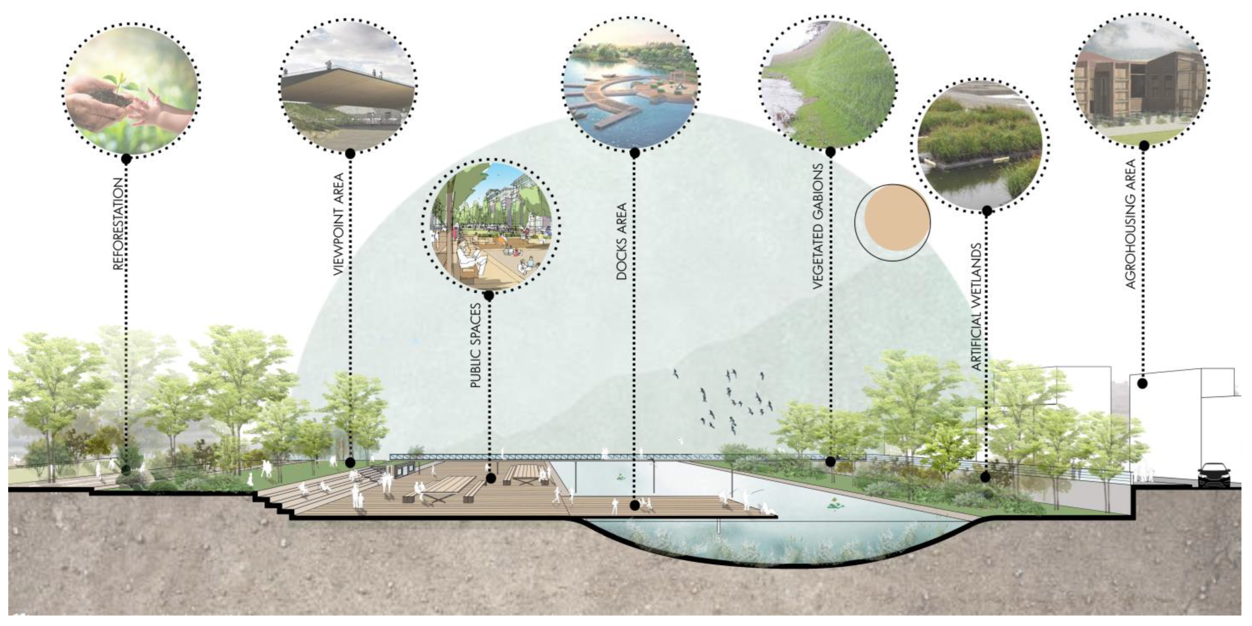
Figure 13 shows a cross-section of the proposed green infrastructure along the Ichu riverbank. First, it highlights the riparian reforestation strip, where native tree and shrub species are planted in staggered rows following the contour lines of the slope. These plantings are prepared with 30 × 30 × 30 cm holes, enriched with organic amendments to ensure the initial growth of the seedlings.
Below the reforestation, the slope has been stabilized using bioengineering techniques that combine a biodegradable geotextile with plantings of creeping species and fast-rooting grasses. The slope is designed with a moderate gradient to reduce the velocity of runoff flows [47]. At the base of the slope, a gabion riprap filled with local stone is installed, acting as a temporary retaining wall and energy dissipator during flood events, protecting the upper vegetation strip while the roots establish [48]. Additionally, the high basin or retention basin can be seen, excavated within the riverbed in an oval shape with a variable depth (0.50–1.00 m at the lowest point). This space acts as a buffer during periods of intense rainfall, retaining excess flow and reducing downstream pressure. The bottom of the basin is lined with a layer of 20–40 mm gravel to improve infiltration and prevent excessive sedimentation, while, along the edges, geotextile bags planted with hydrophyte species (Typha latifolia or Scirpus spp.) are installed to function as biological filters.
Finally, in the transition to the public roadway, a buffer and urban reforestation zone is designed, consisting of planted beds with shade tree species (Polylepis spp., Buddleja montana) and ornamental shrubs (Escallonia resinosa) established on a substrate of at least 30 cm of enriched topsoil. A 2.5-m-wide permeable pedestrian path composed of concrete pavers connects the green area to the road network, while urban furniture such as wooden benches and pergolas with native climbing plants provides comfort and encourages the social appropriation of the space. LED luminaires with dusk sensors and interpretive signage complete the amenities, ensuring nighttime safety and facilitating educational outreach about the project’s ecology [49].

3.3. Physical Scope

3.3.1. Pier and Boardwalk

There is a need to establish a dedicated riverside area adjacent to the proposed site to improve accessibility for visitors. This strategic area, which will include a dock and a disabled-friendly path, will provide convenient access from the river to the proposal. Durable and sustainable materials, such as treated wood and eco-friendly composites, will be used for the construction of these infrastructures.
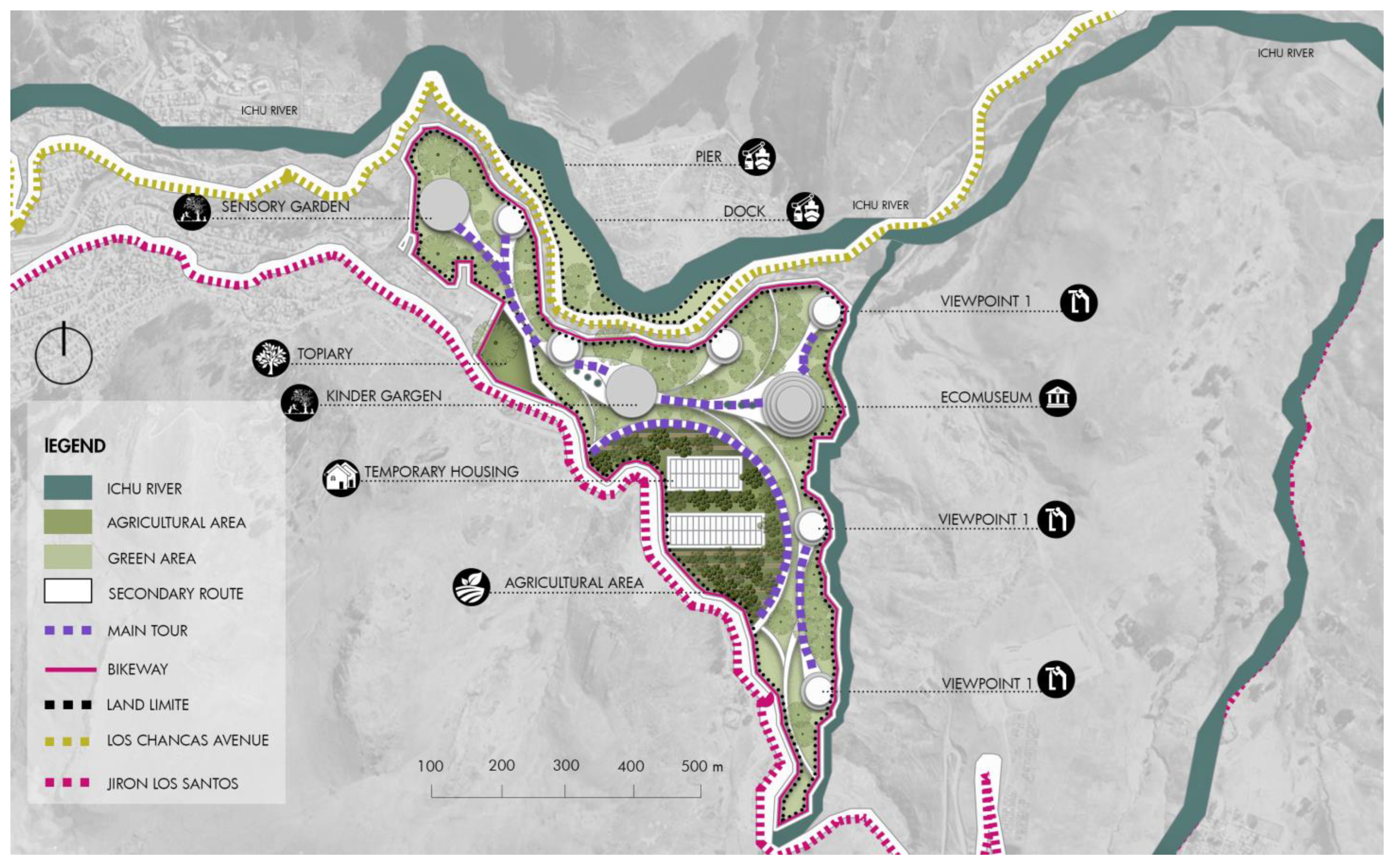
The circular pathway shown on the plan is a key element within the territorial design, as it not only links the various functional zones of the project (such as gardens, agricultural areas, and temporary housing zones) but also serves as an ecological corridor that promotes environmental connectivity, landscape conservation, and community well-being (see Figure 14).
This pathway integrates primary and secondary routes, a bike lane, and viewpoints, enabling a fluid and sustainable interaction between people and the natural environment. The layout of the circuit adapts to the site’s topographic conditions, respecting natural watercourses and enhancing native vegetation. The inclusion of green spaces and agricultural areas within the alignment creates microhabitats, which support local biodiversity and strengthen the ecological functionality of the corridor.
The inclusion of native vegetation in the surrounding areas will not only improve the visual appeal of the access but will also contribute to local biodiversity and the stability of the river banks. The planning of this area has been carried out considering environmental and river impact studies, ensuring that the aquatic ecosystem and the dynamics of the river are not negatively affected.
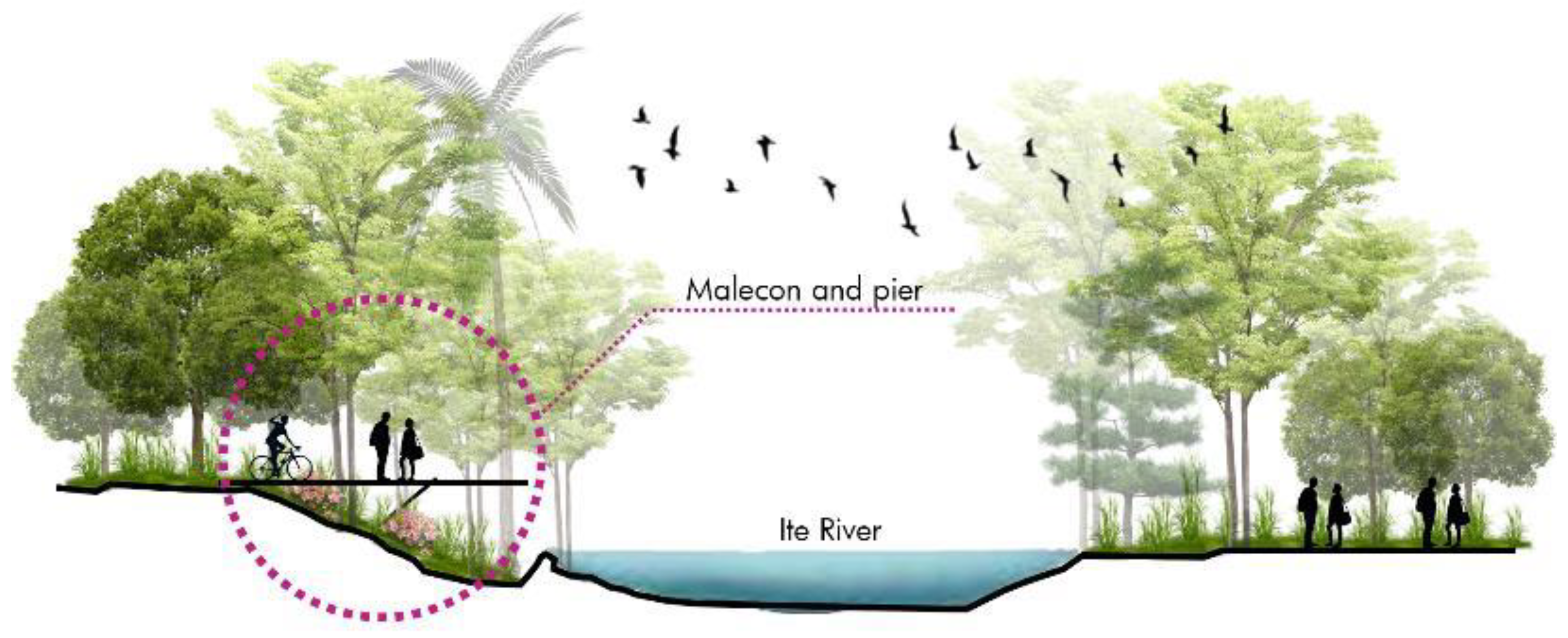
Figure 15 presents the detailed layout of the route along the quay, which includes a cycle path and designated rest areas. This design considers the integration of ergonomic street furniture and shaded areas for greater user comfort. The layouts of the cycle path and bicycle parking facilities are designed with accessibility and sustainability criteria in mind. The bicycle parking stations are equipped with solar chargers, which allow cyclists to recharge their electronic devices in an environmentally friendly way. The materials used in the construction of the cycle path, such as permeable pavement, not only reduce the environmental impact but also improve rainwater management. The precise locations of the cycle path and bicycle parking facilities are also specified, highlighting the incorporation of solar technology in the chargers. This approach not only encourages the use of sustainable means of transport but also promotes the self-generation of clean energy. The route design encompasses the quay, the cycle path, and the designated rest areas, ensuring a comfortable and safe experience for all users. The planning of these infrastructures has been carried out with a comprehensive approach, considering both functionality and environmental sustainability.

3.3.2. Activities

  • Sightseeing tour
The aim is to boost tourism activity in the degraded area, which is why the creation of a tour designed to raise awareness among visitors about the relevance of the environment and about the environmental problems existing in Huancavelica is proposed. This tourist circuit seeks to provide users with an educational and awareness-raising experience, highlighting the importance of environmental conservation and addressing the specific problems that affect this region. The focus of the tour is to actively involve visitors, providing detailed information about the local biodiversity, environmental challenges, and ongoing preservation initiatives. In addition, it is intended to raise awareness about the fragility of the ecosystems in this region and the importance of active participation by the community and visitors in preserving this unique environment. This initiative seeks to provide detailed information about each space, thus facilitating the understanding and appreciation of the specific functions of each sector within the project.
  • Boat trip
Without exception for the river adjacent to the study area, it is proposed to use a means of transportation that is valid for the area, such as boats, to reach the destination from any nearby area.
  • Organic structure
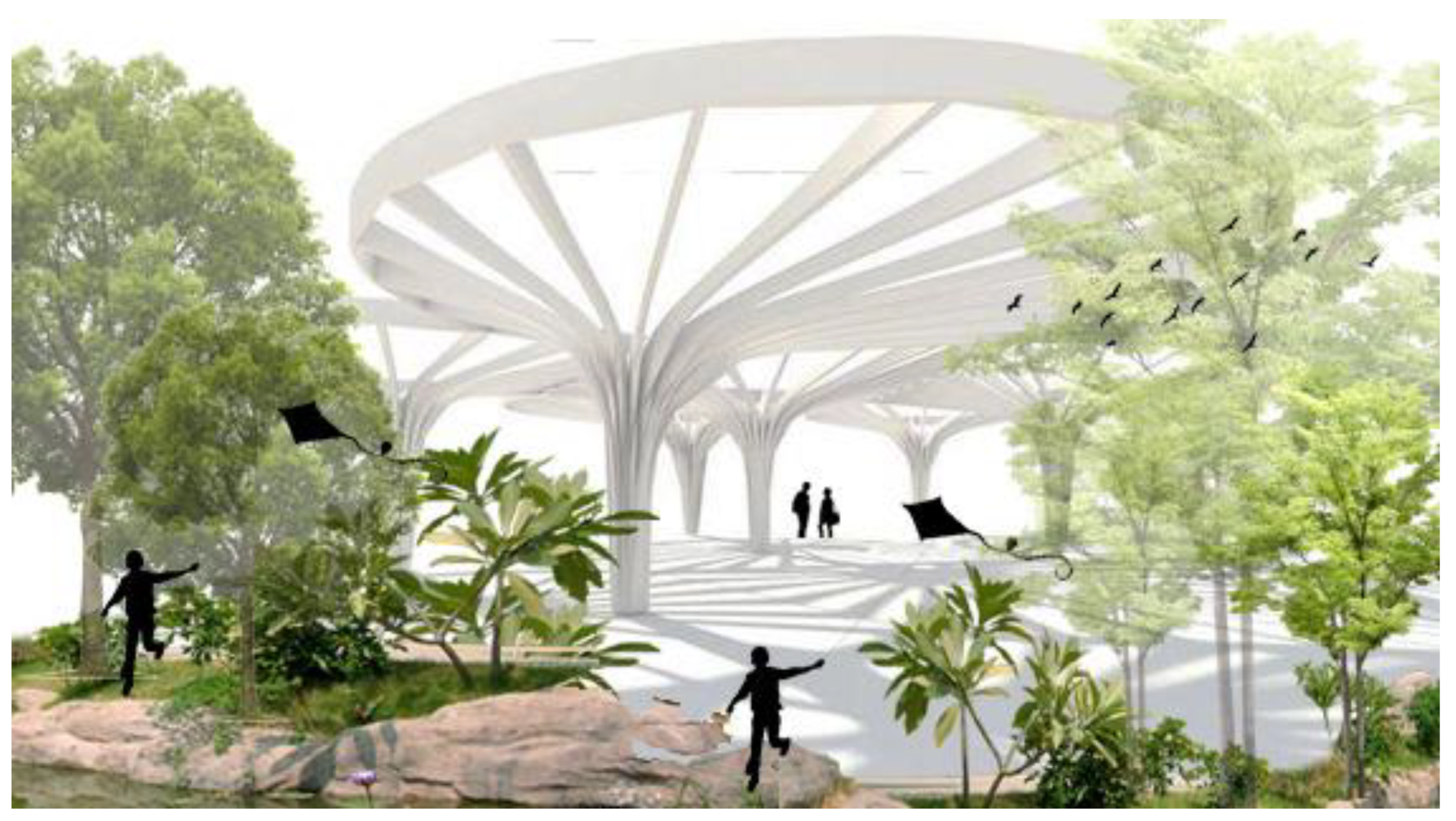
This is a model created from algorithms inspired by the nature of Huancavelica, where the superimposed geometries become structural columns or “trunks”. Pergolas are distributed throughout the ecomuseum complex to provide shade and places to rest.
This design is based on parametric algorithms inspired by the natural morphology of Huancavelica, where overlapping geometric patterns generated using L-systems and computational geometry techniques define the trunk-shaped structural pergolas. Each conical column, modeled from local topological data and plant morphologies, is optimized to withstand gravitational and wind loads through finite element analysis. These columns use a galvanized tubular steel alloy coated with protective varnish and laminated native wood, ensuring stiffness, durability, and esthetic integration with the Andean landscape.
Functionally, the spatial distribution of the pergolas follows a topological optimization algorithm that maximizes shading coverage (60–70% at midday) and facilitates pedestrian flow. Their profiles, derived from parameterized curves, ensure a minimum slope (5–7%) for rainwater runoff toward hidden gutters. Thus, these structures not only serve as esthetic elements referencing local vernacular architecture but also function as passive environmental control systems: they reduce direct solar radiation, buffer winds, and channel water toward underground collection systems, creating comfortable microclimates for visitors and reinforcing the ecomuseum’s sustainability (Figure 16).

3.4. Biophysical Scope

The implementation of the landscaped green area within the green corridor is presented as a comprehensive proposal within the biophysical field, focused on improving both environmental quality and local biodiversity. This green space is designed to maximize CO2 absorption and oxygen production, contributing significantly to climate change mitigation. Using a variety of native and locally adapted plant species, greater resilience and adaptation to the local climate conditions is ensured. The design of the landscaped area includes the implementation of efficient irrigation systems, such as drip irrigation, which allow for the rational use of water and significantly reduce waste. Sustainable gardening practices, such as composting and the application of organic fertilizers, are also incorporated, which improve the soil and stimulate healthy vegetation development.
A detailed analysis of the environmental impact and CO2 absorption capacity has been carried out using conversion factors provided by the World Health Organization (WHO). This analysis shows that the green area effectively contributes to improving the air quality, providing a healthier environment for residents and visitors. The proposal also includes the creation of habitats for local fauna, such as birds and pollinators, by installing shelters and planting specific floral species. This not only enriches the biodiversity but also promotes pollination and ecological balance.
Figure 17 shows that the integration of the landscaped green area within the ecological corridor generates consistent results in carbon dioxide absorption and clean air production. These results were obtained by applying conversion factors established by the World Health Organization (WHO).
  • a = 2.3 kg (b) per year, where
  • a represents the amount of CO2 captured annually (kilograms per year);
  • b corresponds to the area of green area analyzed (landscaping), expressed in hectares;
  • c = 1.7 kg (b) per year, where
  • c indicates the amount of clean air generated each year (kilograms per year);
  • b refers to the size of the landscaped green area evaluated, in hectares.
Table 2 shows the amount of carbon dioxide absorbed by the landscaped green area incorporated into the ecological corridor, reaching a total of 21.16 kg. As a result of this capture, approximately 3.4 kg of clean air is generated.
Table 3 presents a specific urban landscape regeneration strategy based on the implementation of a green bamboo forest. It indicates that an area of 1.8 hectares (ha2) has been planted with bamboo plantations, and, as a result, this surface is capable of absorbing approximately 38.53 tons of carbon dioxide (CO2).

3.5. Social Scope

The implementation of an ecomuseum, temporary housing, a sensory garden, and a children’s garden is presented as a comprehensive proposal within the social sphere, designed to foster environmental education, community cohesion, and the well-being of residents and visitors. The ecomuseum will serve as an interactive educational center that will highlight the natural and cultural history of the region, promoting environmental awareness and sustainability through participatory exhibits and activities. Together, these facilities will not only improve the quality of life of the community but will also promote a sense of belonging and environmental responsibility. The planning and execution of this project will be based on principles of community participation, ensuring that the needs and desires of local residents are reflected in the final design.

3.5.1. Ecomuseum

This is an area where the cultural heritage of the town can be interpreted and valued for sustainable development. The ecomuseum would be located in an area of 2500 square meters, where a pedestrian and vehicular route is planned for cultural and social exchange. This space is meticulously conceived to accommodate both a pedestrian and vehicular route, shaping an environment that favors dynamic exchange between visitors. The strategic layout of the museum harmoniously links with public spaces, creating a tangible bridge between the cultural heritage and the surrounding community.
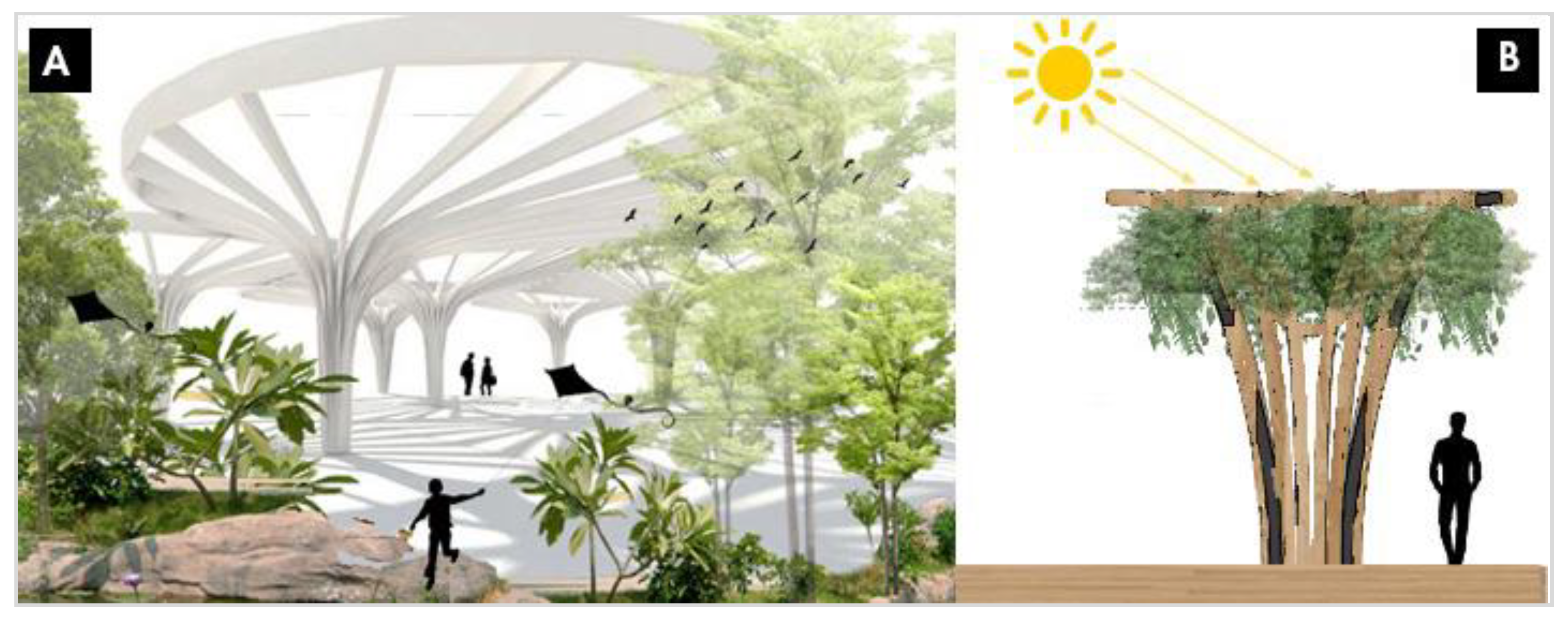
Figure 18A illustrates a central tree within the ecomuseum’s internal circulation, acting as a bioclimatic regulator by modulating both natural lighting and solar radiation. The tree’s canopy is positioned to dynamically cast shade over key pathways and gathering areas, thereby reducing the solar heat gain on adjacent surfaces. By intercepting direct radiation, the canopy lowers surface temperatures and limits convective heat transfer to the surrounding space, contributing to occupants’ thermal comfort. Additionally, the tree’s transpiration process facilitates evaporative cooling, further reducing the local air temperature during periods of high insolation.
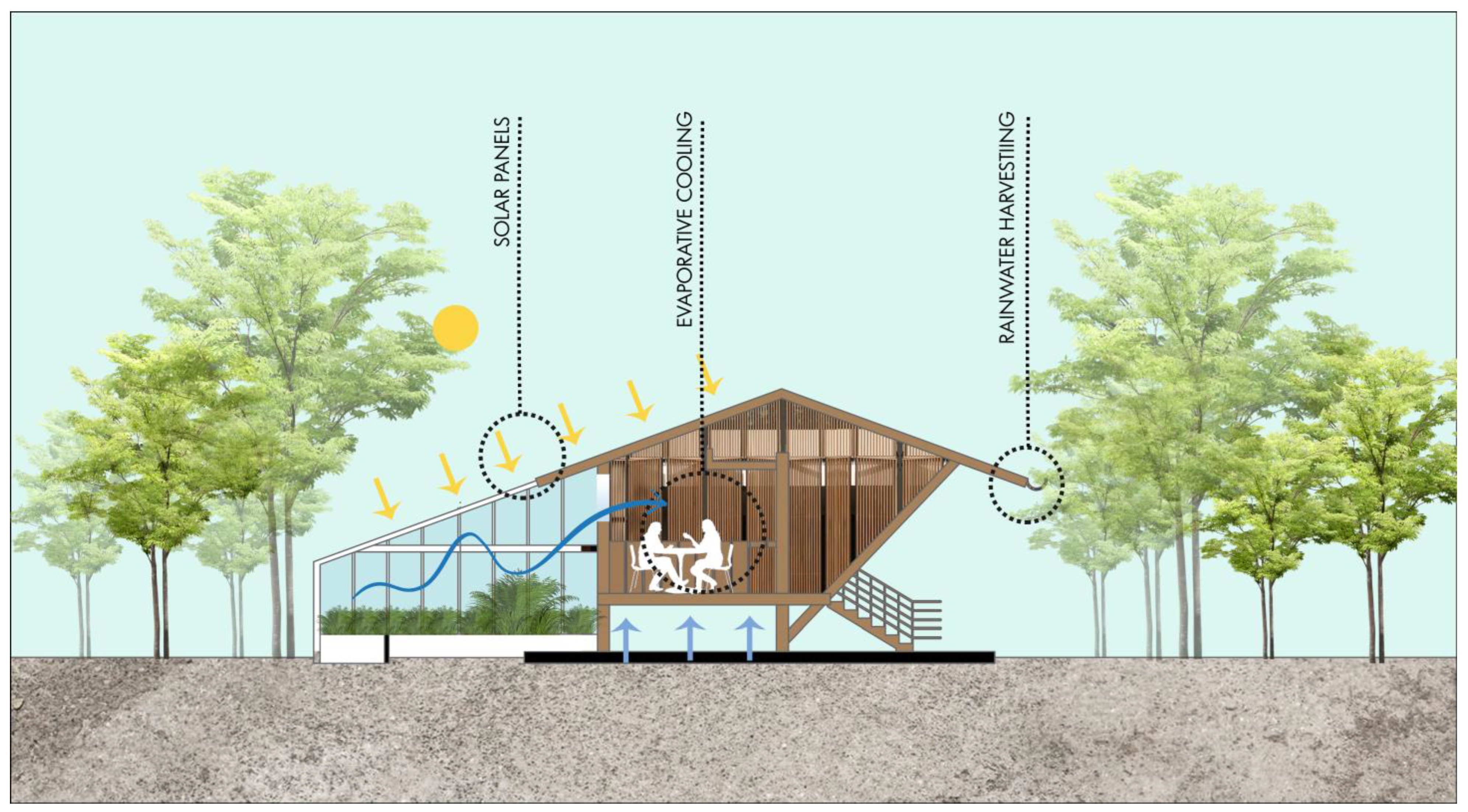
Figure 18B depicts the passive ventilation system integrated into the museum’s envelope. Fresh air enters through strategically placed low-level inlets on the lateral façades, where it passes over thermal mass elements and vegetated surfaces that precondition the airflow. As the air warms, it rises and is expelled through operable louvers located at the crown of the structure, exploiting the stack effect to maintain the continuous exchange of air. Photovoltaic panels installed on the roof also function as semi-transparent shading devices, capturing solar energy while diffusing daylight into the interior. This combined approach of natural ventilation and solar harvesting achieves a comfortable indoor microclimate maintaining operative temperatures within ASHRAE’s defined comfort range (approximately 22–26 °C under local climatic conditions) without relying on mechanical cooling systems. Thus, the ecomuseum’s design exemplifies an inclusive, accessible structure that not only enhances the visitor experience through passive environmental controls but also fosters a cultural and social dialog by integrating thermal comfort strategies with community-oriented spatial programming.

3.5.2. Temporary Residence

The temporary housing is designed to provide short-term accommodation for visitors and volunteers, integrating sustainable design principles. These homes will be built with local materials and bioclimatic techniques to reduce the environmental impact and increase their energy efficiency. In addition, rainwater harvesting and solar energy systems will be implemented to ensure the self-sufficiency of these structures. This is an area intended for visitors, tourists, and researchers who require long stays in the study area.
Figure 19 shows the temporary residential buildings, which have been designed with elevation from the ground in order to ensure optimal internal ventilation in each unit. In addition, these temporary dwellings are equipped with roofs made of palm leaves, designed to prevent the direct penetration of sunlight. This architectural approach seeks to establish a habitable environment that effectively combines functionality and sustainability, offering temporary occupants comfortable living conditions.
The proposed greenhouse was designed for species that require special attention. This offers several benefits, such as early fruit development, enabling off-season production and savings in water and fertilizer consumption and facilitating insect and pest management. Also noteworthy is the greenhouse’s induced natural ventilation system, designed with a strategic vent in the roof to maximize air circulation.

3.5.3. Sensory Garden and Kindergarten

The sensory garden emerges as a space designed to enrich the experiences of those visiting the ecomuseum, providing them with the opportunity to immerse themselves in and enjoy the lush vegetation of the surroundings (Figure 20).
This special corner seeks to stimulate the senses, allowing visitors to connect in a unique way with the surrounding nature through meaningful sensory experiences. The sensory garden is designed to be inclusive and accessible, offering a multi-sensory experience that stimulates the senses through the diversity of aromatic plants, varied textures, and natural sounds. This space not only provides a place of relaxation and therapy for people of all ages but also serves as an educational tool to teach about biodiversity and the care of green spaces.
The children’s play area, integrated into the proposal, is designed to meet the recreational and skills development needs of children from the local community and visitors. This space is conceived as an enabling environment that promotes safe recreation and skills development through interaction and free play. The installation of this area is based on the creation of a safe and open environment, conducive to interaction and play between children. The kindergarten, meanwhile, will focus on the play and educational development of children, incorporating interactive and safe play elements that encourage outdoor learning and connection with nature. Eco-friendly and safe materials will be used in the construction of the playgrounds, and cultivation areas will be integrated where children can learn about gardening and the importance of sustainable agriculture.
  • Implementation of local materials
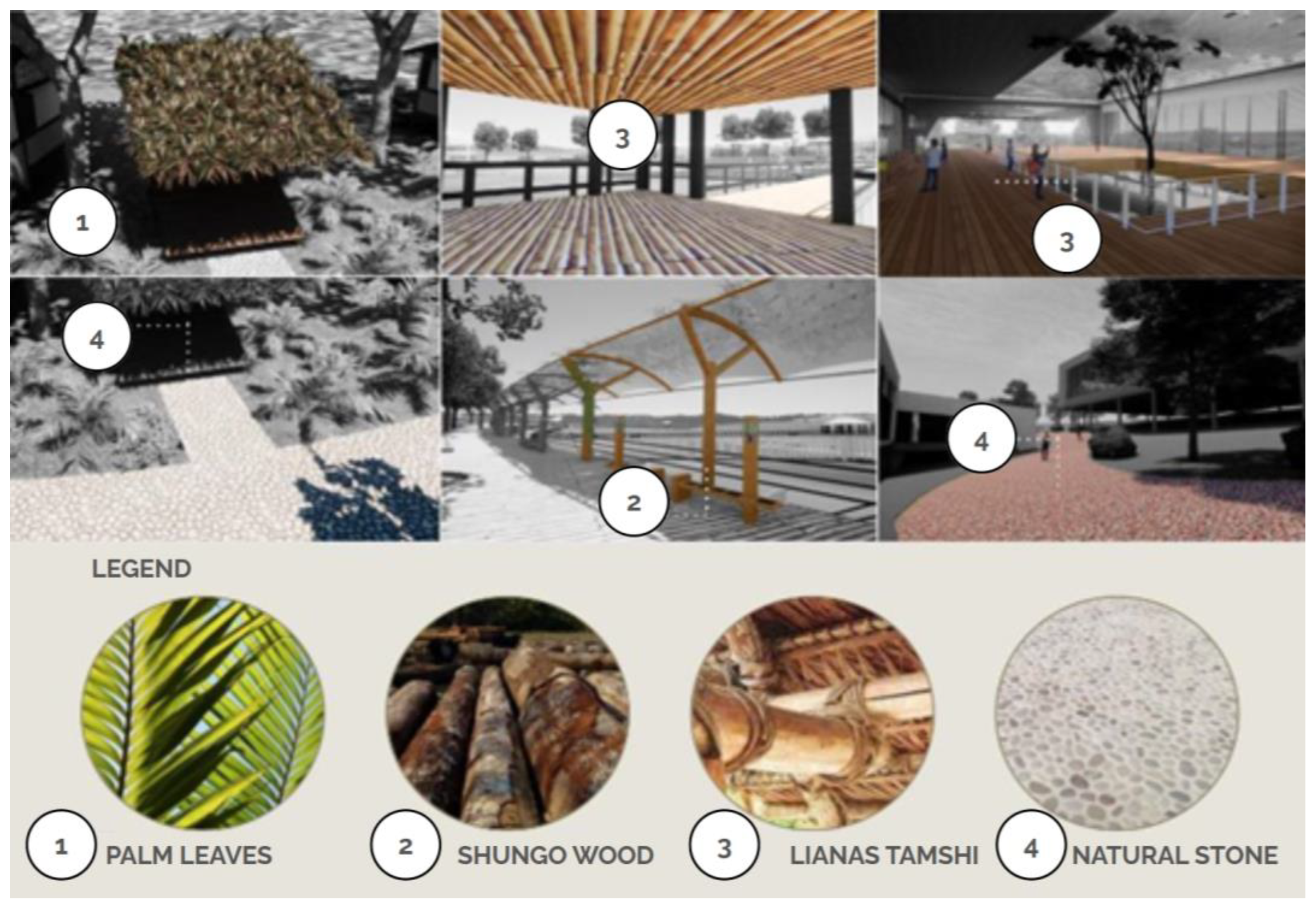
The implementation of specific materials such as palm leaves, shungo wood, tamshi vines, and natural stone in a sustainable proposal is essential to ensure harmony with the environment and reduce environmental impacts. Palm leaves, with their renewable nature, can be used in roofs to provide shade and control temperatures. Shungo wood, from sustainable sources, can be used in the structures of buildings, providing strength and durability. Tamshi vines, with their flexibility, are ideal for the creation of decorative and structural elements. Finally, natural stone, extracted in a sustainable manner, can be used in cladding and paving, adding esthetic appeal and being long-lasting (Figure 21).

3.6. Strategies Applied to the Project—Types of Clean Technologies

3.6.1. Wind Energy

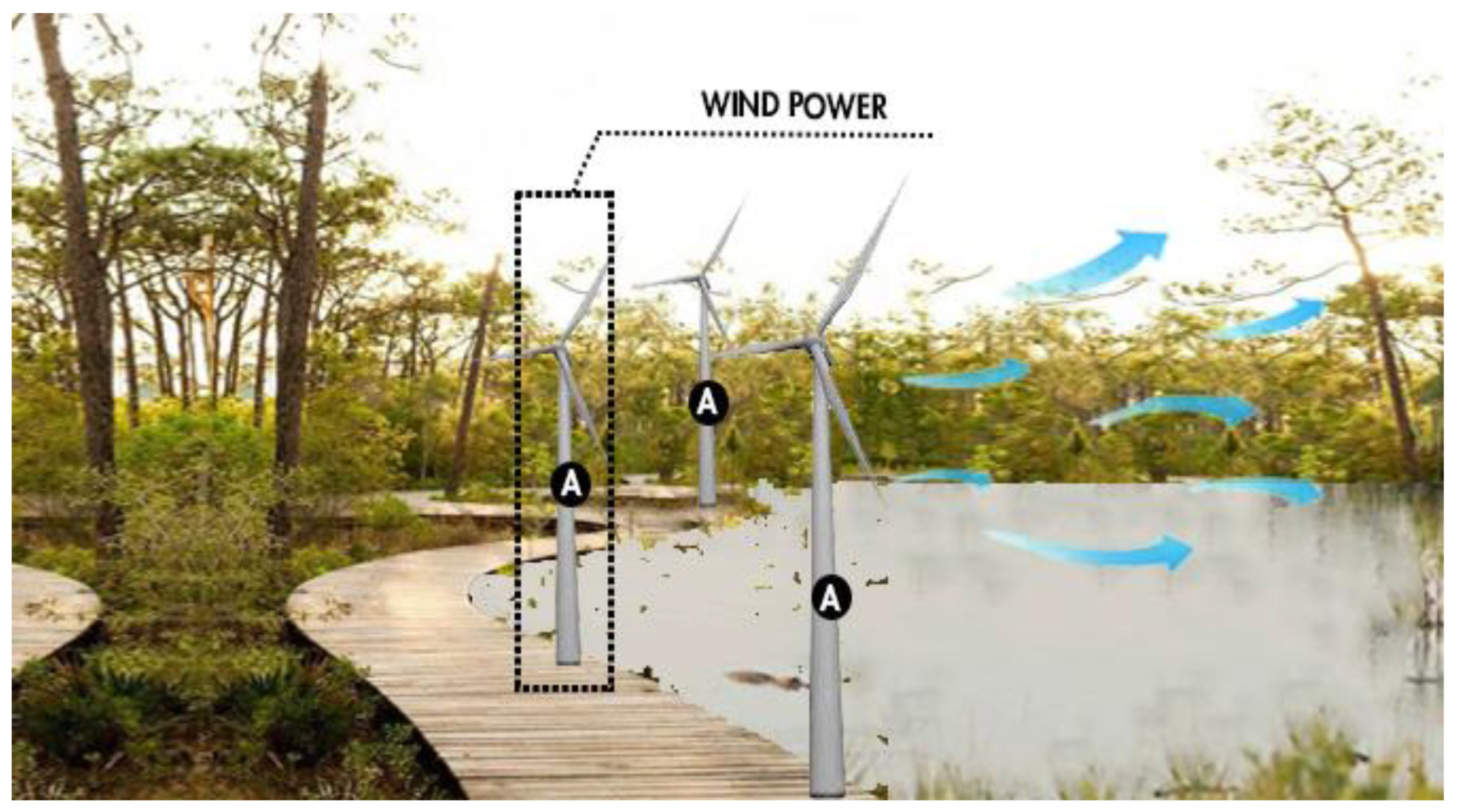
Wind energy is becoming one of the main forms of energy generation in the European energy context, standing out for being one of the least polluting and safest options. The electricity generation capacity of a wind turbine will be equivalent to that produced by 1000 kg of oil, and their implementation contributes to avoiding carbon dioxide emissions by not depending on coal. However, to achieve this process, it is necessary to build wind turbines capable of converting the kinetic energy of the wind into electricity (Figure 22).

3.6.2. Solar Panels in Public Lighting

The green infrastructure proposal includes the incorporation of streetlights equipped with solar panels. These have several qualities [50]:
  • Sustainability: They operate with solar energy—a clean and renewable source [51,52].
  • Energy conservation: Solar panels efficiently convert the sun’s energy into electricity.
  • Minimal upkeep: When set up, these systems demand minimal technical intervention, resulting in lower long-term operating costs.
  • Autonomy: Because they are powered by photovoltaic power, the lighting fixtures are capable of functioning without connection to the electrical grid, making them especially useful in remote areas or areas without access to conventional services.
  • Adaptability: Their design allows them to be implemented in urban and rural settings, such as parks, gardens, streets, or squares, providing sustainable lighting in different environments.
The installation of solar-powered lighting is distributed throughout the infrastructure pathway (see Table 4).
The route covers a distance of 5 km, along which 200 lights equipped with photovoltaic panels have been installed.
The project proposes the implementation of an autonomous lighting system as an efficient and sustainable solution to provide quality nighttime lighting along roads and communal areas and shared spaces of the projected area. This system immediately replaces traditional sodium, mercury, and metal halide luminaires, complying with Icontec, Retilap, UL, and CE regulations. In addition to ensuring high safety and performance standards, it offers a significant reduction in energy consumption, estimated at between 50% and 80%, and a lifespan of more than 10 years, making it a long-lasting and cost-effective alternative.
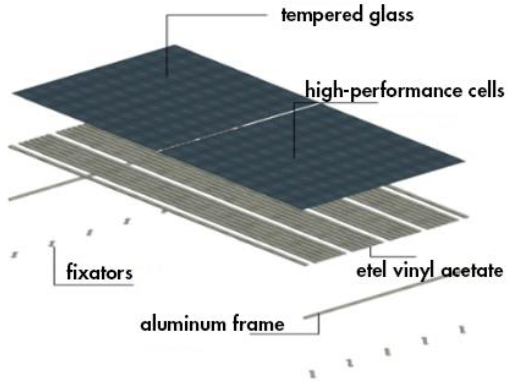
The installation contains a high-performance solar panel integrated into an arm with an LED luminaire, which has an intensity of 120 lumens per watt, power of 120 watts, and total consumption of 14,400 watts. The system is complemented by a pre-assembled structure for the mounting of the solar panel on a pole, designed for outdoor use, and includes a battery bank with a battery life of up to 3 days, a management unit, safeguards, couplings, and pole mounts (see Table 4).
Electrical parameters:
  • Luminaire power: 120 watts;
  • Luminaire intensity: 14,400 lumens;
  • Luminaire efficiency: 120 lumens per watt;
  • Tone of light: 6500 Kelvin;
  • Energy storage system: Deep-cycle battery;
  • Operating time: Up to 12 continuous hours;
  • Recommended installation height: Between 11 and 12 m;
  • Ideal pole spacing: From 25 to 28 m;
  • Light tone options: Cool tone and warm tone available.
The installation of solar lighting on the interpretive trail incorporates high-performance photovoltaic systems, with conversion efficiency of up to 23% when converting sunlight into electrical power. These panels are strategically distributed along the main circuit to maximize radiation capture in daylight hours. The energy generated is stored in batteries, allowing the lighting system to operate at night or in conditions of low solar radiation. This technology ensures efficient and sustainable lighting, adapted to the needs of the natural environment.
The figure below shows an interpretive trail in a natural setting, such as a park or reserve, equipped with public lighting using poles with solar panels (marked with the letter "A"). These panels, located at the tops of the poles, capture solar energy during the day to power the lights at night, allowing safe pedestrian access. The presence of people walking indicates the recreational and educational use of the trail. The environment is surrounded by vegetation, reflecting the sustainable integration of the lighting system with the environment. This technology is used specifically to illuminate the trail, promoting an environmentally friendly solution (see Figure 23).

3.6.3. Off-Grid Solar Power System

An off-grid solar power system operates independently from the traditional electrical grid, providing electricity through solar panels combined with battery storage. This setup captures sunlight during the day, converting it into usable energy that is stored for use at night or during periods of low sunlight. Off-grid systems are ideal for remote or rural areas without access to the main power grid, offering a reliable and sustainable energy solution that reduces the dependence on fossil fuels and lowers electricity costs. Additionally, these systems enhance energy security and promote environmental sustainability by harnessing clean, renewable solar power.
Figure 24 shows the strategic arrangement of solar panels inside the greenhouse, taking advantage of solar radiation to generate clean energy efficiently. It also presents the details and technical characteristics of the solar panels used in the project. These photovoltaic devices, by capturing solar energy and converting it into electricity, constitute a fundamental part of the renewable energy strategy implemented in the proposal (Table 5, Table 6, Table 7 and Table 8).

4. Discussion

The urban design proposal for the recovery of public spaces on the banks of the Ichu River, with the aim of raising environmental awareness, is compared with Zorrilla’s research [53] on “Articulating Edges”. Their research focuses on reflecting on the gaps that have been generated between urban and natural structures in Armenia, addressing strategies and theoretical solutions that favor the connection of these structures. Zorrilla examines the importance of nature as a public space and observes how occupation models, such as gated communities, can offer a false perception of security, contributing to the deterioration of the urban structure due to the lack of connection with the natural environment.
Zorrilla’s study highlights the relationship between urban growth and a lack of integration with nature, pointing out how certain occupation models can negatively impact the perceptions and use of public space. Their research underlines the need to recognize the particularities of the territory, especially the topographic conditions, in order to achieve coherent and sustainable urban development. In this sense, the proposal for public spaces on the banks of the Ichu River seeks to apply lessons learned from this approach, seeking to harmoniously integrate urbanization with nature, promoting environmental awareness and contributing to the well-being of the community.
The proposal seeks to offer environmental awareness strategies that positively impact the conservation of green areas and propose connectivity strategies on the banks of the Ichu River and the urban fabric to influence the development of the city. Compared to Rung-Jiun’s research [54] on “Achieving Successful River Restoration in Dense Urban Areas: Lessons from Taiwan”, a paradigm shift in river management is evident, moving from an engineering-centered approach to controlling water to a multifunctional one that seeks to restore the ecology and ecosystem services of the river.
Rung-Jiun’s research highlights the case of the Laojie River in Taiwan, transformed from a canalized urban river to linear and accessible green infrastructure. This project, while successful, reveals significant practical challenges.
This analysis highlights the importance of not only addressing environmental aspects but also considering the perceptions and concerns of the local community. The proposal for the banks of the Ichu River and the urban fabric seeks to learn from these lessons, integrating awareness-raising strategies that address both esthetic and recreational aspects, as well as risk management and water quality. Active public participation and effective communication are identified as fundamental pillars for the success of the river’s restoration and its impact on the sustainable development of the city.
Table 9 compares the proposal for the restoration of the Ichu River banks with the research of Zorrilla and Rung-Jiun, revealing a convergent approach toward the harmonious integration of urban and natural environments, albeit based on different contexts and issues. The Ichu River proposal seeks to apply theoretical and practical concepts aimed at generating environmental awareness and improving the urban fabric, learning from documented experiences. Zorrilla provides a critical perspective on urban occupation models that exclude nature as a public space, while Rung-Jiun offers a practical experience of ecological restoration in a dense and vulnerable environment, highlighting the importance of green infrastructure and citizen participation. The interrelationship between social, environmental, and territorial factors is evident: the perception of risks, safety, esthetics, and functionality directly influence the use and appropriation of space. In addition, additional factors such as the regulatory framework, urban planning, basic infrastructure, and institutional communication are identified, which can facilitate or hinder the implementation of these types of projects. Together, these approaches underscore the need to adopt comprehensive, context-sensitive, and participatory strategies to achieve sustainable transformations in urban spaces linked to water bodies.
Quantifying the impact of environmental awareness involves combining quantitative and qualitative indicators, as well as establishing baselines and periodic evaluations. To this end, behavior change indicators were measured (such as the increase in the amount of recycled waste, the reduction in illegal dumping, the rise in attendance at environmental events, and the adoption of sustainable practices at home), the level of active participation (number of people in workshops, cleanup campaigns, green space maintenance, community surveys, or participatory public space design), the monitoring of social networks and local media (reach and tone of conversations related to the project), and local governance indicators (creation of neighborhood environmental committees or inclusion of environmental topics in development plans). To clarify the causal relationship between community participation and environmental improvement, the Theory of Change was employed, breaking down the process into inputs (environmental education, participatory activities, and technical and human resources), activities (workshops, campaigns, and ecological restoration), outputs (greater knowledge, strengthened social networks, and rehabilitated spaces), outcomes (changes in attitudes and behaviors toward the environment), and impacts (improvements in environmental quality, positive perceptions of surroundings, and responsible use of public space). Likewise, the use of participatory evaluation methods—such as social mapping, community evaluation matrices, or semi-structured interviews—allowed for the collection of direct perceptions and strengthened our understanding of this relationship. In this way, it is not only feasible to measure the impact but also to demonstrate that, when communities are informed and empowered, their participation generates real and sustainable effects on the environmental context.

Research Limitations

While this study provides valuable evidence of the potential of green infrastructure for the urban and environmental restoration of the Ichu River banks, it has certain limitations that must be acknowledged. First, the results are conditioned by the specific context of Huancavelica, whose topographical, social, and economic characteristics may not directly reflect those of other cities. Further interdisciplinary studies that integrate approaches from urban planning, environmental engineering, social sciences, and digital technologies are recommended to develop models for monitoring, citizen participation, and adaptive management.

5. Conclusions

In conclusion, the urban design proposal for the recovery of public spaces on the banks of the Ichu River, with the aim of promoting environmental awareness, emerges as a valuable initiative with significant potential. By addressing the integration of green areas, connectivity, and environmental awareness, a scenario is envisioned in which the local community and visitors can enjoy a revitalized and sustainable urban environment. The proposal not only seeks to improve the esthetics and functionality of public spaces but also has the laudable purpose of educating and raising awareness among the population about the importance of environmental conservation. By integrating awareness-raising strategies, a positive impact is projected on the community’s perceptions of the natural environment, encouraging greater participation and commitment to the preservation of the Ichu River and its surroundings. The recovery of public spaces along the Ichu River will not only contribute to the quality of life of local residents, offering areas for recreation and leisure, but will also set a positive precedent for future urban projects focused on sustainability and environmental awareness. Ultimately, the proposal seeks not only to physically transform the environment but also to inspire a cultural shift towards more responsible and environmentally friendly practices in the community and beyond.
In summary, the proposal to introduce environmental awareness strategies to influence the conservation of green areas is presented as a crucial step towards a more sustainable future. By recognizing the importance of raising awareness about the fragility and vitality of our natural spaces, this initiative seeks not only to preserve green areas but also to inspire a cultural change towards more responsible and environmentally friendly practices. By involving the community in this educational process, the door is opened to active and committed participation in the protection of our environment, creating a positive impact that extends beyond specific green areas and contributes to the general well-being of society and the ecosystem.
In conclusion, the proposed connectivity strategies for the banks of the Ichu River and the urban fabric are presented as a vital element for the comprehensive development of the city. By focusing on strengthening the links between riverside spaces and the urban fabric, the aim is not only to improve mobility and accessibility but also to promote a more cohesive and sustainable urban environment. These strategies, by facilitating harmonious interaction between nature and the city, not only boost economic and social development but also enrich the quality of life of the inhabitants. By prioritizing connectivity, the foundations are laid for a more resilient, dynamic city that is adapted to the changing needs of its residents, thus promoting an urban future that embraces efficiency, equity, and harmony with the natural environment.
The research results benefit a wide range of stakeholders in both the theoretical and practical realms, consolidating its potential impact at local and international levels. On the theoretical side, this study provides relevant inputs for researchers, academics, and students in architecture, urban planning, environmental engineering, and territorial development, who are interested in sustainable approaches to urban regeneration. Its contribution to the debate on green infrastructure, environmental awareness, and participatory design in vulnerable contexts enriches the scientific body of knowledge on resilient urban planning, especially in intermediate Andean cities.
From a practical perspective, the primary beneficiaries are municipal and regional authorities, for whom this proposal offers an applicable guide for the formulation of sustainable urban projects supported by technical, social, and environmental foundations. Additionally, the local community of Huancavelica is positioned as a direct beneficiary by gaining access to renovated public spaces with improved ecological, recreational, and economic conditions.
This study’s results allow us to reaffirm the stated hypothesis, demonstrating that the design of sustainable public spaces that incorporate bioclimatic strategies, clean technologies, and local materials has a direct and positive impact on the population’s environmental awareness, the residents’ quality of life, and Huancavelica’s economic and social development. Intervention proposals along the Ichu River’s banks, such as parks, a tourist boardwalk, local product fairs, and ecological corridors, have not only shown improvements in the functionality and esthetics of the urban space but also strengthened the sense of belonging and citizen participation. This alignment between the hypothesis and the findings confirms the relevance of nature-based solutions as an effective tool for sustainable urban development in vulnerable Andean contexts.

Author Contributions

Investigation, D.E., V.V., V.R., J.C., P.A. and M.V.; Software, V.R. and D.E.; Validation, D.E. and V.R.; Methodology, V.R. All authors have read and agreed to the published version of the manuscript.

Funding

This research received no external funding.

Data Availability Statement

Data are contained within the article.

Conflicts of Interest

The authors declare no conflict of interest.

References

  1. Campoblanco, H.; Gomero, J. Importance of Rivers in the Environmental Surroundings. 2000. Available online: https://sisbib.unmsm.edu.pe/bibvirtual/publicaciones/geologia/v03_n5/imp_rios.htm (accessed on 20 April 2024).
  2. Green Ecology. Why Rivers and Lakes Are Important. 2021. Available online: https://www.ecologiaverde.com/por-que-son-importantes-los-rios-y-lagos-1329.html (accessed on 20 June 2024).
  3. UN Environment Protection Program Four Reasons to Protect Rivers. 2024. Available online: https://www.unep.org/es/noticias-y-reportajes/reportajes/cuatro-razones-para-proteger-los-rios#:~:text=Los%20nutrientes%20transportados%20por%20los,agua%20dulce%2C%20sec%C3%BAn%20el%20WWF (accessed on 15 July 2023).
  4. TeleSURtv.net. Importance of River Conservation for the Earth. 2024. Available online: https://www.telesurtv.net/importancia-de-la-conservacion-de-los-rios-para-la-tierra/ (accessed on 15 July 2023).
  5. WWF. Why Are Rivers More than Just Sources of Water? 2022. Available online: https://www.wwf.org.co/?379150/Por-que-los-rios-son-mas-que-fuentes-de-agua (accessed on 18 July 2024).
  6. National Geographic. Rivers and Lakes Are the Most Degraded Ecosystems in the World. Can We Save Them? 2021. Available online: https://www.nationalgeographicla.com/medio-ambiente/2021/03/los-rios-y-los-lagos-son-los-ecosistemas-mas-degradados-del-mundo (accessed on 17 July 2023).
  7. NRDC. Water Pollution: Everything You Need to Know. 2023. Available online: https://www.nrdc.org/es/stories/contaminacion-agua-todo-lo-necesitas-saber (accessed on 23 June 2024).
  8. Escobar, J. River Pollution and Its Effects on Coastal Areas and the Sea. 2002. Available online: https://archivo.cepal.org/pdfs/Waterguide/LCL1799S.PDF (accessed on 12 June 2024).
  9. Baquerizo, M.; Acuña, M.; Solis-Castro, M. River Pollution: The Case of the Guayas River and Its Tributaries. 2019. Available online: https://www.researchgate.net/publication/334530588_Contamination_of_river_case_Guayas_river_and_its_affluent (accessed on 30 June 2023).
  10. Care. Water Shortages: One of the Greatest Challenges of the 21st Century. 2021. Available online: https://care.org.pe/escasez-de-agua-uno-de-los-mayores-desafios-del-siglo-xxi/ (accessed on 28 June 2024).
  11. Unicef. 1 in 3 People in the World Do Not Have Access to Safe Drinking Water. 2019. Available online: https://www.unicef.org/es/comunicados-prensa/1-de-cada-3-personas-en-el-mundo-no-tiene-acceso-a-agua-potable (accessed on 25 June 2024).
  12. World Bank Group. Water. 2023. Available online: https://www.worldbank.org/en/topic/water/publication/global-water-security-and-sanitation-partnership-annual-report-2023 (accessed on 18 October 2024).
  13. UN. Water Scarcity, Climate Crisis and Global Food Security: A Call for Collaborative Action. 2023. Available online: https://www.un.org/en/un-chronicle/water-scarcity-climate-crisis-and-global-food-security-call-collaborative-action (accessed on 27 April 2024).
  14. Aquae Foundation. Causes of Water Scarcity in the World. 2024. Available online: https://www.fundacionaquae.org/wiki/escasez-de-agua-en-el-mundo-naciones-unidas-advierte-que-la-demanda-crecera-hasta-un-30-por-ciento-en-2050/ (accessed on 28 June 2024).
  15. IDB Improving Lives. Rivers as an Axis of Socio-Economic Transformation of Cities. 2015. Available online: https://blogs.iadb.org/ciudades-sostenibles/es/rios-transformacion-socioeconomica-ciudades-valledupar/ (accessed on 28 July 2024).
  16. Intedya. 70% of Water in Latin America Suffers from Contamination Problems. 2014. Available online: https://www.intedya.com/internacional/145/noticia-el-70-del-agua-en-latinoamerica-sufre-problemas-de-contaminacion.html (accessed on 28 June 2024).
  17. A Bluer Planet. The Drama of River Pollution in Latin America. 2022. Available online: https://www.masazulplaneta.com.ar/2023/01/08/el-drama-de-la-contaminacion-de-los-rios-en-america-latina/ (accessed on 25 April 2024).
  18. Educational Folder. Importance of the Rivers of Peru. 2020. Available online: https://carpetapedagogica.com/importanciadelosriosdelperu (accessed on 25 May 2024).
  19. Aqua Fondo. Learn About the Main Rivers in Lima and Their Importance. 2022. Available online: https://aquafondo.org.pe/conoce-los-principales-rios-de-lima-y-su-importancia/ (accessed on 20 June 2024).
  20. Infobae. The Water from the River That Supplies All of Lima Contains Dangerous Levels of Lead, Copper and Arsenic. 2024. Available online: https://www.infobae.com/peru/2024/07/17/el-agua-del-rio-que-abastece-todo-lima-contiene-niveles-peligrosos-de-plomo-cobre-y-arsenico/ (accessed on 28 June 2024).
  21. Huarcaya, J. Ichu River. 2018. Available online: https://es.scribd.com/document/460684558/Rio-Ichu (accessed on 15 April 2025).
  22. Regional Government of Huancavelica. Hydrological Study of the Ichu River Sub-Basin. 2020. Available online: https://sinia.minam.gob.pe/sites/default/files/siar-huancavelica/archivos/public/docs/hidrologia_rio_ichu-completo_0.pdf (accessed on 20 April 2025).
  23. Conde, E. Integrated Management Plan for Sustainable Management of the Ichu River Sub-Basin, Huancavelica Province. 2016. Available online: https://repositorio.uncp.edu.pe/bitstream/handle/20.500.12894/4574/Linio%20E..pdf?sequence=1&isAllowed=y (accessed on 18 April 2024).
  24. Lopez, M. Extracción del Material en el río Ichu y el Impacto Antropogénico centro Poblado Calqui Chico–Huancavelica. 2023. Available online: https://alicia.concytec.gob.pe/vufind/Record/RUNH_21f701a6b7f43eebbc57cc078f42cb02. (accessed on 15 June 2024).
  25. Diario Correo. Ichu River, Unprotected from Pollution. 2015. Available online: https://diariocorreo.pe/peru/rio-ichu-desprotegido-de-la-contaminacion-608776/?ref=dcr (accessed on 18 July 2024).
  26. Available online: https://apirepositorio.unh.edu.pe/server/api/core/bitstreams/d4b19716-446d-47d5-974c-74925a7e57fa/content (accessed on 18 July 2024).
  27. Available online: https://www.researchgate.net/publication/367034921_CALIDAD_DEL_AGUA_DEL_RIO_ICHU_EN_ZONAS_URBANAS_DEL_DISTRITO_DE_HUANCAVELICA_SEGUN_ICA-NSF (accessed on 18 July 2024).
  28. Davila, V. Concentration of Phosphates and Nitrates in the Ichu River, Urban Part of the Huancavelica District. Available online: https://www.google.com/url?sa=i&url=https%3A%2F%2Fdialnet.unirioja.es%2Fdescarga%2Farticulo%2F10197465.pdf&psig=AOvVaw1n67FZ3uogAGHJ7XukPHMH&ust=1754173740415000&source=images&cd=vfe&opi=89978449&ved=0CAYQrpoMahcKEwiQjvrG1OqOAxUAAAAAHQAAAAAQBA (accessed on 27 June 2024).
  29. Franco, L. Identification of Pollution Sources and Analysis of Water Quality in a Segment of the Ichu—Huancavelica River. 2016. Available online: https://repositorio.uap.edu.pe/bitstream/handle/20.500.12990/1433/Tesis_Identificaci%c3%b2n_Fuentes%20Comunicaci%c3%b2n_An%c3%a0lisis%20Calidad.pdf?sequence=1&isAllowed=y (accessed on 27 June 2024).
  30. García, R. Wastewater and Urban Solid Waste and Its Impact on the Pollution of the Ichu River in the Town of Huancavelica. 2018. Available online: https://repositorio.unh.edu.pe/items/4ea99a57-22c8-4c7d-bc89-f382d1aa5d63 (accessed on 27 June 2024).
  31. Aliaga, M.; Carbajal, N.; Solis, E. Effect of Population Wastewater Discharge on the Organic Load and Thermotolerant Coliforms of the Ichu River, Acoria-Huancavelica District—2021. 2021. Available online: https://repositorio.continental.edu.pe/bitstream/20.500.12394/11135/1/IV_FIN_107_TE_Aliaga_Carbajal_Solis_2021.pdf (accessed on 27 June 2024).
  32. Huamaní, L.; Chávez, E.; Sánchez, V.; Sáez, W. Organic matter assessment of the Ichu River micro-basin, Peru. Univ. Soc. J. 2022, 14, 588–596. [Google Scholar]
  33. Márquez González, A.R.; Sánchez Crispín, Á. Turismo y ambiente: La percepción de los turistas nacionales en Bahía de Banderas, Nayarit, México. Investig. Geogr. 2007, 64, 134–152. [Google Scholar]
  34. Gobierno Regional de Huancavelica. REPRESA EN RÍO ICHU GARANTIZARÁ AGUA POTABLE Y PARA RIEGO POR MÁS DE 50 AÑOS. 2023. Available online: https://old.regionhuancavelica.gob.pe/index.php/servicios/noticias/noticias-junio-23/4011-rio-ichu-23 (accessed on 15 June 2024).
  35. Velázquez Ruiz, A.; Martínez, L.M.; Carrillo González, F.M. Caracterización climática para la región de Bahía de Banderas mediante el sistema de Köppen, modificado por García, y técnicas de sistemas de información geográfica. Investig. Geogr. 2012, 79, 7–19. [Google Scholar] [CrossRef]
  36. Esenarro, D.; Vasquez, P.; Morales, W.; Raymundo, V. Interpretation Center for the Revaluation of Flora and Fauna in Cusco, Peru. Buildings 2023, 13, 2345. [Google Scholar] [CrossRef]
  37. Deeksha; Shukla, A.K. Ecosystem Services: A Systematic Literature Review and Future Dimension in Freshwater Ecosystems. Appl. Sci. 2022, 12, 8518. [Google Scholar] [CrossRef]
  38. Li, X.; Gong, S.; Shi, Q.; Fang, Y. A Review of Ecosystem Services Based on Bibliometric Analysis: Progress, Challenges, and Future Directions. Sustainability 2023, 15, 16277. [Google Scholar] [CrossRef]
  39. Tang, J.; Fang, Y.; Tian, Z.; Gong, Y.; Yuan, L. Ecosystem Services Research in Green Sustainable Science and Technology Field: Trends, Issues, and Future Directions. Sustainability 2023, 15, 658. [Google Scholar] [CrossRef]
  40. Tavares-Martínez, R.A.; Fitch-Osuna, J.M. Community planning in socially vulnerable neighborhoods. Identification of social actors in a community. Rev. Arquit. 2019, 21, 22–32. [Google Scholar] [CrossRef]
  41. Rodriguez Armenta, M. Urban actors and public policies. Polit. Cult. 2008, 257–261. [Google Scholar]
  42. Nunez, J.M. Spatial analysis of urban green areas in Mexico City. Econ. Soc. Territ. 2021, 21, 803–833. [Google Scholar] [CrossRef]
  43. Guaita García, N.; Martínez Fernández, J.; Fitz, C. Environmental Scenario Analysis on Natural and Social-Ecological Systems: A Review of Methods, Approaches and Applications. Sustainability 2020, 12, 7542. [Google Scholar] [CrossRef]
  44. Soto-Velasquez, M.E.; Mascaro Collantes, G.J.; Gonzalez-Acuna, V.H. Urban planning in the public management of local governments in Peru. Quipukamayoc 2023, 31, 31–39. [Google Scholar] [CrossRef]
  45. Ferreiro, R.M. Biophysical profile: A test of fetal well-being. Rev. Cuba. Obstet. Ginecol. 1999, 25, 77–82. [Google Scholar]
  46. Jiménez Caldera, J.E.; Durango Severiche, G.Y. Diagnosis and planning of urban public space. The participation of citizen users. Bitácora Urbano Territ. 2021, 31, 257–281. [Google Scholar] [CrossRef]
  47. Rodrigo-Comino, J.; Taguas, E.V.; Seeger, M.K.; Ries, J.B. Evaluación de los procesos superficiales de escorrentía en cárcavas originadas en olivares convencionales. Un apartado a tener en cuenta en la planificación territorial. Rev. Geogr. Norte Gd. 2019, 74, 229–248. [Google Scholar] [CrossRef]
  48. Castro Fresno, D.; Rodríguez Bayón, J.; Rodríguez Hernández, J.; Ballester Muñoz, F. Sistemas urbanos de drenaje sostenible (Suds). Interciencia 2005, 30, 255–260. [Google Scholar]
  49. Chacón-Avilés, R.; Meza-Benavides, C.; AC-Braga, H.; S-Almeida, P.; G-Casagrande, C. Proceso de diseño de sistemas de iluminación LED energéticamente autóno-mos. Tecnol. Marcha 2017, 30, 52–65. [Google Scholar]
  50. Guillot, J.; Viloria, A. Study on the Constant Supply of Wind Energy. Investig. Innov. Eng. 2015, 3, 2. [Google Scholar]
  51. Terrero Matos, E.; Legrá Lobaina, A.A.; Lamorú Reyes, A. Inverse power of distance method for estimating wind speed. Eng. Energ. 2014, 35, 263–273. [Google Scholar]
  52. Raymundo, V.; Esenarro, D.; Rodríguez, C.; Davila, S.; Prado, M.; Veliz, M. Biodigester Application to Generate Electricity and Improve the Quality of Life. In Proceedings of the 7th ASRES International Conference on Intelligent Technologies, ICIT 2022, Jakarta, Indonesia, 16–18 December 2022; Lecture Notes in Networks and Systems; Arya, K.V., Tripathi, V.K., Rodriguez, C., Yusuf, E., Eds.; Springer: Singapore, 2023; Volume 685. [Google Scholar]
  53. Zoriilam, A. Articulating Edges: Spaces for the Recovery and Integration of the Ravines Into the Urban Environment of the City of Armenia, Quindío. 2021. Available online: https://repositorio.unal.edu.co/items/82dc7be2-b60a-4ce9-9459-cc0339fd66a5 (accessed on 25 June 2024).
  54. Chou, R.-J. Achieving Successful River Restoration in Dense Urban Areas: Lessons from Taiwan. Sustainability 2016, 8, 1159. [Google Scholar] [CrossRef]
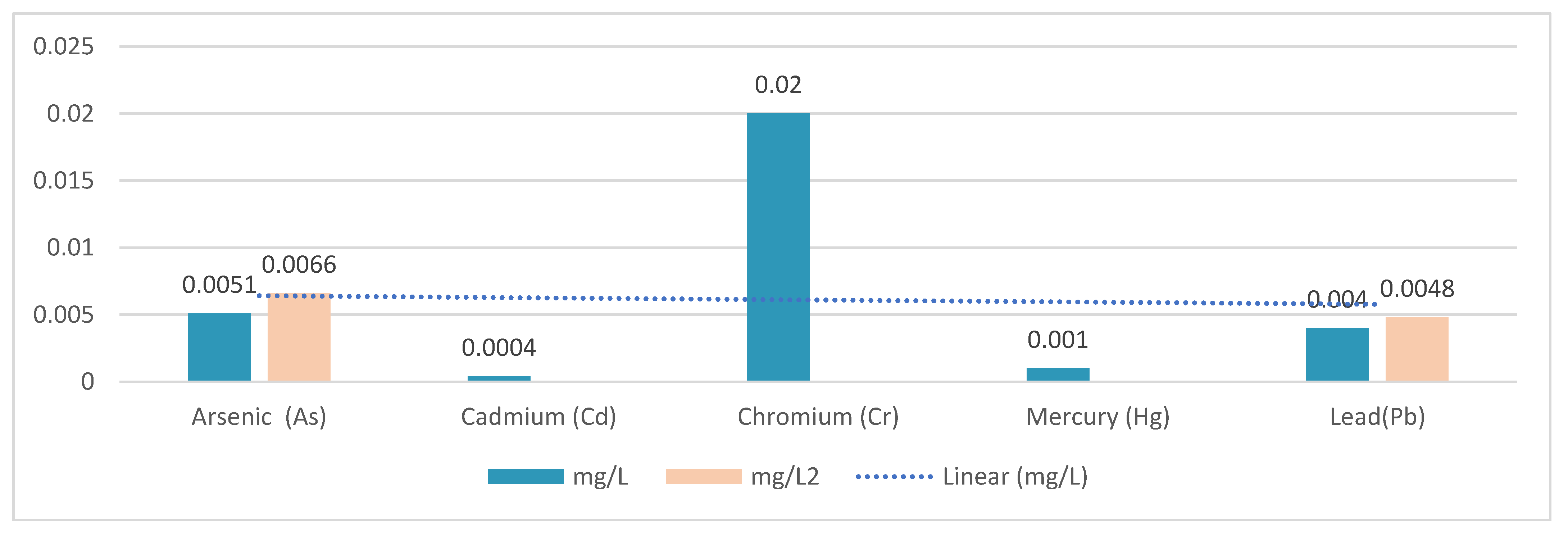
Figure 1. Heavy metal levels detected.
Buildings 15 03120 g001
Figure 2. (a) Banderas Bay; (b) Henares Corridor; (c) Ring of Starlight.
Buildings 15 03120 g002
Figure 3. Methodological process in research.
Buildings 15 03120 g003
Figure 4. Steps for implementing the proposal.
Buildings 15 03120 g004
Figure 5. Location of the intervention site.
Buildings 15 03120 g005
Figure 6. Main rivers in the area of intervention.
Buildings 15 03120 g006
Figure 7. Flora and fauna present in the department of Huancayo.
Buildings 15 03120 g007
Figure 8. Bioclimatic analysis of the intervention site.
Buildings 15 03120 g008
Figure 9. Psychometric abacus of the intervention site.
Buildings 15 03120 g009
Figure 10. Location of the intervention area and accessibility.
Buildings 15 03120 g010
Figure 11. (a)View of Avenue 1 of the Ichu River. (b) View of Avenue 2 of the Ichu River.
Buildings 15 03120 g011
Figure 12. Master plan of the urban proposal.
Buildings 15 03120 g012
Figure 13. Cross-section of the Ichu River reforestation project.
Buildings 15 03120 g013
Figure 14. Project tour.
Buildings 15 03120 g014
Figure 15. View of the pier route.
Buildings 15 03120 g015
Figure 16. Implementation of organic pergolas. (A) View of the public spaces with the implementation of organic pergolas; (B) view of the organic pergolas as a function of sunlight.
Buildings 15 03120 g016
Figure 17. Implementation of green areas, bamboo forest, and agricultural area.
Buildings 15 03120 g017
Figure 18. Views of the ecomuseum. (A) Interior view of the ecomuseum and the use of local materials. (B) Sectional view of the ecomuseum and the passive bioclimatic strategy for natural ventilation.
Buildings 15 03120 g018
Figure 19. Temporary residence and greenhouse.
Buildings 15 03120 g019
Figure 20. View of the sensory garden.
Buildings 15 03120 g020
Figure 21. Materials used in the project.
Buildings 15 03120 g021
Figure 22. Off-grid solar energy system.
Buildings 15 03120 g022
Figure 23. Solar panels for public lighting along the interpretive trail.
Buildings 15 03120 g023
Figure 24. Solar panels installed in the greenhouse.
Buildings 15 03120 g024
Table 1. Urban landscape regeneration strategies.
Strategies for Urban Landscape Regeneration
PhaseAspectImplementationDescription
Phase 1Physical Appearance In this phase, efforts will focus on infrastructure and urban design. This will include the construction and renovation of roads, parks, and recreational areas. Sustainable materials and green building techniques will be implemented to reduce environmental impacts. Lighting installations and appropriate street furniture will also be incorporated to encourage the safe and consistent use of these spaces.
Phase 2Biophysical Aspects The biophysical phase will focus on the restoration and conservation of the natural environment. Reforestation with native species will be carried out to recover local biodiversity and stabilize the banks of the Ichu River. In addition, sustainable drainage systems will be implemented to improve water quality and prevent erosion. The creation of ecological corridors and the promotion of sustainable agricultural practices will also be part of this stage, ensuring a balance between urban development and ecosystem conservation.
Phase 3Social Aspects The social approach will seek to strengthen community cohesion and improve the quality of life of residents. Workshops and environmental education programs will be organized to foster a sense of belonging and active community participation in the conservation of the recovered spaces. In addition, cultural and recreational activities will be promoted that integrate people of all ages, creating an inclusive and vibrant environment. Collaboration with local organizations and the implementation of social economy initiatives, such as community markets and sustainable tourism projects, will boost the economic and social development of the area.
Table 2. Amount of CO2 absorbed and air purification.
Landscaped Green Area in Green Corridor (ha2)CO2 Absorbed (kg)Fresh Air Produced (kg)
124.63.4
Total24.63.4
Table 3. Urban landscape regeneration strategies.
Green Bamboo Forest Area (ha2)CO2 Absorbed
(tons)
11.838.53
Total1.838.53
Table 4. Monthly energy consumption and energy efficiency derived from the installation of solar panels in lighting systems, compared to traditional lighting fixtures in circuits.
Traditional Solar Lighting UnitSolar Lighting UnitConventional Solar Luminaire,
Months (30 Days)
Luminaire with Solar Panel,
Months (30 Days)
Amount20 Classic Solar Lighting Units20 Solar Panel Light Fixtures
C1120 watts/12 h250 watts/12 h14403000200288,000600,000
Total 288,000600,000
Table 5. Features of the photovoltaic panel.
Features of the Photovoltaic Panel
Greenhouse143.92 m2
Photovoltaic Panel Performance75.23 kw
Solar Panel Potential2000 w
Dimensions955 × 530 × 25 mm
Table 6. Working performance of photovoltaic panel.
ParameterMonocrystalline
HSPWork Efficiency (w)Module Potential (W)Module Potential (Wh/day)
1.3275,2302000715,598 × 103
Table 7. Performance per day.
Wh/dayConversionKwh/day
715,598 × 1031389.88 × 1010
Table 8. Monthly performance.
Wh/dayConversionKwh/day
9.88 × 10101000.009.88 × 107
Wh/dayDaily (Kwh)Monthly (Kwh/day)
9.88 × 10101000.009.88 × 107
Table 9. Comparative analysis of the projects analyzed.
AspectIchu River ProposalZorrilla—“Edge Articulation”Rung-Jiun—Restoration in Taiwan
Main ObjectiveRecovery of public spaces and raising environmental awareness.Reflect on the urban–natural disconnection and promote their integration.Restore dense urban rivers from a multifunctional approach.
Central ApproachUrban–natural integration with community participation.Recognition of the value of nature as public space.Ecological and landscape restoration with public participation.
Identified IssuesLack of connection between river and city; low environmental awareness.Exclusionary occupation models; false sense of security; urban deterioration.Rigid river channelization; risk perception; lack of sanitary infrastructure.
Social Factors InvolvedActive community participation; citizens’ perception as a core aspect.Perception of public space; closed occupation models.Social acceptance linked to esthetic/recreational aspects; lack of effective communication with authorities.
Environmental Factors InvolvedGreen area conservation; improvement of water quality.Integration of natural elements into urban areas, considering topography.Restoration of the river’s ecosystem services.
Infrastructure and TerritoryNeed for connectivity between riverbank and urban fabric.Relevance of the area’s topographic conditions.Lack of adequate sewage network throughout the basin.
Urban-Nature RelationshipPromotes harmonious integration to improve urban quality of life.Criticizes the physical and symbolic separation between the city and nature.Transition from rigid channelization to integrated green infrastructure.
Lessons LearnedTerritorial integration and environmental awareness are key to community well-being.Recognizing territorial characteristics allows for more coherent urban development.Restoration must consider risk perception, esthetics, infrastructure, and public communication.
Additional Influencing FactorsRegulatory frameworks, institutional support, environmental education, financing.Urban policy, access to public spaces, strategic planning.Risk management, technical capacity, interinstitutional coordination.
Key InterrelationshipsEnvironmental awareness, community participation, use and care of space.Urban form, safety perception, social exclusion, environmental deterioration.Ecological restoration, public perception, risk management, basic infrastructure.
Disclaimer/Publisher’s Note: The statements, opinions and data contained in all publications are solely those of the individual author(s) and contributor(s) and not of MDPI and/or the editor(s). MDPI and/or the editor(s) disclaim responsibility for any injury to people or property resulting from any ideas, methods, instructions or products referred to in the content.