Abstract
Traditional methods for documenting cultural heritage often remain inadequate for preserving structural data, making it virtually impossible to archive architectural works that no longer survive. This study investigates the use of augmented reality (AR) technology to improve the sustainability of architectural heritage in the digital environment. The former People’s House (Halkevi) building, once located in Konya, Türkiye but no longer standing, was selected as the case study. Drawing on available photographs and historical documents, a 3D model of the building was generated using Autodesk Revit, further refined in 3ds Max, and transferred to an interactive digital platform via AR applications (ARki, Augmentecture, and a custom AR solution developed with Unity 3D + Vuforia). These applications offer an accessible solution for art and architectural historians thanks to their user-friendly interfaces and the fact that they do not require coding knowledge. Among the tested AR platforms, the Unity + Vuforia-based application yielded the most consistent performance, especially in terms of interactivity, visual stability, and environ-mental integration. The findings indicate that augmented reality can serve as a practical tool for the digital documentation of cultural heritage, demonstrating that researchers without advanced technical expertise can effectively utilize these technologies. This study contributes to digital heritage preservation by proposing a simplified AR-based methodology that reduces the need for cross-disciplinary expertise, enabling wider participation of local stakeholders in the documentation and visualization of lost architectural heritage.
1. Introduction
Documenting architectural heritage involves not only recording the physical form of structures but also preserving their cultural and contextual significance [,,]. Conventional archiving based on physical materials risks deterioration and loss over time. In particular, for heritage structures that no longer exist physically today, the limitations of archival resources necessitate the adoption of alternative visualization techniques [,].
AR has become a key tool for documenting and re-visualizing heritage. These technologies not only serve technically proficient professionals but also offer practical and accessible solutions for researchers in fields such as art history and architectural history, who may have limited experience in digital design and programming [,,]. The interactive visualization capabilities provided by AR facilitate the reconstruction of models using archival documents, historical photographs, and written records, thereby contributing to their circulation within both academic and cultural spheres [,].
The core research problem of this study lies in addressing how cultural heritage buildings that have completely disappeared can be preserved and transmitted through accessible digital methods. Among such structures, the Konya People’s House (Halkevi) was chosen as a case study because of its symbolic significance in the early Republican period of Türkiye. As one of the first People’s Houses established in 1932, the building played a central role in the dissemination of cultural, educational, and social reforms, functioning as a hub for literacy, artistic activities, and collective memory. Its demolition and absence today present a critical challenge not only for architectural documentation but also for safeguarding the intangible heritage associated with the modernization policies of the Republic. Accordingly, this research emphasizes the importance of digitally reconstructing the Konya People’s House as both a methodological experiment and a response to the broader problem of preserving lost heritage.
In this study, the potential of AR technology for documenting architectural heritage is explored through the example of the Konya People’s House (Halkevi) Building—constructed as part of the Republic period’s social transformation projects but no longer extant today. Based on a limited number of archival photographs and written documents, the building was digitally modeled using Autodesk Revit 2023 and 3ds Max 2023 software and subsequently transferred to an AR environment via the Unity platform. The model was tested through mobile AR applications such as ARki, Augmentecture, and a custom Unity 3D 2021.3.36f1 (LTS) + Vuforia 10.22.5 (Unity package) solution. Considering the limitations of these existing tools, a new AR prototype was developed as an alternative model. In this context, the primary aim of this study is to present an accessible method that enables disciplines less familiar with digital technologies to benefit from AR, thereby supporting the digital sustainability of lost architectural heritage.
Despite the growing number of studies on AR-based heritage documentation, most approaches require advanced coding or cross-disciplinary expertise, which limits their accessibility for researchers in the humanities. This study addresses this gap by asking: How can AR technologies be simplified and adapted to allow non-technical users, such as art and architectural historians, to actively participate in the digital preservation of lost heritage? By tackling this question, the research positions itself as a methodological contribution that extends the usability of AR beyond technically specialized domains.
2. The Role of Augmented Reality Technologies in Documenting Cultural Heritage
The digital documentation and presentation of cultural heritage play a key role beyond aesthetics, as they enable the structuring, interpretation, and dissemination of scientific datasets [,,]. Visualization techniques make reproducible objects meaningful for scientific communities while ensuring accuracy and reliability []. Their effectiveness lies not only in the rapid transmission of information but also in fostering insights that help users build mental models [,,].
The distinction among data, information, and scientific visualization is crucial for disciplines in this field, as these concepts, though often used interchangeably, differ in content and methodology [,]. Data visualization refers to structured representation based on attributes and variables, while information visualization involves methods for analyzing abstract data through interactive interfaces. Scientific visualization, in contrast, focuses on physical phenomena, mathematical models, and glyph-based structures [,,,,,,].
Within this framework, the use of VR and AR technologies for transferring cultural heritage into digital environments has grown considerably []. Although often seen as a recent trend, their origins date back to the 1950s with Morton Heilig’s “Sensorama”, considered the first interactive virtual environment []. Today, VR/AR are applied not only in entertainment and gaming but also in the preservation, presentation, and accessibility of cultural heritage [,,,,,,,,,,,,,,,,,].
Recent studies highlight diverse applications of AR for reviving lost or deteriorated heritage. Fornés et al. (2023) [] reconstructed the ruins of Ademuz Castle in Valencia with AR/VR, while Anay et al. (2023) [] developed an AR model to enhance visitor experiences at the Alexandria Troas site. Banfi et al. (2020) [] digitized the Tomb of Caecilia Metella to sustain Italy’s tourism sector during the COVID-19 pandemic. Cannella et al. (2022) [] virtually reconstructed a Tribuna element in Palermo Cathedral, and Spallone et al. (2022) [] applied AR/VR to recreate missing parts of a Buddha statue in the Museum of Oriental Art, Turin.
A review of the relevant literature reveals that the digitization of cultural heritage typically relies on existing building remains or photogrammetric data. However, two exceptional studies in this field have succeeded in virtually reconstructing non-extant structures based solely on archival data. One such notable example is the study by Günay (2022) [], who digitally visualized lost buildings in Izmir and Thessaloniki using a limited set of historical photographs and written documents and applied VR/AR technologies to bring these structures back to life. Using the Image-Based Modeling (IBM) method, the buildings were modeled in SketchUp and then processed in Twinmotion for immersive visualization (Figure 1 and Figure 2).

Figure 1.
The digital reconstruction process of St. George Church by overlaying historical cartographic documents; the modeling was carried out using SketchUp [].

Figure 2.
Two architectural examples digitally reconstructed in SketchUp using the Image-Based Modeling (IBM) technique: the London Hotel (left) and the Smyrna Theatre (right); both structures were recreated virtually based on a limited number of archival photographs and written sources [].
In this regard, augmented reality technologies have become effective tools not only for the preservation of physically extant architectural heritage structures but also for the revival and sustainability of structures that survive only in historical documents.
In their study, Dewitz et al. (2019) [], examined the Gothic Sophienkirche in Dresden, Germany, a significant example of 13th-century architecture that survived various interventions until the early 1960s but was later completely demolished. The researchers not only virtually reconstructed this structure but also developed the “Urban History 4D” system, which aims to ensure the sustainability of urban memory in the digital realm. Historical photographs of Dresden were digitally scanned, overlaid with a simplified 3D model of the city map, and systematically analyzed based on their shooting angles and spatial positions (Figure 3).

Figure 3.
Archival photographs positioned with spatial accuracy in the “Urban History 4D” platform (left) and the angular distribution chart illustrating the shooting directions (right) [].
In this system, the visual representations of buildings were matched with their spatial locations, and metadata such as the number of photographs, their shooting angles, and associated structures were integrated into the digital platform. Additionally, heat maps were created using this information, allowing researchers to identify which buildings or areas were most frequently photographed and from which perspectives. This integrated system not only provides a foundation for 3D visualization processes but also serves as an interactive digital platform that facilitates access to historical photographs for researchers across disciplines. Furthermore, the virtual reconstruction of the Sophienkirche was realized using AR technology, enabling the structure’s original form to be experienced digitally (Figure 4 and Figure 5).

Figure 4.
Heat map showing the spatial density and frequency of the historical images integrated into the system; areas associated with more documented structures are color-coded accordingly [].

Figure 5.
The abstract 3D digital model of the Sophienkirche generated from existing data and its integration with AR technology to produce a virtual output [].
This literature review demonstrates that AR technology is recognized as an effective tool, particularly for digitizing architectural and cultural heritage elements that have entirely disappeared physically. In this regard, the present study aims to digitally reconstruct the Konya People’s House (Halkevi) Building in Turkey—a structure that no longer exists physically but which holds significant historical value within local and national education policies. Archival research revealed that only a few historical photographs of specific facades and a limited number of written documents were available. Based on this restricted dataset, a virtual reconstruction of the building was achieved, thereby proposing a digital preservation model to prevent the complete loss of heritage assets with severely limited documentation. Furthermore, following the methodological approach presented by Günay (2022) []—which emphasizes generating modeling data through Image-Based Modeling (IBM) before developing an AR application—previously unpublished visual materials related to the Konya People’s House were processed technically. These materials were made accessible and experienceable via mobile devices, contributing to the preservation of the structure’s cultural memory and its transmission to future generations in a sustainable digital format.
Beyond the technological perspective, it is also necessary to emphasize the historical and cultural significance of the case study selected in this research, namely the Konya People’s House (Halkevi).
The Konya People’s House, established in 1932, represents one of the earliest examples of the nationwide People’s House movement initiated during the early Republican era in Türkiye. These institutions were designed to promote literacy, disseminate cultural and social reforms, and function as hubs of modernization and civic engagement. The Konya People’s House, with its library, concert hall, and educational facilities, served as a focal point for cultural and intellectual life in the city. Its complete demolition in later decades not only erased a significant architectural landmark but also left a gap in the cultural memory of the region. For this reason, the building constitutes an important case for exploring how augmented reality can contribute to the digital preservation of architectural heritage that has been entirely lost.
3. Developed Methodology
3.1. Case Studies
This research focuses on the Konya People’s House (Halkevi), a building that no longer exists today. The case was selected due to its representative value as one of the earliest People’s Houses constructed in the early Republican period. Archival visual materials, including unpublished photographs from private collections, were used as the main sources for the reconstruction process. Despite limitations such as the lack of original drawings and the black-and-white nature of photographs, the available data provided a sufficient basis for creating a digital model to be tested in AR environments.
The Konya People’s House was chosen primarily because its complete demolition left no surviving architectural documentation, creating a critical challenge for digital preservation. Limited photographs and written records were analyzed to reconstruct the building’s spatial organization. This scarcity of data underscores the importance of developing accessible methodologies for reviving architectural heritage that has otherwise been erased [].
3.2. Significance of the Konya (Türkiye) People’s House Building
Following the proclamation of the Republic in 1923, Türkiye embarked on a significant socio-political transformation process, with public education placed at the core of this modernizing agenda. Under the leadership of Mustafa Kemal Atatürk, various educational policies were developed to raise the educational level of the population, build a contemporary social structure, and disseminate the principles of the republican revolutions across society. In this context, the People’s Houses (Halkevleri) were officially established on 19 February 1932 by decision of the Grand National Assembly of Türkiye, launching a major social education initiative aimed at supporting individual development, securing public endorsement of the reforms, and promoting cultural advancement [].
The People’s Houses were designed to spread the fundamental values of the Republic to all segments of society, with the mission of fostering “national culture”, strengthening “social equality”, and supporting the “modernization of the nation” []. Within this framework, the Konya People’s House began its activities in 1932, initially operating from a temporary building located near the government mansion. However, due to rapidly increasing interest and participation, it was relocated to a larger building within the same year [].
The Konya People’s House building was constructed with three floors, comprising a basement, ground floor, and first floor. The basement served as storage, the ground floor housed a library, and the first floor was used as a concert and conference hall. Individual rooms within the building were allocated for administrative purposes. Given the proximity of the adjacent Military Officers’ Club (Orduevi), national celebrations were also organized inside this building []. The People’s House functioned as a crucial intellectual hub for the people of Konya at the time, providing a rich library that supported literacy initiatives and offered students a resource for their studies []. The Konya People’s House Library was instrumental in communicating the ideals of the Republican reforms to wider audiences and became an integral component of the early modernization process.
In later years, the structure, which was also repurposed as a municipal cinema, did not survive to the present day []. However, this study presents previously unpublished archival photographs related to the building; Figure 6 includes both original visuals from Hasan Çopur’s private collection and images already documented in the literature. These visual materials have enabled a more comprehensive documentation of the building’s historical context.
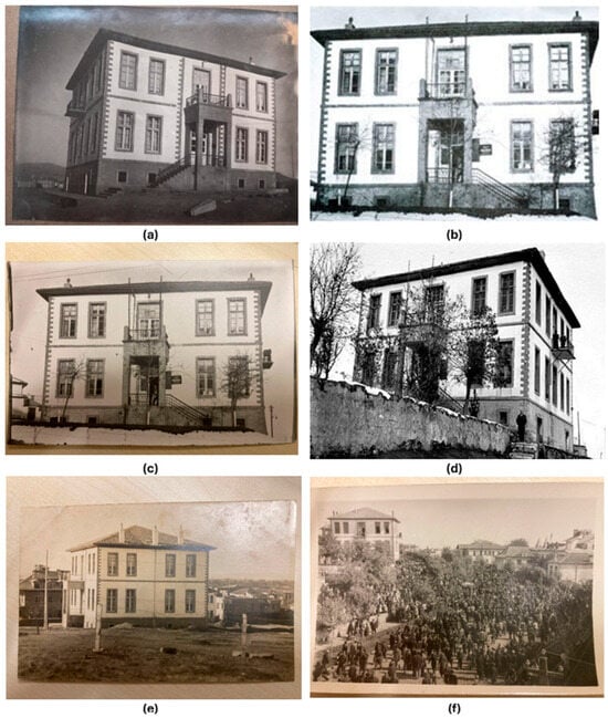
Figure 6.
(a) Konya Halkevi rear façade []. (b) Konya Halkevi front façade []. (c) Konya Halkevi right side façade []. (d) Konya Halkevi perspective view []. (e) Konya Halkevi right side façade []. (f) Konya Halkevi general view [].
The primary reason for selecting the Konya People’s House as a case study in this research is that it represents an example of architectural heritage that no longer exists. While literature reviews reveal historical narratives and analyses related to the building, the majority of these studies focus on its educational functions or the architectural features of the later structures constructed afterward [,,].
Consequently, no comprehensive document reflecting the original plan layout or precise measurements of the building could be located.
As a result of extensive archival research, a drawing believed to depict the basement floor plan was identified; this plan was redrawn digitally using AutoCAD 2023 software and incorporated into the analysis (Figure 7). A comparison of the plan with archival photographs revealed that the building featured two separate entrances accessible via independent staircases. However, the spatial functions described in the literature (such as the library, concert hall, administrative offices, etc.) did not correspond precisely with the measurements indicated in the plan, raising questions about its accuracy.
To obtain more definitive plan drawings of the building, extensive searches were conducted in the Ottoman Archives and the Republican Archives of the Prime Ministry; however, no concrete and reliable documents were found. Therefore, the building plan was reconstructed based on the limited available photographs and written records. Window openings and their relative distances were analyzed using the raster image function in the AutoCAD environment, while door openings were determined by referencing similar contemporary public buildings and incorporated into the model.
The digital modeling process continued by transferring the completed drawings, developed in AutoCAD using data from photographs and literature, into the Revit 2023 software (Figure 8). The modeling in Revit was designed to reflect the spatial layout and architectural features of the building as accurately as possible within the constraints of the available data.
The inability to access original architectural drawings and the fact that the structure was demolished long ago lend a unique value to the reconstruction process presented in this study []. Digitally reviving the Konya People’s House—one of the first People’s Houses built in Anatolia as part of the Republic’s educational reforms—not only strengthens its place in architectural memory but also contributes to transmitting its cultural significance to future generations.
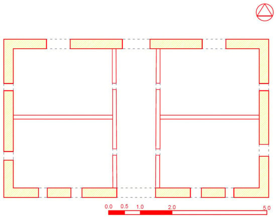
Figure 7.
Basement floor plan scheme of the Konya People’s House as documented in the literature [] and its digital drawing created in AutoCAD.

Figure 8.
Plan schemes created in Revit 2023 based on archival photographs and historical documents of the Konya People’s House.
4. Methodology
The virtual reconstruction process of the Konya People’s House required a multi-stage methodological approach shaped by various constraints. The primary challenge was the building’s complete loss, which meant that no physical data could be obtained through conventional digital scanning techniques. Furthermore, the absence of architectural plans, sectional drawings, or technical documents related to the structure in the existing literature further complicated the reconstruction efforts.
In this context, the first stage involved an extensive review of official institutional archives, historical sources pertaining to the relevant period, scholarly publications, and visual materials from private collections. The photographs from the Hasan Çopur archive presented in the table in Figure 6 were entrusted to the authors by the collector prior to his passing, with the intention that they be used for documentation and archival studies, and to serve as a basis for this research. These materials have made a significant contribution to the study. Based on the limited data gathered, two-dimensional plan drawings of the building were recreated using Autodesk AutoCAD 2023 software and subsequently transferred to the Revit 2023 platform. Within the Revit environment, the building was modeled three-dimensionally by referencing historical photographs and material data derived from comparable structures built in the same period. Since no original information on façade cladding was available, a material typology was proposed based on the analysis of similar public buildings constructed in the same region and era (Figure 9).
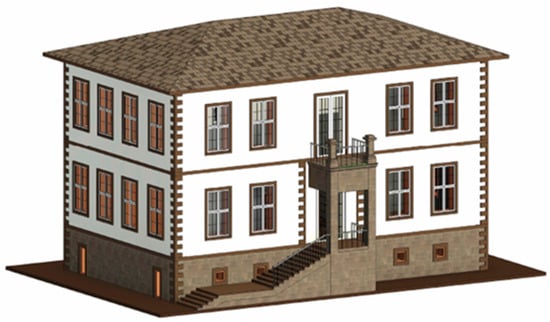
Figure 9.
Digital reconstruction model of the Konya People’s House developed using Revit 2023 software.
To make the three-dimensional model accessible within an augmented reality (AR) environment, software solutions compatible with local conditions in Türkiye were evaluated to enhance user accessibility. In this regard, integration tests were conducted using two different AR applications: Augmentecture, a plug-in specifically developed for Revit, and ARki, a mobile platform application. Additionally, a customized AR application was developed using Unity 3D 2021.3.36f1 (LTS) software, and its performance was analyzed comparatively.
The selected example of the Konya People’s House served as a prototype for the proposed augmented reality method, demonstrating that the approach could be applied to other lost architectural heritage structures of different scales and typologies that also suffer from limited archival data.
Through these tools, the generated model was experienced across multiple platforms, and the results were evaluated through comparative analysis. The entire workflow was structured into four main stages: archival research, creation of two-dimensional technical drawings, three-dimensional digital modeling, and integration with augmented reality applications. The table below (Figure 10) summarizes the key components of this process along with the digital tools utilized.
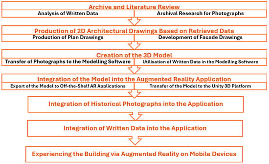
Figure 10.
Methodological workflow diagram for the virtual reconstruction process of the Konya People’s House.
The model was validated by systematically cross-checking the reconstructed elements with available archival photographs, written records, and secondary architectural sources. Particular attention was given to façade proportions, window placements, and spatial arrangements. While no original architectural drawings survived, triangulating these resources ensured visual and contextual consistency. This validation process reduced subjectivity and enhanced the reliability of the reconstruction despite inevitable interpretative elements.
The AR platforms used in this study were chosen based on four criteria: accessibility (requiring no coding knowledge), user-friendliness for non-technical researchers, mobile compatibility for broader accessibility, and performance in terms of stability, interactivity, and environmental integration. These parameters were considered essential to ensure that the methodology could be replicated by researchers in art history and architecture without advanced technical skills. Accordingly, three platforms (ARki, Augmentecture, and Unity + Vuforia) were evaluated to provide a comparative perspective.
5. Findings
5.1. Augmented Reality Testing with the Augmentecture Application
The first stage of testing involved the Augmentecture plug-in, which offers direct integration with Revit. The application provided relatively straightforward access, allowing the digital model to be elevated onto a printed plan through marker-based alignment. In practice, once limiting markers were added to the footprint, the model aligned more stably with the plan lines and remained attached even when the printed sheet was moved (Figure 11 and Figure 12).
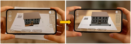
Figure 11.
Elevation of the Konya People’s House on the printed base sheet via the Augmentecture application, aligned with the drawing lines using limiting markers. (QR code for in-app visualization only.)
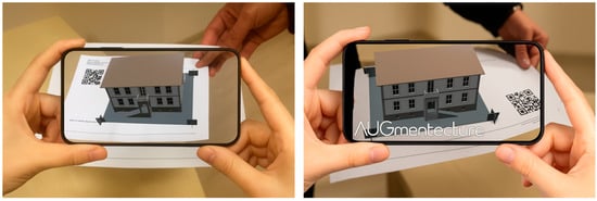
Figure 12.
AR view of the Konya People’s House via the Augmentecture application while the printed base sheet is being moved. (QR code for in-app visualization only.)
Despite these advantages, the platform exhibited some limitations. Its reliance on physical markers restricted scalability and introduced sensitivity to positional errors. Moreover, Augmentecture was constrained to Revit’s environment and offered no dedicated data integration beyond basic visualization. These factors limited its use for larger heritage projects, though its ease of setup made it suitable for rapid prototyping. A summary of its evaluation is presented in Table 1.

Table 1.
Evaluation of the Augmentecture application according to architectural heritage documentation criteria.
5.2. Augmented Reality Testing with the ARki Application
The second platform tested was ARki, which supports FBX file formats compatible with multiple modeling tools. This allowed greater flexibility compared to Augmentecture, and the model could be projected directly over a plan sheet in mobile environments. During tests, the model aligned accurately with plan lines and textures were preserved, ensuring a realistic impression of material assignments (Figure 13).
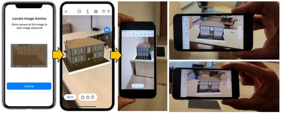
Figure 13.
Process of adding the site plan image and running the model in the ARki application via a mobile device in the augmented reality environment.
However, the platform required a more complex setup process, including multi-stage preparation of base files, which reduced its accessibility for non-technical users. Additionally, when the printed plan was moved, the digital model followed with a noticeable delay. While this issue did not significantly distort the plan-based alignment, it affected user interaction fluidity. The overall evaluation, highlighting its strengths in file compatibility but limitations in performance, is summarized in Table 2.

Table 2.
Evaluation of the ARki application according to architectural heritage documentation criteria.
5.3. Testing the Newly Developed Augmented Reality Application
In the final stage, a custom Unity + Vuforia-based application was developed to address the shortcomings observed in the commercial tools. Unlike the previous platforms, this prototype eliminated the need for physical markers and supported the integration of multiple content layers, including textual and visual annotations. This capability provided an enriched user experience and extended the application beyond basic visualization.
Testing revealed that the prototype achieved stable alignment under varying lighting conditions and moved synchronously with the printed plan. The application also demonstrated faster and more consistent behavior than the commercial tools, providing smoother interaction and greater reliability for heritage documentation (Figure 14 and Figure 15).
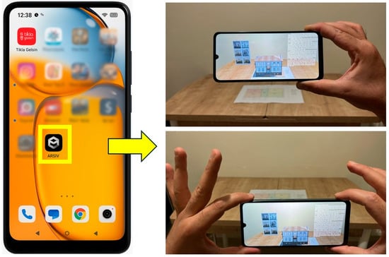
Figure 14.
Testing of the new AR application (Arsiv) on an Android mobile device.

Figure 15.
Demonstration of the developed AR application both when the reference plan is static and when it is moved across the surface.
While the Unity + Vuforia system required more technical expertise to configure, it offered advanced data integration and superior synchronization, making it more suitable for projects where comprehensive documentation and public presentation are critical. Its comparative advantages are summarized in Table 3.

Table 3.
Evaluation of the developed AR application based on architectural heritage documentation criteria.
Across the three approaches, the findings highlight that plan-coherent registration, stability during motion, and capacity for data-layer integration are decisive criteria in AR-based heritage documentation. The custom Unity + Vuforia application outperformed the commercial tools particularly in synchronization and content integration, demonstrating its potential as a more robust and inclusive solution.
Beyond the technical performance, user experience emerged as a decisive factor in evaluating the tested AR platforms. While Augmentecture provided a straightforward entry point with minimal setup, its marker dependency limited flexibility for broader applications. Conversely, ARki enabled richer visualization but required multiple preparation steps, thereby reducing accessibility for non-technical users. The developed Unity + Vuforia prototype, despite its more demanding configuration process, offered smoother interactions and greater consistency, ultimately enhancing usability and interpretability for both experts and general audiences.
Particular attention must be drawn to the accessibility challenges of ARki, which restrict its adoption among researchers and institutions lacking advanced technical skills. In contrast, the proposed workflow, designed to minimize coding requirements while ensuring stability, provides a more inclusive framework. Furthermore, the Unity + Vuforia application demonstrated potential for long-term sustainability by enabling flexible integration of content layers and supporting reuse across different heritage sites. This adaptability highlights its value not only as a visualization tool but also as a sustainable method for digital archiving and heritage preservation.
To synthesize the comparative results, a radar chart was generated to visualize the relative strengths and weaknesses of the three AR applications across multiple criteria (Figure 16). As illustrated, the Unity + Vuforia prototype demonstrated superior performance in plan alignment, stability, and data integration, whereas Augmentecture excelled in setup simplicity and accessibility. ARki offered intermediate results with notable flexibility in platform compatibility but limitations in stability. This comparative visualization reinforces the argument that while commercial tools remain valuable for rapid deployment, the proposed prototype provides a more sustainable and comprehensive solution for architectural heritage documentation.
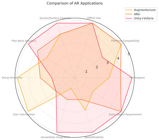
Figure 16.
A radar chart developed to illustrate the relative strengths and weaknesses of the three AR applications (Augmentecture, ARki, and Unity + Vuforia) across multiple evaluation criteria, serving as a synthesis of the comparative results.
It should be noted that the radar chart does not represent absolute quantitative measurements but rather a comparative visualization derived from the qualitative evaluations summarized in Table 1, Table 2 and Table 3. The 1–5 scale was applied following observational analysis and expert judgment, in line with common practices in usability and technology assessment studies [,]. This approach allowed qualitative findings to be translated into a standardized comparative format, providing a clearer overview of relative strengths and weaknesses. However, the results remain inherently interpretative and may vary across different user groups, reflecting the methodological limitation of expert- and observation-based scoring.
6. Evaluation
This study examines the potential use of augmented reality (AR) technology for the digital documentation and visualization of lost architectural heritage, comparing the performance of Augmentecture, ARki, and a custom-developed Unity + Vuforia-based application (Table 4).

Table 4.
Comparative assessment of the tested AR applications according to architectural heritage documentation criteria.
Each application demonstrated distinct characteristics in terms of user interaction level, technical complexity, and content integration capacity. The Augmentecture platform, which operates as a Revit plug-in, offers users a straightforward installation and basic integration process. However, while its visualization accuracy based on plan overlays is moderate, its support for dynamic content integration is limited, and it requires additional physical markers for spatial alignment.
In contrast, ARki stands out with its broad cross-platform file format support, enabling integration with various software such as 3ds Max and Google Drive. However, this advantage requires a multi-layered setup process (Figure 17), which can result in time delays and performance issues during model tracking, with limited support for integrating local multimedia content.
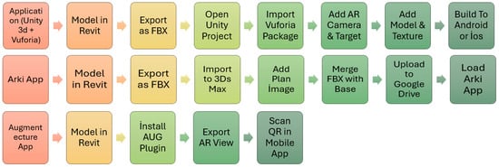
Figure 17.
Comparative schematic representation of the setup processes for the tested AR applications.
Despite its technically more complex configuration, the custom-developed Unity + Vuforia application provides a comprehensive set of features that enable the projection of both static and dynamic content (e.g., images, text, videos) in real time onto a physical plan base. Moreover, this system demonstrated high levels of synchronization and stability even under varying lighting conditions and in mobile scenarios.
In conclusion, while Augmentecture [] and ARki [] offer practical solutions for rapid prototyping and basic-level AR visualization needs, the Unity + Vuforia-based system presents a more advanced and holistic approach for the documentation, archiving, and digital presentation of lost architectural heritage [].
Previous research has highlighted the potential of AR in reconstructing lost architectural heritage [,,,,,,,,,]. Building on this body of work, the present study extends the discussion by demonstrating how AR can be applied in the case of the Konya People’s House.
Recent bibliometric reviews also underline that AR in cultural heritage is predominantly applied in areas such as 3D reconstruction, digital heritage, virtual museums, tourism, and gamification, confirming the relevance of our case study within broader research trends [].
Consistent with our findings on the superiority of synchronization in mixed-content overlays, it was demonstrated that multi-user MR systems must maintain real-time positional correspondence among participants to ensure immersive and collaborative heritage exploration []. Similarly, our Unity + Vuforia prototype’s stable, synchronous tracking represents a critical advantage over marker-dependent tools in fostering synchronized AR experiences.
Our approach’s layered integration of visual and textual annotations echoes the multidimensional design of location-based AR applications that combine GPS-triggered content with immersive virtual tours to enrich cultural heritage education []. The similarity underscores the importance of multi-layered data in promoting heritage comprehension and engagement. It was highlighted that AR-GIS hybrid systems can articulate detailed construction features in a heritage context—specifically, bridging on-site artifacts with georeferenced overlays to reveal engineering techniques []. In a complementary manner, our case of digitally reviving the Konya People’s House through AR also emphasizes AR’s role in reconstructing lost architectural identity, even in absence of original documentation. In line with previous AR application evaluations, Augmentecture and ARki were comparatively tested within this study. Augmentecture, integrated with Revit, is notable for its easy setup and basic visualization, whereas ARki, despite broader compatibility, poses installation complexity and occasional performance limitations. These findings highlight the added value of the Unity + Vuforia-based application, which provides static and dynamic content placement directly on the plan base, thereby offering a more advanced environment for digital presentation and interaction.
Studies exploring AR integrated with wearable hardware (e.g., HoloLens) for preserving and transmitting historical street layouts found that immersive wearable environments markedly enhance user interaction and heritage perception []. While our prototype operates on mobile devices, the shared benefit lies in fostering intuitive heritage engagement beyond traditional visualizations. Similar wearable AR implementations, such as the Kapanca Street project in Türkiye, demonstrated how immersive devices can strengthen both documentation and user engagement, suggesting a strong parallel with our mobile-based approach []. Consistent with prior findings that emphasize the role of mobile AR in cultural heritage dissemination [], our results demonstrate the feasibility of applying such tools in the case of the Konya People’s House.
Moreover, recent studies revealed that AR attributes such as interactivity, vividness, and novelty significantly foster perceived usefulness and enjoyment, which in turn encourage heritage-responsibility behaviors among visitors [].
However, the performance differences observed among the applications are currently limited to qualitative evaluations. Future studies should support technical parameters such as processing time, device resource usage, render quality, and user interaction duration with quantitative data []. Such metrics will enable the developed method to be compared with similar platforms more objectively. A review of Table 4 indicates that the custom Unity + Vuforia solution particularly excels in “Visual/Data Integration”, “Plan Base Alignment”, “Speed/Stability”, and its ability to function without any additional physical objects or markers. This demonstrates that the developed system is not only capable of presenting 3D models but can also synchronize multiple layers of data—such as text, images, and videos—within the AR environment. Furthermore, its capacity to operate fully aligned with the physical plan base, without requiring external markers, is considered a significant advantage for the documentation and public presentation of lost architectural heritage.
The Augmentecture platform performs well in criteria such as “Ease of Use”, “Simple Setup”, and “Mobile Compatibility”, offering a practical solution for basic AR experiences based on plan overlays. However, its limited data integration and reliance on marker-based operation suggest that this platform is more suitable for rapid prototyping scenarios and projects with lower content complexity. The radar chart further highlights that, despite its user-friendly structure, it may fall short for projects requiring high data density.
On the other hand, ARki offers clear advantages in “File Compatibility” and “Multi-Software Support”, allowing integration with a wide range of modeling tools. Nonetheless, its multi-layered setup process and user-dependent steps introduce certain challenges during use. The radar analysis clearly reflects this situation in areas where high user interaction is needed but functionality remains relatively limited.
Overall, the comparative evaluation of the three applications illustrates that they differ not only in functionality but also in terms of sustainability, data integration capacity, and user accessibility. The findings demonstrate that the Unity + Vuforia-based system provides a more comprehensive and flexible solution for the documentation and digital dissemination of architectural heritage. This finding resonates with the broader discourse on heritage smart cities, where digital twins, AI, and immersive technologies are increasingly seen as critical tools for balancing preservation, accessibility, and sustainable cultural tourism []. Moreover, comparable museum-based AR initiatives have also shown that interactive digital layers not only enhance visitor engagement but also facilitate the understanding of abstract cultural or scientific concepts, underscoring the pedagogical potential of AR in heritage contexts [].
7. Discussion and Limitations
Within the scope of this study, the Augmentecture and ARki applications were tested and found to have parallels with various examples in the existing literature focusing on the documentation of cultural heritage through augmented reality (e.g., [,,,,,,,,]). However, it was observed that both applications have certain limitations in terms of model elevation on plan bases and data integration processes. In particular, although Augmentecture proves effective for rapid prototyping thanks to its simple Revit-compatible installation, it remains insufficient for large-scale projects due to its limited content integration capacity and dependence on marker-based alignment. Meanwhile, the ARki application offers advantages in terms of file format compatibility, yet its multi-layered setup process and occasional delays in plan alignment may lead to performance issues that negatively affect the user experience.
In this context, the Unity + Vuforia-based custom AR application, similar to the virtual reconstructions of lost buildings demonstrated by Günay (2022) [] and Dewitz et al. (2019) [], provides visualization possibilities based on limited archival data. Its distinctive contribution, however, lies in minimizing the need for technical support from other disciplines, thereby enabling local stakeholders to actively participate in the process. Consequently, the findings reveal that AR technology can evolve beyond being merely a visualization tool into a user-friendly approach for documentation and digital preservation [].
The original contribution of this study is that, while aligned with the examples of virtual reconstructions of lost architectural heritage in the literature, it proposes an open-source, easily applicable AR prototype that does not require advanced software skills. This makes it accessible to local authorities, collectors, and independent users from different fields, adaptable across diverse cultural and spatial contexts. In this way, the study suggests a more inclusive framework for sustainable digital preservation and cultural transmission.
The primary limitation of this study is that the testing phase was conducted with a limited number of devices and user profiles. Furthermore, the performance assessments were restricted to qualitative observations; parameters such as processing time, render quality, and user interaction time were not supported by quantitative data. Future research should include comprehensive experimental studies with various hardware and software combinations to objectively demonstrate the broader applicability of the proposed method. Accordingly, it is recommended that upcoming studies conduct user tests, measure processing times, and analyze interaction data statistically.
As no original architectural drawings or precise measurements of the Konya People’s House have survived, certain aspects of the reconstruction (e.g., façade proportions, interior arrangements) inevitably involved interpretative decisions based on available photographs and written descriptions. This subjectivity represents a limitation of the study.
Future research should prioritize experimental designs that incorporate quantitative measures such as processing time, rendering quality, and user interaction metrics, tested across diverse hardware and software environments. Conducting usability studies with both expert and non-expert participants would provide a more representative understanding of the applicability of AR in heritage documentation. Beyond methodological development, the findings of this study also carry long-term policy and educational implications. Integrating accessible AR tools into heritage conservation strategies can promote sustainable digital preservation practices, while embedding AR-based documentation methods into architectural and art history curricula can strengthen the training of future professionals. These directions highlight the dual role of AR technologies as both practical tools and transformative instruments for cultural heritage management.
8. Conclusions
The primary aim of this study is to evaluate user-friendly augmented reality (AR) applications that can contribute to the documentation and archiving of architectural heritage. Considering that researchers and practitioners in fields such as architecture and art history often lack direct integration with technology or advanced software skills, the need for accessible digital tools in this context becomes increasingly evident. Accordingly, this study investigates whether the AR applications examined can support the digital documentation of architectural heritage without requiring programming knowledge or advanced technical assistance.
The applications evaluated were selected with the technical proficiency levels of potential users in mind—particularly collectors, architects, and art historians who are engaged in the production of documentation for the preservation of cultural heritage. This approach aims to enable users with access to technological tools, but with limited capacity for advanced customization, to actively participate in digital documentation processes.
Within the scope of this study, two accessible AR applications were tested for the reconstruction and interactive experience of architectural heritage. Based on identified challenges, a new Unity + Vuforia-based prototype was developed and demonstrated to offer a more advanced environment for digital presentation and interaction.
These applications were technically compared based on aspects such as model elevation on plan drawings, data integration, installation complexity, user-friendliness, and mobile device performance. The findings indicate that the Unity + Vuforia system offers a more holistic and inclusive tool for documenting cultural heritage structures and communicating them to wider audiences through new-generation presentation techniques. In this context, the study demonstrates that mobile AR technologies can serve not only as visualization tools but also as versatile platforms for digital preservation, education, and cultural transmission.
The findings suggest that the proposed method holds potential applicability not only for lost buildings with limited archival data such as the Konya Halkevi but also for cultural heritage sites of different scales and typologies. Moreover, local authorities, museums, and independent collectors can use such accessible AR solutions to conduct documentation processes without the need for technical support from other disciplines, thus contributing to the intergenerational transmission of these structures.
In conclusion, this study aligns with the literature on the virtual reconstruction of lost architectural heritage. Its distinctive contribution lies in reducing the need for cross-disciplinary expertise, thereby enabling local actors to participate more actively in digital documentation processes.
Nonetheless, conducting the study on a single case structure with a limited user profile presents a constraint regarding the generalizability of the findings. Furthermore, since testing was carried out only on specific mobile devices and environments, variations in performance may arise on different hardware and software infrastructures. Therefore, the adaptability of the proposed model to architectural heritage sites of various scales should be validated in future studies with broader examples.
While this study primarily relied on qualitative observations, it is recommended that future research include quantitative measurements of metrics such as processing times, data integration speed, and processor/mobile device resource usage. Such measurements will help demonstrate the performance advantages of the developed AR infrastructure more concretely.
Future studies should design test scenarios involving structures of varying scales and typologies, including wider user groups, to assess the effectiveness of the proposed methods in sustainable preservation and cultural transmission processes more comprehensively. Accordingly, the proposed model can serve not only as a reference point for academic research but also as a practical resource for local government projects and museum applications.
This study contributes to the field not only by demonstrating the feasibility of AR for architectural heritage documentation, but also by introducing a simplified and more accessible workflow. Unlike existing approaches that often require advanced coding or specialized technical expertise, the proposed Unity + Vuforia-based prototype was designed to be adaptable for non-technical researchers and cultural heritage practitioners. This novelty ensures that digital preservation and communication of lost or endangered buildings can be achieved more inclusively and sustainably. Practically, the workflow enables scholars, educators, and institutions to integrate AR into documentation and educational practices with minimal barriers, offering a replicable model that can support both academic research and long-term heritage conservation strategies.
Author Contributions
O.Z.Y.: Conceptualization, methodology, software development, formal analysis, inquiry, data curation, original draft composition, visualization. A.E.B.E.: Conceptualization, validation, writing—review and editing, oversight. All authors have read and agreed to the published version of the manuscript.
Funding
This research received no external funding.
Data Availability Statement
Additional questions can be forwarded to the corresponding author; the article contains the original contributions made throughout the study.
Acknowledgments
This study was prepared by Osman Zİyaettin Yağcı within the scope of his doctoral thesis prepared at Karabük University Graduate Education Institute under the supervision of Ayşen Esra Bölükbaşı Ertürk.
Conflicts of Interest
The authors declare no conflicts of interest.
References
- Casini, M. Extended reality for smart building operation and maintenance: A review. Energies 2022, 15, 3785. [Google Scholar] [CrossRef]
- Kuban, D. Tarihi Çevre Korumanın Mimarlık Boyutu: Kuram ve Uygulama, 1st ed.; Yapı-Endüstri Merkezi Yayınları: İstanbul, Türkiye, 2000. [Google Scholar]
- D’Ayala, D.; Smars, P. Minimum Requirement for Metric Use of Non-Metric Photographic Documentation; University of Bath Report: Bath, UK, 2003. [Google Scholar]
- Bevilacqua, M.G.; Caroti, G.; Piemonte, A.; Ulivieri, D. Reconstruction of lost architectural volumes by integration of photogrammetry from archive imagery with 3D models of the status quo. Int. Arch. Photogramm. Remote Sens. Spat. Inf. Sci. 2019, 42, 119–125. [Google Scholar] [CrossRef]
- Günay, S. Virtual Reality for Lost Architectural Heritage Visualization Utilizing Limited Data. Int. Arch. Photogramm. Int. Arch. Photogramm. Remote Sens. Spat. Inf. Sci. 2022, 46, 253–257. [Google Scholar] [CrossRef]
- Kidik, A.; Asiliskender, B. Augmented Reality Technologies İn Architectural Design Education: A Systematic Literature Review. Proc. CBU Soc. Sci. 2024, 4, 7–12. [Google Scholar]
- Marino, E.; Barbieri, L.; Colacino, B.; Fleri, A.K.; Bruno, F. An Augmented Reality İnspection Tool to Support Workers in Industry 4.0 Environments. Comput. İnd. 2021, 127, 103412. [Google Scholar] [CrossRef]
- Pietroni, E.; Ferdani, D. Virtual Restoration and Virtual Reconstruction in Cultural Heritage: Terminology, Methodologies, Visual Representation Techniques and cognitive Models. Information 2021, 12, 167. [Google Scholar] [CrossRef]
- Catal, C.; Akbulut, A.; Tunali, B.; Ulug, E.; Ozturk, E. Evaluation of augmented reality technology for the design of an evacuation training game. Virtual Real. 2020, 24, 359–368. [Google Scholar] [CrossRef]
- Balletti, C.; Dabrowski, M.; Guerra, F.; Vernier, P. Digital reconstruction of a lost heritage: The San Geminiano’s church in San Marco’s Square in Venice. In Proceedings of the IMEKO TC-4 International Conference on Metrology for Archeology and Cultural Heritage, Trento, Italy, 22–24 October 2020; pp. 22–24. [Google Scholar]
- Paes, D.; Feng, Z.; King, M.; Shad, H.K.; Sasikumar, P.; Pujoni, D.; Lovreglio, R. Optical see-through augmented reality fire safety training for building occupants. Autom. Constr. 2024, 162, 105371. [Google Scholar] [CrossRef]
- Mackinlay, J.; Shneiderman, B. (Eds.) Readings in Information Visualization: Using Vision to Think; Morgan Kaufmann: San Francisco, CA, USA, 1999. [Google Scholar]
- Dewitz, L.; Kröber, C.; Messemer, H.; Maiwald, F.; Münster, S.; Bruschke, J.; Niebling, F. Historical photos and visualizations: Potential for research. Int. Arch. Photogramm. Remote Sens. Spat. Inf. Sci. 2019, 42, 405–412. [Google Scholar] [CrossRef]
- Mourtzis, D.; Zogopoulos, V.; Katagis, I.; Lagios, P. Augmented reality based visualization of CAM instructions towards Industry 4.0 paradigm: A CNC bending machine case study. Procedia CIRP 2018, 70, 368–373. [Google Scholar] [CrossRef]
- Lovreglio, R.; Kinateder, M. Augmented reality for pedestrian evacuation research: Promises and limitations. Saf. Sci. 2020, 128, 104750. [Google Scholar] [CrossRef]
- Moro, C.; Štromberga, Z.; Raikos, A.; Stirling, A. The effectiveness of virtual and augmented reality in health sciences and medical anatomy. Anat. Sci. Educ. 2017, 10, 549–559. [Google Scholar] [CrossRef] [PubMed]
- Dörk, M. Towards a Better VIEW: Visual Information Exploration on the Web. Ph.D. Thesis, Otto-von-Guericke-University Magdeburg, Magdeburg, Germany, 2008. [Google Scholar]
- Goldfarb, D.; Arends, M.; Froschauer, J.; Merkl, D. Revisiting 3D information landscapes for the display of art historical web content. In Proceedings of the 8th International Conference on Advances in Computer Entertainment Technology, Lisbon, Portugal, 8–11 November 2011; pp. 1–8. [Google Scholar] [CrossRef]
- Khan, M.; Khan, S.S. Data and information visualization methods, and interactive mechanisms: A survey. Int. J. Comput. Appl. 2011, 34, 1–14. [Google Scholar]
- Rokhsaritalemi, S.; Sadeghi-Niaraki, A.; Choi, S.M. A review on mixed reality: Current trends, challenges and prospects. Appl. Sci. 2020, 10, 636. [Google Scholar] [CrossRef]
- Gladstone, H.B.; Raugi, G.J.; Berg, D.; Berkley, J.; Weghorst, S.; Ganter, M. Virtual reality for dermatologic surgery: Virtually a reality in the 21st century. J. Am. Acad. Dermatol. 2000, 42, 106–112. [Google Scholar] [CrossRef]
- Windhager, F.; Federico, P.; Schreder, G.; Glinka, K.; Dörk, M.; Miksch, S.; Mayr, E. Visualization of cultural heritage collection data: State of the art and future challenges. IEEE Trans. Vis. Comput. Graph. 2019, 25, 2311–2330. [Google Scholar] [CrossRef] [PubMed]
- Fornes, I.D.L.T.; Maruenda, J.C.; González, D.M. Knowing the architectural heritage through graphic survey: The castle of Ademuz. Disegnarecon 2023, 16, 26. [Google Scholar] [CrossRef]
- Anay, H.; Özten, Ü.; Ünal, M.; Öztepe, E. Augmented reality for the presentation of cultural heritage: On-site application and evaluation of a model. ICONARP Int. J. Archit. Plan. 2023, 11, 323–345. [Google Scholar] [CrossRef]
- Banfi, F.; Brumana, R.; Roascio, S.; Previtali, M.; Roncoroni, F.; Mandelli, A.; Stanga, C. 3D heritage reconstruction and Scan-to-HBIM-to-XR project of the tomb of Caecilia Metella and Caetani Castle, Rome, Italy. Int. Archit. Photogramm. Remote Sens. Spat. Inf. Sci. 2022, 46, 49–56. [Google Scholar] [CrossRef]
- Cannella, M. AR methods for the visualization of the lost marble “Tribuna” in the main apse of the cathedral of Palermo. Int. Arch. Photogramm. Remote Sens. Spat. Inf. Sci. 2022, 46, 129–134. [Google Scholar] [CrossRef]
- Spallone, R.; Lamberti, F.; Olivieri, L.M.; Ronco, F.; Lombardi, L. Augmented Reality and Avatars for Museum Heritage Storytelling. In Beyond Digital Representation. Digital Innovations in Architecture, Engineering and Construction; Giordano, A., Russo, M., Spallone, R., Eds.; Springer Nature Switzerland AG: Cham, Switzerland, 2024; pp. 241–258. [Google Scholar] [CrossRef]
- Cosco, F.; Garre, C.; Bruno, F.; Muzzupappa, M.; Otaduy, M.A. Visuo-haptic mixed reality with unobstructed tool-hand integration. IEEE Trans. Vis. Comput. Graph. 2013, 19, 159–172. [Google Scholar] [CrossRef]
- Kaynar, O. Konya Halkevi’nin Türk Modernleşmesindeki Faaliyetleri (1932–1951). Master’s Thesis, Dumlupınar Üniversitesi Sosyal Bilimler Enstitüsü, Kütahya, Turkey, 2007. [Google Scholar]
- Akhan, N.E.; Yılmaz, D.; Akhan, N.E.S. İlk dönem halkevlerinin eğitim faaliyetleri “Konya Halkevi örneği”. Karadeniz Araştırmaları 2011, 29, 59–95. [Google Scholar]
- Parlak, Ö.; Yaldız, E. Konya Devlet Tiyatrosu (Halkevi) binasının modern mimarlık mirası kapsamında değerlendirilmesi. Türk İslam Medeni. Akad. Araştırmalar Derg. 2022, 17, 223–252. [Google Scholar] [CrossRef]
- Çopur, H. (Collector, Konya, Turkey). Personal communication, 2020.
- Mohammadrezaei, E.; Ghasemi, S.; Dongre, P.; Gračanin, D.; Zhang, H. Systematic review of extended reality for smart built environments lighting design simulations. IEEE Access 2024, 12, 17058–17089. [Google Scholar] [CrossRef]
- Yıldırım, M. Konya’da Kaybolan Türk İslam Eserleri, 1st ed.; Palet Yayınları: Konya, Türkiye, 2015; pp. 155–157. [Google Scholar]
- Huang, H.; Siraj, S. Quantifying and reducing the complexity of multi-line charts as a visual aid in multi-criteria decision-making. Ann. Oper. Res. 2024, 2024, 1–26. [Google Scholar] [CrossRef]
- Peng, W.; Li, Y.; Fang, Y.; Wu, Y.; Li, Q. Radar chart for estimation performance evaluation. IEEE Access 2019, 7, 113880–113888. [Google Scholar] [CrossRef]
- Augmentecture. Available online: https://www.augmentecture.com (accessed on 25 July 2023).
- ARki. Available online: https://www.darfdesign.com/arki (accessed on 20 August 2023).
- Yigitbas, E.; Nowosad, A.; Engels, G. Supporting construction and architectural visualization through BIM and AR/VR: A systematic literature review. In Proceedings of the IFIP Conference on Human-Computer Interaction, Cham, Switzerland, 25–29 August 2023; Springer Nature: Cham, Switzerland, 2023; pp. 145–166. [Google Scholar]
- Liu, Z.; He, Y.; Demian, P.; Osmani, M. Immersive technology and building information modeling (BIM) for sustainable smart cities. Buildings 2024, 14, 1765. [Google Scholar] [CrossRef]
- Boboc, R.G.; Băutu, E.; Gîrbacia, F.; Popovici, N.; Popovici, D.M. Augmented reality in cultural heritage: An overview of the last decade of applications. Appl. Sci. 2022, 12, 9859. [Google Scholar] [CrossRef]
- Chrysanthakopoulou, A.; Chrysikopoulos, T.; Arvanitis, G.; Moustakas, K. Reimagining Historical Exploration: Multi-User Mixed Reality Systems for Cultural Heritage Sites. Appl. Sci. 2025, 15, 2854. [Google Scholar] [CrossRef]
- Kleftodimos, A.; Evagelou, A.; Triantafyllidou, A.; Grigoriou, M.; Lappas, G. Location-based augmented reality for cultural heritage communication and education: The Doltso district application. Sensors 2023, 23, 4963. [Google Scholar] [CrossRef] [PubMed]
- Shih, N.J.; Wu, Y.C. Augmented reality-and geographic information system-based inspection of brick details in heritage warehouses. Appl. Sci. 2024, 14, 8316. [Google Scholar] [CrossRef]
- Bekele, M.K.; Champion, E.; McMeekin, D.A.; Rahaman, H. The influence of collaborative and multi-modal mixed reality: Cultural learning in virtual heritage. Multimodal Technol. Interact. 2021, 5, 79. [Google Scholar] [CrossRef]
- Ibiş, A.; Çakici Alp, N. Augmented reality and wearable technology for cultural heritage preservation. Sustainability 2024, 16, 4007. [Google Scholar] [CrossRef]
- Chen, S.; Tian, Y.; Pei, S. Technological use from the perspective of cultural heritage environment: Augmented reality technology and formation mechanism of heritage-responsibility behaviors of tourists. Sustainability 2024, 16, 8261. [Google Scholar] [CrossRef]
- Lucchi, E. Digital twins, artificial intelligence and immersive technologies for heritage preservation and cultural tourism in smart cities. In Digital Twin, Blockchain, and Sensor Networks in the Healthy and Mobile City; Elsevier: Amsterdam, The Netherlands, 2025; pp. 507–520. Available online: https://www.sciencedirect.com/science/article/abs/pii/B9780443341748000260 (accessed on 23 August 2025).
- Spadoni, E.; Porro, S.; Bordegoni, M.; Arosio, I.; Barbalini, L.; Carulli, M. Augmented reality to engage visitors of science museums through interactive experiences. Heritage 2022, 5, 1370–1394. [Google Scholar] [CrossRef]
Disclaimer/Publisher’s Note: The statements, opinions and data contained in all publications are solely those of the individual author(s) and contributor(s) and not of MDPI and/or the editor(s). MDPI and/or the editor(s) disclaim responsibility for any injury to people or property resulting from any ideas, methods, instructions or products referred to in the content. |
© 2025 by the authors. Licensee MDPI, Basel, Switzerland. This article is an open access article distributed under the terms and conditions of the Creative Commons Attribution (CC BY) license (https://creativecommons.org/licenses/by/4.0/).