Article

Intra-City Differentiation Patterns and Typological Governance Strategies for Urban Villages in Kunming: Empirical Evidence from 140 Case Studies

Faculty of Architecture and City Planning, Kunming University of Science and Technology, Chenggong District, Kunming 650500, China
*
Author to whom correspondence should be addressed.
Buildings 2025, 15(16), 2943; https://doi.org/10.3390/buildings15162943
Submission received: 3 July 2025 / Revised: 4 August 2025 / Accepted: 18 August 2025 / Published: 19 August 2025
(This article belongs to the Section Architectural Design, Urban Science, and Real Estate)

Abstract

Amid China’s push for new urbanization and refined urban governance, urban villages function as key transitional spaces in the process of rural–urban spatial restructuring. Their internal differentiation and typological governance approaches warrant systematic exploration. This study examines 140 urban villages located in the core and peripheral areas of Kunming as empirical cases. By innovatively integrating polycentric urban theory with spatial accessibility theory, we construct a dual-dimensional classification framework. Employing the Analytic Hierarchy Process (AHP), we develop a comprehensive evaluation system encompassing ecological, spatial, social, and economic dimensions. Our findings reveal the following: (1) Urban villages with different levels of accessibility within the same region tend to exhibit broadly similar characteristics across most evaluation dimensions. However, outlier cases demonstrate distinct development trajectories that transcend spatial constraints, driven by unique mechanisms underlying their atypical evolution. (2) Cross-regional comparisons highlight systematic disparities across several dimensions, most notably in ecological quality, spatial efficiency, and economic vitality. Based on spatial differentiation, we propose five governance models tailored to varied urban village types. The proposed typological governance framework provides a replicable methodology for addressing urban-rural transition challenges in diverse contexts. By emphasizing the spatial heterogeneity of informal settlements and advocating for place-specific strategies based on geographic endowments, this model enables policymakers to move beyond one-size-fits-all approaches. For Chinese cities, it offers a systematic toolkit to classify urban villages according to their regional roles and developmental potentials, informing tailored regeneration plans. Globally, the framework’s emphasis on context-sensitive typology and multidimensional evaluation can guide the upgrading of informal settlements in rapidly urbanizing regions, particularly where rural-urban interfaces face similar fragmentation pressures.

1. Introduction

1.1. Research Background

Since China’s economic reforms and opening-up in the late 20th century, urbanization has sped up dramatically, reaching 67.0% by the end of 2024. In the past, cities grew in an extensive way, focusing more on expanding land use than improving quality. This approach brought many urban problems. In 2013, the Central Urbanization Work Conference introduced the idea of “new-type urbanization”, marking a major shift. The focus moved from simply expanding cities to making better use of the urban areas that already exist.
In 2021, the National Standardization Development Outline [1] was issued, explicitly advocating the establishment of a refined urban management standards system. This signaled the formal transition of China’s urban development into the era of refined governance.
Against this backdrop, urban village regeneration has become a key component of high-quality urban development, particularly within the broader agenda of urban stock renewal. That same year, the Ministry of Housing and Urban-Rural Development released the Notice on Preventing Large-Scale Demolition and Construction in Urban Renewal Actions [2], which called for strict limits on large-scale demolition and new construction, while encouraging a more measured and steady approach to urban village regeneration. In 2023, the State Council issued the Guiding Opinions on Promoting Urban Village Regeneration in Super-large and Megacities [3], further clarifying the priorities for this new phase of regeneration: (1) defining the spatial scope of regeneration efforts, and (2) formulating implementation plans based on the principles of steady progress and prudent action.

1.2. Literature Review

Urban villages are a unique outcome of China’s urbanization and its dual-track land management system, with no exact counterpart in other countries. However, they do share some spatial features with international forms like urban fringe zones and informal settlements. The term “urban fringe zone,” first used by German geographer H. Louts, describes rural areas that have been absorbed into cities as they expand [4]. In 1968, J. Pryor gave a more detailed definition, calling the urban-rural fringe a transitional zone between the urban core and purely agricultural land, blending both urban and rural characteristics [5]. Informal settlements—often discussed in the context of urban informality [6]—typically refer to “shanty towns” or clusters of self-built housing that help ease housing shortages [7,8].
Contemporary international research on informal housing often focuses on policy-driven regeneration and governance strategies aimed at balancing economic development with social equity. Dennis Conway and others argue that governments have long neglected the shrinking land availability for low-income populations [9]. Roy and colleagues further critique existing renewal strategies, describing them as an “aestheticization of poverty” efforts that beautify informal spaces without meaningfully improving residents’ livelihoods, incomes, or political agency [10,11]. In the Global South, informal housing remains the predominant residential solution for low-income populations [12]. Extensive research on African informal settlements has demonstrated that rapid urban expansion, when coupled with deficient planning frameworks, systematically exacerbates socioeconomic and spatial disparities between informal settlements and formal urban zones [13]. Latin American case studies, particularly from Bogotá, reveal that social housing interventions can catalyze urban transformation processes in adjacent informal settlements [14]. Comparative Policy Analysis Reveals Divergent Governance Pathways in India and Brazil: India has progressively transitioned toward market-led redevelopment models as a pragmatic compromise, whereas Brazil’s favela upgrading programs explicitly prioritize urban integration through comprehensive spatial and social interventions [15]. Although China’s urban villages differ fundamentally in terms of their origins and development mechanisms, they exhibit similar spatial characteristics: physical segregation from surrounding urban areas, dense populations, and often disordered layouts. These parallels offer valuable comparative insights and practical references for informing urban village governance strategies in the Chinese context.
Academic research on urban villages in China began with Tian Li’s 1998 study on “villages within cities” [16]. It was not until the early 21st century that the term, chengzhongcun (urban villages), gained traction in academic discourse and media narratives, though a universally accepted academic definition has yet to be established. Wan Chengwei et al. categorized the evolution of research into four distinct phases: the initial “urban–rural segregation” phase (1998–2002), the thriving “urban–rural symbiosis” phase (2003–2007), the steady “urban–rural integration” phase (2008–2012), and the ongoing “urban–rural co-development” phase (2013–present). This trajectory reflects a scholarly shift from examining the origins of urban villages to acknowledging their functions, analyzing urban–rural dynamics, and ultimately exploring their roles in broader processes of urban and national transformation [17]. Research on urban villages now spans a wide range of themes, including formation mechanisms [18], challenges and policy responses [19,20,21], demolition and resettlement processes [22,23], governance models [24,25,26], and planning strategies [27,28,29], demonstrating a trend toward increasingly multidimensional and in-depth inquiry.
However, most current studies rely heavily on localized case analyses, with limited systematic comparative research at a broader scale [30,31]. While some comparative efforts do exist, they often involve uncontrolled horizontal comparisons between domestic and international cases, typically listing characteristics without establishing hierarchical variable structures or accounting for contextual differences. In fact, intra-city conditions shaped by resource endowments, institutional factors, and historical development trajectories serve as the most critical background variables for distinguishing between different types of urban villages [32]. As such, controlled intra-city comparisons hold significant theoretical and practical value for identifying urban village typologies and informing more targeted and effective governance strategies.
This study addresses three key research questions:
  • What are the significant differences among urban villages with varying geographic locational endowments within the same city?
  • What are the core characteristics of urban villages with different geographic locational endowments?
  • How should urban villages be governed differently according to their intra-city variations?

2. Materials and Methods

2.1. Research Area

This study focuses on Guandu District and Anning City in Kunming as comparative case areas (Figure 1). Both serve as key components of Kunming’s metropolitan structure, sharing comparable administrative status and aligned development strategies. While Guandu functions as the primary urban core, Anning complements it as an essential part of the extended metropolitan region. Owing to their differing geographic conditions and functional positions within Kunming’s urban system, the urban villages in these two areas exhibit distinct development patterns [33].
Guandu District, located in the Dianchi Lake basin, has strong transportation links and is a major political, economic, and cultural hub of Kunming. Its economy is mainly driven by commerce, logistics, finance, tourism, and real estate. As a key transport and logistics center, Guandu is evolving into Kunming’s new urban core, supported by well-developed infrastructure and several open development zones. In contrast, Anning City—a county-level city under Kunming’s jurisdiction—is about 28 km west of the city center. Rich in mountainous and basin resources, it functions both as an ecological buffer and an industrial base. Anning’s industries include traditional sectors like steel, petrochemicals, and salt-based chemicals, along with growing investment in emerging fields such as new materials and renewable energy. It is designated as a pilot zone for new-type urbanization and a key site for modern industrial development in the Kunming metropolitan area.
The pronounced differences between these two regions in their trajectories of urbanization provide a solid foundation for this study. They serve as representative cases for exploring intra-city variation in urban village development within Kunming’s broader metropolitan context.

2.2. Case Selection and Data Sources

2.2.1. Selection of Urban Villages in Guandu District and Anning City

Definitions of urban villages vary widely across Chinese cities and among scholars. Ye Yumin [34], for instance, defines them as villages located within urban administrative boundaries, where more than 30% of the population consists of non-local residents and over 40% of the land area is built-up. In Shanghai, urban villages are identified as natural villages situated within built-up or planned urban areas, where a significant portion of collectively owned land has been expropriated, most original rural inhabitants have acquired urban household registration, and the villages are physically encircled by urban development. Shenzhen takes a different approach, defining urban villages based on land ownership: they refer to areas still occupied and utilized by original rural collective economic organizations and their descendants, placing greater emphasis on property rights than on spatial form. These definitional differences underscore the complex interaction between administrative classifications, demographic dynamics, and land use transformations in the context of China’s rapid urbanization. Each city applies criteria that reflect its own developmental trajectory and governance priorities.
This study adopts the 2023 Guiding Opinions on Promoting Urban Village Redevelopment in Super-large and Megacities as its primary policy framework. It focuses on villages that meet two spatial conditions: (1) they are surrounded by or directly adjacent to existing urban built-up areas, and (2) they lie within the urban development boundaries outlined in Kunming’s territorial spatial master plan. Based on these criteria, 140 urban villages were selected for analysis, 60 in Anning City and 80 in Guandu District, representing a diverse array of village types within Kunming’s administrative and geographic landscape.

2.2.2. Data Sources

This study is grounded in extensive fieldwork that has generated a substantial amount of firsthand data, providing a solid foundation for in-depth analysis. The collected data comprises both spatial and attribute datasets.
Spatial data include the locations of urban villages, metro stations, and major public service facilities, all sourced from Amap POI data (2024). Additionally, regional administrative boundaries and key transportation routes were obtained from the open-source platform OpenStreetMap (2024). Using ArcGIS Pro 3.3, buffer analyses were performed around metro stations, public service points, and transport routes to classify urban villages according to their spatial proximity and relationships with these infrastructures, as elaborated in later sections.
Attribute data was gathered through four months of field surveys and interviews, encompassing over 100 sessions with grassroots personnel from 120 urban villages and their respective subdistrict offices. This dataset includes demographic information (permanent and registered populations, predominant ethnic groups), economic indicators (per capita income, collective industry revenue), land use metrics (built-up area, agricultural land area), and facility conditions (availability of public services and municipal infrastructure). Complementing this data, comprehensive visual records were collected via drone-captured aerial imagery covering all urban villages, alongside photographic documentation of overall urban morphology, typical streetscapes, and distinctive architectural features. Together, these empirical materials form a robust basis for assessing the current development status of the urban villages under study.

2.3. Research Methods

2.3.1. Classification of Urban Villages

  • Classification Criteria
This study investigates the differential development mechanisms of urban villages within a single metropolitan area by innovatively integrating Polycentric Urban Development Theory with Spatial Accessibility Theory. We propose a dual-dimensional classification framework, “locational endowment-accessibility hierarchy,” which provides a theoretical basis for systematically analyzing intra-city differentiation among urban villages in Kunming.
At the macro-regional level, polycentric urban development theory [35,36] posits that metropolitan spatial structures evolve unevenly, forming gradients that extend from core functional zones to peripheral expansion areas. This structural differentiation significantly affects regional land values, factor mobility, capital agglomeration efficiency, and functional specialization. In Kunming, Guandu District serves as the central activity zone (CAZ), acting as the city’s core growth pole characterized by a dense concentration of capital, services, and population. In contrast, Anning City functions as a strategic area for industrial relocation and functional decentralization, designated as one of the city’s industrial expansion zones. These two areas exhibit markedly different resource endowments and development trajectories along the core–periphery gradient, establishing key preconditions for intra-city variations in urban village development. Accordingly, our primary classification assigns Guandu District as the core zone and Anning City as the expansion zone, reflecting their distinct macro-locational characteristics.
At the micro-regional level, spatial accessibility theory is employed to quantitatively evaluate the relative locational advantages and embeddedness of urban villages within their respective areas. Building on concepts of functional polycentricity [37,38] and contextualized to China’s urban development, we establish service thresholds for three critical spatial elements based on the Urban Comprehensive Transportation System Planning Standard (GB/T 51328-2018) [39] and empirical observations: a 500 m walking radius for rail transit stations, an 800 m service radius for major public facilities, and a 500 m influence zone for key transportation corridors. This spatial analysis enables precise positioning of urban villages along the core-periphery spectrum. Villages meeting two or three of these criteria are classified as core-level, indicating the highest accessibility and growth potential; those meeting one criterion are classified as sub-center level, indicating moderate accessibility; and those meeting none are classified as peripheral-level, characterized by the lowest accessibility and urban influence.
2.
Classification Results
The survey analysis showed that in Guandu District, 34 urban villages lie within a 500 m radius of metro stations, 19 are located within an 800 m radius of major public service facilities, and 54 fall within a 500 m influence zone of key transportation corridors. In contrast, Anning City, where metro lines are not yet operational, has only 3 urban villages within the 800 m public service radius, while 26 are situated near key transportation corridors within a 500 m range. Using the established classification criteria, regional distribution data, and field survey findings, urban villages were categorized into six types under a “three-indicator, two-tier” classification framework (Table 1).
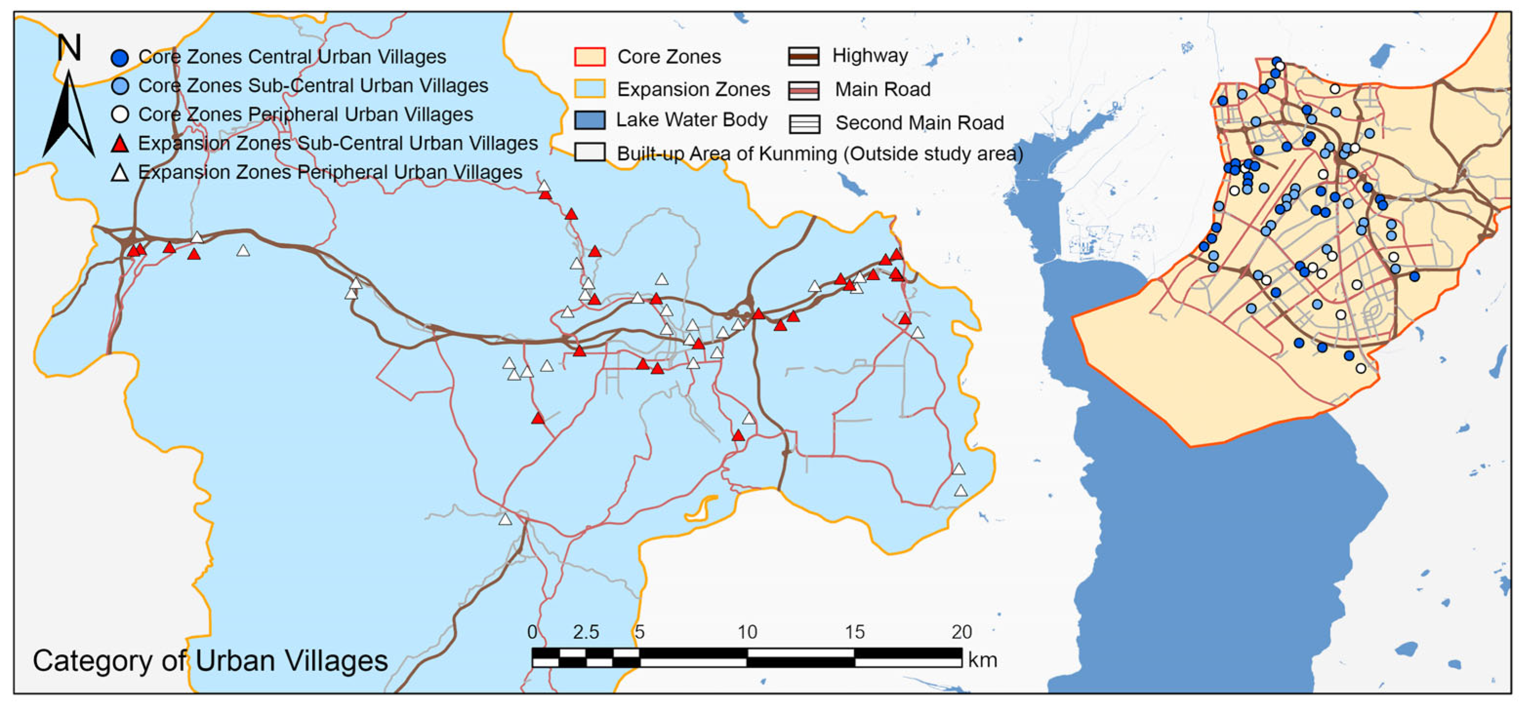
Empirical results indicate that no urban villages in Anning City (the expansion zone) currently meet the accessibility standards required for central-level classification. This outcome is consistent with the relatively limited concentration of high-end services and transportation hubs in the expansion zones at their current stage of development. Consequently, this study concentrates on five categories for detailed analysis: core zone central urban villages, core zone sub-center urban villages, core zone peripheral urban villages, expansion zone sub-center urban villages, and expansion zone peripheral urban villages. The spatial distribution of these categories is illustrated in Figure 2.

2.3.2. Evaluation of Urban Village Development Status

  • Indicator System Establishment
The development status of urban villages reflects a comprehensive outcome shaped by multiple factors, including regional resource endowments, functional positioning, facility services, population composition, and economic conditions. This integrated value serves as a crucial foundation for determining appropriate renewal strategies. Previous research on urban villages has primarily examined the living conditions of migrant populations through social surveys focusing on rental areas, housing prices, building quality, infrastructure, sanitation, and public security [40,41,42]. Given the dual urban–rural nature of urban villages, their evaluation requires an approach that integrates both urban human settlement assessments and rural development metrics.
From an urban perspective, Karen Witten and colleagues quantitatively assessed community living environments in New Zealand by analyzing accessibility in six service areas: recreational facilities, public transport, commercial and financial services, education, healthcare, and socio-cultural services [43]. In Taiwan, Chiang and Liang developed an urban ecological livability index to evaluate environmental quality across 28 cities [44]. Similarly, Daisy Das assessed habitat quality in Guwahati by examining material, social, and economic conditions [45]. From a rural perspective, Zhang Rongtao and co-authors built an evaluation system based on population growth, industrial development, and land use efficiency [46]. Han Xiaoyan organized indicators into three categories: living (daily life and social governance), production (agricultural and non-agricultural economies), and ecology (natural conditions and infrastructure) [47]. Long Honglin focused on rural economic development, agricultural productivity, and social services [48].
These studies consistently highlight location, resource conditions, and socioeconomic development status as core factors for evaluating urban village development. Location, in particular, has already been incorporated as a key dimension in the classification framework introduced earlier. Drawing on relevant literature and policy documents, this study screened frequently used indicators and analyzed survey data characteristics to construct a tailored evaluation index system. The resulting framework encompasses four assessment dimensions, eight evaluation categories, and fourteen supporting datasets, with clearly documented data sources and processing methods to ensure both scientific rigor and practical applicability (Table 2).
2.
Weight Assignment Using the Analytic Hierarchy Process
Urban villages lack a universally accepted definition, and assessing their development status involves multiple complex dimensions that require expert insight and consideration of local policy contexts. To address this complexity, the Analytic Hierarchy Process (AHP) was employed for assigning weights, given its flexibility and capacity to integrate both subjective judgments and objective data [49,50].
The evaluation system was structured into a hierarchical model consisting of three levels: the goal level (O), representing the overall evaluation of urban village development status; the criterion level (C), which includes four dimensions ecological environment, spatial intensity, social resilience, and economic vitality; and the indicator level (I), comprising 14 specific indicators such as the ratio of agricultural land area and green coverage rate. This arrangement forms a clear, tree-like hierarchical structure.
Subsequently, judgment matrices were constructed, requiring each expert to develop positive and negative reciprocal matrices for both the four dimensions at the criterion level and the fourteen elements at the indicator level. For the dimension (C1) at the criterion level, the judgment matrix was formulated as follows:
A C 1 = 1 a 12 a 1 n 1 / a 12 1 a 2 n 1 / a 1 n 1 / a 2 n 1
The element a i j represents the relative importance scale value of factor i compared to factor j , which must satisfy a i j = 1 / a j i   and   a i i = 1 . Subsequently, consistency verification is performed by calculating weights through the eigenvalue method. For each judgment matrix, the maximum eigenvalue λ m a x is computed as follows:
λ m a x = 1 n i = 1 n ( A W ) i W i
The eigenvector component W i is obtained by normalizing the matrix columns and then calculating the row averages:
W i = 1 n j = 1 n a i j κ = 1 n a κ j
The consistency index C I and consistency ratio C R are computed as follows:
C I = λ m a x n n 1 , C R = C I R I
where R I represents the random consistency index. A matrix is considered consistent when C R < 0.1 . For matrices failing to meet this criterion, experts were required to readjust the scale values. After three rounds of adjustments, all matrices achieved C R values within the 0.02–0.09 range. The geometric mean method was employed to aggregate weight calculations from ten experts. For any specific weight W κ at the indicator level, its comprehensive value is calculated as:
W c o m p r e h e n s i v e = m = 1 10 W κ ( m ) 10
The complete weighting system (Table 3) was generated using Yaahp software 12.1 to process 420 pairwise comparison datasets.
3.
Data Quantification and Standardization
Given the multi-source heterogeneous data characteristics in urban village evaluation, differentiated standardization methods were applied to integrate indicators on a unified scale. For continuous proportional data (e.g., agricultural land area ratio X i ) and absolute scale data (e.g., collective construction land area X i ), range standardization was employed to mitigate extreme value effects and normalize values to the [0, 1] interval:
X i = x i x m i n x m a x x m i n
For scoring-based data (e.g., completeness of public service facilities), the ratio of total score S m a x to actual score S j was calculated using the cumulative addition method:
X i = S j S m a x
Ultimately, all indicators were uniformly standardized to [0, 1] scaled scores, supporting multi-dimensional comprehensive evaluation and ensuring data comparability.

2.3.3. Quantitative Comparative Analysis

This study examines intra-city variations in urban villages through a two-level comparative analysis. At the intra-regional level, hierarchical comparisons were conducted between core, sub-core, and peripheral zones in Guandu District and Anning City. At the inter-regional level, cross-boundary comparisons were made between these two administrative divisions.
Initially, the distribution characteristics of five key dimensions in sub-center and peripheral urban villages within the expansion zones were analyzed using boxplot visualization [51].
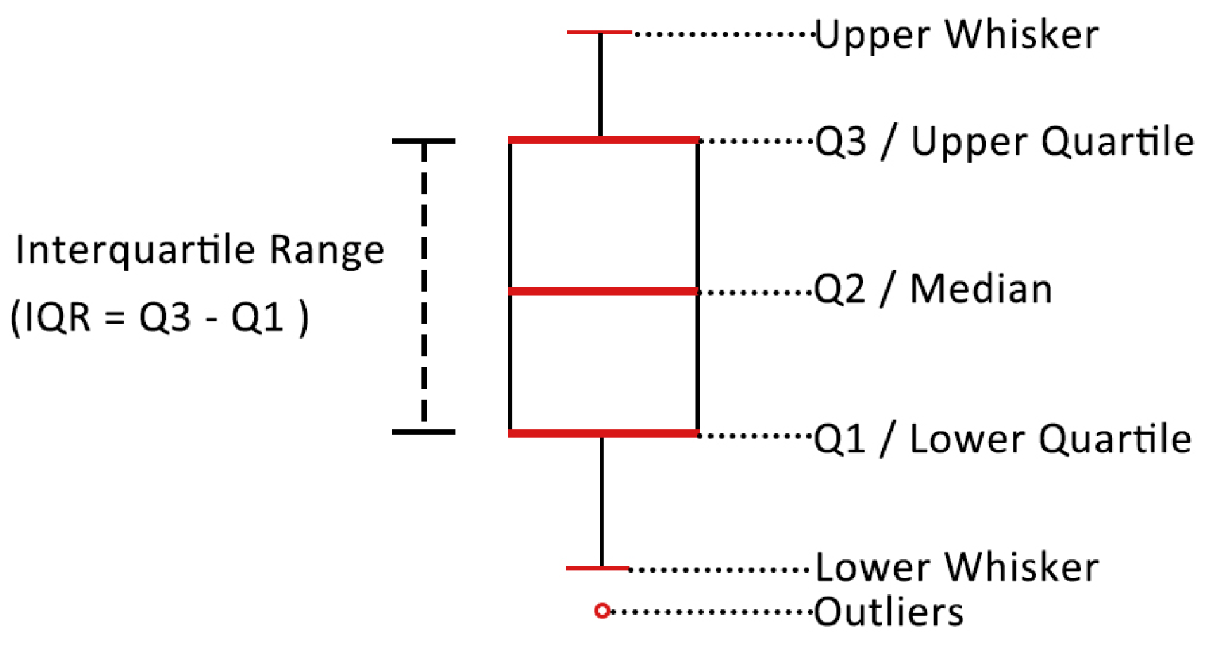
In the boxplot (Figure 3), data points are arranged in ascending order. The first quartile (Q1) represents the 25th percentile, the median (Q2) indicates the 50th percentile, and the third quartile (Q3) corresponds to the 75th percentile. The interquartile range (IQR) is calculated as the difference between Q3 and Q1. The upper whisker extends to the maximum observed value within Q3 + 1.5 × IQR, while the lower whisker reaches the minimum observed value within Q1 − 1.5 × IQR. The overall range is defined as the difference between the maximum and minimum observed values, with any data points beyond this range classified as outliers. Q1 and Q3 mark the boundaries of the central 50% of the data, and their position relative to the median helps identify left- or right-skewed distributions. The median (Q2) reflects the central tendency, remaining robust against extreme values. The IQR provides a measure of data concentration and dispersion, while outliers highlight exceptional cases.
Following this, a radar chart analysis based on median values was conducted to visualize core dimensional differences. For dimensions showing significant variation, a Pearson correlation analysis was performed to explore interaction mechanisms between indicators through the calculation of inter-dimensional correlation coefficient matrices.

3. Results

3.1. Analysis of Intra-Regional Variations in Urban Villages

3.1.1. Intra-Regional Variations in Anning City

This study examined five key attributes ecological environment, spatial intensity, social resilience, economic vitality, and development status across different types of urban villages in Anning City (expansion zones).
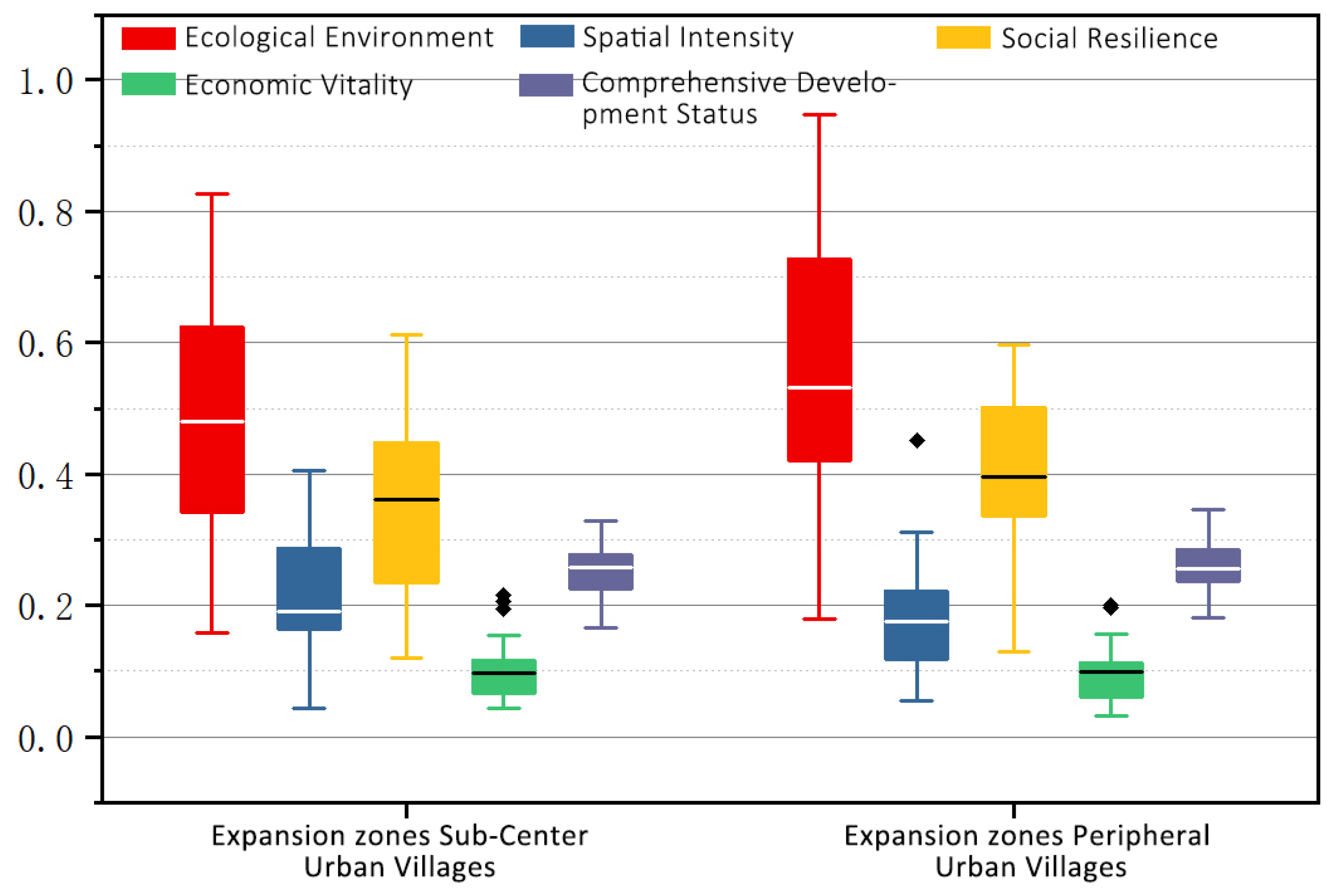
Boxplot analysis (Figure 4) revealed the following:
  • Ecological Environment
Both types of urban villages in the expansion zones showed high median values (Q2) and wide interquartile ranges (IQR), indicating generally favorable ecological conditions but considerable variation among villages. Peripheral urban villages exhibited higher Q1, Q2, and Q3 values, suggesting stronger ecological performance overall.
2.
Spatial Intensity
Both types displayed low median values and narrow IQRs, reflecting generally limited spatial intensity concentrated within the expansion zones. Sub-center urban villages exhibited right-skewed distributions (with Q1 closer to Q2), indicating that most samples clustered at lower values, though a few high-value outliers raised Q3. Peripheral urban villages showed mostly symmetric distributions, except for one notable outlier, Wenquan Village (Figure 5a), which achieved exceptional spatial intensity through geothermal tourism development and efficient homestead utilization, becoming a national model for rural revitalization.
3.
Social Resilience
Both types demonstrated moderate median and IQR values. Peripheral urban villages had higher Q1 and Q2 values compared to sub-center villages. While sub-center urban villages showed a slight left skew (data concentrated in higher-value ranges), peripheral villages displayed right-skewness (data concentrated in lower-value ranges).
4.
Economic Vitality
Both urban village types exhibited low median values and narrow IQRs, indicating generally weak economic performance. Sub-center villages had symmetric distributions with several outliers, including Jile Village (Figure 5b), where collective community industries notably boosted local incomes. Peripheral urban villages showed right-skewed distributions, with most samples clustered toward higher values and one extreme outlier, Yuanshan Village (Figure 5c), which significantly improved collective and per capita incomes through integrated land management and centralized leasing of a farmers’ market.
5.
Comprehensive Development Status
Both types of urban villages exhibit similar overall conditions, with generally low development levels.
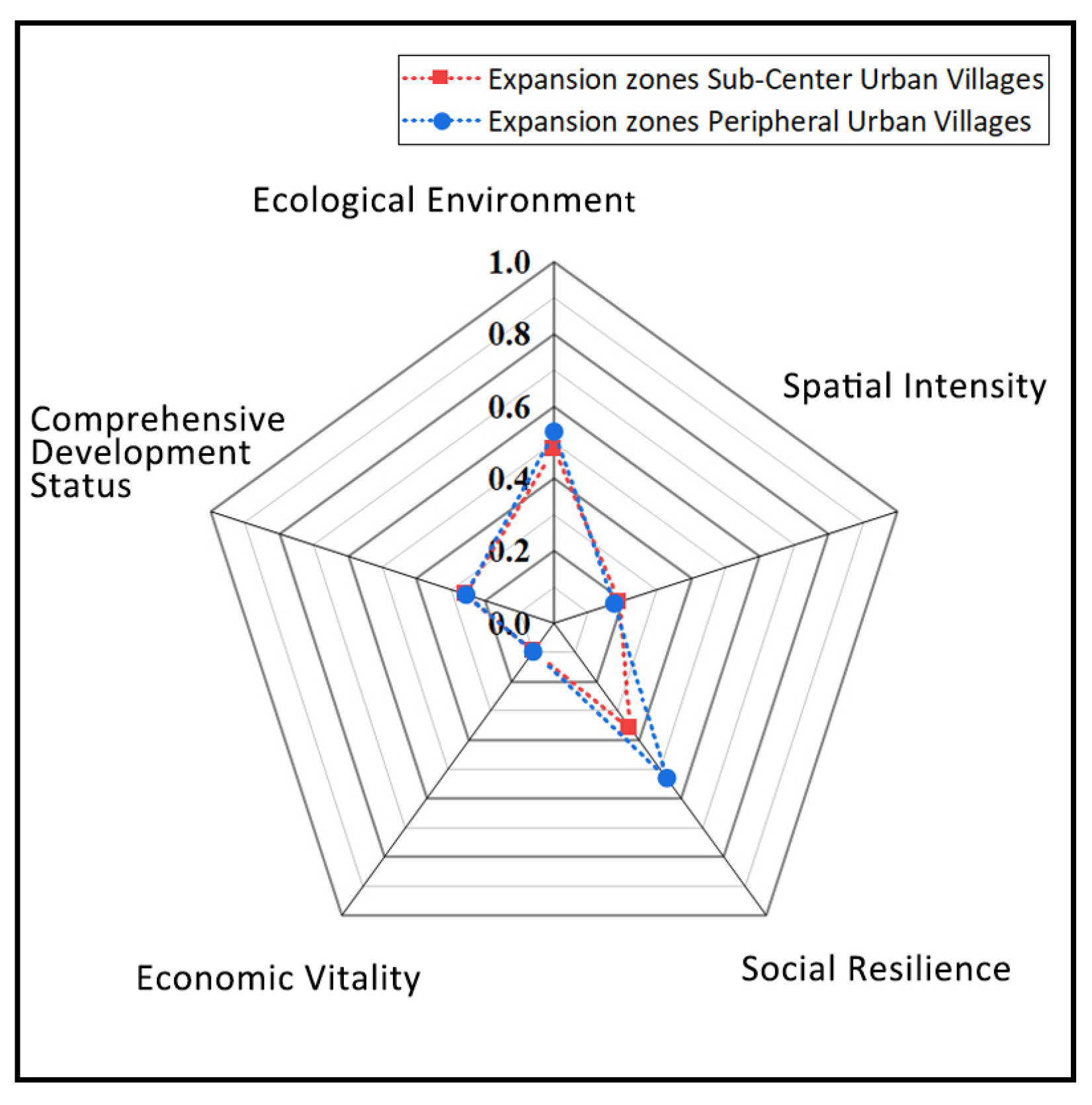
Radar chart analysis (Figure 6) revealed the following results:
Sub-center urban villages in the expansion zones demonstrate slightly lower ecological development levels than peripheral urban villages. Additionally, their social resilience levels are inferior to those of peripheral urban villages.

3.1.2. Intra-Regional Variations in Guandu District

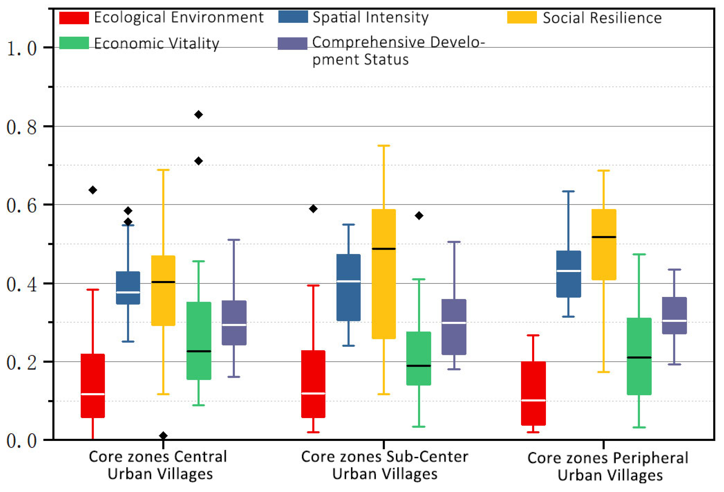
The study examined five key attributes across different types of urban villages in Guandu District (core zones).
Boxplot analysis (Figure 7) revealed the following results:
  • Ecological Environment
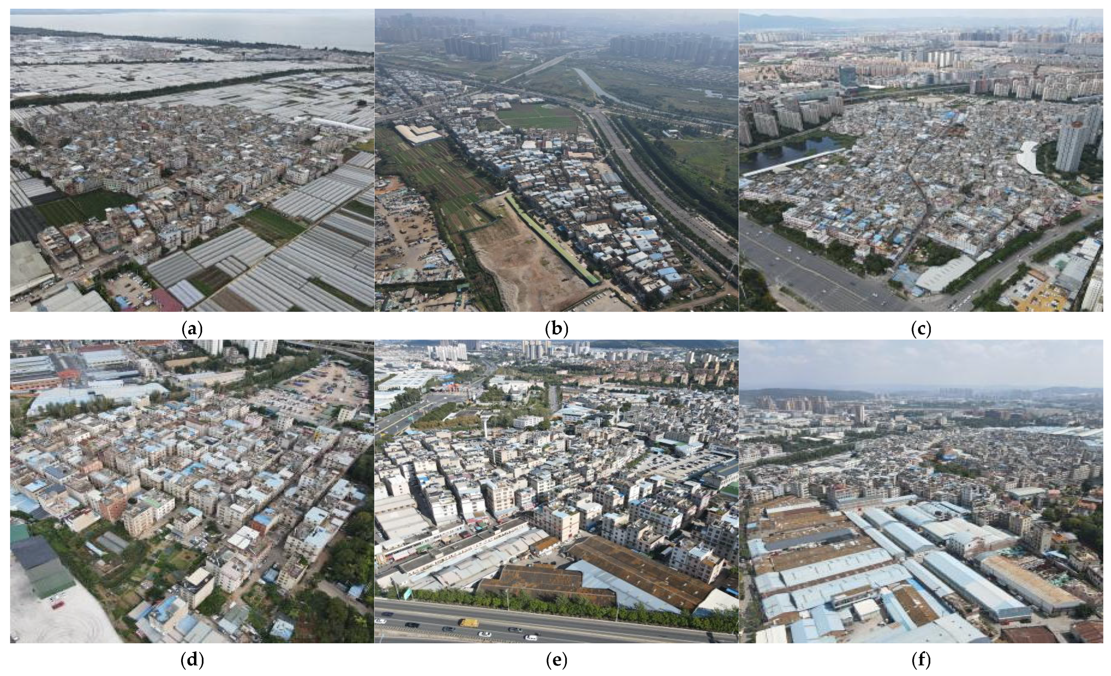
All three types of urban villages in the core area exhibited relatively low ecological performance overall. Among the central urban villages, Guansuo Village (Figure 8a) stood out as an extreme outlier, distinguished by its extensive agricultural land devoted to high-value flower cultivation. Similarly, Yongsheng Village (Figure 8b), classified as a sub-center urban village, maintained a significant area of grain cultivation. In contrast, peripheral urban villages showed more concentrated and less variable ecological data distributions.
2.
Spatial Intensity
Median values (Q2) were generally high across all urban village types, with central urban villages displaying smaller interquartile ranges (IQR), indicating more uniform spatial intensity. Sub-center urban villages had the largest IQR, reflecting greater variability within this group. Notably, two central urban villages Zijun Village (Figure 8c) and Hongren Village (Figure 8d) were identified as extreme outliers. Both benefit from prime commercial locations near major transit corridors, supported by thriving rental markets and business service industries, resulting in exceptionally high development intensity.
3.
Social Resilience
All three urban village types exhibited high median values (Q2) for social resilience, with central villages showing the highest median and the smallest interquartile range (IQR), indicating tightly clustered data. Sub-center villages displayed a left-skewed distribution, with most values concentrated at the higher end. Peripheral villages recorded the highest median Q2 overall. An extreme low outlier was identified in the central urban villages: Wangjia Village, which suffers from aging infrastructure, insufficient public services, severe population decline, and consequently, very low social resilience.
4.
Economic Vitality
Economic vitality showed similar median values and generally uniform distributions across all village types. Sub-center villages had the smallest IQR, reflecting more consistent economic performance. Within central urban villages, two notable high outliers Zhuyuan Village (Figure 8e) and Mingquan Village (Figure 8f) stood out. Both villages benefit from collective land leasing (22 ha and 14 ha, respectively) for industrial and warehouse purposes, generating significant income that supports growth in tertiary sectors such as accommodation, catering, and leasing, thereby increasing per capita earnings.
5.
Comprehensive Development Status
All three village types displayed comparable median values and generally uniform distributions, indicating similar moderate levels of overall development.
Radar chart analysis (Figure 9) further highlighted minimal differences among ecological environment, spatial intensity, economic vitality, and overall development status. For social resilience, peripheral urban villages ranked highest, followed by sub-center villages, while central urban villages ranked lowest.

3.2. Analysis of Inter-Regional Variations in Urban Villages

This study explores the distinctive characteristics of urban villages in core zones and expansion zones by analyzing five key attributes.
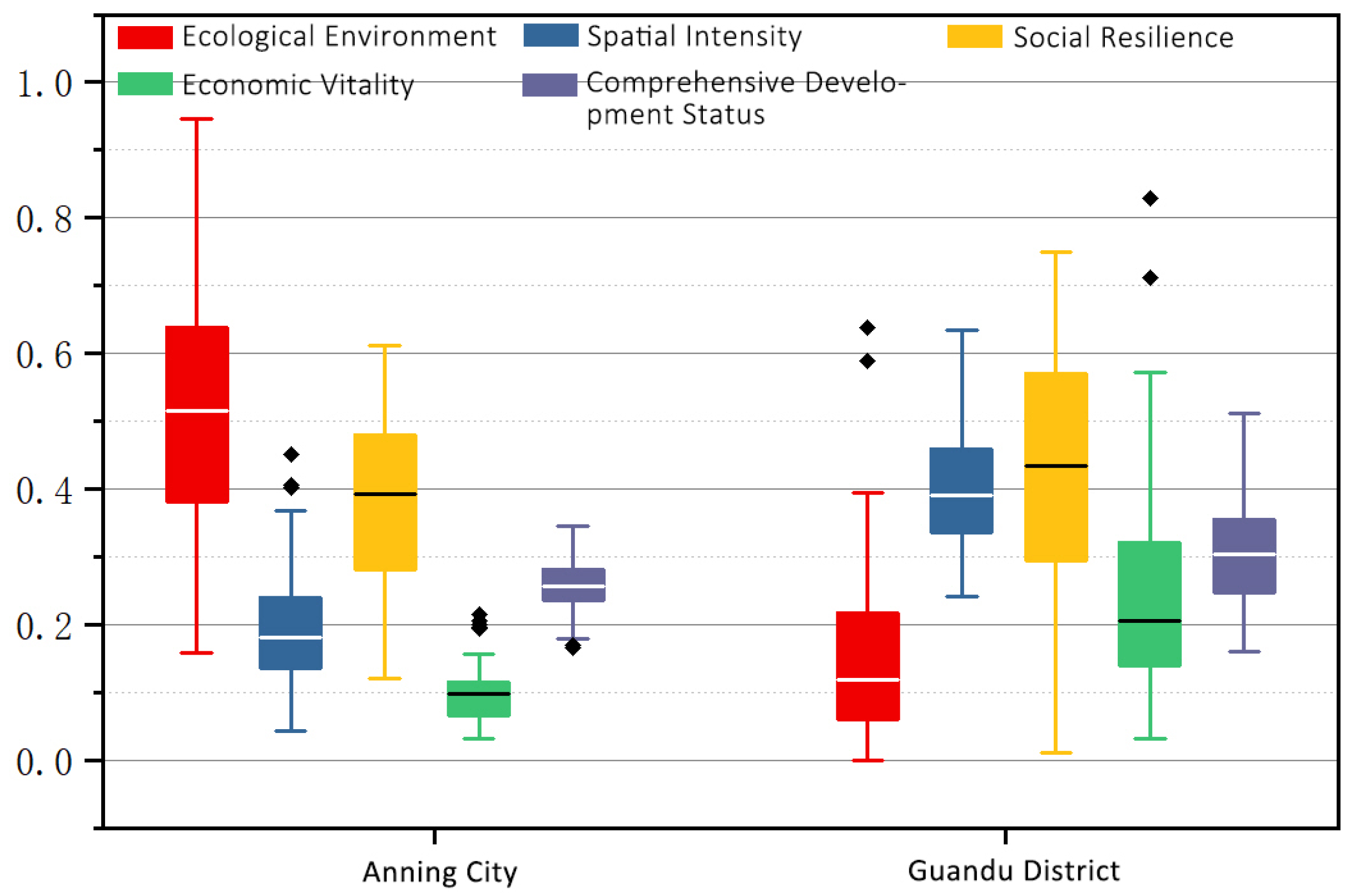
Boxplot analysis (Figure 10) yielded the following insights:
  • Ecological Environment
Urban villages in Anning City showed a significantly higher median value (Q2) compared to those in Guandu District, indicating overall better ecological conditions. The data distribution in Anning City was relatively balanced, whereas Guandu District’s distribution was right-skewed, with most samples clustered at lower values. Notably, two extreme outliers in Guandu Guansuo Village and Yongsheng Village demonstrate that urban villages in core zones with agriculture-based economies can attain ecological conditions comparable to the upper-middle range found in expansion zones.
2.
Spatial Intensity
Urban villages in Guandu District exhibited substantially higher median values than those in Anning City. Both regions had small interquartile ranges (IQRs) with concentrated, balanced distributions. In Anning City, two notable high outliers Wenquan Village, where tourism facilities boost spatial intensity, and Yiwan Shui Village, benefiting from its proximity to the city center with well-developed supporting infrastructure, indicate that some expansion zone villages with locational advantages or tourism specialization can reach spatial intensity levels comparable to the upper-middle tier of core zone villages.
3.
Social Resilience
Both regions had similar median values with relatively uniform distributions. Guandu District showed a larger IQR, suggesting greater variability in social resilience among urban villages in the core zones.
4.
Economic Vitality
The median economic vitality of urban villages in Anning City was slightly lower than that in Guandu District, reflecting generally weaker economic performance in the expansion zones. The smaller IQR and higher number of outliers in Anning suggest a pattern of “integrated concentration with localized excellence,” a generally balanced economic landscape with certain villages excelling through collective land consolidation and specialized industries. By contrast, economic disparities were more pronounced among villages within the core zones.
5.
Comprehensive Development Status
Guandu District showed a slightly higher IQR than Anning City, indicating somewhat better overall development levels in the core zones.
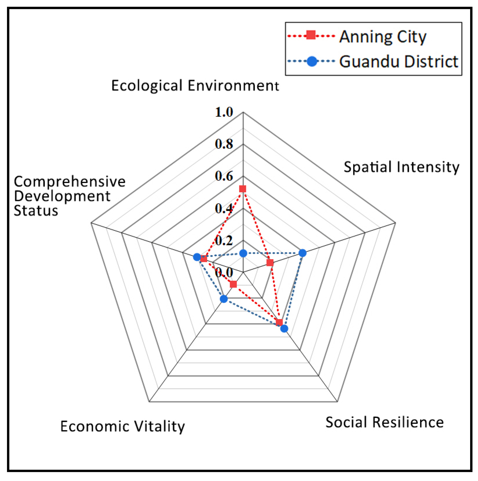
Radar chart analysis (Figure 11) revealed the following results:
Urban villages in Guandu District were found to exhibit marginally better social resilience and development status than those in Anning City, though the differences were not statistically significant. In contrast, Anning City’s urban villages demonstrated superior ecological conditions. However, Guandu District outperformed Anning City in both economic vitality and spatial intensity metrics.

3.3. Correlation Analysis

Previous studies have shown both differentiation and convergence among urban villages, both within and across regions. However, the mechanisms behind these patterns remain insufficiently understood. Descriptive statistics can reveal trends in individual indicators but often miss the complex interactions between them. In particular, more attention is needed to the coupling relationships among underlying indicators. Mean-value analysis at the dimensional level may hide internal contradictions within similar indicators. In contrast, examining cross-dimensional linkages can directly reveal key governance challenges. To explore these relationships, this section uses correlation analysis to uncover the structural drivers behind differentiation. This provides a clearer foundation for developing targeted governance strategies. Pearson correlation analysis was conducted on scheme-level indicators for urban villages in both zones using Origin software 2024. Only highly significant results (p ≤ 0.001) were selected for further interpretation.
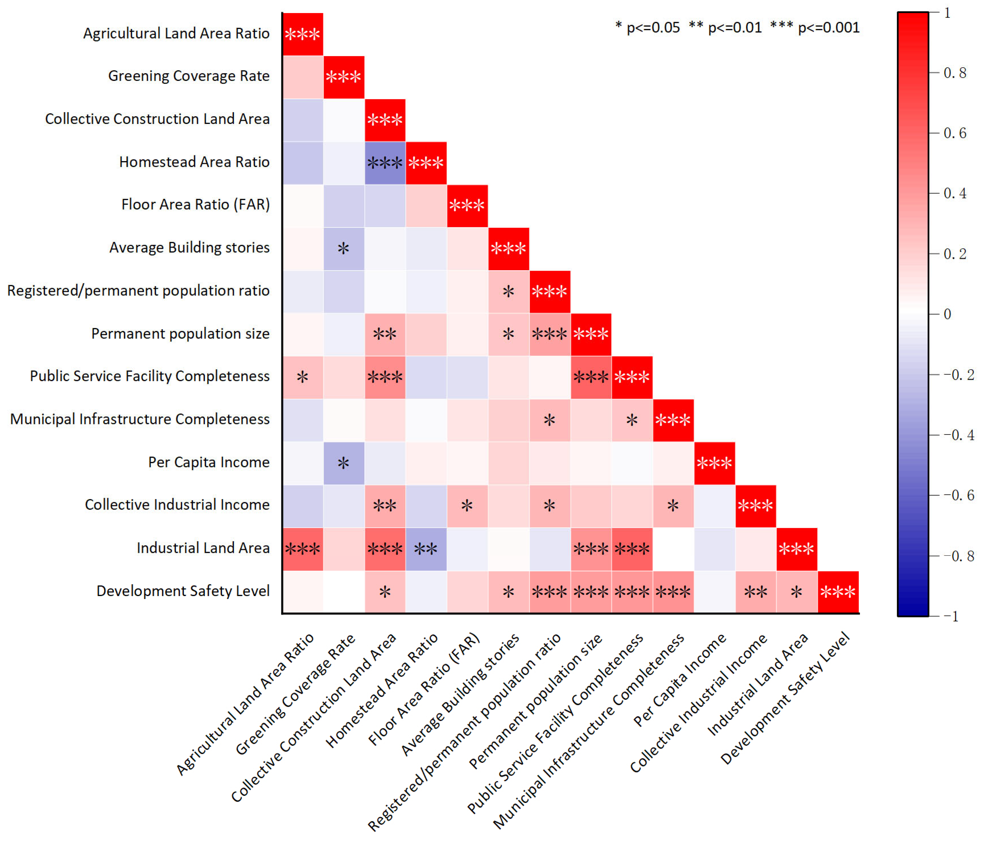
In the urban villages of Anning City (Figure 12), a strong positive correlation (0.4 < r < 0.6) was found between the proportions of industrial and agricultural land, suggesting a high degree of coupling between industrial/commercial activities and agriculture in the expansion zone. This pattern reflects the vertical integration of the agricultural industrialization chain, whereby the expansion zone leverages agricultural development to stimulate secondary and tertiary sectors such as agro-processing, storage, and ancillary services.
A strong positive correlation (0.4 < r < 0.6) was also observed between industrial land area and total construction land area, indicating that the expansion of industrial and commercial activities directly drives increased land development intensity in the expansion zone.
Conversely, a strong negative correlation (−0.6 < r < −0.4) was found between the proportion of residential land and agricultural land, highlighting a distinctive land use pattern and industrial structure within the expansion zone. Collective land is primarily divided into two dominant uses: residential and primary production, with limited diversification into higher value-added sectors such as cultural tourism or ecological industries. This fragmentation exacerbates spatial discontinuity typical of urban-rural transition areas.
Moderate to weak negative correlations (r > −0.4) were found between (1) total permanent population and green coverage rate, and (2) development/construction safety index and green coverage rate. These findings suggest a pattern of passive expansion and functional disconnection in urban villages within the expansion zone. Residential and industrial activities tend to cluster in isolated pockets around the core sarea, leaving undeveloped spaces dominated by leftover native vegetation or farmland. This creates a simple spatial pattern of “construction patches” scattered over a green matrix. Interestingly, higher green coverage often corresponds to weaker urban functionality. The area neither achieves dense urban development nor preserves a fully intact rural ecological system, showing the typical “construction-ecology binary collage” seen in urban-rural transition zones.
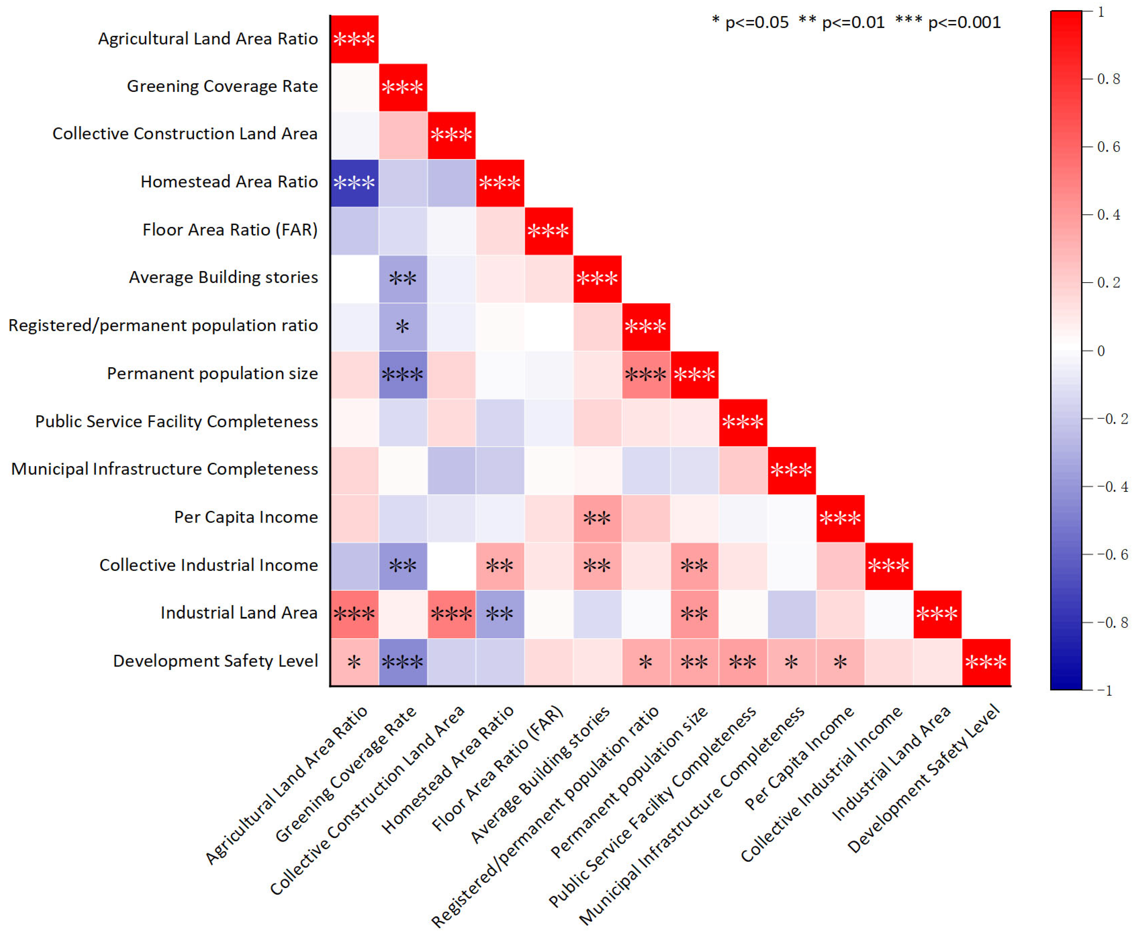
In the urban villages of Guandu District (Figure 13), strong positive correlations (0.4 < r < 0.6) were observed between industrial land area and three indicators: agricultural land proportion, collective construction land area, and public service completeness. A moderate positive correlation (0 < r < 0.4) was also found with permanent population size. These results suggest a synergistic relationship between agricultural industrialization and commercial-industrial development in core-zone urban villages. Agricultural land promotes the agglomeration of secondary and tertiary industries through the vertical extension of the industrial chain. Meanwhile, industrial expansion drives a rigid demand for land scale and infrastructure hardening, necessitating the expansion of collective construction land for industrial park development. Although industrial clustering substantially enhances urban functions, its current influence on population concentration remains limited.
Public service completeness exhibited a moderate positive correlation (0 < r < 0.4) with collective construction land area and a strong positive correlation (0.4 < r < 0.6) with permanent population size. This reflects the coordinated interplay between production capacity and community governance efficiency. The scale effects of collective land and population size promote unified planning and increased capital investment. Population growth intensifies demand for public service upgrades, while revenues generated from collective land use partially fund public facility construction, attracting migrant tenants and fostering a virtuous cycle.
Development safety showed moderate positive correlations (0 < r < 0.4) with permanent population size, household-to-permanent population ratio, public service completeness, and municipal infrastructure completeness. This indicates that population inflows generate scale economies, enabling improvements in public services and infrastructure that collectively enhance construction safety.
A statistically significant negative correlation (−0.6 < r < −0.4) was observed between the proportion of residential land and the area of collective construction land. This pattern suggests potential land scarcity in urban villages within the core zone, reflecting a conflict between traditional residential land use and market-oriented collective land allocation. These findings indicate a broader transition in land use strategies, where residential functions are gradually being supplanted by industrial and commercial development in high-density urban areas.

4. Discussion

4.1. Summary of Intra-City Differences in Urban Villages

4.1.1. Intra-Regional Differences Among Urban Villages

The analysis reveals that urban villages at different functional levels within the same region tend to exhibit similar characteristics across most dimensions, with social resilience standing out as the only dimension showing significant variation. Outlier cases across hierarchical levels, however, demonstrate distinct development pathways, using diverse strategies to overcome spatial constraints.
In urban expansion zones, peripheral urban villages generally exhibit higher levels of social resilience than sub-center villages. Sub-center villages are clustered within low-resilience ranges, while peripheral villages are concentrated in higher-resilience ranges. A similar pattern is observed in core urban zones: peripheral villages outperform sub-center villages, which in turn surpass central villages. This suggests an inverse relationship between functional hierarchy and social resilience within the same region.
Two key mechanisms help explain this pattern. First, higher-level villages attract more migrant populations, leading to lower household-to-permanent population ratios, which can destabilize community structures and reduce social resilience. Second, lower-hierarchy villages typically face fewer barriers to upgrading public services and infrastructure due to lower redevelopment costs. In contrast, central villages struggle with high population densities, complex land ownership patterns, and aging infrastructure, all of which hinder the provision and renewal of basic services.
In expansion zones, outlier villages often achieve notable breakthroughs in economic vitality. Sub-center villages increase returns on collective assets by using market-oriented management through collective economic organizations. Peripheral villages, on the other hand, focus on land-intensive strategies such as developing logistics parks. This shows a clear spatial gradient in how resources are used across the hierarchy. In core zones, outliers mainly stand out in ecological environment, spatial intensity, and economic vitality. Central villages turn ecological advantages into high-value agricultural activities like floriculture. Sub-center villages emphasize scaled-up traditional crop cultivation. Central villages also benefit from their prime locations by achieving high development intensity and generating significant revenue through land consolidation and leasing. These examples highlight the varied strategies of resource use based on each village’s functional role.

4.1.2. Inter-Regional Differentiation Among Urban Villages

Regarding spatial efficiency, urban villages in the core zone outperform those in the expansion zone. Core villages benefit from agglomeration effects, enabling mixed land use and significant increases in development intensity. The competition between traditional residential functions and market-driven uses further enhances spatial efficiency. In contrast, expansion zones, limited by functional homogeneity and restricted factor mobility, show weaker spatial efficiency.
Economic vitality patterns vary significantly between the two regions. Villages in the expansion zone tend to have lower economic levels with clustered vitality scores, although some outliers manage to achieve exceptionally high values by overcoming these constraints. Core-zone villages generally exhibit higher overall economic vitality but also greater internal disparities, with a few cases surpassing hierarchical limits through land capitalization strategies.

4.2. Core Characteristics and Regeneration Strategies for Urban Villages

Based on empirical analysis, this study identifies five types of urban villages and proposes tailored regeneration strategies for each (Table 4).
Core Zone Central Urban Villages, as key urban functional hubs, feature high-density development and mixed land uses. Located near transit hubs with excellent service accessibility, they face intense competition between residential and industrial land driven by land capitalization. Population inversion leads to service overload, though some manage to generate ecological value through high-value agriculture. Regeneration should focus on adopting TOD models for vertical mixed-use development; establishing flexible land exchange mechanisms to convert low-efficiency warehouses into innovative spaces; implementing tiered service systems to ease population pressure; and preserving agricultural patches to support eco-economic synergy.
Core Zone Sub-Center Urban Villages, acting as intermediate urban gradients, have lower spatial accessibility and less severe land use conflicts than central villages. Some maintain ecological value by preserving contiguous farmland. Recommended strategies include functional retrofitting aligned with their sub-center role; consolidating fragmented collective construction land; protecting crop zones to form agricultural corridors; strengthening residential dominance; and improving living environments through appropriate functional mixing.
Core Zone Peripheral Urban Villages, which serve as urban decompression buffers, display strong social resilience due to stable demographics and lower regeneration costs. Their homogeneous, low-intensity development reflects balanced growth without outliers. Suggested approaches include incremental upgrades to water and sewer infrastructure; developing neighborhood service networks; revitalizing traditional architecture via craft workshops; and promoting peri-urban tourism, combining farm markets and eco-lodging to rejuvenate spaces while preserving social networks.
Expansion Zone Sub-Center Urban Villages, positioned as industrial transition areas, hold ecological advantages but suffer from low spatial efficiency, characterized by “weak overall but locally strong” economic vitality. Exceptional cases, such as hot-spring tourism clusters, overcome hierarchical limitations. Strategies should prioritize protecting ecological foundations like mountains and farmland by transforming them into recreational spaces; replicating successful “specialty resources + collective operations” models; and unlocking spatial potential within ecological boundaries.
Expansion Zone Peripheral Urban Villages, as the final urban-rural frontiers, possess superior yet underutilized ecology, agriculture-dominated economies, and insufficient services. Land intensification allows for some breakthroughs. Recommended interventions include developing digital agricultural supply chains, monetizing ecological assets through carbon trading, deploying mobile healthcare and education services, consolidating collective land for agro-tourism, and establishing eco-compensation mechanisms to support these semi-urbanized areas.

5. Conclusions

This study systematically uncovers the intra-city differentiation of urban village development through empirical analysis of representative cases in Kunming, establishing a “spatial location-functional hierarchy” analytical framework. The findings reveal strong convergence within regions but significant structural differences between regions. These differentiation patterns fundamentally reflect the interplay between urban planning systems and grassroots spatial practices. Urban planning institutions, through functional zoning and resource allocation, create a regulatory framework that drives high-intensity development in core areas and leads to inefficient lock-in in expansion areas. At the same time, intra-regional convergence arises from homogeneous spatial practices constrained by the collective land system, manifesting as residential homogenization and dominance of the rental economy.
The study proposes five typological regeneration strategies: (1) for core zone Central Urban Villages, establish a TOD-oriented three-dimensional development system that incorporates flexible land replacement and innovation space cultivation; (2) for core zone Sub-Center Urban Villages, implement functional retrofitting to improve residential quality and community services; (3) for core zone Peripheral Urban Villages, pursue incremental renewal with cultural catalysts to activate peri-urban micro-cultural tourism; (4) for expansion zone Sub-Center Urban Villages, develop differentiated models centered on “specialty resources + collective operations”; and (5) for expansion zone Peripheral Urban Villages, explore innovative ecological value transformation mechanisms, including digital agriculture and carbon sequestration pathways.
Theoretically, this study innovatively integrates polycentric urban theory with spatial accessibility analysis, developing a “three-indicator, two-tier” classification system that overcomes the limitations of single-case studies. It establishes a transferable spatial governance evaluation framework to support targeted urban village renewal. Methodologically, the large-sample intra-city comparison effectively controls for urban hierarchy interference, systematically revealing differentiation patterns at the intra-city scale. The combined “field survey + cadres interview” approach addresses data scarcity challenges in informal settlement research, filling critical gaps in quantitative studies of informal spaces.

Author Contributions

Conceptualization, W.D.; Methodology, J.R. (Jiarui Ren); Software, J.R. (Jiarui Ren), S.Y. and J.Z.; Formal analysis, J.R. (Jiarui Ren); Investigation, J.R. (Jiarui Ren), S.Y., J.Z. and J.R. (Jiacheng Rao); Data curation, J.R. (Jiacheng Rao); Writing—original draft, J.R. (Jiarui Ren); Writing—review & editing, W.D. and J.R. (Jiarui Ren); Visualization, S.Y., J.Z. and J.R. (Jiacheng Rao); Supervision, W.D. and N.T.; Project administration, W.D. and N.T.; Funding acquisition, W.D. and N.T. All authors have read and agreed to the published version of the manuscript.

Funding

This research was funded by National Natural Science Foundation of China: 52208061 and Yunnan Province Science and Technology Department: 202401CF070132. The APC was funded by National Natural Science Foundation of China: 52208061 and Yunnan Province Science and Technology Department: 202401CF070132.

Institutional Review Board Statement

Based on standard ethical guidelines, Institutional Review Board approval was not required for this study.

Informed Consent Statement

Informed consent was obtained from all subjects involved in the study.

Data Availability Statement

The original contributions presented in the study are included in the article; further inquiries can be directed to the corresponding author.

Acknowledgments

Thanks to every participant and staff member who contributed to the data collection of this article.

Conflicts of Interest

The authors declare no conflicts of interest.

References

  1. State Council Office of the People’s Republic of China. Guiding Opinions on Positively and Steadily Promoting the Transformation of Urban Villages in Mega Megacities. Available online: https://www.gov.cn/zhengce/2021-10/10/content_5641727.htm (accessed on 10 October 2021).
  2. Ministry of Housing and Urban-Rural Development. Notice on Preventing Large-Scale Demolition and Construction in Urban Renewal Actions. Available online: https://www.gov.cn/zhengce/zhengceku/2021-08/31/content_5634560.htm (accessed on 27 June 2025).
  3. State Council Office of the People’s Republic of China. The 2023 State CouncilGuiding Opinions on Promoting Urban Village Regeneration in Super-Large and Megacities. Available online: https://www.gov.cn/zhengceku/content/202307/content_7025843.htm (accessed on 28 June 2025).
  4. Yu, W. Evolution and Reorganization of Spatial Structure in Beijing’s Urban Fringe Areas; Science Press: Beijing, China, 2012; ISBN 978-7-03-034352-9. Available online: https://book.douban.com/subject/10771460/ (accessed on 17 August 2025).
  5. Wehrwein, G.S. The Rural-Urban Fringe. Econ. Geogr. 1942, 18, 217–228. [Google Scholar] [CrossRef]
  6. U–TT Archive|Informal City: Caracas Case. Available online: http://urban-thinktank-hk.ch/utt-archive/publication/informal-city-caracas-case/ (accessed on 31 March 2025).
  7. Berner, E. Informal Housing: Asia. In International Encyclopedia of Housing and Home; Smith, S.J., Ed.; Elsevier: San Diego, CA, USA, 2012; pp. 56–62. ISBN 978-0-08-047171-6. [Google Scholar]
  8. Johnstone, M. Urban Housing and Housing Policy in Peninsular Malaysia. Int. J. Urban Reg. Res. 1984, 8, 497–529. [Google Scholar] [CrossRef]
  9. United Nation. Estimates and Projections of Urban, Rural and City Populations, 1950–2025: The 1982 Assessment; United Nation: New York, NY, USA, 1985. [Google Scholar]
  10. Roy, A. Urban Informality: Toward an Epistemology of Planning. J. Am. Plan. Assoc. 2005, 71, 147–158. Available online: https://www.tandfonline.com/doi/abs/10.1080/01944360508976689 (accessed on 31 March 2025). [CrossRef]
  11. Aguilar, A.G.; Ward, P.M.; Smith Sr, C.B. Globalization, Regional Development, and Mega-City Expansion in Latin America: Analyzing Mexico City’s Peri-Urban Hinterland. Cities 2003, 20, 3–21. [Google Scholar] [CrossRef]
  12. Willis, K. Informal Settlements. In International Encyclopedia of Human Geography; Elsevier: Amsterdam, The Netherlands, 2020; pp. 289–295. [Google Scholar]
  13. Loggia, C.; Govender, V. A Hybrid Methodology to Map Informal Settlements in Durban, South Africa. Proc. Inst. Civ. Eng. Eng. Sustain. 2020, 173, 257–268. [Google Scholar] [CrossRef]
  14. Vieda Martínez, S.; Ramírez-Mosquera, A.K.; Avalos, P.D. Impacts of Social Housing on Urban Transformations of Informal Settlements in Bogotá, Colombia. J. Hous. Built Environ. 2024, 39, 2069–2095. [Google Scholar] [CrossRef]
  15. Ren, X. Governing the Informal: Housing Policies Over Informal Settlements in China, India, and Brazil. Hous. Policy Debate 2018, 28, 79–93. [Google Scholar] [CrossRef]
  16. Tian, L. Some Reflections on China’s Land Use Development Strategy—A Discussion on the Countermeasures for the Coordinated Development of Human-Land Relations in China. Mod. Urban Stud. 1998, 62, 42–45. [Google Scholar]
  17. Wan, C.W.; Long, X.R. Review and Prospect of the Research on Renewal of Urban Villages in China—Literature Analysis Based on Major Journals in Urban Planning. West. Habitat J. 2022, 37, 78–86. [Google Scholar] [CrossRef]
  18. Zhou, X. The Urban Village Problem: An Economic Analysis of Formation, Survival and Transformation. Ph.D. Thesis, Fudan University, Shanghai, China, 2007. [Google Scholar]
  19. Yao, M. Study on the Transformation Strategy of “City-Side Villages” in the Development of New Areas of Xi’an City. Master’s Thesis, Xi’an University of Architecture and Technology (XUAT), Xi’an, China, 2009. [Google Scholar]
  20. Liu, W. Study on the Renewal Strategy of Shenzhen Urban Villages under the Concept of Urban Repair—Taking Shootgang Village as an Example. Archit. Cult. 2021, 126–128. [Google Scholar] [CrossRef]
  21. Fan Experience and Reference of Urban Village Development Based on Strategy Orientation; China Construction Company: Beijing, China, 2014; pp. 62–63.
  22. Yin, Y. Enhancement of Housing Rental and Livelihood Capacity of Households of Urban Village Demolition and Rehabilitation Residents—A Case Study of Eight Demolition and Rehabilitation Neighborhoods in Hanyang District of Wuhan City. Urban Issues 2020, 86–93, 103. [Google Scholar] [CrossRef]
  23. Zhang, D.; Cai, Y. The Differentiation of Housing Properties of Demolished and Relocated Residents in Urban Villages and Its Influencing Factors—Taking Two Demolished and Relocated Resettlement Areas in Wuhan City as an Example. Urban Issues 2018, 55–65. [Google Scholar] [CrossRef]
  24. Zhang, L. Comparison of Urban Renewal Governance Models and Transformation Path under the “New Normal”. Urban Dev. Stud. 2015, 22, 57–62. [Google Scholar]
  25. Lin, Y. Rural Industrialization in Semi-Urbanized Areas under the Perspective of Rural Governance: A Comparative Study Based on the Pearl River Delta, Southern Jiangsu and Wenzhou. J. Urban Plan. 2015, 101–110. [Google Scholar] [CrossRef]
  26. Wan, C. Public Product Orientation: Urban Village Renewal with Multi-Center Governance: The Case of Shenzhen Shuiwei Lemon League Talent Apartments. Int. Urban Plan. 2021, 36, 138–147. [Google Scholar] [CrossRef]
  27. Jiang, C.; Wang, T. Experimenting with Planning Control Reforms to Promote Clear Property Rights—And the Transformation of “Villages in Cities”. Town Plan. 2002, 33–40. [Google Scholar]
  28. Chen, Z. Multi-Faceted Thinking in the Transformation of “Urban Village”-Xiamen Lingdou Village Transformation Planning Practice. Planner 2016, 32, 21–24. [Google Scholar]
  29. Chen, S.; Zhao, W.; Hu, S. Study on Urban Village Transformation Planning under the Perspective of Habitat Environment Theory—Taking Wuhan City as an Example. Town Plan. 2009, 33, 37–42. [Google Scholar]
  30. Liu, M. Institutional Analysis of the Mechanisms of the Generation and Continuity of Urban Villages; Guangdong Social Sciences: Guangzho, China, 2010; pp. 157–162. [Google Scholar]
  31. Lan, Y. Urban Village Community—A Case Study on the Organizational and Lifestyle Approach to Peasant Urbanization. Soc. Sci. China 2005, 144–154, 207. [Google Scholar]
  32. He, L. Why Urban Villages Make a Difference—Distinguishing Between Same-City Differences and Different-City Differences. Acad. Mon. 2018, 50, 80–89. [Google Scholar] [CrossRef]
  33. Zhang, X.; Yuan, P.; Shan, R. An Innovative Discussion of Structural Zoning in Urban Master Planning. Shanghai Urban Plan. 2023, 145–151. [Google Scholar] [CrossRef]
  34. Ye, Y. Chinese-style modernization and transformation of urban villages in mega mega cities. Planner 2024, 40, 152–159. [Google Scholar]
  35. Liu, J.; Long, F.; Chen, L.; Zheng, L.; Mi, Z. The Role of Polycentric Urban Structures in Shaping Low-Carbon Lifestyles. Cities 2025, 157, 105616. [Google Scholar] [CrossRef]
  36. Gurría-Gascón, J.-L.; Sánchez-Martín, J.-M.; Ruiz-Labrador, E.-E.; Hernández-Carretero, A.-M. Polycentric Urban System, Territorial Development and Resilience of the Rural Population (Extremadura, Spain). Urban Sci. 2024, 8, 144. [Google Scholar] [CrossRef]
  37. Meijers, E.J.; Burger, M.J. Spatial Structure and Productivity in US Metropolitan Areas. Environ. Plan. A Econ. Space 2010, 42, 1383–1402. [Google Scholar] [CrossRef]
  38. Burger, M.J.; Meijers, E.J.; Hoogerbrugge, M.M.; Tresserra, J.M. Borrowed Size, Agglomeration Shadows and Cultural Amenities in North-West Europe. Eur. Plan. Stud. 2014, 23, 1090–1109. [Google Scholar] [CrossRef]
  39. GB/T 51328-2018; Urban Comprehensive Transportation System Planning Standard. China Architecture & Building Press: Beijing, China, 2018.
  40. Chan, R.C.K.; Yao, Y.M.; Zhao, S.X.B. Self-Help Housing Strategy for Temporary Population in Guangzhou, China. Habitat Int. 2003, 27, 19–35. [Google Scholar] [CrossRef]
  41. Leaf, M. A Tale of Two Villages: Globalization and Peri-Urban Change in China and Vietnam. Cities 2002, 19, 23–31. [Google Scholar] [CrossRef]
  42. Liu, X.; Liang, W. Zhejiangcun: Social and Spatial Implications of Informal Urbanization on the Periphery of Beijing. Cities 1997, 14, 95–108. [Google Scholar] [CrossRef]
  43. Witten, K.; Exeter, D.; Field, A. The Quality of Urban Environments: Mapping Variation in Access to Community Resources. Urban Stud. 2003, 40, 161–177. [Google Scholar] [CrossRef]
  44. Chiang, C.-L.; Liang, J.-J. An Evaluation Approach for Livable Urban Environments. Environ. Sci. Pollut. Res. 2013, 20, 5229–5242. [Google Scholar] [CrossRef] [PubMed]
  45. Das, D. Urban Quality of Life: A Case Study of Guwahati. Soc. Indic. Res. 2007, 88, 297–310. [Google Scholar] [CrossRef]
  46. Zhang, R.; Lu, J. Characteristics of Rural Development Evaluation and Spatial and Temporal Divergence in the Yangtze River Delta Region. J. Ecol. Rural. Environ. 2021, 37, 698–705. [Google Scholar] [CrossRef]
  47. Han, X. Study on Comprehensive Evaluation and Type Identification of Rural Development in the Context of Rural Revitalization. China Popul. Resour. Environ. 2019, 29, 156–165. [Google Scholar]
  48. Xu, M. Comprehensive Evaluation of Rural Development Level Based on Data Mining; Springer: Cham, Switzerland, 2020; Available online: https://link.springer.com/chapter/10.1007/978-3-030-62743-0_93#citeas (accessed on 27 June 2025).
  49. Qi, Y. Application of Hierarchical Analysis-Entropy Weighting Method to the Evaluation of Geological Hazard Vulnerability in Mountain Towns and Cities. Surv. Mapp. Bull. 2021, 5, 112–116. [Google Scholar]
  50. Saaty, R.W. The Analytic Hierarchy Process—What It Is and How It Is Used. Math. Model. 1987, 9, 161–176. [Google Scholar] [CrossRef]
  51. Zhou, H.; Chang, J. Planning and Construction Strategies for Infrastructure in Traditional Villages of the Grand Canal from the Perspective of Villager Needs. Buildings 2024, 14, 3560. [Google Scholar] [CrossRef]
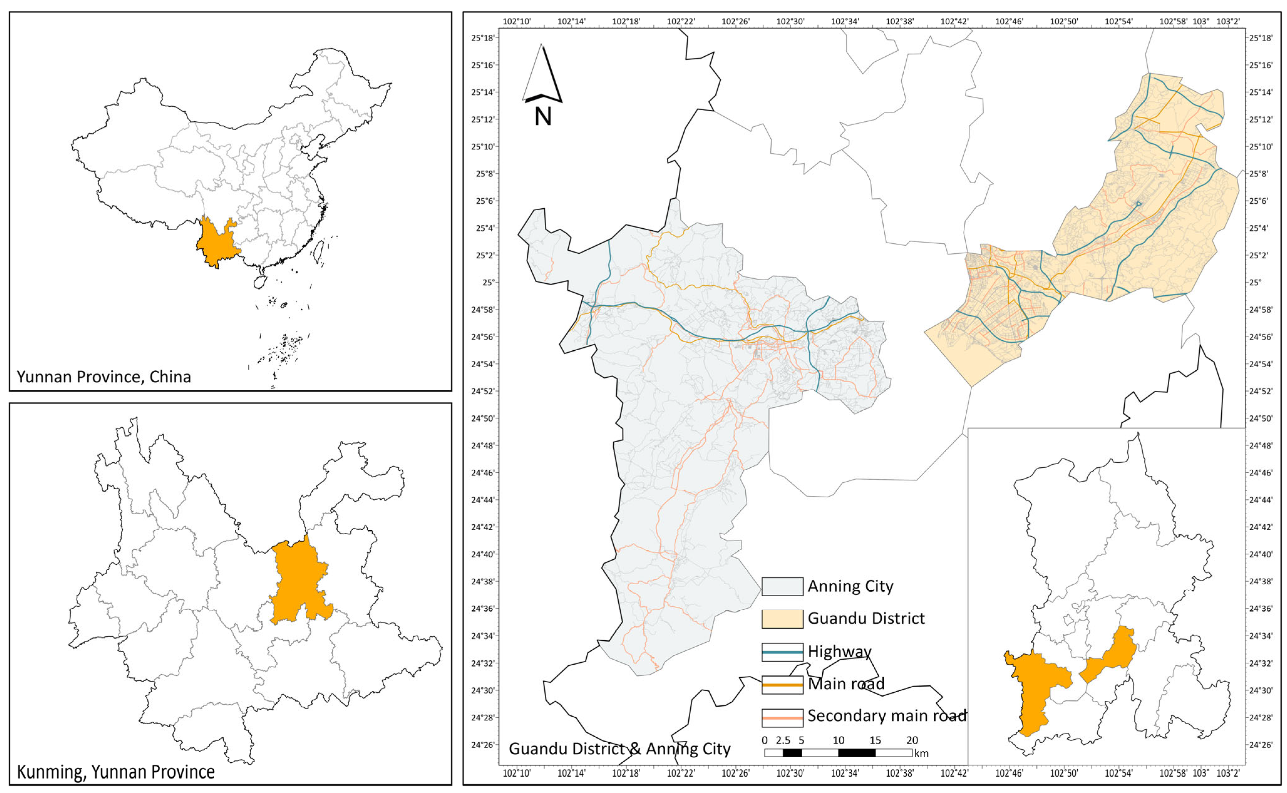
Figure 1. Location Map of the Study Area.
Buildings 15 02943 g001
Figure 2. Distribution Map of Urban Villages.
Buildings 15 02943 g002
Figure 3. Schematic Diagram of Boxplot.
Buildings 15 02943 g003
Figure 4. Boxplot analysis of urban village in Anning City.
Buildings 15 02943 g004
Figure 5. Outliers in Urban Villages of Anning City: (a) Wenquan Village; (b) Jile Village; and (c) Yuanshan Village.
Buildings 15 02943 g005
Figure 6. Radar chart analysis in Anning City.
Buildings 15 02943 g006
Figure 7. Boxplot analysis of urban village in Guandu District.
Buildings 15 02943 g007
Figure 8. Outliers of Urban Villages in Guandu District: (a) Guansuo Village; (b) Yongsheng Village; (c) Zijun Village; (d) Hongren Village; (e) Zhuyuan Village; and (f) Mingquan Village.
Buildings 15 02943 g008
Figure 9. Radar chart analysis of urban village in Guandu District.
Buildings 15 02943 g009
Figure 10. Boxplot analysis of urban village in Anning City and Guandu District.
Buildings 15 02943 g010
Figure 11. Radar chart analysis of urban village in Anning City and Guandu District.
Buildings 15 02943 g011
Figure 12. Correlation Analysis of Indicator-Level Data in Anning City.
Buildings 15 02943 g012
Figure 13. Correlation Analysis of Indicator-Level Data in Guandu District.
Buildings 15 02943 g013
Table 1. Classification of Urban Villages.
CategoryCriteria FulfillmentRegionQuantity
Core zones Central Urban VillagesMeet two or all three criteriaGuandu District34
Expansion zones Central Urban VillagesAnning City0
Core zones Sub-Center Urban VillagesMeet one criterionGuandu District32
Expansion zones Sub-Center Urban VillagesAnning City29
Core zones Peripheral Urban VillagesMeet none of the criteriaGuandu District14
Expansion zones Peripheral Urban VillagesAnning City31
Table 2. Urban Village Evaluation Indicators and Data Sources.
Evaluation DimensionAssessment FocusData SupportData Description and Processing Methods
Ecological EnvironmentAgricultural Development ResourcesAgricultural Land Area RatioReflects agricultural development level; Obtained through interviews and satellite imagery to calculate the ratio of agricultural land to collective land area.
Ecological Development ResourcesGreening Coverage RateMeasures ecological construction status; Acquired via drone aerial photography for village-wide high-resolution images. Evaluated using a five-point Likert scale (1–5) based on green coverage, with scores averaged by six researchers.
Spatial IntensityLand Use IntensityCollective Construction Land AreaReflects land development potential; Precise data obtained through village cadres’ interviews.
Homestead Area RatioReflects self-built housing intensity; Calculated as homestead area divided by collective construction land area (data from cadres’ interviews).
Building Space IntensityFloor Area Ratio (FAR)Quantifies total development scale; Scored 3, 2, or 1 based on policy thresholds: ≤1.5, 1.5–2, or ≥2.
Average Building storiesReflects vertical construction intensity; Determined via street view imagery and interview records.
Social ResilienceDemographic stabilityRegistered/permanent population ratioIndicates population inversion and governance challenges; Calculated from cadres’ interview data.
Permanent population sizeReflects population scale potential; Precise data from cadres’ interviews.
Basic service provisionPublic Service Facility CompletenessReflects basic living security; Field surveys record administrative, cultural, educational, sports, medical, commercial, and elderly care facilities (1 point per facility, max 7 points).
Municipal Infrastructure CompletenessReflects spatial carrying capacity; Field surveys evaluate road integrity, parking facilities, water supply, drainage, gas, and sanitation facilities (1 point per facility, max 7 points).
Economic VitalityResident Economic BasePer Capita IncomeReflects residents’ wealth level; Precise data from cadres’ interviews.
Collective Industrial IncomeReflects collective industrial development; Data from cadres’ interviews.
Industrial development qualityIndustrial Land AreaReflects industrial space potential; Precise data from cadres’ interviews.
Development Safety LevelReflects risk management capacity; Field surveys assess fire safety (fire exits, turnarounds, stations, hydrants, extinguishers, smoke detectors), public safety (shelters, emergency exits, pandemic pathways), and security (surveillance, streetlights, migrant population management). Scored 1 point per item, max 12 points.
Notes: 1. Likert Scale Application: Six trained researchers independently assessed greening coverage using a standardized 5-point Likert scale (1 = poorest, 5 = excellent). Inter-rater reliability analysis confirmed acceptable consistency (α > 0.80 threshold). 2. Safety Scoring System: Development safety integrates fire/public/security metrics with weighted scoring thresholds. 3. Data Collection Methods: Combines field surveys (e.g., infrastructure completeness), remote sensing (drone/satellite imagery), and participatory interviews (cadre consultations).
Table 3. Weighting System for Evaluation Framework.
Goal Level (O)Criterion Level (C)WeightSub-Criterion Level (SC)WeightIndicator Level(I)Weight
Comprehensive Development StatusEcological Environment0.18Agricultural Development Resources0.25Agricultural Land Area Ratio1
Ecological Development Resources0.75Greening Coverage Rate1
Spatial Intensity0.28Land Use Intensity0.67Collective Construction Land Area0.52
Homestead Area Ratio0.48
Building Space Intensity0.33Floor Area Ratio (FAR)0.38
Average Building stories0.62
Social Resilience0.19Demographic stability0.25Registered/permanent population ratio0.36
Permanent population size0.64
Basic service provision0.75Public Service Facility Completeness0.47
Municipal Infrastructure Completeness0.53
Economic Vitality0.35Resident Economic Base0.67Per Capita Income0.56
Collective Industrial Income0.44
Industrial development quality0.33Industrial Land Area0.38
Development Safety Level0.62
Table 4. Typological characteristics and governance strategies for urban villages in Kunming.
CategoryKey CharacteristicsGovernance ObjectivesRecommended Strategies
Core zones Central Urban Villages-High-density mixed-use development
-Adjacent to transit hubs
-Service overload from population inversion
-Land capitalization conflicts
-Occasional high-value agriculture
Achieve vertical spatial efficiency
Alleviate population pressure
Enable eco-economic synergy
1. TOD-oriented 3D development
2. Flexible land exchange mechanisms
3. Tiered service systems
4. Preservation of agricultural patches
Core Zone Sub-Center Urban Villages-Moderate accessibility
-Reduced land use conflicts
-Contiguous farmland preservation
Enhance living quality
Strengthen residential function
Promote moderate mixed-use
1. Functional retrofitting
2. Collective land consolidation
3. Agricultural corridor construction
4. Neighborhood service upgrades
Core Zone Peripheral Urban Villages-Highest social resilience
-Low redevelopment costs
-Homogeneous low-intensity development
Preserve social networks
Activate cultural capital
Develop peri-urban tourism
1. Incremental infrastructure upgrades
2. Craft workshop implantation
3. Farm market + eco-lodge development
Expansion Zone Sub-Center Urban Villages-Strong ecological base
-Low spatial efficiency
-“Weak overall, strong locally” economy
Protect ecological assets
Replicate success models
Unlock development potential
1. Mountain/farmland conservation
2. “Specialty resources + collective operations” model
3. Recreational space transformation
Expansion zones Peripheral Urban Villages-Superior underutilized ecology
-Agriculture-dominated economy
-Service deficiencies
Realize ecological value
Address service gaps
Ensure sustainable development
1. Digital agricultural chains
2. Carbon trading mechanisms
3. Mobile health/education services
4. Collective land consolidation
Disclaimer/Publisher’s Note: The statements, opinions and data contained in all publications are solely those of the individual author(s) and contributor(s) and not of MDPI and/or the editor(s). MDPI and/or the editor(s) disclaim responsibility for any injury to people or property resulting from any ideas, methods, instructions or products referred to in the content.