Article

Integrating AHP-Entropy and IPA Models for Strategic Rural Revitalization: A Case Study of Traditional Villages in Northeast China

1
School of Architecture and Urban Planning, Jilin Jianzhu University, Changchun 130118, China
2
Jilin Province Historical Building Protection and Utilization Research Base, Changchun 130118, China
*
Author to whom correspondence should be addressed.
Buildings 2025, 15(14), 2475; https://doi.org/10.3390/buildings15142475
Submission received: 18 June 2025 / Revised: 7 July 2025 / Accepted: 10 July 2025 / Published: 15 July 2025
(This article belongs to the Section Architectural Design, Urban Science, and Real Estate)

Abstract

Traditional villages are critical to preserving cultural heritage and promoting sustainable rural development. This study evaluates the development potential of 47 traditional villages in Jilin Province from the perspectives of spatial planning, architectural conservation, and rural real estate revitalization. A Development Potential Assessment (DPA) framework is constructed based on five dimensions: geographical position, cultural resources, socio-economic factors, natural ecology, and living environment. The AHP-entropy weighting method is applied to ensure objectivity in scoring, while kernel density analysis and coefficient of variation techniques identify spatial patterns and internal disparities. To further inform strategic planning and targeted investment, an Importance–Performance Analysis (IPA) model is introduced, aligning resource advantages with development performance. Key findings include the following: (1) significant spatial heterogeneity, with higher potential concentrated in the southeast and lower levels in the northwest; (2) cultural and socio-economic dimensions are the most influential factors in differentiating development types; and (3) a subset of villages shows a disconnect between resource endowment and realized potential, indicating the need for tailored design interventions and investment strategies. This research offers a visual and data-driven basis for differentiated revitalization strategies, integrating urban science methods, architectural thinking, and real estate development logic. It supports refined policy implementation, spatial design decisions, and the activation of underutilized rural assets through context-sensitive planning.

1. Introduction

Traditional villages play a significant role in transmitting historical and cultural legacy by preserving priceless historical data, cultural genes, and regional cultural traits with enduring social-historical memories [1]. The preservation and revitalization of traditional villages have emerged as critical components of both global cultural heritage protection and regional rural revitalization, particularly as the idea of heritage protection gains traction worldwide. However, in recent years, traditional villages have faced significant challenges, such as depopulation, functional degradation, and the loss of cultural assets, primarily due to urbanization, industrialization, and the large-scale migration of rural residents [2]. To achieve the sustainable revitalization and use of traditional villages, it is now crucial for government agencies and the academic community to effectively coordinate economic development and cultural preservation, based on preserving the villages’ cultural value.
The academic community has been studying traditional villages methodically for a long time, with research themes spanning several domains like social equality, cultural heritage, and tourism development, according to an assessment of the current status of international research [3]. Early studies primarily focused on the spatial organization of settlements, architectural preservation, and cultural legacy. Research has shown that sustainable tourism can benefit both the ecological environment and the cultural heritage of traditional villages, while fostering social cohesion and local economic growth [4]. Nonetheless, an overemphasis on tourism development has sometimes overlooked the needs of local communities, highlighting the importance of balancing village development with the requirements of the residents [5]. As a result, while tourism has often been discussed as a means of revitalizing traditional villages, its role as a long-term development strategy—particularly in terms of integrating tourism with village resources—has yet to be thoroughly examined.
The preservation and revival of traditional villages in China has been the subject of extensive research, which has produced a wealth of theoretical and practical investigations, especially in the fields of community building [6], cultural heritage [7], and tourism development [8]. Researchers generally agree that revitalization efforts should focus on local characteristics, with industry and population being key drivers, and culture and landscape serving as supporting factors. Various mechanisms must also be in place to support revitalization [9,10,11,12]. Additionally, current research has proposed the idea of “dual repair of settlements” regarding traditional village protection measures, which includes creating distinct protection pathways through ecology, culture, and economy [13]. The application of technologies like GIS and virtual reality has increasingly become a hot topic in the preservation of traditional villages, offering new tools for spatial planning and cultural resource management [14]. The region’s overall level of protection and management can be improved by using these technical tools to carry out spatial planning and cultural resource reproduction more effectively. In response to the difficulties of preservation during modernization, some studies have suggested encouraging the thorough conservation and sustainable growth of traditional villages through a varied and integrated governance model [15].
Despite these advancements, much of the existing domestic research on traditional village preservation has been protection-focused or centered on single-dimensional development models, particularly tourism. There remains a significant gap in the development of a multi-dimensional, comprehensive evaluation framework for revitalization, one that considers regional distinctions and local peculiarities. Current assessments often focus on conservation outcomes and UNESCO World Heritage nominations, but more research is needed to propose multi-faceted strategies for revitalization, usage, and activation [16]. In conclusion, more thorough studies on traditional communities are required. To successfully combine the preservation of traditional villages with regional sustainable development, a thorough analysis and evaluation of their development potential should be carried out from a more integrated perspective, especially by creating unique revitalization strategies that consider regional characteristics and multiple factors.
Jilin Province, located in Northeast China, is home to a diverse range of traditional villages that reflect the region’s distinctive architectural styles, folk culture, and ways of life [17]. These villages offer significant potential for preservation and development, particularly given their rich cultural heritage and historical value. However, research on the preservation and revitalization of traditional villages in Jilin Province has lagged behind other regions of China. Common challenges include inefficient resource allocation and a lack of enthusiasm for revitalization, which hinder the full utilization of these villages’ unique attributes. The choice of Jilin Province as a case study is based on its unique combination of cultural diversity, regional characteristics, and development challenges. The province’s traditional villages, many of which are home to ethnic minorities like the Korean and Manchu communities, present a distinctive context for exploring sustainable revitalization strategies. This study aims to address the existing research gaps by constructing a multi-dimensional Development Potential Assessment system. The study focuses on 47 traditional villages in Jilin Province, systematically analyzing their regional and spatial differentiation characteristics, and proposing targeted revitalization strategies based on the findings.
This study specifically addresses the following fundamental questions: How can the growth potential of traditional villages in Jilin Province be evaluated scientifically? In order to accommodate varying potential levels, how may specific revitalization and utilization strategies be suggested based on the evaluation results? This study has set the following particular goals to address these issues: (1) Establish a thorough and scientific system of indicators for the Development Potential Assessment (DPA). Geographical location, cultural resources, social and economic variables, natural and ecological elements, and residential environment are the five primary aspects of the DPA indicator system created for this study. (2) To do a regional difference study and assess the development potential of 47 traditional villages in Jilin Province. (3) To use the findings of the IPA analysis to provide focused and unique revitalization and utilization strategies.
To determine the comprehensive weights of the assessment indicator system, this study employs a combination of the Analytic Hierarchy Process (AHP) and the entropy method to integrate both subjective expert judgments and objective data. AHP allows for the systematic incorporation of expert opinions regarding factors like cultural values and community needs, which are difficult to quantify. However, to ensure the objectivity of the weighting process, the entropy method is applied to calculate the weights based on the variability of each indicator, providing a data-driven perspective that counterbalances the subjectivity inherent in expert assessments. This dual approach, combining subjective and objective elements, ensures a more balanced and robust evaluation framework.
Additionally, techniques such as the coefficient of variation method and kernel density analysis are used to analyze the spatial distribution and internal disparities of the development potential across the 47 villages. The coefficient of variation method highlights the variability and consistency in the data across different villages, revealing patterns of unequal resource distribution. On the other hand, kernel density analysis is applied to uncover the spatial patterns of development potential, identifying areas of high potential and regions in need of targeted intervention. These spatial techniques complement the weight assignment methods, providing a holistic view of the geographical spread and development potential across the study area.
Finally, Importance–Performance Analysis (IPA) is introduced to integrate both the importance and performance dimensions of each indicator. By comparing the relative importance of each factor with its actual performance, IPA enables the identification of areas where investment and strategic focus are most needed. This method allows for the alignment of resource advantages with actual development performance, ensuring that revitalization efforts are targeted effectively. Based on the comprehensive evaluation results from these methods, the study proposes operational and tailored revitalization and utilization strategies for the traditional villages in Jilin Province. These strategies are designed to address the specific strengths and weaknesses identified through the analysis, ensuring that interventions are context-sensitive and regionally appropriate.
The introduction, study methodology, findings analysis, discussion, and conclusions comprise the five main elements of the overall research framework. The study’s theoretical contribution is to enhance and broaden the scholarly theoretical framework in the area of traditional village preservation and regeneration. To effectively support the implementation of regional rural revitalization and sustainable development strategies, the practical contribution consists of offering specific and workable strategy proposals for preserving and revitalizing traditional villages in Jilin Province and the entire Northeast region.

2. Materials and Methods
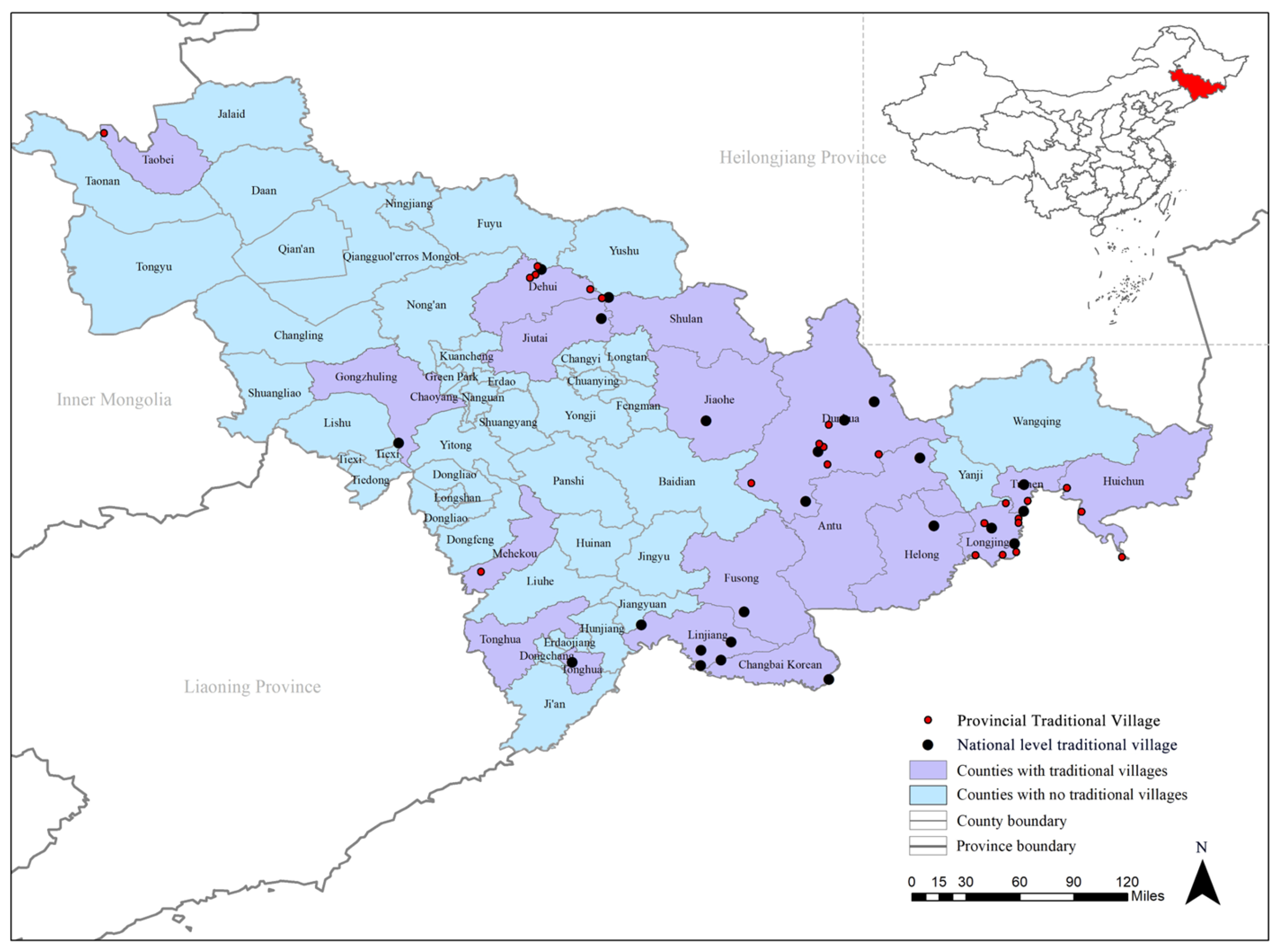
2.1. Study Area

Jilin Province is located in the northeastern part of China (124°33′ E~130°10′ E, 41°43′ N~46°19′ N), bordering Russia and North Korea, with a typical temperate monsoon climate. The province has distinct seasons, with cold, dry winters, warm, humid summers, and a rich variety of plant life, making it an ecologically diverse region. As the birthplace of Manchuria, Jilin Province has a rich cultural heritage, particularly in terms of Manchu culture and Northeast Chinese folk culture. This study focuses on traditional villages in Jilin Province, selecting 23 national-level and 24 provincial-level traditional villages within the province as research subjects (Figure 1). These villages are geographically distributed across diverse environments within the province, such as mountainous areas, plains, and regions surrounding rivers, lakes, and other water bodies. This selection was designed to ensure the sample represents the broad spectrum of geographical and environmental conditions present in Jilin Province.
The selection criteria for these 47 villages were based on their historical, cultural, and socio-economic significance. National-level traditional villages generally possess higher historical and cultural value, as well as more stringent architectural preservation standards. On the other hand, provincial-level villages are characterized by strong regional distinctiveness, reflecting the diverse heritage of the province. While they may not always receive the same level of policy support or recognition, provincial-level villages often harbor rich traditional cultural resources and face unique development challenges. By including both national and provincial-level villages, we ensure that the sample provides a comprehensive view of the varying conditions and challenges for traditional village revitalization across Jilin Province.

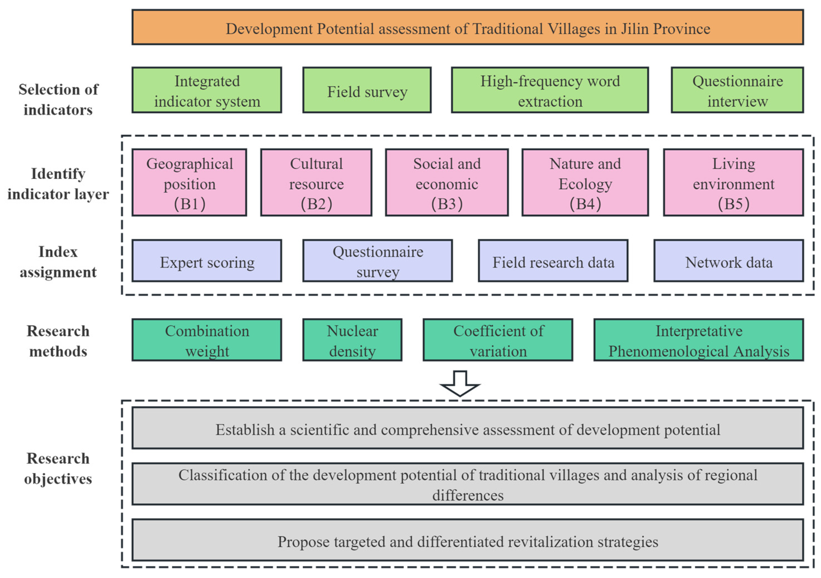
2.2. Data Sources and Research Framework

The data sources for traditional villages in this study are based on the list of traditional villages published by the Ministry of Housing and Urban-Rural Development of China [18] and the China Traditional Villages Network [19]. The geographic coordinates of the villages were obtained using the Gaode Maps coordinate picker, visualized using ArcGIS 10.2, and attributes were added. Government statistical data were obtained from the annual statistical bulletins published by the Jilin Provincial Bureau of Statistics and local governments [20], which include specific data on permanent residents, economic income, industrial structure, as well as other aspects of each village. In-depth interviews and questionnaire surveys were used in conjunction with on-site visits between April 2024 and March 2025 to gather field survey data. A total of 178 valid samples, comprising 13 interviews and 165 questionnaires, were obtained by the study team through the systematic collection of pertinent information by visiting villagers, local authorities, and specialists with substantial practical experience. The gathered questionnaire data were subjected to reliability analysis using SPSS 27.0 software, which produced a Cronbach’s α coefficient of 0.983, suggesting good scale reliability. In order to gather firsthand information on village architectural styles, cultural legacy, infrastructure, and villagers’ living situations, the research team carried out field surveys in several traditional villages in Jilin Province at the national and provincial levels. In-depth conversations with specialists in disciplines like sociology, architecture, cultural heritage preservation, urban and rural planning, and rural revitalization were used to gather data from expert interviews. The development of the study’s weighting settings, revival strategy formulation, and evaluation indicator system was all supported theoretically and practically by these specialists. Together, the four data types indicated above provide the study’s data basis, guaranteeing the assessment model’s scientific validity, thoroughness, and applicability.
This study developed a research framework that included “indicator system construction—development potential calculation—spatial structure analysis—type identification and strategy recommendations” (see Figure 2) based on the previously indicated multi-source data support.

2.3. Methods

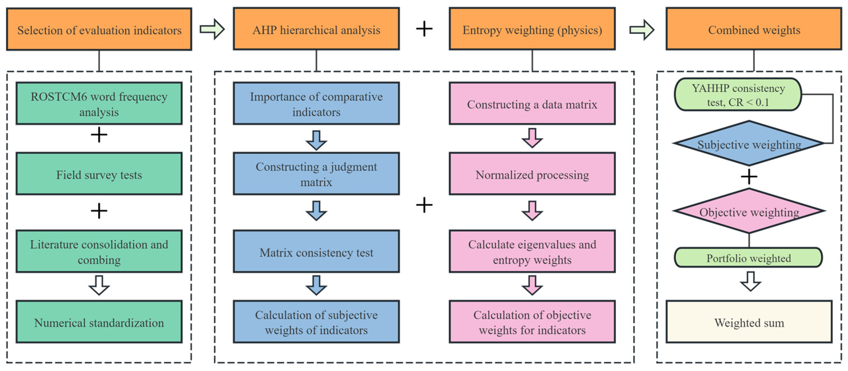
2.3.1. The Construction of DPA

  • Selection of indicators for assessing development potential
The thorough and scientific selection of evaluation indicators is the foundation for accurately estimating the growth potential of traditional villages. To ensure that the indicator system is comprehensive, scientific, and practical, this study heavily relies on previous research findings and indicator creation methodologies [21,22,23,24]. The selection of indicators is primarily based on the following four factors: (1) To create a foundational indicator database, we used ROST CM6 software to extract and analyze high-frequency terms from existing literature on the spatial characteristics and development potential of traditional villages; (2) to identify key factors with regional characteristics and practical significance, we conducted field surveys of several representative villages in Jilin Province; (3) to consolidate the evaluation framework by integrating data from the “Traditional Village Assessment and Identification Indicator System (Trial)” [25]; (4) to arrange interviews with scholars and experts in the fields of architecture, urban and rural planning, and heritage protection; and village committees to conduct preliminary village surveys to revise and validate the indicator system that was initially constructed.
Based on ensuring that the relevant influencing factors for the revitalization and utilization of traditional villages are comprehensively covered from multiple dimensions, a system structure comprising five primary indicators—geographical location, cultural resources, social and economic factors, natural and ecological factors, and living environment—was ultimately established (Table 1). Each primary dimension is further divided into several secondary indicators, totaling 24 indicators, which encompass both quantitative indicators that can be measured and qualitative indicators that require expert assessment. To address the absence of certain evaluation factors in existing research, this study appropriately supplemented and optimized some indicators. For example, new indicators such as “economic location” and “ethnic composition” were added to reflect the village’s supportive role in the regional economic landscape, cultural resource characteristics, and policy-driven advantages. The “planning authenticity” indicator was also introduced to capture the harmony between settlement form and natural topography. Furthermore, to enhance the operability of qualitative indicators, the research team clarified the criteria and scoring methods for indicators such as “consistency of built landscape” through expert interviews. This indicator system aligns with national policies on protecting and revitalizing traditional villages while fully reflecting the regional characteristics of traditional villages in Jilin Province. It is particularly suitable for assessing the development potential of mountainous, ethnic minority-inhabited, or ecologically sensitive villages. This system provides a solid theoretical foundation and structural support for subsequent weight calculations, comprehensive scoring, and IPA analysis.
2.
Determination of indicator weights for the DPA System
To improve the model’s accuracy and scientific rigor, our study used a comprehensive weighting methodology combining both subjective and objective methods (see Figure 3). Subjective weights were assigned using the Analytic Hierarchy Process (AHP), which involved a stepwise pairwise comparison and consistency testing of the indicator system by engaging subject-matter experts to assess the relative importance of each indicator. Concurrently, objective weights were determined using the entropy weight approach, which calculates each indicator’s contribution based on its data variability, thus ensuring an unbiased assessment. By carefully considering both subjective and objective weights, the comprehensive weights were established, successfully merging expert knowledge with the objective characteristics of the data.
This combination of AHP and entropy weight effectively integrates expert insights with empirical data, ensuring a balanced and comprehensive evaluation. While methods such as TOPSIS, grey relational analysis, and fuzzy comprehensive evaluation could also be applied, these methods tend to rely heavily on subjective judgments (e.g., TOPSIS) or impose more rigid assumptions (e.g., grey relational analysis). AHP-entropy was selected due to its flexibility in handling both qualitative and quantitative data, making it particularly suitable for evaluating the complex, multi-dimensional nature of traditional village development. This combination ensures that the methodology is scientifically rigorous, transparent, and well-suited to the study’s goals.
(1)
Determining subjective weights using the AHP method
To subjectively assign weights to the indications, a total of 30 participants—12 specialists from disciplines including urban–rural planning, architecture, cultural heritage preservation, sociology, and rural revitalization, as well as 18 permanent residents were invited. Pairwise assessments of the significance of evaluation indicators at the same level were part of the weighting procedure. With values of 9, 7, 5, 3, and 1 denoting absolutely important, very important, comparatively significant, slightly important, and equally important, respectively, the measuring scale was split into nine levels. Indicating intermediate importance levels between neighboring levels were values of 8, 6, 4, and 2. For this pairwise comparison, experts just need to identify the judgment data. The weighting data is then used to create a judgment matrix, which is then processed using YAHHP software for consistency testing to guarantee that CR < 0.1 and that the results are fair [26,27]. Lastly, the following formula is used to determine the subjective weights of the indicators:
w i = j = 1 n a i k 1 n
w i = w i i = 1 n w i
In the formula, w i is the square root vector; a i k is the scale value of the relative importance of the i -th indicator to the k -th indicator; w i is the subjective weight of the i -th indicator.
(2)
Objectively determining weights using the entropy method
The entropy weight method can optimize the weights obtained from the AHP and is a somewhat objective way to calculate indicator weights [28]. The aforementioned staff members were asked to reconsider the significance of the indications. An original data matrix was created using the entropy weight approach, and the extreme value standardization method was used to normalize the evaluation data [29,30,31]. Let i denote the number of villages (i = 1, 2, 3, …), and j is the number of indicators (j = 1, 2, 3, …), and x i j is the standardized value. Construct the decision matrix R, and finally calculate the indicator entropy value e j and obtain the entropy weight result ω j , with the calculation formula being
① Data standardization processing:
x i j = x i j min ( x j ) max ( x j ) min ( x j ) ( P o s i t i v e   i n d i c a t o r s )
x i j = max ( x j ) x i j max ( x j ) min ( x j ) ( N e g a t i v e   i n d i c a t o r )
② Calculate the proportion P i j of village i under indicator j:
P i j = x i j α i x i j
③ Calculate the entropy value of the j-th indicator:
e j = i P i j ln ( P i j ) ln ( m n )
④ Calculate indicator weights:
w j = 1 e j j 1 e j
Among all evaluation indicators, distance from the urban center (C1), distance from the nearest transportation hub (C3), population aging (C12), population hollowing (C13), and natural disaster hazards (C19) are negative indicators, while the rest are positive indicators.
(3)
Determination of combination weights
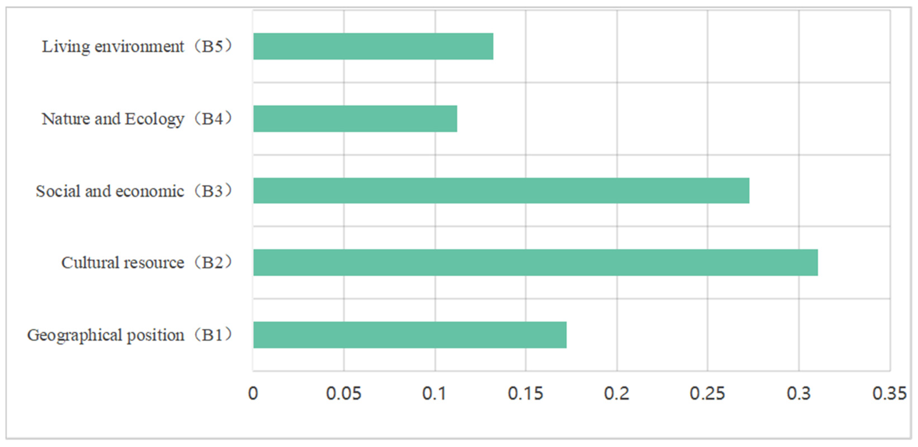
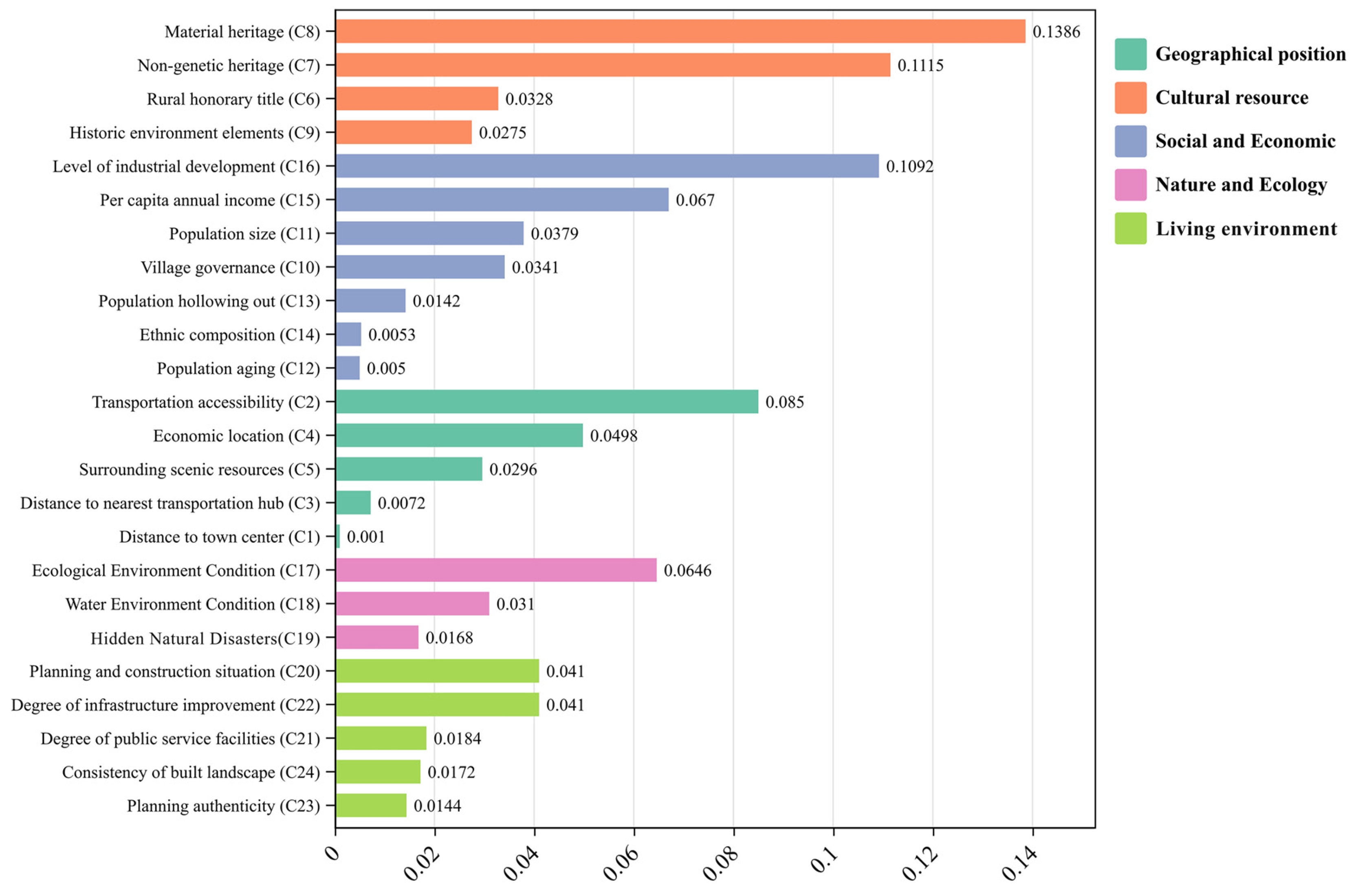
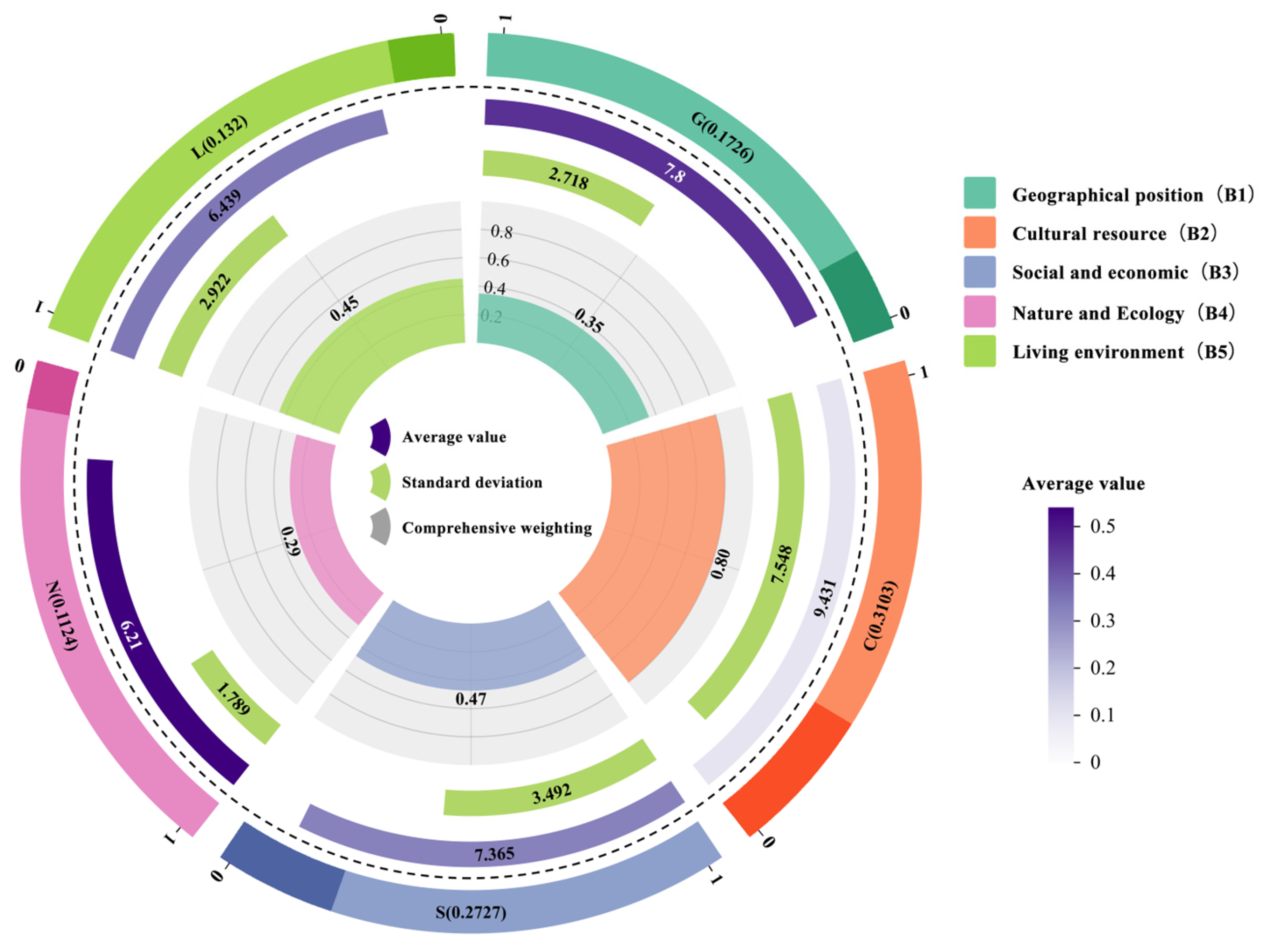
After calculating the subjective and objective weights using the AHP method and entropy weight method, respectively, the final combined weighting of the indicators is obtained using the following formula (see Table 2):
w j = w i w j j = 1 n w i w j
In the formula, w i is the subjective weight obtained by the AHP method; w j is the objective weight obtained by the entropy method.
Table 2. Weighting results for traditional village Development Potential Assessment indicators.
Target Layer AGuideline Layer BCombined WeightingUnit AttributesEvaluation Layer CAHP WeightingEntropy WeightCombined WeightingRank
Development Potential Assessment of Traditional Villages in Jilin Province (A)Geographical Position (B1)0.1726km/−Distance from urban center (C1)0.03190.00130.001024
Assignment/+Transportation accessibility (C2)0.09220.03910.08504
Person/−Distance from nearest transportation hub (C3)0.04100.00740.007221
Assignment/+Economic location (C4)0.06670.03170.04987
n/+Surrounding scenic resources (C5)0.01830.06870.029614
Cultural Resource (B2)0.3103Assignment/+Rural honorary titles (C6)0.03580.03890.032812
Assignment/+Intangible cultural heritage transmission (C7)0.06160.07680.11152
Assignment/+Tangible cultural heritage (C8)0.10350.05680.13861
n/+Historical environmental elements (ancient trees, wells, ancient bridges, etc.) (C9)0.02130.05470.027515
Social and Economic (B3)0.2727Qualitative/+Village-level governance (C10)0.03240.04470.034111
Person/+Population size (C11)0.02160.07450.037910
%/−Population aging (C12)0.01260.01670.005023
%/−Population hollowing out (C13)0.01250.04810.014220
Assignment/+Ethnic composition (C14)0.00680.03310.005322
CNY/+Per capita annual income (C15)0.04540.06260.06705
CNY/+Level of industrial development (C16)0.06590.07030.10923
Nature and Ecology (B4)0.1124Assignment/+Ecological environment status (C17)0.09750.02810.06466
Assignment/+Water environment status (C18)0.05600.02350.031013
Assignment/−Natural disaster risks (C19)0.02150.03320.016818
Living Environment (B5)0.1320Qualitative/+Planning and construction status (C20)0.05880.02960.04109
Assignment/+Public service facility coverage (C21)0.02370.03300.018416
Assignment/+Infrastructure completeness (C22)0.03890.04470.04108
Qualitative/+Planning Authenticity (C23)0.01250.04880.014419
Qualitative/+Consistency of Built Landscape (C24)0.02170.03370.017217

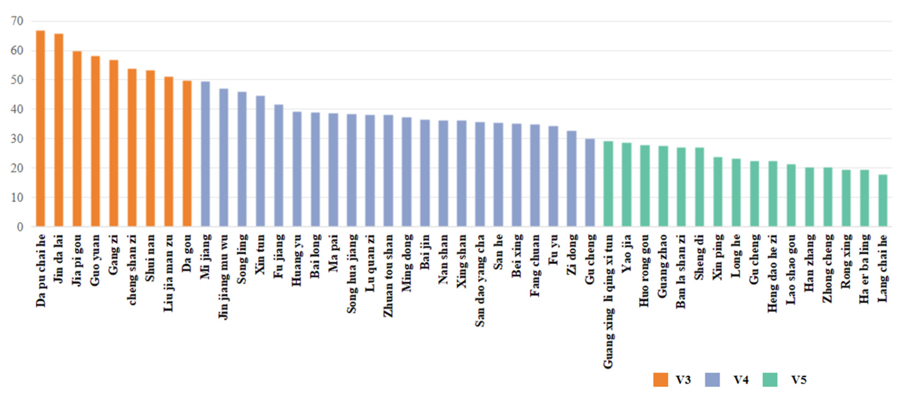
2.3.2. Classification of Village Development Potential and Multi-Factor Weighted Sum

This study refers to relevant literature [21] and combines the basic requirements for traditional village development with the score breakpoint theory and specific conditions, such as the number and type of evaluation objects, to classify the development potential of traditional villages in the region (Table 3). Calculations are made using the widely used weighted sum model, and the procedure is as follows:
D P A = j = 1 n x i j w j
DPA is the formula’s all-inclusive index for evaluating villages’ potential for development, x i j is the standardized value of indicator j for village i, w j is the weight value of indicator j, and n is the number of villages participating in the assessment. The larger the value of DPA, the greater the development potential of village i.
Table 3. Traditional Village Development Potential Classification.
NO.Potential IndexLevelPolicy Recommendations
V180 ≤ DPA ≤ 100High potentialConsolidate strengths and accelerate development
V270 ≤ DPA < 80Moderate potentialCultivate new momentum and gather strength
V350 ≤ DPA < 70Average potentialTap potential and lay a solid foundation
V430 ≤ DPA < 50Low potentialMaintain the status quo and improve people’s livelihoods
V5DPA < 30Very low potentialRelocate and consolidate

2.3.3. Coefficient of Variation Method

The coefficient of variation (CV) is a metric that can partially reflect the spatial disparities in the development potential levels of traditional villages [32]. It is applicable when the mean is not zero and can be employed to analyze regional differences. The CV is calculated by dividing the standard deviation of all data by the mean of all data. The more pronounced the differences and the greater the dispersion, the larger the calculated value; conversely, the smaller the value, the less pronounced the differences and the smaller the dispersion. The coefficient of variation is determined using the following formula:
c v = σ μ × 100
In the formula, c v is the coefficient of variation, σ is the standard deviation of the data, and μ is the mean value of the data.

2.3.4. Kernel Density Analysis Method

Density maps were generated using ArcGIS kernel density analysis for 47 sample datasets. Kernel density analysis is capable of determining the density of point or line features in the immediate vicinity. The concentration and distribution status of spatial point data are obtained by generating a continuous surface from discrete point data in space through formula calculations [33,34]. The kernel density calculation formula is as follows:
f ( x , y ) = 1 n h 2 j = 1 n k ( d i n )
In the formula, n is the number of samples; h is the search bandwidth; k is the kernel function; d is the spatial distance to sample i; and f ( x , y ) is the kernel density estimate value of coordinate point ( x , y ) . Using ArcGIS, the development potential levels of traditional villages were transferred to their attribute tables. Kernel density mapping was performed according to each dimension to visualize the spatial distribution of traditional villages [35]. In this study, the five dimensions were each divided into five levels using the natural breakpoint method, with darker colors in the map indicating higher levels of dynamic development.

2.3.5. Interpretative Phenomenological Analysis Method

IPA (interpretative phenomenological analysis) originated in the field of psychology, where it was mainly used to analyze individuals’ understanding and interpretation of their experiences [36]. In recent years, this method has been gradually introduced into research on urban–rural planning and rural development. As a two-dimensional analysis tool that combines subjective importance and objective performance, it has been widely used in resource assessment and development strategy identification [21]. Its core idea is to reveal the spatial distribution and potential characteristics of the research object in different dimensions through a two-dimensional “importance–performance” matrix, thereby assisting scientific decision-making.
We chose the IPA model for its clear strengths in evaluating complex, multi-dimensional data, making it particularly suitable for traditional village revitalization. The model allows us to focus on both the current resource status and the development potential, providing a comprehensive view that can guide targeted revitalization efforts. While other strategic models, such as SWOT or PEST, are useful for general assessments, IPA’s unique advantage lies in its two-dimensional focus on both the importance of factors and their actual performance, allowing for precise identification of areas requiring intervention. In contrast, SWOT analysis identifies broad categories of strengths and weaknesses but lacks the specificity and prioritization provided by IPA. PEST focuses on macro-environmental factors but does not address the operational dimensions of resource allocation and performance evaluation as effectively as IPA. Thus, IPA not only offers a systematic and quantifiable approach to evaluating traditional village development but also ensures that interventions are based on clear, actionable data that can drive effective decision-making.
This study utilizes the IPA analysis framework (Figure 4) to introduce a two-dimensional evaluation model that utilizes the “development potential score” and “current resource score” as coordinate axes in the Development Potential Assessment of 47 traditional villages in Jilin Province. The X-axis represents the village’s current resource score, which indicates the village’s actual resource endowment and basic conditions in terms of geographical position, social and economic conditions, ecological environment, and living environment. The Y-axis, on the other hand, is the development potential score, which is designed to evaluate the village’s future development space in terms of cultural value exploration, intangible cultural heritage inheritance, tourism linkage development, and spatial upgrading potential. This model allows for the visualization and strategic guidance of village typology structure, resource advantages, development shortcomings, and key areas for improvement by categorizing sample villages into four quadrants.

3. Results

3.1. Overall Assessment Results

3.1.1. Combined Weight Analysis of Evaluation Indicators

The combined weighting rankings of the five guideline layer indicators (Figure 5) in the Jilin Province Traditional Village Development Potential Assessment System constructed in this study are as follows: Cultural resources (B2) 0.3103, Social and economic (B3) 0.2727, Geographical position (B1) 0.1726, Living environment (B5) 0.1320, and Nature and Ecology (B4) 0.1124. This finding indicates that cultural heritage, which embodies the fundamental value of traditional villages, is a significant factor in the Development Potential Assessment as a whole. This is particularly true in the context of intangible cultural heritage inheritance, material heritage preservation, and historical environment factors, which significantly influence the uniqueness and appeal of rural areas. The endogenous development capacity and economic vitality of villages are significant supports for the current rural revitalization, as evidenced by the socio-economic factors “Level of industrial development” (C16, weight 0.1092) and “Per capita annual income” (C15, weight 0.0670).
The top three items with the highest weight values at the evaluation layer indicators level (Figure 6 and Figure 7) are “Tangible cultural heritage” (C8, weight 0.1386), “Intangible cultural heritage transmission” (C7, weight 0.1115), and “Level of industrial development” (C16, weight 0.1092). Furthermore, the “Ecological environment status” (C17, weight 0.0646) and “Transportation accessibility” (C2, weight 0.0850) also exhibit substantial influence, illustrating the fundamental role of ecological foundations and resource accessibility in the sustainable development of villages. In contrast, specific indicators related to social structure, such as “Population aging” (C12, weight 0.0050) and “Ethnic composition” (C14, weight 0.0053), as well as indicators related to natural environment constraints, such as “Natural disaster risks” (C19, weight 0.0168), have relatively low weights. This suggests that their influence is relatively limited in the overall Development Potential Assessment at the regional scale, but they are still of reference value in specific regional contexts or thematic studies.

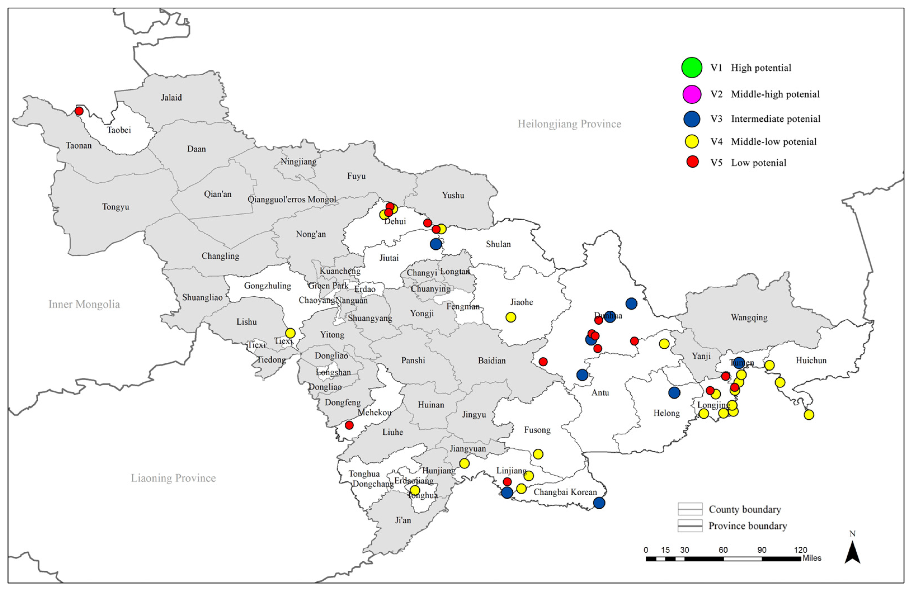
3.1.2. Rating of the Development Potential of Traditional Villages in Jilin Province

The 47 traditional villages in Jilin Province were classified into five tiers based on their development potential scores. The findings suggest that the overall development potential is relatively limited. The V3 (average, 50–70 points) and V4 (low potential, 30–50 points) tiers are the most concentrated, with an approximate 27.66% and 42.55% concentration, respectively. The V5 (very low potential, <30 points) tier contains 13 villages, accounting for 27.66%. The V1 (high potential, ≥80 points) and V2 (moderately high potential, 70–80 points) categories were absent, suggesting that the overall development potential of traditional villages in Jilin Province is restricted.
In the southeastern region of the province or along the China–North Korea border, villages with higher scores, including Jindalae Village in Helong City (66.01), Dapu Chaihe Village in Dunhua City (67.04), and Jiapi Gou Village in Linjiang City (60.09), are primarily situated in the Changbai Mountain region. These regions are typically endowed with a plethora of natural resources, a profound cultural heritage, a strong foundation for tourism development, and advantages in ethnic-specific industries. It is important to note that various municipalities in Dunhua City are concentrated in the V3 category, which serves as a relatively prominent regional “high ground” in the province. In contrast, the V5 villages with the lowest scores, including Langchaihe Village (18.16), Halbalin Village (19.71), and Rongxing Village (19.72), are primarily located in the northern outskirts of Dunhua City or remote rural areas of western Jilin Province. These villages are hampered by various factors, including remote locations, underdeveloped infrastructure, and insufficient resource endowments, which result in an extremely limited development potential.
The overall development potential of national-level traditional villages in Jilin Province is generally greater than that of provincial-level villages (Figure 8), primarily due to policy support and resource advantages. This is reflected in the recognition level. Nevertheless, there are a few exceptions, such as the provincial-level village of Dapu Chaihe in Dunhua City, which has a development potential score that surpasses that of certain national-level villages. This is indicative of the village’s favorable location and strong development foundation. Simultaneously, certain national-level villages exhibit lower development potential scores than provincial-level villages as a result of their remote geographical location and inadequate supporting facilities.
The development potential of traditional villages in Jilin Province is characterized by a typical “high in the southeast, low in the northwest” pattern from a spatial distribution perspective (Figure 9). The southeastern border mountainous regions, with their exceptional ecological environment and distinctive folk culture, have the potential to integrate tourism resources, thereby establishing local development highlights. Conversely, the western and northwestern regions are generally devoid of industrial support and cultural appeal, with villages confronting the dual challenges of “aging” and “hollowing out.”

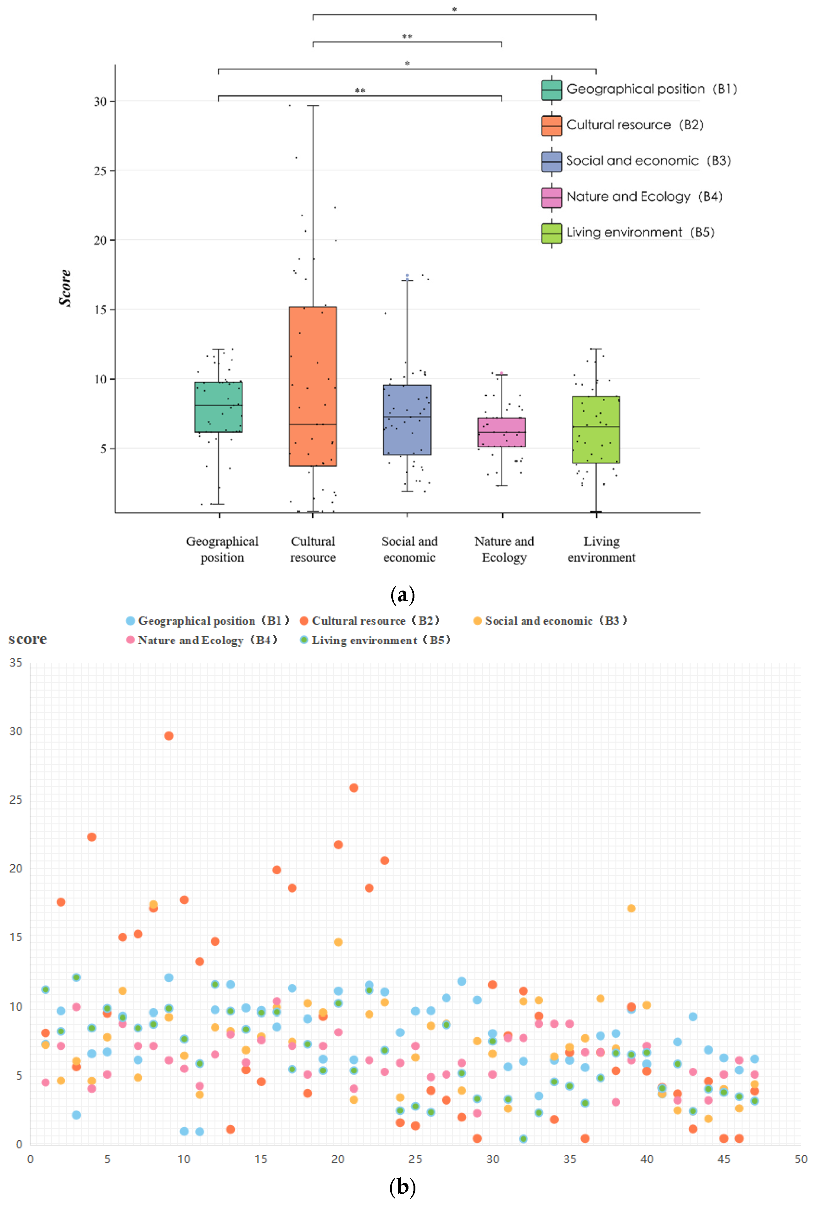
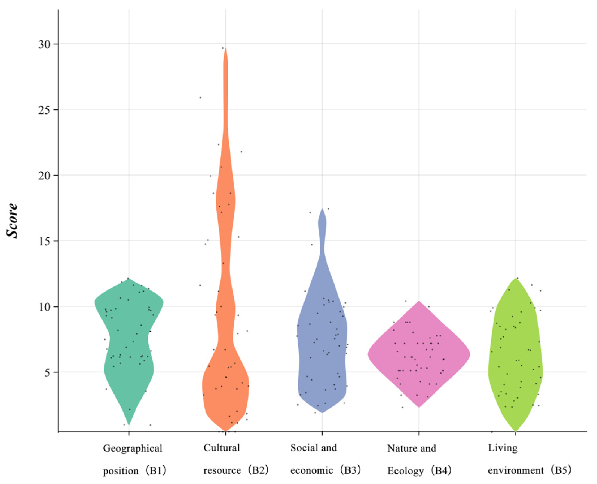
3.1.3. Multi-Dimensional Analysis

The development potential of traditional villages in Jilin Province is evaluated in this study using five dimensions. The distribution characteristics and differences of the scores in each dimension are revealed through the statistical analysis of the scores of 47 villages, in conjunction with box plots and scatter plots for visualization (Figure 10). Geographical position (B1) scores were generally low, with only a handful of villages demonstrating substantial advantages. This indicates that the majority of villages have limited development potential as a result of their geographical location. Cultural resource dispersion (B2) was greater, with some villages scoring highly due to their extensive historical and cultural resources, while others lacked cultural resources. The social and economic dimension (B3) scores were relatively balanced; however, villages with low scores demonstrated challenges in terms of inadequate social facilities and fragile economic foundations. The scores for nature and ecology (B4) were primarily at a medium level, suggesting that the majority of villages possess satisfactory ecological resources; however, some villages may be at risk of environmental degradation. The scores for living environment (B5) were relatively balanced, indicating that the majority of villages have relatively superior infrastructure and living conditions. However, there are still isolated villages with insufficient infrastructure.

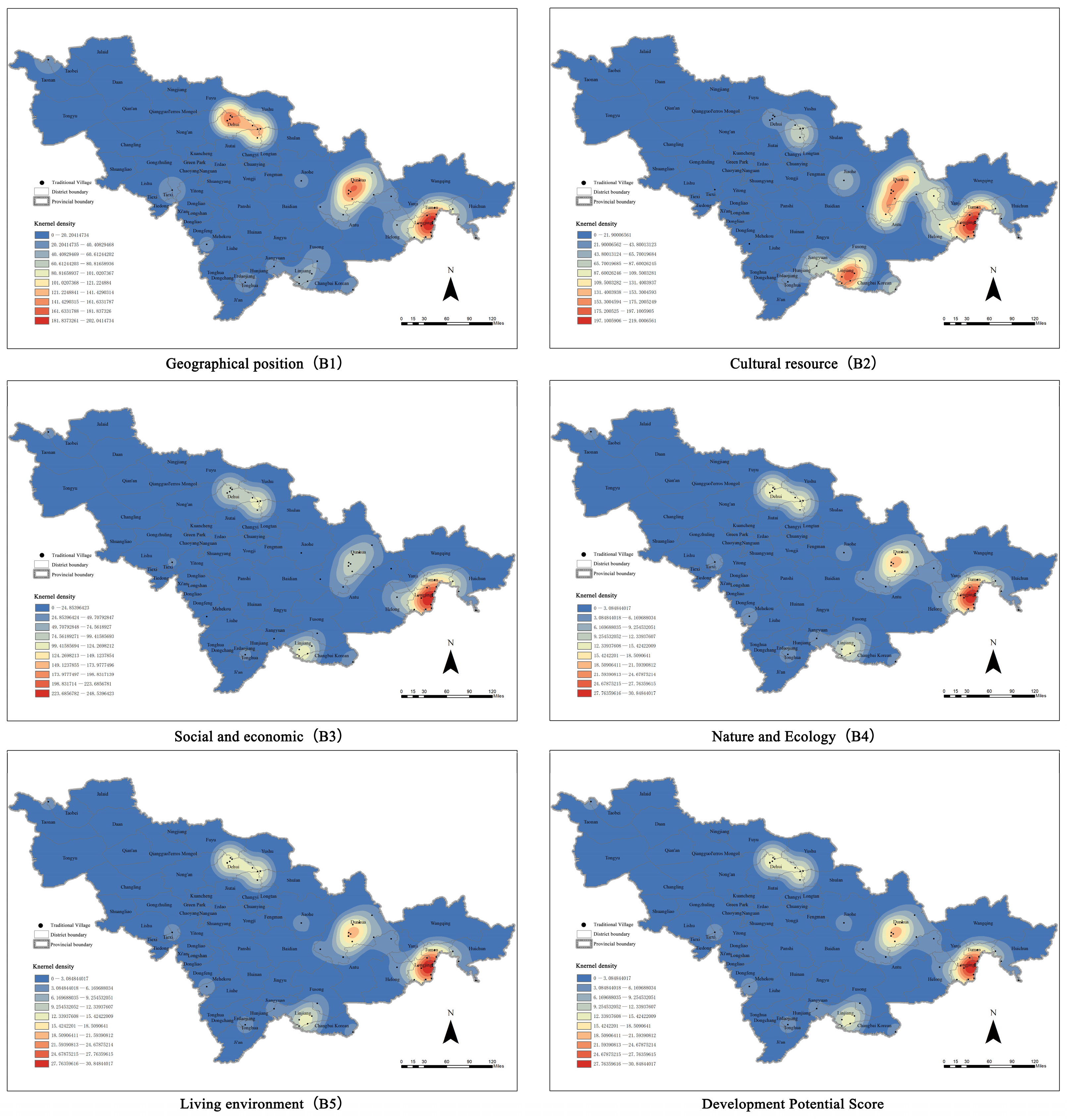
3.2. Kernel Density Analysis

Using multi-dimensional kernel density analysis (Figure 11) in ArcGIS, this study evaluated the development potential of 47 traditional villages in Jilin Province across five dimensions. The findings demonstrated that, despite the general similarity of the kernel density distributions for each dimension, there were still some distinctions in the details. The kernel density map of geographical position (B1) indicates that the southeastern region of Jilin Province and certain border areas are the primary concentrations of high-value areas. Geographical advantages are frequently conferred upon these localities by their proximity to border nodes or convenient transportation. Cultural resource (B2) exhibits relatively scattered high-density patches, which are notably prominent in the eastern mountainous areas and the Yanbian area. This suggests that this region’s historical and cultural heritage is relatively concentrated. The central and southern regions of the social and economic (B3) kernel density map are characterized by the concentration of hot spots, which indicates the relative advantages of villages in these regions regarding economic foundation and social services. Conversely, the distribution of high-value areas in nature and ecology (B4) is more evenly distributed, particularly in the western foot of Changbai Mountain and the eastern mountainous region. This suggests that traditional villages in Jilin Province are relatively balanced in terms of natural resource endowment; however, individual ecologically advantageous areas still exhibit significant agglomeration. The central hilly regions and the vicinity of transportation centers are the primary locations of the kernel density hotspots for the living environment (B5). This indicates that the infrastructure conditions and living quality are superior in these regions. The final comprehensive development potential kernel density map clearly demonstrates a high-value corridor that extends from the central to the southeastern region of the province. This demonstrates that these areas have substantial comprehensive development advantages in multiple dimensions and are potential clusters for future development in Jilin Province’s traditional villages.
In conclusion, kernel density analysis effectively exposes the spatial heterogeneity of traditional villages in Jilin Province in terms of five core dimensions and comprehensive development potential. Despite the fact that certain high-value areas are overlapping in multiple dimensions, the development advantages reflected in each dimension are not entirely consistent. This suggests that various villages should adapt to local conditions and emphasize their advantages in their developing paths.

3.3. Regional Differences Analysis

This study employs the coefficient of variation (CV) to conduct a quantitative analysis of the scores for the five primary indicators (Figure 12) to further disclose the spatial variability in the development potential of traditional villages in Jilin Province. Based on the analysis results (Table 4), the coefficient of variation for cultural resources (B2) was the highest among the five dimensions, reaching 0.800. This suggests that the disparities in cultural resource endowments between villages were the most important. The cultural resources of the majority of villages are comparatively scarce, with a highly uneven spatial distribution, while a small number of villages are concentrated with a wealth of intangible cultural heritage and historical traditions. The following dimensions are social and economic (B3) and living environment (B5), with coefficients of variation of 0.474 and 0.454, respectively. These dimensions also exhibit a moderate degree of spatial imbalance, which indicates the clear hierarchical differences in the economic base and living conditions of traditional villages.
In contrast, the coefficient of variation for geographical position (B1) is 0.349, suggesting that the geographical conditions of the majority of villages are similar, with only a small number of villages possessing exceptional locational advantages. The coefficient of variation for the nature and ecology (B4) dimension is the lowest, at a mere 0.288. This suggests that the spatial distribution of villages in terms of the ecological environment is relatively balanced, and that ecological resource advantages are relatively universal. In general, traditional villages in Jilin Province exhibit the most substantial spatial disparities in cultural resources and socio-economics, while ecological and geographical variables are relatively evenly distributed.

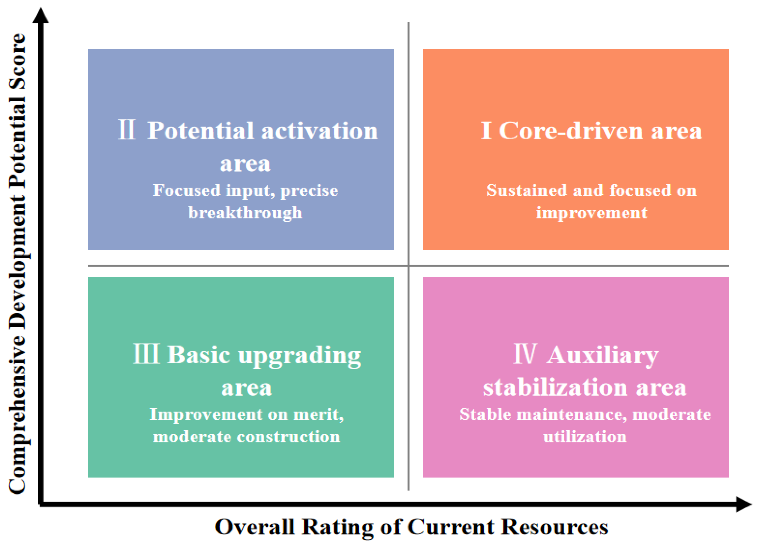
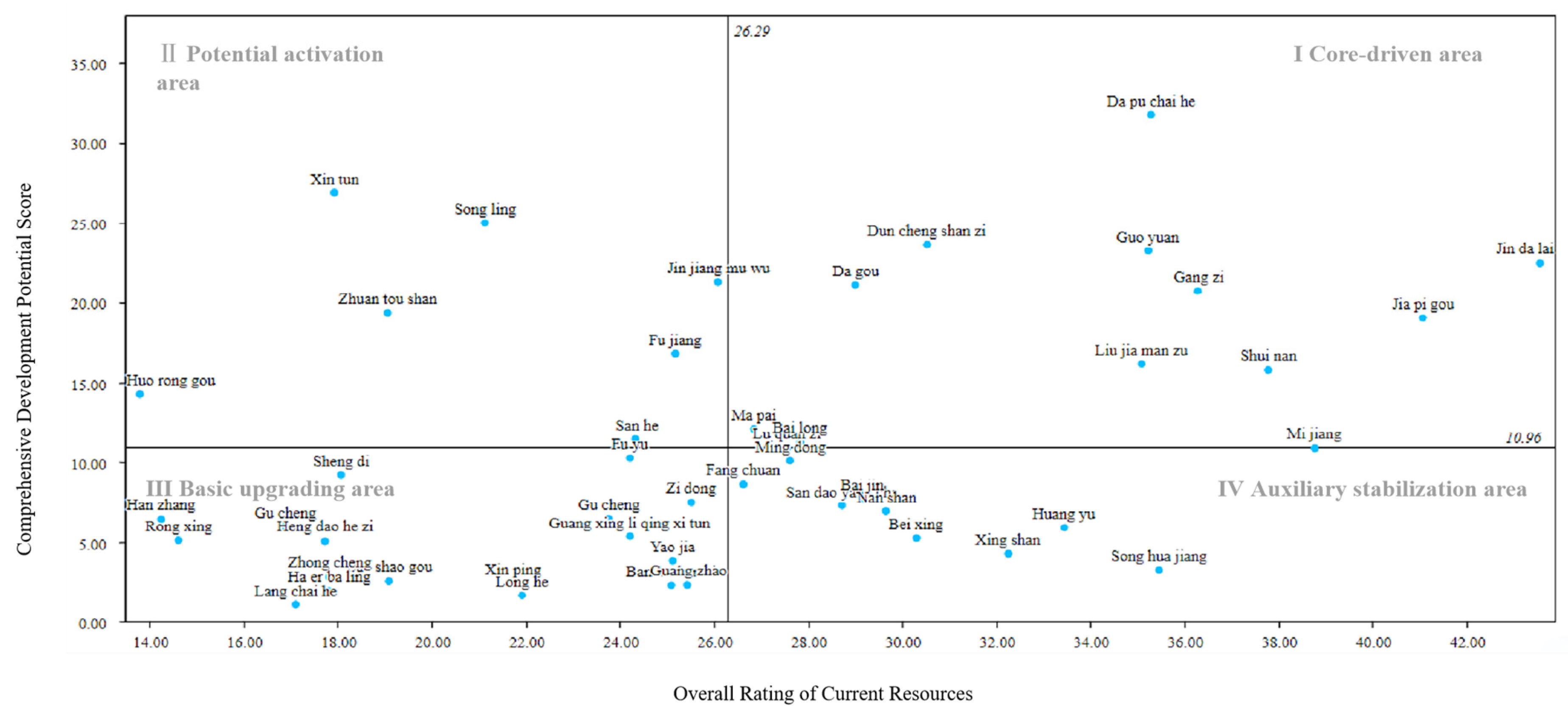
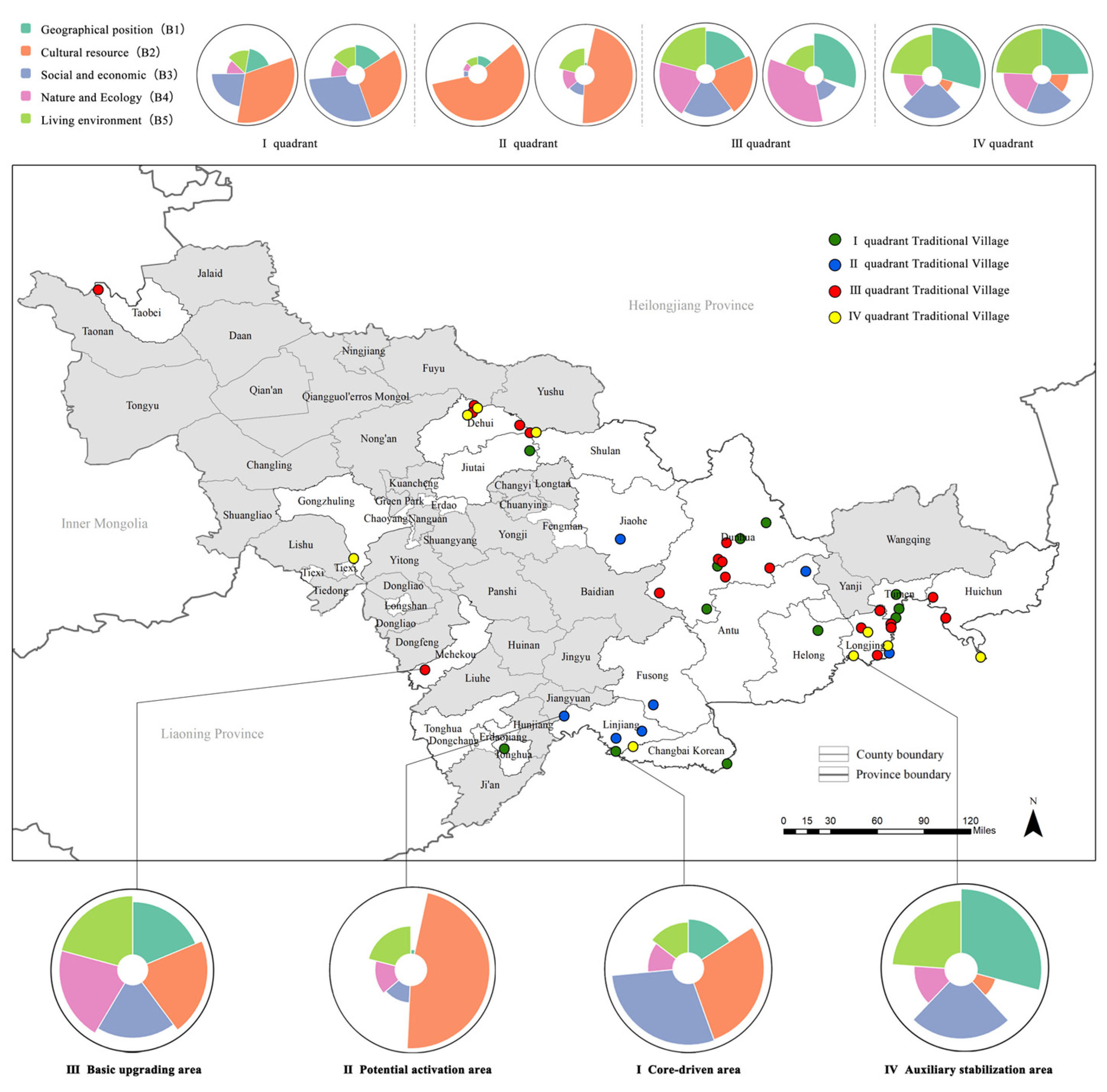
3.4. Importance Performance Analysis (IPA)

3.4.1. Presentation of IPA Analysis Quadrant Results

This study employs IPA diagrams to visually represent a comprehensive analysis of the current resources and development potential of traditional villages, as indicated by the aforementioned data and analysis results (Figure 13). The X-axis represents the current resource score, which reflects the village’s actual resource endowment and fundamental conditions in terms of geographical position, social and economic conditions, ecological environment, and living environment. The Y-axis represents the development potential score, which is designed to quantify the village’s future development space in terms of cultural value exploration, intangible cultural heritage inheritance, tourism linkage development, and spatial upgrading potential. Following the elimination of the highest and lowest values, the intersection point is determined by the average value (10.96, 26.29). The core propulsion zone, potential activation zone, foundation enhancement zone, and auxiliary stabilization zone are the four quadrants into which the entire coordinate system is divided. Each quadrant represents distinct combinations of future development potential and resource advantages, thereby facilitating the identification of the characteristics and development orientations of various village types. Table 5 summarizes the fundamental attributes of each quadrant.

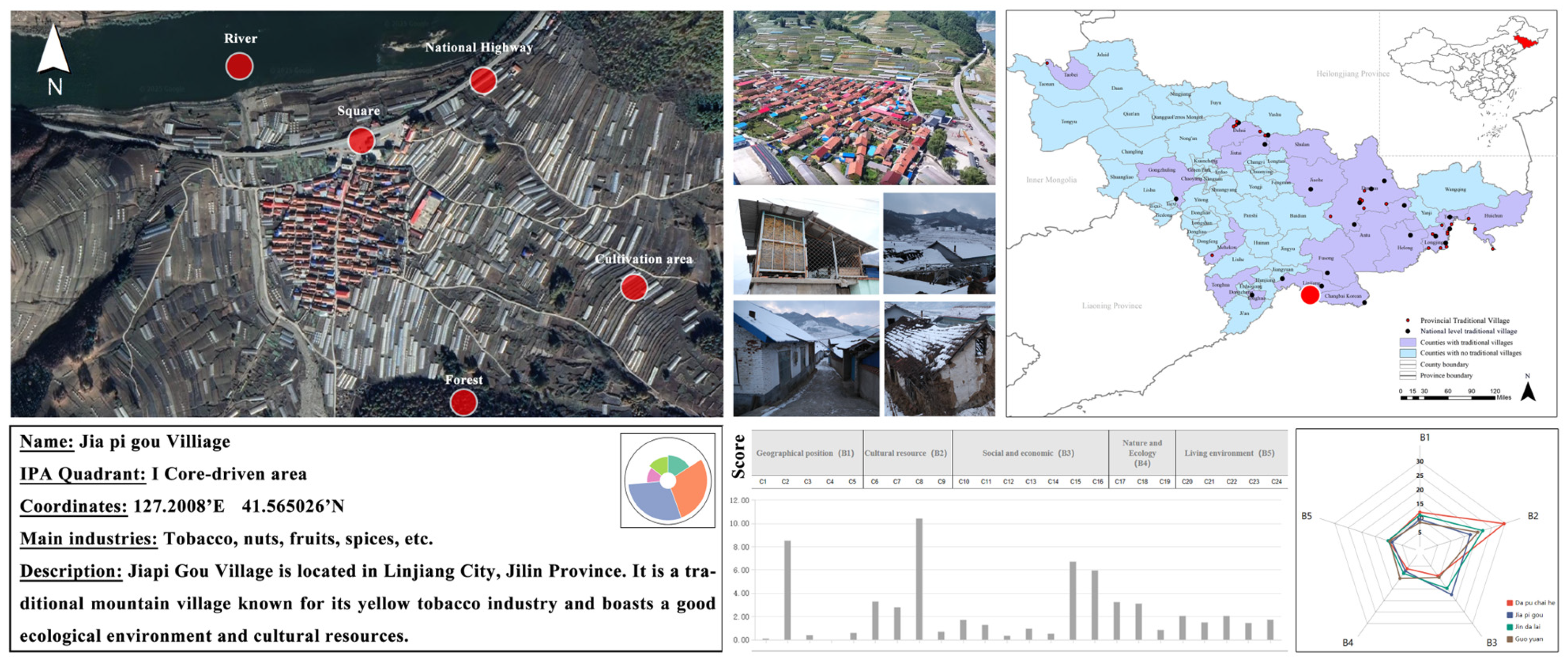
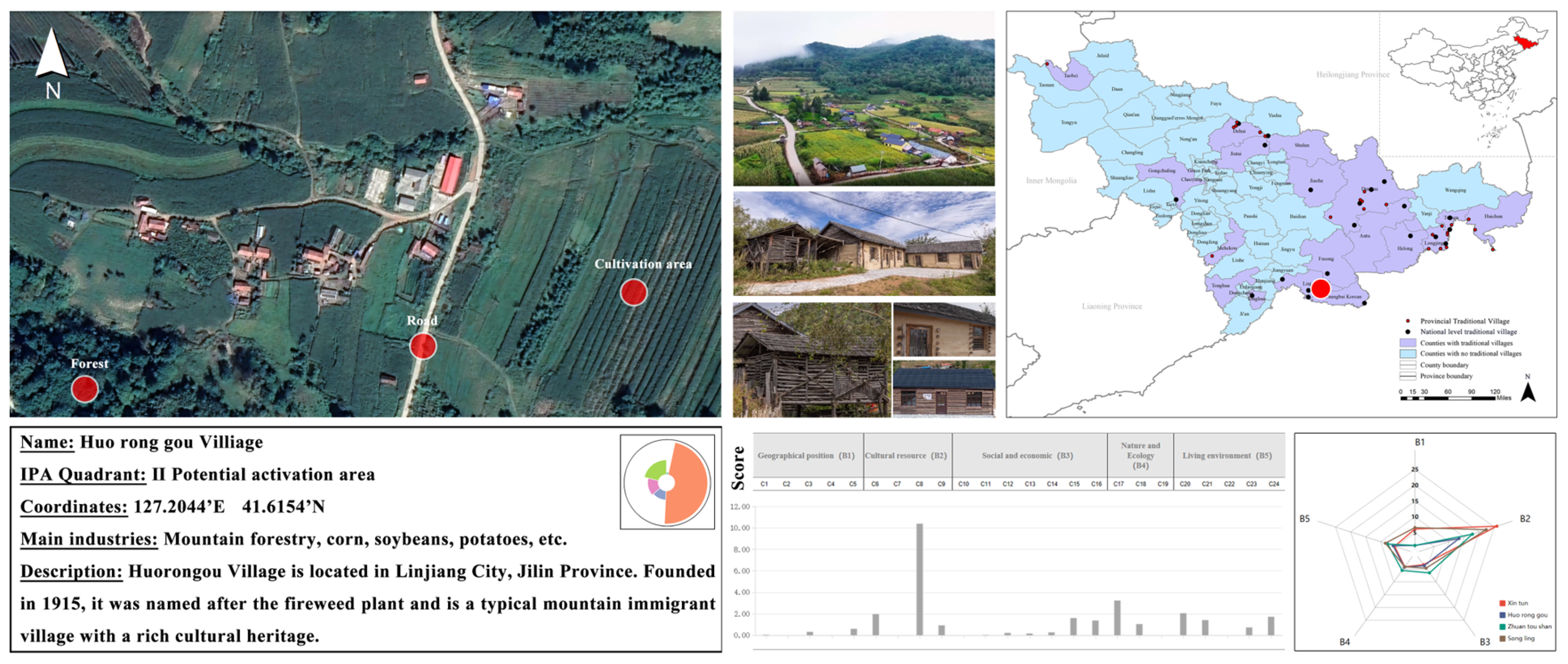
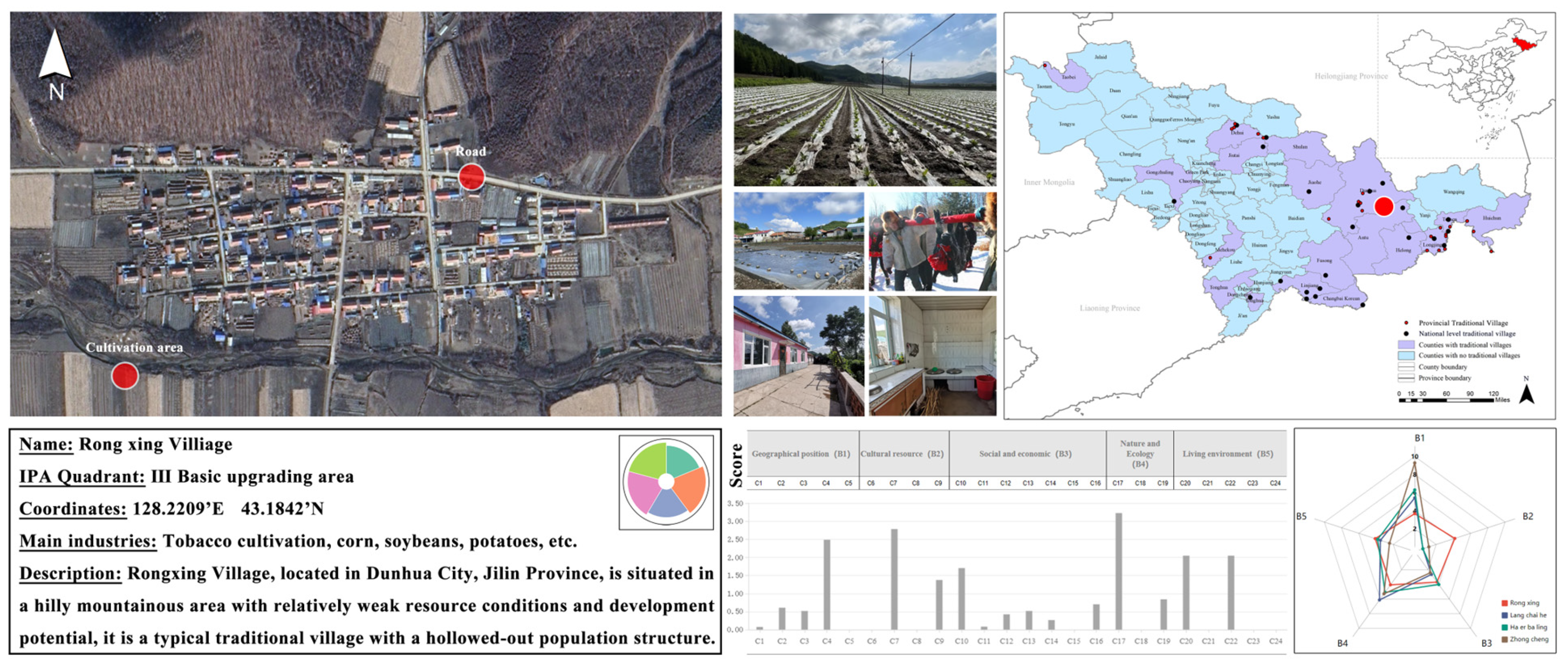
3.4.2. Analysis of Resources and Potential of Representative Villages in Different Quadrants

In order to conduct a more thorough examination of the differences in resources and development potential between traditional villages in Jilin Province, this study selected a few representative villages from each of the four IPA quadrants (Figure 14). We can gain a more comprehensive understanding of the strengths and weaknesses of each village by comparing its current resource scores to its development potential scores. This will enable us to devise strategies to revitalize the village.
(a)
First Quadrant: Jiapi Gou Village
Jiapi Gou Village exhibits the synergistic characteristics of “abundant resources–significant potential” (Figure 15). It scored high in the cultural resources dimension (B2), thanks to its history of tribute tobacco production during the Qing Dynasty, the development of the Huangyan brand, and a relatively complete cultural heritage system. In addition, it also has obvious advantages in the social and economic dimension (B3), with high collective income, mature basic industries, and relatively strong economic vitality. The scores in the other dimensions are balanced, reflecting their comprehensive potential for all-round development.
(b)
Second Quadrant: Huorong Gou Village
Huorongou Village is a village with “rich resources but untapped potential.” Its cultural resources score (B2) is its main advantage, reflecting the integrity of its Shandong immigrant culture, dialect customs, and historical village layout (Figure 16). However, it scored low in dimensions related to the transformation of potential, such as social and economic conditions and living environment, indicating that although it has the necessary resources, it lacks effective transformation mechanisms and paths for spatial activation, which limits its overall potential.
(c)
Third quadrant: Rongxing Village
Rongxing Village is a typical village with low resources and potential. Its scores are generally low in all five dimensions, and it lacks obvious advantages (Figure 17). Among them, its geographical position (B1) is relatively high, indicating that its spatial location has a certain foundation, but it has failed to effectively drive overall resource activity or development momentum. It is a typical hollowed-out, marginalized traditional village.
(d)
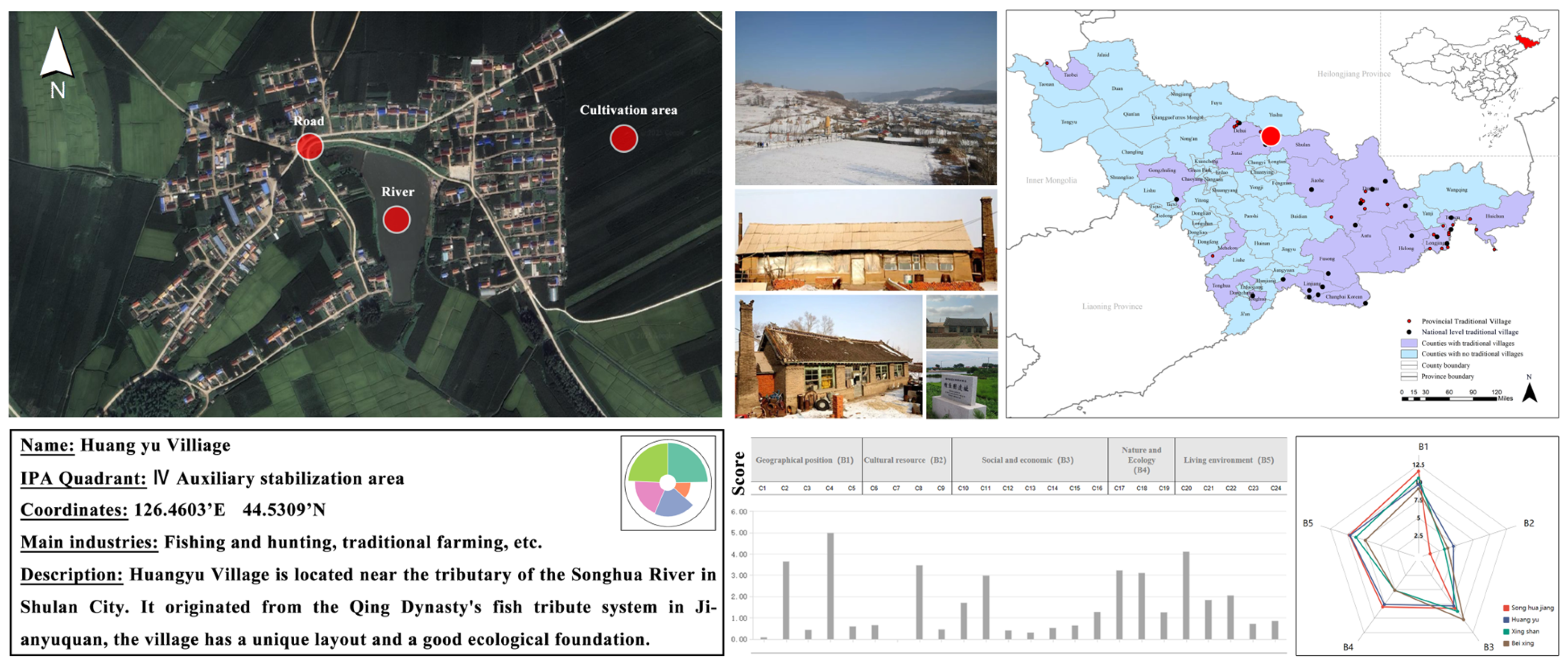
Fourth quadrant: Huangyu Village
Huangyu Village belongs to the “good foundation–insufficient awareness” type of village, with a low score in the cultural resources dimension (B2), reflecting that its Dazheng Wulagong fish culture has not yet formed a clear development path or public awareness system (Figure 18). In contrast, its scores in the dimensions of geographical position, ecological environment, and living environment are relatively balanced, indicating that its overall spatial environment is good and has strong practical expressiveness, but its cultural value has not been fully recognized and transformed, limiting its development potential score.
In general, the score structure of villages in various quadrants exhibits substantial variations in five dimensions. Villages in the first quadrant are motivated by culture and economy, while those in the second quadrant are unable to leverage their resource advantages in a meaningful way. The potential value of villages in the fourth quadrant must be promptly stimulated through cultural re-recognition and resource integration, while those in the third quadrant have weak resources and potential. This differential analysis clearly indicates traditional villages’ classification, guidance, protection, and revitalization.

4. Discussion

4.1. Analysis of the Adaptability and Innovation of Research Methods

For the purpose of achieving a systematic assessment and classification of village resource bases and potential levels, we developed a five-dimensional traditional village Development Potential Assessment system and implemented the AHP-entropy value method, coefficient of variation method, kernel density analysis, and the IPA model. The rationality of weight setting was enhanced by the integration of expert judgment and data objectivity through AHP and entropy; the coefficient of variation quantifies the dispersion of indicators, revealing the dominant factors of potential differences, and kernel density analysis identifies high-potential area trends.
The IPA model classified traditional villages into four development categories through the “resource performance–potential score” space, overcoming traditional single-level classification constraints. This facilitates intuitive identification of resource–potential disparities, providing a precise zoning foundation for revitalization strategies. Overall, this system is adaptable and valuable, integrating data foundation with application orientation.
Regarding the applicability of this methodology, the combination of AHP-entropy, IPA analysis, and coefficient of variation is suitable for regions with diverse village characteristics, like Heilongjiang, Liaoning, and Inner Mongolia, due to its flexibility in handling geographical, cultural, socio-economic, and environmental data. The methodology’s integration of expert knowledge with objective data allows it to address regional challenges related to governance, financing, and demographics. Therefore, this methodology can be applied to traditional villages in regions facing similar issues, providing valuable insights for revitalization efforts.

4.2. Spatial Unevenness and Structural Differences in the Development Potential of Villages

The development potential of traditional villages in Jilin Province is characterized by a unique spatial disparity, with a relatively concentrated distribution in the southeastern region and a relatively sparse distribution in the western and northern regions. The potential for localized spatial agglomeration phenomena is relatively concentrated in the densely distributed villages of the eastern peripheral areas.
On the other hand, the western and central plain regions have a lower number of villages, and the development potential is dispersed sporadically. There are no clear primary areas of potential. Traditional villages in the eastern mountainous regions, which possess a rich cultural heritage and a robust natural ecology, serve as superior foundations for development from the standpoint of the relationship between spatial structure and resource endowment. These regions are primarily situated in the transition zone between mountains and hills, which offers substantial advantages in terms of cultural and ecological resources. Despite the relatively convenient transportation and flat terrain of certain villages in the central and western regions, their development momentum is relatively feeble due to a lack of cultural resources, increased population mobility, and insufficient policy attention.
The coefficient of variation analysis results further substantiate the structural disparities in the development potential of villages (Figure 19). In particular, the spatial disparities are more pronounced in the two dimensions of cultural resources (B2) and social and economic (B3), which are critical variables in the expansion of the potential of villages. This also indicates that there are not only spatial disparities in resource endowments between villages, but also substantial differences in the development foundation and potential-release capacity. These differences necessitate the integration of location-based policies and geographical patterns.

4.3. The Dilemma of Village Development Under the Mismatch Between Resources and Potential

The IPA analysis indicates that certain traditional villages in Jilin Province exhibit substantial resource–potential mismatches. Despite the presence of strong resource foundations, the potential for development has not been fully realized. In contrast, some villages show strong current performance but lack intrinsic momentum for sustained development. Villages classified in the second and fourth quadrants are the most notable examples of this structural deviation. Huorongou Village, located in the second quadrant, has a relatively complete immigrant culture system and valuable mountainous ecological resources. It scores high in cultural resources but faces weak potential in terms of social and economic conditions and living environment. This reflects the dilemma of “rich resources but weak conversion,” where challenges, such as industrial hollowing out, severe population outflow, and insufficient infrastructure, prevent the transformation of these resources into sustainable development. These villages face barriers to activating their resource advantages, primarily due to insufficient financing and a lack of industrial guidance, which hinders long-term revitalization efforts.
The issue of “good foundations but insufficient cultural awareness” is exemplified by villages in the fourth quadrant, such as Huangyu Village. These villages have strong geographical advantages, natural ecology, and living environments. However, the transition from “strong performance” to “strong potential” is hindered by deficiencies in the exploration and dissemination of cultural resources. This issue is exacerbated by a lack of effective governance and limited policy support. Moreover, villages such as Rongxing Village in the third quadrant demonstrate a “low resource and low potential” state. These villages remain marginalized and unable to self-regulate or integrate into the regional development system, reflecting broader issues in governance and policy engagement. These factors—weak local governance, inadequate policy frameworks, and limited investment opportunities—prevent these villages from accessing the resources needed for sustainable development.
These findings align with those of other studies on rural revitalization in Northeastern China. Research in Liaoning and Heilongjiang provinces has highlighted similar challenges, particularly with governance issues and financing constraints. For instance, studies have pointed out that villages with strong resource bases but weak governance structures struggle to capitalize on available opportunities for industrial development and cultural preservation. Similarly, demographic challenges, such as aging populations and outmigration, are frequently cited as key barriers to revitalization. These common challenges emphasize the need for more integrated governance and targeted policy interventions to address the regional disparities in rural development across Northeastern China.
The discrepancies observed in Jilin Province suggest that the development of traditional villages is not solely determined by resource endowments but is deeply influenced by governance, financing, and demographic factors. Even villages with exceptional resources are unable to generate sustainable development without strong industrial guidance, planning support, and a healthy socio-economic environment. These findings underscore the importance of addressing these factors in future revitalization strategies to fully realize the development potential of traditional villages.

4.4. Recommendations for Activation Utilization Strategies Based on IPA Types

According to the findings of the IPA analysis, traditional villages in Jilin Province can be classified into four distinct development categories, each corresponding to distinct resource structures and potential characteristics. This study suggests targeted revitalization and utilization strategies (Table 6) to achieve the development objectives of “classification and implementation of measures, and precise improvement” by concentrating on the differences in cultural exploration, spatial governance, and industrial development among different types of villages.
(a)
The first quadrant (core-driven area) is characterized by villages that possess evident development potential, outstanding cultural value, and robust resource bases. They should be prioritized in the list of key protection and revitalization demonstration villages, thereby fostering a “branding + diversification” development path. In addition to bolstering the display of cultural heritage and increasing the capacity of tourism, they should ensure that industrial integration and community participation are guided to develop model projects that have regionally driving effects.
(b)
The second quadrant (potential activation area) village has robust cultural and ecological resources, but it lacks effective spatial organization and industrial support, resulting in a state of “dormant resources.” The efficiency of converting resources into development momentum can be enhanced by utilizing infrastructure construction and public service enhancement as a guide to promote resource identification, value transformation, and appropriate development.
(c)
The villages in the third quadrant (basic upgrading area) should prioritize functional improvements and basic maintenance. Ecological restoration and village renovation are suggested as a foundation for the gradual enhancement of the living environment and social ecology through village micro-upgrades, environmental management, and fundamental cultural sorting. This will establish the groundwork for future development.
(d)
Villages in the fourth quadrant (auxiliary stabilization area) exhibit “good performance but weak recognition” due to their relatively favorable conditions and inadequate cultural exploration. It is advisable to fortify the identification and reconstruction of cultural resources, improve local identity and brand communication, and, concurrently, utilize community participation and cultural revival as the foundation for the expansion of the supporting infrastructure for industrial and cultural development.
Table 6. Strategies for revitalizing and utilizing different types of traditional villages.
QuadrantAreaRevitalization Strategy
ICore-driven area1. Branding and diversified development, strengthening the display of cultural heritage
2. Enhancing tourism carrying capacity, promoting industry and community integration
IIPotential activation area1. Infrastructure construction and improvement of public services
2. Improving resource conversion efficiency and appropriate development
IIIBasic upgrading area1. Ecological restoration and village remediation
2. Basic cultural sorting and environmental governance
IVAuxiliary stabilization area1. Strengthening the identification and reconstruction of cultural resources
2. Enhancing brand recognition and local cultural revival

4.5. Limitations of the Study and Future Prospects

This study has systematically identified the categories of development potential of traditional villages in Jilin Province through the construction of a multi-dimensional DPA system and the introduction of the IPA model. However, there are still certain limitations. On the one hand, the accuracy and explanatory power of the assessment are impacted by the limited data acquisition and the difficulty of comprehensively covering soft factors, such as the micro-space of villages, the activity of intangible culture, and the subjective perceptions of villagers. In contrast, the assessment system is a static model that must still account for the dynamic process of changes in village resources and potential over time to reflect their evolutionary tendencies and sensitivity to policy responses.
Additionally, while AHP provides a structured way to incorporate expert judgment, it inherently introduces subjectivity, as the opinions of the experts may vary. Future studies could reduce this subjectivity by increasing the diversity of the expert panel and conducting sensitivity analyses to evaluate the impact of varying expert opinions on the results. The entropy method, while objective, is sensitive to extreme values or outliers in the dataset, which can affect the assigned weights. To address this limitation, future research could implement outlier detection and normalization techniques to ensure more reliable and robust results.
The spatial expressiveness and human-centered dimensions of the indicator system should be improved through future research. Additionally, a dynamic assessment mechanism should be implemented to enhance the model’s predictive capabilities and timeliness, and comparative studies should be conducted on a larger scale to provide more widely applicable technical support for the revitalization of traditional villages and classified protection.

5. Conclusions

The research objects of this study are 47 traditional Chinese villages in Jilin Province. A Development Potential Assessment system is constructed based on five dimensions: geographical position, cultural resources, social and economic conditions, nature and ecology, and living environment. It proposes differentiated revitalization and utilization strategies and comprehensively employs the AHP-entropy value method, coefficient of variation method, kernel density analysis, and the IPA model to systematically assess the development potential of villages from the perspectives of quantitative evaluation, spatial distribution, and structural types. The primary conclusions are as follows:
(1)
Traditional villages in Jilin Province have a relatively low overall development potential. In this evaluation, none of the sample villages achieved high or higher potential levels, with the aggregate level being medium or lower. This implies that traditional villages are still suffering from substantial deficiencies in the areas of spatial revitalization, industry introduction, and cultural resource transformation, and their potential has not yet been completely realized. The process of integrating traditional culture and rural space requires further investigation.
(2)
The spatial pattern of development potential is characterized by concentration in the southeast and dispersion in the northwest. Villages in the eastern region, which is represented by Dunhua City, are densely distributed and have relatively good resource foundations and concentrated potential. In contrast, villages in the central and western regions are fewer in number, scattered in distribution, and lack sufficient development momentum, demonstrating significant regional disparities.
(3)
The coefficient of variation and kernel density analysis reveal the spatial dispersion and agglomeration characteristics of the development potential of villages. This suggests that there are significant resource imbalances and development gaps between villages, which must be addressed through strengthened coordination and guidance based on zoning identification.
(4)
The IPA model efficiently partitions the types of resource–potential relationships, and the four-quadrant results indicate mismatches such as “development lagging but resource-rich” and “good performance but cultural weakening.” Diverse resource structures and development path requirements are demonstrated by various types of villages, including Jiapi Gou, Huorong Gou, Rongxing, and Huangyu Village.
(5)
This paper suggests three types of revitalization strategies, organized according to the IPA classification: first, the enhancement of the primary guidance of villages in terms of brand building and display; second, the activation of village resources by supplementing their deficiencies and transforming and upgrading them; and third, the cultivation of the foundations of villages primarily through restoration, remediation, and cultural re-identification, with an emphasis on “classification and implementation of measures, and policy-making based on the characteristics of each village.”
This study not only establishes an empirical foundation for the revitalization and utilization of traditional villages in Jilin Province but also offers a theoretical reference for the development of a scientific and promotable framework for evaluating the development potential of traditional villages. In the future, it is recommended that we incorporate a wider range of data, including dynamic monitoring and the perspectives of villagers, to enhance the adaptability and precision of the assessment model. Dynamic monitoring systems, such as the use of remote sensing and real-time data collection, can track the ongoing changes in village resources and development. Additionally, incorporating villagers’ voices through qualitative research methods like interviews and focus groups would provide deeper insights into the challenges and needs of local communities, ensuring that revitalization strategies are aligned with the aspirations of the villagers themselves. This will enhance the preservation and revitalization of rural cultural heritage.
The findings of this study offer significant guidance for provincial-level policy beyond Jilin Province. Policymakers can use these insights to design region-specific revitalization strategies that address the unique challenges of traditional villages, particularly in the areas of governance, financing, and cultural preservation. Future provincial policies should focus on targeted investments in infrastructure, cultural resource management, and community development, ensuring that revitalization strategies are tailored to the distinctive characteristics of each region. Additionally, policy frameworks should support local governance capacity building, facilitate financial access, and incorporate community-driven decision-making to promote sustainable rural revitalization.

Author Contributions

Conceptualization, G.Z. and C.W.; methodology, software, validation, formal analysis, C.W.; investigation, data curation, C.W. and Y.Z.; writing—original draft preparation, C.W.; writing—review and editing, G.Z. and C.W.; visualization, C.W. All authors have read and agreed to the published version of the manuscript.

Funding

This research was funded by Research on the Protection and Utilization Model of Traditional Villages in Jilin Province Based on the Integration of Culture and Tourism, grant number 2023-R-08. The APC was funded by Jilin Jianzhu University.

Data Availability Statement

Data is contained within the article.

Conflicts of Interest

The authors declare no conflicts of interest.

References

  1. Niu, X.; Tan, L.; Liu, F.; Wang, X. Spatial Zoning of China’s Marine Cultural Heritage Based on Spatial Statistical Analysis and GeoDetector. Trop. Geogr. 2024, 44, 532–546. [Google Scholar]
  2. Hua, Z.Z.; Jamaludin, O.; Ing, D.S. A review on traditional villages protection and development in China. Construction 2024, 4, 140–149. [Google Scholar] [CrossRef]
  3. Jeníček, V. Sustainable development of landscape and village—The criterion of multi-functionality. Agric. Econ. 2003, 64, 233–238. [Google Scholar] [CrossRef]
  4. Warsiki, A.Y.N.; Nusanto, G.; Kusumayudha, S.B.; Rahatmawati, I.; Herastuti, H. Mapping Village Potential in Developing Village Tourism Efforts in Karangasem District, Gunung Kidul. SHS Web Conf. 2025, 212, 4046. [Google Scholar] [CrossRef]
  5. Scott, J. Tourism for Peace?: Reflections on a Village Tourism Project in Cyprus. Anthropol. Action 2012, 19, 5–20. [Google Scholar] [CrossRef]
  6. Li, J. Community Building: An Exploration of the Path in Traditional Village Conservation and Renewal with an Example of Yim Tin Tze in Hong Kong. J. Environ. Agric. Stud. 2022, 3, 1–6. [Google Scholar] [CrossRef]
  7. Tang, C.; Yang, Y.; Liu, Y.; Xiao, X. Comprehensive evaluation of the cultural inheritance level of tourism-oriented traditional villages: The example of Beijing. Tour. Manag. Perspect. 2023, 48, 101166. [Google Scholar] [CrossRef]
  8. Zhang, S.; Li, Z.; Liu, S. Exploring the Tourism Development Potential and Distinctive Features of Traditional Wooden Architecture in Central Hunan: A Case Study of 18 Villages. Sustainability 2025, 17, 2573. [Google Scholar] [CrossRef]
  9. Qiao, B.; Wu, T.; Wang, Y. Research on the Protection and Activation of Traditional Villages in the Context of Rural Revitalization: A Case Study of Huangshan City, Anhui Province, China. J. Sociol. Ethnol. 2023, 5, 43–56. [Google Scholar] [CrossRef]
  10. Tian, M.; Ding, S. Revitalization Mechanism of Traditional Villages Based on Catalyst Theory: A Case Study of Leju Village in Yunnan Province, China. Appl. Math. Nonlinear Sci. 2024, 9. [Google Scholar] [CrossRef]
  11. Wang, L.; Zhuang, J.A.; Wang, M. Integrating AHP-SBE for Evaluating Visitor Satisfaction in Traditional Village Tourism Landscapes. Sustainability 2025, 17, 3119. [Google Scholar] [CrossRef]
  12. Zhen, C.; Chen, Z.; Liu, X.; Xie, H. The revitalization of public spaces in guangfu traditional villages based on space syntax: A case study of jiaoyuan ancient village in zhaoqing city. Trends Soc. Sci. Humanit. Res. 2024, 2, 63–71. [Google Scholar] [CrossRef]
  13. He, D.; Zhang, Y. Revitalization of Traditional Villages Oriented to SDGs: Identification of Sustainable Livelihoods and Differentiated Management Strategies. Buildings 2025, 15, 1127. [Google Scholar] [CrossRef]
  14. Kehua, W.; Weici, S.; Shi’an, Y.; Wei, L.; Yang, C.; Zhenzhen, J. Analysis on the geographical pattern and driving force of traditional villages based on GIS and Geodetector: A case study of Guizhou, China. Sci. Rep. 2023, 13, 20659. [Google Scholar]
  15. Duan, Y.; Chen, M.; Liu, Y.; Wang, Y.; Zhang, L. Research on the Cultural Landscape Features and Regional Variations of Traditional Villages and Dwellings in Multicultural Blending Areas: A Case Study of the Jiangxi-Anhui Junction Region. Appl. Sci. 2025, 15, 2185. [Google Scholar] [CrossRef]
  16. Wang, Y.; Huang, A.; Wang, F.; Cheng, Z.; Wang, M. Land Use Functions Serve as a Critical Tool for Advancing the Settlements Quality Assessment in Traditional Villages: A Case Study of Guizhou Province. Land 2025, 14, 462. [Google Scholar] [CrossRef]
  17. Zhang, Q.; Yang, C.; Cao, F. Characteristics and Causes of Cultural Landscape of Changbai Mountains Traditional Villages in Jilin Province Based on Regional Style and Features. In Proceedings of the 2019 International Conference on Architecture: Heritage, Traditions and Innovations (AHTI 2019), Moscow, Russia, 25–27 February 2019. [Google Scholar]
  18. Ministry of Housing and Urban-Rural Development of the People’s Republic of China. List of Villages Included in the Sixth Batch of China’s Traditional Village Register; Ministry of Housing and Urban-Rural Development of the People’s Republic of China: Beijing, China, 2024.
  19. China Traditional Villages Network. List of Villages Included in the Traditional Village Register; China Traditional Villages Network: Beijing, China, 2024.
  20. Jilin Provincial Bureau of Statistics. 2024 Statistical Yearbook of Jilin Province; Jilin Provincial Bureau of Statistics: Beijing, China, 2025.
  21. Wei, F.; Zhao, J.; Yang, L.; Lin, B. Evaluation on the Level of Activation Development of Traditional Villages—A Case Study of Shaanxi Provience. Chin. J. Agric. Resour. Reg. Plan 2023, 44, 162–173. [Google Scholar]
  22. Zhao, W.; Xiao, D.; Deng, Y.; Huang, Y.; Zhang, C.; Cheng, J. Research on Revitalization and Utilization Mode of Traditional Villages Based on Assessment of Development Potentials. South Archit. 2020, 3, 57–63. [Google Scholar]
  23. Yuanyi, Z.; Jiaohua, C.; Zhenjiang, S.; Shuhu, L.; Xiao, T.; Mitsuhiko, K. Study on the construction of energy-saving evaluation index system for the development of low-carbon industrial—A case study in Pingtan of Fujian Province, China. Energy Rep. 2021, 7, 86–92. [Google Scholar]
  24. Zheng, X. Research on the evaluation index system of rural revitalization potential based on classification promotion: Survey data from 6 villages in 3 counties and cities of Fujian Province. Soc. Sci. 2019, 6, 36–47. [Google Scholar]
  25. Digital Museum of Traditional Chinese Villages. Evaluation and Recognition Index System for Traditional Villages (Trial Version); Digital Museum of Traditional Chinese Villages: Beijing, China, 2024. [Google Scholar]
  26. Ying, M.; Bing, W.; Rongrong, J. Research on Performance Evalaution of Rural Revitalization Led by Rural Tourism: Take Wang Wu Cun of Taiyuan as an Example. Chin. J. Agric. Resour. Reg. Plan 2021, 42, 124–131. [Google Scholar]
  27. Xiao-Lan, T.; Zhuo-Ran, Z.; Yu, A. Landscape resource evaluation based on gis-ahp analysis in xishan traditional villages of Tai lake. J. Gansu Agric. Univ. 2017, 4, 23–30. [Google Scholar]
  28. Zhang, Z.; Liu, X.; Liu, W. Comprehensive Evaluation of the Quality Improvement of Gaoyi Ancient Village Based on AHP-Entropy Method. Furnit. Inter. Des. 2023, 30, 124–131. [Google Scholar]
  29. Tang, C.; Wan, Z.; Liu, M.; Chen, Y.; Feng, L.; Liu, Z.; Zhuo, M. Perception and improvement of the protection and inheritance of traditional village cultural heritage based on Multi-agent. J. Arid Land Resour. Environ. 2021, 35, 196–202. [Google Scholar]
  30. Huan-zhou, J.; Hai-long, S.; Xue-zhen, H.; Dong-dong, X.; Ting-feng, Y.; Xian-chun, W. Research on the Measurement of Farmers’ Livelihood Adaptability of the Key Rural Tourism Destinations in Guizhou Province—A Case Study of 4 Traditional Villages in Qiandongnan. J. Southwest Univ. Nat. Sci. Ed. 2020, 42, 83–91. [Google Scholar]
  31. Long, T.; Ișık, C.; Yan, J.; Zhong, Q. Promoting the sustainable development of traditional villages: Exploring the comprehensive assessment, spatial and temporal evolution, and internal and external impacts of traditional village human settlements in hunan province. Heliyon 2024, 10, e32439. [Google Scholar] [CrossRef]
  32. Zhang, W.; Yang, H. Quantitative Research of Traditional Village Morphology Based on Spatial Genes: A Case Study of Shaanxi Province, China. Sustainability 2024, 16, 9003. [Google Scholar] [CrossRef]
  33. Huang, Y.; Zhao, Z.B. Residents’ Perception and Spatial Structure of Landscape Change in Tourism Communities: A Case Study of Shuhe Old Town in Lijiang. J. Nat. Resour. 2018, 33, 1029–1042. [Google Scholar]
  34. Chu, Y.; Zhao, Z.; Zhang, C.; Chen, Y. Spatial features of preference difference and conflict potential among multi-groups in tourism community: A case of Tangyu town in Xi’an. Acta Geogr. Sin. 2016, 71, 1045–1058. [Google Scholar]
  35. Zhang, X.; Liu, S. Spatio-temporal differentiation and influencing factors of traditional villages in Jiangxi from a multidimensional perspective. Sci. Technol. Eng. 2024, 24, 12296–12307. [Google Scholar]
  36. Liu, X.; Shi, W.; Zhang, S. Progress of research on urban growth boundary and its implications in Chinese studies based on bibliometric analysis. Int. J. Environ. Res. Public Health 2022, 19, 16644. [Google Scholar] [CrossRef]
Figure 1. Geographic distribution of traditional villages in Jilin Province and sampling sites for the study.
Buildings 15 02475 g001
Figure 2. Research framework for assessing the development potential of traditional villages in Jilin Province.
Buildings 15 02475 g002
Figure 3. Flowchart of the combined weighting method for determining indicator weights in the Development Potential Assessment (DPA) system.
Buildings 15 02475 g003
Figure 4. IPA analysis showing four strategic areas for revitalization based on resource–potential relationships.
Buildings 15 02475 g004
Figure 5. Distribution of weights for guideline layer indicators in the Development Potential Assessment (DPA) system.
Buildings 15 02475 g005
Figure 6. Combined weight analysis of evaluation indicators in the Development Potential Assessment (DPA) system for traditional villages in Jilin Province.
Buildings 15 02475 g006
Figure 7. (a) Radar chart showing the weightings of various evaluation indicators; (b) Weighting curve chart for various evaluation indicators.
Buildings 15 02475 g007
Figure 8. Ranking of the development potential scores for traditional villages in Jilin Province.
Buildings 15 02475 g008
Figure 9. Spatial distribution of traditional villages with different development potential levels in Jilin Province.
Buildings 15 02475 g009
Figure 10. (a) Box plots of the five dimensions of village scores (* means p < 0.05; ** means p < 0.01); (b) Scatterplot of village scores on five dimensions.
Buildings 15 02475 g010
Figure 11. Kernel density analysis of the development potential of traditional villages in Jilin Province from different dimensions.
Buildings 15 02475 g011
Figure 12. Guideline-level indicator dimension indicator coefficient of variation violin chart.
Buildings 15 02475 g012
Figure 13. IPA analysis showing four strategic quadrants for revitalization based on resource–potential relationships.
Buildings 15 02475 g013
Figure 14. Distribution of traditional villages in Jilin Province according to the IPA quadrant and potential composition of representative villages.
Buildings 15 02475 g014
Figure 15. Archives of Jiapigou Village.
Buildings 15 02475 g015
Figure 16. Archives of Huoronggou Village.
Buildings 15 02475 g016
Figure 17. Archives of Rongxing Village.
Buildings 15 02475 g017
Figure 18. Archives of Huangyu Village.
Buildings 15 02475 g018
Figure 19. Coefficient of variation for each dimension and spatial structure analysis of development potential in Jilin Province’s villages.
Buildings 15 02475 g019
Table 1. Development Potential Assessment (DPA) index system for evaluating traditional villages in Jilin Province.
Target Layer AGuideline Layer BEvaluation Layer CInterpretation
Development Potential Assessment of Traditional Villages in Jilin Province (A)Geographical Position (B1)Distance from urban center (C1)The developmental interdependence and spatial location relationship between villages and town centers
Transportation accessibility (C2)The grade and quantity of transportation infrastructure, and its accessibility throughout the four seasons
Distance from nearest transportation hub (C3)The spatial distance from the village to the nearest highway, railway, station, and other transportation nodes
Economic location (C4)The level of economic development in the county where the village is located
Surrounding scenic resources (C5)The distribution and grade of tourist attractions in the surrounding areas of the village
Cultural Resource (B2)Rural honorary titles (C6)Honorary titles awarded to the village by various levels of government and organizations
Intangible cultural heritage transmission (C7)The number and activity level of intangible cultural heritage projects, and the extent to which residents continue traditional customs
Tangible cultural heritage (C8)The number of immovable and movable cultural heritage sites, the overall design, structural features, decorative details, and scale of existing traditional buildings (groups)
Historical environmental elements (ancient trees, wells, ancient bridges, etc.) (C9)Historical environmental elements listed in the National Register of Traditional Villages, current preserved historical ecological elements, and restoration/repair projects
Social and Economic (B3)Village-level governance (C10)The extent of public participation in rural governance and development
Population size (C11)Rural permanent resident population density standards
Population aging (C12)The proportion of elderly residents in the village’s permanent population
Population hollowing out (C13)The gap between the permanent resident population and the registered household population of the village
Ethnic composition (C14)Whether the village is a single-ethnicity settlement, a multi-ethnic mixed settlement, and whether it possesses cultural purity
Per capita annual income (C15)The per capita yearly income of village residents
Level of industrial development (C16)The degree of modernization and efficiency of agriculture, and the annual income of the village collective
Nature and Ecology (B4)Ecological environment status (C17)Vegetation coverage rate, terrain undulation degree, and soil fertility degree
Water environment status (C18)The association between site selection and river water bodies
Natural disaster risks (C19)Frequency and severity of natural disasters such as floods, waterlogging, typhoons, and geological hazards
Living Environment (B5)Planning and construction status (C20)Internal road network density, village core density, and per capita green space area in squares
Public service facility coverage (C21)The status of facilities such as education, elderly care, healthcare, sports, and commerce
Infrastructure completeness (C22)The status of productive and living infrastructure
Planning authenticity (C23)The extent to which the village’s location and layout restore traditional lifestyles and the comprehensive value they reflect
Consistency of built landscape (C24)The village’s texture, street scale, spatial layout, and architectural style reflect the imprint of the times
Among these indicators, C8, C16, C19, and C20 are qualitative indicators using a scoring method, with values ranging from 1 to 5 points. The remaining 20 indicators are quantitative indicators based on actual surveys of traditional villages. After quantifying the 24 indicators, they are standardized for subsequent weighting and comprehensive scoring calculations.
Table 4. Guideline layer indicator dimension indicator coefficient of variation.
Guideline Layer BAverage ( μ )Standard Deviation ( σ )Coefficient of Variation ( c v )
Geographical position (B1)7.8002.7180.349
Cultural resource (B2)9.4317.5480.800
Social and economic (B3)7.3653.4920.474
Nature and ecology (B4)6.2101.7890.288
Living environment (B5)6.4392.9220.454
Table 5. IPA Quadrant Analysis of 47 National and Provincial Traditional Villages in Jilin Province.
QuadrantAreaQuantity/ProportionCharacteristicsTypical Villages
ICore-driven area12/25.53%They perform well in terms of existing resources (such as geographical position, cultural resources, ecological environment, etc.) and development potential (such as cultural tourism, intangible cultural heritage inheritance, etc.), and have strong potential for sustainable development. They occupy a dominant position among traditional villages in Jilin Province and are suitable for further improvement in resource integration and utilization.Dapu Chaihe Village, Jindale Village, Jiapi Gou Village
IIPotential activation area7/14.89%They have a strong foundation in terms of resources, but their actual performance has not fully realized their potential, and their development is lagging behind. The reasons for their underperformance may be related to imperfect infrastructure construction and insufficient development of cultural resources.Huorong Gou Village, Xintun Village
IIIBasic upgrading area19/40.43%They are relatively weak in terms of existing resources and development potential and are lagging behind in development. Resource scarcity and inadequate infrastructure have created significant bottlenecks in their development.Langchaihe Village, Rongxing Village
IVAuxiliary stabilization area9/19.15%They are relatively weak in terms of existing resources, but have great development potential, especially in terms of cultural heritage protection, intangible cultural heritage inheritance, and tourism development, where there is significant room for improvement.Songhua Jiang Village, Huangyu Village, Xingshan Village
Disclaimer/Publisher’s Note: The statements, opinions and data contained in all publications are solely those of the individual author(s) and contributor(s) and not of MDPI and/or the editor(s). MDPI and/or the editor(s) disclaim responsibility for any injury to people or property resulting from any ideas, methods, instructions or products referred to in the content.

