1. Introduction
The application and integration of urban design methods in territorial spatial planning provide a variety of strategies that effectively promote the incorporation of urban design results into territorial spatial planning management, ensure results can be smoothly integrated into the statutory system of territorial spatial planning at the appropriate level and fully realize their functions [
1,
2]. At present, in the process of urbanization, the public is increasingly focusing on improving the quality of urban spatial environments [
3]. However, the current territorial spatial planning has not incorporated urban design into the statutory planning system, while the application of urban design methods and spatial control and governance capabilities are not prominent, so the enhancement of the urban spatial environment still faces great challenges [
4].
The policy objective of “Beautiful Land and Space” proposes the coordinated development of ecology, culture, and spatial planning, but this goal lacks sufficient theoretical support. To fill this gap, this study is grounded in sustainable urban development theory, which emphasizes the coordinated development of environmental protection and efficient resource utilization, and spatial governance theory, which focuses on the effective management of spatial resources and multi-stakeholder collaboration. The research explores how to achieve a balance between urban design and ecological conservation in complex geographical environments and provides a concrete theoretical framework and practical guidance for such regions.
In the southwestern region of China, particularly in the cities located in the “Intermontane Basins” of Yunnan Province (“Bazi” cities), urban design faces unique demands due to the distinctive geographical environment and ecological challenges. “Intermontane Basins” refer to the basin terrain between mountains, which provide relatively level terrain suitable for urban development while also being constrained by complex topography, ecological conservation requirements, and the need to preserve historical and cultural heritage. In the planning process of such cities, balancing urban development with ecological protection—particularly how to implement effective spatial governance under complex topographical conditions—has become an urgent issue. Although China’s spatial planning system has seen significant advancements in recent years and the national level has begun to emphasize the role of urban design, there remains a lack of targeted guidance and methodologies for urban design in areas with complex terrain, especially in unique geographical settings like intermontane basin “Bazi” cities. While existing research has explored the integration of urban design with spatial planning, practical guidance tailored to regions with intricate topography remains limited. Although existing studies have explored the integration of urban design and spatial planning, most have focused on urban areas with relatively simple terrain. This study addresses this critical gap by examining the specific needs of cities located in intermontane basin cities. It not only considers the integration of urban design and ecological conservation but also provides concrete methods for spatial governance in mountainous environments. The paper discusses how to effectively apply urban design under the constraints of complex terrain and highlights the current lack of such targeted approaches in research. Therefore, this study aims to explore urban design methods applicable to these areas and provide references for future spatial planning practices.
Similarly, urban design in other countries around the world also faces its own unique challenges. For instance, in the United States, urban design emphasizes community engagement and achieves spatial governance through regional planning and local regulations. In large cities (e.g., New York and Los Angeles), community planning and urban design have become an important part of land use planning [
5]. France, on the other hand, has responded to the disorderly sprawl caused by accelerated urbanization through a municipal-based urban planning system and constructed a spatial control system through regional and local planning [
6]. In the UK, since the enactment of the Town and Country Planning Act (1947), urban design has been incorporated into the statutory system and become a key tool for land use management [
7]. Germany attaches great importance to ecological protection and balances spatial development and environmental protection through green infrastructure construction. However, urban design in all countries also faces challenges when confronted with the problem of rapid urbanization, such as limited ability to manage climate change, traffic congestion, and housing shortage. In addition, excessive ecological protection may disrupt the balance of economic and social development. In Asia, Japan has incorporated urban design into its territorial spatial planning system through laws such as the Urban Redevelopment Law, with a particular focus on historical and cultural preservation and spatial renewal. For example, Kyoto controls building heights and styles through strict landscape regulations to preserve historical and cultural features [
8]. However, rapid urbanization and changes in social structure have limited the flexibility of urban design, and spatial control in Japanese cities continues to face the challenge that control methods cannot be effectively implemented. Singapore has achieved efficient spatial governance based on a highly centralized planning system. Singapore’s governance experience shows that urban design is not only a tool for shaping space, but also an important means for solving social, economic, and environmental issues [
9]. Through integrated planning, Singapore has achieved remarkable results in coordinating infrastructure development, land use, environmental protection, and economic development issues, but its high degree of centralization has also limited the diversity and resilience of urban design, making it difficult to meet the unique needs of some communities. Although urban design has been incorporated into statutory planning in many countries, deficiencies in the governance structure still affect the effectiveness of its actual control [
10,
11,
12]. For example, urban design in the United States often creates conflicts between community planning and overall urban planning, while the United Kingdom and Japan encounter challenges in coordinating local and central control [
13]. Overall, the efficiency of spatial governance and the effectiveness of urban design management in the international context have yet to meet the desired expectations.
Although global urban design strategies respond to the challenges of urban planning, they often ignore the complexity specific to intermontane basins, and these geographical environments bring additional constraints. For example, current urban designs focus on historical preservation and integrated planning, but these cities still face difficulties in applying design principles to mountainous or basinal terrains. A comparative analysis of globally representative urban design practices, such as the San Fernando Valley in Los Angeles, USA, and the city of Grenoble in France, reveals the challenges and limitations these cities face when addressing the unique conditions of intermontane basins. The San Fernando Valley, located approximately 30 km northwest of downtown Los Angeles in Southern California, spans an area of 895 square kilometers and represents an urbanized valley. Although Los Angeles’ urban design incorporates community engagement and regional planning, traditional spatial planning methods struggle to be effectively implemented in the San Fernando Valley due to its complex terrain and challenges such as wildfire risk management. Similarly, Grenoble, the capital of France’s Auvergne-Rhône-Alpes region and the Isère department, has a population of around 390,000 and is situated at the heart of the Alps at an elevation of 214 m. While Grenoble has achieved notable success in urban design within its valley area, extending these principles to surrounding mountainous regions, such as the Vercors Massif, proves difficult due to limited transportation accessibility and ecological conservation requirements. These international cases demonstrate the constraints of conventional urban design models when applied to complex mountainous terrains and underscore the necessity of adopting tailored design approaches for intermontane basin cities—an innovative solution proposed in this study.
To improve urban design efficiency and governance, China issued the Opinions of the State Council and the Central Committee on Establishing a Territorial Spatial Planning System, aiming to integrate urban design throughout spatial planning. The Ministry of Natural Resources further clarifies urban design’s role in guiding spatial governance, focusing on the protection of urban and natural landscapes. The shift from “blueprint design” to “spatial governance” highlights the importance of landscape features and natural patterns [
14]. However, challenges remain in emphasizing landscape characteristics and implementing urban design methodologies across regions. While previous studies have addressed mechanisms and institutional designs for territorial spatial planning [
15], more research is needed on the application of urban design in different geographic environments and spatial control mechanisms, especially in managing use control and spatial management [
16,
17]. In Southwestern China, intermontane basins, or “Bazi”, are key residential and transportation hubs [
18]. This study uses Mile city in Yunnan as a case study to explore urban design strategies and control challenges in these unique geographic environments, offering design recommendations for such cities.
This study makes the following innovative contributions. First, it pioneers the development of a comprehensive control indicator system specifically tailored for intermontane basin cities. Using Mile City in Yunnan Province as a case study, the research proposes a unique “city + countryside + landscape” control network, emphasizing the dynamic integration of natural and cultural landscapes with urban development, distinguishing it from traditional urban design methods. Second, this study marks the first application of China’s national spatial planning guidelines in intermontane basin cities in Yunnan, exploring how these principles can be adapted to complex terrains and regional characteristics. This approach provides novel insights for spatial governance in such regions. Additionally, the research introduces a multi-scale indicator control system, offering a more sophisticated approach to spatial development regulation compared to existing frameworks. This includes control metrics for building height restrictions, ecological conservation zones, and landscape design, among others. By addressing the challenges of spatial control in mountainous basin areas, this study establishes a valuable framework for sustainable urban-rural development. This study focuses on the unique geographical features of intermontane basin cities. By identifying the specific challenges posed by complex terrain and ecological constraints, the study provides a new perspective and methodology for urban design and spatial governance. This targeted approach not only enriches the existing urban design framework, but also provides practical guidance for cities in similar geographical environments to ensure that urban development can be coordinated with ecological protection and cultural heritage, while effectively managing spatial governance.
2. Literature Review
2.1. Integration of Urban Design and Spatial Planning in China
In China, the study of territorial spatial planning began in the late 1970s [
19]. However, due to the imperfection of the statutory system, the actual control effect of urban design is limited. The academic community calls for it to run through the whole process from master planning to detailed planning [
20] and play a role in the protection of local characteristics [
21]. In recent years, China has gradually improved the legalized system of urban design, and at the same time, combined with international experience, it has effectively promoted ecological protection and historical and cultural inheritance through regional design [
22,
23,
24].
However, this process has also yielded lessons and warnings, reminding us that spatial planning policies must remain vigilant against the dual socio-ecological risks posed by urban expansion. For instance, Chongqing, a quintessential city of urban-rural integration in China, faced challenges of excessive sprawl and planning missteps during its rapid urbanization, particularly from the 1990s to the early 2000s. During this period, while promoting large-scale urbanization, Chongqing experienced a disconnect between urban and rural areas, lagging transportation infrastructure, and ecological degradation. These issues revealed that, in the absence of effective urban design governance, urbanization tends to exacerbate urban-rural fragmentation and unsustainable resource depletion. Thus, Chongqing’s experience offers valuable insights for cities undergoing urban-rural integration, such as those in Yunnan’s multi-ethnic regions. By drawing on these lessons, future planning can strengthen the preservation of local identity, guide urban expansion more rationally and prioritize the sustainable development of ecological and historical-cultural systems.
2.2. Challenges of Urban Design in Yunnan’s Intermontane Basins
Yunnan, as a typical intermontane basin region, is unique in terms of geological conditions and geographic environment (
Figure 1). The region has gradually conducted suiting local conditions in combining urban design and territorial spatial planning [
25], and has enacted relevant laws to support the practical application of urban design [
26,
27]. Some scholars have pointed out that the integration of urban design and territorial spatial planning should be strengthened in Yunnan region, and innovative strategies should be proposed for different levels of refined management in order to cope with the multiple challenges of the intermontane basin cities [
28,
29,
30,
31]. Although existing studies have emphasized the importance of urban design in enhancing the spatial quality of cities [
32], they are not yet sufficient in theory and practice on how to achieve fine control in the geographically complex and ecologically sensitive mountainous plateau terrain area, and are less likely to carry out systematic control explorations for the spatial qualities of cities located in the intermontane basin. Therefore, how to achieve a balance between ecological protection [
33], resource utilization and spatial development in these areas through scientific urban design methods is still one of the hotspots worthy of research.
Yunnan Province in China features diverse topography, including plateaus, mountains, valleys, basins, lakes, and forests. It is rich in plant species and mineral resources, but its complex terrain presents challenges for urban development [
34]. The Yunnan Plateau, with its steep and gently sloping mountains, creates a fragile ecological environment and complicates urban planning (
Table 1). The province has 1442 “Bazi” areas, with 49 exceeding 100 square kilometers. These areas, home to 6% of the province’s population, are vital for urban development, but their growth has led to ecological degradation [
35]. The increasing conflict between ecological preservation and economic development makes land use planning and urban design particularly challenging in the region.
Yunnan’s unique topography presents multiple challenges for urban design. The complex terrain, including significant height differences and mountain canyons, limits buildable land and complicates planning. Additionally, the region’s fragile ecological environment requires careful disaster prevention [
36]. The concentration of population in these areas intensifies competition for land, making efficient land use a pressing issue. Urban design must balance economic development with environmental protection. Guided by ecological civilization and territorial spatial planning, comprehensive control of Yunnan’s “Bazi” areas—encompassing mountains, rivers, forests, fields, lakes, and cities—is essential. Current issues include disorderly urban expansion, loss of arable land, and the degradation of landscape characteristics [
37]. To ensure high-quality development, it is crucial to balance land protection and urban-rural development. Urban planning must account for topographic complexity, ecological protection, transportation needs, and cultural preservation, ensuring sustainable spatial management for the region’s distinctive landforms.
3. Methodology
3.1. Case Selection and Study Area
This section focuses on research methodology, outlining case selection criteria, data collection strategies, and analytical techniques employed in the study.
This study is a case study. The case study requires surveys and interviews with personnel engaged in urban design work in various planning departments and design institutes across Yunnan Province. This study utilized relevant data and drawings of Mile City provided by the Planning Department of Yunnan Province, combined with relevant policy texts, and collected different data through multiple methods to facilitate the acquisition of control strategies and relevant conclusions on how urban design methods are applied in intermontane basin cities in Yunnan area.
Mile City is located in Southeastern Yunnan Province and Northern Honghe Prefecture, renowned as the “Back Garden of Central Yunnan”. Located within the territory of Honghe Hani and Yi Autonomous Prefecture in Yunnan Province (103°04′–103°49′ E, 23°50′–24°39′ N), the city is renowned as the “Northern Gateway of Honghe Prefecture”. Situated 316 km north of the national-level port of Hekou, it enjoys a strategic geographical position with convenient transportation. The city boasts a well-developed transport network: the Kunming−Hekou Highway runs through its territory for 93 km, the Yunnan−Vietnam Railway spans 78 km along its western border, and the G80 Guangzhou−Kunming Expressway traverses the area. These geographical and transportation advantages have established Mile City as a vital transport hub in Southeastern Yunnan, further enhancing its academic significance as a research subject—particularly for its exemplary value in urban spatial planning and regional coordinated development. Covering an area of 4004 square kilometers, the city has a permanent population of 533,900, with ethnic minorities accounting for 39.95% of the total population. Its urbanization rate reaches 59.05%. Mile City in Yunnan Province is a typical “Bazi” city, reflecting the characteristics of a plateau intermontane city. Its development history showcases the impact of urban planning, particularly in adapting to the natural environment. Since the 20th century, Mile has become a key city in Southeastern Yunnan, shaped by planning policies and a tradition of coordinated urban management. These data resources form the empirical foundation for the case study methodology, enabling detailed spatial and policy analysis.
Mile’s urban pattern has always emphasized the coordination of terrain and ecology, distinguishing it from cities with less planning. Early development in Mile focused on land resources, infrastructure, and ecological protection. Recently, the city has gained practical experience in urban design as it promotes new urbanization.
The questions and hypotheses of this study are listed below: (1) research questions—How can urban design methods be utilized in territorial spatial planning to achieve more efficient spatial control, especially for the intermontane “Bazi” cities in Yunnan area? How can this control process be established?; (2) research hypothesis—By employing a methodology that combines text analysis, image analysis, and interview to construct an urban design index control system, a framework for urban design control in territorial spatial planning can be established. It is hypothesized in the study that urban design methods, through optimizing spatial layout, enhancing functionality, and controlling the character of the cityscape, can enhance the sustainable development capabilities of Yunnan’s intermontane-type “Bazi” cities (
Figure 2).
This study adopts an evidence-based methodology, combining program analysis, diagrammatic observation, interviews, and policy research. The research focuses on recent spatial planning practices in Mile City, analyzing implementation plans, urban design, and spatial control. Policy analysis is used to review relevant Yunnan “Bazi” city policies and planning documents, examining the indicators of the past decade’s “National Land and Space Management Measures” and the policy frameworks guiding urban design. The study also employs image analysis to visually present urban design methods, conducting multiple surveys with local stakeholders to assess attitudes on spatial planning.
Based on this, the study constructs quantifiable indicators for optimizing spatial layout, enhancing functionality, and controlling urban character, aiming to improve the sustainable development of intermontane “Bazi” cities. By integrating qualitative analysis tools, the study evaluates the relationship between policy and practice, providing both theoretical and practical guidance for the future development of these cities.
3.2. Content Analysis of Planning Documents
In the territorial spatial planning of urban-rural integration areas, planners must analyze, classify and refine traditional urban and rural spatial elements to establish a planning philosophy that balances protection and development and implement practical planning and construction measures [
38,
39,
40,
41,
42]. Mile City, an urban-rural integration area, follows an “urban landscape in basin + urban spatial development” pattern. To gain an in-depth understanding of the regional planning context, we conducted a comprehensive review of key documents, including “the Mile City Territorial Spatial Master Plan (2021–2035)”and urban-rural development planning reports provided by Yunnan Urban-Rural Planning and Design Co., Ltd., with particular attention to the urban design scheme for Xishan Town area (pp. 13–20). Additionally, we referenced historical archives and cultural scrolls obtained from the Keyi Cultural Tourism Village administration, which provided valuable insights into the region’s historical-cultural heritage and ecological environment.
Development plans by Yunnan Urban and Rural Planning and Design Co., Ltd. focus on the landscape protection area, integrating intermontane-basin characteristics. The Xishan Town urban design plan showcases architectural and spatial organization that adapts to the site, reflecting the cultural and historical values of the basin environment without altering natural features like farmland, water systems, and forests. The cluster layout avoids linear designs, preserving a traditional basin urban landscape in harmony with nature. Public services are distributed according to this spatial form.
In identifying urban design methodologies, the research team first analyzed current land-use maps through qualitative methods, determining that Keyi Village’s built-up area covers approximately 15.3 hectares, with surrounding gentle slopes and partial mountainous areas designated as agricultural land interspersed with natural hills. Elevation analysis revealed a topographical depression pattern, with higher peripheral terrain and lower central elevation. The built environment primarily occupies gentle slopes, forming a characteristic cascading, semi-enclosed settlement layout.
Through detailed examination of the conservation zoning map, the research team extracted and analyzed critical spatial data, which clearly delineated the boundaries of three functional zones: the core protected area, the construction control area, and the environmental coordination area. The map further specified building height restrictions and visual corridor controls, identifying key vantage points, important view passages, and landscape visual control sectors. These systematically organized spatial parameters provided essential evidence-based support for both the preservation of Keyi Ancient Village and its subsequent urban design interventions.
Ecological planning documents distinctly outlined three functional zones: village construction areas, forest conservation areas, and agricultural protection districts. Transportation system schematics detailed primary roads, secondary roads, pedestrian tourist paths, main village access points, and parking facilities. This integrated graphic-textual approach enabled comprehensive identification of Keyi Village’s urban design elements, forming a robust database for subsequent design proposals and management recommendations. Through systematic cartographic and textual analysis, the urban design control framework was found to prioritize the following key elements:
- (1)
Overall contour protection and control: Mile City’s spatial planning clearly defines protection areas, using compact cluster layouts to conserve land resources and maintain harmony with the natural landscape. This layout optimizes urban functional areas and ensures visual continuity, particularly between the mountains and basin areas [
43,
44].
- (2)
Natural landform space contour control: The design fully considers the basin’s geomorphology, protecting the natural landscape and minimizing environmental damage. By controlling visual corridors and limiting building heights, the transition between urban form, mountains, farmland, and water systems is preserved, maintaining the overall landscape’s harmony [
45].
- (3)
Ecological and economic co-design: Ecologically sensitive areas are demarcated to protect forests, farmlands, and other environments, preventing encroachment. The integration of forest resources with agriculture and tourism fosters local industries, such as grape and pomegranate cultivation and hot spring tourism, which protect ecology while promoting economic growth. Urban development is based on ecological capacity, emphasizing conservation to prevent unchecked expansion. The design balances traditional architecture with natural landscapes, creating a spatial layout that is both historically rich and modern, maintaining landscape sustainability [
46,
47].
- (4)
Traffic and transportation node design: Planning departments manage space limitations due to natural conditions and develop urban designs that integrate mountains and transportation, ensuring functional connectivity and supporting the basin-pattern city structure [
48,
49].
Transportation planning focuses on adapting to natural landforms, minimizing ecological impacts, and optimizing accessibility. The network should follow natural features like mountains and rivers, avoiding large-scale terrain disruption and protecting sensitive areas. Circular roads and a hierarchical traffic system ensure efficiency and environmental protection in areas with significant elevation changes. Traffic nodes are strategically placed between functional zones to improve accessibility. A multi-level network, including main, secondary, and side roads, enhances connectivity within the city and between urban and rural areas, supporting integrated development (
Figure 3,
Figure 4,
Figure 5 and
Figure 6).
Mile City’s urban design focuses on three key aspects:
(1) Integration of forest environment with tourism and agriculture: the city’s forest, agricultural, and tourism resources (grapes, pomegranates, and hot springs) drive economic growth while preserving ecology, creating a sustainable development model. (2) Protection of history and natural environment: the city emphasizes preserving historical towns and traditional villages, balancing conservation with development. (3) Natural condition constraints and layout control: the compact layout adapts to the basin terrain, restricting building heights and harmonizing with nature, ensuring sustainable land use and fostering integrated urban-rural development.
3.3. Visual Analysis of Planning Maps
According to the Draft for Public Review of “Yunnan Provincial Urban-Rural Development Plan” jointly compiled by the Yunnan Provincial Department of Housing and Urban-Rural Development and Yunnan Design Institute Group, the province’s urban-rural development emphasizes harmony with nature due to its characteristic mountainous and basin-interlaced topography. This has resulted in diverse and rich spatial forms of urban settlements. Constrained by complex terrain and farmland preservation requirements, traditional towns typically exhibit concentric, layered spatial patterns and a “three-along” land use distribution (along mountains, water bodies, and roads). The comprehensive physical geographic environment significantly influences spatial development, with basin cities throughout the province, demonstrating distinct spatial characteristics of lakeside, river valley, and mountainous interlocking patterns.
For visual analysis, this study employed visual assessment methods to examine the spatial planning evolution diagrams of intermontane basin cities from the aforementioned plan. By integrating historical satellite imagery and field survey data, we conducted detailed visual examinations. This image analysis enabled us to identify the interlaced distribution of mountains, lakes, and river valleys, along with their profound impacts on urban spatial morphology, thereby providing data support for subsequent spatial optimization and design adjustments. Based on these analyses, we further deduced the evolutionary process of basin-city design, which can be summarized into two distinct phases (
Figure 7).
3.3.1. Basic Stage of Decentralized Layout and Ecological Protection
At this stage, the planning department positioned the urban layout at the edge of the basin area or the decentralized development between villages, and the connection between urban and rural areas was relatively weak. By delimiting the protection boundary, ecological baseline, and river control line of the basin area, the planning department has initially realized the basic protection of land and ecology in the basin area. However, the overall functional area was still relatively scattered, and efficient spatial organization had not yet been formed.
3.3.2. Integration, Development, and Function Optimization Promotion Stage
The planning department focuses on integrating ecological protection, cultural heritage, and functional optimization. The design uses a compact, group-based layout that merges urban functions with ecological conservation in the basin. By optimizing traffic nodes and integrating functional areas, urban-rural connectivity is improved. Ecological protection is reinforced with clear ecological corridors, green spaces, and water systems, creating a spatial pattern of mountains, basins, water, and cities. Urban functions are diversified, blending agriculture, tourism, residential, and commercial elements. The protection and development of historical towns emphasize regional and cultural values.
Through visual analysis, we identified multiple key elements and conducted in-depth examinations of spatial configurations, ecological-urban design integration, transportation networks, and topographic characteristics. The graphical representations distinctly annotate geographic features including mountain ranges, lakes, villages, urban areas, and transportation routes, revealing their dynamic interactions with surrounding natural environments (e.g., mountainous terrain and river systems). Notably, at the convergence zones of lakes, mountains, and transportation networks, the diagrams explicitly demarcate critical natural elements such as ecological corridors, protected areas, and shoreline buffers, demonstrating balanced approaches between urban development and ecological conservation. Regarding transportation infrastructure, the illustrations display hierarchically classified transit corridors and their spatial impacts on urban-rural configurations, particularly highlighting the interface between external transport arteries and ecological corridors. This provides valuable insights into coordinating transportation systems with environmental protection requirements. Contour lines and mountain range markings visually articulate topographic variations, illustrating how the spatial arrangement of highlands and waterways fundamentally influences urban design decisions and expansion zone selection. Furthermore, the annotated “Urban Growth Boundary Controls” and “Sustainable Ecological Space Regulations” within the graphics (
Figure 7) offer clear visual guidance for implementing spatial governance strategies in complex natural environments, with the cartographic representations.
Figure 7 illustrates the evolution of spatial planning in intermontane basin cities, highlighting the transition from decentralized to integrated, ecological, and functionally optimized layouts, with significant improvements in ecological protection, transportation, and urban-rural connectivity. In the plateau basin area, urban design generally follows these approaches: ① strengthening segmented guidance and control, focusing on protecting the natural mountain profile and creating a dense, undulating urban contour; ② connecting ecological spaces and landscape nodes, emphasizing the creation of slow lanes, public activity spaces, and leisure facilities to form dynamic, open public spaces; ③ implementing flexible design in ecological fringe areas, enhancing architectural and landscape control.
This study demonstrates the effectiveness of these methods through image analysis. The compact group layout optimizes space utilization and coordinates functional zoning, transportation systems, ecological continuity, and cultural preservation. Using Mile City as an example, the planning department has successfully created a model of ecological conservation, functional optimization, and cultural inheritance, providing valuable insights for spatial planning in plateau intermontane basin cities.
Mile City’s urban and rural planning highlights the importance of natural environmental factors in intermontane basin cities. Larger cities benefit from a multi-center cluster layout, while smaller cities suit a centralized, compact development. The layout should be adapted to local conditions, with a focus on banded or multi-center clusters. The primary goal is to preserve the basin area’s ecological security and protect high-quality cultivated land. Planning should prioritize ecological boundaries, mountain, cultivated land, and traffic as core elements, defining growth boundaries based on terrain. Urban-rural integration is achieved through ecological corridors and traffic routes, while industry should align with these corridors to ensure smooth internal and external connectivity. Development should adapt to the terrain, guiding settlements into suitable mountain areas for a balance of ecological protection and urban growth.
3.4. Interview-Based Indicator Development
3.4.1. Interview Survey
In territorial space planning, urban design should focus on the natural ecological characteristics of urban and rural areas, balancing spatial expansion land and natural land to ensure sustainable land use and ecological balance [
50]. Based on the characteristics of urban and rural spaces in most Yunnan basin areas and the spatial form control requirements of “key control areas” in the “Territorial Space Urban Design Guide”, control zoning and principles are outlined. Through interviews and research, the team engaged with local planning departments, design units, policymakers, and residents in Mile City to establish control rules and indicators for urban design, gathering multi-level information. The results reveal that Mile City’s urban design focuses on three principles: “ecological priority, cultural inheritance, and functional optimization”, leading to a series of operational control rules and indicators.
This study treats urban design as both a technical and participatory process and thus employed interview-based techniques to capture governance perspectives. Within territorial governance processes, the engagement of local governments, design institutions, and residents proves indispensable. By establishing appropriate spatial design control indicators, stakeholders can be empowered to play meaningful roles in decision-making, enabling substantive contributions to ecological conservation, historic-cultural preservation, and social equity.
In alignment with international sustainable urban governance standards, this study adopts ISO37120 “Sustainable Cities and Communities—Indicators for City Services and Quality of Life” as its evaluative framework [
51]. This internationally recognized standard incorporates 17 thematic dimensions (including economy, health, governance, transportation, and urban planning) with 100 standardized indicators (46 core indicators), particularly emphasizing spatial justice, equitable access to public services, ecosystem service protection, and inclusive governance. For constructing Mile City’s spatial governance system, the research integrates four ISO 37120 dimensions—“spatial structure”, “environmental management”, “public service accessibility”, and “governance participation”—to conduct preliminary impact assessments across different social groups. A tailored interview module was developed, engaging residents, planners, and local policymakers to articulate responses regarding ecological protection, cultural revitalization, and service equity. Through qualitative analysis of these multi-stakeholder perspectives, the study ensures the inclusivity and practical feasibility of urban design proposals, thereby effectively addressing diverse spatial demands.
In order to further refine the development requirements and control indicators of urban spatial aggregation in intermontane-type basin cities, the research team designed a series of thematic interviews. There were 120 interviewees including planners of local planning departments, designers of design institutions, experts and scholars, and urban and rural residents, with a total of 120 people. Specifically, the participant composition was as follows: urban planners from local planning departments accounted for 7.5% (9 individuals), designers from planning institutions represented 56.7% (68 individuals), academic experts comprised 2.5% (3 individuals), and urban or rural residents constituted 33.3% (40 individuals). The interview content was the specific application of urban design in management and control mechanism, implementation effect, and practical feedback. It aimed to clarify the core difficulties and improvement direction of current urban design, and verify the scientificity and feasibility of design indicators (
Table 2).
The study employed semi-structured interviews with participants spanning diverse professional backgrounds and local residents, organized around five core thematic domains: basin spatial pattern regulation, spatial configuration control, landscape character management, urban form order governance, and public space and amenity.
Interview data underwent qualitative analysis to extract key operational indicators—including ecological priority zone area, building height restrictions, ecological corridor coverage ratios, land use efficiency, and public service facility distribution—ensuring the practical applicability of regulatory measures.
To facilitate open expression while maintaining focus, we implemented participatory interview methodologies. The design incorporated multiple engagement mechanisms to capture cross-stakeholder perspectives effectively. For instance, community feedback loops enabled residents to articulate needs regarding ecological conservation and infrastructure development while granting tangible participation in decision-making processes.
In designing the interview framework, we meticulously formulated questions specifically aligned with urban design governance priorities, ensuring comprehensive coverage of diverse participant perspectives across planning, design, and implementation phases. Each question was strategically anchored to distinct regulatory domains to facilitate the collection of multidimensional feedback from varied stakeholders:
- (1)
Basin spatial pattern regulation: Questions such as “Are functional zoning boundaries for construction land clearly defined?” and “How effective are ecological restoration control measures?” were primarily directed to planning authorities, design institutions, and academic experts. These aimed to assess the rationality of land use allocation and efficacy of ecological protection mechanisms. Such inquiries helped clarify specific planning requirements for land utilization while ensuring enforceable implementation of conservation protocols.
- (2)
Spatial configuration governance: Questions like “Do axial corridors and central systems adequately reflect regional identity while fulfilling functional needs?” focused on gathering professional evaluations from planners and designers regarding design appropriateness. The supplementary question “Do road networks, rail transit, and greenway systems optimize transportation efficiency?” provided technical feedback from transport management agencies and design professionals on network optimization.
- (3)
Landscape character management: Structured questions including “Do building materials and architectural styles authentically represent basin characteristics?” and “Do building height and color schemes comply with landscape conservation standards?” targeted both design practitioners and residents. This dual-perspective approach ensured cultural authenticity and natural landscape compatibility while operationalizing aesthetic preservation.
- (4)
Urban form order control: technical assessments such as “Are building height and floor-area ratio controls appropriately calibrated?” and “Do landmark placements achieve skyline harmony?” enabled cross-validation between planning departments and design firms regarding architectural-urban visual coherence.
- (5)
Public space and amenity provision: community-oriented questions (“Do public spaces and green infrastructure meet residents’ daily needs?”) combined with planning audits (“Are amenities and lighting systems equitably distributed?”) ensured evidence-based service provision aligned with socioeconomic equity principles.
The strategic selection of these questions ensured comprehensive articulation of multi-stakeholder perspectives across all critical dimensions of urban design. This inclusive approach yielded holistic feedback essential for formulating actionable regulatory guidelines with operational precision.
During the interviews, data were systematically recorded through audio documentation and written transcripts, enabling the research team to identify five core regulatory indicators. Regarding basin spatial pattern regulation, 56% of respondents prioritized three key metrics: ecological protection zone coverage (requiring ≥60% of the area), building height restrictions (capped at 1/3 of local terrain elevation in core zones), and ecological corridor connectivity (maintaining ≥85% coverage). Spatial configuration governance garnered support from 67% of participants, emphasizing a minimum land use efficiency target of 80%. For landscape character management, 66% advocated for strict alignment of building materials, architectural styles, and color schemes with basin regional identity. Notably, 70% stressed urban-rural form integration, insisting on coordinated controls for building heights and floor-area ratios, while 72% of experts emphasized skyline-adapted height limitations. Concerning public space provision, 80% of residents demanded improved lighting and infrastructure, underscoring the need for community-centric amenity distribution.
3.4.2. Extraction of Control Indicators
The opinions and data from interviews provide a foundation for the detailed management and control of urban design in Mile City, verifying the applicability of quantitative indicators. This interview-based method offers insights for spatial planning and control systems in similar cities. The planning department should refine the control elements and methods, implementing binding indicators.
Certainly, beyond physical and visual criteria, urban design governance indicators should also incorporate strategies for optimizing spatial configurations, enhancing accessibility to public service facilities, and mitigating spatial inequities to achieve regional balance and fairness. This approach not only fosters social justice but also reinforces ecological sustainability, ensuring that natural resources and ecosystem services are equitably distributed to all residents—particularly in geographically complex environments such as intermontane basins.
The study further references the international standard ISO 37120 “Sustainable Development of Communities—Indicators for City Services and Quality of Life”. Formulated by ISO37120 Technical Committee on Sustainable Cities and Communities, this standard was officially launched on 15 May 2014 during the Global Cities Summit in Toronto, Canada [
51]. It establishes a comprehensive evaluation framework comprising 100 indicators (including 46 core and 54 supporting indicators) across 17 domains encompassing economy, environment, health, governance, transportation, and urban planning. The indicator system emphasizes critical dimensions such as spatial justice, equitable accessibility of public services, ecosystem service preservation, resilience, and inclusive governance, thereby providing a unified framework for assessing urban sustainable development.
In developing the urban design control regulations and quantitative indicators for Mile City, this study draws upon the core evaluation methodologies from ISO 37120’s indicator system, specifically focusing on “spatial structure”, “landscape character”, “morphological order”, “spatial systems”, “safety resilience”, and “environmental management”. These international standards were systematically adapted to China’s unique intermontane basin topography and current urban-rural integration context, resulting in a tailored spatial governance system for highland basin cities. Through iterative consultations with local planning authorities, policymakers, and community residents, the research team synthesized a comprehensive set of urban design guidelines that simultaneously address local practicalities while maintaining alignment with global frameworks.
Consequently, the research team has systematically developed an integrated set of design control regulations and indicator systems specifically tailored for intermontane basin cities, encompassing five critical dimensions (
Table 3):
① Basin pattern control: it includes construction land (area, land use, and restoration), basin area space (spatial form, green space, and land use), traffic corridors (width, range, and type), and ventilation corridors (range, type, and level); ② overall spatial pattern control: it covers axis belt system (position, function, and characteristics), central system (position, development, function, and characteristics), spatial groups (range, type, and function), and traffic skeleton (structure, transit lines, greenways, and density); ③ basin style and features: they focuses on style partitions (materials, color, and design), basin area style (height, color, and design), building color (range), and multi-dimensional perception (roof type, greening, and lighting); ④ spatial form order: it includes height intensity (building height and development), landmark system (position, height, type, and style), skyline (range, contour, and height), and overlooking system (view location and control); ⑤ space system: it covers mountain green space (level, area, and service radius), public space (area, square facilities, and plant configuration), mountain corridor network (street type, building line, and section control), and supporting systems (hierarchy, service radius, facilities, and lighting).
Scientific urban design needs to run through the whole process of land and space planning and construction, and plays the role of overall guidance, coordination, and management [
52]. However, most urban designs pay more attention to formalization and fail to play the control role of urban design. Under the system of land and space planning, it is necessary to establish a management and control framework for refined urban design, so as to achieve the effect of reasonable connection of various parts in actual construction, so that urban planning and construction can be smoothly promoted. The perfect management assessment and feedback mechanism in the process not only helps to implement the control role of urban design, but also helps to master the urban planning and construction in practice.
3.4.3. Establishment of the Management and Control Method Evaluation System
This study extracted the control indicators through interviews and surveys, combined with the requirements of the “Land Space Urban Design Guidelines” based on the spatial development of intermontane basin cities in Yunnan, studied and judged local characteristic resources and coordinated the overall spatial relationship. The research refines the key content of urban design in the “three types” planning level and summarizes three morphological control elements (
Table 4): (1) space as a whole: it covers the scale of construction land, the form of urban landscape, and the spatial elements of basin area and landscape space; (2) spatial pattern: it includes the functional layout of the basin area, spatial form, traffic space, public center system, landscape space system, basin area spatial boundary, field protection space, and sight space; (3) spatial features: it involves urban skyline, building contour line, basin area building interface, building interface, basin area corridor, landscape system, and facility shelter. The study combines urban design methods with the spatial resources of intermontane basin cities and systematically summarizes these elements, providing an important basis for planning and control.
In the previous section,
Table 3 outlines the specific requirements of urban design in terms of spatial regulation, covering regulatory rules and related indicators in areas such as the intermontane basin model, spatial framework, and landscape features. It clarifies the control objectives and key elements in each domain, such as the scale of construction land and architectural style. Building upon the requirements of
Table 3,
Table 4 further refines the implementation rules and evaluation criteria for each regulatory domain. It emphasizes how to apply regulations according to different planning phases and control levels (e.g., master planning, detailed planning, and strategic guidance), providing a concrete operational framework and execution methods to help achieve the goals proposed in
Table 3.
In summary, through textual analysis, the research team identified key elements influencing the urban design of Mile City, including spatial layout, architectural design, ecological conservation, and historical-cultural preservation. The textual analysis helped clarify the priority areas requiring focused control in urban design. Secondly, image analysis validated the practical effectiveness of the design methods, particularly in aspects such as building height control and visual corridor protection. This analysis further clarified how to achieve rational layout and landscape control based on topographic features and ecological needs, offering practical guidance for refining regulatory steps. Thirdly, interview surveys provided valuable feedback for improving the regulatory details. By engaging with local planning departments, design agencies, policymakers, and urban and rural residents, the research team collected extensive feedback on the implementation of urban design, uncovering practical issues and directions for improvement.
By integrating textual analysis, image analysis, and interview data, the study can further summarize the spatial design regulatory rules applicable to intermontane basin cities, establishing a framework of such rules and ensuring their effective implementation in urban planning and construction through a scientific step-by-step process.
4. Results
4.1. Strategic Framework for Spatial Design in Mile City
Based on the case study, interviews, and image analysis of Mile City, this research summarizes spatial design control regulations for intermontane basin cities and outlines a step-by-step process for spatial planning and design in similar cities. These steps integrate ecological protection, functional optimization, style shaping, and dynamic management to ensure effective implementation of planning goals. The urban design methods and quantitative indicators used in Mile City reflect a multi-dimensional approach to environmental protection, cultural heritage, and spatial optimization. The local planning department emphasized combining the mountain forest ecology with agricultural tourism, aiming for an ecological corridor coverage rate of over 85%. To protect historical and natural environments, a coordinated cultural landscape design is recommended to preserve historical towns and promote the harmonious development of culture and landscape. The architectural layout should prioritize adaptability to natural conditions, optimize land use through cluster layouts and strictly control building heights in core areas. The compact layout covers 90%, with over 60% of land dedicated to ecological protection, ensuring the integration of landscape and urban space (
Table 2). The compact layout covers 90%, with over 60% of land dedicated to ecological protection, ensuring the integration of landscape and urban space. The design control steps are shown in
Figure 8.
4.2. Three-Step Spatial Control Strategy
Step 1: Define urban boundaries to improve land use efficiency. In spatial planning, delineating urban boundaries is crucial for compact development and protecting high-quality farmland in basin areas. The goal is to guide orderly urban growth while avoiding disorderly expansion. It is necessary to assess current land use and maximize the efficiency of existing land during the urban design phase, addressing idle land to achieve effective utilization.
Step 2: Integrate regional natural landscape elements. Urban construction should respect natural landscapes, ensuring sustainability. The layout of construction land must align with spatial characteristics and ecological sustainability, integrating with the natural environment [
53]. Control over development styles in the basin area should maintain regional characteristics, optimizing the layout, protecting ecosystems, and enhancing historical context and public spaces.
Step 3: Control the development trend and overall appearance. Spatial planning for basin cities should balance natural, artificial ecological, and construction elements. The design must emphasize the unique mountain−water environment and village patterns. Planners should establish positive interactions between nature and urban development, protecting natural elements (mountains, water, forests, etc.) while controlling the landscape style. The design should cater to the specific plateau-basin features of each region (
Figure 8).
The formulation of these three strategic steps is based on a comprehensive analysis of Mile City, integrating data from land use status, image analysis, expert interviews, and other sources. Through an in-depth study of the city’s spatial layout and natural environment, we identified the necessity of rationally delineating urban boundaries, promoting multi-element development in close coordination with the natural environment, and controlling the overall landscape development of the intermontane basin area. After a detailed analysis of Mile City’s existing planning documents, historical satellite imagery, and field survey data, we proposed these three strategies to ensure balanced urban development in terms of ecological conservation, functional optimization, and historical-cultural preservation. Moreover, they provide scientifically grounded guidance for spatial planning in similar cities. These steps integrate ecological protection, functional optimization, style shaping, and dynamic management to ensure effective implementation of planning goals.
4.3. Implementation and Evaluation of Control Measures
This study presents the spatial design regulations for intermontane basin cities through the case of Mile City and outlines their implementation framework. Using case analysis, interviews, and image-based methods, the research collected data on ecologically sensitive areas, cultural preservation zones, and functional districts to develop an analytical foundation. This framework includes ecological baselines, conservation zones, zoning maps, and transportation networks. Based on this, core protected areas and development boundaries were delineated, defining restrictions for ecological and construction lands. Transportation and ventilation corridors were also incorporated into the spatial layout.
An optimized cluster layout strategy was adopted to improve land use efficiency and spatial coordination, supported by an axial and central spatial system. Functional districts were categorized with corresponding spatial roles. For character preservation, architectural design parameters were formulated, including materials, colors, height control, skyline, and view corridors. A multi-layered transportation network was planned, comprising expressways, slow-traffic paths, and green corridors, to improve public service coverage.
To support implementation, a feedback mechanism was established using real-time monitoring indicators and stakeholder inputs. The proposed regulatory measures were applied in different areas of Mile City, delineating spatial development intensity, protected zones, and public transit systems. These results provide a structured basis for spatial control in intermontane basin environments.
5. Discussion
The advantage of urban space in Yunnan’s intermontane basin cities lies in their unique mountain and water resources, providing a foundation for optimizing spatial patterns in urban design. The challenge, however, is coordinating the relationships between urban style, urban-rural symbiosis, and ecological protection. Therefore, urban construction should expand urban design control to include a regional landscape management system covering “city + countryside + scenic areas”, clearly defining the functions and boundaries of these three spaces. Urban design should integrate natural beauty, artificial beauty, and cultural heritage to create a spatial control network across the entire region (
Figure 9). This proposal is supported by findings from Mile City, where the research team has tracked planning documents, policy implementation, and stakeholder feedback, providing reliable and practical insights into regionally adaptive urban design approaches.
The control plans for city, countryside, and scenery are as follows.
5.1. Urban Area: Targeted Landscape Control in Cities
Urban areas in intermontane basin cities often contain sensitive landscape interfaces between ecological resources and built environments. Based on the findings from Mile City, this study highlights the importance of precise control over key character areas to ensure the preservation of regional identity and ecological integrity. Historical conservation zones and designated landscape buffers are integrated with transportation corridors, forming a multi-layered spatial framework that supports both accessibility and cultural continuity. Ecological control strategies—such as defining biological corridors, regulating water circulation systems, and establishing construction boundaries—demonstrate how spatial policy tools can limit ecological degradation while guiding urban form.
The integration of traditional cultural elements within slow-traffic systems reflects an attempt to humanize mobility infrastructure and reinforce place-based identity. Indicators such as land-use proportions, greening rates, and building height limits serve as measurable tools for enforcing design controls and monitoring their impact. Together, these approaches reveal a regionalized methodology that balances urban functionality with environmental and cultural preservation.
5.2. Rural Area: Urban-Rural Coordination
The results suggest that effective spatial coordination between urban and rural areas requires addressing the structural mismatches in rural-urban fringe zones. The spatial configuration of Yunnan’s basins—characterized by mountain ridges, water bodies, road networks, and scenic corridors—appears to support the development of ecological corridors and functional connections that foster urban-rural symbiosis. The design of Mile City demonstrates how aligning landscape features with urban functions can lead to integrated ecological protection and functional efficiency.
Furthermore, the observed optimization of land use in transitional areas between city and countryside reflects a strategy that enhances land value by leveraging both ecological assets and industrial functions. This integrated approach to planning contributes to the efficient use of space and supports the vitality of the broader region. The combination of transportation infrastructure, functional districts, and landscape nodes in Mile’s spatial planning serves as a model for constructing cohesive rural-urban systems. These findings underline the importance of context-sensitive design guidelines that respond to ecological conditions, industrial structure, and mobility needs, thereby promoting balanced and sustainable development across urban and rural environments.
5.3. Landscape System: Ecological and Cultural Integration
The study, based on Yunnan’s unique natural conditions, proposes strategies for constructing a composite landscape system to enhance the city’s ecological and aesthetic value. It identifies core landscape themes based on regional features, integrates cultural and ecological elements in landscape nodes and enhances city attractiveness. By utilizing the basin’s geographical conditions, the study suggests linear landscape designs that combine natural and artificial landscapes, optimizing spatial quality at a lower cost. In terms of function and form optimization, the study develops a multi-scale coordination pattern through planar and three-dimensional designs of ecological functional spaces, enhancing spatial diversity and hierarchy. The proposed city skeleton integrates linear landscapes with natural elements like mountains, water, forests, and fields. By linking ecological corridors and landscape networks, it ensures coordinated development and improves both ecological and aesthetic value. This research provides theoretical and practical guidance for spatial planning in intermontane basin cities, laying the foundation for the balanced development of ecology, function, and character.
This paper proposes an integrated “urban-rural-landscape” theoretical framework with the following significance: The framework originates from a comprehensive consideration of ecological, cultural, and functional factors in intermontane basin cities. By integrating three spatial elements—urban, rural, and landscape, it provides a holistic and coordinated perspective for spatial governance in urban design, particularly in complex terrain environments, ensuring a win-win scenario for both ecological conservation and urban development. This study, based on Yunnan’s unique natural conditions, proposes strategies for constructing a composite landscape system to enhance the city’s ecological and aesthetic value, combining ecological preservation with the optimization of socioeconomic functions, thereby advancing sustainable urban-rural integration. This framework not only facilitates ecological protection but also preserves regional cultural heritage, promotes the conservation and development of local characteristics and expands the theoretical scope of urban design.
Despite its strong theoretical and practical value, applying this framework to other regions and contexts requires consideration of the following factors:
Geographical and ecological variations: Differences in terrain, ecosystems, and climate conditions across regions directly influence the implementation of the urban-rural-landscape framework. For instance, high-altitude mountainous areas may face harsher climatic conditions and greater ecological fragility, necessitating stricter conservation measures in design. Additionally, variations in water resource distribution, vegetation types, and soil conditions must be carefully incorporated into spatial governance strategies.
Cultural and historical contexts: Each city or region possesses unique cultural and historical backgrounds, requiring tailored adjustments when applying this framework elsewhere. For example, in cities rich in cultural heritage (e.g., ancient towns or areas with numerous historical sites), the “landscape conservation” component should be reinforced, with detailed measures to protect traditional aesthetics and historical legacies.
Socioeconomic development levels: Disparities in regional economic development also affect the framework’s applicability. In less economically developed areas, urban-rural integration may face financial and technical constraints, necessitating flexible adaptations to ensure ecological and socioeconomic coordination even under limited resources.
Policy and implementation capacity: When applying this framework across different regions, the policy enforcement capacity of local governments, financial support, and technical capabilities emerge as critical factors. In certain areas, stronger governmental guidance and support may be required—particularly through financial assistance and technical expertise—to facilitate the implementation of these spatial governance measures. By thoroughly considering these factors, future research can further refine the integrated “urban-rural-landscape” framework to enhance its adaptability across diverse geographical, cultural, and socioeconomic contexts, ensuring its operational feasibility and effectiveness in broader regional applications.
In summary, the spatial design of intermontane basin cities in Yunnan needs to adopt a holistic system perspective of “city-rural area-landscape”, establishing a control network that covers the entire region to achieve the integration of natural beauty, artificial beauty, and civilizational beauty across multiple elements. Precise control of key character areas, symbiotic optimization of urban-rural junctions, and the superimposed design of regional landscape systems provide feasible paths to enhance the ecological value, spatial quality, and cultural charm of intermontane-type basin cities. This system offers practical references for the sustainable development of cities with Yunnan characteristics. Although this study proposed a relatively systematic framework and detailed rules for the design and control of space in intermontane-type cities in Yunnan, there are still some shortcomings that need further improvement. For instance, in the selection of case studies, although Mile City as a research subject has a certain typicality, the topographical conditions and development patterns of intermontane-type basin cities in Yunnan are very diverse. The guiding significance for other geographical environments and city types still needs further verification. The control indicators and methods proposed in this study may also be limited by policy implementation, financial support, and local technical capabilities in practical applications. The operability and execution difficulty of indicators in complex urban-rural junction scenarios need further refinement. Additionally, although the application of intelligent technologies (such as GIS, big data analysis, and urban digital twins) is reflected in some analyses, their role in dynamic control and real-time assessment has not been fully explored, which may lead to insufficient adaptability and flexibility of planning schemes. These shortcomings provide a clear direction for future in-depth research. The research team will also further focus on the impact of geological conditions on planning and adapt to the special characteristics of the geological environment through innovative planning schemes [
54].
The regulatory indicators and methodologies developed in this study have demonstrated effective implementation in Mile City. However, when applied to other cities with similar geographical conditions—such as other intermontane basin cities in Yunnan Province or comparable urban areas in Sichuan and Guizhou Provinces, localized adjustments must be made according to each area’s distinct geographical, ecological, and cultural characteristics. Topographical variations, for instance, may significantly influence the design of landscape corridors, transportation network layouts, and the configuration of ecological buffer zones. Higher-altitude locations require additional consideration of more complex climatic and terrain conditions. The unique cultural and historical heritage of different cities necessitates tailored approaches to balancing traditional preservation with modern functional requirements. Furthermore, variations in ecological carrying capacity across regions demand customized delineation of protected areas and development zones, with particularly fragile ecosystems potentially requiring more stringent conservation measures. Differences in policy frameworks and implementation capacity also affect outcomes, as less developed areas may require greater governmental support and technical investment for successful execution. While Mile City’s regulatory approach provides valuable reference points, these findings underscore the importance of context-specific adaptation when transferring methodologies to other intermontane urban environments. Future research should focus on optimizing these indicators and developing more flexible application frameworks that account for regional variations while maintaining core principles of sustainable spatial governance. The study highlights both the transferable value of its findings and the critical need for adaptive implementation strategies across diverse geographical and cultural contexts.
6. Conclusions
This study used a combination of text analysis, image analysis, and in-person interviews to construct an indicator control system for urban spatial design in Yunnan’s intermontane basin city, and proposed a set of systematic spatial control methods (
Table 3 and
Table 4).
This study employs an integrated methodology combining “text analysis + image analysis + field interviews” to establish an indicator-based control system for spatial design in Yunnan’s intermontane basin cities, while proposing a systematic approach to spatial regulation. The research highlights that for transitional zones between mountainous areas and basin regions, formulating zoning-based and tiered development intensity standards is crucial—not only for preserving ecosystem integrity but also for reducing development challenges posed by complex terrain. Regarding culturally sensitive areas, the study recommends integrating intangible cultural heritage preservation with modern functional needs to develop spatial development strategies that blend tradition and modernity, thereby enhancing regional cultural identity and appeal.
This study makes significant contributions to urban design, spatial planning, and regional studies. In urban design, it develops an innovative indicator-based control system tailored to intermontane basin cities, proposing balanced approaches to ecological conservation, functional optimization, and cultural continuity that enhance sustainability and socio-economic benefits. The research advances spatial planning by establishing an integrated “urban-rural-landscape” governance framework that broadens planning perspectives, emphasizing coordinated development between built environments and natural landscapes. This offers new methodologies for spatial management in complex terrains. For regional studies, the work provides adapted zoning intensity standards specifically designed for intermontane basins’ unique geographical conditions. These standards offer both theoretical foundations and practical solutions for addressing regional development challenges while maintaining ecological integrity, pushing forward academic progress in spatial planning for such distinctive landscapes.
The primary contribution of this study lies in providing a scientifically grounded and actionable urban design framework for intermontane basin cities, particularly in balancing ecological conservation, functional optimization, and cultural continuity. The proposed indicator system encompasses key elements such as building height restrictions, green space ratios, transportation corridor density, landscape zoning, and visual corridor protection. By leveraging multi-source data analysis, the study ensures the practical applicability of the theoretical framework, offering both theoretical support and practical guidance for spatial planning in similar regions.
The study’s innovations are reflected in three aspects: First, it constructs an indicator-based control system tailored to intermontane basin cities, holistically considering ecological, functional, cultural, and visual factors to ensure that urban design meets both ecological conservation requirements and socio-economic sustainability. Second, it proposes a comprehensive “urban + rural + landscape” regulatory framework, expanding the scope of urban design from traditional urban cores to peri-urban transitional zones and natural landscapes, emphasizing coordinated development between urban-rural integration and natural scenery. Third, the study specifically addresses transitional zones between mountainous and basin areas, introducing zoning-based development intensity standards that not only protect ecosystem integrity but also mitigate development challenges arising from topographical complexity.
The mixed-method approach adopted in this study offers significant advantages by integrating text analysis, visual analysis, and local interviews to examine spatial planning from multiple dimensions. However, since the methodology primarily focuses on physical, functional, and morphological variables, it has yet to fully incorporate social dimensions such as spatial justice and inclusive governance. Future research could expand these methods by incorporating theoretical frameworks from sociology, political science, and related disciplines to more comprehensively assess the social impacts and governance efficacy of urban design. Additionally, while the proposed urban design regulatory approach demonstrates strong adaptability to current planning practices, it lacks a post-implementation evaluation mechanism to measure the resilience of these interventions in addressing future challenges such as economic shifts, population growth, and climate change. To address this gap, future studies should establish a systematic evaluation framework involving periodic monitoring, data analysis, and expert feedback to assess the long-term effectiveness and adaptive capacity of these interventions, ensuring their sustainability amid dynamic socio-environmental conditions.
In future research, we will further validate the applicability of the “urban-rural-landscape” framework in other cities with similar topographic conditions. For instance, in intermontane basin cities across Guizhou and Sichuan Provinces, we will explore balanced approaches to ecological conservation and functional optimization by adapting spatial governance methods to local conditions. The study also proposes focusing on spatial development constraints and resource optimization strategies in high-altitude canyon areas, particularly examining how refined spatial design can achieve dual objectives of environmental protection and economic development in ecologically fragile regions with complex terrain. Additionally, future studies should emphasize the application of smart technologies. By employing remote sensing, real-time data monitoring and big data analytics, more scientific and efficient dynamic management tools can be developed for urban design to enhance the operational feasibility of planning and provide broader theoretical and practical support for building “Beautiful Landscapes” in Southwest China.
While the urban design control methods proposed in this study demonstrate strong adaptability, they have not fully incorporated advanced technological approaches. Future research could enhance spatial data collection and analysis by integrating remote sensing, drone surveys, and other emerging technologies to improve data accuracy and timeliness. Quantitative methods like statistical modeling and simulation algorithms could further refine the indicator system for better adaptability and operability. The study also suggests exploring applications of GIS, digital twins, and big data analytics in urban design and spatial planning, particularly for dynamic management and real-time decision-making. These technologies could provide precise spatial data support, enabling more intelligent and efficient spatial governance and plan implementation. The integration of such technical solutions would significantly upgrade current methodologies while maintaining the framework’s core principles.
In summary, the urban design regulatory approach proposed in this study provides a practical pathway for spatial planning. Future research should focus on spatial justice, equitable access to services, and inclusive governance to ensure that all social groups share in the benefits of urban development. Additionally, establishing an effective post-implementation evaluation mechanism to monitor and adjust the resilience of interventions will further enhance the sustainability and adaptability of urban design, enabling it to better address future social and environmental challenges.
This study’s exploration of spatial governance strategies for intermontane basin cities in Yunnan has broader significance beyond the regional context. The integrated “urban-rural-landscape” regulatory framework and indicator-based control system proposed here offer a transferable model that aligns with global sustainable development goals (SDGs), particularly SDG 11 (Sustainable Cities and Communities) and SDG 15 (Life on Land). By emphasizing ecological protection, cultural preservation, and spatial equity in complex terrains, this framework can inform international policy dialogues on sustainable urbanization, especially in regions facing similar topographical and socio-ecological constraints.
Moreover, the study provides a theoretical and practical foundation for the localization of international policy frameworks such as the New Urban Agenda and the Convention on Biological Diversity’s Urban Nature Agenda. Its regulatory strategies can serve as references for global institutions and national governments seeking to balance development and conservation in mountainous regions. By promoting context-specific and data-driven planning approaches, this research contributes to shaping international best practices for adaptive, inclusive, and ecologically responsible spatial governance.
Author Contributions
Conceptualization, H.C., Y.Y. and D.Z.; Methodology, H.C. and Y.Y.; Software, H.C. and W.Z.; Validation, H.C., Y.Y. and D.Z.; Analysis, H.C. and D.Z.; Investigation, H.C., Y.Y., L.Z., S.Z., R.Y. and Y.Y.; Resources, H.C., Y.Y. and D.Z.; Data curation, H.C. and L.Z.; Writing—original draft, H.C.; Writing—review & editing, H.C., D.Z., L.Z., S.Z., W.Z. and R.Y.; Visualization, H.C., W.Z. and Y.Y.; Supervision, Y.Y. and D.Z.; Project administration, H.C. and Y.Y.; Funding acquisition, H.C. and Y.Y.; Writing interviews, image analysis, and text organization, H.C. and Y.Y. All authors have read and agreed to the published version of the manuscript.
Funding
This research was funded by National natural science foundation of China grant 52478058; Yunnan Provincial Department of Natural Resources Fund Project: “Research on the Application of Urban Design in Territorial Spatial Planning and Management” grant 4530000HT202209083; The 2025 Yunnan Provincial Philosophy and Social Science Planning Annual Project “Research and Documentation of Yunnan Tea-Horse Road Architectural Heritage from the Perspective of Oral History” grant QN202522.
Data Availability Statement
The data presented in this study are available on request from the corresponding author. The data are not publicly available due to this survey design part of the privacy of the population. The original contributions presented in the study are included in the article, further inquiries can be directed to the corresponding authors.
Conflicts of Interest
The authors declare no conflict of interest.
References
- Omole, F.O.; Olajiga, O.K.; Olatunde, T.M. Sustainable urban design: A review of eco-friendly building practices and community impact. Eng. Sci. Technol. J. 2024, 5, 1020–1030. [Google Scholar] [CrossRef]
- Jiang, F.; Ma, J.; Webster, C.J.; Chiaradia, A.; Zhou, Y.; Zhao, Z.; Zhang, X. Generative urban design: A systematic review on problem formulation, design generation, and decision-making. Prog. Plan. 2024, 180, 100795. [Google Scholar] [CrossRef]
- Liu, L.; Huang, S.; Zhou, H. An exploration on the comprehensive urban design methods at the city level under the territorial planning: A case study of Nanchang. City Plan. Rev. 2023, 47, 97–105. [Google Scholar]
- Cheng, C.; Niu, S.; Pan, Y.; Hua, X. Research on urban design management and control system for efficient and global spatial governance. Planners 2023, 39, 102–109, (Translated into English). [Google Scholar]
- Linovski, O.; Loukaitou-Sideris, A. Evolution of urban design plans in the United States and Canada: What do the plans tell us about urban design practice? J. Plan. Educ. Res. 2013, 33, 66–82. [Google Scholar] [CrossRef]
- Janssen, C.; Basta, C. Are good intentions enough? Evaluating social sustainability in urban development projects through the capability approach. Eur. Plan. Stud. 2024, 32, 368–389. [Google Scholar] [CrossRef]
- Davy, B. The German Verkehrswert (market value) of land: Statutory land valuation, spatial planning, and land policy. Land Use Policy 2024, 136, 106975. [Google Scholar] [CrossRef]
- Alberti, M. Cities of the Anthropocene: Urban sustainability in an eco-evolutionary perspective. Philos. Trans. R. Soc. B 2024, 379, 20220264. [Google Scholar] [CrossRef]
- Santos, M. Urban design and consumer well-being: The role of public spaces in enhancing quality of life. J. Retail. Consum. Serv. 2024, 76, 103571. [Google Scholar]
- Orleans, P. Differential cognition of urban residents: Effects of social scale on mapping. In Image and Environment: Cognitive Mapping and Spatial Behavior; Routledge: London, UK, 1973; pp. 115–130. [Google Scholar]
- Richardson, R. Conceptualising ‘street-level’ urban design governance in Scotland. Urban Stud. 2024, 61, 1230–1247. [Google Scholar] [CrossRef]
- Kunzmann, K.R. Urban design: Some footnotes from a German perspective. J. Urban Des. 2020, 25, 25–28. [Google Scholar] [CrossRef]
- Vergara-Perucich, F.; Boano, C. Exploring the contradiction in the ethos of urban practitioners under neoliberalism: A case study of housing production in Chile. J. Plan. Educ. Res. 2024, 44, 484–498. [Google Scholar] [CrossRef]
- Wang, Y.; Yu, S. Integrated Design Scheme of Coastal Urban Planning Based on Gis Method. Inf. Technol. Newsweekly 2020, 103, 328–332. [Google Scholar] [CrossRef]
- Reimer, M. Planning Cultures in Transition: Sustainability Management and Institutional Change in Spatial Planning. Sustainability 2013, 5, 4653–4673. [Google Scholar] [CrossRef]
- Zhu, J. Public space and its publicness in people-oriented urban regeneration: A case study of Shanghai. J. Urban Aff. 2023, 1–20. [Google Scholar] [CrossRef]
- Berger, E.S.C.; Blanka, C. Comprehensive and multifaceted perspectives on sustainability, urban studies, and entrepreneurship. Small Bus. Econ. 2023, 62, 471–501. [Google Scholar] [CrossRef]
- Chen, H.; Yang, Y.; Zhao, D.; Zhang, L.; Tang, Z.; Tian, J.; Shen, T.; Yin, Y. Social Cluster and Heritage Memory: A Study on the Space Perception of Zhaozhou Basin Horse Caravan Vernacular Architecture. Buildings 2024, 14, 2405. [Google Scholar] [CrossRef]
- Xing, J.; Wang, S.; Guan, J. Look from Ningbo Laowaitan Block of Renovation and City Design of Modern History Block in Ningbo. Adv. Mater. Res. 2012, 1616, 1171–1174. [Google Scholar] [CrossRef]
- Xiong, X.; Wang, Y.; Cho, M.; Pesoa-Marcilla, M.; Sabaté-Bel, J. Space-consciousness layered model as a regeneration approach for rural industrial heritage integrating local planning: A case study on Shecun village in Nanjing, China. J. Asian Archit. Build. Eng. 2024, 23, 1063–1078. [Google Scholar] [CrossRef]
- Lingling, D.; Weifeng, Q.; Ting, F.; Li, Y. Research on Village Type Identification and Development Strategy Under the Background of Rural Revitalization: A Case of Gaochun District in Nanjing, China. Int. J. Environ. Res. Public Health 2022, 19, 6854. [Google Scholar]
- Zhang, L.; Huang, C.; Zhao, D.; Du, H.; Lu, Q.; Yu, H.; Yu, Y.; Chen, Y.; Zhang, M. Design Optimization for Urban Landscape from the Perspective of Ecological Chain, Anti-Planning and Barrier Free Design: The Unity of Natural and Social Environmental Benefits. Fresenius Environ. Bull. 2020, 29, 9095–9102. [Google Scholar]
- Omer, I.; Goldblatt, R. Spatial patterns of retail activity and street network structure in new and traditional Israeli cities. Urban Geogr. 2016, 37, 629–649. [Google Scholar] [CrossRef]
- Zhao, D.; Zhang, W.; Xie, W.; Liu, C.; Yang, Y.; Chen, Y.; Ren, C.; Chen, H.; Zhang, Q.; Folinas, S. Ecological Restoration and Transformation of Maoming Oil Shale Mining Area: Experience and Inspirations. Land 2023, 12, 318. [Google Scholar] [CrossRef]
- Peng, L. Analysis on the Ecosystem Services and Its Constraining Factors in Yunnan’s Basin-Mountain Complex Ecosystems; Yunnan University: Kunming, China, 2022. [Google Scholar]
- Wang, Y.; Sun, H.; Mo, Q.; Zhuo, C. Application of Hydrus-2D Model in Subsurface Drainage of Saline Soil in Coastal Forest Land—A Case Example of Fengxian, Shanghai. Sustainability 2024, 16, 4590. [Google Scholar] [CrossRef]
- Amati, M.; Stevens, Q.; Rueda, S. Taking play seriously in urban design: The evolution of Barcelona’s Superblocks. Space Cult. 2024, 27, 156–171. [Google Scholar] [CrossRef]
- Rick, B.; McGrath, D.; Armstrong, W.; McCoy, S.W. Dam type and lake location characterize ice-marginal lake area change in Alaska and NW Canada between 1984 and 2019. Cryosphere 2022, 16, 297–314. [Google Scholar] [CrossRef]
- Yang, J.; De, W.; Zhang, X.; Pan, Y. Research on ‘Showing Mountains’ Planning Strategy Based on Mountain Landscape Protection in Urban Central District. IOP Conf. Ser. Earth Environ. Sci. 2019, 281, 012027. [Google Scholar] [CrossRef]
- Wu, R.; Yang, Y.; He, J.; Zhu, J. A core framework of “mountain management–water management–moist city” for sponge city special planning: The case of northwestern China. Front. Public Health 2022, 10, 994137. [Google Scholar] [CrossRef]
- Joss, S. Eco-city governance: A case study of Treasure Island and Sonoma Mountain Village. J. Environ. Policy Plan. 2011, 13, 331–348. [Google Scholar] [CrossRef]
- Shao, J.; Wei, C.; Xie, D. Mountain land use planning of metropolitan suburbs: The case of the Jinyun mountain and its surrounding area, Chongqing, China. J. Mt. Sci. 2005, 2, 116–128. [Google Scholar] [CrossRef]
- Ran, Y.; Lei, D.; Li, J.; Gao, L.; Mo, J.; Liu, X. Identification of crucial areas of territorial ecological restoration based on ecological security pattern: A case study of the central Yunnan urban agglomeration, China. Ecol. Indic. 2022, 143, 109318. [Google Scholar] [CrossRef]
- Wang, Y. Innovation and Optimization of Urban Development Boundary Control Work under Territorial Space Planning. Urban Constr. Theory Res. Electron. Ed. 2024, 30, 19–21. [Google Scholar] [CrossRef]
- Ma, Y.; Yin, Q. Research on the Optimization of the Rural Construction Planning Permit Management System with Coordinated Compilation and Management—A Case Study of Yunnan Province. In China Urban Planning Society, Hefei Municipal People’s Government. Beautiful China, Co-Building, Co-Governance, and Sharing—2024 China Urban Planning Annual Conference Proceedings (12 Urban-Rural Governance and Policy Research); Kunming Urban Planning and Design Institute Co., Ltd.: Kunming, China, 2024; pp. 1100–1106. [Google Scholar] [CrossRef]
- The General Office of the Ministry of Natural Resources. Notice of the General Office of the Ministry of Natural Resources on the Issuance of the Guidelines for the Compilation of the Municipal Overall Territorial Space Planning (Trial). Nat. Resour. Commun. 2020, 19, 20–40. [Google Scholar]
- Yang, K.; Luo, Y.; Chen, K.; Yang, Y.; Shang, C.; Yu, Z.; Xu, J.; Zhao, Y. Spatial-temporal Variations In Urbanization In Kunming and Their Impact On Urban Lake Water Quality. Land Degrad. Dev. 2020, 31, 1392–1407. [Google Scholar] [CrossRef]
- Li, W.; Yang, Z. Landscape design of urban culture transmission based on the regional information security of Internet of Things. Heliyon 2024, 10, e35042. [Google Scholar] [CrossRef]
- Zhang, J. Ecological Landscape Design Strategies in Sustainable Rural Planning. Acad. J. Humanit. Soc. Sci. 2024, 7, 191–196. [Google Scholar]
- Wang, X.; Song, Y.; Tang, P. Generative urban design using shape grammar and block morphological analysis. Front. Archit. Res. 2020, 9, 914–924. [Google Scholar] [CrossRef]
- Fu, H.; Liu, J.; Dong, X.; Chen, Z.; He, M. Evaluating the Sustainable Development Goals within Spatial Planning for Decision-Making: A Major Function-Oriented Zone Planning Strategy in China. Land 2024, 13, 390. [Google Scholar] [CrossRef]
- Kalliomäki, H.; Oinas, P.; Salo, T. Innovation districts as strategic urban projects: The emergence of strategic spatial planning for urban innovation. Eur. Plan. Stud. 2024, 32, 78–96. [Google Scholar] [CrossRef]
- Zhang, W.; Yuan, Q.; Cai, H. Unravelling regional development through the production-living-ecological perspective: Assessing heterogeneity and expert insights. Urban Clim. 2024, 55, 101937. [Google Scholar] [CrossRef]
- Lu, D. Regional Development and Its Spatial Structure; Springer: Berlin/Heidelberg, Germany, 2024. [Google Scholar]
- Berisha, E.; Cotella, G.; Janin Rivolin, U.; Solly, A. Spatial governance and planning systems vis-à-vis land consumption in Europe. Eur. Plan. Stud. 2024, 32, 553–568. [Google Scholar] [CrossRef]
- White, B. The Literature and Study of Urban and Regional Planning; Taylor & Francis: Abingdon, UK, 2024. [Google Scholar]
- Berisha, E.; Cotella, G.; Janin Rivolin, U.; Solly, A. Spatial governance and planning systems in the public control of spatial development: A European typology. Eur. Plan. Stud. 2020, 29, 181–200. [Google Scholar] [CrossRef]
- Lai, S.; Zoppi, C. Sustainable Spatial Planning Based on Ecosystem Services, Green Infrastructure and Nature-Based Solutions. Sustainability 2024, 16, 2591. [Google Scholar] [CrossRef]
- Sandu-Dumitriu, M. Spatial Planning at the Fringes: Land Fragmentation and Sprawling in Bragadiru. In Uneven Real Estate Development in Romania at the Intersection of Deindustrialization and Financialization; Routledge: London, UK, 2024; pp. 138–158. [Google Scholar]
- Hatzav, Y.; Noam, R.; Shaked, F.; Plaut, P.; Grobman, Y.J. Sustainable urban landscapes: A computation framework for enhancing sustainability in early-stage design. Archnet-IJAR Int. J. Archit. Res. 2024, 18, 870–894. [Google Scholar]
- ISO 37120; Sustainable Cities and Communities—Indicators for City Services and Quality of Life. International Organization for Standardization: Toronto, QC, Canada, 2014.
- Zhang, X.; Ning, J. Land use change in coastal zones of China from 1985 to 2020. Front. Mar. Sci. 2024, 11, 1323032. [Google Scholar] [CrossRef]
- Mendes, R.; Fidélis, T.; Roebling, P.; Telesa, F.; Farrellye, M. What is spatial planning saying? A conceptual and methodological framework to assess the institutionalization of nature using critical discourse analysis. Crit. Discourse Stud. 2024, 21, 274–292. [Google Scholar] [CrossRef]
- Zhang, W.; Zhao, D.; Liu, D. Evaluation on water yield service in Nansihu River Basin of China during the recent 20 years. Environ. Earth Sci. 2025, 84, 296. [Google Scholar] [CrossRef]
| Disclaimer/Publisher’s Note: The statements, opinions and data contained in all publications are solely those of the individual author(s) and contributor(s) and not of MDPI and/or the editor(s). MDPI and/or the editor(s) disclaim responsibility for any injury to people or property resulting from any ideas, methods, instructions or products referred to in the content. |
© 2025 by the authors. Licensee MDPI, Basel, Switzerland. This article is an open access article distributed under the terms and conditions of the Creative Commons Attribution (CC BY) license (https://creativecommons.org/licenses/by/4.0/).

 ,
, 

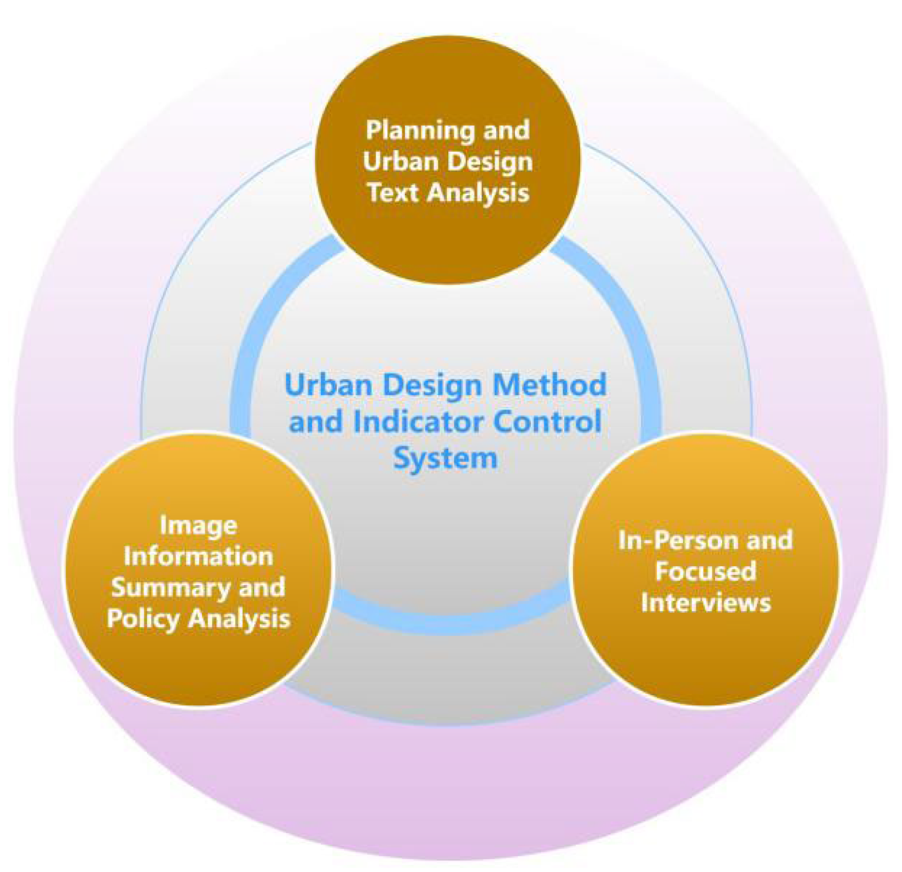


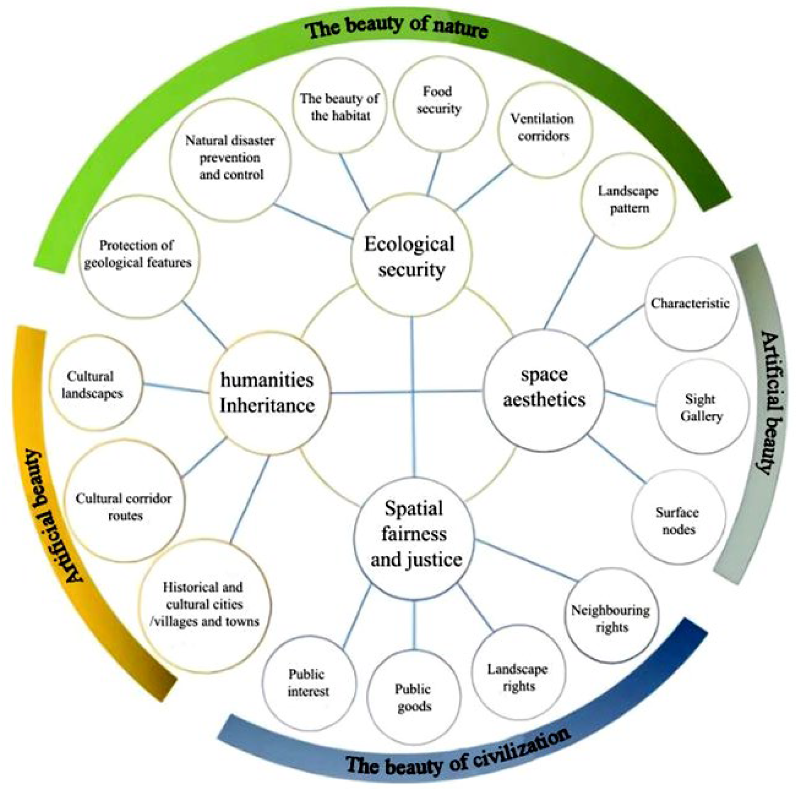
