1. Introduction: Ancestral Hall of Lechang, Guangdong (Canton) Province, China
The architecture of ancestral halls plays a vital role in traditional Chinese villages. It extends beyond mere physical structures and serves as a conduit for the spiritual realm of the villagers. This article explores the intricate architecture of ancestral temples, encompassing clan temples founded on blood ancestor worship, and the architecture of temples based on geo-folk beliefs. In Guangdong, ancestor worship and ancestral halls hold great significance, with every settlement boasting its own ancestral halls. As a place of worship for common ancestors and a hub for clan members to gather and deliberate, ancestral halls embody the Confucian principle of filial piety.
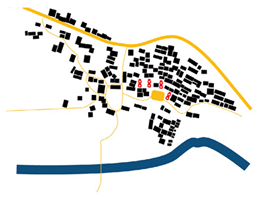
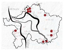
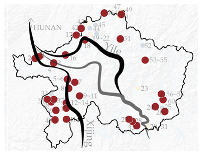
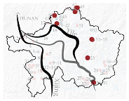
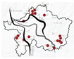
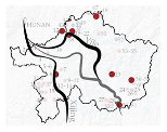
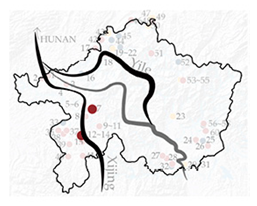
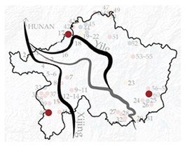
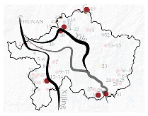
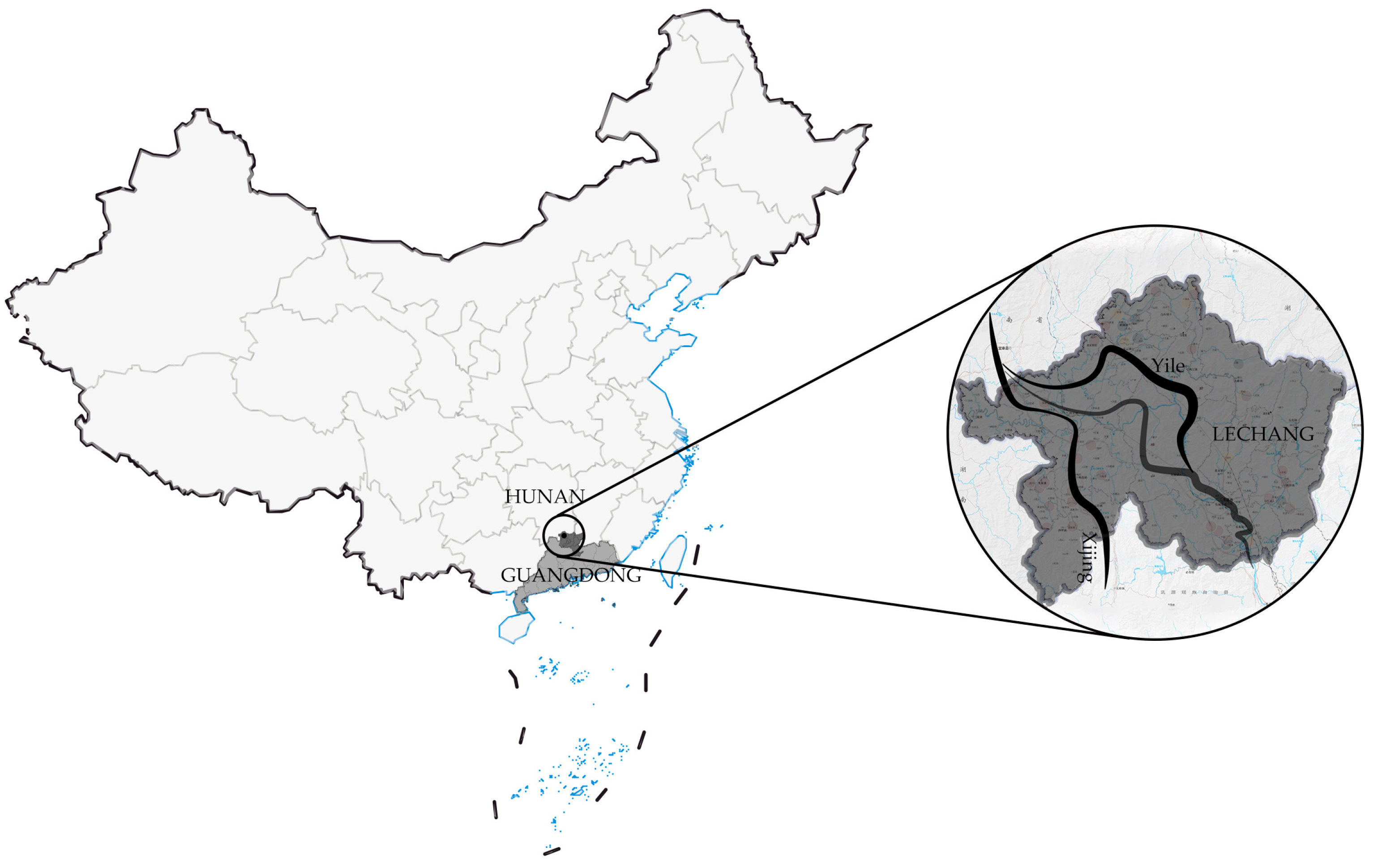
The Lechang Region, situated at the intersection of Hunan and Guangdong Provinces, boasts a well-established network of ancient roads [
1] that has greatly influenced the architectural styles of Hakka, Guangfu, and Hunan.
Within the region, two prominent ancient roads exist: Yile and Xijing (
Figure 1). Yile Ancient Road, which connects Yizhang County in Chenzhou, Hunan Province, to Lechang City in Shaoguan, Guangdong Province, was excavated in the Qin Dynasty (221–207 B.C.) and was later remodeled during the Eastern Han Dynasty (25–220 A.D.). During the late Ming and early Qing dynasties (1628–1700 A.D.), many porters chose to use this road as a way to avoid the salt tax when the government imposed a sea ban, solidifying the Yile Ancient Road’s significance. The Yile Ancient Road played a vital role in the logistical hub of Lechang City, enabling the transportation of tribute commodities from Lingnan and foreign products to the Central Plains, as well as the transportation of silk from the Central Plains to Guangzhou and even overseas markets. The road utilized Wushui for waterway transport, making it the primary water transport route in the Lechang area.
The Xijing Ancient Road, which has a lower terrain than the Yile Ancient Road, has been a vital transportation network for centuries. Its origins date back to the Eastern Han Dynasty and it was later established as an official trade route during the Tang Dynasty. As the primary channel for official tribute and trade, it greatly stimulated the economic development of the surrounding areas. During the Ming and Qing Dynasties, the ancient roads gradually developed into private trade routes. With the guidance of government policies and the influx of immigrants, commerce and trade activities thrived. These two ancient routes played a crucial role in promoting exchanges between inland and overseas, strengthening communication and governance between localities and the central government, and promoting the local economic and cultural development of Lingnan.
In order to preserve the traditional cultural heritage embedded in clan architecture, it is crucial to maintain a diverse range of building types within the culture-bearing clan architecture system. Traditional clan architecture must undergo adaptive evolution from the perspective of urban and rural evolution and future living needs. However, this poses a contradiction with inheritance itself. Currently, Lechang is facing an economic challenge, making it difficult to pass on local traditional architecture. It is imperative to establish a research system on the architectural types of ancestral halls in atypical areas, clarify the local architectural types, and contribute to the sustainable development of architecture.
In the 21st century, experts exploring cultural routes or heritage corridors have posited that they represent a multifaceted manifestation of cultural heritage [
2].
The concept of cultural routes was first introduced in Europe in the 1960s. The Council of Europe’s expert group on “L’Europecontinue” submitted a report entitled “Integrating Europe’s important cultural heritage into the leisure culture of its inhabitants”, which proposed the rediscovery of a common heritage through tourism. This aimed to promote cultural interaction, inter-religious dialogue, and the preservation and development of landscapes, ultimately strengthening cultural cooperation [
3]. China’s Cultural Routes Heritage [
4] includes several significant routes, such as the Shu Road, the Grand Canal, the Silk Road [
5], the Maritime Silk Road, the Southwest Silk Road, the Beijing Axis, the Ancient Tea and Horse Trail, the Ancient Chuanyanese Salt Road, the Ten Thousand Miles Tea Route, and the Wudang Sacred Path. This paper focuses on the ancient stagecoach route in Southern Guangdong, an essential part of China’s cultural heritage. An integral aspect of this heritage is the ancestral halls situated along these pathways, which have garnered greater interest in their architectural designs. Recently, scholars have scrutinized the settlements lining various routes of the Guangdong historical trail, spurred by the trail’s burgeoning protection and adaptive use. Lu Qi et al. identified diverse village forms and architectural styles along the ancient routes in eastern, western, and northern Guangdong and the maritime routes [
6]. On a similar note, Pan Ying et al. conducted morphological analyses of traditional settlements along the Xijing Ancient Route [
7], the Meiling Ancient Route [
8], and the Lianzhou Fengyang–Dongbei Ancient Route [
9].
The School of Architecture at the South China University of Technology is dedicated to conducting long-term research on traditional architecture in Lingnan. In the 1980s, Professor Lu Yuanding compiled the “Guangdong Folk Habitat” through extensive research on villages, analyzing the layout of Guangdong folk dwellings and summarizing the initial formation of the Guangdong rural settlement research system [
10]. Recently, Professors Cheng Jianjun and Zhu Xuemei led a research team in a comprehensive and in-depth study of ancient architectural technology and its source flow in Lingnan [
11]. They focused on the frame style, structural characteristics, construction technology, material technology, and the source flow of ancient architecture. Meanwhile, DanChen et al. from Guangdong University of Technology studied the characteristics and distribution of Tulou in Chaozhou [
12]. While ancient architecture research has primarily focused on construction and combing, there is a lack of studies on overall architectural form and spatial distribution characteristics.
The use of quantitative analysis in the study of traditional architecture articles is not yet prevalent. While GIS technology and SPSS 26 analysis software are widely adopted, most existing research is focused on urban and rural planning and landscapes. However, some scholars, like Professor Xiao Dawei at the South China University of Technology, are exploring the characteristics of traditional villages through multidisciplinary cross-research methods, such as cultural geography [
13]. Experts like Yang Xin and Professor Tang Zhaohui are also using SPSS statistical analysis to investigate the forms of Hakka residences in Heyuan [
14].
Current research focuses on developing a comprehensive research system for traditional settlements along Guangdong’s ancient roads. However, it is essential to note that multicultural phenomena also exist in settlements along single ancient roads, an aspect that has received less attention. To address this gap, Chang Qing of Tongji University; Lu Qi of South China University of Technology; Xiao Dawei, Pan Ying, and Li Xiaofeng of Huazhong University of Science and Technology; and Tan Gangyi, Zhao Kui, and Meng Xiangwu of Lanzhou Polytechnic are collaborating on a study that delves into the classification of ancestral halls along the ancient roads in this complex multicultural intertwined area. Their research will focus on the architecture of ancestral temples along the ancient roads in the multicultural intertwined area to achieve a better understanding of this dynamic and diverse region.
This paper employs quantitative methods to establish a research framework for the characteristics of traditional architectural forms, drawing on existing research in the field. Through SPSS analysis software, this study investigates the relationship between various factors, identifying three levels of characteristics: settlement, architectural form, and spatial decorations. These serve as the basis for classifying research data, which are then used to refine variable factors in architecture. The resulting architectural coordinate and variable information EXCEL file is entered into a GIS online map, allowing for the analysis of variable distribution. Ultimately, the data are processed using SPSS software to determine style classification. By objectively summarizing the architectural form and spatial characteristics of ancestral temples along ancient roads in Lechang City, this study represents a significant breakthrough and further exploration of traditional architectural characteristics.
The upcoming sections of this study draw upon research in terroir architecture [
15] and cultural geography [
16]. Its primary goals are as follows: 1. to extract and analyze the information on various levels of the ancestral hall buildings, using AHP hierarchical analysis to determine the relative importance of each level; 2. to classify the architectural features using SPSS cluster analysis; and 3. to examine the geographic distribution of different ancestral hall types along the ancient paths, leveraging GIS technology. Throughout the process, speed, objectivity, and generalizability were prioritized.
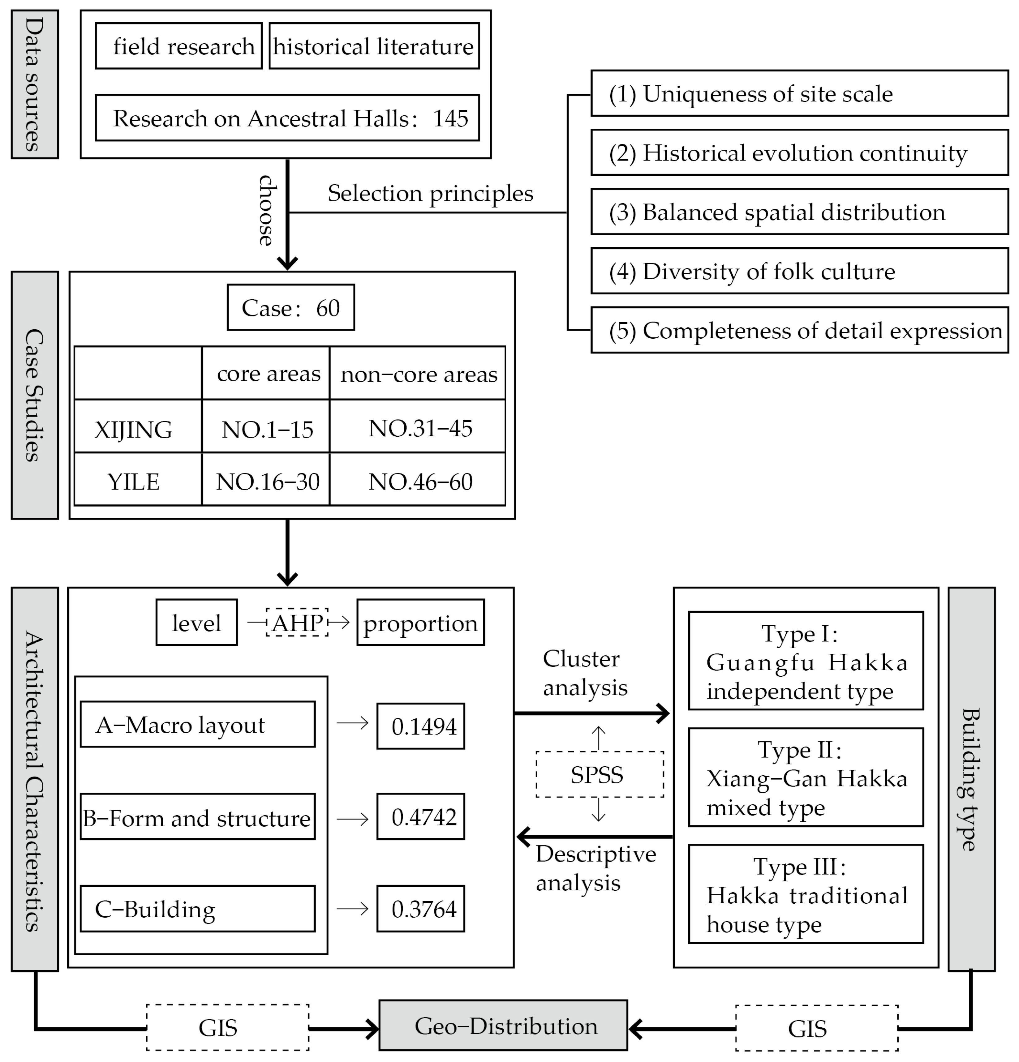
2. Methods: Construction of the Indicator System
This paper employs quantitative methods to establish a research framework for the characteristics of traditional architectural forms, drawing on existing research in the field.
STEP 1: The core research subjects were selected from the historical literature and field research data.
STEP 2: Through SPSS analysis software, this study investigated the relationship between various factors, identifying three levels of characteristics: A—macro layout, B—form and structure, and C—building symbols. These serve as the basis for classifying research data, which are then used to refine variable factors in architecture.
STEP 3: AHP analysis was used to determine the importance of different levels.
STEP 4: The resulting architectural coordinate and variable information EXCEL file was entered into a GIS online map, allowing for analysis of variable distribution.
STEP 5: The data were processed using SPSS software to determine style classification. By objectively summarizing the architectural form and spatial characteristics of ancestral halls along ancient roads in Lechang City, this study represents a significant breakthrough and further exploration of traditional architectural characteristics (
Figure 2).
2.1. STEP 1: Data
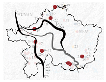
The “Guangdong Cultural Heritage, Immovable Cultural Relics List” documents 145 provincial-, municipal-, and county-level ancestral halls. Their Google Earth locations were determined. The ancient road was then divided into two levels, core and non-core, based on the straight-line distance from the route on Google Maps. This research focused on these levels, selecting local government-licensed ancestral halls for protection and mapping the value of other halls. After several field visits, 60 traditional villages were chosen as research sites, with 15 in the core areas of the Yile (Y) and Xijing (X) ancient roads and 30 in non-core (NC) areas. These villages had complete structures, well-preserved walls, and strong links to the stagecoach routes (
Table 1). A preliminary study of an ancestral hall along the ancient road was conducted by analyzing GIS drop maps and establishing a database of ancestral temple building types along the route.
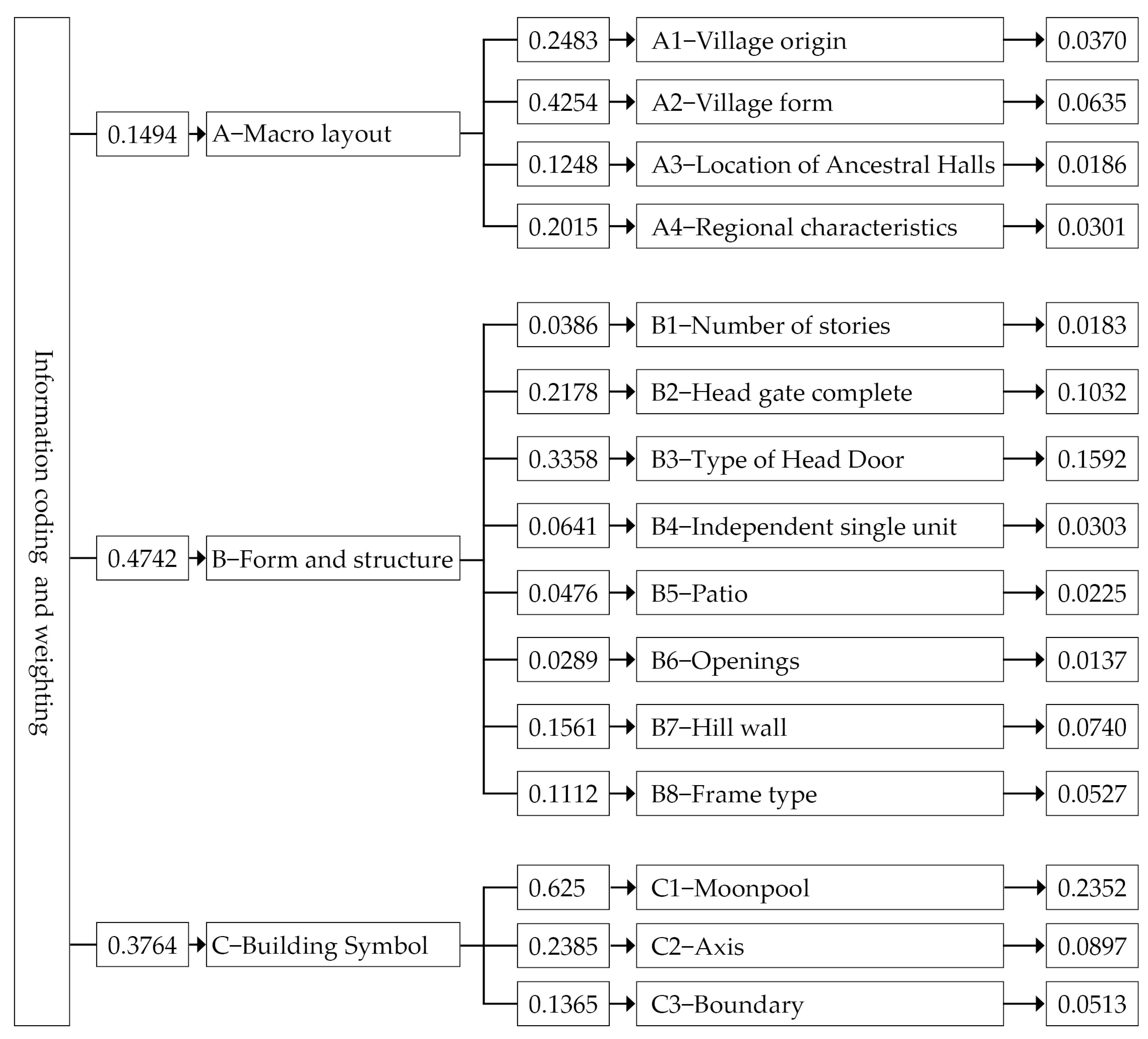
2.2. STEP 2: Establishment of Hierarchical Model and Assignment of Morphological Features of Ancestral Temples
When examining the architecture of villages and other related morphological features, one may utilize various techniques in assigning weights. Among these techniques are hierarchical analysis [
17], fuzzy comprehensive evaluation, the Delphi method, the entropy value method, and principal component analysis [
18]. Hierarchical analysis stands out for its ability to combine quantitative and qualitative analysis, resulting in a more flexible approach than other methods. By avoiding the overly mechanistic limitations of pure quantitative analysis, and overcoming the overly subjective limitations of pure qualitative analysis, hierarchical analysis is the preferred method for assigning weights to this indicator system.
This study combines research by Prof. Chang Qing of Tongji University, China, who categorized the indicators into five aspects: “settlement form”, “house type”, “structural characteristics”, “decorative techniques”, and “construction taboos” [
15]. Combined with field research and fixed-point labeling with ArchGis, the target layer is the study of ancestral temple building types in the study of generalization. The element layer consists of three key indicators: settlement layout at the macro level, architectural form at the meso level, and spatial symbols at the micro level. Moving to the indicator layer, the settlement layout includes four indicators: the origin of the village where the ancestral hall is located, the form of the village, the location of the ancestral hall, and the regional characteristics. The architectural form includes eight indicators, such as the number of floors, the completeness of the head gate, the type of head gate, the independence of the individual unit or not, the number of patios, the openings, the type of mountain walls, the type of framing, and the spatial symbols like the moon pond, the axes, and the boundaries. This model diagram is hierarchical and labeled accordingly in
Table 2. In the upcoming section, various buildings along the route to extract relevant variables are examined, and a detailed analysis of their relationship to the forms is provided.
2.3. STEP 3: Creating a Weighted Judgment Matrix
The importance of various evaluation criteria cannot be treated equally. Therefore, their respective results cannot be summed up directly. Instead, a weighted average based on the degree of importance is required. To determine the relative weight value of each indicator that influences the classification of ancestral halls, this paper devised an AHP questionnaire using a well-established structural hierarchy model. This model features a target layer, an element layer, and an indicator layer, making it easy to visualize the classification of each ancestral hall.
This method relies on the hierarchical structure diagram of evaluation indicators outlined in the ancestral hall type-division study. It compares the significance of each indicator within the same structural level [
19]. To eliminate any potential confusion regarding the evaluation indicators, a seven-level scale is employed to ascertain their values. The evaluation matrix uses numbers 1–7 and their inverses as the scales.
The process of determining the AHP weighting information relies on the decision maker’s assessment of the relative importance of the indicators in the structural model, i.e., the weights. In this study, experts and scholars in urban and rural planning, architecture, and architectural history were invited to participate (
Table 3) in both online and offline questionnaires to evaluate the relative importance of the 3 element-level indicators and 14 indicator-level indicators in the scoring system [
20]. We determined the degree of importance of each first- and second-level factor indicator, constructed judgment matrices, conducted consistency analysis, and assigned indicator weights. The experts’ evaluation results were comprehensively assessed, and an evaluation matrix was created for each level. A consistency test was then conducted to achieve more authoritative and objective importance ranking results for each evaluation index. By enhancing the accuracy of the weights, the study also made it easier to compare the different attribute indicators of ancestral halls.
To generate expert scoring results, all the expert judgment matrices were entered, and then counted to form the final judgment matrix. Four statistical methods were used: the geometric mean algorithm, the arithmetic mean algorithm, the eigenvector method, and the least-squares method. In this study, it was found that the results of the first three calculation methods were consistent, while the last method had a slight deviation. The geometric mean method is the most common, and thus, this paper adopted this method to produce the final judgment matrix [
21].The formula for calculating the geometric mean is as follows:
where is the degree of importance of indicator i to indicator j in each expert’s evaluation, and n is the number of experts.
Then, the column-wise normalization was performed to obtain its feature vector:
The final weighting coefficients for each factor were obtained as follows:
Expert scoring results may cause local weight discrepancies that can disrupt the final weight index evaluation and cause inaccuracies in the resulting indicator weights. Therefore, it was necessary to conduct a consistency test of the final judgment matrix of the scoring results of the experts.
The following formula was used to calculate the consistency ratio (CR):
RI is a fixed value in the average random consistency index table, which indicates the degree of freedom. CI is the computed consistency index (consistency index), which is calculated by the following formula:
where n is the matrix order and is the maximum eigenvalue of the judgment matrix, which is given by:
is the ith component of the vector.
If the CR falls below 0.1, the expert evaluations of indicator importance agree. Otherwise, the scoring process was re-evaluated until a CR value of less than 0.1 was achieved. After inputting the scores into the judgment matrix, the final judgment matrix results and weight values were obtained using the geometric mean algorithm.
The final system weight table (
Figure 3) was formed by combining the weight value of the element and indicator levels, resulting in each indicator’s final percentage [
22]. From this analysis, it is evident that the architectural form held the most significant weight in the type-division research, and the next section will focus on examining meso-level architectural form discussions.
4. Discussion
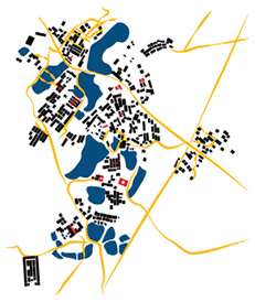
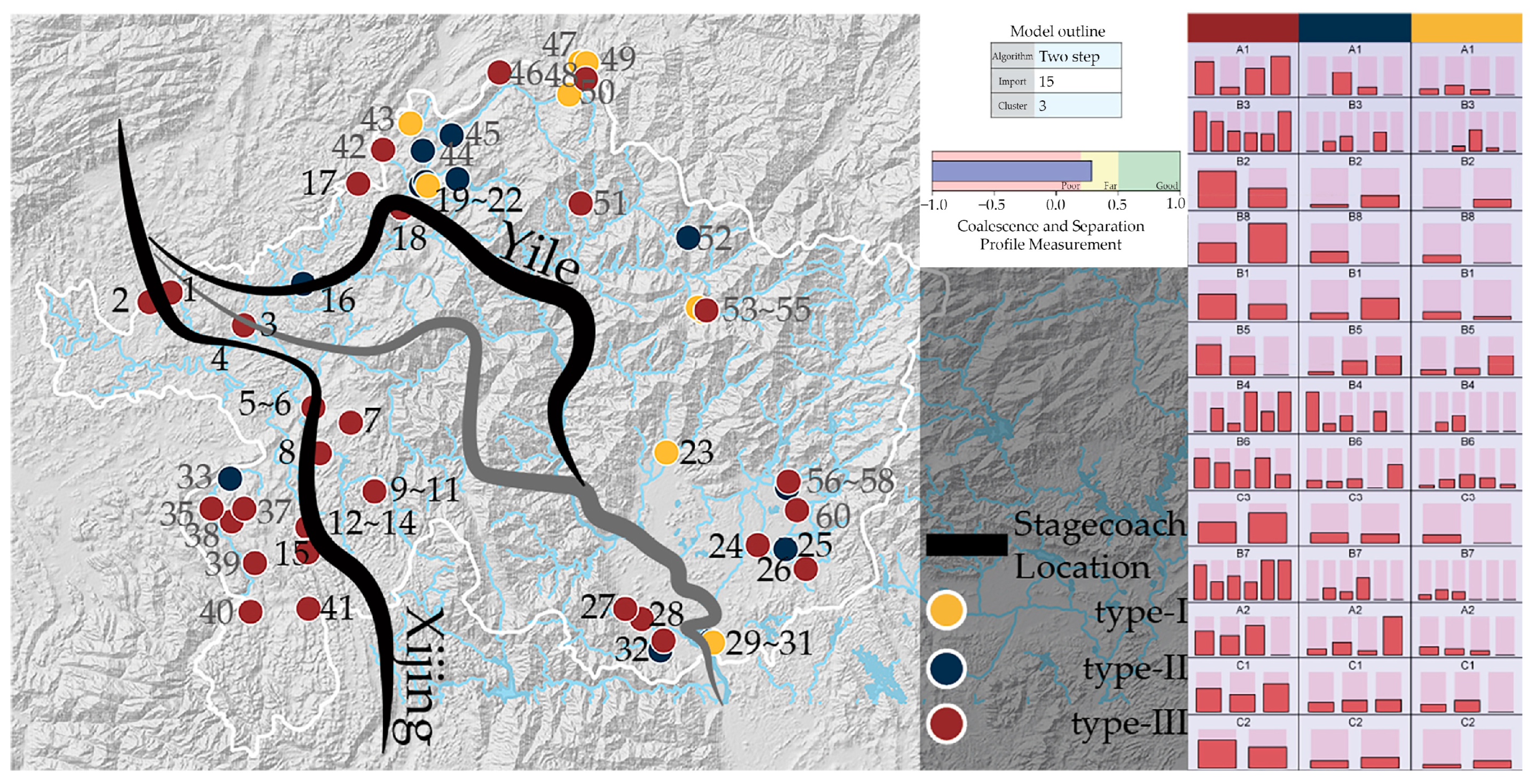
4.1. STEP 5: Basic Classification of Ancestral Hall Buildings along the Route
Second-order cluster analysis is a technique commonly used in data analytics and machine learning to divide a dataset into groups so that the similarity between data points within a group is as high as possible and the similarity between groups is as low as possible. To evaluate the clustering quality of all samples, a second-order analysis was conducted using cluster analysis. This helped determine the number of clusters, resulting in three macro clusters that accurately categorized all individuals. The clustering quality was deemed to be good. It is shown here that it is reasonable to categorize all data into three categories.
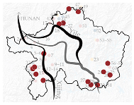
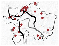
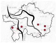
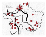
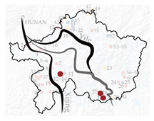
Based on the results of the analysis, K-center cluster analysis was performed on all samples and their geographic locations were identified and labeled on a map (
Figure 4).
In the figure on the right, different colors represent different types, and the proportional distribution of factors (
Table 1) can be seen vertically for different tiers.
Cluster analysis was utilized to integrate the analysis with the judgment matrix weights.
Based on the previous assessment of materiality, the architectural form holds the most significant weight in type-division research. This study combines data quantification methods to categorize the existing architectural indicators. As a carrier of the cultural phenomenon of architectural culture, the clan house buildings that remain along the ancient paths are the real samples of style and culture mapped, so when classifying and naming the different types of buildings, they are named by the local culture and the folk lineage.
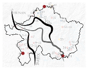
By combining the plane type with its modeling, the zoning range of the ritual building types was approximated along the ancient road in Lechang City. As a result, three distinct architectural styles for ancestral temples were identified in the Lechang City area (as seen in
Figure 4):
- I.
The Guangfu–Hakka independent type;
- II.
The Xiang-Gan–Hakka mixed type;
- III.
The Hakka traditional house type.
After overlaying different variables on the map compiling information on the ancestral halls along the ancient stagecoach road, these halls can be classified into three styles. These include the Guangfu and Hakka mixed style, the Xianggan–Hakka mixed style, and the Hakka style. The mixed style was further divided into two types, namely the Guangfu–Hakka mixed type and the Xianggan–Hakka independent type.
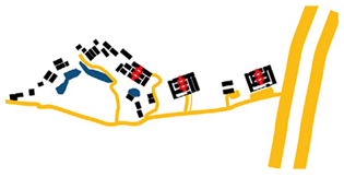
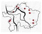
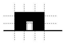
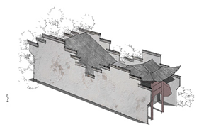
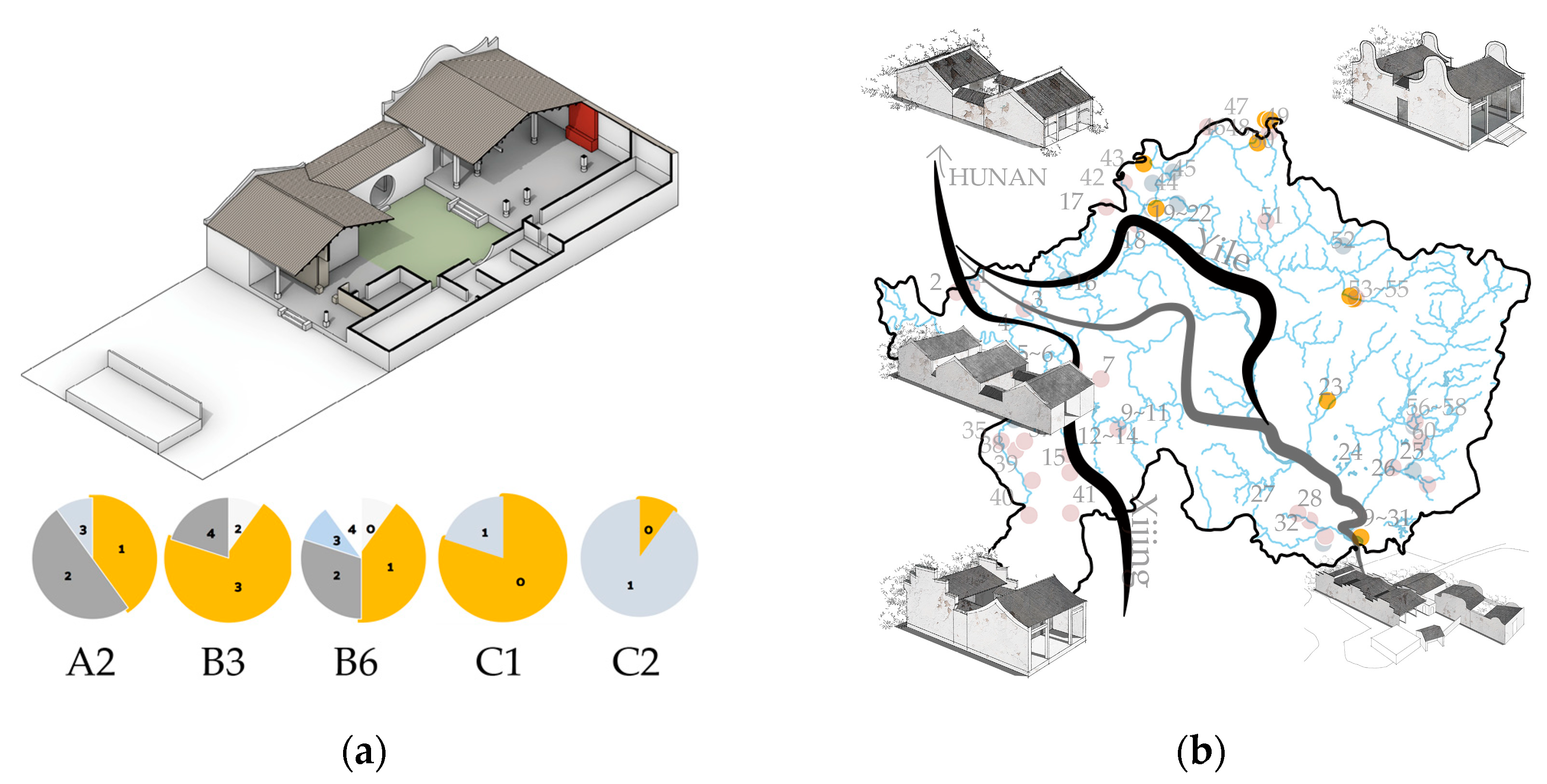
4.2. Guangfu–Hakka Independent Type
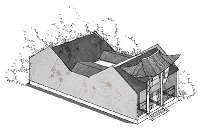
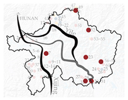
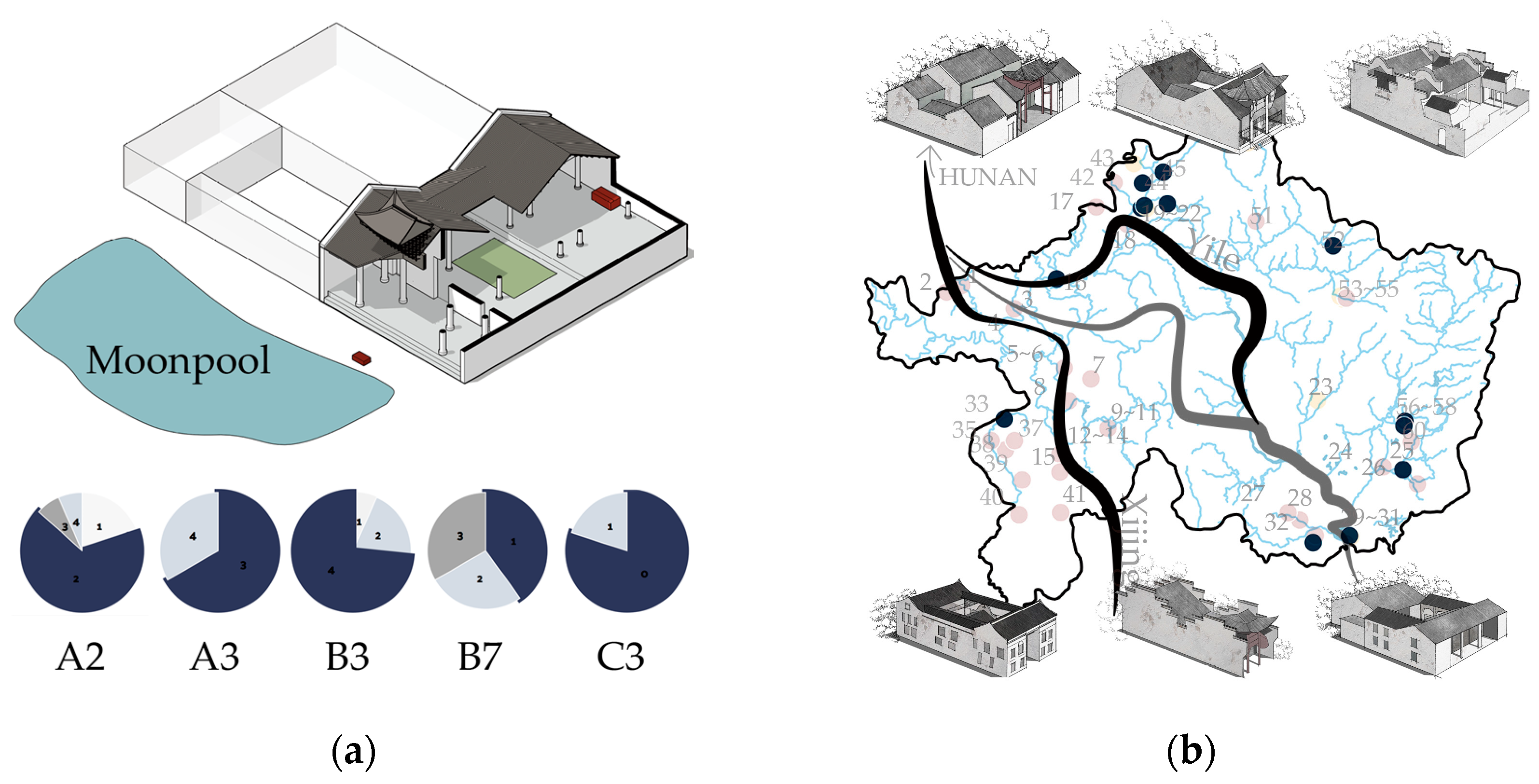
The Guangfu cultural area is centered on Guangzhou, and extends in all directions. Though Lechang is distant from Guangzhou, it remains within the range of the Guangfu style. As a result, a few blended Guangfu and Hakka styles emerged along the Yile Ancient Road (
Figure 5). Hunan’s architectural culture was also assimilated during exchanges with Hunan residents, leading to a distinctive Hunan-style residence and decorative aesthetic in the settlements.
Out of all the samples, 16.7% belonged to this particular type. The variables that defined this type among the available samples are as follows: 50% of the village forms were the strip-story type and 40% were the cluster type. All regional characteristics were from Guangzhou and its surroundings, and 90% of the buildings of this type had only one story. In terms of the relationship between the head gate and the main ritual space, 100% of the head gates were intact. In terms of the type of head gate, 70% were of the Mendang type, and 80% had a single patio.
Additionally, 60% of the openings were three-roomed and 100% of the buildings were free-standing monoliths; 80% did not have moon pools, and 10% showed the phenomenon of the axis being turned around. There were no borders with concave and convex phenomena.
This particular type is mainly distributed in the ancient road farther north of the Yile Ancient Road plateau mountainous environment. Due to the challenges of building a village in the high mountains, only wealthy families could establish large-scale ancestral halls. Therefore, the essence of the cultural characteristics of various ethnic groups was incorporated into options for ancestral hall modeling.
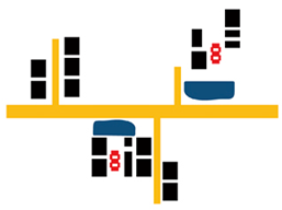
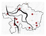
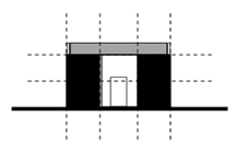
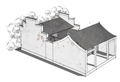
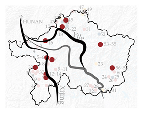
4.3. Xiang-Gan–Hakka Mixed Type
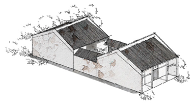
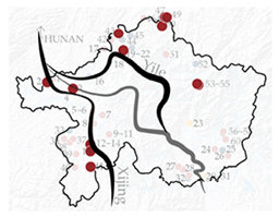
Most of the villages in Lechang, located on the border between Hunan and Guangdong, originate in Jiangxi, Hunan, or other neighboring provinces. Due to its location as a transit point, Lechang has been influenced by migration, and the connection of ancient roads accelerated the spread of the Central Plains culture. When building ancestral halls in the Lechang Section, the clansmen usually invited artisans from Chenzhou, Hunan and Ganzhou, Jiangxi to construct them. As a result, the Lechang Section bordering Hunan, particularly at the end of the Yile Old Road (
Figure 6), showcases the Xiang-Gan culture in its architectural style; 25% of all samples belong to this type.
Of the available data, this particular type is characterized by several variables. Firstly, 80% of the village’s original streams can be traced back to Xiang-Gan, and 66.7% of the village structures are strip-stories. Regarding the number of stories, 53.3% of buildings are of the one-story type, while 46.7 are of the two-story type. Additionally, 93.3% of the head gates are intact, with 73.3% being an alcove-and-dipper type. Most buildings (80%) had three openings, and 60% had single patios. Regarding the hill walls, 46.7% have mixed patterns, but all are free-standing monolithic units, while 66.7% have half-moon pools, and in 13.3% of cases where the axes have undergone a turnaround, the axes are complete while the rest are intact. Finally, 20% of the interfaces demonstrated the phenomenon of concavity and convexity.
This category of structures is situated in the heart of the Yile Ancient Road and maintains a strong link to the historic route. The waterways along the Yile Ancient Road are well developed, facilitating the transportation of various materials. When constructing ancestral halls, migrants would hire artisans from their hometowns, and the convenient waterway system played a crucial role in material transportation.
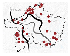
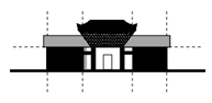
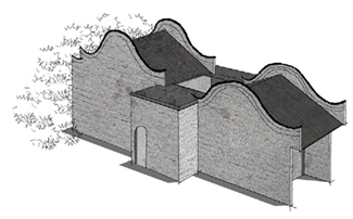
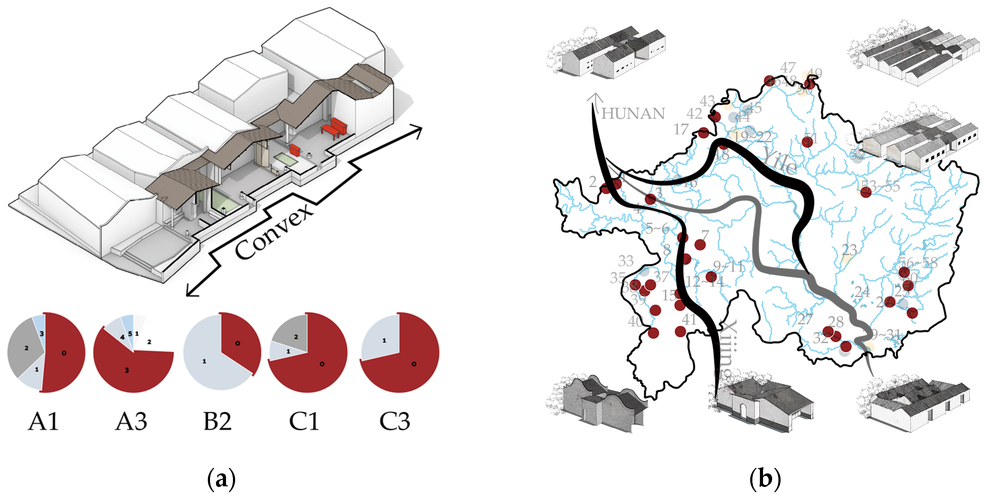
4.4. Hakka Traditional House Type
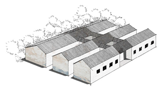
Most of the Hakka community in Lechang originated from Gannan and western Fujian. The local primitive culture also influenced them (
Figure 7). Given the sparse population and the government’s initiative to shelter displaced persons and Hakka refugees fleeing from war, they sought refuge in the fortress-like Tang Heng Houses and Wai Houses [
23]. These structures provided a secure abode to shield them from the constant threat of banditry. In the Lechang area, the Hakka people constructed sturdy enclosure houses to safeguard themselves against a growing population. This eventually led to the distinct and impressive Hakka enclosure house architecture that we see today, with the ancestral hall as the symbol of their unity. The ridge house or the horizontal hall features the front, middle, and back sections. The middle hall was removed in some smaller buildings, leaving only the front and the back halls. As the need for protection waned, the walls were gradually destroyed, leaving only the ancestral hall in the center.
Semi-circular moon ponds or regular pingtongs are typically seen in front of Hakka-style ancestral halls. In contrast, irregular moon ponds or pingtongs are commonly found in front of mixed-style ancestral halls. The village form and the layout of the ancestral hall are interconnected, and the extent of this connection varies based on the geographical locations and cultural heritage. This type accounts for 58.3% of all samples analyzed, with variables such as village origin being significant factors. Of those samples, 51.4% are from the original local inhabitants, and 31.4% are from Hakka migration.
Regarding the various village forms, 45.7% are strip-story, while 34.2% are grouped. As for the number of stories, 85.7% of buildings have only one story, and the remainder have two. Regarding the relationship between the head gate and the main ceremonial space, 65.7% have an intact head gate, while the remaining 34.3% have a disengaged head gate. As for the types of head gates, 28.6% feature concave double doors while another 28.6% have a combination of a doorway and concave double doors. Additionally, 60% of the village structures have a single patio, 34.3% are without a hill wall, and 34.3% feature a herringbone pattern. Furthermore, 74.3% of the structures are free-standing monoliths, 71.4% have half-moon pools, 22.9% have transitions in their axes, and 28.6% have concavities in their interfaces.
Type III can be found all over Lechang, with the ancestral hall structures nestled in the southern mountains along the Xijing Ancient Road. These buildings seamlessly blend with the surrounding terrain and possess a modest scale. Immigrants abandoned the traditional square and round huts and the Tang Yokoyama style in favor of row houses that could be easily combined and uniquely shaped huts that complemented the natural landscape. The result is a distinctive Hakka hybrid architectural style.


