Article

Research on the Construction Method of Cultural Visiting Routes Based on the Coupling Coordination Degree Model: A Case Study of Zhongshan Road Historical and Cultural Block, Xiamen, China

1
School of Architecture and Civil Engineering, Xiamen University, Xiamen 361000, China
2
School of Architecture and Urban Planning, Anhui Jianzhu University, Hefei 230000, China
*
Author to whom correspondence should be addressed.
Buildings 2024, 14(12), 4069; https://doi.org/10.3390/buildings14124069
Submission received: 27 November 2024 / Revised: 17 December 2024 / Accepted: 19 December 2024 / Published: 21 December 2024

Abstract

:
As a form of urban experience tour, cultural visiting routes provide an innovative approach to addressing the fragmentation and isolation of cultural resources in historic districts. This method emphasizes the systematic continuity of cultural spatial patterns and is currently implemented at both regional and urban scales. However, methods for constructing cultural visiting routes at the block scale still require further investigation. And there is a notable lack of studies that consider the integration of multiple systems in cultural visiting routes. Consequently, this research proposes a novel approach for constructing cultural visiting routes based on the coupling and coordination of multiple systems. Using the Zhongshan Road Historical and Cultural Block in Xiamen, China, as a case study, this study develops cultural visiting routes by analyzing the degree of coupling coordination between cultural resource value and the street walking environment. The findings are as follows: (1) The cultural visiting routes within the Zhongshan Road Block can be categorized into three levels: the first-level routes, represented by Zhongshan Road; the second-level routes, represented by Datong Road; and the third-level routes, represented by Park South Road. (2) The first-level cultural visiting routes demonstrate a high degree of coupling coordination, with an optimization direction focused on refined updates. The second-level routes exhibit a medium degree of coupling coordination, indicating an urgent need to address issues across the entire road section. The third-level routes reveal a low degree of coupling coordination, necessitating attention to the enhancement of cultural visiting elements. This study emphasizes that the construction of block-scale cultural visiting routes must prioritize not only the extraction of value from cultural resources but also the influence of the street walking environment.

1. Introduction

The historical and cultural block serves as a crucial medium for shaping the city’s image [1] and currently represents a significant area for heritage conservation research and practice. Numerous “dot-shaped” visiting resources exist within the historical and cultural block. However, surveys indicate that public visitation behavior is generally confined to a limited number of well-known attractions. As a result, tourist visits tend to be scattered, fragmented, and isolated, hindering visitors from developing a systematic and comprehensive understanding of the block [2]. Furthermore, this “dot-shaped” visiting behavior leads to the underutilization of the historical and cultural resources within the block, adversely affecting both the protection and utilization of these cultural assets and the overall development of the historical block. Consequently, a pressing concern in the protection and development of historical and cultural blocks is how to foster a holistic understanding and relevant visitation patterns among visitors.
In recent years, China has witnessed a notable increase in city walking activities. According to the 2023 National Tourism Satisfaction Survey Report of China, city walking ranked first among various tourism modes, demonstrating a clear advantage with a proportion of 82%. This trend presents a potential opportunity for the development of cultural visiting routes. Cultural visiting routes serve as a form of urban experiential tourism, utilizing streets as linear spatial carriers to connect scattered cultural relics, monuments, cultural facilities, modern urban scenic spots, and other cultural resources in an organized manner. These routes address the needs of both sightseeing and urban experiences, highlighting the city’s significant landscapes and cultural characteristics [3,4]. They emphasize the systematic continuity of the cultural spatial pattern [5] and offer a novel approach to integrating dispersed cultural resources.
Cultural visiting routes can be categorized into regional and urban types based on spatial scales. Regional cultural routes are often closely associated with linear cultural heritages, such as the Grand Canal [6], the Great Wall [7,8], and the ancient Tea Horse Road [9,10]. Their primary aim is the comprehensive protection and cooperative development of the region. In contrast, urban cultural routes consist of network structures that connect historical and modern cultural resources within the city [5,11]. These routes emphasize the preservation of cultural resource value and their effective integration with tourism. Notable examples of such practices can be observed in major international metropolises, including Paris, Tokyo, and Seoul. Specifically, urban cultural routes can be categorized into three types based on visitation characteristics [3]: (1) Path-type visiting routes, which connect various cultural sites through specific lines, effectively guiding visitors’ route selection in an intuitive manner. A notable example is the 4 + 4 visit routes in Seoul. (2) Region-type visiting routes, which are based on the principle of value priority, rate various resources in the region with star ratings and encourage visitors to choose their own routes based on the star level map. For instance, Paris is divided into 12 visiting areas. (3) Theme-type visiting routes, which are always centered around a particular story or type of culture, often featuring distinctive thematic elements, such as London’s Ghost Story Tour. This study posits that path-type cultural visiting routes are the most suitable for historical urban areas where resources are concentrated yet require development. Furthermore, these routes can be extended to historical and cultural blocks. As the overall walking environment in the region improves, subsequent stages may consider enhancing the integration of cultural resources within historical and cultural blocks through the development of region-type and theme-type visiting routes.
Previous studies indicate that cultural resources are pivotal in shaping a city’s local identity and enhancing the resilience of historic districts [4,12]. The protection and effective utilization of these resources in historic and cultural districts can successfully preserve the historical continuity and cultural diversity of a city [13]. In exploring cultural resources, establishing a suitable value assessment model can provide significant support [14,15]. The integration of cultural resources with the tourism industry is advantageous for the sustainable development of historical blocks [16]. Furthermore, a conducive pedestrian environment is essential to ensure the accessibility of cultural resources [17,18]. A pedestrian-friendly environment can attract both tourists and investment, which can foster the preservation of cultural resources and the growth of the tourism sector [17]. Consequently, a well-connected, walkable, and accessible pedestrian environment is as vital as the cultural resources themselves [19,20,21]. As early as the last century, new urbanism and landscape urbanism proposed an urban design framework that emphasizes density, walkability, and mixed-use development [22,23], viewing cities as semi-network structures composed of various nodes and linear elements [24,25]. This framework established a model language based on location, network, and process for subsequent studies on walkability [26]. Currently, research on walkability encompasses the analysis of factors influencing the pedestrian environment [27], the evaluation of street environment suitability [28,29,30,31,32,33], the design of walkability [34], and the application of big data and machine learning [35,36], etc. In designing the pedestrian system, the integration of cultural resources is crucial [12]. It is evident that cultural resources and the pedestrian environment mutually reinforce each other, collectively contributing to the sustainable development of cultural exploration routes.
Overall, previous studies have focused on the construction methods of cultural visiting routes at both regional and urban scales. However, the scientific delineation of cultural visiting routes at the block scale, along with targeted optimization methods for the visiting environment, has not received adequate attention. In the field of research methods, qualitative analysis that emphasizes the significance of cultural resources continues to be the predominant approach for constructing regional cultural visiting routes [37]. However, in the context of developing urban cultural visiting routes, there is a growing trend towards the integration of quantitative methods, including resource value assessment and walking environment evaluation [5]. According to existing studies, the assessment of cultural resource value and the evaluation of the street walking environment are the key systems that influence the development of cultural visiting routes. However, most studies have primarily focused on the evaluation and optimization of individual systems, with limited discussion on the interrelationship between these two systems.
The coupling coordination degree model, a widely employed method for investigating the cooperative development relationships among multiple systems [38,39,40], can be utilized to analyze the interplay between cultural resource value and the street walking environment while also exploring their comprehensive benefits. This model has been extensively applied across various multidisciplinary fields following long-term development, particularly in the study of two or more related systems. Currently, relevant research primarily focuses on the domains of economics, ecology, and management. Therefore, for the coupling coordination degree model to be effectively applied in urban contexts, it is essential to enhance and redefine the model in accordance with the unique characteristics of the discipline and specific research issues. This refinement must ensure that the calculation elements within the model accurately represent each subsystem of the research topic, thereby facilitating a comprehensive analysis of the development of each subsystem and their overall benefits.
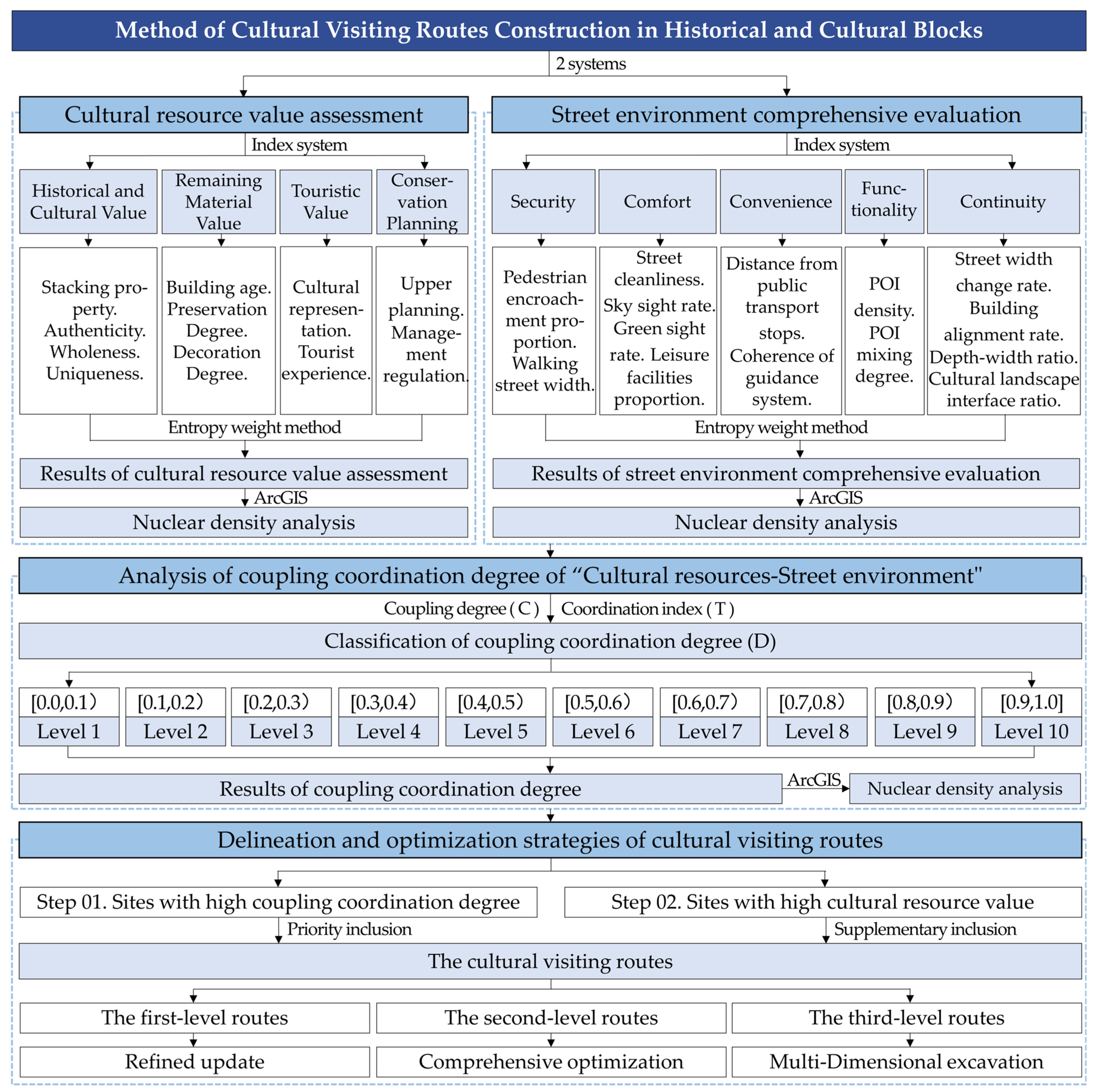
Therefore, this study focuses on the block scale, using the Zhongshan Road Historical and Cultural Block in Xiamen City, Fujian Province, China, as a case study. By disassembling the key constituent elements of cultural visiting routes at this scale, the paper constructed evaluation index systems for both cultural resource value and the street walking environment. Utilizing the existing coupling coordination degree model and integrating the characteristics of cultural visiting routes, we proposed an original application method of the coupling coordination degree specifically tailored for these routes. This study investigated a method for constructing cultural exploration routes based on objective data by analyzing the coupling and coordination relationship between two key aspects. The main research steps include the follow: (1) identifying valuable cultural resources within historical and cultural blocks through material collection and site surveys and developing an indicator system to assess the value of each point; (2) conducting an evaluation of the surrounding street walking environment for each cultural resource site through field investigations and public questionnaires; (3) applying the coupling coordination degree model to analyze the relationship between “cultural resource value” and “street walking environment” at each point; and (4) delineating cultural visiting routes and proposing targeted enhancement strategies based on the results of the coupling coordination degree analysis. The study aims to optimize the method for constructing cultural visiting routes at the block scale and presents specific strategies for implementation.

2. Study Area

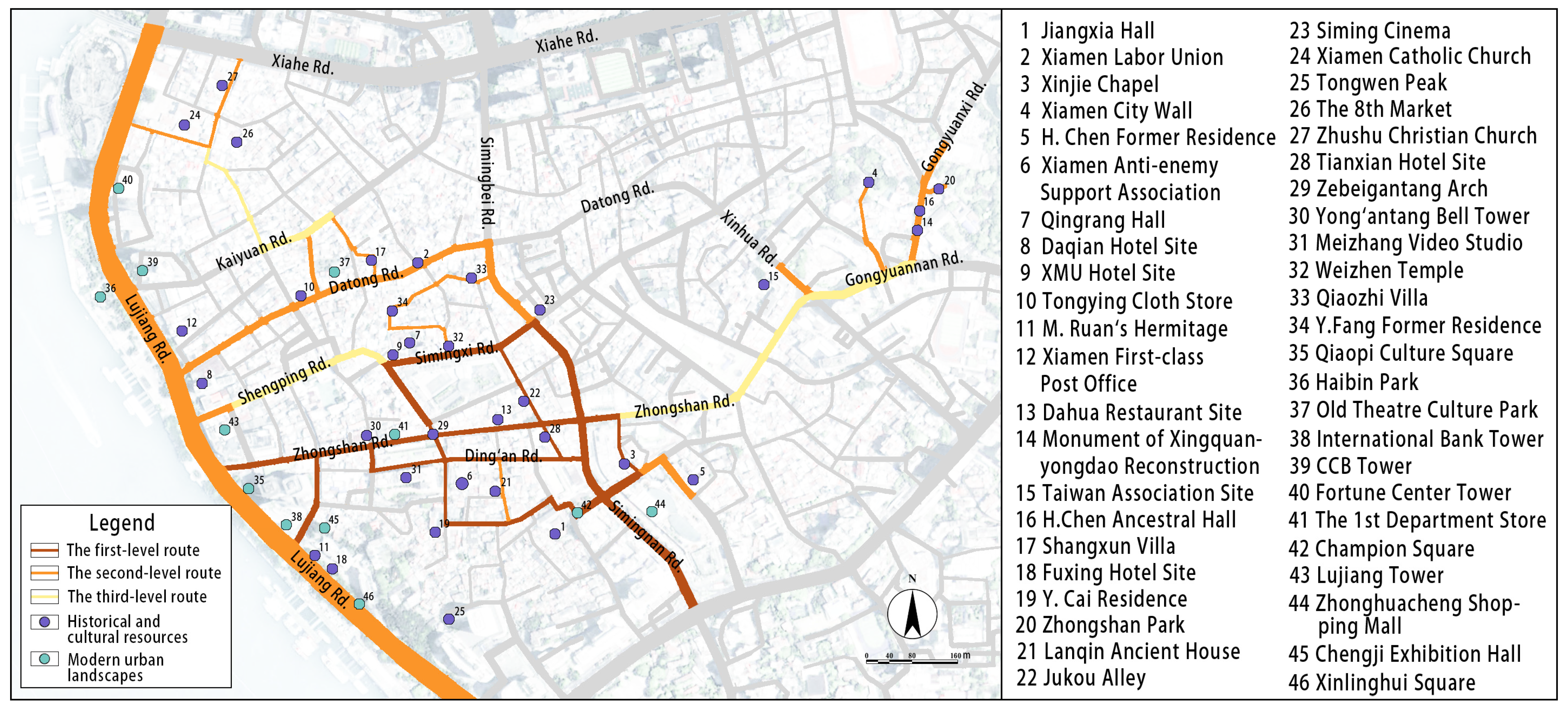
Xiamen City is situated on the southeast coast of China, along the western bank of the Taiwan Strait. It encompasses the mainland area of Fujian Province adjacent to Xiamen Bay, as well as Xiamen Island, Gulangyu Island, and several other islands, as well as Xiamen Bay. This study focused on the historical and cultural block of Zhongshan Road, located on Xiamen Island. In 2020, Xiamen was designated as a historical and cultural city within Fujian Province. The Zhongshan Road Historical and Cultural Block is one of three areas identified in the “Protection Plan of Xiamen Historical and Cultural City (2020–2035)” and covers an area of 125.3 hectares.This block not only serves as a concentration of the historical and cultural resources of Xiamen’s old city but also represents a significant business district that reflects the modern urban style of Xiamen. Rich in maritime trade and southern Fujian culture, the distribution of cultural resources within the block is both fragmented and scattered, underscoring the necessity and typical nature of constructing cultural visiting routes.
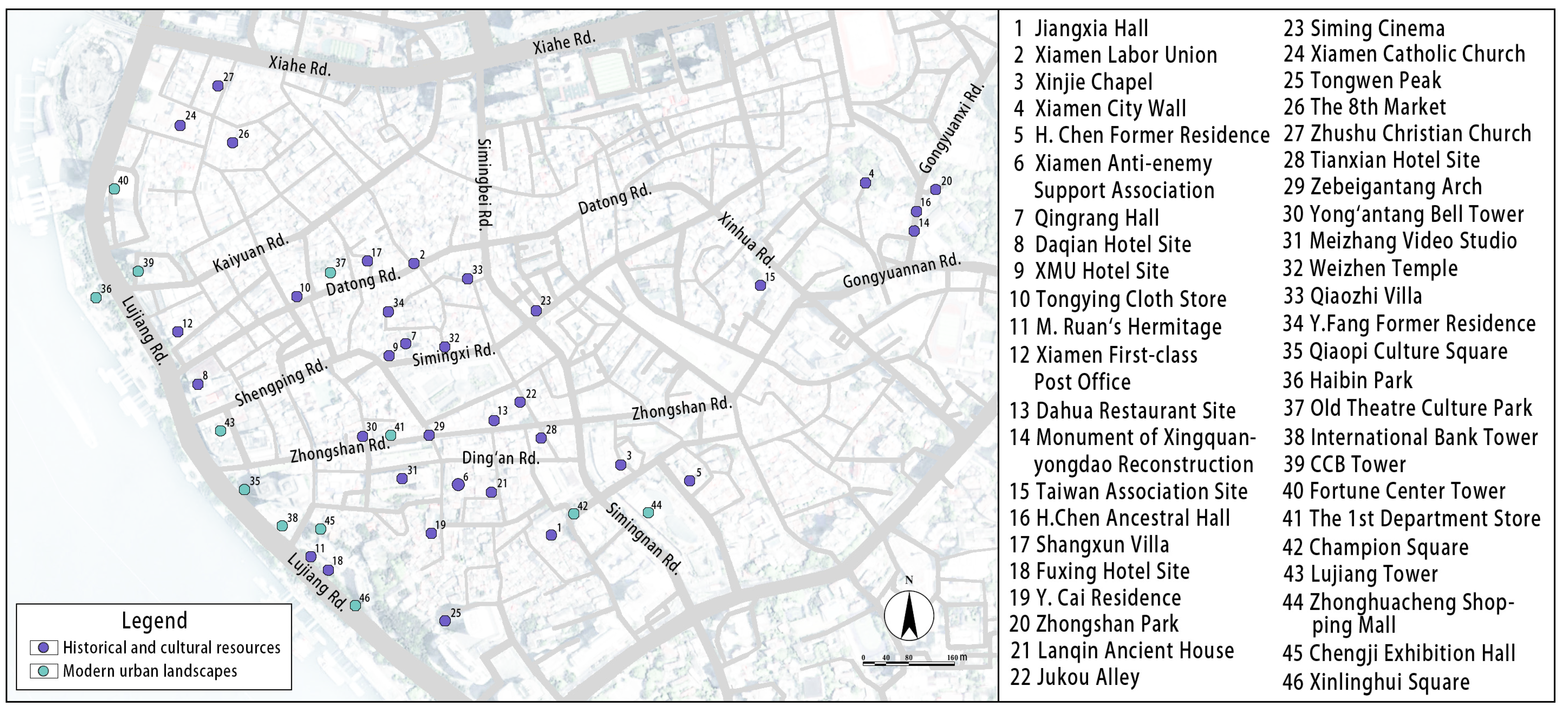
First, the study examined cultural resources through profile consultation and field investigation, encompassing four provincial-level cultural relic protection units, 12 municipal-level cultural relic protection units, three Taiwan-related cultural relic protection units, and several historical style buildings, resulting in a total of 34 historical and cultural resources. Second, 12 modern urban landscapes were selected based on Ctrip’s data of visitor engagement (https://you.ctrip.com/; accessed on 16 December 2023). In total, 46 cultural resources within the Zhongshan Road Historical and Cultural Block were identified (Figure 1).

3. Methodology

3.1. Research Framework

The research framework was divided into four parts (Figure 2). Firstly, this study conducted an assessment and nuclear density analysis of the cultural resource value and the street walking environment of the historical and cultural block. Secondly, the coupling coordination analysis and nuclear density analysis of the “cultural resource value-street walking environment” were performed using the coupling coordination degree model. Thirdly, the study conducted and classified the cultural visiting routes based on the results of the coupling coordination degree analysis. Finally, the paper proposed specific promotion strategies of different levels of cultural visiting routes, informed by the assessment results of cultural resource value and the street walking environment. The primary research methods employed included a literature analysis, field investigation, public interviews, and data analysis.

3.2. Methods

3.2.1. Selection of Cultural Resource Value Assessment Index

Cultural visiting routes possess multiple attributes, including heritage protection and tourism engagement. Consequently, the cultural resource value can be assessed from various dimensions, such as architectural remains, visitor experience, and protection status. Building upon existing assessment models, this article selected 7 key indicators: authenticity, wholeness, uniqueness, building age, preservation degree, decoration degree, and cultural representation. However, the building age index solely reflects the construction period of each site, neglecting the historical and cultural information generated through the accumulation of various stages. To address this limitation, this paper introduced the stacking property index, derived from historical urban landscape methodology, to capture their layering value. Furthermore, acknowledging that cultural visiting routes encompass more tourist-oriented attributes than traditional cultural protection, the study incorporated the indicator of tourist experience. Additionally, to provide a more accurate reflection of the protection and planning status of each site, the indicators of upper planning and management regulations have been included. Eventually, this study proposed an assessment index system that consists of 4 major evaluation layers and 13 evaluation indicators. These indicators encompass historical and cultural value, relic status, tourism value, and protection condition (Table 1).
The paper established a scoring framework for evaluating the cultural resource value, considering the unique characteristics of the Zhongshan Road Historical and Cultural Block (Table 2). During data collection, the historical and cultural resources were assessed using all relevant indicators to compute their resource value, while the modern urban landscapes were evaluated solely based on the “tour value” assessment layer. Specifically, (1) in accordance with the List of Intangible Cultural Heritages outlined in the Protection Plan of the Zhongshan Road Historical and Cultural Block in Xiamen City, the indicator of “cultural representativeness” is categorized into ten types: commercial culture, arcade house culture, maritime culture, overseas Chinese culture, Fujian–Taiwan culture, European culture, art culture, religious culture, celebrity culture, and the remittance culture of overseas Chinese. (2) The assessment results regarding the “preservation degree” of reconstruction points should be assigned a lower level of significance.

3.2.2. Selection of the Street Walking Environment Evaluation Index

The guidelines for the “Planning and Design of Urban Walking and Bicycle Traffic System (2013), China” propose that the walking environment should promote principles of safety, continuity, comfort, convenience, and connectivity. Accordingly, the study thoroughly considered the requirements of cultural visiting routes on street walking conditions and identified 17 universal indicators for evaluating the street walking environment. These indicators include the following: pedestrian encroachment proportion, walking street width, street cleanliness, sky sight rate, green sight rate, leisure facilities proportion, distance from public transport stops, coherence of guidance system, POI density of catering facilities, POI density of accommodation facilities, POI density, POI mixing degree, street width change rate, building alignment rate, depth–width ratio, slope gradient, and cultural landscape interface ratio.
To ensure that the evaluation indicators are more appropriate for the specific context of the Zhongshan Road Historical and Cultural Block, this study employed data review and questionnaire collection to screen 17 indicators. (1) Analysis of the slope data for Xiamen City revealed that the pedestrian slope within this block is less than 5°, categorizing it within the walking comfort classification. Consequently, the impact of slope gradient on the walking environment of the block is minimal, resulting in the exclusion of this index. (2) To more accurately capture public perceptions regarding the Zhongshan Road Historical and Cultural Block, the study designed and distributed the questionnaire titled “Survey of Factors Affecting the Walking Experience of Zhongshan Road Historical and Cultural Block in Xiamen”, which gathered public evaluations of the importance of 16 evaluation indicators. Through simple random sampling, a total of 134 questionnaires were collected, of which 122 were deemed valid, resulting in an effective response rate of 91.04%. Based on the results of the public survey, the indexes of POI density of catering facilities and POI density of accommodation facilities were excluded. Consequently, the study developed an evaluation index system for the street walking environment of the Zhongshan Road Historical and Cultural Block, comprising 5 evaluation layers: safety, comfort, convenience, functionality, and continuity, along with a total of 14 evaluation indexes (Table 3).
Particularly, (1) since the influence of the “depth-width ratio” index is not strictly positive or negative. Consequently, this study referenced Yoshinobu Ashihara’s explanation of the depth–width ratio, defining the scoring system as follows: aspect ratio results greater than 1 and less than 2 receive 3 points; ratios greater than 0.5 and less than 1, or greater than 2 and less than 2.5, receive 2 points; and ratios less than 0.5 or greater than 2.5 receive 1 point. (2) Positive indicators include walking street width, green sight rate, sky sight rate, leisure facilities proportion, POI density, POI mixing degree, coherence of guidance system, cultural landscape interface ratio, building alignment rate, and depth–width ratio. In contrast, negative indicators include street cleanliness, pedestrian encroachment proportion, distance from public transport stops, and street width change rate.
During the data collection process, (1) the evaluation scope of “the street walking environment” encompasses the street space extending from the main entrance of each site to the adjacent urban road. (2) For sites located along urban roads, the scope of the street space encompasses an area extending 80 m on both sides of the urban road, with the site location serving as the center (Figure 3).

3.2.3. Calculation of Index Weights

In the evaluation of cultural resource values and the street walking environment, it is essential to determine the index weights. This study employed the entropy weight method to objectively calculate these weights. Based on the entropy value of each index, the degree of dispersion for each index was assessed, leading to the determination of the corresponding index weights [41,42].
First, the original data are standardized using the range method.
X i j = X i j m i n   ( X i j ) max ( X i j ) m i n   ( X i j )   ( Positive index ) ,   X i j = m a x   ( X i j ) X i j max ( X i j ) m i n ( X i j )   ( Negative index )
In the formula, Xij is the original index data matrix; Xij represents the data of the j-th value assessment index or the street walking environment index at point i; and max(Xij) and min(Xij) represent the maximum and minimum values of the j-th index, respectively.
Second, the index of information entropy is determined.
Y i j = X i j X i j
e i j = 1 l n j ( Y i j × l n Y i j )
In the formula, Yij is the standardized data matrix, and eij represents the index entropy.
Finally, the index weight is determined as follows:
W i = 1 e j j = 1 n ( 1 e j ) ,   i = 1 ,   2 ,   3 n
In the formula, Wi represents the objective weight of the i-th index.

3.2.4. Calculation of Coupling Coordination Degree

The study posits that cultural resource value and the street walking environment are the two primary constituent systems of cultural visiting routes. A high degree of coupling and coordination between these two systems is essential for the effective development of cultural visiting roads. Consequently, this paper employed the coupling principle from physics and utilized a coupling degree model derived from the concept of capacity coupling. By redefining each component in the existing coupling coordination degree model, the study constructed the model to assess the coupling coordination degree between cultural resource value and the street walking environment.
Coupling degree refers to the extent of interaction between two or more systems [38,39]. The coupling degree model between cultural resource value and the street walking environment is expressed as follows:
C = 2 U ( x ) U ( y ) U x + U ( y ) 2 1 2
In the formula, C represents the coupling degree, which ranges from 0 to 1. U(x) and U(y) denote the scores of cultural resource value assessment and street walking environment assessment, respectively.
However, the coupling model fails to adequately represent the degree of coordinated development between these two systems. It is possible for the values of cultural resources and the quality of the street walking environment to be low while still exhibiting a high degree of coupling. To address this limitation, this study introduces a coordination index that more accurately reflects the comprehensive development level of these two systems [20,40]. The formula is as follows:
T = α U x + β U ( y )
D = C × T
In the formula, T represents the comprehensive development index of cultural resource value and the street walking environment. This study posits that the value of cultural resources and the street walking environment are equally significant for the construction of cultural visiting routes, thus setting α = β = 0.5. D denotes the degree of coupling coordination.
To clearly delineate the differences in coupling coordination degree, this study classified the D values of coupling coordination degree based on prior research (Table 4) [40,43]. A higher level of coordination indicates a superior comprehensive development level of both cultural resource value and the pedestrian environment, which is more conducive to the establishment of cultural visiting routes.
While the coupling coordination degree model addresses certain issues inherent in the coupling degree model by incorporating the coordination index, it still presents limitations. A high coupling coordination degree indicates that both systems are performing well, whereas a low degree suggests poor performance in both systems. However, when the coupling coordination degree is at a medium level, the behavior of the two systems may be categorized as “medium-medium”, “high-low”, or “low-high”. In such cases, the specific situation cannot be clearly distinguished solely based on the numerical value of the coupling coordination degree. Therefore, it is essential to further integrate the subsystem scores when constructing the cultural visiting routes.

3.2.5. Nuclear Density Analysis

The study employed ArcMap 10.8 to conduct a nuclear density analysis of the assessment results concerning cultural resource value, the street walking environment, and the degree of coupling coordination, ultimately generating a visual representation within the street network. Firstly, the evaluation data for cultural resource value assessment, the street walking environment, and coupling coordination degree for each site were treated as the population field, with the values of the field weighted for the analysis. Subsequently, the distance to the weighted mean center of all points was calculated, along with the weighted median (Dm) of these distances. Finally, the weighted standard distance (SD) was computed. According to the operational principles of nuclear density analysis as outlined by ArcGIS Pro (https://pro.arcgis.com/; accessed on 6 September 2024), the formula for calculating the search radius is as follows:
S e a r c h   R a d i u s = 0.9 × m i n S D ,   1 ln 2 × D m × n 0.2

3.2.6. Delineation and Optimization of Cultural Visiting Routes

Prioritized the road sections characterized by a coupling coordination degree of “cultural resource value-street walking environment” within the coordinated interval when constructing the cultural visiting routes of the Zhongshan Road Historical and Cultural Block. These routes exhibit the highest cultural resource value and the most favorable street walking environment in the area. Next, sites that possess significant cultural resource value but are situated in areas with suboptimal street walking environment were incorporated into the routes. Finally, to ensure the coherence and fluidity of the cultural visiting routes, it was necessary to connect road sections that have limited cultural resource value but lie between the two delineated routes. Consequently, this study established the final cultural visiting routes of the Zhongshan Road Historical and Cultural Block.
Based on the distribution and significance of cultural resource value, this study categorized cultural visiting routes into 3 levels. The first-level cultural visiting routes demonstrate overall mature visiting conditions and only require minor updates to specific sites or sections to address existing issues. The second-level cultural visiting routes are characterized by varying degrees of cultural resource value and street walking environments, which may exhibit either a “high-low” or “low-high” coordination degree. The revitalization of these routes necessitates a comprehensive investigation to develop appropriate strategies for the renovation of cultural resources and the enhancement of the street walking environment. The third-level cultural visiting routes serve as connections to the aforementioned routes. It is essential to explore existing resources within the streets or to incorporate additional cultural visiting elements.

3.3. Data Sources

The primary data sources utilized in this research are as follows: (1) basic information of each site, including indexes of historical and cultural value, and indexes of remaining material value, was obtained from the signboards of historical feature buildings in the Zhongshan Road Historical and Cultural Block; (2) data concerning cultural representation, upper planning, and management regulations were sourced from the Protection Plan of the Zhongshan Road Historical and Cultural Block in Xiamen City, the Historical and Cultural City Protection Planning of Xiamen, and other documents available on the website of the Xiamen Natural Resources and Planning Bureau; (3) information regarding tourist experiences was gathered through field surveys; and (4) data for the evaluation of the street walking environment were primarily collected via field surveys and mapping software, with specific data sources detailed in Table 4.

4. Results

4.1. Results of Cultural Resource Value Assessment

This paper presents the assessment results of cultural resource value at each site within the Zhongshan Road Historical and Cultural Block (Table A1). Subsequently, a nuclear density analysis was conducted based on these results (Figure 4). The overall distribution characteristics of the block reveal a pattern of higher values in the west and lower values in the east. This distribution pattern can primarily be attributed to the western part of the block, which features significant commercial, tourism, and other functional attributes, along with a diverse array of visiting elements. In contrast, the eastern part of the block is characterized by more pronounced residential attributes and fewer visiting elements compared to the west. In terms of road sections, the colors of roads such as the western section of Zhongshan Road, the western section of Datong Road, and Lujiang Road are notably darker than those of other sections, indicating a higher value of cultural resources along these routes. Additionally, Ding’an Road, Simingxi Road, and Gongyuanxi Road also exhibit a distribution of significant cultural resources. Notably, sites with high cultural resource value include modern urban landmarks such as the Chengji Exhibition Hall and Zhonghuacheng Shopping Mall, as well as historical and cultural sites like the Xiamen First-class Post Office and Jiangxia Hall.

4.2. Results of the Street Walking Environment Evaluation

The study evaluated the street walking environment at each site within the block (Table A2) and conducted a nuclear density analysis (Figure 5). From the perspective of the overall distribution characteristics of the block, the section with the most favorable street walking environment is concentrated in the core area centered on the western section of Zhongshan Road, which includes Ding’an Road and Siming Road. This area was effectively planned in earlier stages due to its high density of visiting resources, resulting in a relatively mature visiting environment. Additionally, the street walking environments along Simingnan Road and Lujiang Road are also commendable, as they offer superior convenience and continuity as urban thoroughfares. However, the safety, comfort, and functionality of the walking environment along these roads are adversely affected by the significant volume of vehicular traffic, which diminishes the overall quality of the street walking environment. For specific locations, the results for the streets surrounding the entrances of H. Chen Former Residence, Shangxun Villa, and Meizhang Video Studio are notably poor. These issues primarily stem from the narrowness of the street entrances and the absence of adequate signage, which complicates navigation for visitors. Furthermore, subpar road conditions and poor street cleanliness also contribute to an unfavorable visiting environment.

4.3. Results of Coupling Coordination Degree

The analysis of the coupling coordination degree for the “cultural resource value-street walking environment” at each site within the Zhongshan Road Historical and Cultural Block is presented in (Table A3). It includes one high-quality coordination site, four good-coordination sites, two moderate-coordination sites, tweleve primary-coordination sites, twelve barely-coordination sites, four forced-dissonance sites, eight slight-dissonance sites, and three moderate-dissonance sites. The results of the nuclear density analysis of the coupling coordination degree, illustrated in (Figure 6), indicate that the road sections exhibiting the most favorable coupling coordination results primarily include the western section of Zhongshan Road, Ding’an Road, Simingnan Road, and Simingxi Road within the core area. Additionally, Lujiang Road, Datong Road, and Gongyuanxi Road demonstrate a relatively good level of coupling coordination.

4.4. Results of Cultural Visiting Routes

Based on the principle of prioritizing connections with the main entrance of each site, this study constructed the cultural visiting routes of the Zhongshan Road Historical and Cultural Block. Initially, this study prioritized sections exhibiting a higher level of coupling coordination to form a preliminary skeleton. Next, the paper modified the routes in accordance with the assessment results of cultural resource value. Specifically, the research included sites of high cultural resource value that displayed poor coupling coordination, such as the Lanqin Ancient House, Y. Cai Residence, and Lujiang Tower. Finally, the study established necessary connections between the two demarcated routes to create the final cultural visiting routes of the Zhongshan Road Historical and Cultural Block (Figure 7). Visitors can access the core of the block from either Simingnan Road or Lujiang Road and continue their visit to the Zhongshan Park area via the eastern section of Zhongshan Road to Gongyuanxi Road. The cultural visiting routes were categorized into three levels: the first-level routes include the western section of Zhongshan Road, Simingnan Road, Simingxi Road, and Ding’an Road; the second-level routes encompass Lujiang Road, Datong Road, and the southern section of Simingbei Road; and the third-level routes consist of the eastern section of Zhongshan Road, Shengping Road, and the western section of Gongyuannan Road.

4.5. Optimization Strategies

4.5.1. Refined Update of the First-Level Cultural Visiting Routes

The first-level cultural visit routes exhibit a high degree of coupling coordination. The sites along these routes are primarily distinguished by their significant cultural resource value and conducive street walking environments, with only a subset of existing issues requiring improvement. A comparative analysis of the evaluation results revealed that most problematic sites are associated with limited accessibility to cultural resources, which impacts the overall tour experience. Among these, (1) The first category primarily refers to some public cultural resources, mostly located in the western section of Zhongshan Road, including the Dahua Restaurant Site and the Tianxian Hotel Site. The functionality of these buildings can be enhanced by either restoring their original purposes or repurposing them, thereby fostering greater interaction with visitors. Successful precedents within the block can serve as valuable references; for instance, the XMU Hotel Site was transformed into an art museum at the end of 2023, and the former Daqian Hotel site underwent renovations and reopened in 2024, significantly boosting visitor engagement. (2) The second category includes residential buildings, primarily situated in narrow alleys, such as the H. Chen Former Residence, Y. Cai Residence, and Qingrang Hall. The limited accessibility of these sites is largely due to the presence of current residents. However, historical building preservation policies prevent residents from improving their living conditions and hinder their ability to adequately protect these historical structures. Consequently, it is recommended that residents consider relocating, transferring operational rights of the buildings, and engaging in collaborative shareholding. This approach would allow both government entities and private investors to jointly assume responsibility for maintaining these cultural resources.
In addition, we found that Jiangxia Hall, Champion Square, and Qiaopi Cultural Square feature open spaces. However, the random parking of vehicles has compromised pedestrian safety in these areas. It is essential to integrate the parking space plan with the existing public spaces. This approach will address parking needs, encourage orderly parking behavior, and enhance the overall walking environment along the street.

4.5.2. Comprehensive Optimization of the Second-Level Cultural Visiting Routes

The second-level cultural visiting routes demonstrate a moderate degree of coupling and coordination. The sites along these routes may exhibit either high cultural resource value combined with a poor street walking environment, low cultural resource value paired with a good street walking environment, or a combination of both at a medium level. Therefore, it is crucial to conduct a comprehensive investigation of these routes to address the issues related to cultural resource value and the street walking environment in specific road sections. Notably, Datong Road features a dense concentration of cultural resources, including the Old Theater Cultural Park, Shangxun Villa, and the former site of the Xiamen Federation of Trade Unions. However, the street environment still has potential for enhancement. For instance, while the arcades on both sides of the street offer a variety of commercial spaces, irregular management has significantly compromised the cleanliness of the streets due to the residual garbage generated by these businesses. Additionally, some private commercial facilities, such as tables, chairs, and benches, have been haphazardly placed on the walking paths, severely encroaching on the already limited walking space of the arcade. Consequently, Datong Road should undergo regular and systematic cleaning. Furthermore, it is essential to enhance education on street environment protection to raise merchants’ awareness of the importance of respecting public space. Moreover, in comparison to the first-level cultural visiting routes, the guideline for the second-level routes is inadequate. There is an urgent need to improve directional signage and informational annotations regarding cultural resources along these routes, as well as to enhance the connectivity of points within the block.

4.5.3. Multi-Dimensional Excavation of the Third-Level Cultural Visiting Routes

The third-level cultural visit routes exhibit a low degree of coupling coordination. These routes serve as a vital connection between the first-level and second-level cultural visiting routes, playing a crucial role in ensuring a coherent and complete visiting experience. However, the current state of these routes often reveals a deficiency in cultural resources. Therefore, it is imperative to explore the value of existing cultural resources along the third-level routes from multiple dimensions and to supplement the necessary elements for cultural visitation. For instance, Gongyuanxi Road, located in the eastern part of the block, can leverage its existing green spaces to create a pocket park or a small cultural square, thus providing visitors with a space for cultural engagement and rest. Similarly, Shengping Road in the western part of the block can utilize the arcade buildings to incorporate commercial or exhibition facilities. Notably, the eastern section of Zhongshan Road has not been highly commercially developed; however, it retains a well-preserved atmosphere of local life. Therefore, the focus of updates in this area should be on maintaining the characteristics of the arcade without introducing additional visiting elements, thereby allowing visitors to fully appreciate the charm of the Xiamen arcade itself.

5. Conclusions

Historical and cultural blocks have emerged as focal points in heritage conservation due to their dense cultural resources and distinctive appeal to visitors. Cultural visiting routes effectively integrate the protection of these resources with the public’s urban experience, offering a novel approach to the overall preservation and rational utilization of historical and cultural blocks. Existing studies have provided valuable insights into the construction of cultural visiting routes at both regional and city scales, focusing on two primary systems: cultural resource value and the street walking environment. However, the methods employed for constructing block-scale routes remain predominantly qualitative. Therefore, there is an urgent need to explore more scientific methods and optimization strategies for the construction of cultural visiting routes in historical and cultural districts.
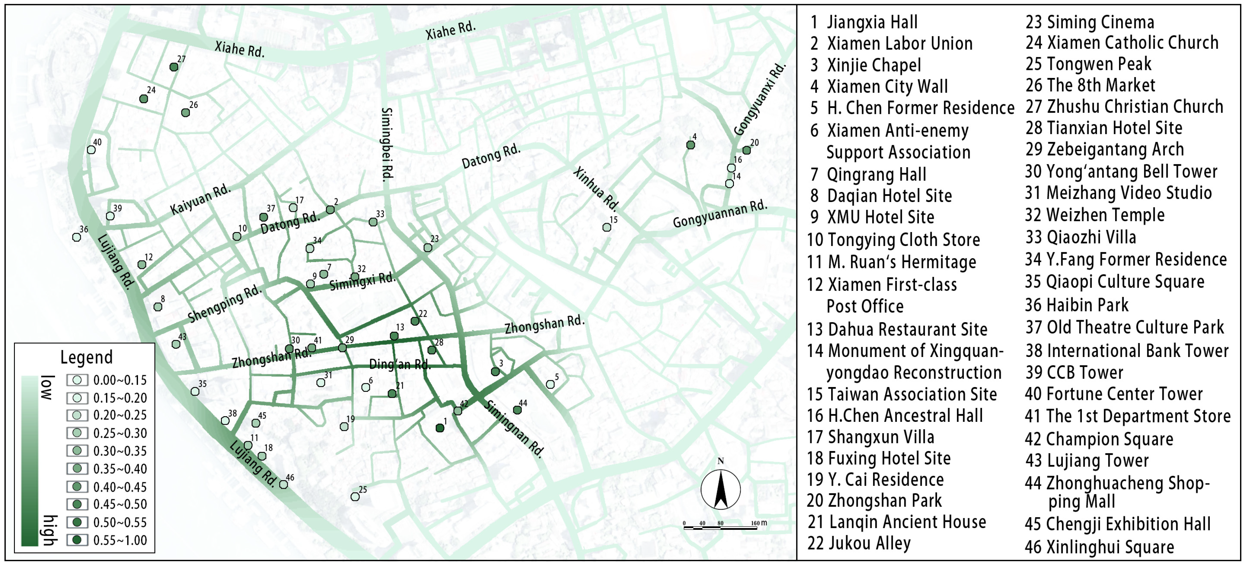
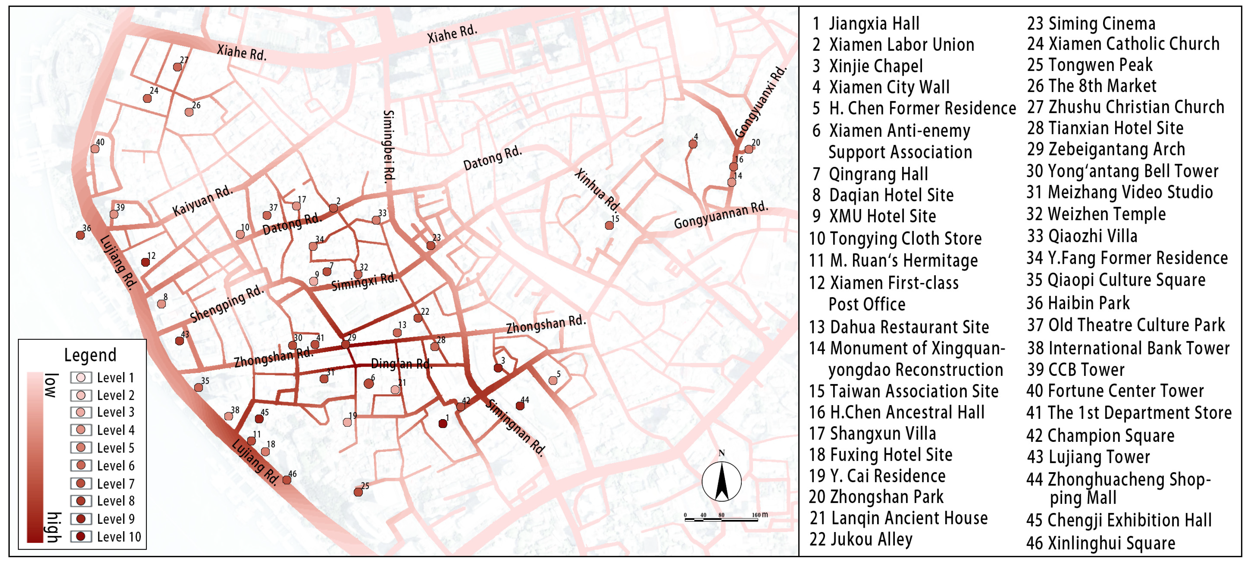
This paper examined the Zhongshan Road Historical and Cultural Block in Xiamen, China. It constructed the evaluation index systems for cultural resource value and the street walking environment through literature analysis and public interviews. This study employed ArcMap 10.8 to perform nuclear density analysis based on these evaluation results. Following the coupling coordination results, this study delineated the preliminary cultural visiting routes, which are subsequently refined according to the findings on cultural resource value. After integrating all proposed routes, a cohesive set of cultural visiting routes for the Zhongshan Road Historical and Cultural Block was established. Finally, the paper proposed targeted optimization strategies for varying levels of cultural visiting routes. This study revealed that cultural resource value and the street walking environment are key factors influencing cultural visiting routes, warranting attention and improvement in planning processes. The construction method for cultural visiting routes, based on the degree of coupling coordination, can serve as a valuable reference for implementing these routes on a block scale.
This paper presents the following distinctions compared to other cultural routes research efforts: (1) The study adopts a specific block-scale perspective rather than a broader regional or city scale, detailing the methods and steps involved in route construction. (2) Unlike other similar studies, this paper shifts focus from examining a single system, such as cultural resource value or the street walking environment, to analyzing the coupling and coordination between these systems. This approach can leverage the combined benefits of the two systems as a foundation for route construction. (3) The research introduces the coupled coordination degree model, which has traditionally been utilized in physics, into the realm of urban culture. It proposes a revised and redefined model that is applicable to cultural visiting routes, thereby offering a valuable reference for the application of this model in urban cultural preservation efforts.
While this study offers valuable insights, it also presents certain limitations that create opportunities for future research. The study primarily relies on static data to evaluate cultural resource value and the street walking environment, which overlook potential changes over time. As a result, it can only present the outcomes of route construction for a specific period. Future research should consider integrating real-time data collection with big data platforms to explore methodologies for constructing cultural visit routes based on dynamic assessments and simulations. Additionally, this paper proposes a method for applying the coupling coordination degree model to the construction of block-scale cultural visiting routes. Further research is warranted to promote the application and modification of this model across different scales and regions. Moreover, the adaptation of the coupling coordination model in this paper primarily relies on the redefinition of each term within the formula. Future research can be enhanced through more innovative alterations to this model. Finally, the strategy section of this study predominantly focuses on planning strategies. Future research should not only emphasize the exploration of cultural resource value and the optimization of the street walking environment but also delve deeper into aspects such as management and operation, as well as public participation.

Author Contributions

Conceptualization, Y.C. and Q.W.; methodology, Y.C. and Q.W.; software, Y.C. and M.Z.; validation, Y.C. and Q.W.; formal analysis, Y.C. and M.Z.; investigation, Y.C., Q.W. and M.Z.; resources, M.Z. and Q.W.; data curation, Q.W.; writing—original draft preparation, Y.C., Q.W. and M.Z.; writing—review and editing, Y.C. and Q.W.; visualization, Y.C. and M.Z.; supervision, Q.W.; project administration, Q.W. and M.Z.; funding acquisition, M.Z. and Q.W. All authors have read and agreed to the published version of the manuscript.

Funding

This research was supported by the Natural Science Research Project of Anhui Educational Committee, China (No. 2023AH040038), the National Natural Science Foundation of China (No. 52408045), and the Fujian Provincial Social Science Foundation of China (No. FJ2024C117).

Data Availability Statement

The original contributions presented in this study are included in the article. Further inquiries can be directed to the corresponding author.

Conflicts of Interest

The authors declare no conflicts of interest.

Appendix A

Table A1. Results of cultural resource value assessment.
SiteResource TypeResultRanking
Chengji Exhibition HallModern urban landscape0.97311
Xiamen First-class Post OfficeHistorical and cultural resource0.91272
Jiangxia HallHistorical and cultural resource0.89703
Zhonghuacheng Shopping MallModern urban landscape0.80204
Tongwen PeakHistorical and cultural resource0.79505
Xinjie ChapelHistorical and cultural resource0.75986
Zhushu Christian ChurchHistorical and cultural resource0.73247
Lanqin Ancient HouseHistorical and cultural resource0.72218
Haibin ParkModern urban landscape0.70329
Xiamen Catholic ChurchHistorical and cultural resource0.694910
Meizhang Video StudioHistorical and cultural resource0.686911
Xiamen City WallHistorical and cultural resource0.658512
Zebeigantang ArchHistorical and cultural resource0.651313
Zhongshan ParkHistorical and cultural resource0.632714
Siming CinemaHistorical and cultural resource0.632715
Old Theatre Culture ParkModern urban landscape0.603916
Xinlinghui SquareModern urban landscape0.603917
Lujiang TowerModern urban landscape0.598018
Xiamen Anti-enemy Support AssociationHistorical and cultural resource0.568219
Xiamen Labor UnionHistorical and cultural resource0.551120
Weizhen TempleHistorical and cultural resource0.536021
The 8th MarketHistorical and cultural resource0.530622
H.Chen Ancestral HallHistorical and cultural resource0.504123
M.Ruan’s HermitageHistorical and cultural resource0.493724
Qiaozhi VillaHistorical and cultural resource0.485325
Qingrang HallHistorical and cultural resource0.401626
Qiaopi Culture SquareModern urban landscape0.400127
Champion SquareModern urban landscape0.400028
Taiwan Association SiteHistorical and cultural resource0.399829
Yong’antang Bell TowerHistorical and cultural resource0.357430
Shangxun VillaHistorical and cultural resource0.299531
Y.Cai ResidenceHistorical and cultural resource0.272132
The 1st Department StoreModern urban landscape0.264133
Jukou AlleyHistorical and cultural resource0.256434
H.Chen Former ResidenceHistorical and cultural resource0.168935
Fuxing Hotel SiteHistorical and cultural resource0.159536
Y.Fang Former ResidenceHistorical and cultural resource0.155937
Dahua Restaurant SiteHistorical and cultural resource0.155038
Tianxian Hotel SiteHistorical and cultural resource0.147939
Monument of Xingquanyongdao Reconstruction Historical and cultural resource0.137040
International Bank TowerModern urban landscape0.135941
CCB TowerModern urban landscape0.135942
Fortune Center TowerModern urban landscape0.135943
Daqian Hotel SiteHistorical and cultural resource0.088944
Tongying Cloth StoreHistorical and cultural resource0.088945
XMU Hotel SiteHistorical and cultural resource0.066946
Table A2. Results of street environment evaluation.
SiteResource TypeResultRanking
Jiangxia HallHistorical and cultural resource0.59891
Tianxian Hotel SiteHistorical and cultural resource0.49332
Jukou AlleyHistorical and cultural resource0.49013
Dahua Restaurant SiteHistorical and cultural resource0.47844
Zhonghuacheng Shopping MallModern urban landscape0.45875
Xinjie ChapelHistorical and cultural resource0.45456
Yong’antang Bell TowerHistorical and cultural resource0.42607
The 1st Department StoreModern urban landscape0.39648
Zebeigantang ArchHistorical and cultural resource0.39519
Qingrang HallHistorical and cultural resource0.338010
Champion SquareModern urban landscape0.333011
Xiamen First-class Post OfficeHistorical and cultural resource0.307712
Daqian Hotel SiteHistorical and cultural resource0.291913
Lujiang TowerModern urban landscape0.291414
Tongying Cloth StoreHistorical and cultural resource0.291315
Fuxing Hotel SiteHistorical and cultural resource0.289816
XMU Hotel SiteHistorical and cultural resource0.288517
Chengji Exhibition HallModern urban landscape0.275018
M.Ruan’s HermitageHistorical and cultural resource0.270019
Siming CinemaHistorical and cultural resource0.261220
Y.Fang Former ResidenceHistorical and cultural resource0.241921
Xinlinghui SquareModern urban landscape0.212422
Taiwan Association SiteHistorical and cultural resource0.200123
H.Chen Ancestral HallHistorical and cultural resource0.185024
Xiamen Anti-enemy Support AssociationHistorical and cultural resource0.183725
Qiaopi Culture SquareModern urban landscape0.173326
Meizhang Video StudioHistorical and cultural resource0.170427
Fortune Center TowerModern urban landscape0.166128
CCB TowerModern urban landscape0.162429
International Bank TowerModern urban landscape0.157630
Tongwen PeakHistorical and cultural resource0.154131
Haibin ParkModern urban landscape0.153932
Old Theatre Culture ParkModern urban landscape0.137733
Zhushu Christian ChurchHistorical and cultural resource0.133534
Weizhen TempleHistorical and cultural resource0.128235
Monument of Xingquanyongdao Reconstruction Historical and cultural resource0.128136
Xiamen Catholic ChurchHistorical and cultural resource0.125837
Xiamen City WallHistorical and cultural resource0.118138
H.Chen Former ResidenceHistorical and cultural resource0.116839
The 8th MarketHistorical and cultural resource0.113440
Xiamen Labor UnionHistorical and cultural resource0.107641
Qiaozhi VillaHistorical and cultural resource0.094542
Zhongshan ParkHistorical and cultural resource0.092543
Shangxun VillaHistorical and cultural resource0.057944
Y.Cai ResidenceHistorical and cultural resource0.054645
Lanqin Ancient HouseHistorical and cultural resource0.042646
Table A3. Coupling coordination degree of “Cultural Resources-Street Environment”.
SiteCoupling Degree (C)Coordination Index (T)Coupling Coordination (D)Result LevelCoupling Coordination Degree
Jiangxia Hall0.99830.93590.966610High quality-coordination
Xiamen Labor Union0.79000.32150.50396Barely-coordination
Xinjie Chapel0.99990.73670.85839Good-coordination
Xiamen City Wall0.77600.38720.54816Barely-coordination
H.Chen Former Residence0.99580.12890.35834Slight-dissonance
Xiamen Anti-enemy Support Association0.93690.39750.61037Primary-coordination
Qingrang Hall0.98190.44600.66187Primary-coordination
Daqian Hotel Site0.50580.24110.34924Slight-dissonance
XMU Hotel Site0.29380.22660.25803Moderate-dissonance
Tongying Cloth Store0.50630.24060.34904Slight-dissonance
M.Ruan’s Hermitage0.99850.43440.65867Primary-coordination
Xiamen First-class Post Office0.95190.68760.80919Good-coordination
Dahua Restaurant Site0.64170.44010.53146Barely-coordination
Monument of Xingquanyongdao Reconstruction0.94910.12210.34044Slight-dissonance
Taiwan Association Site0.99370.32350.56706Barely-coordination
H.Chen Ancestral Hall0.95840.36500.59146Barely-coordination
Shangxun Villa0.66570.14560.31144Slight-dissonance
Fuxing Hotel Site0.79100.27640.46765Forced-dissonance
Y.Cai Residence0.65300.12830.28953Moderate-dissonance
Zhongshan Park0.69280.35110.49325Forced-dissonance
Lanqin Ancient House0.23600.35410.28913Moderate-dissonance
Jukou Alley0.81110.50370.63927Primary-coordination
Siming Cinema0.97780.49970.69907Primary-coordination
Xiamen Catholic Church0.78390.41310.56906Barely-coordination
Tongwen Peak0.81510.49050.63237Primary-coordination
The 8th Market0.81920.31590.50876Barely-coordination
Zhushu Christian Church0.79020.43960.58946Barely-coordination
Tianxian Hotel Site0.61500.44950.52586Barely-coordination
Zebeigantang Arch1.00000.62740.79218Moderate-coordination
Yong’antang Bell Tower0.92900.50030.68177Primary-coordination
Meizhang Video Studio0.87970.44810.62797Primary-coordination
Weizhen Temple0.85690.33170.53316Barely-coordination
Qiaozhi Villa0.77500.27540.46205Forced-dissonance
Y.Fang Former Residence0.83220.23230.43975Forced-dissonance
Qiaopi Culture Square0.97990.30010.54226Barely-coordination
Haibin Park0.84660.44050.61067Primary-coordination
Old Theatre Culture Park0.84950.37580.56506Barely-coordination
International Bank Tower0.89770.14760.36404Slight-dissonance
CCB Tower0.89000.15170.36754Slight-dissonance
Fortune Center Tower0.88400.15500.37024Slight-dissonance
The 1st Department Store0.87210.42520.60897Primary-coordination
Champion Square0.98300.44070.65827Primary-coordination
Lujiang Tower0.99300.50800.71038Moderate-coordination
Zhonghuacheng Shopping Mall0.99970.76250.87319Good-coordination
Chengji Exhibition Hall0.91440.70470.80279Good-coordination
Xinlinghui Square0.95400.44160.64917Primary-coordination

References

  1. Zhu, H. Research on Interpretation and Presentation of Historical and Cultural Blocks: Case on Quzhou Historical and Cultural Block. Master’s Thesis, Beijing University of Civil Engineering and Architecture, Beijing, China, 2022. [Google Scholar]
  2. Li, X.P.; Li, J.S.; Hou, W. Research on Regional Historical Heritage Network from the Perspective of Cultural Landscape: Take the Jinzhong Basin as an Example. Urban Dev. Res. 2020, 27, 101–108. [Google Scholar]
  3. Bian, L.C.; Yu, T. “New-Regeneration” of Historic Districts in Beijing by Regenerating “historical and Cultural Tourist Routes”. In Proceedings of the Diversity and Inclusion—2012 China Urban Planning Annual Conference, Kunming, China, 17–19 October 2012. [Google Scholar]
  4. Moreno, C.; Allam, Z.; Chabaud, D.; Gall, C.; Pratlong, F. Introducing the “15-Minute City”: Sustainability, Resilience and Place Identity in Future Post-Pandemic Cities. Smart Cities 2021, 4, 93–111. [Google Scholar] [CrossRef]
  5. Li, H.P.; Xiao, W.B.; Xiao, J.; Li, C.C.; Lin, T. Historical and Cultural Spatial Network: Connotation Characteristics Construction Methods and Overall Protection Strategies: Based on the Case of Chongqing Historic District at the Confluence of Two Rivers. Urban Dev. Res. 2024, 31, 126–133. [Google Scholar]
  6. Wang, F.; Hu, W.Y.; Gao, C.G. The Coupling and Evolution of Water and Land Transportation Network and Urban Settlements along the Grand Canal from the Perspective of Resilience. Landsc. Archit. 2021, 28, 31–38. [Google Scholar]
  7. Liu, W.; Zhang, J. Evaluation of Rural Tourism Development Effect and Choice of Development Path Along Linear Cultural Heritage Reserve: Taking the Great Wall Cultural Presentation Belt in Beijing as an Example. Urban Dev. Res. 2022, 29, 116–124. [Google Scholar]
  8. Zhang, S.Y.; Liu, J.M.; Pei, T.; Chan, C.S.; Wang, M.D.; Meng, B. Tourism value assessment of linear cultural heritage: The case of the Beijing-Hangzhou Grand Canal in China. Curr. Issues Tour. 2023, 26, 47–69. [Google Scholar] [CrossRef]
  9. Li, H.; Duan, Q.C.; Zeng, Z.J.; Tan, X.L.; Li, G.Y. Value Evaluation and Analysis of Space Characteristics on Linear Cultural Heritage Corridor Ancient Puer Tea Horse Road. In Proceedings of the Geo-Informatics in Resource Management and Sustainable Ecosystem, Hongkong, China, 18–20 November 2016. [Google Scholar]
  10. He, D.; Chen, W.T.; Zhang, J. Integrating Heritage and Environment: Characterization of Cultural Landscape in Beijing Great Wall Heritage Area. Land 2024, 13, 536. [Google Scholar] [CrossRef]
  11. Liu, Y.T.; Li, F.Z.; Li, X. The Path and Strategy of the Revival of Old City in the View of Cultural Routes-Taking Lingchuan County of Shanxi Province as an Example. Chin. Landsc. Archit. 2021, 37, 71–76. [Google Scholar]
  12. Allam, Z.; Chabaud, D.; Gall, C.; Pratlong, F.; Moreno, C. Resilient and Sustainable Cities Research, Policy and Practice; Elsevier: Amsterdam, The Netherlands, 2022. [Google Scholar]
  13. Allam, Z.; Cheshmehzangi, A.; Jones, D. Climate and Social Justice: The Political Economy of Urban Resilience and Mercantilism; Springer: Singapore, 2023. [Google Scholar]
  14. Dai, J.C.; Liu, F.Y. Research on the Construction of Linear Cultural Heritage Value Evaluation Model: A Case Study of the Grand Canal of China. China Anc. City 2023, 37, 90–96. [Google Scholar]
  15. Liu, W.; Cao, T. Research on Cultural Routes Evaluation Model Based on Systematic Cooperation: A Case Study of the Old Road Between Nanyang and Xiangyang. Mod. Urban Res. 2018, 9, 16–24. [Google Scholar]
  16. Locke, R.; Mehaffy, M.; Haas, T.; Olsson, K. Urban Heritage as a Generator of Landscapes: Building New Geographies from Post-Urban Decline in Detroit. Urban Sci. 2018, 2, 92. [Google Scholar] [CrossRef]
  17. Allam, Z.; Bibri, S.; Chabaud, D.; Moreno, C. The Theoretical, Practical, and Technological Foundations of the 15-Minute City Model: Proximity and Its Environmental, Social and Economic Benefits for Sustainability. Energies 2022, 15, 6042. [Google Scholar] [CrossRef]
  18. Allam, Z.; Nieuwenhuijsen, M.; Chabaud, D.; Moreno, C. The 15-minute city offers a new framework for sustainability, liveability, and health. Lancet Planet. Health 2022, 6, E181–E183. [Google Scholar] [CrossRef] [PubMed]
  19. Mehaffy, M.W. UN-Sustainable Urbanism: The Challenge of “Lock-In”. Sustain. Sci. 2024, 16, 7301. [Google Scholar] [CrossRef]
  20. Allam, Z.; Khavarian-Garmsir, A.R.; Lassaube, U.; Chabaud, D.; Moreno, C. Mapping the Implementation Practices of the 15-Minute City. Smart Cities 2024, 7, 2094–2109. [Google Scholar] [CrossRef]
  21. Buras, N. The Art of Classic Planning; Belknap Press: Cambridge, UK, 2020. [Google Scholar]
  22. Ellis, C. The New Urbanism: Critiques and Rebuttals. J. Urban Des. 2002, 7, 261–291. [Google Scholar] [CrossRef]
  23. Locke, R.; Elmlund, P.; Mehaffy, M. Evaluating Landscape Urbanism: Evidence from Lafayette Park, Detroit. J. Urban 2018, 12, 34–59. [Google Scholar] [CrossRef]
  24. Alexander, C. A Pattern Language: Towns, Buildings, Construction; Oxford University Press: New York, NY, USA, 1977. [Google Scholar]
  25. Alexander, C. The Nature of Order, Book 3: A Vision of a Living World; Routledge: London, UK, 2005. [Google Scholar]
  26. Mehaffy, M.; Kryazheva, Y.; Rudd, A.; Salingaros, N. A New Pattern Language for Growing Regions: Places, Networks, Processes; Sustasis Press: Portland, OR, USA, 2020. [Google Scholar]
  27. Mehaffy, M.; Salingaros, N.; Lavdas, A.A. The Modern Campus Fails as Pedestrian Space. Sustain. Sci. 2023, 15, 16427. [Google Scholar] [CrossRef]
  28. Zhou, M.R.; Wei, H.B.; Bian, L.C. Research on Evaluation of Walking Environment on Streets: A Case Study of Shichahai Historic Scenic Area. Shanghai Urban Plan. Rev. 2021, 3, 74–80. [Google Scholar] [CrossRef]
  29. Singh, R. Factors affecting walkability of neighborhoods. In Proceedings of the Urban Planning and Architectural Design for Sustainable Development, Florence, Italy, 14–16 October 2016. [Google Scholar]
  30. Zhou, L.; Li, Y.X.; Cheng, J.L.; Qin, Y.; Shen, G.Q.; Li, B.; Yang, H.J.; Li, S.H. Understanding the aesthetic perceptions and image impressions experienced by tourists walking along tourism trails through continuous cityscapes in Macau. J. Transp. Geogr. 2023, 112, 103703. [Google Scholar] [CrossRef]
  31. Garau, C.; Annunziata, A.; Yamu, C. A walkability assessment tool coupling multi-criteria analysis and space syntax: The case study of Iglesias, Italy. Eur. Plan. Stud. 2024, 32, 211–233. [Google Scholar] [CrossRef]
  32. Caamaño-Franco, I.; Suárez, M.A. The Value Assessment and Planning of Industrial Mining Heritage as a Tourism Attraction: The Case of Las Medulas Cultural Space. Land. 2020, 9, 404. [Google Scholar] [CrossRef]
  33. Li, J.J.; Wang, J.; Li, X. Heritage Value Assessment and Landscape Preservation of Traditional Chinese Villages Based on the Daily Lives of Local Residents: A Study of Tangfang Village in China and the UNESCO HUL Approach. Land 2024, 13, 1535. [Google Scholar] [CrossRef]
  34. Sonta, A.; Jiang, X.F. Rethinking walkability: Exploring the relationship between urban form and neighborhood social cohesion. Sustain. Cities Soc. 2023, 99, 104903. [Google Scholar] [CrossRef]
  35. Kovacs-Gyori, A.; Ristea, A.; Havas, C.; Mehaffy, M.; Hochmair, H.; Resch, B.; Juhász, L.; Lehner, A.; Ramasubramanian, L.; Blaschke, T. Opportunities and Challenges of Geospatial Analysis for Promoting Urban Livability in the Era of Big Data and Machine Learning. ISPRS Int. J. Geoinf. 2020, 9, 752. [Google Scholar] [CrossRef]
  36. Torabi, Z.-A.; Shalbafian, A.; Allam, Z.; Ghaderi, Z.; Murgante, B.; Amir, R.; Khavarian-Garmsir, A.R. Enhancing Memorable Experiences, Tourist Satisfaction, and Revisit Intention through Smart Tourism Technologies. Sustain. Sci. 2022, 14, 2721. [Google Scholar] [CrossRef]
  37. Que, W.M.; Song, T.Y. Heritage Values of Jingxi Trail and Suggestions for Conservation Planning. Chin. Landsc. Archit. 2012, 28, 84–88. [Google Scholar]
  38. Gu, J.X.; Zeng, S.Z.; Chen, W.D.; Balezentis, T.; Sapolaite, V. Tracking Sustainable Development from the Dual Perspective of Environmental and Economic Performance: A Dynamic Framework and Coupling Coordination Degree. Sustain. Dev. 2024, 32, 2962–2975. [Google Scholar] [CrossRef]
  39. He, S.; Luo, D.J.; Guo, K. Analysis of Factors Affecting the Coordinated Development of Urbanization and the Ecological Resource Environment in Southwest China Based on Data Mining. J. Urban. Plan. Dev. 2021, 147, 04021034. [Google Scholar] [CrossRef]
  40. Song, M.L.; Tao, W.L. Coupling and Coordination Analysis of China’s Regional Urban-Rural Integration and Land-Use Efficiency. Growth Change 2022, 53, 1384–1413. [Google Scholar] [CrossRef]
  41. An, Q.L. Evaluation and Strategy of Urban Industrial Heritage Tourism Development Along Heilongjiang Section of Chinese Eastern Railway. Master’s Thesis, Harbin Institute of Technology, Harbin, China, 2021. [Google Scholar]
  42. Ma, N. Research on City Livability Evaluation Based on PCA—Entropy Method Model: Take Chongqing as an Example. Master’s Thesis, Chongqing University, Chongqing, China, 2021. [Google Scholar]
  43. Zhang, T.; Li, L. Research on temporal and spatial variations in the degree of coupling coordination of tourism-urbanization-ecological environment: A case study of Heilongjiang, China. Environ. Dev. Sustain. 2021, 23, 8474–8491. [Google Scholar] [CrossRef]
Figure 1. Excavation of cultural resources in the Zhongshan Road Historical and Cultural Block, Xiamen, China.
Buildings 14 04069 g001
Figure 2. Method of cultural visiting route construction in historical and cultural blocks.
Buildings 14 04069 g002
Figure 3. The evaluation scope of the street walking environment.
Buildings 14 04069 g003
Figure 4. Nuclear density analysis of cultural resource value assessment in Zhongshan Road Historical and Cultural Block, Xiamen, China.
Buildings 14 04069 g004
Figure 5. Nuclear density analysis of the street walking environment evaluation in Zhongshan Road Historical and Cultural Block, Xiamen, China.
Buildings 14 04069 g005
Figure 6. Nuclear density analysis of “cultural resource value-street walking environment” coupling coordination in Zhongshan Road Historical and Cultural Block, Xiamen, China.
Buildings 14 04069 g006
Figure 7. Cultural visiting routes of Zhongshan Road Historical and Cultural Block, Xiamen, China.
Buildings 14 04069 g007
Table 1. Assessment index system of cultural resource value.
Evaluation LayerIndex LayerIndicator Interpretation
Historical and Cultural ValueStacking PropertyValue of heritage accumulated continuously in different periods
AuthenticityAuthentic preservation and presentation of historical relics
WholenessHarmonization in the overall landscape of the whole area
UniquenessCoincidence degree of relic types at the regional scale
Remaining Material ValueBuilding AgeExtent of time since construction of historic buildings
Preservation DegreeOverall preservation of historic buildings and other elements
Decoration DegreeDegree of refinement of details such as decoration and paint
Touristic ValueCultural RepresentationNumber of types of local culture reflected
Tourist ExperienceOpenness and visiting experience
Conservation PlanningUpper PlanningIf there is an upper planning and implementation status
Management RegulationIf there is a management regulation and implementation status
Table 3. Evaluation index system of the street walking environment in Zhongshan Road Historical and Cultural Block, Xiamen, China.
Evaluation LayerIndex LayerData AcquisitionCalculation Formula
SecurityPedestrian encroachment proportionField statisticsThe number of vehicles encroaching on the walkway/Street length
Walking street widthField measurementAverage width of walking street
ComfortStreet cleanlinessField measurementThe area of clutter of the street/Walking street area
Sky sight rateStreet view imageNumber of sky pixels/Number of total pixels
Green sight rateStreet view imageNumber of green pixels/Number of total pixels
Leisure facilities proportionField statisticsNumber of leisure facilities/Street length
ConvenienceDistance from public transport stopsMap measurementDistance from site entrance to the nearest public transport stop
Coherence of guidance systemField statisticsNumber of guide marks/Street length
FunctionalityPOI densityAmap (https://lbs.amap.com/; accessed on 5 January 2024)Number of POI/Street length
POI mixing degreeAmap (https://lbs.amap.com/; accessed on 5 January 2024)Number of POI types/Street length
ContinuityStreet width change rateField measurement(Max street width-Min street width)/Average Width of street
Building alignment rateField measurementWall length/Street length
Depth–width ratioField measurementAverage building height/Average width of street
Cultural landscape interface ratioField measurementCultural landscape interface length/Street length
Table 4. Standard for classification of coupling coordination degree.
Range of D ValuesResult LevelCoupling Coordination Degree
[0.0~0.1)1Extreme-dissonance
[0.1~0.2)2Serious-dissonance
[0.2~0.3)3Moderate-dissonance
[0.3~0.4)4Slight-dissonance
[0.4~0.5)5Forced-dissonance
[0.5~0.6)6Barely-coordination
[0.6~0.7)7Primary-coordination
[0.7~0.8)8Moderate-coordination
[0.8~0.9)9Good-coordination
[0.9~1.0]10High quality-coordination
Table 2. The scoring basis of cultural resource value assessment in Zhongshan Road Historical and Cultural Block, Xiamen, China.
Index LayerLevel 1 (10 Points)Level 2 (7 Points)Level 3 (4 Points)Level 4 (0 Points)
Stacking PropertyReflects 3 periods and aboveReflects 2 periodsReflects several ages of a periodReflects an age
AuthenticityPresent integrityPresent goodPresent mediumPresent poor
WholenessGood coordinationBasic coordinationInconsistentBad coordination
UniquenessHas only 1 remnant of this type on Xiamen islandHas only 1 remnant of this type in the blockHas less than 4 remnants of this type in the blockHas more than 3 remnants of this type in the block
Building AgeBefore 19121912–19491949–1978After 1978
Preservation DegreeRetains more than 75%Retains 50–75%Retains 25–50%Retains less than 25%
Decoration DegreeNumerous and exquisiteNumerous or exquisiteA few or normalBasically no
Cultural RepresentationReflects more than 3 culture typesReflects 2 culture typesReflects 1 culture typesNot clearly related to the local culture
Tourist ExperienceOpen and experience perfectOpen and experience wellOpen but experience mediumNot open
Upper PlanningHas and strictly implementedHas and partially implementedHas but not yet implementedDoes not have
Management RegulationHas and strictly implementedHas and partially implementedHas but not yet implementedDoes not have
Disclaimer/Publisher’s Note: The statements, opinions and data contained in all publications are solely those of the individual author(s) and contributor(s) and not of MDPI and/or the editor(s). MDPI and/or the editor(s) disclaim responsibility for any injury to people or property resulting from any ideas, methods, instructions or products referred to in the content.

