1. Introduction
Cultural heritage is defined as an expression of lifestyles that are inherited from the past generations, including traditions, practices, places, objects, artistic works, structures and other values developed by any community [
1]. Cultural heritage can be classified as follows:
Built environment (buildings, city scenes, archaeological remains).
Natural environment (rural landscapes, beaches and shorelines, agricultural heritage).
Other works (books and documents, objects, pictures) [
2].
Historical monumental buildings built in different periods by following different faiths are also evaluated within this scope. At the same time, such structures appear as an indicator of societies’ belief types, engineering backgrounds, understanding of art and economic status [
3,
4,
5,
6,
7]. Such structures are invaluable cultural assets that strongly connect the past and the future [
8,
9]. Minarets, which have an important meaning in Islamic belief, are high, slender and elegant structures built in the form of towers in which the call to prayer is read. The behavior of such structures under the influence of horizontal loads has a special importance due to their structural features. While minarets used to be built with local stones and materials, they can also be built using different types of materials such as concrete, reinforced concrete and steel, depending on the developments in building technologies today. In general, the pulpit, transition segment, web (body), balcony, upper part of web, spire and end ornaments are the components of minaret structures. The parts of the Bitlis Ulu Mosque minaret, considered in the study, are shown in
Figure 1.
Historical masonry minarets were generally built using local materials and craftsmanship without any engineering service. Even though such minarets have been exposed to many natural disasters over time, they have managed to survive till today. At the same time, such structures provide important information about the architecture, art, construction technologies and lifestyles of that day. Such structures, which are evaluated within the scope of historical and cultural heritage, are invaluable. Each interdisciplinary study to be deployed on such structures has a separate importance. Several studies have been carried out in the field of civil and earthquake engineering related to masonry minarets. Işık and Antep (2018) analyzed the earthquake behavior for the minaret of Kadı Mahmut Mosque in the Ahlat district according to Turkey’s 2007 earthquake code and calculated the resulting stress and displacement values [
10]. Çalık et al. (2012) investigated the static and dynamic behaviors of the masonry minaret of the Merkez Hacı Kasım Muhittin Mosque in Trabzon with analytical and experimental methods in order to determine its structural safety and to restore it [
11]. Suliman et al. (2021) studied the behavior of the minaret of the Carol I Mosque in Constanta, Romania, under seismic loads [
12]. Işık et al. (2022) carried out the structural analyses for the historical Five Minarets, one of the important symbols of Bitlis, according to the Turkish Building Earthquake Code-2018 only. In their studies, only one earthquake ground motion level and the location of the minaret were considered in structural analyzes [
13]. Çoşgun and Türk (2012) investigated the dynamic behavior of a historical masonry minaret in Istanbul and proposed a strengthening method for the minaret [
14]. Erdil et al. (2018) examined the behavior of the Van Ulu Mosque under seismic loads and compared the stress and crack locations for the Van Ulu Mosque, where the amount of damage increased as a result of the 2011 Van earthquakes [
15]. Dogangun et al. (2008) carried out structural analyses for three masonry minarets using the 1999 Kocaeli and Düzce earthquake ground motions data set on the dynamic behavior of unreinforced masonry minarets. Modal analyses of the models showed that the structural periods and the overall structural response were affected by the minaret height and the spectral characteristics of the input motion [
16]. Pekgökgöz et al. (2018) determined the elasticity module of the Şanlıurfa Ulu Mosque’s minaret building stone with ultrasonic tests [
17]. Livaoglu et al. (2018) revealed the effect of the change of geometric properties on the dynamic behavior of seven different masonry minarets in Bursa [
18]. Basaran et al. (2016) conducted structural analyses of the minaret of the Hacı Mahmut mosque using the material properties obtained as a result of nondestructive and destructive tests [
19]. Oliveira et al. (2012) compared the results of vibration tests and numerical modeling in historical minarets with different characteristics [
20]. Hejazi et al. (2016) performed structural analyses for nine historical brick masonry minarets in Isfahan under the effects of weight, temperature, wind and earthquake [
21]. Türkeli (2020) deployed dynamic analyses for the minaret of Iskender Pasha Mosque using the finite element method under the effects of wind and earthquake [
22]. Muvafik (2014) presented the field survey results together with the seismic analyses of the masonry brick minaret of the historical Ulu Mosque, which was damaged in the 23 October (Erciş) and 9 November (Edremit) 2011 Van earthquakes [
23]. Karaşin et al. (2016) stated the damages and solution proposals for the Bitlis Ulu Mosque together with a site survey and structural analyses [
24]. In these studies, besides structural analyses under the influence of earthquake and wind forces, rehabilitation proposals are also presented. These studies can also be considered as case studies on the modeling and strengthening of masonry minarets with the finite element method and determining their seismic behavior using different seismic analysis methods.
While determining the behavior of engineering structures under the influence of earthquakes, seismic design regulations and the seismicity parameters of the geographical locations where the structures built should be considered [
25,
26]. Seismic parameters may vary with different probabilities of exceedance. Within the scope of this study, four different probabilities of exceedance were considered for the selected masonry minaret. While considering the probabilities, four different values included in the Turkish Building Earthquake Code-2018 (TBEC-2018) [
27], with a probability of exceedance in 50 years with 2%, 10%, 50% and 68% were taken into account. These obtained values were compared with the standard earthquake ground motion level in the previous earthquake regulation (TSDC-2007) [
28] in the country.
Developments and innovations in the scientific literature make changes in seismic design regulations inevitable [
29,
30]. Necessary updates and amendments were made to both earthquake regulations and earthquake hazard maps on different dates in Turkey. One of the important parameters that have changed with the current regulation has been the earthquake ground motion levels. While there was only one ground motion level in the previous regulation, there are four different ground motion levels with four different probabilities to be exceeded in the current regulation [
31,
32]. Design spectra obtained on a regional basis in the previous regulations have been replaced by site-specific design spectra for the first time with the current regulation [
33]. In short, the concept of earthquake zone has been completely removed and the concept of earthquake hazard specific to a geographical location has started [
34,
35,
36,
37]. Another variable considered in this study is the effect of different geographical locations on the seismic behavior of masonry minarets. Structural analyses were carried out separately by considering seven different settlements located in the same region in the previous earthquake hazard map whose locations are in seven different geographical regions in Turkey.
The main purpose of the study was to reveal the effects of different earthquake ground motion levels and geographical-site-specific design spectra on a masonry minaret. For this purpose, the historical Ulu Mosque’s minaret in the province of Bitlis (Turkey) was chosen as a case study. Structural analyses were carried out by creating a finite element model of the minaret using the macromodeling technique. First, analyses were carried out using the design spectra obtained for the different exceedance probabilities specified in the current earthquake code for the province of Bitlis, where the minaret is located. In order to make comparisons between the two earthquake codes, analyses were made using the standard design spectrum given for the probability of exceedance in the previous earthquake code. In the next stage of the study, considering the provinces of Çankırı, Aydın, Amasya, Kocaeli, Siirt, Bitlis and Osmaniye, which are in the same earthquake zone in the previous earthquake zone map, structural analyses were carried out for the same ground motion level in the last two earthquake codes and the effect of geographical-site-specific design spectra. At the same time, by using the acceleration records of the 2011 Van earthquake, which is the closest region to Bitlis, where the Ulu Mosque’s minaret is located, analyses were performed in the time history domain and compared with the values predicted in the last two regulations. In addition, seismic parameters and design spectra were obtained for the settlements considered and comparisons were made. By giving detailed information about the Ulu Mosque and its minaret, its current structural status was determined based on site observations. The study aimed at revealing the two important amendments in the current regulation used in Turkey from the response of the selected masonry minaret.
Within the scope of this study, Ulu Mosque’s minaret, which is one of the five historical minarets in Bitlis, was chosen as a sample masonry minaret. This study includes not only the minaret of the Great Mosque, but also a very detailed architectural and structural features of the mosque part. Structural analyzes were carried out taking into account not only the latest earthquake code used in Turkey, but also the previous earthquake code. Thus, it was possible to make a comparison between the last two earthquake codes of masonry structures in Turkey. In addition, comparisons were made with the recent earthquake acceleration values that occurred in the regions close to the minaret’s location and the acceleration values predicted in the last two earthquake hazard maps in Turkey. With this, we tried to reveal whether the earthquake hazard was adequately specified in the structural analysis. Moreover, the novelty of this study was the structural analyzes according to different probabilities of exceedance used for the first time in the current earthquake code. In addition, it is one of the novelties in the study to perform structural analyzes by using the geographical-location-specific design spectra that were used for the first time with the current earthquake code in Turkey, taking into account five different geographical locations in the same earthquake hazard zone in the previous earthquake hazard map. With this, the effect of location-specific design spectra on masonry minarets was revealed. In addition, performance levels were determined based on the detailed analyses deployed.
2. Ulu (Grand) Mosque and Its Minaret
Although Bitlis is located on a strategic transition corridor in the Eastern Anatolia region of Turkey, it has been the cradle of many civilizations. There are many historical and monumental buildings and artifacts belonging to different civilizations in the province. One of the most important of them is the Bitlis Grand Mosque and its minaret. Different images of the Ulu (Grand) Mosque and its minaret are shown in
Figure 2.
Minarets are tall and slender structures in the form of towers, which are generally built adjacent to mosques and in a separate area, in which the call to prayer is made. For the scope of this study, the Ulu Mosque’s minaret, which is located in the province of Bitlis built from unreinforced masonry, was chosen. Different images of the minaret are shown in
Figure 3.
Bitlis Ulu Mosque was built in the Gazibey neighborhood, southeast of Bitlis Castle, on the edge of the Kömüs stream. The building, which forms a complex with a sanctuary in the south, a courtyard with a portico in the middle and a minaret in the northwest outer corner of the courtyard, is thought to have been a place of worship before it was built as a mosque (
Figure 4 and
Figure 5). The typology of the windows and their position on the wall are important data supporting this argument.
There is no definite information about the construction date of the mosque. Şen reports from Ibn-ul Esir in 2018 that it was built in the period of the first Islamic conquests, and it was one of the mosques that was destroyed in the Byzantine period in 928 M [
38]. The mosque appears in the miniature of Bitlis, drawn by Matrakçı Nasuh around 1535. It is pictured with its minaret in the southeast of the inner castle, inside the outer castle walls. The south façade of the mosque is stylized with the protrusion of the sanctuary and the window layout placed on the upper level (
Figure 6) [
39,
40,
41,
42]. The Seljuk period work, which is referred to as Cami-façade Köhne in the Şerefname, also has this mosque.
There are data regarding the construction period of the part of the building used as a place of worship. There are two written inscriptions, which are among the most important of them, in the structure. These are the inscriptions on the right side of the door from the middle of the north façade and above the door at the west entrance. In the inscription to the right of the middle door, there is information that the building was renovated by Ebu’n-Nazr Muhammed bin El-Muzaffer bin Rüstem in 1150. The inscription on the door at the western entrance was translated by Arık (1971) and it is written that it was repaired by Osman Ağa in 1651 [
43]. The building typology and early inscription clearly reveal which period the existing building belongs to. This inscription is an old-dated one, which coincides with the period when Dilmaçoğulları Principality ruled, and the principality was under the influence of the Artuqids. The current state of the sanctuary section also constitutes the first example of the Artuqid period’s cross-planned, domed and symmetrical mosque scheme in front of the mihrab [
43,
44,
45,
46,
47]. The other inscription is related with its repair made during the Serefhans period.
On the exterior part of the rectangular prism-shaped structure, the mihrab protrusion in the direction of the qibla and the conical dome on this section overflow. The mosque, which has an east–west-oriented plan scheme, is divided into three transverse naves in this direction. The spatial part of the structure is supported by five cross-like columns in two horizontal rows. The roofing part of the mihrab is domed. The columns in this section were kept wider and thrusting arches were added to support the dome. There are four windows in the dome. Other sections are covered with east–west-oriented vaults. It is supported by hidden arches and pendentives in the wall joints. The building originally had a flat roof, but a metal hipped roof was added after restoration work. It has been raised 80 cm above the exterior wall to hide the roof. The windows on the three façades of the building are just below the ceiling level. Three windows in the east and west have circular arches, and two windows in the south are rectangular. On the facade where the entrance is located, there are three pointed arched doors in the middle, and two windows between the doors. Due to the sloppy ground level, a gallery was built up to the outer ground level, enclosing the western and southern facades of the building.
The sanctuary and the minaret appear as two separate structures, with approximately 11 m between them. During the restoration works initiated by Bitlis Regional Directorate of Foundations in 2012, traces of a courtyard with a fountain in the middle and the portico around it were unearthed. Yegin (2019) stated that the cruciform column parts were of the same size and typology as those in the mosque, so this part was built at the same time as the mosque [
48,
49]. The upper cover of the reconstructed portico was built with a pointed barrel vault like the one in the sanctuary. In the section where the minaret and the portico section meet, a load-bearing wall was also built.
The minaret, located in the northwest part of the courtyard with a portico, has three entrance gates at different levels. It is written on the inscription on the eastern entrance gate that it was built in the period of Serefhans in 1492/1493 [
43,
49]. There are two more inscriptions on the web of the body. The inscription on the western part of the lower part of the body cannot be read because it was destroyed during the 1916 Russian occupation. The inscription in the middle part of the body cannot be read due to similar reasons and deterioration, albeit slight. Its base consists of a square prism lectern and a cube section from the corners to a chamfered circular body. There are two rectangular gates at the ground level and at the 4 m level on the south face. A wall was built in front of the lower door during the restoration phase. The epitaph on the rectangular door on the upper level in the western part is decorated with an archivolt. There is one crenelated window on the southwest face of the lower part and one on the southeast face of the upper part of the body. There are also bullet marks around these windows. From the body, which does not have an ornamental element, to the balcony, a bracelet is used. Arınç (1991) stated that the cone section of the minaret was destroyed in 1975 because of a lightning strike [
50]. These sections were renovated as a plain honeycomb-octagonal prism cone with a cylindrical body, such as that of the Meydan Minaret and the Şerefiye Külliyesi Minaret (
Figure 7). Within the scope of this study, the appearance and plans of the minaret of the Great Mosque, one of the most important historical structures of Bitlis Province, are shown in
Figure 8.
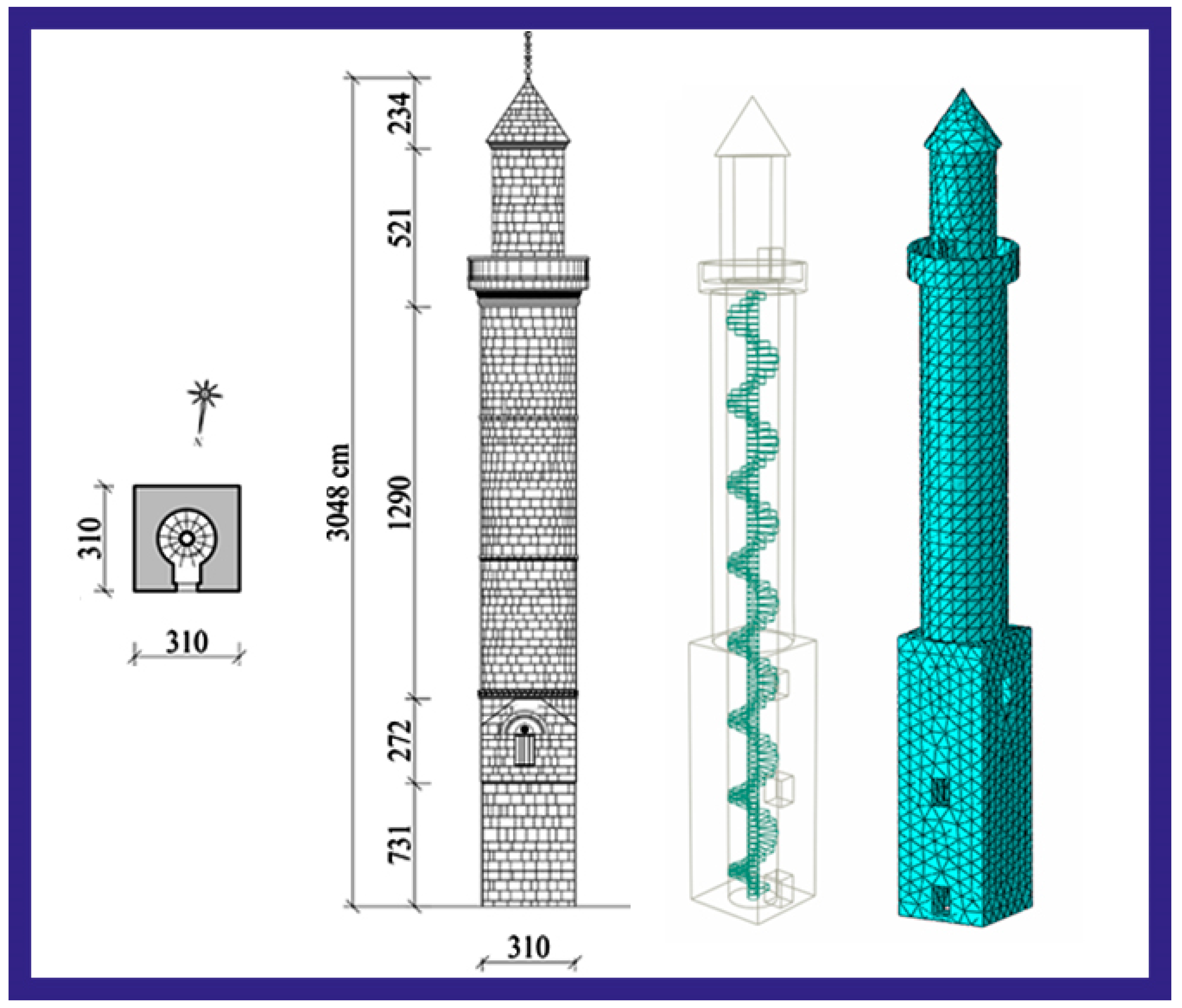
The Ulu Mosque and its minaret were built with a single balcony by local masters and workers, using the Bitlis stone. The dimensions of the Ulu Mosque’s minaret are 3.10 × 3.10 m and it was built on a square foundation. It has a cylindrical body shape and has a body diameter of 3.10 m. The body wall thickness of the minaret is 0.60 m. The total height for this minaret was determined as 30.48 m. These features of the Bitlis Ulu Mosque’s minaret are shown in
Table 1.
3. Observation-Based Analysis on the Great Mosque and Minaret
In this part of the study, the current structural condition of the minaret and the mosque has been evaluated based on site observations. The city center of Bitlis, where the minaret is located, is prone to heavy snowfall in the region [
51]. Day and night temperature differences are quite high in the city center, especially in winter. For these reasons, all the buildings in the province are under a freeze–thaw effect. In addition to the high groundwater level in the city center, natural disasters such as many earthquakes, rock falls, landslides, floods and avalanches are frequently experienced in and around Bitlis. Due to earthquakes and other natural disasters, various types of damage have occurred to the Ulu Mosque and its minaret over time. Moreover, environmental factors have also contributed significantly to these damages. The mosque and minaret were built with the material known locally as Bitlis stone. The minaret and the mosque were constantly monitored by the relevant institutions and organizations over time, and necessary interventions were made in a timely manner. The damages noted by the on-site observations of the mosque and minaret by the authors are shown in
Table 2.
The locations of the damages observed in different parts of the Bitlis Ulu Mosque are shown in
Figure 9.
Due to its location at the lowest elevation of the province, Ulu Mosque is also affected by the high groundwater level. This effect is an important factor causing a moisture problem with minor partial settlements in the structure. It is possible to see this effect in the lower parts of almost all vertical load-bearing elements in the mosque. In addition, calcifications are clearly observed on the exterior walls of the mosque due to rain and snow waters. The mosque has recently been repaired and renovated. Negligible mass losses and wall joint losses occurred on the outer walls of the mosque. There are plant formations in some parts of the dome of the mosque. Precipitation water coming from the canals, which were built to remove rain and snow water on the roof of the mosque, known as coratan in its local name, creates a moisture effect in these parts by making a collision effect on the walls of the exterior part. The fact that the mosque is very close to the Bitlis stream bed causes groundwater to be influential inside the mosque. It can be said that the biggest problem for the mosque today is the underground and precipitation waters. A drainage system surrounding the structure can be suggested to prevent possible damage induced by ground surface water that may cause partial settlements. No cracks or damage were observed on the elements of the mosque load-bearing system. The visuals of the damages observed in different parts of the Bitlis Ulu Mosque are shown in
Figure 10.
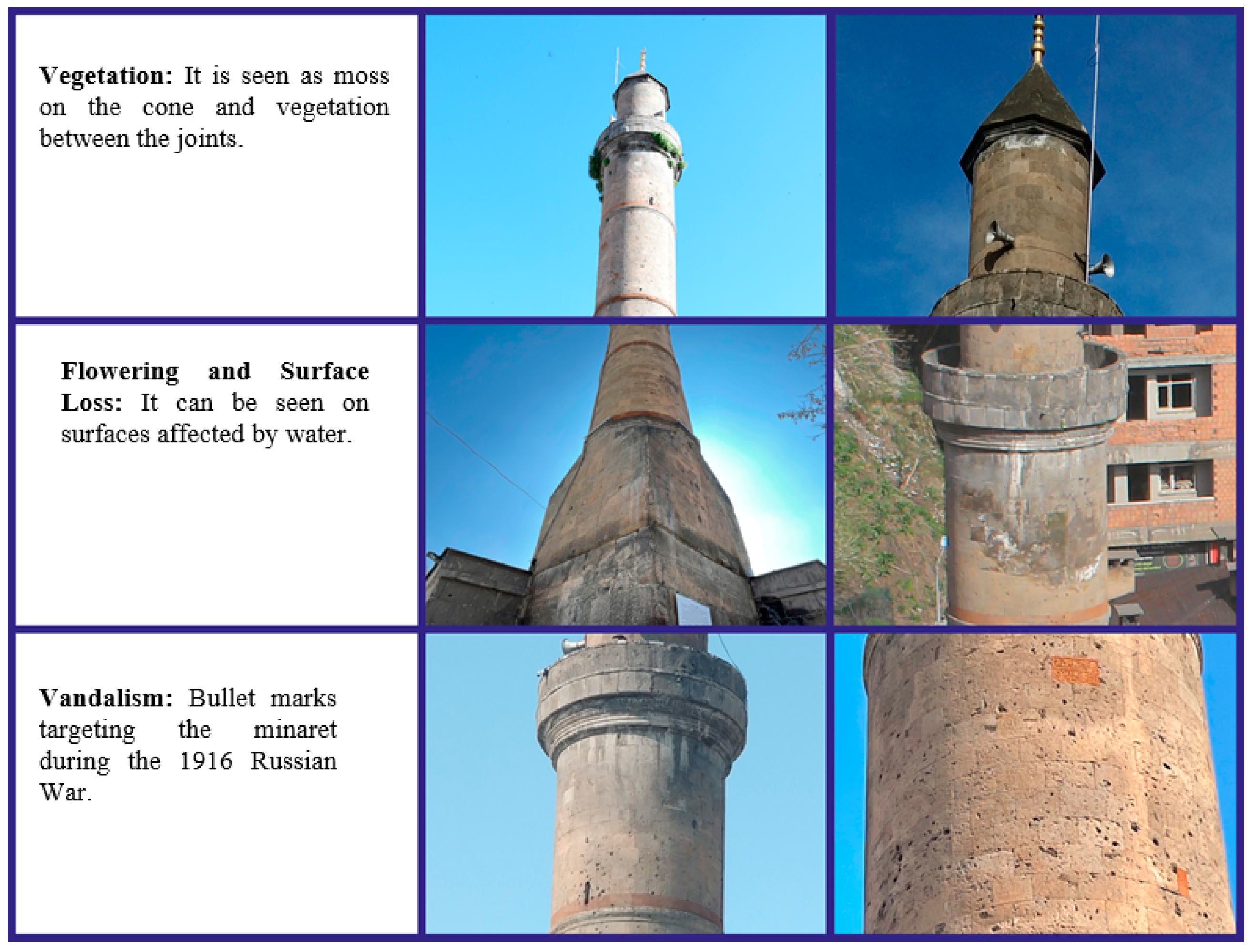
Based on the visual inspections on the Ulu (Grand) Mosque’s minaret, the following damages were observed as shown in
Figure 11.
Recently, the minaret of the Ulu Mosque has also undergone some repairs in order to preserve its originality. It was determined that the most obvious damage observed on the minaret was traces of bullets. There are numerous traces of bullets on the minaret. Calcifications have been observed especially in the balcony part of the minaret due to precipitation. There is mass loss and joint loss in very few parts. There are vegetal formations in places of the cone part. There is a darkening on some stones that form the minaret. The Bitlis Ulu Mosque and its minaret is one of the Five Minarets that are one of the beauties of Bitlis Province. In this respect, the necessary interventions and repairs to the mosque and minaret were made by the relevant institutions and organizations over time. However, it is inevitable that there will be deteriorations and damages due to the characteristics of the Bitlis stone used, subjected to the excessive and long duration of snowfall. It is known that the Bitlis stone, which was used in the construction of the minaret and the mosque, causes erosion and destruction due to its soft spongy feature. This situation is affected by temperature differences, frost and humid environments, causing fragmentation and rupture. The water movement seen at the ground level of the building induced by the ground water and rainwater must be prevented by installing a drainage system. Moisture-induced deterioration is observed in the parts of the stone texture that met water. Installing the necessary water insulation to the areas where water is a problem at points of the building floor would limit the possible future damages.
4. Determination of Seismic Parameters for the Selected Settlements
Earthquake zone and hazard maps were prepared at different dates in Turkey. The last two maps differ from the others in that they were prepared using a probabilistic approach. The map of 1972 was prepared using the deterministic method and was amended in 1996 depending on scientific developments. The 1996 Turkey Earthquake Zones Map was prepared by considering the 10% probability of exceedance within 50 years. In this map, five different earthquake zones were taken into account, with the first degree being the most dangerous. All values on the map were on a regional basis and required the use of the same values in the same earthquake zone. In this map, seismicity parameters specific to each geographical location were not considered. Using the recent developments in earthquake and civil engineering, an up-to-date fault database and earthquake catalogues, the map in 1996 was replaced by the Turkey Earthquake Hazard Map, which was completed in 2018. With the current map, the earthquake hazard on a microscale was considered. The last two earthquake maps used in Turkey considered in this study are shown in
Figure 12 and
Figure 13, respectively. The Turkey Earthquake Hazard Map Interactive Web Earthquake Application (TEHMIWA) [
52] was used in order to obtain the seismic parameters of any location with the help of today’s technology along with the updated map.
Within the scope of this study, in order to reveal the effect of the transition from regional to site-specific earthquake hazards on the seismic behavior of masonry minarets, seven different settlements, each one from seven different geographical regions of Turkey, with the same earthquake zone (1. °) on the previous map were taken into account. The considered settlements are shown in
Figure 14.
Kocaeli (Marmara region), Bitlis (Eastern Anatolia region), Aydın (Aegean region), Siirt (Southeast Anatolia region), Amasya (Black Sea region), Çankırı (Central Anatolia region) and Osmaniye (Mediterranean region) provinces are located in the same earthquake zone. A random geographic location was chosen from each of the centers. For these settlements, earthquake parameters were obtained with the help of TEHMIWA, considering four different ground motion levels with different exceedance probabilities. Different earthquake ground motion levels specified in TBEC-2018 are given in
Table 3 to be considered in this study. In the previous regulation, TSDC-2007, only the standard design ground motion level, which has a 10% probability of being exceeded in 50 years, used to be taken into account.
In order to make a comparative assessment, the local soil class ZB in TBEC-2018 determined in the site survey reports conducted by the relevant public institutions for the location of the Bitlis Great Mosque’s minaret was taken into account. The peak ground acceleration (PGA) and the peak ground velocity (PGV) values obtained for different probability of exceedance for the selected settlements are shown in
Table 4.
Among the selected settlements, the highest PGA and PGV values were obtained for Kocaeli, while the lowest values were obtained for the province of Siirt. The ratio of the highest and lowest PGA values was obtained as 2.48 for DD-1. The comparison of the PGA values and design spectral acceleration coefficients predicted in the last two regulations and the maps according to the DD-2 ground motion level is also presented in
Table 5.
PGA and S
DS values for all settlements considered in this study for the same earthquake zone in the former map were completely represented with different values in the current regulation. However, since the previous regulation and the map were prepared on a regional basis, these two values were assumed to be the same. The fact that each location had its own seismicity parameters indicated that it was more realistic to base the current regulation on a site-specific seismic hazard analysis. While PGA values increased for Aydın, Amasya and Kocaeli within the selected settlements, lower values were obtained for other provinces than the values predicted in the previous regulation. While the biggest increase was observed in Kocaeli, the biggest decrease was in Siirt. This situation remained valid for S
DS as well. Another variable used within the scope of this study was the different probability of exceedance levels. Other seismic parameters considered within the scope of this study are given in
Table 6.
There was no change in the local ground effect coefficients obtained for the different probability of exceedance levels for the province of Bitlis. However, as the probability of exceedance levels increased, the S
S, S
1, S
DS and S
D1 values decreased. This is due to the fact that very rare earthquakes have higher magnitudes. The design spectra, on the other hand, were obtained by fitting a smoothed envelope curve to the response spectra calculated from different ground motion acceleration records in order to take into account the maximum earthquake effects that may occur, by taking into account the seismic characteristics and local site conditions of any region [
54,
55]. The change in the design spectrum curves also affected the displacement demands in the buildings. It is obvious that damage estimations and building performances would deviate from the realistic values in buildings when displacement demands are not met [
56,
57]. A comparison of the obtained horizontal and vertical elastic design spectra is given in
Figure 15.
Since the vertical elastic design spectrum was used for the first time with the current regulation, it was not possible to compare it with the previous regulation. While a single design spectrum was used for the settlements selected in the previous map, a design spectrum specific to each geographical location was used together with the current regulation. A comparison of the obtained horizontal elastic design spectra revealed this difference. The comparison of the horizontal and vertical elastic design spectra obtained by considering the different probabilities of exceedance for the minaret is given in
Figure 16.
The horizontal and vertical elastic design spectra with the largest amplitude for ground motion levels with different recurrence periods were obtained for the largest earthquake with a recurrence period of 2475 years.
Table 7 shows the comparison of the earthquake data that occurred recently around the province of Bitlis, where the minaret is located, and the values obtained for the location of the minaret.
It is seen that the PGA values measured for the Van earthquakes, which are the recent earthquakes that have occurred in and around Bitlis, where the Ulu Mosque is located, are lower than the values predicted by the current regulation. Except for the Bingöl (2003) earthquake, the PGA values measured for all earthquakes were lower than the predictions for DD-1. For DD-2, the values measured for the Bingöl (2003) earthquake as well as the Sivrice (2020) and Erzincan (1992) earthquakes were larger than the predicted one. Bitlis Province is approximately 200 km from Bingöl and 350 km from Erzincan and Sivrice. In addition, the measured value of the 2011 Van earthquake at the earthquake station in Bitlis is known to be 0.104 g. Therefore, the values obtained for the largest earthquake affecting Bitlis recently were considerably lower than the PGA value foreseen in the last two earthquake codes.
5. Structural Analyses
For the analysis and design of today’s modern engineering structures, many computer software packages have been developed that facilitate data transfer and transfer the results to application projects in an integrated manner. The load-bearing systems of masonry buildings differ from today’s modern engineering structures. For this reason, the finite element method is preferred in the structural analysis of such structures. The first step in this method is to create a numerical model of the structure to be examined. Numerical modeling can be defined as the reliable and compatible conversion of structural system elements made of different materials and having a variable cross-section geometry into mathematical terms according to the fundamental principles of mechanics. The finite element analysis of masonry structures is computationally a demanding process [
58,
59].
The realization of the analysis in the created structural model roughly consists of the stages of creating the geometry, mesh production, physical setup, numerical solution and obtaining the results. ABAQUS is software for both the modeling and analysis of mechanical components and the visualization of the finite element analysis result. Preprocessing and postprocessing stages can also be performed with all the components of modeling such as monitoring the solution, intervening in the process and examining the results [
60]. In some cases, simple finite element models can be created by developing some approaches and simplifications regarding the geometric properties of structures. Despite such minor changes, FE models can be used to evaluate the seismic performance of such building typologies [
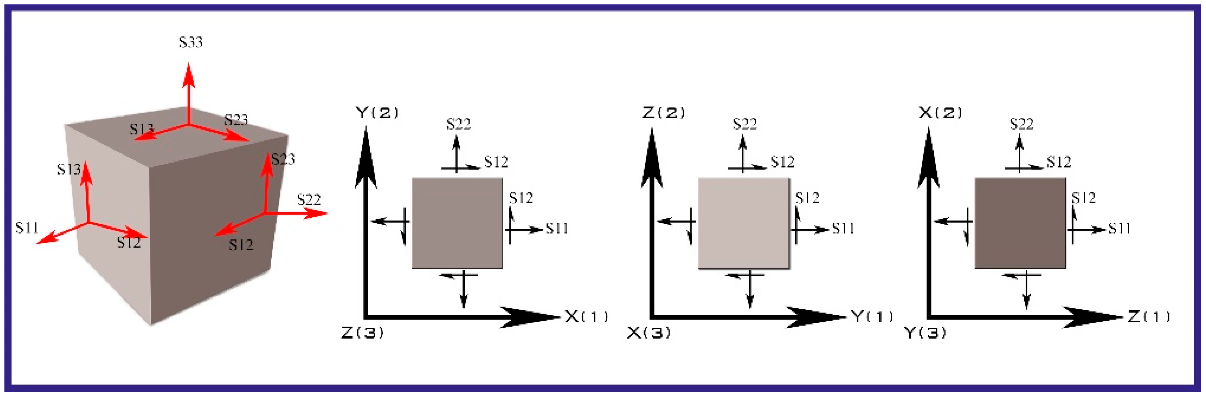
61]. The sign convention and directional assumptions of the elements used in the structural models created using finite elements are shown in
Figure 17, adhering to the assumptions stipulated by the software program (ABAQUS 2022) [
60] in which the numerical modeling was made.
As indicated in
Figure 17: S11: vertical stress in (x) direction, S22: axial stress in (y) direction, S33: axial stress in (z) direction, (S12 = S21): shear stresses in x–y plane. While determining the material properties for the minaret, the following literature works were followed Işık et al. (2020) [
62] and Işık et al. (2022) [
13]. The elastic modulus (E) and unit weight (γ) values of Bitlis stone were taken as a single value in all structures. The properties of the material used are given in
Table 8.
The modeling of masonry walls is extremely important in the evaluation and design of historical and modern masonry structures. Masonry walls can be modeled using three different modeling techniques such as a detailed micro modeling, simplified micro modeling and macro modeling. These models can be seen in
Figure 18.
In this study, a finite element model of the minaret was created using the macro modeling technique. The macro modeling technique is one of the commonly used masonry structural modeling techniques in the literature. The historical masonry bell towers in South-East Lombardy in Italy [
63], historical fortified masonry palaces in Switzerland and Northern Italy [
64], Emir Bayındır Bridge in Turkey [
65], San Pietro and San Benedetto churches in Italy [
66], Torre De la Vela in Spain [
67], Gaskar brick minaret in Iran [
68] and five historical masonry minarets in Antalya (Turkey) [
69] are some of the studies examining the seismic behavior of different types of structures using this type of structural modeling technique. While doing this type of modeling, analyses are carried out without making any distinction between the binding material (mortar, etc.) used in the building and the structural elements. In this modeling, the masonry unit and the properties of the mortar are homogenized and considered as masonry composite material. The mechanical properties of this model are the values obtained as a result of the homogenization process. Macro modeling is more convenient in practice because it requires less computational cost. However, with macro modeling, stress distributions in masonry units and mortar can be obtained accurately [
70,
71,
72]. The Bitlis stone used in the minaret and the mortar that connects them were considered as a single material, and the material properties of the Bitlis stone were taken into account in the analyses for these two materials.
5.1. Structural Analysis Results According to Different Probability of Exceedance Levels
While modeling with the ABAQUS program, stairs were taken into account and drawn together with the outer wall to avoid possible problems in the meshing system and intersection. The macro modelling presupposed that the masonry structure was a homogenous continuum that could be discretized with a finite element mesh that did not replicate the wall texture but rather met the criteria established by the method itself. This modeling approach stroke a balance between accuracy and simplicity by aiming to produce results at a global level and keeping computational work at a manageable level. The minaret was analyzed with FE models consisting of ten-node quadratic tetrahedral elements (C3D10) with four integration points chosen as the mesh type. In order to further improve the outcomes, several mesh sizes were examined, beginning with the coarse ones, until stable results were obtained. The masonry minaret consisted of a total of 19,663 elements and 39,557 nodes. The dimensions based on site measurements of the minaret and the 3D models developed by software are shown in
Figure 19.
A modal analysis is a dynamic analysis method that enables the determination of free vibration periods, frequency values, mass participation rates and mode shapes of the structure. In order to determine the dynamic properties of the minaret, first, modal analyses were performed. The natural vibration periods of the minaret were added as a result of the eigenvalue analysis. While performing the modal analysis, the first 10 modes formed in the structure were taken into account. According to the modal analysis results of the model, its effective modes, natural vibration periods and frequency values are shown in
Table 9. The calculated mass participation of the modes shows the contribution of the mode effects to the overall dynamic response. The calculated mass participations of the first and second modes have a significant proportion of the overall dynamic behavior of the structure. In the selected minaret, the mass participation rates in the first two modes were around 44%. It was seen that the mass participation rates in the X and Y directions were above 80% and considering additional modes did not have much effect.
The first natural period value obtained for the Ulu Mosque’s minaret was checked by averaging the four differential empirical period relations suggested in the literature. The empirical relations considered are shown in
Table 10. The natural period of the minaret is in agreement with that of the literature. In addition, the obtained period value for the Ulu Mosque’s minaret remains between the lowest and highest values obtained from the empirical formulas taken into account.
The mode shapes obtained while performing the analysis in the software program of the Bitlis Ulu Mosque’s minaret are also shown in
Figure 20. As can be seen from
Figure 20, torsion occurred in the fifth mode.
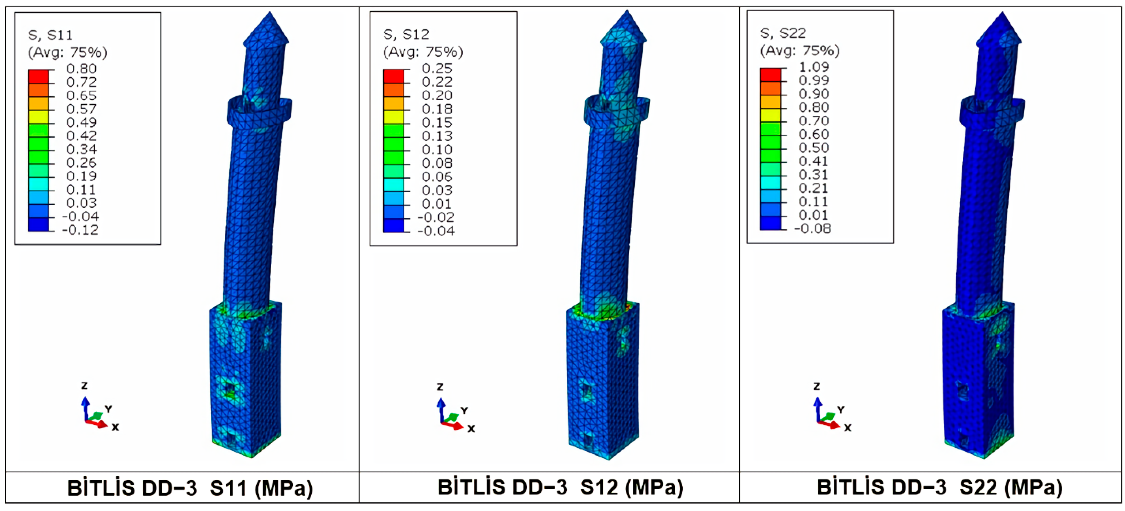
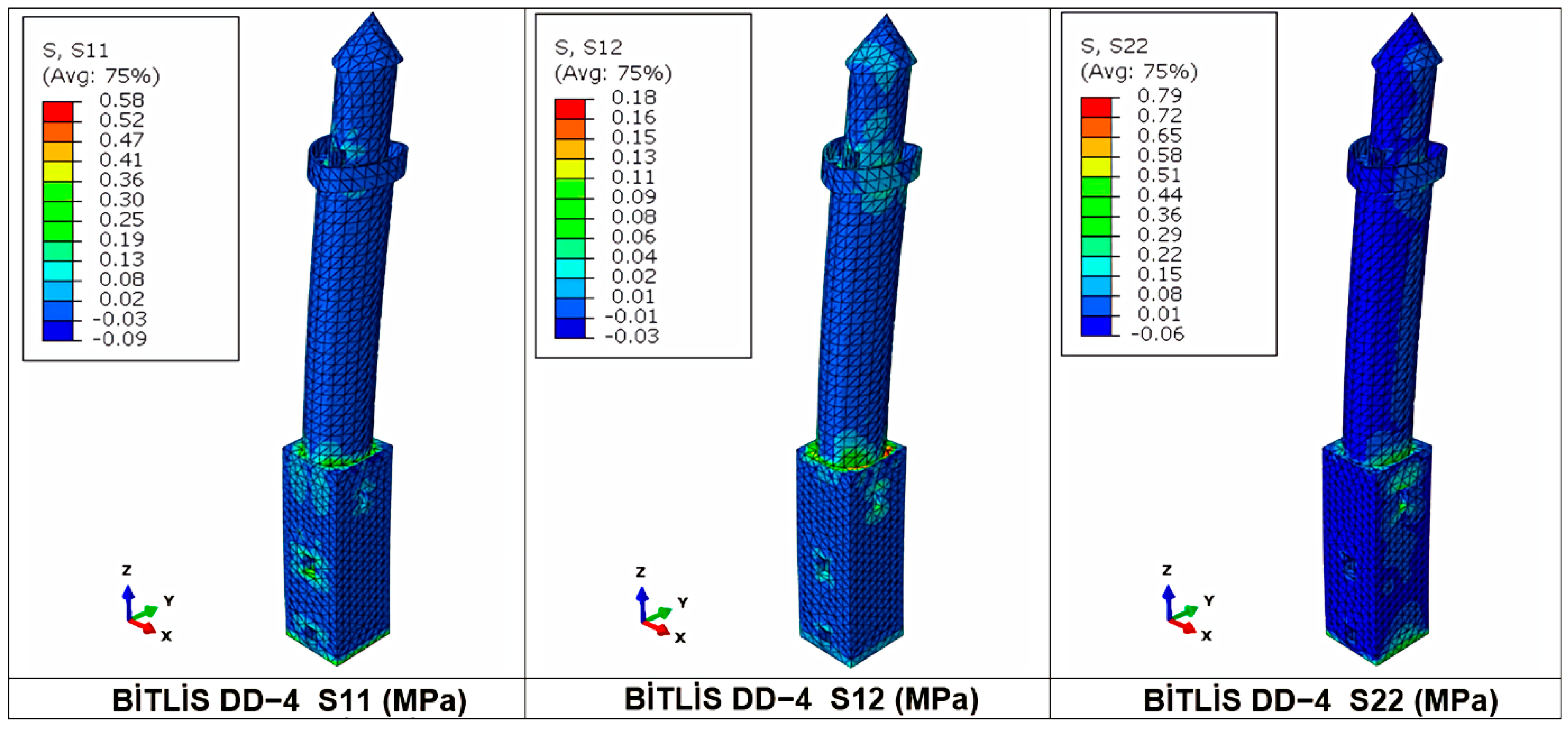
An Abaqus response spectrum analysis was used to estimate the peak response parameters (displacement, stress and base shear force) of the minaret. The stresses distribution in the minaret is shown in
Figure 21. Since the same design spectrum curve was used for seven different settlements considered in the study and located in the same earthquake zone, the same stresses would be obtained. The stress diagrams obtained for the largest earthquake ground motion level (DD-1) with a 2% probability of exceedance in 50 years are shown in
Figure 22. The stress diagrams obtained for the standard design earthquake ground motion level (DD-2) with a 10% probability of exceedance in 50 years and a recurrence period of 475 years are shown in
Figure 23. The stress diagrams obtained for the frequent earthquake ground motion level (DD-3), which has a 50% probability of exceedance in 50 years, are shown in
Figure 24. The stress diagrams obtained for the service earthquake ground motion level (DD-4), which has a 68% probability of exceedance in 50 years, are shown in
Figure 25.
The comparison of the maximum displacement, base shear force and stress values obtained for the ground motion levels with different probabilities for the minaret of Bitlis Ulu Mosque is given in
Table 11.
The largest displacement, base shear force and stress values were obtained for DD-1 and the lowest values were obtained for DD-4. Different values were obtained for the standard design ground motion level (DD-2) in both earthquake codes. For this ground motion level, the largest displacement value for the previous regulation was 0.38 m, while it was 0.21 m with the current regulation. The stresses obtained for the 2007 regulation decreased by approximately 45% compared to those of the current regulation. The displacement value obtained for the DD-1 ground motion level increased by 129% compared to that of the DD-2 ground motion level. In the previous regulation, only one ground motion level (DD-2) was taken into account, and since all selected settlements were located in the same earthquake zone, the same displacement, base shear and same stresses were obtained. With the current regulation, different values were obtained for all selected settlements. A comparison of the obtained result values is shown in
Figure 26.
Performance levels were also determined by using the displacement values obtained in the study. For this purpose, the limit value assumptions specified in the Earthquake Risk Management Guide for Historical Buildings (TYDRYK-2017) [
78] were used and these values are presented in
Figure 27. It is stated that it is sufficient to use linear calculation for the immediate occupancy (IO) performance level, and one of the linear or nonlinear calculation methods for the life safety (LS) and collapse prevention (CP) performance levels. If one of these calculation methods is selected, the minimum limit values that must be provided are shown.
The performance levels obtained for the DD-2 earthquake as the standard ground motion level, which is predicted in TSDC-2007 and TBEC-2018, are shown in
Table 12.
The values obtained for the standard design earthquake ground motion level (DD-2) were taken into account as the maximum displacement values. The maximum drift (%) was obtained by dividing the obtained maximum displacement value by the minaret height. The target displacement values for the performance levels were obtained by multiplying the marginal percentages of the minaret height under the unmitigated earthquake effect seen in TYDRYK-2017 (
Figure 27). Considering the displacement value obtained for TSDC-2007, it was determined that it did not satisfy the limit states for three different performance levels, but the value obtained for TBEC-2018 satisfies the life safety and collapse prevention performance levels.
5.2. Influence of the Site-Specific Design Spectrum
In this part of the study, the effect of the site-specific design spectrum, which is one of the important changes between the last two earthquake codes, is examined. In the previous regulation, site-specific seismicity effects were neglected by using the same design spectrum for the same earthquake zone. The fact that each geographical location has unique seismic parameters requires a differentiation of the design spectra. In order to show the difference, the stresses occurring for Kocaeli Province, which has the highest PGA value among the settlement units considered within the scope of the study, are shown in
Figure 28, while the stresses occurring in the minaret of the Ulu Mosque, which was chosen as an example for Siirt with the lowest PGA value, are shown in
Figure 29. During this comparison, no changes were made in the structural characteristics, material properties and local soil class of the minaret. The only variable was the design spectrum specific to each settlement. The importance of using the site-specific design spectra is shown.
The comparison of the result values obtained for all settlements considered in the study is shown in
Table 13. The comparison of the displacement values obtained for the settlements is shown in
Figure 30.
With the current regulation, the design spectra obtained on a regional basis were replaced by the geographical-site-specific design spectra. While the same values used to be obtained for all the settlements in that earthquake zone, different values can be obtained for the settlements within the region. This clearly shows that structural analyses should be performed using site-specific seismic parameters. Using the design spectra stipulated in the previous regulation, the same values were obtained within the same region, whereas each geographic location has its unique seismic parameters and will be subjected to different levels of shakings. The highest displacement, base shear force and stress values were obtained for Kocaeli, which has the highest PGA value, while the lowest values were obtained for the province of Siirt, which had the lowest PGA value. While higher values were obtained for Aydın, Amasya and Kocaeli in the new regulation, lower values were obtained for the other settlements. The comparison of the performance levels for the settlements considered in the study is shown in
Table 14.
The values in
Table 13 were obtained by taking into account the calculation principles considered in
Table 11. For the settlements located in the same earthquake zone, the same values were obtained in the previous regulation, and it was determined that the limit conditions foreseen for the three performance levels were exceeded. For Siirt, Bitlis, Osmaniye and Çankırı, it was concluded that the limit states were exceeded for the other settlements, while the CP level was achieved.
5.3. Dynamic Time History Analysis
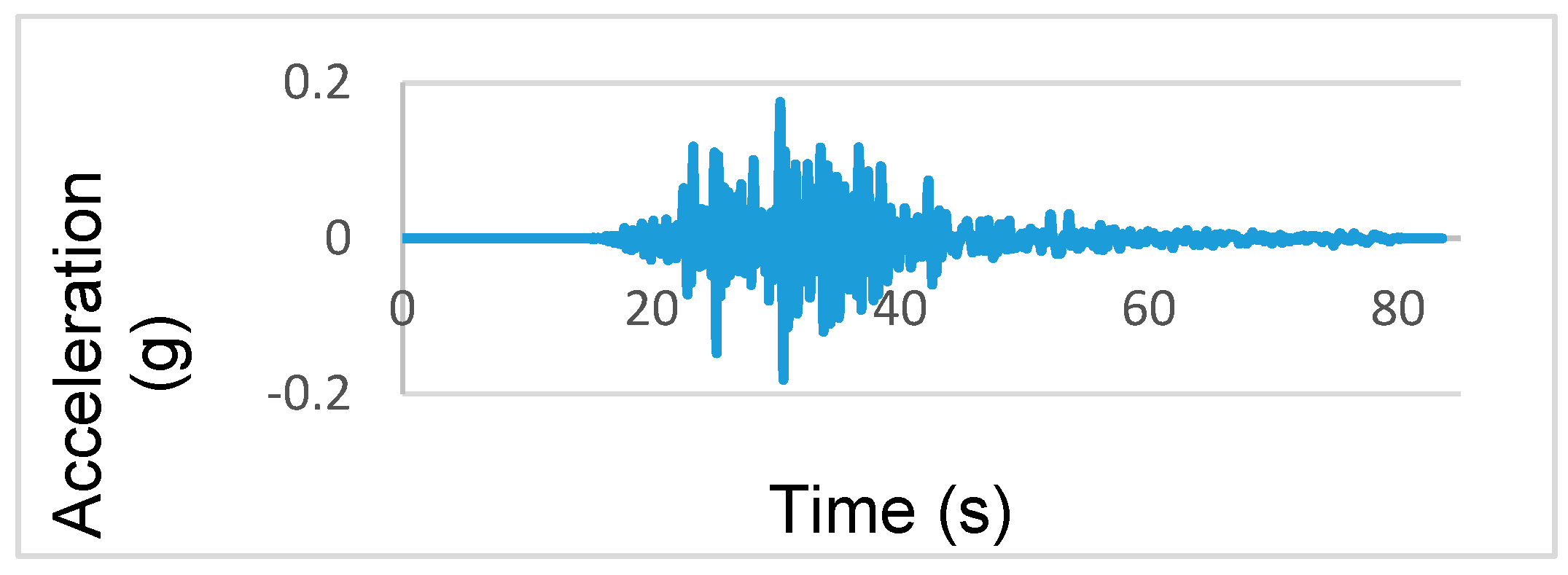
Time history analysis is the numerical analysis of the equation of motion, which is created by considering the mass, damping and stiffness properties of the structure, under a selected ground motion. In this part of the study, time history analyses were carried out by using the acceleration records of the 2011 Van earthquake, which occurred recently in the closest region to the Bitlis Ulu Mosque’s minaret. The Van Earthquake south–north acceleration–time curve of this considered earthquake is shown in
Figure 31. Solid elements were used in the construction of the finite element model under the presumption that the structure’s materials were homogeneous, and a linear elastic material model was used for the time history analysis.
The displacement–time graph obtained as a result of the time history analysis is shown in
Figure 32 by using the 2011 Van earthquake south–north acceleration–time curve.
As a result of the 2011 Van earthquake acceleration record, it was obtained that the minaret of the Ulu Mosque’s minaret had a maximum displacement of 0.17 m. This value was lower than the displacement values of 0.38 m and 0.21 m determined for the last two earthquake codes. Considering the displacement value obtained for the 2011 Van earthquake, the performance levels are shown in
Table 15.
The minaret performance level was obtained as life safety according to the largest displacement value obtained by considering the 2011 Van earthquake acceleration record.
6. Conclusions
Within the scope of this study, ground motion levels with different exceedance probabilities and different design spectra in masonry structures were chosen as variables. As a case study, the minaret of the historical Ulu Mosque in the province of Bitlis (Turkey) was chosen. This minaret is one of the Five Minarets, one of the symbolic structures of Bitlis Province, and is an invaluable part of the historical heritage. For this minaret, a structural model was created with the finite element method and analyses were carried out separately for different settlements. Finally, the current situation of the mosque and minaret was determined based on on-site measurements and observations, and solution suggestions were discussed.
Using the seismicity parameters and predicted design spectra in the last two earthquake hazard maps and regulations in Turkey, the seismic behavior of this minaret under the influence of earthquakes was compared. In recent years, with the use of site-specific design spectra, the variation of the amplitude of the design spectra and the PGA value significantly changed, resulting in different response estimations in many countries [
36,
57,
79,
80]. While the same seismic and structural parameters were used for the selected seven different settlements with the same seismic risk in the previous earthquake hazard map, completely different seismic and structural parameters were used together with the current earthquake hazard map and regulation for Turkey. As a result, the results of the structural analysis differed completely. In the seismic parameters, along with the current map, increases in some settlements and decreases in others were observed. This allowed for more realistic earthquake hazard and structural analyses of the seismic and structural parameters to be obtained according to the geographical location.
Both seismic and structural parameters for different ground motion levels were obtained, which is one of the innovations in the current earthquake code and one of the variables of this study. As the probability of exceedance increases, the earthquake effect that the structure will be exposed to decreases and as a result, the displacement, base shear force and stress values decrease.
Maximum stress levels occurred in the transition zones between the parts of the minaret in different settlements and different probability of exceedance. The resulting stress values were lower than the allowable stress values suggested in the literature for both Bitlis stone and natural stones. This proved once again that the engineering knowledge and experience at the time the minarets were built were very high. When necessary, monitoring the Ulu Mosque and its minaret by the relevant institutions/organizations and the timely engineering interventions minimized the destruction and damage that may occur to the structure. From this point of view, the originality of this minaret has been preserved by the necessary works and procedures until today. The continuity of monitoring and intervention processes related to such structures, which are an important part of the historical and cultural heritage, is very important for transferring such structures to the next generations.
The maximum displacement value obtained by considering the 2011 Van earthquake, located in the closest environment to Bitlis Province, was lower than the values predicted in the last two regulations. This can be considered as an indication that the last two regulations provide a certain level of safety.
It is known that Bitlis stone has low strength and is more damaged by abrasion due to its soft spongy feature. This situation is affected by temperature differences, frost and humid environments, causing fragmentation and rupture. The freeze–thaw effect, which is cyclical especially in cold periods, is one of the most important factors in the deterioration of the building blocks in the region. This poses a risk to the minaret and mosque. Therefore, the loss and destruction of the Bitlis stone, which is the main element of the minaret, over time due to the natural process may affect the load-bearing feature of the structure.
The surrounding of the monument should be considered together with the city infrastructure in order to drain the ground water from the building. Chemical and mechanical cleaning should be done in the planted parts. After this stage, the damages caused by moisture in the building should be monitored periodically by the relevant public institutions and organizations.
The almost disappearance of traditional construction methods and building construction has similarly affected the number of qualified personnel who understand this business. The use of contemporary materials and techniques is also required from time to time. As a result of these two situations, faulty productions occur in the details of the repairs. In this context, masters should be trained through local governments, and contemporary materials and techniques should be reconsidered with original details.
Timely interventions by the relevant public institutions and organizations did not allow us to obtain data on cracks or significant damage in the minaret. Therefore, the effect of the resulting stresses on the minaret could not be clearly demonstrated. The continuity of these processes is important for the structure.
Interventions on damage that may occur over time in a timely manner and in a way that preserves the structure’s originality are important in terms of transferring our historical heritage to the next generations. In this context, it is necessary to examine and monitor the structural health of historical buildings. The best way to protect our cultural heritage is to make necessary interventions in the light of experimental and numerical studies to be carried out on historical buildings before they are damaged.
The minaret of Bitlis Ulu Mosque, one of the first mosques of the Anatolian Principalities period, is a unique structure with multiple entrances at different elevations. The fact that Bitlis contains traces of the occupation years has an important place in terms of the memory of the city, but it is an important landmark of the city in terms of its location. This study can be used as a source for the structural health of the minaret.
In future studies, similar structural analyses will be carried out by using the micromodeling technique and by determining the material properties in more detail using experimental methods. The modal frequencies and mode shapes for the minaret of the Ulu Mosque were determined by a numerical model. In addition, modal parameters can be obtained by performing different techniques and field ambient vibration tests on the minaret. This study can be a source for such studies.


 ,
, 


