Article

Reconfiguring Vertical Urbanism: The Example of Tall Buildings and Transit-Oriented Development (TB-TOD) in Hong Kong

1
Department of Urban Planning and Policy, University of Illinois at Chicago, Chicago, IL 60607, USA
2
Department of Architecture and Civil Engineering, City University of Hong Kong, Kowloon B6322, Hong Kong
3
School of Architecture and Urban Planning, Shenzhen University, Shenzhen 518060, China
*
Author to whom correspondence should be addressed.
Buildings 2022, 12(2), 197; https://doi.org/10.3390/buildings12020197
Submission received: 5 January 2022 / Revised: 31 January 2022 / Accepted: 4 February 2022 / Published: 9 February 2022
(This article belongs to the Special Issue Recent Advances in Sustainable Vertical Urbanism)

Abstract

:
As the world moves toward becoming 70% urbanized by 2050, urban density becomes imperative in decisions on the urban environment and living quality. This paper builds on the polycentric and “rail village” development model that applies a “concentrated” density in strategic locations to create hyper-connected, socially vibrant hubs. Notably, it proposes the Tall Buildings and Transit-Oriented Development (TB-TOD) model, a type of development that refers to vertical mixed-use developments centered on mass transit nodes, as a sustainable option for large cities going forward. The key factors that promote the TB-TOD model are the efficient use of costly land, increased population density, boosted ridership, better regional connectivity, more sensible suburban growth, and improved placemaking. The paper examines the relationship between high-rise buildings and TOD in Hong Kong. The paper identifies and compares four types of TOD model, including “plug-in” TOD in the old city; city-edge TOD; “one building” TOD; and suburban TOD in the new area. Overall, this study documents urban design prototypes applicable to cities facing the challenges of high urban density and an excessive population.

1. Introduction

1.1. Background

In the past two decades, the world has witnessed the construction of an unprecedented number of tall buildings with increasing heights. Cities have been adding thousands of tall buildings and hundreds of supertall buildings (buildings with a height of 300 m or greater) [1]. Today, many cities are building skyscrapers hastily due to such factors as massive globalization, rapid urban population increases, intense urban regeneration, extensive agglomeration, soaring land prices, a dire need for land preservation, greed, and vanity. These factors in combination have prompted the world to construct high-rises excessively. Table 1 shows that the total number of tall buildings that the world built in the 21st century (7479) is almost double the number it built before that (3882) [2]. The table also shows that Asia has become the world’s champion in constructing tall buildings and that this has happened just in the past two decades, increasing the total from about one to five thousand buildings.
However, a tall building constitutes an integral spatial unit in the modern and future city. It is a density game-changer. Tall buildings could significantly impact density, utilities, infrastructure, placemaking, and imageability. Unfortunately, many cities lack guidelines on the spatial allocation of these buildings. They often follow the North American model, which features a robust spatial dichotomy, either a concentration of tall buildings (creating downtown) or a massive low-rise sprawl. This model has proven unsustainable for central business districts because they have become highly congested, polluted, and unpleasant. In contrast, suburbia has expanded intolerably, consuming much of the valuable land and damaging ecological systems [1,3].
A polycentric spatial pattern is one of the alternative urban growth models. Conceptually, urban planners have presented this model since the middle of the previous century. Empirically, few regions have been able to apply it due to a lack of the required transport infrastructure. The polycentric model relies largely on a rail transit system that must be efficient, covering large swaths of land. Interestingly, Hong Kong was one of the first cities to apply the polycentric model since rail transport was a core element in its urban development. Consequently, Hong Kong constitutes a unique case study for examining the polycentric model. This paper investigates the nuances of this model in terms of spatial pattern, density, and areas of service. It also identifies distinct typologies that can be used to understand better the polycentric model and its possible applications in other cities.

1.2. Objectives

This paper examines an alternative urban growth model that engages tall buildings with TOD. We refer to it as the Tall Buildings and Transit-Oriented Development (TB-TOD) model. In this model, a concentration of high-rises is purposefully placed around rail mass-transit nodes to boost density while integrating mixed-use functions that enliven the transit area and support multi-purpose trips. Recently, the TB-TOD model has demonstrated global appeal. In his writing, George Binder explains that “[m]any of the tallest buildings now under construction are centerpieces of vast, fully integrated master plans, with transportation considerations playing a major role in allowing people to conveniently access the site through multimodal means” [4]. We see prominent examples in the United States (e.g., Brickell City Center, the redevelopment of the WTC, and Hudson Yards) and in China (e.g., Wuhan Tiandi Site A, the KK100, the Ping An Finance Center, the Guangzhou CTF Finance Center, and Raffles City). This paper examines case studies of TB-TOD in Hong Kong and aims to identify typologies [5]. Future studies may examine TB-TOD in other cities.

1.3. The TB-TOD Model

The crucial aspects that support the TB-TOD model are numerous. They include high land prices around mass-transit nodes, the need for a high concentration of people around mass-transit nodes to increase ridership and sales activities, curbing horizontal expansion (sprawl), and fostering a sense of place.

1.3.1. High Land Prices near Rail Stations

Transit node areas are considered “hot” real estate. They are often sold at higher prices than elsewhere due to the connectivity that mass transit provides. The “transit premium” concept applies here, referring to the “betterment” that public transit offers, raising property values by multiple folds. Consequently, for land buyers to offset high land costs, they are often obliged to increase the number of units and spaces for selling and renting by building upward [1,6].

1.3.2. Increasing Ridership

Intuitively, a concentration of high-rise buildings increases the number of people who use mass transit, increasing daily ridership. Simply, without adequate ridership, it is hard to sustain mass transit systems. These systems are already costly to build and operate, and, consequently, it is crucial to ensure adequate revenues. Indeed, a mutually supportive relationship does exist between high-rises and rail transit. While high-rises can supply the ridership volume needed to sustain rail transit, rail transit offers a cleaner means to move around a more significant number of crowds. Railways have robust capacity. For example, a single transit track can carry between 40,000–70,000 passengers per hour [7,8]; these figures are multiple folds of a typical automobile highway. Therefore, locating high-rises close to train stations offers a mutually beneficial outcome, as high-rises supply a sustainable ridership characterized as inexpensive, convenient, and “green”. In contrast, skyscrapers’ sustainability is seriously questioned when they do not integrate into a transport system [5].

1.3.3. Supporting Mixed-Use Activities

In addition to supporting ridership, a concentration of people in an area (often provided by high-rises) can also support mixed-use activities. In other words, increasing the population density creates a more significant and more immediate consumer base for businesses, shops, retails, restaurants, cafes, office spaces, and commercial activities. Therefore, the TB-TOD model requires the integration of a mixed-use planning scheme. That is, by supporting high-rises and rail transit with mixed-use functions, a socioeconomic synergy emerges as passengers flow to and from stations, creating sustained clienteles. By placing residential, commercial, retail, amenities, and services near each other, the TB-TOD model shortens trips and generates “multi-purpose” trips. For example, by placing the retail frontage along the pathways leading to a transit station, passengers can shop and eat on their way to the station. These activities provide retail income, enliven the public realm, and foster a sense of place. A well-maintained, mixed-use, walkable environment stimulates pedestrians’ senses and encourages them to walk, stay for a longer time, and spend more [9,10,11,12].

1.3.4. Accommodating a Substantial Number of Activities in a Limited Space

Accommodating many activities around mass transit stations demands space on the ground floor, necessitating upward building. That is, the transit catchment area, which has a 0.5 m (0.8 km) radius, is often busy with activities such as the street network that feeds into mass transit stations, sidewalks, bike lanes, parking, taxi lanes, bus and minibus stops, drop-off and pick-up spaces, retails, cafes, eatery places, shops, plazas, landscaping, the indoor and outdoor spaces required to accommodate flows of passengers in and out of mass transit stations, and inner circulation (escalators, elevators, stairs, and ramps). These activities eat up much of the ground floor, and developers need to build upward to accommodate other essential spaces such as residential, office, and commercial spaces [13,14,15,16,17].

1.3.5. Curbing Sprawl

Overall, “transit villages” or TB-TOD can help curb sprawl by concentrating masses of people around mass transit stations. Tangible benefits include reducing land consumption, vehicle miles traveled (VMT), and associated air pollution. In contrast, major highway networks that facilitate sprawl have supported locating tall buildings away from the city, for example, near airports or in pockets (office parks) near highway exits. These models have encouraged sprawl and proven to be less sustainable as freeways became congested, defeating the ease of mobility they initially offered. Further, excessive automobile travel has generated a significant amount of air pollution. Therefore, transit villages are better for locating tall buildings [3,6,18,19,20].

1.3.6. Fostering a Sense of Place

Simply, a place without people and activities is dead. The TB-TOD model clusters mixed-use functions and people who collectively foster a sense of place. Often, the flows of passengers in and out of mass-transit nodes animate the space, and commercial and retail activities enliven the space. On the vertical plane, tall buildings around mass transit stations could denote the locations of transit nodes viewed from close up or far away. When they are placed strategically around mass-transit nodes, tall buildings create focal points on the skyline, improving the city’s imageability and navigability [21,22,23].

1.3.7. Economic Gain
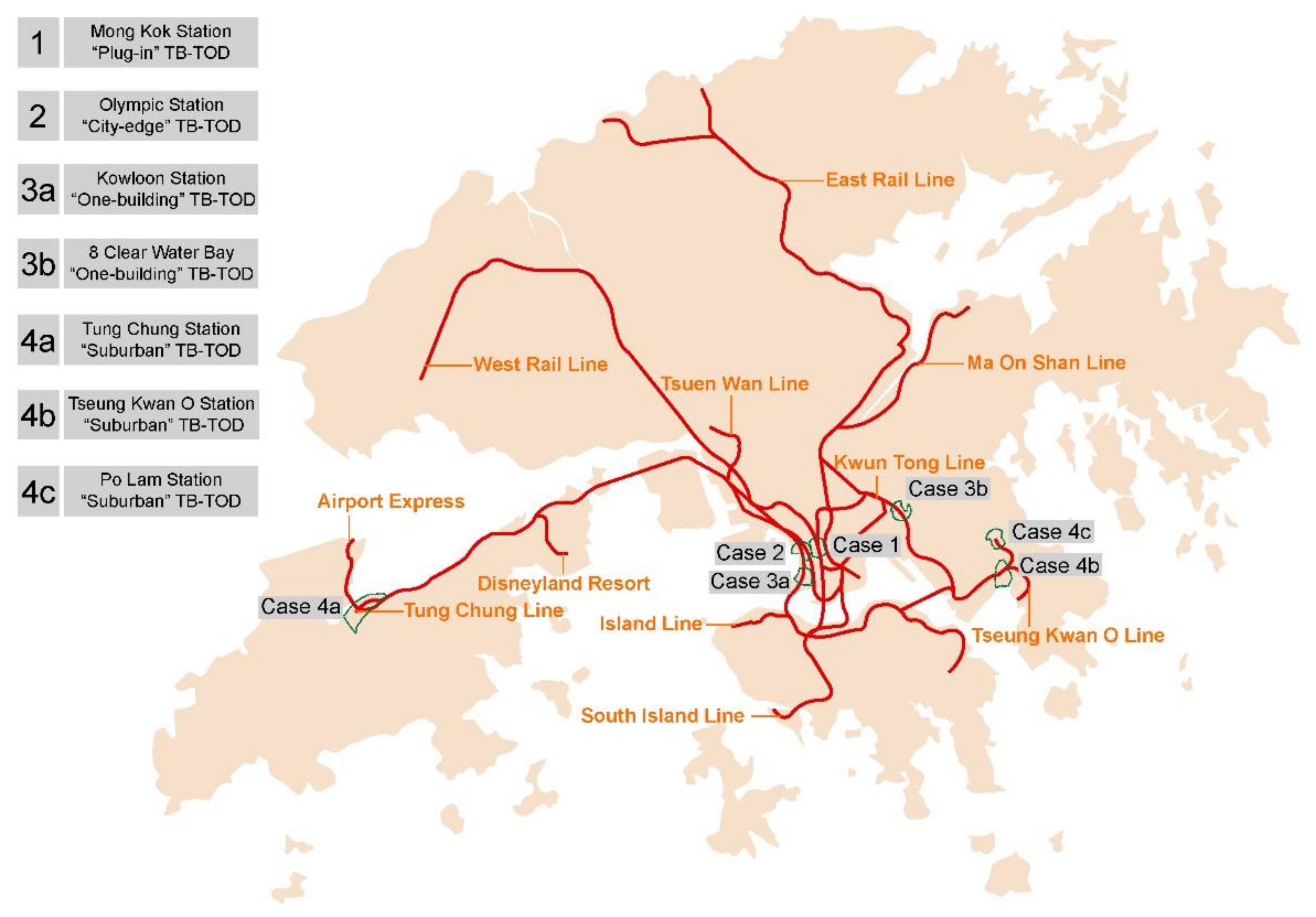
Clustering tall buildings around central transport nodes increases travel efficiency, leading to multiple economic benefits. Efficient travel saves passengers time that they could utilize in their workplace, improving their productivity. The clustering supports businesses by making distances among them walkable. Further, clustering creates significant agglomeration benefits. One study has compared the economic benefit of placing 80,000 employees near transport nodes versus elsewhere in London. The study found that the first scenario resulted in an economic increase of 2500 GBP a year for each employee. Such studies have supported the polycentric transit-rail model in the urban growth in London and the United Kingdom [5,24].

2. Case Studies

Hong Kong has a wealth of experience in dealing with high density. Hong Kong has a population of 7.4 million inhabitants, with geographic coverage of 1103 km2, built area of 267 km2 and a population density of 27,000 people per km2 [2]. Additionally, Hong Kong offers a good lesson on rail transport. It started constructing a subway system (the Mass Transit Railway, MTR) in the late 1970s. Now, this 256-km-long railway extends from the city’s heart to the New Territories like a system of branching veins. Of Hong Kong’s 7.4 million residents, 5 million use the MTR daily (mtr.com.hk online report). The majority of its 96 stations serve as centers for living and working. This is known as the “rail + property” or “rail village” development model [21,25].
Overall, the planning tasks of Hong Kong focus on two things: renewing the old city and making a new town. Through decades of rail stations and their TODs, our research identified four prominent types: (1) “plug-in” TOD in the old city (exemplified by Mong Kok Station); (2) city-edge TOD in old city expansion (exemplified by Olympic Station); (3) “one-building TOD”, a typical Hong Kong phenomenon (Tung Chung Station and Choi Hung Station are examples); and (4) suburban TOD in remote new areas (Tung Chung Station, Tseung Kwan O Station, and Po Lam Station are examples). This section presents these four types of TB-TOD and shows how tall buildings have been incorporated into their catchment areas [26,27,28,29] (Figure 1). In the case studies, we explain why this station represents this type of TB-TOD. They are usually the oldest, densest, or largest in their respective type. In each case, we pay attention to several indexes that indicate the effectiveness of high-density living and pedestrian-oriented transportation. These indexes include the radius and scope of the catchment area, the building typology, the shape of the building, the total gross floor area (GFA), and subway exit types. After the analysis of the cases, all these indexes are summarized in Table 5 in the discussion section.

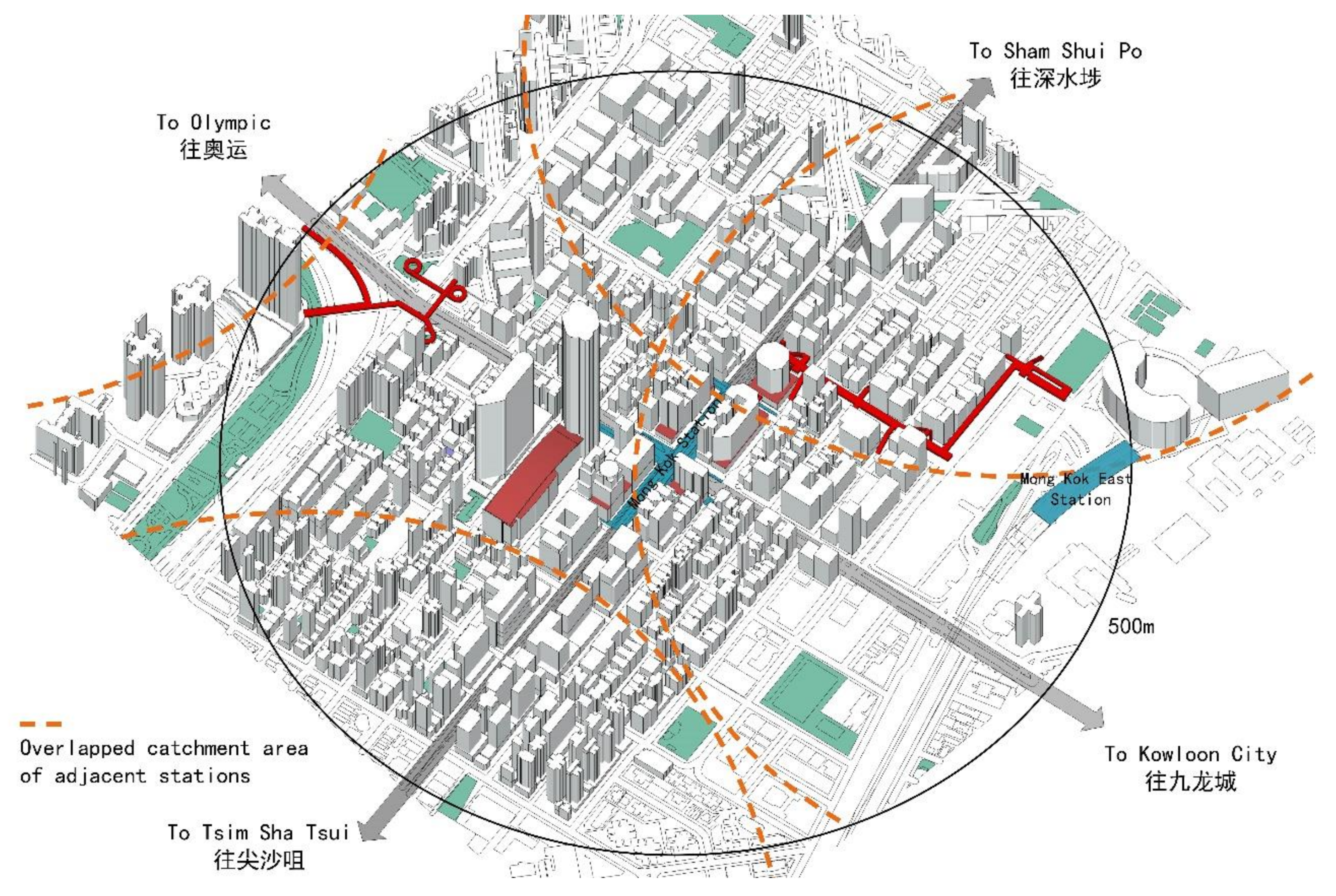
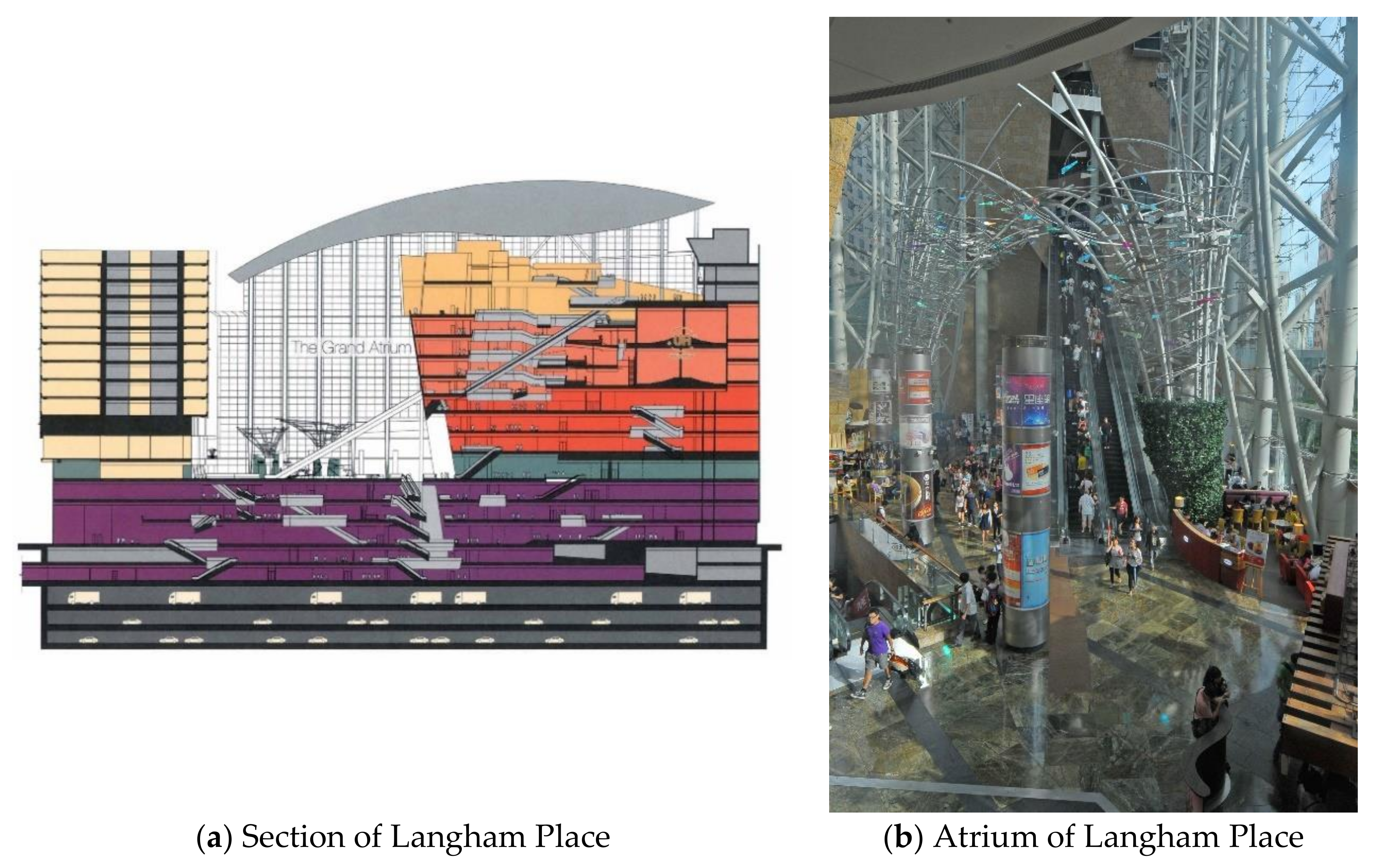
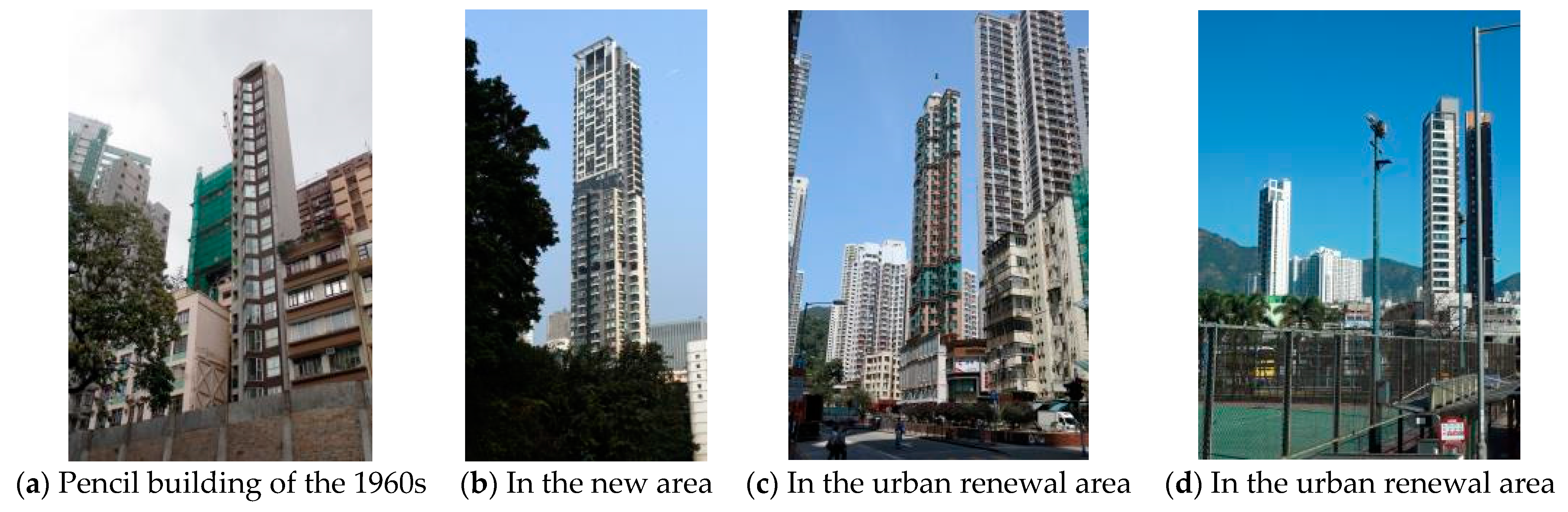
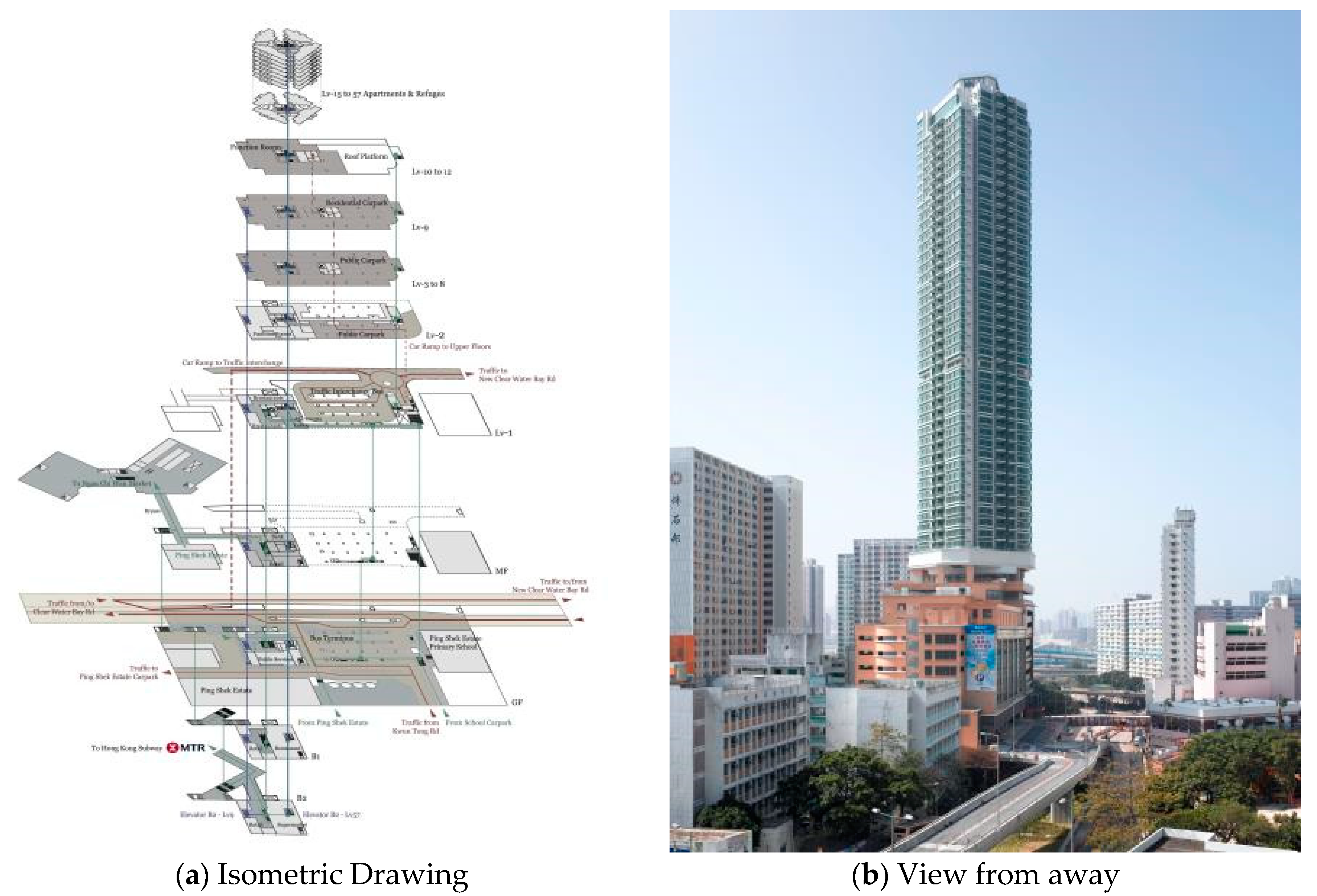
2.1. “Plug-In” TB-TOD in the Old City

Hong Kong’s first metro line, the Kwun Tong Line, was completed in 1979, and the Hong Kong Island Line was completed in 1985. The early MTR lines dived into old parts of the city, which are densely populated, to quickly resolve the traffic problems and serve masses of people. Street blocks, buildings, and businesses existed long before the construction of the MTR. As such, “plugging in” metro lines and stations offered opportunities for urban renewal and sometimes gentrification, which the residents long expected. Here, we use Mong Kok, in the heart of the Kowloon Peninsula, as an example of plug-in TB-TOD. This area was formed from vegetable fields in the 1930s; it is now the busiest street retail business area and is patronized by many young people. There are other old city areas along the first-generation subway line. However, they are not as famous, dense, and diversified as Mong Kok, which is more significant than the other areas and created overlapping effects with nearby subway stations [25,30].
With heavy vehicular traffic, several roads running from east to west and south to north are thoroughfares in the Kowloon Peninsula, such as Nathan Road, Argyle Street, and Mong Kok Road. Taking the Mong Kok MTR station as the center, a circle with a 500-m or 800-m catchment radius will overlap with equivalent circles for the Mong Kok East (East Rail), Prince Edward, Yaumatai, and Olympic (Tung Chung Line) stations. The overlap between Mong Kok, Mong Kok East, Prince Edward, and Yaumatai contains hundreds of street blocks, whose plot area is mainly around 50 × 50 m or 50 × 100 m, which were planned in the 1930s. Numerous mixed-use buildings (commercial and residential) can be found in the blocks [26,31,32].
Mong Kok constructed most of its buildings in the 1960s and 1970s. The floor plates of these buildings usually measure 20–30 m or less. Upon deducting staircases, elevators, and bathrooms, the usable floor area ranges between 50 and 100 square meters. According to the usual practice of tall building design, a reasonable floor plate may be around 1000 sq.m in size. A 100 sq.m. floor plate is regarded as not “economical”. However, this is the reality of the old city area in Hong Kong. The buildings are 20–30 stories high. Their first three to six levels are usually in the “Ginza” style, with eateries, coffee shops, restaurants, and small shops or hawkers selling electronic appliances, watches, jewelry, and sports shoes. The upper floors sometimes house tourism agencies, opticians, medical clinics, hair salons, or pharmacies. In this area, several streets, such as Ladies’ Market, Sai Yeung Choi Street (electronic products), and Sneaker Street, are dedicated to hawkers and pedestrianized in the afternoon or on the weekend. This place is unique because it integrates high-, medium-, and low-consumption areas. Advertisements, billboards, and neon signs are hung irregularly above the streets, blocking the view of the sky. Compared with Hong Kong’s new suburban areas (discussed in the case studies below), Mong Kok has smaller blocks, but its buildings grow densely in the form of a “mat”. The MTR brings many customers to the Ginza-style shops from early morning to late evening [21,33,34,35] (Figure 2).
When Hong Kong abandoned the Kai Tak Airport in 1998, it lifted the 120 m height restriction in the Mong Kok area. At the beginning of the 21st century, an expansive pedestrian bridge deck over the street was built on Mong Kok Road, linking the Mong Kok and Mong Kok East stations. The pedestrians to and from these two stations can be protected from rain and summer sunshine. The outlets of the bridge extend to the many perpendicular streets it covers. In such a compact area of the old city, new buildings must be built over demolished ones. Old buildings are bought and demolished every year, and new ones are constructed–fulfilling a kind of metabolism. The most notable is the commercial complex Langham Place on the west side of Nathan Road, which was completed in 2004. The Urban Renewal Authority (URA) obtained land and old-style apartments from many owners over a decade, and Great Eagle developed the complex. A shopping mall is one or two stories high in most Western cities, but Langham Place has 12 floors. Building regulations stipulate that a portion of the podium should not be enclosed at such a site. However, the building owner requested permission to install a glass cover. Accordingly, a 60-m-high atrium was created above the podium (Figure 3). The floors are linked by escalators, elevators, stairs, and spiral ramps [30,32,36].
Above the shopping mall are a high-rise hotel, The Langham, and an office tower, which houses companies of famous brands. The erection of Langham Place substantially changed the ecology of Mong Kok. Mahjong (Chinese gambling) pavilions and prostitute businesses moved out, and healthy businesses stepped in. The number of crimes decreased, and people feel safe. Housing and rental prices increased.

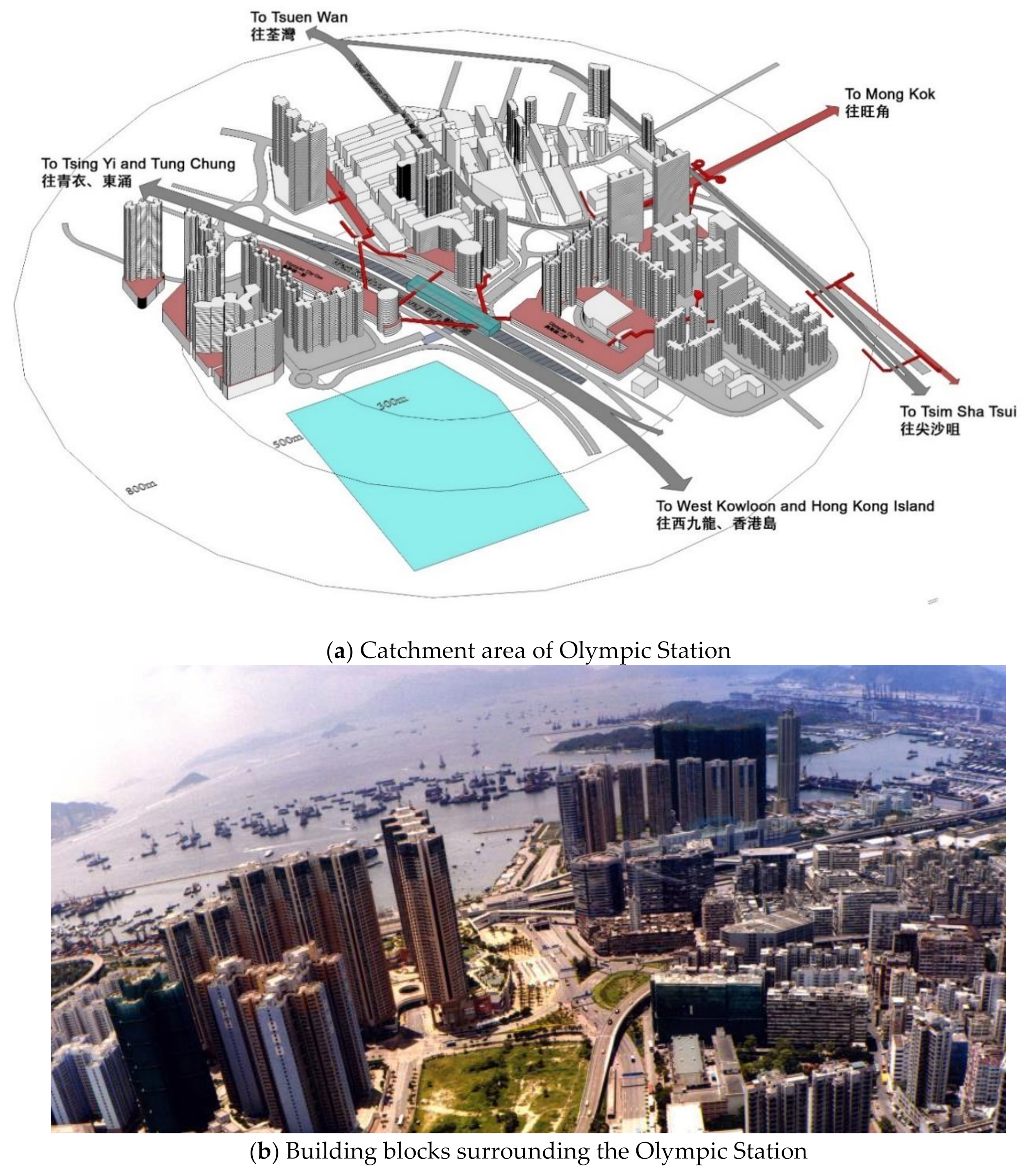
2.2. “City-Edge” TB-TOD

The development of Hong Kong, as a coastal city, relies significantly on reclamation. Since the mid-19th century, more than 80 sq. km of flat land has been created. The reclaimed land is used for new residential, scientific, business, and cultural purposes. Further, the reclaimed land belongs to the government, which plans and builds according to an ideal blueprint. The MTR extends to these areas, generating TODs at the city’s edge. Many of the reclaimed lands are planned to be used for a new town, as discussed in Section 2.4. Some of the reclaimed land adds to the city proper. The station is the largest in this category and is used as an example [25,31].
As with Kowloon Station and the Hong Kong Cultural Center, Olympic Station is built on reclaimed land that extends from Tai Kok Tsui and Mong Kok, both parts of the old city. The station is flanked by an expressway and linked to its catchment area by six pedestrian bridges like an octopus. The catchment area is around 600–800 m in radius, covering newly built residential areas, a shopping mall of three phases, and older parts of the city, such as the catchment area of Mong Kok Station and Tai Kok Tsui [26].
Based on materials provided by a property agency, we calculated that Olympic Station has a GFA of 15,660 square meters. The newly developed private residential estates include 35 building blocks and approximately 11,000 living units (as of 2021). High-rise residential blocks(35–60 stories)can be found along the coast, and most homes enjoy a sea view. On the other side of the station are the tall office buildings of the Bank of China and Hong Kong Bank. The shopping mall is divided into three parts, or “phases”, along the route between the station and the residential and office blocks. The three mall buildings have different shapes, as they were designed to suit their respective sites and define the street blocks. The Phase III shopping mall is designed to draw people away from the old Mong Kok area. The managers of the Sino shopping mall frequently hold activities such as big-screen showings of the World Cup and Olympic Games, which attract both local people and visitors [31].
Roads surround Olympic Station. All its exits are bridges leading to the Phase I, Phase II, and Phase III shopping malls, new housing estates, and old commercial areas. Pedestrians mainly use the podium level, where the main entrances to the high-rise housing blocks are located (Figure 4). The “plugging in” type of TOD is a provisional and practical strategy for renovating the old area. The main skeleton of the “city’s edge” has been elaboratively planned with urban design and TOD concepts. Of course, it also offers the opportunity to enhance the living quality of the old city area because of its location at the “edge”.

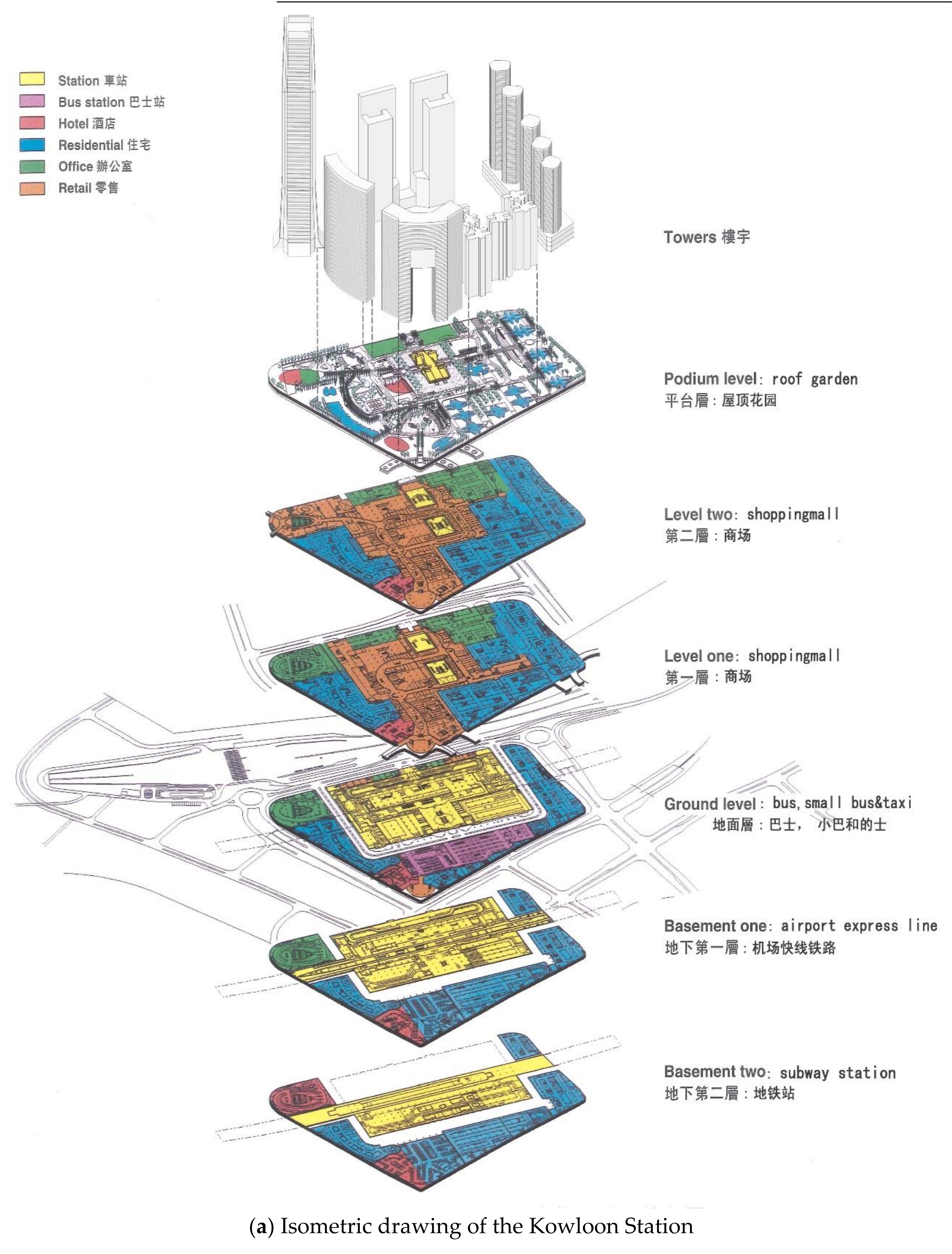
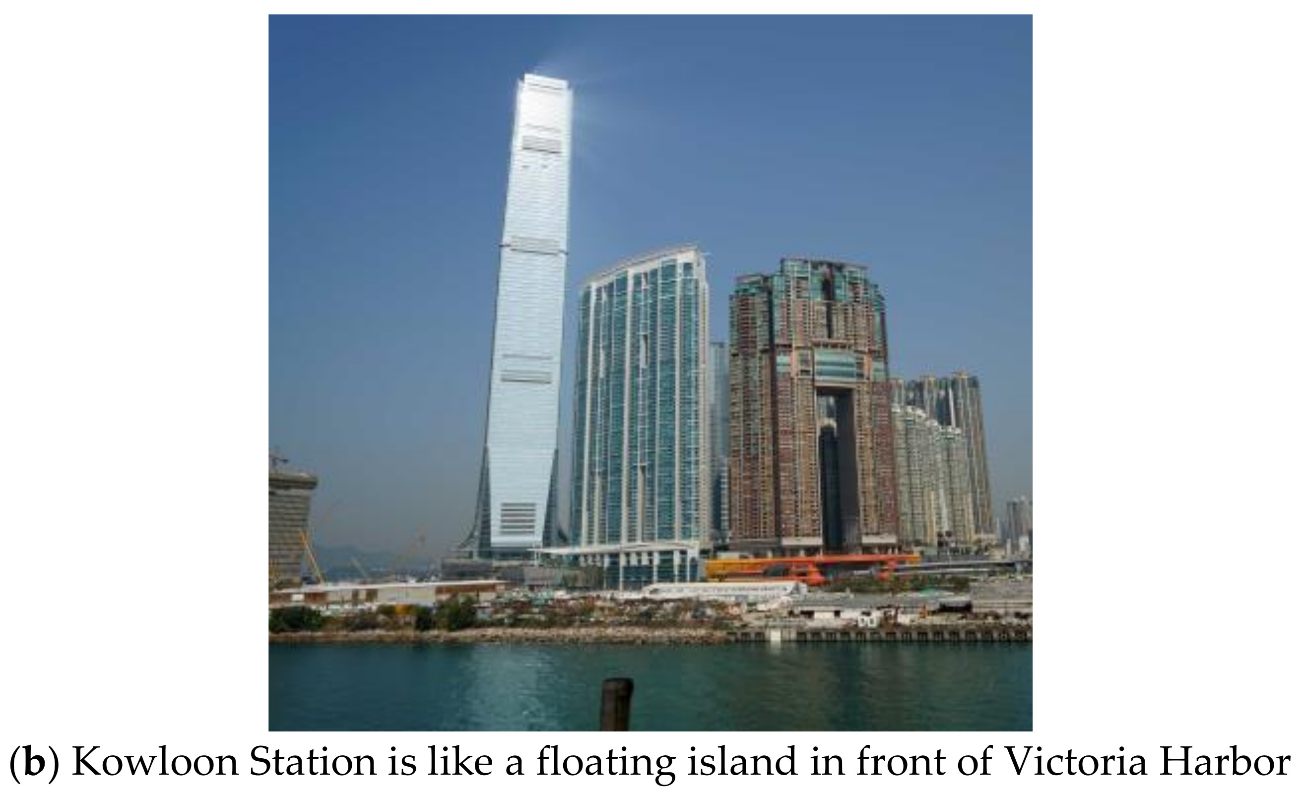
2.3. “One-Building” TB-TOD

Some TB-TOD areas in Hong Kong are made up of just one building, such as a megastructure or a pencil tower rising from the station podium (Figure 5).
Kowloon Station occupies 13 hectares. The total floor area of this megastructure is nearly 1.7 million square meters. The development includes a three-story public transport interchange with bus, minibus, and taxi stations at ground level, an ordinary MTR station on the Tung Chung Line, and an Airport Express Line station in the basement; a two-story shopping mall; a raised 18-m-high rooftop garden on the podium; 18 residential skyscrapers, ranging from 142 to 256 m high; and two 270-m-tall mixed-use buildings containing hotels, serviced apartments, and offices. The project also includes the 484-m-tall International Commerce Center (ICC), the tallest building in Hong Kong, which was designed by KPF and whose form echoes the 412-m-tall IFC Tower designed by Cesar Pelli opposite the harbor (Table 2). Both buildings are landmarks of Hong Kong (Figure 6). Simply put, it is a “transportation hub + iconic building + high-end shopping center + high-grade residential” development model [25,26,27].
However, Kowloon Station is like an island surrounded by roads, with few pedestrians entering the complex through the streets. People can access the station complex at the ground and basement levels via the subway or by car/bus/taxi, then enter the mall or transportation core of the high-rise buildings above. In addition to vertical connections, pedestrians can access the mall and the public roof terrace via the skywalk system at West Kowloon Station, which opened in late 2018, and at Austin Road Station, which opened in 2009. Although it is close to the old part of Yau Ma Tei, walking is not convenient. There is no street life here; all public life occurs within the Kowloon Station complex. Its maze-like shopping mall and huge podium allow people to meet in the rooftop gardens and enjoy views of the harbor beneath the skyscrapers, most of whom are users of these high-rise buildings. With the gradual opening of the West Kowloon Cultural District, Kowloon Station connects people from the MTR to the minibus station and the cultural megastructures [29,36].
In the early colonial period, urban land was divided into small pieces of about 20 × 30–40 feet. During the economic boom of the 1970s, buildings of 20, 30, or more stories were built on these well-drawn-out cubes, creating pencil towers all over Old Town. If Kowloon Station is an example of a megastructure form, bulky "one-building" TOD, then 8 Clearwater Bay Road (Rainbow Station) is a much slimmer version (Table 3). Interestingly, it is possible to view 8 Clearwater Bay Road as an enlarged version of the Pencil Tower (Figure 7).
The base of the building is approximately 25 × 30 m. Usually, the podium of a Hong Kong building has three floors. However, the podium of 8 Clearwater Bay Road has 12 floors. The basement seamlessly connects to the Choi Hung MTR station and houses several restaurants and a supermarket; the first two floors at ground level house bus and minibus stops, taxi stations, and various stores. A walkway system connects the building to the nearby public housing estate, community hall, and wet market. With a horizontal range of 100 m and vertical connections, people can meet most of their needs in daily life. Therefore, this is an example of a single building in an ultra-compact and mixed-use development combined with a subway station [28].
By comparing the two extreme cases with a 50-times difference in GFA, the authors found that both cases coincidentally adopt the vertical mixed development mode of transportation hub plus residential plus commercial, which shows that "one-building" TOD pays more attention to the design of the connection between the podium of the high-rise building and the rail transit station, the mixed-use development of the high-rise building, and the relationship of a rail station with other modes of transportation. One-building TODs are developed at a similar density, but the megastructure form has the following characteristics: huge blocks, massive architectural volumes, broad urban roads, and public spaces with unsatisfactory accessibility [31].

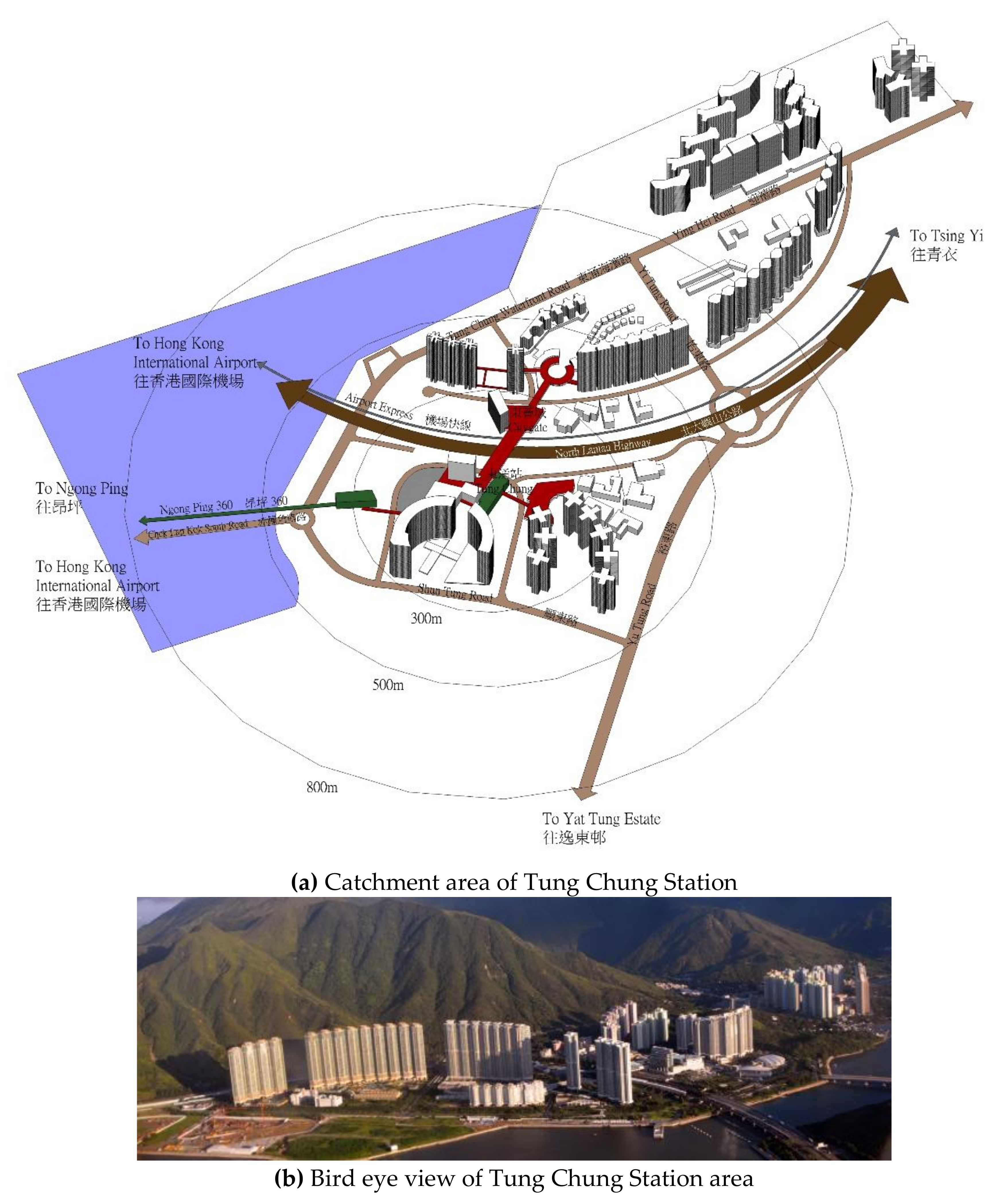
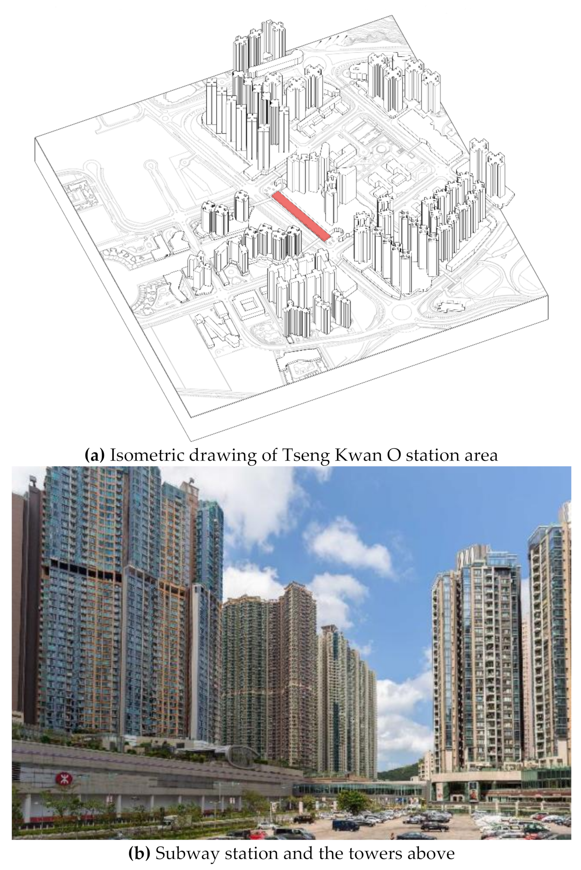
2.4. “Suburban” TB-TOD in New Areas

When the MTR line was extended to the east and west, planning authorities and the MTRC’s in-house urban designers designed new stations and TOD areas based on common standards and design principles. They planned the area with the rail station at the center, linking the station, streets, and buildings within the catchment area through vertical connections and an aerial walkway system. This planning scheme is particularly obvious in the Tung Chung and Tseng Kwan O lines built in the 21st century [25].
Originally a remote rural area, Tung Chung was planned as a new town with the Airport Core Programme in the 1990s, and its population has grown to about 150,000. Tung Chung Station serves as the terminal of the Tung Chung line. The citygate above is the center of the area and the largest outlet mall in Hong Kong, which brings a steady flow of people to Tung Chung Station. The citygate breaks the international consumer market’s perception of an outlet building form with the conventional Hong Kong mall form. As shown in Figure 8, rows of 60-story residential buildings are arranged along the mountains and coastline, with Tung Chung Railway Station as the axis. The exit of Tung Chung Station leads to the mall and public space with a musical fountain, and people can reach their homes, stores, and bus stops through them. Based on the fact that Lantau Island will become Hong Kong’s gateway to Mainland China and the world, Tung Chung will double in size as a critical node to welcome more high-rise residential buildings, both private and public, to take advantage of the large-scale public transportation infrastructure [31,36].
Suburban TOD can produce ultra-high-density developments, generally employing a mixed-use development model of commercial + residential + municipal supporting facilities. The entire Tseung Kwan O New Town covers an area of about 1790 hectares, including Po Lam, Hang Hau, Tseung Kwan O, and Lohas Park. Very few people lived in the valley area before 1990. When the Kwun Tong MTR line was expanded to Tseung Kwan O, a rail village was planned for more than 500,000 residents. A large shopping mall on the subway is located in the center of the village. Its roof has a sky garden for residents only and is surrounded by 50-story residential buildings. Almost all the buildings are within a radius of 500 m from the station, and even the catchment areas of some stations overlap. The streets near the station are mainly used by vehicles, and most pedestrians pass on the podium level and pedestrian bridges. Tung Chung Station is on its own at the far end of the railway line, and the five stations in Tseung Kwan O form a neighborhood cluster delineating the residential town [13,25,37] (Figure 9).
Although Tung Chung Station and Tseung Kwan O Station generally adopt the MTR plus more affordable high-rise residential complexes model, Tung Chung Station combines more affordable residential complexes with the outlet economy. At the same time, Tseung Kwan O Station uses a purely MTR-station-centric model of high-density residential and community commercial development (Table 4).

3. Discussion

3.1. TB-TOD Characteristics

Several factors influence the shaping of TB-TOD. These include building type and function, number of floors and shape of tall buildings, land-use mix, size of the catchment area, floor area of buildings in the catchment area, and location of exits. Table 5 shows how the abovementioned key factors differ between types of TODs.

3.2. Spatial Structuring

In terms of the spatial structuring of the TB-TOD model, taller and the tallest buildings should be placed closer to the station, and shorter buildings should be placed further away for the following reasons. First, prices of properties closer to the station are higher than those set away. In other words, the nearer to a station a property is, the more expensive the property will be. Second, placing taller buildings closer to a station will enable more tenants to reach the station with shorter distances. As such, many tenants will get to the station by taking an elevator trip and a short walk. Third, the resulting profile—with taller buildings near the station—visually denotes the station’s location, improving the sense of place. Fourth, the taller a building floor is, the higher its selling price or rental cost will be. Therefore, buildings close to stations tend to be taller. For land-use and floor plate efficiency reasons, some of these buildings tend to be slim—some refer to them as “pencil towers” or “needle towers” [5].
At the macro-scale, the TB-TOD model should help to craft a distinguishable skyline. Read as a unit, a skyline forms a potent urban symbol that manifests citizens’ achievements, economic status, cultural ambition, and lifestyle. An imageable skyline boosts the city’s reputation, reinforces civic life, and fosters pride. It also helps residents and visitors better orient themselves within the city and navigate through it. According to Kevin Lynch, a modern skyline is a “vertical edge” created by tall buildings. In the case of Hong Kong, tall buildings stretched along village transits help create a cohesive skyline. Though, in a few places, supertall buildings, such as Two IFC and Central Plaza rising to, respectively, 412 m (1351 ft) and 374 m (1227 ft), infringe upon the ridgelines of the surrounding mountains. Ridgelines are valuable tourist and visual assets, and their preservation should be given special consideration in the process of urban development. In response, Hong Kong has embraced urban design guidelines that dictate that at least a 20% building-free zone must be sustained against the backdrop of ridgelines from various viewing points. For example, the height of the Victoria Peak is around 545 m (1788 ft), so the 20% building-free zone is approximately 110 m (361 ft) below the Peak.

3.3. Human-Scale Environment and Placemaking

At the micro-scale, the TB-TOD model should support human-scaled architecture. This is particularly challenging since tall buildings damage the human scale due to their size and height. They are likely to exhibit what Jacobs and Appleyard call “giantism” [4]. Developments of massive tall buildings cause passersby to feel small, dwarfed, and irrelevant. However, there are opportunities to mitigate the overwhelming vertical scale through architectural design and landscaping at the pedestrian level. The tower base, shaft, landscaping, atriums, plazas, and sculptures are among these design elements.

3.3.1. The Ground Plane

Research emphasizes that the design of successful tall buildings is correlated to lively activities at the street level, such as strolling, sitting, and people watching [8,13]. Unfortunately, some tall buildings have turned their backs to the street by employing high, blank, windowless walls. In these cases, socioeconomic activities are forced inside and are afforded less access. Today, many tall buildings’ retail and social activities are internalized and segregated from the city’s social life, and their indoor spaces are disconnected from outdoor areas. They become isolated, rather than integrated, elements in the city. Earlier, Le Corbusier’s vertical neighborhood model brought socioeconomic activities into the building’s upper floors [13]. Depriving the ground level of a connected socioeconomic space decreases the vigor of that social life and diminishes its sense of place. In response to these problems, some city officials have recognized the importance of socioeconomic activities and have used incentives to encourage developers to design pedestrian facilities on the ground floor of their buildings [15].

3.3.2. The Tower Base

The architectural design, layout, and decoration of the base of tall buildings must respond to the human scale [12,13]. In this regard, architects have provided several design approaches. For example, Paul Rudolph suggested that the architectural design and perceptual characteristics of the first 30 m (98 ft) of the base of any tall building should respond to the human scale and contain intricate architectural treatments that viewers can appreciate at the street level [14]. Rudolph’s design approach is exemplified in many of his buildings, including the Lippo Center in Hong Kong.
Ludwig Mies van der Rohe suggested employing a more straightforward visual treatment by providing transparency that invites the viewer to look through the base. This is achieved by recessing the exterior walls of the ground floor and fronting the ground level with floor-to-ceiling windows, which can be seen in the design of the Richard J. Daley Center and the Kluczynski and Dirksen Federal Buildings in Chicago. Because the ground floor is transparent, it allows passersby to see through it and evokes an inviting and permeable entryway. The design of the 200 South Wacker Drive building employs a similar technique but in a creative way. It incorporates a three-story, glass-enclosed lobby set back from the perimeter, creating a pedestrian arcade. The exterior columns are set on an angle to optimize indoor/outdoor views.
Contemporary architects have provided creative solutions for making towers respect the human scale through a sensible, practical base design. Helmut Jahn provides different design approaches. For example, in the James R. Thompson Center in Chicago, also known as the State of Illinois Center, the tower tapers back and then caves in toward the base to minimize the problem of “tallness”.

3.3.3. Tower Articulation

Design articulation of a tower may assist in lessening its impact on the human scale [9]. For example, the AMRO building in Chicago employs multiple techniques to mitigate the negative impact. AMRO is a 140-m (458-ft), 29-story commercial skyscraper designed by DeStefano & Partners that can be viewed from 360°, making the height more tangible at the pedestrian level. The tower grows from a base along a well-designed plaza. The building design applies horizontal white stripes every several floors to evoke the illusion of fewer floors. Additionally, a focal horizontal band with vertical lines toward the tower’s base, forming a wide belt, is utilized to break up the massiveness of the facade. The tower’s edges are articulated with perforated steel frames that allow light to pass through and enrich the visual effect, reducing the building’s massiveness. Furthermore, the glass facade employs a light color scheme (white and whitish “snowy” blue), which makes the tower smoothly blend with the sky and reduces the tower’s perceived verticality and massiveness. One of the fascinating human elements within the structure is the placement of the building’s street address number. The tall steel pole that extends to the top of the building houses the “540 W Madison” address at the very bottom of the structure. This helps to bring the scale down to the human eye level.

3.3.4. Streetscape

Careful landscaping may help to restore human-scale environments [9]. In downtown Chicago, dominated by skyscrapers, landscaping and streetscape design have been helping to mitigate the human scale problem. Small street signs are placed at a height viewable to pedestrians, while larger signs intentionally attract pedestrians’ attention. Streetlight posts are placed among the trees, while banners on the light poles, approximately halfway up, convey messages to passersby. The flags and flagpoles that fly outside the office buildings are located at about the first and second stories of buildings, again taking away from the feeling of massiveness when walking on the streets around large buildings. Simple landscaping elements, such as tree canopies, and streetscape elements, such as awnings, can effectively mitigate the human scale problem of tall buildings by creating a microenvironment for pedestrians.

3.3.5. Public Spaces

Public spaces can improve environmental conditions and enliven the city’s social and civic life by giving people access to natural light and allowing them to assemble and entertain. Tall buildings’ public spaces are crucial for supporting the city’s social life and placemaking. They are necessary spatial components for strengthening cultural diversity, promoting a sense of identity, and augmenting psychological wellbeing. The architect can give tall buildings some sense of civic use by responding to prevailing urban conditions. City zoning regulations have encouraged developers to provide setbacks, outdoor spaces, and public plazas for tall buildings through bonuses and incentives. A functional plaza starts at a street corner with considerable pedestrian traffic and activity and sitting spaces, particularly with a view of the street. Retail stores as a part of the street front invite foot traffic and create a lively atmosphere on the street. Developers should be required to dedicate a minimum of 50% of the ground floor area to retail use, where appropriate, and the transition between the street and the plaza should be seamless.

3.3.6. Public Art as Placemaker

As placemakers, sculptures near tall buildings can humanize space and complement landscaping schemes [9]. They create visual dialogues with their surrounding environment and capture the public’s attention. Interesting sculptures stimulate triangulation, which refers to an external sensory stimulus that attracts people’s attention, makes them interact with it, and engages viewers in casual conversations. Sculptures frequently evoke unique aesthetic qualities and may represent the latest and most significant artistic statements, likely to draw people’s attention further. As such, engaging sculptures draw toward them people who enjoy touching them, walking under and around them, and taking photographs, sitting, and chatting next to them. Therefore, plazas and sculptures near tall buildings have a role in mitigating the “tallness” effect.

3.4. Mixed-Use Scheme

The TB-TOD model implies employing a combination of activities and uses such as residential, commercial, office, recreational, educational, parking lot, hotel, and governmental activities and uses. By augmenting tall buildings and transit systems with mixed-use activities, a commercial synergy can occur with passengers flowing to and from stations, creating a clientele of mixed-used functions. By putting residences, offices, shops, restaurants, and other co-dependent activities close to each other, the TB-TOD model shortens trips and thus allows external destinations, typically accessed by an automobile, to become part of internal walking, cycling, or transit trips. Similarly, passengers can shop, eat, relax, or linger by placing the retail frontage along the pathways leading to a transit station. These activities revitalize the public realm and support the local economy. A well-maintained, mixed-use, walkable environment stimulates pedestrians’ senses and encourages them to walk, stay for a longer time, and spend more.
Recently, mixed-use tall buildings have been proliferating all around the world. As the name indicates, mixed-use towers offer spaces for multiple functions, including residential, office, hotel, retail, educational, restaurant, café, sky-park, and sky-garden functions. The CTBUH defines a mixed-use tower as a tall building that contains two or more functions, where each of the functions occupies at least 15% of the tower’s total space. Car parks and mechanical plant space do not count as mixed-use functions—though incorporating them could be essential. A mixed-use tower could be more sustainable than a single-use tower for multiple reasons, namely economic uncertainty and fluctuating markets, commercial synergy that results from diverse functions, adaptive reuse, convenience, and smaller plates on upper floors. Indeed, in an unstable economy, a mixed-use building offers greater opportunities to secure investment in real estate development because the rental income comes from multiple sources. Second, various uses guarantee the presence of people and economic activities for longer hours—potentially around the clock—thereby providing convenience to local tenants and improving the perceived safety and security. Third, mixed-use towers have the potential to use resources and waste efficiently. For example, the water system can capture graywater from residential spaces (which generate a larger amount of graywater) and transfer the recovered water to the cooling system of office spaces where water consumption is high and potable water use is low. This type of system can drastically reduce the use of potable water (which is generally used in the cooling system) in office spaces, resulting in significant savings.
However, the authors oppose applying one land-use mix formula. Instead, we suggest that each rail station should employ a different land-use scheme depending on the needs of the area. In the examined examples in Hong Kong, each case featured a diverse land-use mix. Another illustrative example is the Rosslyn–Ballston (R-B) Corridor in Arlington, VA. It is a 5.3-km metro-based planning scheme that features five TB-TOD cases. The corridor comprises five transit nodes, including the Rosslyn, Courthouse, Clarendon, Virginia Square, and Ballston transit nodes. Each node has a unique land-use mix and unique spatial characteristics. Running from east to west, they are as follows [3]:
  • Rosslyn: a first-class office and business center;
  • Courthouse: the seat of the Arlington County government;
  • Clarendon: an “urban village”;
  • Virginia Square: a residential, cultural, and educational hub; and
  • Ballston: a new downtown area.
Accordingly, each transit shed features different activities and operational hours. Cultural, socioeconomic, and commercial programs may support the vibrance and vitality of the place for an extended hours. Overall, this research recommends designing the TB-TOD to be a 24/7 mixed-use “live–work–shop–play” environment rather than a weekday business district [5].

3.5. Catchment Area

Scholars often use a 0.5 m (0.8 km) radius to denote the rough area of a TOD. However, as seen in the Hong Kong examples, catchment areas vary substantially in size and shape in practice. Tung Chung Station radiates in several directions; the shortest is 300 m, and the longest is 1000 m. The example of the Rosslyn–Ballston (R-B) Corridor features nodes of varying shapes and sizes, ranging from 0.25 m to 0.5 m (0.4 to 0.8 km) in radius. Another example is the Burj Khalifa transit node in Dubai, UAE. It follows an irregular polygon shape with an area greater than one square mile (2.6 km2). Long moving belts connect the transit node with the tower and Dubai Mall. As such, the catchment area could be a circle, an oval, or a polygon of a varying size [38,39,40].
Further, theoretically, the transit station should center the TOD. However, in practice, stations often do not because of the land-use configuration, block size, pedestrian environment, topography, terrain, and transport constraints. Of course, catchment areas may overlap, and distances among transit nodes may not be equal for the same reasons. Importantly, supporting a walkable environment within the catchment area is crucial as walking is the most efficient way to travel in high-density, busy places. To increase the transit catchment area, bike use could be encouraged by building a supportive bike infrastructure. That is, while a walkable distance is estimated to be within a radius of 0.5 m (0.8 km), a bikeable distance can stretch for a few miles. Because of the very-high-density road situation, there is no space for a bike path in the city proper of Hong Kong. The bike path only appears in the suburban train station, linking to the country park. As two thirds of Hong Kong’s people use public transportation, everyone walks at least 3000 m a day to commute to companies or schools. That may partly explain the long life expectancy in Hong Kong (82 years for males and 88 years for females) [26].

3.6. Iconicity and Symbolism

As is the case in all TOD projects, the transit station is a central element, and it deserves unique architectural treatments. The station is likely to anchor the whole development, and it deserves to be a masterpiece of architecture. As we have seen in the case studies, Kowloon Station is placed in the epicenter of the TOD and features unique perceptual characteristics that give the whole development an identity. A similar example can be seen in the redevelopment of the One World Trade Center in New York City, where the transit station, designed by the famed Santiago Calatrava, takes the form of a landing bird. “Freedom Tower” is the colloquial name of the One World Trade Tower, while a bird symbolizes freedom. As a result, an inspiring spatial dialogue occurs by juxta-positioning the Freedom Tower and the bird-resembling Transportation Hub. The 1WTC comprises five office towers, the 9/11 memorial, two water pools (south and north), open spaces, and the Transportation Hub [5].
In a nutshell, this study explains that planners should integrate tall buildings with efficient mass transit, walkable neighborhoods, cycling networks, vibrant mixed-use activities, iconic transit stations, attractive plazas, well-landscaped streets, spacious parks, and engaging public art. Notably, it proposes the Tall Building and Transit-Oriented Development (TB-TOD) model, a type of development that refers to vertical mixed-use developments centered on mass transit nodes, as a sustainable option for large cities going forward. Compact, mixed-use, walkable, transit-oriented places offer significant environmental, economic, and social benefits. That is to say, a sustainable future in the context of the region will depend on the creation of high-density, mixed-use urban centers that integrate tall buildings near mass-transit stations.

4. Conclusions

This paper argues that, to accommodate the substantial upsurges in the urban population, our cities and metropolitan areas should adopt a polycentric plan that strategically locates “concentrated” density near mass-transit nodes to create hyper-connected, socially vibrant hubs. Indeed, a sustainable future will rely on forging mixed-use/transit-oriented centers that integrate high-rises. Specifically, this paper suggests that the TB-TOD model is one of the most suitable planning options for modern and future cities. The key factors that promote the TB-TOD model are the efficient use of costly land, increased population density, boosted ridership, enhanced regional connectivity, sensible suburban growth, and improved placemaking. We hope that our discussion of project examples in Hong Kong will offer insights for urban planners and practitioners and tall building developers in other cities that face similar challenges due to a population explosion and a shortage of land. Overall, the agglomeration of tall, mixed-use buildings and mass transit can provide a defined spatial structure for the city, improving its urban functionality, commercial synergy, and neighborhood placemaking.

5. Future Research

Future research could examine the TB-TOD model in other cities. For example, in the 21st century, approximately 40 Chinese cities have built or are in the process of building metro systems. These cities often build mixed-use complexes around metro stations, increasing prosperity and creating a bustling atmosphere in these areas. Shanghai built a metro system covering 676 km in fewer than 30 years. To give citizens convenient access to public transportation, especially rail systems, areas around stations are usually full of high-rise, high-density buildings. It would be useful to examine these places.

Author Contributions

Conceptualization, K.A.-K.; methodology, Q.X.; validation, K.A.-K.; formal analysis, C.S.; investigation, Q.X.; resources, C.S. and Q.X.; data curation, C.S.; writing—original draft, K.A.-K., Q.X. and C.S.; writing—review and editing, K.A.-K.; project administration, Q.X.; visualization, C.S. and Q.X.; supervision, K.A.-K. All authors have read and agreed to the published version of the manuscript.

Funding

This research received no external funding.

Institutional Review Board Statement

Not applicable.

Informed Consent Statement

Not applicable.

Data Availability Statement

The data presented in this study are available on request from the corresponding author.

Conflicts of Interest

The authors declare no conflict of interest.

References

  1. Al-Kodmany, K. Tall Buildings and the City: Improving the Understanding of Placemaking, Imageability, and Tourism; Springer Nature: Singapore, 2020. [Google Scholar]
  2. CTBUH, Skyscraper Center. Available online: http://skyscrapercenter.info/ (accessed on 6 February 2022).
  3. Al-Kodmany, K. New Suburbanism: Sustainable Tall Building Development; Routledge: London, UK, 2016. [Google Scholar]
  4. Binder, G. ‘A History of the World’s Tallest Building by Decade’, 100 of the World’s Tallest Building; Images Publishing: Mulgrave, VIC, Australia, 2015; pp. 18–31. [Google Scholar]
  5. Al-Kodmany, K. The Vertical City: A Sustainable Development Model; WIT Press: Southampton, UK, 2018. [Google Scholar]
  6. Al-Kodmany, K. New suburbanism: Sustainable spatial patterns of tall buildings. Buildings 2018, 8, 127. [Google Scholar] [CrossRef] [Green Version]
  7. Cervero, R.; Murakami, J. Rail and property development in Hong Kong: Experiences and extensions. Urban Stud. 2009, 46, 2019–2043. [Google Scholar] [CrossRef]
  8. Cervero, R.; Kockelman, K. Travel demand and the 3ds: Density, diversity, and design. Transp. Res. Part D Transp. Environ. 1997, 2, 199–219. [Google Scholar] [CrossRef]
  9. Renne, J.L. From transit-adjacent to transit-oriented development. Local Environ. 2009, 14, 1–15. [Google Scholar] [CrossRef]
  10. Ratner, K.A.; Goetz, A.R. The reshaping of landuse and urban form in Denver through transit-oriented development. Cities 2013, 30, 31–46. [Google Scholar] [CrossRef]
  11. Calthorpe, P. The Next American Metropolis: Ecology, Community & the American Dream; Princeton Architectural Press: New York, NY, USA, 1993. [Google Scholar]
  12. Bukowski, B.; Boatman, D.; Ramierz, K.; Du, M. A Comparative Study of Transit-oriented Development in Hong Kong; Hong Kong Institute of Education: Hong Kong, China, 2013. [Google Scholar]
  13. Xue, C.Q.L.; Sun, C. “Rail villages” in Hong Kong—Development ratio and design factors. Urban Des. Int. 2020, 26, 97–113. [Google Scholar] [CrossRef]
  14. Yin, Z. Study on Relationship between Catchment and Built Environment of Metro Station in Hong Kong and Shenzhen. Ph.D. Thesis, City University of Hong Kong, Hong Kong, China, 2014. [Google Scholar]
  15. Ng, E. (Ed.) Designing High-density Cities for Social and Environmental Sustainability; Earthscan: London, UK, 2010. [Google Scholar]
  16. Loo, B.; Chen, C.; Chan, E.T. Rail-based transit-oriented development: Lessons from New York City and Hong Kong. Landsc. Urban Plan. 2010, 97, 202–212. [Google Scholar] [CrossRef]
  17. Transportation Research Board. Transit-focused development: A synthesis of research and experience. In Transit Cooperative Research Program Report 20; Transportation Research Board: Washington, DC, USA, 1997. [Google Scholar]
  18. Knaap, G. Smart Growth and Urbanization in China: Can an American Tonic Treat the Growing Pains of Asia? In Proceedings of the Guangzhou: 2nd Megacities International Conference, Guangzhou, China, 1–2 December 2006. [Google Scholar]
  19. Knaap, G.J.; Ding, C.; Hopkins, L. Do plans matter? The effects of light rail plans on land values in station areas. J. Plan. Educ. Res. 2001, 1, 32–39. [Google Scholar] [CrossRef]
  20. Cervero, R. The Transit Metropolis—A Global Inquiry; Island Press: Washington, DC, USA, 1998. [Google Scholar]
  21. Xue, C.Q.L.; Ma, L.; Hui, K.C. Indoor “public” space—A study of atria in MTR complexes of Hong Kong. Urban Des. Int. 2012, 17, 87–105. [Google Scholar] [CrossRef]
  22. Lu, Y.; Gou, Z.; Xiao, Y.; Sarkar, C.; Zacharias, J. Do Transit-Oriented Developments (TODs) and Established Urban Neighborhoods Have Similar Walking Levels in Hong Kong? Int. J. Environ. Res. Public Heal. 2018, 15, 555. [Google Scholar] [CrossRef] [PubMed] [Green Version]
  23. Xue, F.; Gou, Z.; Lau, S.S.Y. Green open space in high-dense Asian cities: Site configurations, microclimates and users’ perceptions. Sustain. Cities Soc. 2017, 34, 114–125. [Google Scholar] [CrossRef]
  24. Al-Kodmany, K.; Mir, A. The Future of the City: Tall Buildings and Urban Design; WIT Press: Southampton, UK, 2013. [Google Scholar]
  25. Xue, C.Q.L. Hong Kong Architecture 1945–2015: From Colonial to Global; Springer: Singapore, 2016. [Google Scholar]
  26. Tan, Z.; Xue, C.Q. The Evolution of an Urban Vision—Multilevel Pedestrian Networks in Hong Kong, 1965–1997. J. Urban Hist. 2016, 42, 688–708. [Google Scholar] [CrossRef]
  27. Al-Kodmany, K. Improving the Understanding of City Spaces for Tourism Applications. Buildings 2019, 9, 187. [Google Scholar] [CrossRef] [Green Version]
  28. Al-Kodmany, K. Sustainability and the 21st Century Vertical City: A Review of Design Approaches of Tall Buildings. Buildings 2018, 8, 102. [Google Scholar] [CrossRef] [Green Version]
  29. Xue, C.Q.; Zhai, H.; Roberts, J. An urban island floating on the MTR station: A case study of the West Kowloon development in Hong Kong. Urban Des. Int. 2010, 15, 191–207. [Google Scholar] [CrossRef]
  30. Zang, P.; Xue, C.; Lu, Y.; Tu, K. Neighborhood adaptability for Hong Kong Al g’s ageing population. Urban Des. Int. 2019, 24, 187–205. [Google Scholar] [CrossRef]
  31. Al, S. Mall City: Hong Kong’s Dreamworlds of Consumption; University of Hawaii Press: Honolulu, HI, USA, 2016. [Google Scholar]
  32. Tan, Z.; Xue, C.Q.L. Walking as a planned activity—elevated pedestrian network and urban design regulation in Hong Kong. J. Urban Design 2014, 19, 722–744. [Google Scholar] [CrossRef]
  33. MTRC. Annual Report of Fiscal Year; Mass Transit Railway Corporation: Hong Kong, China, 2015. [Google Scholar]
  34. Shelton, B.; Karakiewicz, J.; Kvan, T. The Making of Hong Kong—From Vertical to Volumetric; Routledge: New York, NY, USA, 2011. [Google Scholar]
  35. Tang, B.S.; Chiang, Y.; Baldwin, A.; Yeung, C.W. Study of the Integrated Rail-Property Development Model in Hong Kong, Research Center for Construction & Real Estate Economics; Department of Building & Real Estate, Hong Kong Polytechnic University: Hong Kong, China, 2004. [Google Scholar]
  36. Terry Farrell & Partners. Kowloon Transport Super City; Pace Publishing Ltd.: Hong Kong, China, 1998. [Google Scholar]
  37. Chau, K.; Ng, F. The effects of improvement in public transportation capacity on residential price gradient in Hong Kong. J. Prop. Valuat. Invest. 1998, 16, 397–410. [Google Scholar] [CrossRef]
  38. Bosselmann, P.; Macdonald, E.; Kronemeyer, T. Livable Streets Revisited. J. Am. Plan. Assoc. 1999, 65, 168–180. [Google Scholar] [CrossRef]
  39. Al-Kodmany, K. Understanding Tall Buildings: A Theory of Placemaking; Routledge: New York, NY, USA, 2017. [Google Scholar]
  40. Al-Kodmany, K. Planning Guidelines for Enhancing Placemaking with Tall Buildings. Int. J. Archit. Res. 2018, 12, 5–23. [Google Scholar] [CrossRef]
Figure 1. Location of target stations (source: drawing by Cong Sun).
Buildings 12 00197 g001
Figure 2. Catchment of Mong Kok station (source: drawing by Cong Sun).
Buildings 12 00197 g002
Figure 3. Langham Place, a high-rise shopping mall, in 2004 (source: drawing by Cong Sun, photo by the authors).
Buildings 12 00197 g003
Figure 4. Catchment of Olympic Station (source: drawing by Cong Sun, photo by the authors).
Buildings 12 00197 g004
Figure 5. “Pencil buildings” in Hong Kong (source: photo by the authors).
Buildings 12 00197 g005
Figure 6. Kowloon Station (source: drawing by Cong Sun, photo by the authors).
Buildings 12 00197 g006aBuildings 12 00197 g006b
Figure 7. 8 Clearwater Bay Road (source: drawing by Jing Xiao, photo by the authors).
Buildings 12 00197 g007
Figure 8. Catchment of Tung Chung Station (source: drawing by Cong Sun and photo by the authors).
Buildings 12 00197 g008
Figure 9. Catchment of Tseung Kwan O Station (source: drawing by Gabriel Yuen and photo by Gao Yizhuo).
Buildings 12 00197 g009
Table 1. Boom in the construction of tall buildings * (source: the authors).
ContinentCitiesNumber of Tall Buildings Constructed Prior to the 21st CenturyNumberof Tall Buildings Constructed in the 21st CenturyTotal Number of Tall Buildings Constructed on each continentRank
AsiaShanghai, Shenzhen, Tokyo, Osaka, Bangkok, Seoul, Jakarta, Manila, and Singapore1011398649971
North AmericaNew York City, Chicago, Philadelphia, San Francisco, Los Angeles, Toronto, Vancouver, and Calgary2022145934812
EuropeLondon, Paris, Frankfurt, Amsterdam, Moscow, and Warsaw3226519733
Middle EastDoha, Jeddah, Mecca, Riyadh, Kuwait, Dubai, and Abu Dubai645746384
South AmericaSantiago, Cartagena, Buenos Aires, and São Paulo1824276095
OceaniaSydney, Melbourne, Perth, 1852584436
AfricaJohannesburg, Pretoria, Sandton,
Dar es Salaam, Nairobi, and Lagos
85461317
Central AmericaPanama City, Mexico City, Monterrey, and Guadalajara1178898
Total3882747911,361
* The definition of a tall building is a building that is 100 m high or greater.
Table 2. Analysis of Kowloon Station’s composition (source: Cong Sun and Charlie Xue).
Building TypeNameHeight (m)Completed YearNumbers of TowersNumber of FloorsDesigner
High-grade residentialThe Waterfront1422000642Kwan & Associates Architects Limited
The Sorrento256.32003574Wong & Ouyang (HK) Ltd.
The HarbourSide2512003374P & T Architects and Engineers Ltd.
The Arch2312005465Sun Hung Kai Architects and Engineers Ltd.
RetailElements182007-2Benoy
Mix-useThe Cullinan2702009268Wong & Ouyang (HK) Ltd.
International Commerce Center48420101108Kohn Pedersen Fox Association
Table 3. Comparison of the two types of "one-building" TOD (source: Cong Sun and Charlie Xue).
TypeMegastructure Pencil-Building
StationKowloon StationChoi Hung Station
(8 Clear Water Bay Road)
Functional CompositionA transportation hub + an iconic mix-use building + a high-end shopping center + high-grade residentials + 2 luxury hotelsA transportation hub + community-focused retails + the transit body connecting community utilities to the subway + residentials
Height484 m171 m
Composition18 high-grade residential towers, 1 3-story podium for retail, 2 mix-use towers, 1 multi-functional landmark tower, 1 3-story public transport interchange40-story residential tower, 8-story parking tower, 5-story shopping mall, 2-story public transport interchange
GFA1,697,552 m232,500 m2
Density12.513.5
Land area135,417 m22400 m2
Development Year1996–20102006
Table 4. Comparison of two stations in a suburban town (source: Cong Sun and Charlie Xue).
StationTung Chung StationTseung Kwan O Station
Functional CompositionOutlet mall + more affordable residential + public housing estate + office building + high-end hotel + municipal supporting facilitiescommunity-focused retail + more affordable residential + public housing estate + hotels + municipal supporting facilities
Height215 m162 m
Composition72 residential towers, a ten-story shopping mall, a nine-story commercial building, one 23-story and two 18-story hotel buildings115 residential towers, 8 community-focused shopping malls, two 41-story hotels
GFA2,132,489 m22,539,868 m2
Density1.432.63
Land area1,489,257 m2966,068 m2
Development Year1998–20201998–2018
Table 5. Overall data on station catchment areas in Hong Kong (source: Cong Sun and Charlie Xue).
TypeBuilding Type and FunctionNo. of Floors and Shape of Tall BuildingsCatchment
Area (ha)
Approximate Catchment Radius (m)Floor Area of Buildings in the Catchment Area
(m2)
Locations of Exits
Mong Kok StationPlug-in TOD in old city “Ginza”-style retail and office buildings, old tenement houses.Mostly 20 to 30 stories;
12-level shopping mall in Langham Place.
61.3380–5002,800,000Six exits, two leading to the shopping mall, two to a pocket of open space.
Olympic StationCity-edge, combination of old and new areasShopping mall, residential, office, boutique hotel.35–60-story residential towers on a podium.84
(after deductionof the sea area)
6001,768,859Six exits, all bridges leading to the shopping mall and commercial areas.
Kowloon StationOne-building megastructureShopping mall, residential towers, hotel, office100-story office tower, 40–90-story residential towers.13.5Podium
369 × 503
1,697,552
(one-building complex)
Exits all leading to the building complex.
8 Clear Water Bay
(Choi Hung Station)
One-building
“pencil tower”
Residential, retail, market45-story residential tower above the podium.Building plate plus immediate site.
30 × 80 m
The building extends to a wet market, schools, and a community hall in a 200 m radius. 32,500
(one building)
An exit in the basement of the tower.
Tung Chung StationSuburban TODShopping mall, residential, hotel60-story residential towers.14912002,132,489Exits leading to the shopping mall and public space.
Tseung Kwan O StationSuburban TODShopping mall, residential, hotel50-story residential towers on a commercial podium.966002,539,868Exits leading to the shopping mall and a bridge to the streets.
Po Lam StationSuburban TODShopping mall and residential40–50-story residential towers surrounding shopping malls.78.55002,287,860Exits leading to the shopping mall and a bridge to the streets.
Publisher’s Note: MDPI stays neutral with regard to jurisdictional claims in published maps and institutional affiliations.

