Abstract
Since complex urban systems are a combination of different spatial typologies and may have various complex characteristics (human, environmental, social, economic, political, and cultural), decision-making cannot be done without a holistic approach and complex analysis and evaluation of the possible development scenarios. This is especially true in today’s world, where spatial and urban planning must consider various objectives such as sustainable development, accessibility, landscape characteristics, and public interests on a strategic level. This results in the need to use appropriate decision support and decision-making tools in the strategic urban planning process of complex urban environments with Historic Urban Landscapes (HUL) characteristics to improve urban development and resilience. The proposed evaluation model, “Strategic Planning for Urban Resilience—SPUR model,” is based on a holistic approach to spatial planning with an emphasis on the strategic sustainable development of urban voids as HULs and was tested on the case study of the Delta area in the City of Rijeka, Croatia. The proposed holistic approach can help in scenario building, evaluation, and selection of planning alternatives, as well as decision-making processes in urban management, by enabling the evaluation and control of complex scenarios from a sustainable development perspective.
1. Introduction
Global and local economies are passing through critical changes such as abandonment (complete or partial) of traditional industries and technological developments (Information and Communications Technology—ICT but also “hard” production technologies, or mobility technologies). In parallel, there are migrations towards urbanized and economically and infrastructurally developed areas, climate change effects, their related risks, the growing awareness of them, and changes in values, such as the growing value of sustainable development [1,2,3,4]. This results in the subsequent attempt to diminish the land use and reduce urban expansion [5], with the frequent interventions in areas inside existing complex landscapes [6]. In such cases, questions arise on the nature of those areas, how to approach their requalification, renewal, or regulation, and adequate choices of intervention and decision-making procedures.
Often, such areas, of which the case study in this research is an example, arouse great interest from stakeholders [7] and the general public. Those areas impact the identity of the local and sometimes global population [2,8,9], and their complexity creates the threat of image-based decision-making by political and even professional actors without considering the area’s complexity. Such areas, situated in urban, peripheral, or central positions, may display the characteristics of different spatial and functional typologies: spatial heritage, ex-industrial sites, ex-portual areas, transport infrastructure, brownfields, spaces of memories or memories of a better past, but can also cause dissatisfaction with spatial degradation.
To adequately plan the spatial interventions in such areas, it is vital to understand the space’s characteristics without simplifying either spatial characteristics or requalification opportunities. Indeed, built environments such as urban systems are a system of complex components (human, environmental, social, economic, political, cultural, etc.) and their relations, which require complex analysis and evaluation, possibly with multiple development scenarios that take into account new (or of increasing interest) approaches and goals such as sustainable development, accessibility, landscape characteristics, public interests, and so on.
Since space is a sphere of multiple interests, the decision-making in spatial interventions is often perceived as a matter of politics, with the threat of forgetting that spatial intervention is also an expert issue that can be based on scientific and professional bases and decision-aid tools. This aspect is aggravated by the spatial planning crisis acknowledged since the 1980s, but also because of the increasing number of new spatial planning accents (such as Green Infrastructure, Smart Cities, climate change adaptations, universal design, walkability, etc.) and ever more complex spatial conception (such as Historic Urban Landscape (HUL) [6], sustainable development ideas, resilience, etc.), without simultaneous empowerment of the role of spatial planning and spatial planner as an expert figure that could insist on the implementation of those contemporary social-spatial ideas. Contemporary spatial planning takes part in the process of shifted or incompletely defined responsibilities and is highly subjected to variations in decision-makers capabilities and interests. This creates a need for an objective method of goal formation, creation, improvement of alternatives, and evaluation and choice of alternatives that can also be used for simple communication with various stakeholders and the public, not all equipped with adequate technical knowledge.
This is emphasized by the operating context and contemporary level of scientific consciousness and environmental awareness possessed even by the non-professional public. Today’s spatial interventions are increasingly planned in complex environments (such as HUL) with complex requirements (such as explicated by United Nations Sustainable development goals (UN SDGs) [1] and ever-growing interest in resilience). To efficiently plan “complexity with complexity”, there is a need for objectification of scientific and professional knowledge that can help the decision-aid process, both by technical experts and decision-makers, and improve communication with the public.
The research presented in this paper aimed to create a framework and a decision support model that links the issues mentioned earlier—spatial planning issues and current accents in spatial planning—and allows overcoming obstacles that arise in the gaps in the decision support process of spatial planning. This model is based on holistic approach to spatial planning and international documents accepted by much of the international community, such as [1,6]. The model can evaluate the sustainability and resilience aspects of spatial interventions and can be the basis for evaluating the urban resilience of spatial interventions.
The goal is to create an evaluation multi-criteria decision support model based on UN SDGs with the perspective of sustainable development and resilience as decision support and decision-making tool in the strategic urban planning process of complex urban environments with HUL characteristics to improve urban development and resilience.
The research questions (RQ) posed were:
- RQ1: How can we approach the planning of urban interventions in a complex urban area from the perspective of sustainable development, resilience, and UN SDGs? What role do or can UN SDGs, resilience, and HUL have in spatial and urban planning from a sustainability and resilience perspective? How do they differ from other concepts in spatial planning?
- RQ2: Why is a particular area best defined as void (or something else), why is a particular area a HUL, why is the definition/description important, what is the usual way of intervening, what are new emphases in urban interventions?
- RQ3: How can a decision support tool for strategic spatial planning of complex urban areas based on HUL and UN SDGs be defined and function?
The research hypothesis was stated: It is possible to create an evaluation and prioritization model for strategic proposals in complex urban environments such as HULs based on a holistic (i.e., looking at space in an integral way) view of the sustainable development perspective, resilience, and the UN SDGs.
2. Literature Review
Some concepts were analyzed through the bibliographic search and literature review conducted herein to capture the complexity of spatial planning in complex places in terms of sustainable development and resilience. We found the unstructured research topics that we attempted to structure through groups or layers of related concepts. In this way, seemingly initially unrelated concepts formed three groups or layers of a complex picture. The literature review was instrumental for the definition of the conceptual framework and the evaluation model.
The first group or layer of concepts could be related to procedural aspects, such as spatial planning, urban planning, spatial management, urban management, investment planning, decision support, decision-aid, heritage evaluation, spatial evaluation, etc. The second group or layer of concepts could be related to spatial aspects, such as landscape, HUL, urban landscape, landscape-based urban planning, urban void, bad places, ex-industrial sites, brownfields, ex-portual city, portual city, waterfront, etc. The third group or layer of concepts could be related to the aspects of different approaches or topics that are either relatively new or are gaining increasing importance in scientific literature, and public perception, such as sustainable development, UN SDGs, sustainability, durable development, resilience, smart cities, public space, concepts related to green infrastructure (green ecoservices, urban ecosystems, green roofs, green façades, etc.), concepts related to inclusivity (universal design, access, inclusive design, health, etc.), concepts related to mobility and other infrastructure (mobility, accessibility, walkability, etc.), concepts related to uncertainty and the mitigation of it (risk, hazard, uncertainty, climate change, floods, earthquakes, safety, etc.).
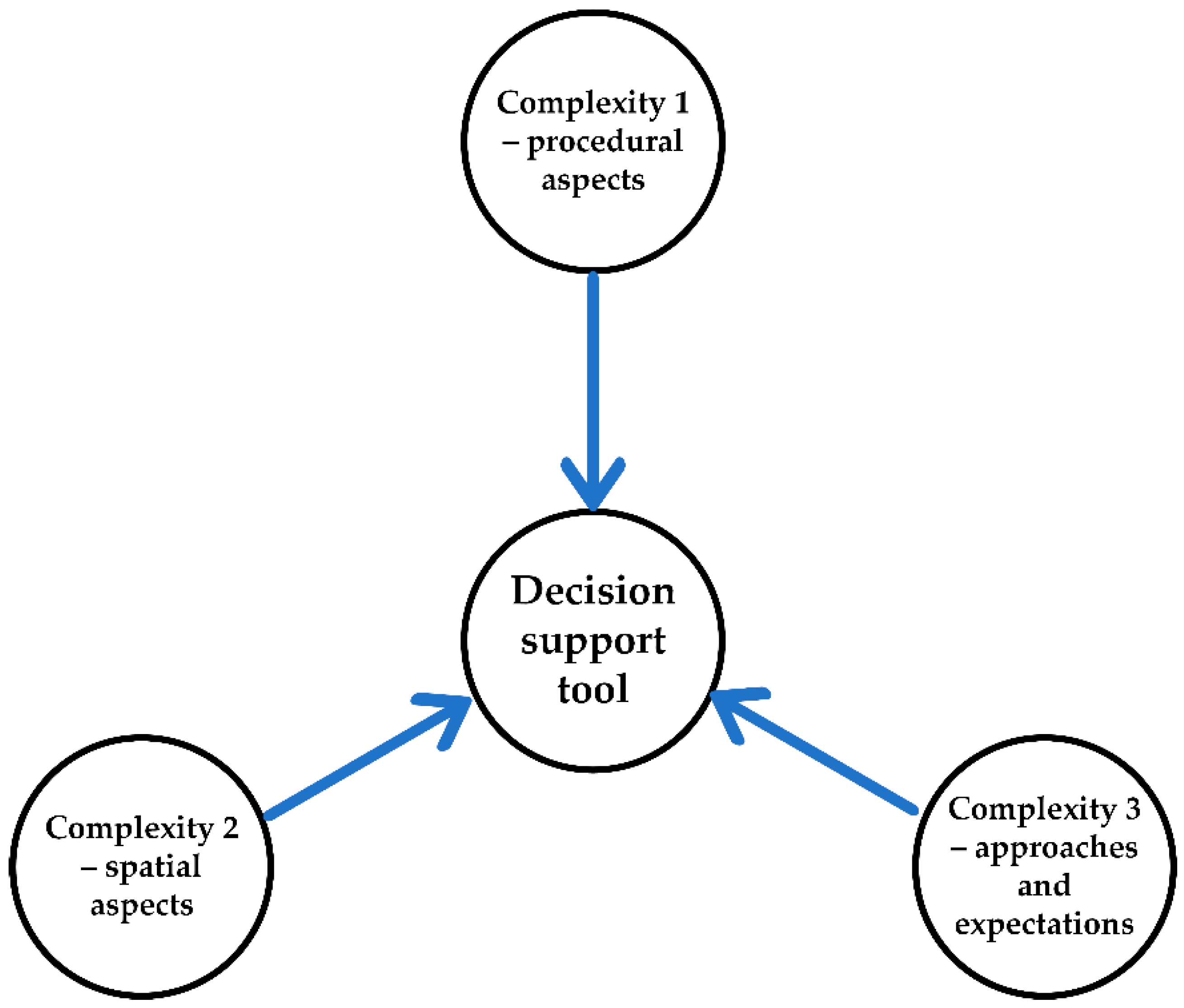
Because these concepts relate to many fields and are the topic of different research and practices, it is not possible to give a detailed literature review of every topic, but the goal of the literature review is to give a holistic overview of the characteristic issues and insight on the importance of those concept groups in contemporary spatial planning and development, their relation and the mutual influence on spatial development, as well as to identify the opportunities for a comprehensive model that could be decision support (as in Figure 1) during described processes in sustainable development and resilience perspective.
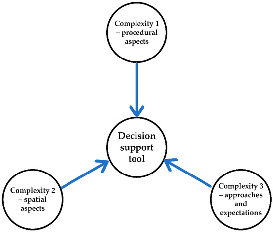
Figure 1.
Conceptual framework for a decision support tool in spatial planning in relation to holistic approach to the 3 complexities.
2.1. Complexity 1—Process of Spatial Planning and Its Problems
Spatial planning, even if it has its roots in antiquity, develops greatly after the 1st and the 2nd World Wars. The second part of the 20th century has seen at first a development of spatial planning and optimism in its capabilities, and then its crisis that lasts for almost 50 years. The factors negatively influencing spatial properties are related to the dimension of spatial planning [10].
After WW2, the comprehensive or systemic approach was developed, which viewed space and its development in a comprehensive way, based on sciences [11,12]. Since the 1960s, there has been increasing interest in social aspects of planning, with increasing fragmentation of topics.
There are several problems with the activity or process of spatial planning itself. In the diagrams [11,12] that show the ideal situations of various types of spatial planning processes (here defined as ideal situation: I.S.), it can be noted that there is a lack of an analytical phase before the decision on starting planning activity (in the I.S., just as in reality)—whereas this decision probably influences the planning process from the beginning. The analysis (in the I.S.) starts after the decision on planning process followed by forming the spatial planning goals. In reality, the goals are formed before the decision on planning, which can be expected will interfere with the process, because the whole process (from analysis to proposals) is done after the goal definition and the planners are not yet involved. In the next phase of the I.S., the scenarios are defined, analyzed, and evaluated, possibly in a long-term vision. This phase is also, in reality, often skipped. Then the plan is adopted, and the next phase is its implementation. Therefore, there is a problem with the planning phases even in the I.S., and it is even more complicated in reality when decision-makers and planners are in different spheres. This division also presents interesting questions on the positioning of evaluation professional(s) as members of a planning team or a decision-maker team.
All the phases include value-based decisions, even if ideally there are no conflicts in values allowing the process to be considered as the technical activity of the planning team and decision-maker that have similar values, just as the stakeholders and the public. In reality, this is not so [13], and since the mid-20th century, many different branches of spatial planning theories and approaches were created that are mostly relate to social aspects of spatial planning, as well as the social creation of values [14] and communication. In these approaches, the planner becomes more of a social activist that engages themselves at the side of vulnerable groups [15], even if they are paid by the decision-maker—which is not a sustainable position, especially as there is a lack of a neutral figure as in judiciary system [15]. This leads to a group of liberal and neoliberal spatial planning approaches that are less optimistic [11], and oriented to planning for elite and tourism [16]. Various theories consider the relationship between capital and planning (or planner), but do not mention the importance of politics, state and other powerful stakeholders that have political power without direct capital movement. Only more recently, generally when considering the planning processes in South (meaning non-USA and western Europe, termed here as “North”) the research starts to notice the decisive role of politics and politicians [17].
The second development is oriented to communication and co-creation aspects, often not considering the problems such as differences in power inside and between groups, conflicting values and interests [13,18,19], prejudices, or difficulties that some citizens have in participating [20]. Some authors [21,22,23] note that public participation requires a stable society with the tradition of participation. Also, none of the researched sources mentions potential lack of knowledge in some field, which can be interpreted in many ways: as optimism of equal knowledge, giving up on the scientific and professional knowledge and role (noted also by [15,24]), the maintenance of the professional planner role as it is, although it is not mentioned directly; and which would imply the maintenance of the general structure of the modern planning process. It can be noted that those approaches cannot be used exclusively in complex environments with different stakeholders with different needs, values, and powers.
Since the 1970s, planning is oriented towards post-positivistic and post-modern approaches, as it is understood that it is based on values and politics. Fragmentation of approaches and distancing from general planning theories, can be directly connected to post-modern distance from unified scientific knowledge [11], also reflected in the related field of architecture [25].
Recent developments are related to practice-based theories (based on different types of case studies [26]). Some negative aspects seem to be: lack of application of theories in practice, circulation of existing ideas without new knowledge creation, exchange of the scientific and professional knowledge with public knowledge [17]. It also raises concerns about the influence of planning theories, as the theories and methodologies should be general and atopical [27]. In some countries the innovations arrive from different branches of state and not from civil society [17]. The inadequacy of Northern developmental models is being criticized in scientific literature [28,29,30]. The crises of spatial planning and development is noticed even in North, with recent strong orientation to sectoral policies [31].
Strategic planning often refers to top levels of planning, as regarding the definition of goals in top-down approach, but in neoliberal spatial planning it is often related to the solution of some aspect or area deemed as problematic or in need of development. It gives more general indications and goals and is not detail oriented [16]. Positive results are noted by [32] where, areas for strategic planning were defined by spatial and requirements characteristics. Similar orientation is noted by [33]. Strategic planning and management model for HUL based on economic evaluation and stakeholder participation is discussed in [34]. According to [35], strategic planning since the 1990s is oriented to intervene with quick continuous changes in European territories related to changes in capitalistic systems. Landscape urbanism is lately gaining importance, especially in the North [36]. It can have various meanings and is characterized by complexity and indeterminacy [37]. It can be related to landscape architecture, to design and planning aspects. It is synthetic, evolutive process, multi-scale, locally related [38]. It is often related to urban interventions in shrinking cities [39] and its void spaces [40]. Usually, it relates to interventions without important buildings, but sometimes it can also incorporate big infrastructure [39].
Another interesting aspect in planning is the role of the evaluation and prioritization of alternative scenarios. They develop from operational research, mostly after the WWII [41]. Modelling of scenarios and predictions in spatial planning is more complex than those sectorial. Evaluation is considered to be a part of the spatial planning process, but it is rarely done in the reality of planning practice, and is mostly done for the economic sphere [42]. The importance of evaluation as a part of the planning process gains importance with public participation.
The “lack of support from urban planners” regarding Urban Green Infrastructure in spatial plans is noted by [43]. The observation indicates the problem of decision-making in spatial planning: the planner does not decide or implement innovative approaches for which they have no approval from the decision-maker. On the other hand, [44] reports small percentage of planners and architects (8%, 24%) that use security strategies in their designs, but the connection with standard practice is not clear. Spatial planning is considered as “a promising instrument to reduce flood impacts” by [45]. It shows the lack of sectorial connection within spatial planning, due to lack of access or obligation of information use, and lower understanding by the general and professional public [45]. The importance of spatial planning for flood prevention through zoning, is considered by [46], while [47] considers it as a platform through which conflicting interests can reach agreements. This indicates the need for improvement of the integration of sectoral policies in spatial planning, as this is the area of human activities that considers the coordination of human activities in their spatial aspect, especially on local levels [48]. The possible integration structure is proposed and discussed in [49].
Table 1 presents the most salient points of complexities in spatial planning and decision-making process, and the opportunities and requirements of a potential decision-aid model.

Table 1.
Complexities 1, opportunities and requirements of a decision-aid model related to complexities in spatial planning.
2.2. Complexity 2—Complex Context
The urbanization process has its apex in the last 50 years [50]. Some areas, especially urban, are complex environments created by stratification of hard and soft activities during their long history [51,52,53]. This spatial heritage—natural and build, production and activities, is as all heritage, a social continuous process based on values and regards elements of the past but also our vision of today and the future [2]. The continuity implicit in the presence of heritage gives it major importance in the transformation of places where people live, and the potential loss of its Complex Social Value [54] can produce social trauma [55,56].
These complex environments can influence the quality and life, self-identity, and self-perception of the population [57,58]. The territory can be interpreted as a widespread good [52,59] that can mostly positively impact the life for local residents, and secondarily tourism [60]. This complexity was internationally recognized first by [61] (2000, amended in 2016) that acknowledges all territory—both extraordinary and ordinary, urban, rural, and natural as landscape, to plan and manage in “landscape quality objective”. At the global level complexity of the territory was acknowledged by [6] introducing the concept of HUL. It recognizes the spatial stratification of heritage, notices the rapid urbanization with subsequent environmental and social problems, and states that the HUL is comprised both by natural and artificial components, in both tangible and intangible aspects, and should be managed from a sustainable development perspective.
Cultural significance impacts social values, and is often embedded in the territory with complex historic spatial stratification [62]. The complexity of heritage is discussed by [2,9,57,63,64]. With the awareness of negative aspects related to sprawl, scattering [65,66], and peri-urban development [30,67], there is a growing interest to use already used land so not to use additional rural or natural land [5] as well as to connect fractured spaces. Those areas face demographic, structural and environmental problems even if they are still inhabited [68]. Some EU countries have the state authority for the requalification of strategic areas [69]. Urban voids, especially smaller can represent the opportunity for creation of a network of informal spaces [70]. Urban voids are usually smaller unused urban spaces, but their most characterizing aspect is the lack of function [71]. The opportunities of identification and use are discussed in [71]. They are usually not destined to building development (and are approached as possible landscapes). This shows an enormous shift in understanding of open spaces and the relation of built and unbuilt areas, which is discussed in [72] and is in line with other contemporary critics of modern creation of space discussed in [73]. Urban morphology or urban texture can be the most significant element of spatial identity [28,74], and its modification can influence positively or negatively both the identity of local community and climate, or even rates of criminality [75,76,77].
Traditional urban structures were the result of emergence and generative processes that could be used in contemporary intervention planning, for example using principle-based codes [78,79] (in a similar pattern approach as to [80,81]) to maintain the gradual change (differing from modern tradition). A similar continuation, but of forms and not of principles, is discussed in [82].
Table 2 presents the most salient points of complexities in considering the spatial context, and the opportunities and requirements of a decision-aid model.

Table 2.
Complexities 2, opportunities and requirements of a decision-aid model, related to complexities in considering the spatial context.
2.3. Complexity 3—Complex Requirements—Resilience and UN SDGs
Modern planning, as developed in the 19th century, was mostly related to real estate characteristics and values, and had a social and class component, as the first zoning principles were related to maintenance of property values [21,83]. Modern planning in in the 20th century was oriented mostly to monozoning planning [84], which simplifies the planning approach treating the territory as empty space [85], often resulting in great demolitions [86]. It helped to maintain the quality of life of middle and high economic and social classes and often kept the lower economic classes excluded from urban development (especially in the South) [16]. Big problems of the cities today are urban sprawl and scattering, growing poverty, weak governance and environmental policies, inequalities, and exclusion, often overlapping in the same place [13,16,28,74], especially in South, but even in the North [87].
The concept of development is more used in South [21], introduced with modern planning. It passes several crises with focusing first on the market and later on the topic of governance. In the sustainable development, the topic of urban environment has a central place as a space of modernization [21], quality of life [88], and then as a spatial configuration of human environment that can, curb the expansion of built environment [5] and be more energy efficient. On the other hand, the same urban environments can produce other problems such as great use of resources [21] and difficulty in introducing Green Urban Infrastructure [43].
The notion of “sustainable development” or “durable development” started with [89] and gained more interest with [90]. It is generally defined through 3 spheres (ecological, economic, and social) [1,54,91]. With [1] the aspects of sustainable developments are defined through 17 goals, each with specific sub-goals (169 in total). Their orientation to international and national policy levels [92] makes them require detailed elaboration in spatial and technological terms for local or detailed level of planning (or design) but less expansive if used for strategic planning. The “sustainable and resilient path” is given as a direction toward the achievement of sustainable development [1].
As the goals are “people-centered goals” [1], they are elaborated with strong social emphasis even when covering natural environment. Only some sub-goals (oriented to ecosystems) can be interpreted as more protective than management-oriented. The goals cover challenges of poverty, health, inequalities, ecological management, urban and rural development, use and protection of resources, resilience to natural disasters, financial aspects and partnerships. The document [93] follows international documents on disaster risk reduction. It shows the emphasis (not complete shift) on disaster risk management instead of disaster management. Risk reduction, new risk prevention, existing risk reduction and resilience [94,95] strengthening are the main points of interest of the risk reduction strategies [96].
The contemporary approach to spatial planning tries to requalify the places that are exposed to risks using adaptation strategies, as to allow for reuse of already urbanized spaces and the control of urban expansion [5]. A resilient place can maintain function while absorbing shock, but also maintains capacity to renew and reorganize to keep functioning, especially in awareness that there are both known and unknown threats [97]. As resilience, so spatial planning and decision-making for resilience must be multiscale and multidimensional [98]. Aspects of resilience and its spheres that should be considered in spatial planning are given by [99,100]. This approach is based on anticipation, planning and reduction of disaster risks, working on “risk drivers” (poverty, lack of planning, and governance), and is people-centered and preventive, multi-hazard, multisectoral, and oriented toward resilient reconstruction [93].
Sustainability and resilience make the approach to spatial planning increasingly complex, introducing or giving more weight to the “new accents”, topics that are gaining increasing importance, whether relatively new (climate adaptation) or not (green infrastructure) [94]. Different human environments impact the health in different ways, specially of poor population that is even more vulnerable than rural population [50].
Accessibility can be interpreted in two main ways. One is related to barrier free spaces [20,101] and is a basis for Universal Design [102]. The other is related to the urban infrastructure and places and their topo-geographical position that allows for access, related to mobility in general. Walkability [103,104] regards the ease and attractiveness of places for pedestrians [105]. It does not cover accessibility (as accessibility considers partially different concepts and requires even more detailed analysis and design). Smart mobility is gaining importance, and regards new vehicular technologies, communications, way of life, and micromobility [106]. Different elements of public infrastructure can impact the possibility and ease of use for the persons with disabilities [107].
Public spaces have great importance in public life, particularly related to freedom and expression, and generally in the way of life of local population, and there is raising interest on the impact of climate change on them [108]. Urban Green Infrastructure is important for various ecoservices and maintenance of biodiversity [43,109], as they have positive effects on CO2, Urban Heat Islands, flood mitigation [43], or stormwater harvesting, and can supplement traditional water drainage [110].
Smart Cities are considered to be developed through six pillars related to nature, living, mobility, governance, people, economy [111]. In Smart Cities, monitoring the effects of everyday activities and natural events, is aided by sensors, remote sensing, and big data. This would allow for monitoring of environmental and human factors that could allow for predictions and interventions in case of extreme events, and would, in the future, allow for 3D planning system [112]. Monitoring of quantitative indicators can help with decision-making about the renewal or sectoral decisions. “Digital urban space” (a digital twin of urban space) is proposed by [113], from the connection of various technologies [111]. The continuous data collecting and analyzing, raise the question of privacy, but could be useful for spaces related to the public sector. The basis for urban spatial monitoring and digitalization exists as Spatial information infrastructure in more than 100 countries [45] and could be reinforced with remote sensing [114].
The behaviors of all systems that are a part of climate change are not completely understood therefore the comprehensive modelling of climate change impact is not yet completely possible [115] and is especially difficult in spatial planning where the changes are impacted by many factors most of which have different dynamics. There are both increasing risks [46] and risk awareness about possible impacts of climate change [116], such as sea and river level raising, rivers drying-up, extreme weather, etc. The traditional approach to risk mitigation was related to physical spatial infrastructure and risk economy [117], that is now recognized as a partial approach. Existing infrastructure could be inefficient due to lack of maintenance or designed based on old data [46]. Additional problems are related to the lack of understanding of risks from the general public that makes it harder to invest in adequate infrastructure (even in North [45]), and is also related to the partial loss of infrastructure during the modern period [5]. Today, the preference is for approaches that combine the creation (or maintenance) of risk mitigating infrastructure and softer approaches [46] (defining levels and uses of accepted flooding) and allowing for continuous functioning of selected areas with most frequent “soft” measures [45].
The counterterrorism and counter-crime measures also tend to be twofold—through infrastructure (specially “landscaped security”) and governance [44]. Urban spatial functional organization is required to be fragmentable and usable independently, in 15-min logic, especially in case of emergencies [118]. Similarly, as with environmental risks, the public, even professional, are often not aware of risks and can pose resistance to the use of security-based design [44].
Urban Heat Islands are particularly important in dense areas, but [47] reports that the impact of urban form depends also on location. The overview of the impacts of pavement surfaces is given by [119,120,121]. Various types of architecture and urban forms [122] can also help the adaptation to climate changes and research into the traditional forms can also be helpful [123,124]. Tourism is an important part of the economy, but it can also produce negative effects on spatial resources [28,125,126,127,128]. Tourism planning is directly related to spatial planning, but is increasingly based on economic approaches [129]. The human environment is a part of general environment and takes part in exchange circles of resources and energy. Circular organization in the cities shows benefits that depend on the type of circularity, suggesting that different circularities should be implemented together. Gentrification can be a result of improvement investments, in fact inadequate intervention can produce social polarization and durable lack of sustainability [130,131].
Table 3 presents the most salient points of complexities in approaches and expectations (“new accents”) in spatial planning, and the opportunities and requirements of a decision-aid model.

Table 3.
Complexities 3, opportunities and requirements of a decision-aid model, related to complexities in considering the spatial context.
3. Materials and Methods
3.1. Development of the SPUR Model
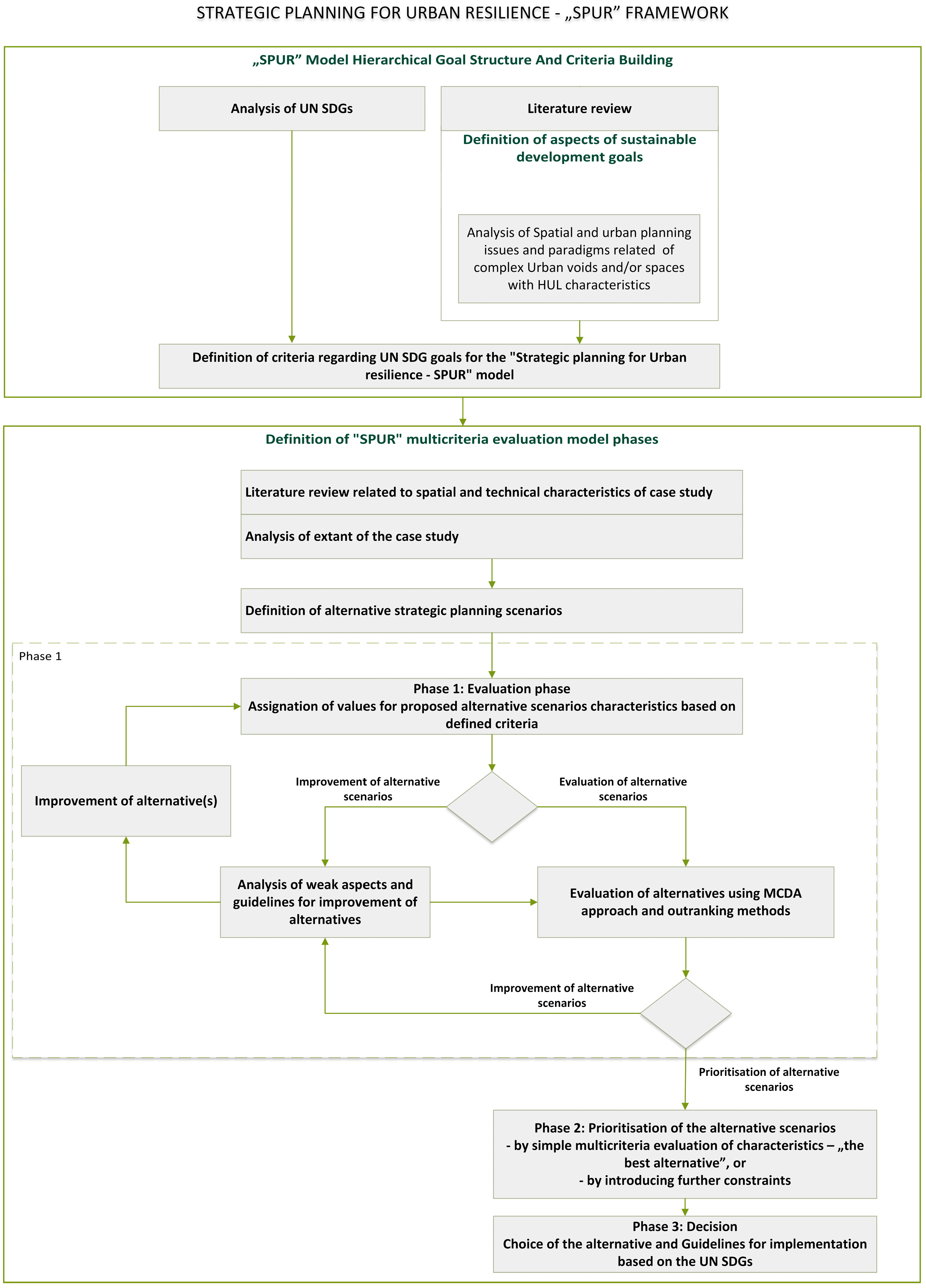
After the research questions had been asked, the work phases and workflow were defined, resulting in a holistic Strategic Planning for Urban Resilience, i.e., the SPUR model (Figure 2). The model consists of two major parts focusing on establishing a hierarchical goal structure and conducting multi-criteria decision analysis.
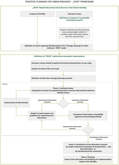
Figure 2.
Strategic Planning for Urban Resilience—SPUR model.
Therefore, the 1st part considered a literature review through which the connections of spatial planning, UN SDGs, and planning for the complexity of urban territory were investigated, as well as useful concepts that today have growing importance for spatial and urban planning. This part was helped by the network analysis using “visualization of similarities” software [132] VOSviewer (Nees Jan van Eck and Ludo Waltman, Leiden University’s Centre for Science and Technology Studies (CWTS), Leiden, The Netherlands) [133] and the retrieval of bibliographic data based on keyword research. The literature review was done using standard internet research based on proposed keywords and the search query, as shown in Table 4. The search query was used in both Scopus and Web of Science (WoS) databases.

Table 4.
The search query used in both Scopus and WoS databases.
The research mainly found papers that are at least partially interdisciplinary, sometimes overlapping key topics and other times expanding them. Based on the conducted literature analysis and analysis of UN SDGs, the UN SDGs goals were further defined into criteria that could be used to evaluate scenarios. This was based on the approach described in [90], where spatial planning experts interpreted the UN SDGs to express further the spatial and technical aspects of Mediterranean area characteristics that are not evident in UN SDGs. In this research, the UN SDGs were refined based on spatial and technical aspects of urban voids and HUL areas and the “new accents” planning issues described in the previous literature review section.
After this first step, two further iterations were done. In the 1st iteration, it was noted that some criteria related to different UN SDGs were identical. In this case, only one was chosen and assigned to the SDG with which it seemed more in line or to the SDG that had fewer criteria. At this stage, some criteria were deemed to be more appropriate for the lower level or next stage of urban planning, such as urban design, as they were related to a more detailed planning scale. These criteria were delegated to the holistic implementation Guidelines for lower levels of spatial planning, urban and building design (further explained below). In the 2nd iteration, some criteria that complemented each other were connected to form a unique criterion which was also assigned to one UN SDG based on the already mentioned criteria. At the end of this process, there were 49 criteria (Table 5) that were then used to evaluate the alternative scenarios holistically.

Table 5.
The SPUR model hierarchical goal structure.
Because the UN SDGs are also defined through sub-goals, and criteria were often related to these sub-goals, on some occasions, the criteria can sometimes appear somewhat disconnected from the UN SDG. For example, in the case of UN SDG1, where the sub-goal of the goal “End poverty in all its forms everywhere” was: “By 2030, build the resilience of the poor and those in vulnerable situations and reduce their exposure and vulnerability to climate-related extreme events and other economic, social and environmental shocks and disasters” [1] and then influenced the criteria building.
The SPUR model is organized into 3 phases (Figure 2): evaluation phase, prioritization phase, and decision phase. The base for the prioritization and evaluation was PROMETHEE methods [134,135,136,137] and VisualPROMETHEE software [138], which offers several evaluation scales. Most criteria were evaluated with the Qualitative 5-point scale, with function direction toward maximum or the best grade for the best situation. Some criteria were evaluated based on the Impact 5-point scale, and only some were Numerical with minimum and maximum values and point of deflection (the value at which the alternative changes from positive to negative). The expert evaluators (spatial planning experts) were familiar with these scales when assigning the values to the alternatives based on defined criteria.
Often, the development of a hierarchical goal structure (HGS) is the first and crucial step in the decision-making process. It is an iterative process that ends when all stakeholders agree [83,139,140] and can be defined from a pool of experts involved in particular problem-solving [83,139,140,141] or as a part of a defined decision support concept [139,142,143,144,145,146]. In this case, our group of experts provided one final HGS with all criteria weighted equally. Such is used to establish the soundness of each alternative concerning the stated HGS. Therefore, the newly developed and proposed SPUR model seeks single-stakeholder, i.e., expert group, and equal criteria weights rather than multi-stakeholder and different criteria weights. The reason lies in the stated research questions of this approach, and it seems to return valid answers, at the same time, offers a solid measure towards which the variability of the weights could be tested and validated. Therefore, the multi-stakeholder approach, which previously showed promising results [83,92,139,140,141,142,143,144,145,146], would benefit the proposed SPUR model’s future research and maturity buildup.
The phase 1, evaluation phase has several aspects or sub-routines. First, potential alternative scenarios are evaluated with respect to the criteria and using proposed evaluation scales. This opens 2 possible directions. One sub-routine (Improvement of alternative scenarios) allows the verification of weaker aspects of the alternatives, and gives holistic guidelines for improvement (on a strategic level), then the alternative can be improved and reevaluated again. This sub-routine can be used when it is required that all compared alternatives are at least “good” (or other chosen value) in all or chosen criteria before being taken in consideration for the choice of alternatives. On the other hand, also the alternatives that are not “good” can be evaluated, but the assignment of values to the alternatives based on criteria, makes this aspect communicable. This sub-routine is aided by the coding of cells formula and format in Excel (but other similar software can be used as well). The extract of this stage is shown in Appendix A, Figure A1.
The other sub-routine evaluates the alternatives using a multi-criteria decision analysis (MCDA) approach based, in this case, on outranking method. Here the PROMETHEE method and the aforementioned software were used. Other MCDA methods could be potentially used, but when dealing with a large number of qualitative and quantitative criteria, the PROMETHEE methods show superior strengths. Here, the PROMETHEE II method [135,136,137] is used to obtain a complete range of alternatives, followed by the PROMETHEE Network and PROMETHEE Diamond for verification and validation. For both aspects, the VisualPROMETHEE software [138] is used. After this phase, the alternatives can still be improved, and the process is repeated.
In phase 2, the alternative scenarios are compared. It can be done in several ways. The simplest is a simple comparison based on the evaluation—“choice of the best alternative”, but it is also possible to introduce constraints such as budget, different weights for the criteria etc. The phase 3 has two aspects. Based on phase 2, in phase 3, the decision can be made by a decision-maker. Also, this phase gives the holistic Guidelines for implementation (guidelines for the next stage of planning at a more detailed scale, given in Appendix B) based on the “new accents” in spatial planning described in the literature review.
After the literature review and creation of the “Strategic planning for Urban Resilience—SPUR” model, the model was tested on the case study of the Delta area in the City of Rijeka, Croatia.
3.2. Case Study—Evaluation of Alternative Strategic Spatial Planning Proposals
3.2.1. Area of Study—Delta Area, Rijeka
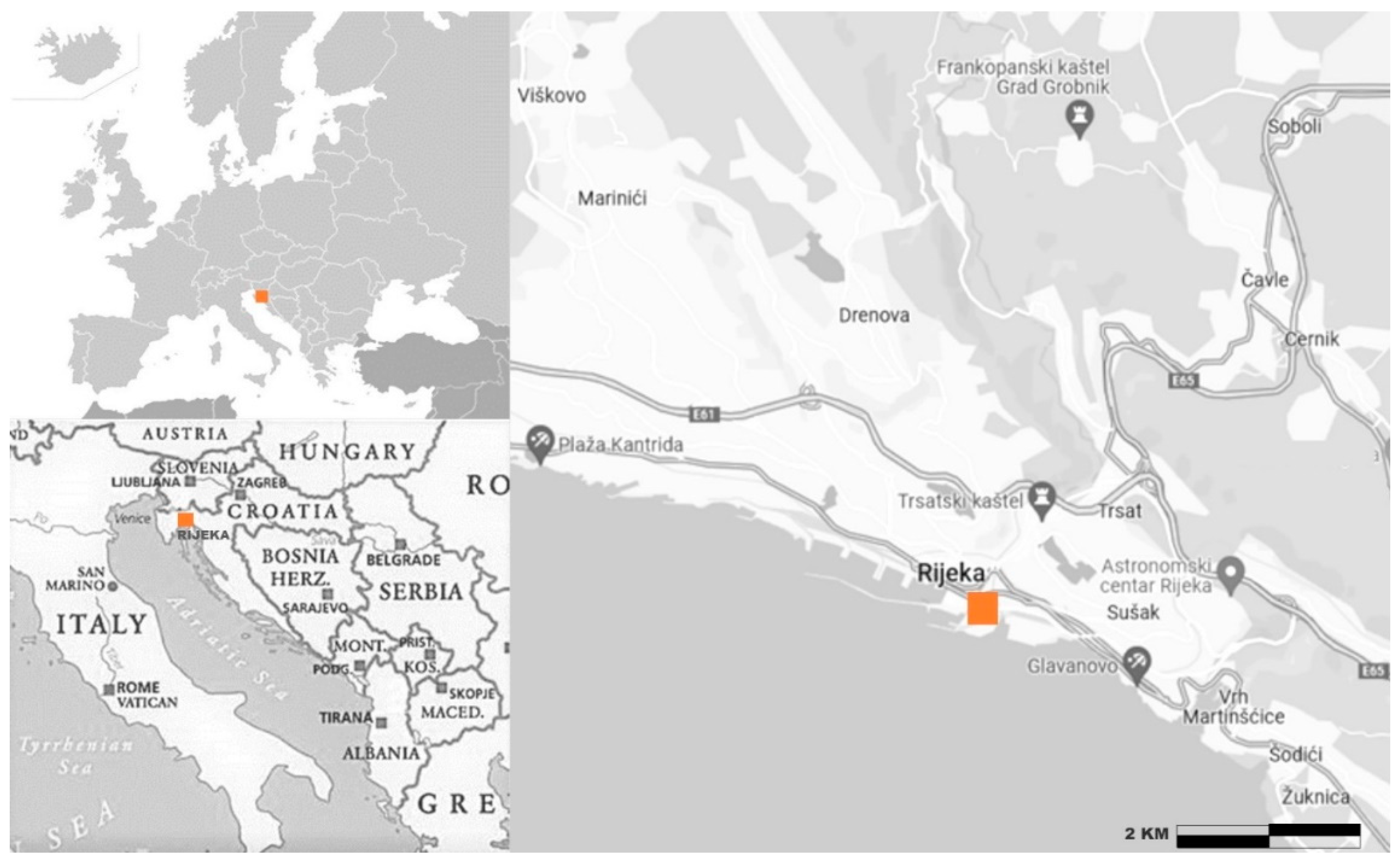
City of Rijeka, “continental face of on the mirror of Mediterranean”, situated in Kvarner Gulf, is the biggest Croatian port [147,148], 3rd biggest city in the Republic of Croatia, and regional capital of Primorsko-Goranska County, with 266.503 inhabitants [149]. It is a northern nodal point on the Adriatic coast that connects the Adriatic coast and Pannonian Basin (Figure 3). Crucial events for the city’s growth happened in 1717 with the declaration of free navigation in the Adriatic by Habsburg emperor Charles VI, in 1719 when Rijeka, together with Trieste, got the status of free port and in 1852 when the city river Rječina channel was regulated after the flooding, and a new river channel. The previous river basin become a port, and urban element known as Mrtvi kanal (Dead channel). These two elements define the area of the case-study.
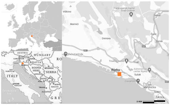
Figure 3.
Upper left corner—the position of City of Rijeka regarding European and Asian continents, lower left corner—the position of City of Rijeka with regards to Republic of Croatia and neighboring countries, right—the position of Delta area in City of Rijeka.
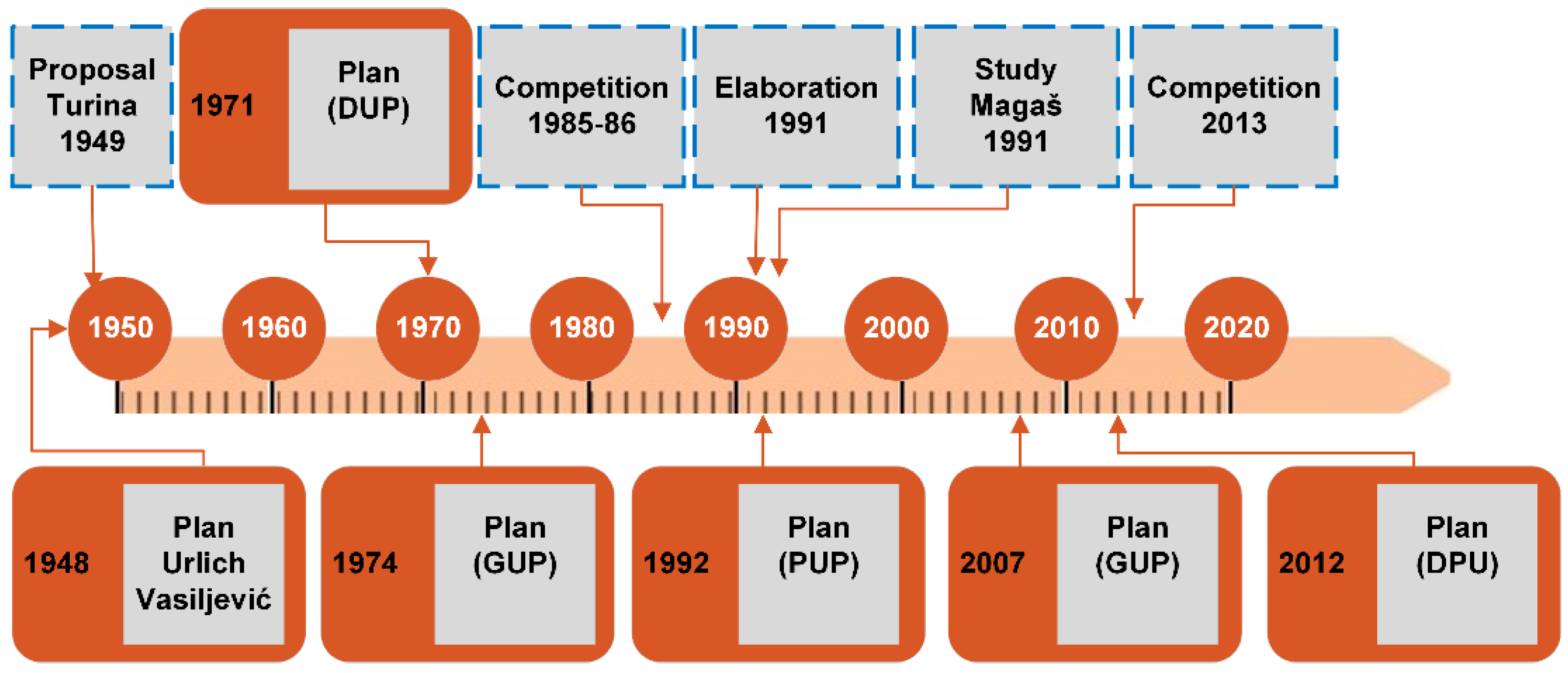
The construction and expansion of the port engaged international stakeholders, and the city port in the 19th century developed one of the biggest ports in Europe and an important industrial center [49]. This was aided by railway and road constructions. Construction of Delta was mostly done in this period (1888), and the port activities grew quickly until WWI [150]. After WWI, the Delta area was in a bordering zone of two different states, dividing the city in 2 different cities (Rijeka and Sušak), while the port was divided (although partially expanded). Port infrastructure was partially added as well as some of the warehouses and administration buildings, that represent important cultural heritage. After WWII, the value of Delta area in urban design and its role in the connection of the previously divided city was emphasized. The regulation plan from 1948 defines the Delta area as a part of city center that connects the city by representative (mostly administrative) buildings, and gives the regulation of green and public areas. It also defines the port, railway and road expansion, the connection of the two cities in one urban unit, connection of the city and its surrounding and the sea, city expansion, green areas, tourism, and public use buildings [151]. The Delta area would therefore allow for the creation of the center and contact with the sea. This is still not realized. In 1949 Turina, V. (with Radić, Kučan and Seifert) [152], proposed a recreational zone with an iconic swimming pool.
Between 1951 and 1960 Rijeka was the most important port of ex-Yugoslavia. This, among others, results with the construction of Exportdrvo building on Mrtvi kanal and attached industrial infrastructure. With the plan of 1974, the Northern part of Delta was planned as a part of the city center, while the Southern part remained as port, with the area divided by the new road D-404. In 1985–1986, an urbanistic and architectural design competition was organized. In 2013, Port authority and City of Rijeka organized an urbanistic and architectural design competition. Currently, those designs are not realized. They are all mentioned in Figure 4.
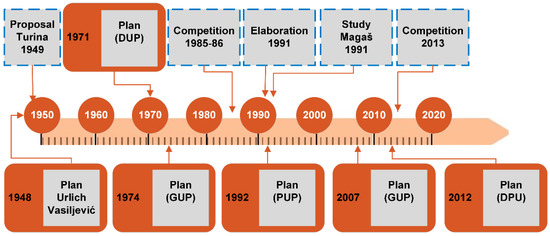
Figure 4.
Main planning and design proposals for the area, based on [153,154,155].
The area in consideration can be considered as HUL as it is a result of historic layering of cultural and natural values. The area is mostly manmade by adding terrain to a natural coastal area in multiple moments of history and is defined by the manmade river bed and a channel that was previously a city river. The area has a sea side.
The built elements represent important city infrastructure that historically connected or divided the city, based on historical circumstances. The main functional aspects of the area, mostly related to portual activity, gave this area characteristic mostly void or partially built character throughout the history. It was and is a place of important views (perceptions and spatial relationships) towards historic landscape of both former cities, of two historic nucleus between them (as it is void), river canyon with its forest and main landmarks (castle of prehistoric founding and internationally important sanctuary) on the city hills, urban structure that connects low areas of the city with the center on the hill together with its historic monuments, both historic and new ports and the sea. Small urban green and tree-lined river and channel beds are historical spatial places that play an important part in defining urban character and identity. The channel was until recently a place of trade, and is still a place where local population has the small boats, and is one of the main connectivity points in urban mobility, that was also a part of the first urban public transport routes, and is an important place in urban pedestrian network that connects areas of the two former cities.
3.2.2. Alternative Scenario Proposals
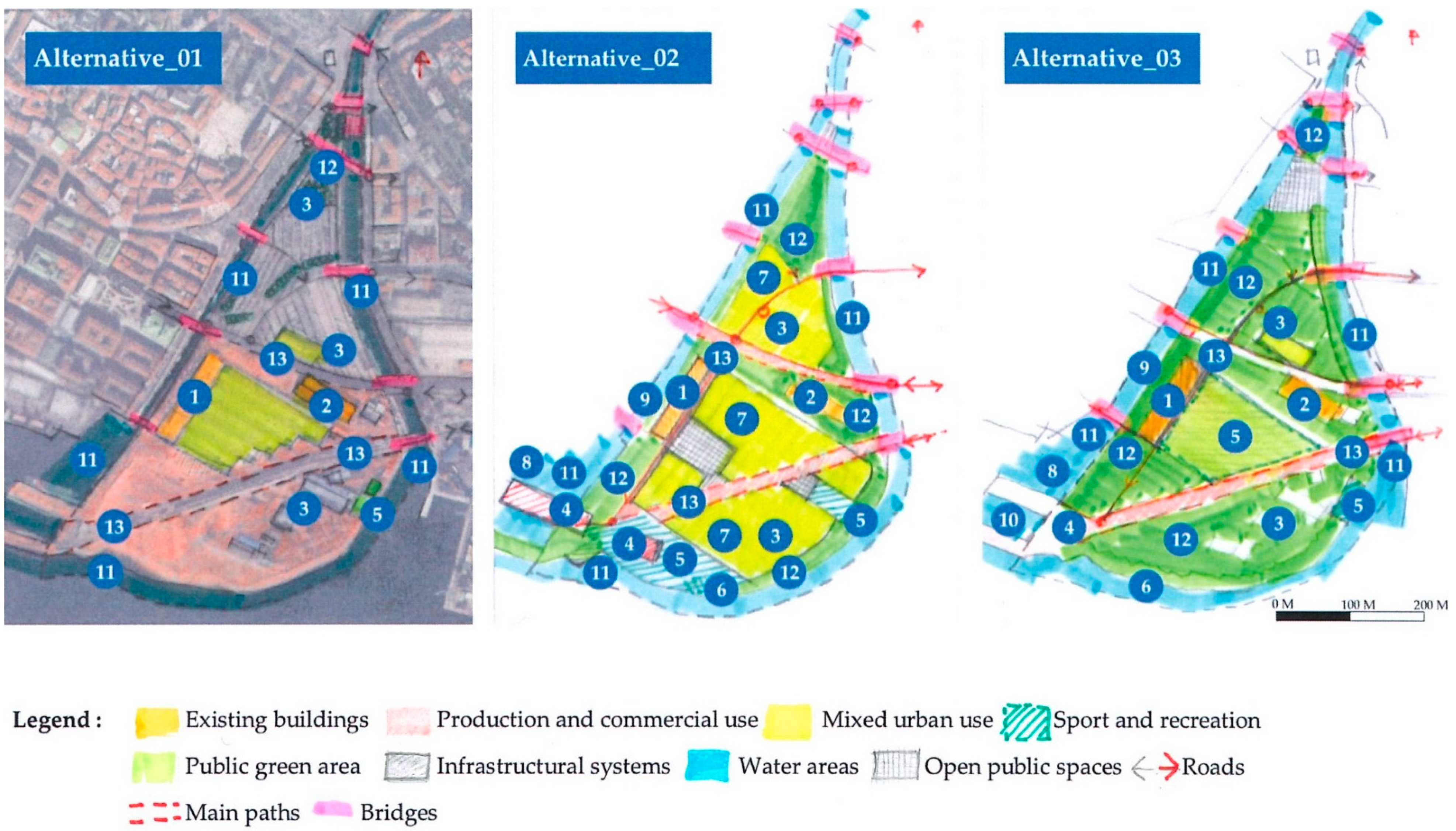
Three alternative scenarios for Delta area were proposed and evaluated (Figure 5). The area is connected with the rest of the city by ten different bridges. Today, it is mostly used as parking space and infrastructure for autobus and port, with some zone of communal infrastructure, a small sport club and administration and temporary cultural space. There are some potential problems related to the possibilities of flooding. Alternative scenarios 2 and 3 are both proposed based on three levels of complexity, HUL and landscape based urban planning, and sustainability principle for resilient landscape.
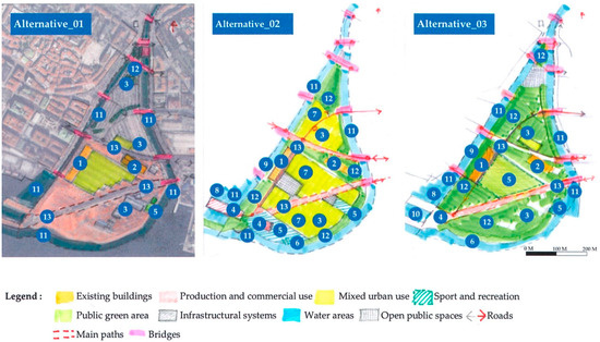
Figure 5.
Alternative scenarios: 1—public use, 2—business area, 3—communal services, 4—business, commercial and tourism, 5—sport and recreation, 6—sport and recreation—swimming area, 7—mixed use, 8—nautical tourism port, 9—sports port, 10—fishing port, 11—water areas, 12—green areas, 13—infrastructure.
Alternative scenario 1 is a “do nothing” scenario. There is a noticeable lack of green areas with subsequent lack of ecological network. The northern part is in minor part used as memorial area with the monument, touristic activity, passive recreation, and small green area, while the most of this area is used as city parking. The southern part is mostly industrial and infrastructural with railway infrastructure, heliport, and in a smaller part city water purification plant and Rowing club. The ex-industrial buildings are now used for administration and temporary cultural events.
Alternative scenario 2 is based on partial continuation of present city structure, characterized by urban blocks and mixed use (commercial, administrative, residential, touristic, public, cultural). Existing water purification plant, Rowing club and heliport are maintained. The rest is used for green and recreational area that are now lacking in the city. The green areas create continuous network with existing green areas and corridors outside the area and they also defined river, channel, and sea waterfronts with pedestrian paths, opening the contact with the sea. The level of the terrain is raised, and buildings have water recycling and reuse, as well as above average energy efficiency.
Alternative scenario 3 is mostly based on resilience strengthening. In south, the nautical tourism, sports, and fishing ports are proposed, as well as touristic, recreational, and swimming. The contact with the sea is also formed. Existing water purification plant, Rowing club and heliport are maintained. Proposed interventions include various resilience interventions: terrain raising, protected communication and safe places and shelters, flood and earthquake resistant construction, green infrastructure, water recycling and energy efficiency, etc. This alternative relates to the city identity as a city on sea and river, especially in the central urban part. It also creates less spatial conflicts and allows for renaturalization of coastal areas.
Alternative scenario 1 as a “do nothing” scenario different than the other two alternatives, as the other two alternatives are prepositive of improvement. “Do nothing” option is characterized by the closure of the case-study are for the public as it contains mostly inaccessible communal infrastructure.
Alternative scenario 2 and 3 are similar in the fact that they are proposing requalification of the area. Scenario 2 is based on a presence of a denser construction of commercial and residential buildings, while scenario 3 is oriented to public spaces and uses such as recreation and green spaces. Both scenarios propose the requalification on the bases of sustainable principles and involve opening the case study area for public (in different measure) and towards the sea, with the largest dedicated area appearing in scenario 3.
4. Results and Discussion
Once the clear hierarchical goal structure (HGS) is defined, the prerequisites for conducting the SPUR multi-criteria evaluation model are set. In this particular case, as previously argued, the decision-maker has a fixed HGS to evaluate alternatives in relation to different criteria. This allows them to freely select experts for alternative evaluation as well as decision analysist for conducting the multi-criteria evaluation. It should be highlighted that the evaluation of alternatives is done according to previously stated sustainable criteria (Table 5) that results from the first step of the SPUR model and creating a decision matrix (Appendix A, Figure A2). This can be done by a single stakeholder or by multi-stakeholder, the model is opened to such and gives opportunity to decision-maker to come up with a compromised point of view of all involved stakeholders into a clear and concise HGS.
In the second step of the SPUR model, the focus is on a multi-criteria decision analysis of Delta’s alternative strategic planning scenarios. This is conducted throughout three phases: evaluation, prioritization, and decision phase. As previously stated, this step is supported by multi-criteria decision-making methods, particularly the PROMETHEE methods (PROMETHEE I and II in particular) employing VisualPROMETHEE software.
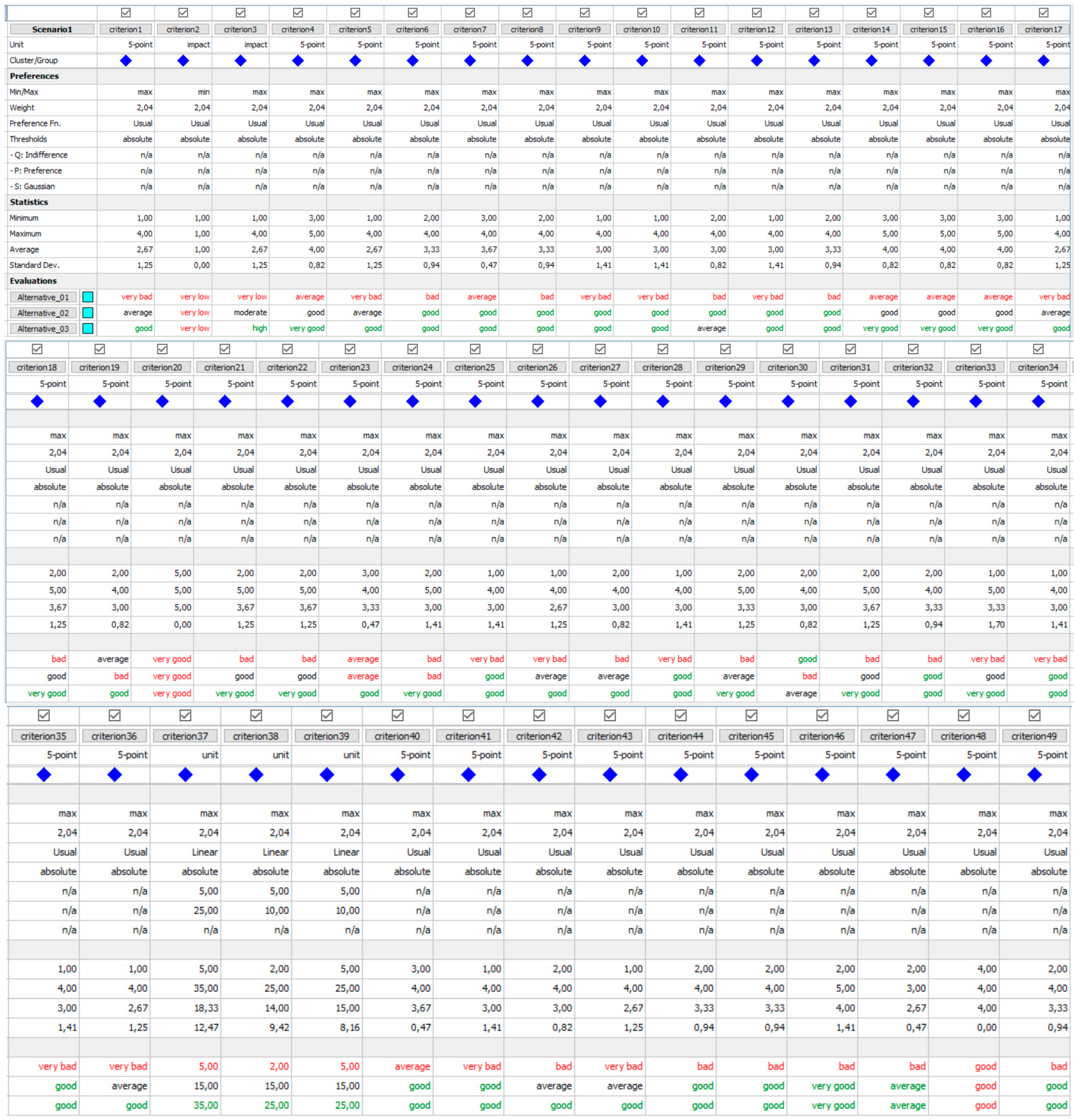
The evaluation step starts with the creation of a decision matrix, shown in Appendix A (Figure A2), where all alternatives have been evaluated by the experts, and the preferences according to each criterion have been precisely stated. Herein lie the major benefits of PROMETHEE methods in relation to other multi-criteria and outranking methods: the possibility to simultaneously compare alternatives according to different types of criteria (qualitative and quantitative) and to compare alternatives according to a large number of criteria.
As defined, the HGS consists of 49 qualitative and quantitative criteria (Table 5) to evaluate the best alternative strategic plan scenario. For qualitative criteria, the Usual preference function is proposed, while for quantitative criteria, the Linear preference function is proposed. These two preference functions are considered to adequately provide decision-makers with a sufficient number of options to accommodate most typical situations in evaluating and prioritizing alternative strategic plan scenarios.
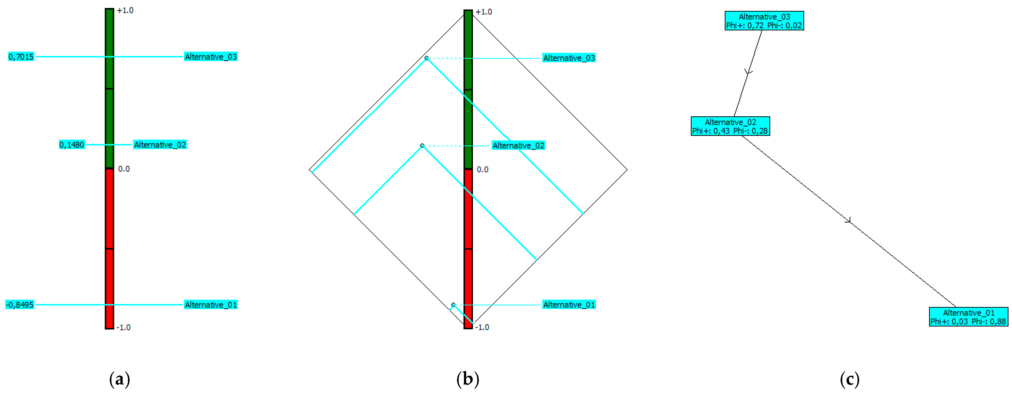
Taking all of these into account, the prioritization step is achieved by performing the PROMETHEE II method, as the results are shown in the complete ranking form (Figure 6). Since the Phi net flow of each compared alternative is clearly visible, the optimal solution is clearly shown regardless of the displayed result option: PROMETHEE II (Figure 6a), PROMETHEE Diamond (Figure 6b), or PROMETHEE Network (Figure 6c). All aforementioned displays show the strengths and weaknesses of each alternative in relation to the defined HGS and all criteria. In PROMETHEE methods, the Phi net flow is defined on a +1 (green) to −1 (red) scale. This means that the alternative closest to +1 is perceived as the best one out of all analyzed alternatives, while the alternative closest to −1 is perceived as the worst one. Knowing such, and by looking into these displays, it is evident that the alternative “Alternative_03” in the Delta area case study is the best one, i.e., optimal for this particular problem.
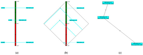
Figure 6.
Results of multicriteria analysis from the SPUR model by means of the VisualPROMETHEE software: (a) PROMETHEE II; (b) PROMETHEE Diamond; (c) PROMETHEE Network.
Knowing the best and worst alternatives is important, as well as knowing the span between them. The large span between the best and worst alternatives (+0.7015 and −0.8495) gives the data analyst insight and confidence that the HGS and criteria, in spite of their large number, are solid and correctly defined. This is a crucial step of the validation process when data is analyzed with outranking methods such as PROMETHEE. If the span between the best and worst alternatives is narrow, additional analysis should be conducted focusing on overlapping goals and criteria.
In addition, the results from Figure 6 indicate that one of the strategic plan solutions is a far better choice than the other to achieve sustainable development. To support such claims, it is important to test and validate complete ranking results not just with the PROMETHEE II method (complete ranking of alternatives) but also how such corresponds with PROMETHEE Diamond (comparability of alternatives) and PROMETHEE Network (proximities between flow values). Such a synergic effect of PROMETHEE displays gives data analyst and decision-maker insight and confidence into obtained results before approaching the final step of the SPUR model, i.e., the decision phase.
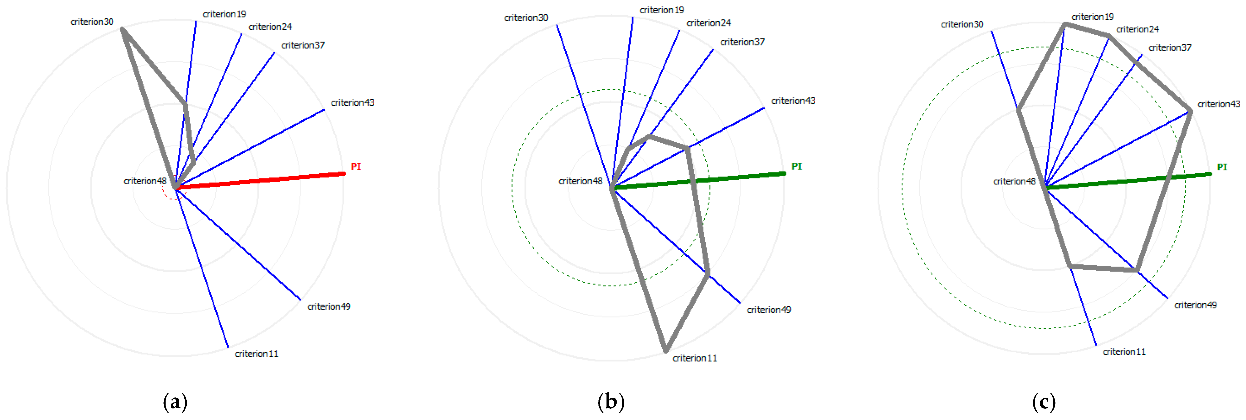
Once the prioritization has been achieved throughout the VisualPROMETHEE, and complete ranking results are validated, the decision-maker can follow the model and make the decision in the decision phase. Also, it is possible to make additional final tunning of the results by changing criteria weights along stability intervals, adding additional heuristics are re-run prioritization, or simply checking unicriterion net flow scores for the selected alternative. This can be done using the GAIA Web based on the GAIA plane, as shown for each alternative in Figure 7. It can be seen that the criteria axes are oriented as in the GAIA plane, while criteria that express similar preferences are located close to each other or overlapped. For each criterion, the radial distance corresponds to the net flow score shown in red as negative Phi (Figure 7a) or green as positive Phi (Figure 7b,c). This can offer additional insight into each alternative concerning unicriterion, at the same time showing the multi-criteria context of complete ranking (dashed circle).
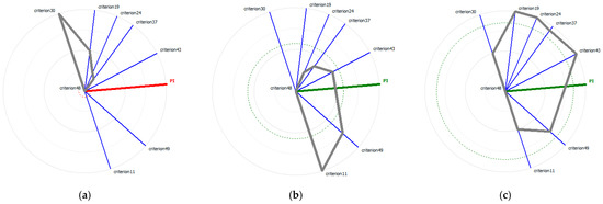
Figure 7.
GAIA web results: (a) Alternative_01; (b) Alternative_02; (c) Alternative_03.
The literature review part Complexity 1 identifies important gaps in the process of decision-making in spatial planning: from goal creation to alternatives creation and evaluation. This is important as the identification of regulatory gaps in environmental policies is one of the important topics of [150], further: EUMLG, as well as the importance of assessment tools. The need for integration of various sectoral analyses, plans, and policies is identified in the review part and is also consistent with [156]. The comparison of topics faced by the SPUR model and [156] is given in Table 6.

Table 6.
Comparison of EUMLG topics with SPUR model principles.
This phase also identifies the problem of power imbalances between the planner and decision-maker (where the planner does not have the decision-making power with which to influence the process). It is also interesting to notice the role of public participation where at times it is expected that planner “helps” the public but also where public can aid the planner with introducing innovative approaches in case the decision-maker is open to accept public opinion, which is not always the case [20]. The analyzed literature shows only recent awareness of the problem of power imbalances between technical and scientific roles and decision-making roles, and even that mostly in South.
The literature review part Complexity 2 indicates the need to use different approaches and tools through the decision-making process in spatial planning and urban management in complex environments, such as HUL. The authors noticed the lack of holistic considerations in the research of SDGs and other topics, which was also noted by other researchers [157]. Therefore, the holistic multi-criteria decision approach could help to deal with the multiplicity of inputs from a very complex human environment, in relation to sustainable urban development goals. For now, the roles of sustainable development goals, resilience and HUL were hindered by the structural obstacles related to processes of spatial planning, urban design and even building design.
The definition of the characteristics of a certain area (urban void) is best done objectively, considering all possible aspects of HUL. In fact, some areas show characteristics of a variety of spatial-functional typologies (ex-industrial site, ex-portual site, etc.). Grasping the complexity helps to determine the stakeholders and orient planning process in more sustainable perspective. In this way, not only, the owner of the site decides based on economic feasibility, but public interest can also be taken into consideration (as uses or resilience strengthening) and a variety of legal and economic tools can be researched to allow for this more complex intervention. Although landscape urbanism has recently been developing into a wide discipline [37], it can be interpreted in many different ways, from landscape architecture to landscape design to more planning and process-oriented practices [38]. The proposed approach is considering the spatial area in the perspective of holistic attitude towards space of European Landscape Convention and HUL. Considering complexity and evolutive nature of spatial processes it is a landscape-based spatial planning approach. Therefore, landscape is considered in strategic (as it orients every other level of planning and design) and holistic perspective of the two international documents. It is proposed as a part of spatial planning procedures as they are regulated as spatial organization tools in most countries. Landscape approach, based on input from ecological and other sciences, and shifting the attention away from priority of aesthetic approaches, reestablishes the importance of scientific approach to spatial planning.
The literature review part Complexity 3 notices that what makes UN SDGs and HUL different than other “new accents” is both their complexity (they ideally contain all other aspects if elaborated as needed) and their official acknowledgment on international and national level that can be a base for their inclusion in public procurements and official spatial planning legislation. UN SDGs are mostly defined in “people-centric” perspective, where ecological, social, and economic goals are oriented to sustainable development and resilience, therefore a model that allows to verify their implementation can be very helpful in decision-making process. The multi-criteria evaluation model can also help with the improvement of alternatives and the choice of optimal alternative. This model has to be created taking into consideration complexities of HUL and UN SDGs. A multi-criteria evaluation software that can evaluate necessary number of criteria and alternatives was used for this purpose. The proposed MCDA software does not have to be used in similar situations but is recommended because of its’ capability to manage the necessary number of criteria and it visualization characteristics. The deflection values of criteria can help to determine weak aspects of the scenarios and their improvements, and holistic guidelines for implementation (Appendix B, Table A1) can help transfer the goals to the next stage of planning.
In the evaluation model, the characteristics of proposed alternative scenarios are evaluated by spatial planning experts, and some characteristics, depending on the context and existence of relevant sources, might require the assessment by experts from other fields. This aspect can be considered a potential limitation of the model. The model is a synthetic representation of complex systems that requires interpretation of spatial characteristics by planning experts, and based on complexity and context might require interpretation of other experts as well, which might be considered as a limit.
Similar to UN SDGs, New Urban Agenda [158] gives 175 commitments and considerations, mostly related to the provision of essential services for all citizens, equal opportunities, termination of discrimination, pollution reduction, resilience strengthening, climate change reduction, humanitarian aspects, innovations, greening, accessibility, and safety. These goals are partially considered to be obtained through urban planning, mainly through public spaces as points and networks. Although the proposed model is created based on UN SDGs, the similarity of the considered topic makes the proposed model adequate for the implementation in the perspective of the New Urban Agenda. The similarity of the topics proposed by EUMLG with UNSDGs also makes the proposed model useful from the perspective of this research. Primarily, it could be used in the territorial assessment, but also the procurements with impact on sustainable goals. The model also addresses some regulatory gaps (complexity 1) for which the EUMLG requires identification. Building-oriented evaluation approaches such as DGNB and BREEAM [159,160] could be combined with the proposed model in the next phases of spatial intervention, especially in building design (giving holistic guidelines and evaluating building designs).
The proposed model helps to maintain the holistic vision throughout all planning and design levels, starting from a strategic level and giving holistic implementation guidelines for urban and building design. The proposed model is open source (in contrast to cited evaluation models) and oriented to spatial planning, particularly in urban areas with holistic guidelines for implementation (lower levels of planning and designs). It is also modular and flexible, allowing for modification of limit values, making the limit values, goals, evaluations, and prioritization transparent for public participation and communication.
Findings reveal the importance of various sub-topics in spatial planning that are not all new but are recently gaining increasing importance (landscape, green services, resilience, etc.). As it is usually done, the spatial planning process does not necessarily consider those topics nor evaluate possible alternatives. Therefore, it is necessary to create a planning and decision aid tool that can help in scenario creation, evaluation, choice of planning alternatives, and urban management decision-making process in general, allowing for control of complex scenarios, all from a sustainable development perspective.
The SPUR model proposes a strategic, holistic view of spatial issues. A sustainable and resilient perspective is introduced with scenarios based on UN SDGs. The model can be used for the spatial intervention decision-making process in every urbanized or semi-urbanized environment or landscape. The model can help guide the spatial interventions decision-making, both at strategic and lower planning levels, to respect the principles of sustainability and resilience. In the contexts where the introduction of those aspects is not expected to be introduced in the planning process, the model, by being a part of public procurement, can help to orient the planning and decision-making process in complex sustainable development and resilience perspective.
Additionally, the model can be used in any urbanized area without prominent HUL characteristics: built areas, semi-built areas, voids, central or peripheral. It can be used for the comparison of areas with similar spatial elements or even different elements but similar spatial logic. Further research might be oriented towards resilience evaluation of different cities or for identifying synergies of networks of public and resilient spaces. With adequate resources, the model could be the base for machine learning based on objective criteria based on sustainable and resilient goals. This would greatly aid the creation of adequate alternative scenarios. The model could also be verified for use in combination with GIS technologies. Also, the model could be further developed for the lower level of spatial planning, in the combination with topo-geographical, morphological, and pattern language principles.
5. Conclusions
It is possible to create a tool that can help such processes and manage different inputs and evaluate alternatives for achieving sustainable urban development, based on the characteristics of complex HUL areas and UN SDGs. For this, the analysis of contemporary spatial planning topics was needed, so to define criteria that could be easily used in other similar situations.
The model can be used to fill a gap in the planning and decision-making process as a support tool in a decision on spatial interventions in complex urban environments from a sustainable and resilience perspective. The model is oriented towards strategic planning, with holistic guidelines for urban planning and design as well as building design in terms of resilience, but does not evaluate single buildings for their best use. However, if needed, it can be used together with a building-oriented model such as [161]. Besides the functionality of a model, the fact that it is based on internationally and nationally adopted documents related to SDGs can add additional weight to its introduction in the decision-making process, for example, through the public procurement requirement [162], as suggested in [92].
The main contribution of the SPUR model is that it connects the characteristics of complex environments such as HULs and UN SDGs and answers the need to analyze, evaluate and give holistic guidelines in multi-scale multi-dimensional [98], and multi-goal perspectives, using as the bases accepted international values and goals (UN SDGs), complex urban environments in a manageable and communicable way without diminishing the complexity of socio-ecological [110] environments. Therefore, the proposed model preserves the spatial area’s complexity and helps define and improve alternative intervention scenarios. Prioritization and decisions can be made using a simple comparison of alternatives or using additional restraints. The model proposes a basic deflection value for every criterion under which the alternative doesn’t satisfy the criteria. This helps to recognize the weak points of the proposals (even a single one, but also of alternative proposals) and can help to improve the proposal(s) before prioritization and decision on the choice of alternative.
Although the model is a strategic planning decision-aid tool, it takes into account the connection between different levels of planning (for example, an area that is defined as residential can be more or less resilient depending on urban design characteristics and even on building design characteristics), and gives holistic guidelines for the lower level of planning to assure that the sustainability and resilience principles are maintained throughout all levels of planning and design. This aspect is important as the quality of spatial interventions, planning, and development program is more important than the quality of single building designs.
As the model is based on the internationally accepted documents, it can be a basis for evaluations of sustainability goals in complex environments that can be a part of public procurements. This is especially important in the EU field where the topics of EUMLG share the same perspective of UN SDGs, including bridging the regulatory gaps.
Author Contributions
Conceptualization, I.M. (Iva Mrak) and I.M. (Ivan Marović); methodology, I.M. (Iva Mrak) and I.M. (Ivan Marović); software, I.M. (Iva Mrak), I.M. (Ivan Marović) and D.A.; validation, I.M. (Iva Mrak), I.M. (Ivan Marović) and D.A.; formal analysis, I.M. (Iva Mrak), I.M. (Ivan Marović) and D.A.; investigation, I.M. (Iva Mrak), I.M. (Ivan Marović) and D.A.; resources, I.M. (Iva Mrak), I.M. (Ivan Marović) and D.A.; data curation, I.M. (Iva Mrak), I.M. (Ivan Marović) and D.A.; writing—original draft preparation, I.M. (Iva Mrak), I.M. (Ivan Marović) and D.A.; writing—review and editing, I.M. (Iva Mrak) and I.M. (Ivan Marović); visualization, I.M. (Iva Mrak), I.M. (Ivan Marović) and D.A.; supervision, I.M. (Iva Mrak) and I.M. (Ivan Marović); project administration, I.M. (Iva Mrak) and I.M. (Ivan Marović); funding acquisition, I.M. (Iva Mrak) and D.A. All authors have read and agreed to the published version of the manuscript.
Funding
This research received no external funding.
Institutional Review Board Statement
Not applicable.
Informed Consent Statement
Not applicable.
Data Availability Statement
Data are available on request due to restrictions, e.g., privacy or ethics. The data presented in this study are available on request from the corresponding author. The data are not publicly available due to further research being published.
Acknowledgments
This research has been fully supported by the University of Rijeka under the project number uniri-pr-tehnic-19-18 (http://dsc4sum.gradri.uniri.hr) (accessed on 8 September 2022).
Conflicts of Interest
The authors declare no conflict of interest.
Appendix A
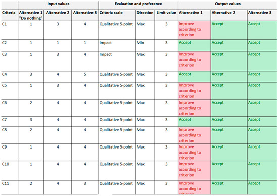
Figure A1.
Table of evaluation of criteria, definition of preference function, and visualization of criteria fulfilment—Extract (green cell—acceptable result, red cell—not acceptable result).
Figure A1.
Table of evaluation of criteria, definition of preference function, and visualization of criteria fulfilment—Extract (green cell—acceptable result, red cell—not acceptable result).
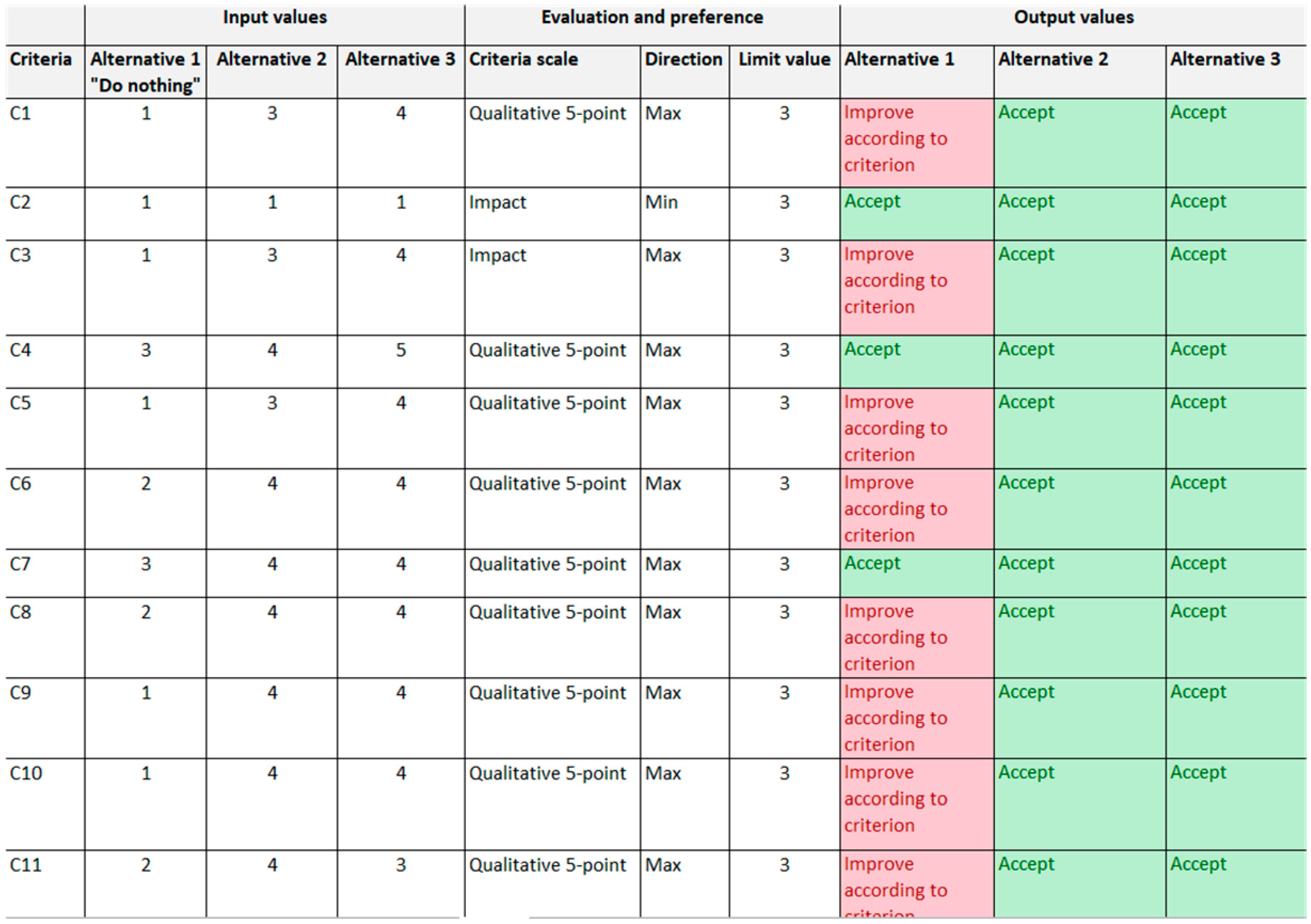
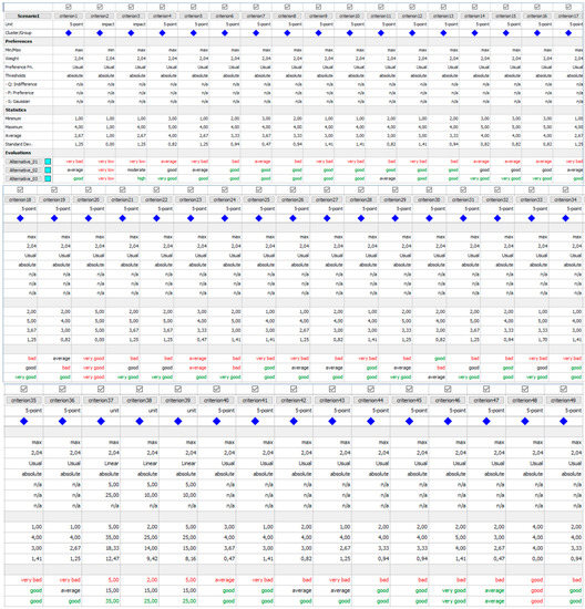
Figure A2.
Decision matrix from VisualPROMETHEE.
Figure A2.
Decision matrix from VisualPROMETHEE.
Appendix B

Table A1.
Holistic Implementation Guidelines for lower levels of spatial planning, urban and building design.
Table A1.
Holistic Implementation Guidelines for lower levels of spatial planning, urban and building design.
| Criteria | Guidelines |
|---|---|
| C1 | Determination of major risks in the area, continuous data gathering and monitoring, information and analysis updating, open access to information, coordination of spatial management activities, empowerment of population Interventions oriented to of risk reduction and prevention, and resilience strengthening Depending on type of risk (in consultation with experts), interventions such as (but not exclusively): Physical interventions oriented to reduction of risk and management of risk: Creation of dykes, ditches, canals, increasing river profile, creation raising the lend level, creation of expansion zones, creating safe communication inside and with outside the area, shelters and community gathering zones Soil reinforcements interventions and anti-desertification infrastructure and measures Building based on earthquake and fire safety codes In-between distance adequate for seismic risk and communication necessities Distances adequate for fire prevention and accesses Healthy buildings and design based on sustainability certificates or evaluations Climate active buildings and urban design (interventions that mitigate UHI and other effects of extreme weather) Ecological network and other green infrastructure (green roofs and facades, ponds…) Conservation of heritage Recycling and production of water and energy, adequate waste management Introduction/renewal of basic services in households Soil strengthening and adequate land-use zoning avoiding the areas that cannot be managed safely Built systems that can function during expected risks Safety equipment located in adequate locations, including mobile infrastructure (ITC, bridges…) Interventions that guarantee access to basic services, in private spaces and especially in public spaces even during risk periods Universal design for all places related to risk management and risk management plans Universal design for all public and workspaces, incentives for private spaces |
| C2 | Interventions that do not impact agricultural areas directly or indirectly |
| C3 | Area(s) oriented to aid small food producers, in particular vulnerable and indigenous groups, and help sustainable small production and resilience of ecosystems and local animal and plant species Interventions that improve ecosystems, and that strengthen resilience to climate change of the area and possible of nearby areas |
| C4 | Interventions that guarantee transport for all potential area users, including vulnerable groups and economic activities. Assure adequate areas and infrastructure for all modes of transport Safety measures as a part of all infrastructure design and management Urban organization based on topo-geographical and morphological analysis and pattern language |
| C5 | Healthy buildings Urban design that reduces and recycle pollutants, and increase air, water, and soil quality |
| C6 | Interventions that create safe environments (without violence and crimes) and safe access to all accessible areas Urban organization based on topo-geographical morphological analysis and pattern language Adequate infrastructure (ICT, co working hubs…) and universal design approach to allow equal opportunities |
| C7 | Urban interventions that collect, recycle, and purify water Building designs that that collect, recycle, and purify water Intervention that reduces water pollution (dumping, chemicals, wastewater…) and help sustainable (including easy and effective) waste management Interventions that implement integrated water resources management (harvesting, desalination, wastewater treatment, recycling and reuse) Interventions that protect and restore water-related ecosystems, both visible and not visible (aquifers) |
| C8 | Introduction and renewal of sanitary service both private (through financial and administrative schemes) and public (such as toilets and showers etc., based on universal design) and oriented to optimize water use and recycling |
| C9 | Installation of drinking water points in public spaces, resistant to risk and emergencies Improvement of private access to drinking water (through financial and administrative schemes) and water purification Interventions that allow sustainable withdrawals and supply of freshwater |
| C10 | Climate active buildings and urban design (interventions that mitigate UHI and other effects of extreme weather) Buildings and urban spaces that produce energy Energetically partially self-sufficient area (specially in case of emergencies) |
| C11 | Monitoring of economic situation and quality of jobs and organizing learning opportunities for reorientation Adequate infrastructure for quality work (such as IT infrastructures, co-working hubs, and universal design approach) Quality urban design and secondary services Policies that promote entrepreneurial culture and aid in formalization of SMEs Policies that promote tourism based on local culture and products and job creation |
| C12 | Interventions that allow for diversification of jobs and sectors with a focus on high value-added and labor-intensive sectors Interventions that create safe working environments |
| C13 | Adequate infrastructure for quality work (such as IT infrastructures, co-working hubs, and universal design approach) Spaces adaptable for new functions Comfort and healthy buildings Urban design offering well-being in open spaces Universal design for all public and workspaces For areas outside residential areas, intervention promotes inclusive and sustainable industrialization, for centralized areas or local centers, the intervention promotes functions and functional mixes adequate to its location and geographic significance Interventions that promote domestic technology development and innovation in developing countries |
| C14 | All mobility needs for the area resolved inside the area |
| C15 | Evaluation and choice of urban and building designs in design phases for the CO2 emission Monitoring |
| C16 | Mix of uses determined based on the role and position of urban area in regional and local context Determining the need of local population and economic sectors Use or reuse in resilience perspective, and verifying for new complex approaches Implementation of procedures for inclusive urban planning Implementation of procedures for sustainable urban planning Interventions oriented to improve safety and accessibility in public transportation system |
| C17 | Intervention of valorization of natural and cultural heritage |
| C18 | Universal and inclusive design for public spaces, including green spaces Urban organization based on topo-geographical analysis, morphological analysis and pattern language Public space as a hub and shelter in case of higher impact emergencies |
| C19 | Universal and inclusive design for public spaces, including green spaces Urban organization based on topo-geographical analysis, morphological analysis and pattern language |
| C20 | Evaluation of interventions during urban design and building design phases |
| C21 | Interventions that reduce vibrations and noise from different activities Universal design of public spaces Public transport and resting places every 300 m Public infrastructure planned and design in safety and resilience perspective |
| C22 | Urban design based on topo-geographical analysis, morphological analysis, pattern language and universal design |
| C23 | Urban design based on topo-geographical analysis, morphological analysis, pattern language, mobility, universal design, and wayfinding |
| C24 | Evaluation and choice of visual impact in urban and building design phases |
| C25 | Activities of urban planning and design of contact areas in occasion of planning bigger urban area, based on the same principles as the main area |
| C26 | Analysis of natural, cultural, and social environment and proposal and evaluation of activities based on existing resources and valorizing existing resources Interventions that define waterfronts |
| C27 | Urban design based on evaluation of proposals during urban and infrastructure/building phase, and based on complex spatial approach and topo-geographical analysis (such as to connectivity, visibility, and axial analysis, as well as walkability indexes), pattern language and universal design |
| C28 | Green infrastructure planned and design in resilience and universal design perspective and evaluated as such |
| C29 | Analysis of natural, cultural, and social environment and proposal and evaluation of recreational activities based on existing resources and valorizing existing resources and allowing all year use and seasonal variation use Interventions that define waterfronts and/or other characteristic spatial elements |
| C30 | Definition of adequate limits of gentrification and evaluation of potential gentrification and choice of alternative Interventions that allow for equal use of space and empower and promote inclusion |
| C31 | All year possible use of public spaces and activities based on universal design Primary all year use and secondary uses depending on seasons for public spaces and activities Reservation of a determined percentage of private activities that guarantee all year use and seasonal variation use Interventions that provide universal and safe access to green and public spaces |
| C32 | Definition of various uses context, with predominantly public use and resilience-oriented infrastructure |
| C33 | Creation of safe spaces that can be used as emergency meeting and waiting places, equipped with necessary aids and resources for primary needs, including water, food, and medicine according to preventive information and evaluation, a with basic emergency specialized equipment, and with particular attention to crime prevention during emergencies and secure alternative access to and from the area and safe places Communications protected from risks (elevated paths, resilient ICT, etc.) Creation of shelters for defined area of interest (it can be bigger than the area in question), equipped according to standard regulation and universal design Interventions to diminish risks of disasters, especially water related, but also other natural disasters such as seismic or fire (as in C1 guidelines) |
| C34 | Urban building design that allows for sustainable waste management (in easy and efficient way, considering also vulnerable population) and defined adequate areas and technologies Evaluation of urban and building designs for the issue of waste management |
| C35 | Urban and building design that reduce noise, vibrations, glow, and light pollution (choice of illumination, walls and window, orientation, green and other screening and absorption elements, etc.) |
| C36 | Evaluation and choice of urban and building design for ecological network efficiency Urban design that aids in air, water, and soil purification |
| C37 | (Percentage of green areas:) Definition of minimum limit, recommended 15% Safe, accessible, and universal |
| C38 | (Percentage of sport and recreation areas:) Definition of minimum limit, recommended 15% Safe, accessible, and universal |
| C39 | (Percentage of other public areas:) Definition of minimum limit, recommended 10% Safe, accessible, and universal |
| C40 | Improvement of natural areas and green infrastructure inside and optionally outside the area Interventions that allow long-term sustainable use of resources, especially energy and materials |
| C41 | Urban design based on long-term circular economy principles Building design improving circularity of construction Public procurement that promotes sustainable development Urban design and spatial management that helps with information on sustainable lifestyles |
| C42 | Analysis of natural, cultural, and social environment and proposal and evaluation of touristic activities based on existing resources and valorizing existing resources, respecting and complementing local population demand and offer Evaluation and choice of touristic activities that complement and enhance local offer |
| C43 | Interventions that strengthen resilience and mitigate climate change effects, including temperature, wind, overexposure to sun, humidity, sea level rising, river drying, extreme rain and weather in general, and desertification Combination of low and high technologies for the resilience Interventions in C1 and others based on expected risks |
| C44 | Interventions that reduce marine and coast pollution Requalification of marine and coastal ecosystems with hard and soft interventions to achieve their maximum resilience Depending on location, intervention of conservation of coastal and marine areas |
| C45 | Infrastructure for equality access to marine resources Accessible markets—physically, economically, and administratively |
| C46 | Definition of local needs and designation of adequate area at seaside and sea for local community and their activities |
| C47 | Planning, evaluation and choice of planning and management options that best preserve and restore terrestrial ecosystems and habitats and connect them in the ecological network, and the optimal organization of ecological network in defined area Punctual interventions of preservation and restoring of ecosystems and habitats Management plan of sustainable use of terrestrial resources in the area Intervention of soil restoration and anti-desertification |
| C48 | Urban and building design based of safety principles including urban design organization based on topo-geographical analysis, morphological analysis and pattern language Transparent public procurement methods in all phases—in planning, design, construction, and utilization phases Opportunity for public participation in planning and design |
| C49 | Analysis and evaluation of different/multiple financial sources potential Process with multi-stakeholders organization with knowledge and skills exchange Cost-benefit analysis of urban and building design base on multicriteria evaluations for sustainability goals (for socio-cultural, ecological, and economic sphere) Analysis of different partnership opportunities and portfolio building |
References
- United Nations. Transforming Our World: The 2030 Agenda for Sustainable Development (A/RES/70/1, 25 September 2015); United Nations: New York, NY, USA, 2015; Available online: https://www.un.org/ga/search/view_doc.asp?sym-bol=A/RES/70/1&Lang=E (accessed on 25 July 2022).
- Avrami, E.; Mason, R.; De la Torre, M. editors. Values and Heritage Conservation: Research Report; Getty Conservation Institute: Los Angeles, CA, USA, 2000; Available online: http://hdl.handle.net/10020/gci_pubs/values_heritage_research_report (accessed on 27 August 2022).
- UN/MAP. Mediterranean Quality Status Report. Mediterranean Action Plan Barcelona Conv. 2017, p. 539. Available online: https://www.medqsr.org/sites/default/files/inline-files/2017MedQSR_Online_0.pdf (accessed on 27 August 2022).
- Parliamentary Assembly of the Mediterranean. Carta del Mediterraneo; Parliamentary Assembly of the Mediterranean: Principato di Monaco. 2008; pp. 1–15. Available online: https://www.isnitti.edu.it/stdoc/pam_carta.pdf (accessed on 25 July 2022).
- Viganò, P. Extreme cities and bad places. Int. J. Disaster Risk Sci. 2012, 3, 3–10. [Google Scholar] [CrossRef]
- UNESCO. Recommendation on the Historic Urban Landscape; UNESCO: Paris, France, 2011; pp. 1–64. [Google Scholar]
- Pickard, R.; De Thyse, M. The Management of Historic Centres: Towards a Common Goal. In Management of Historic Centres; Pickard, R., Ed.; Spoon Press: London, UK, 2001. [Google Scholar]
- Throsby, D. Economics and Culture; Cambridge University Press: Cambridge, UK, 2001. [Google Scholar]
- Mason, R. (Ed.) Economics and Heritage Conservation: Concepts, Values and Agendas for Research, in Economics and Heritage Conservation, a Meeting Organized by the Getty Conservation Institute; Getty Conservation Institute: Los Angeles, CA, USA, 1998. [Google Scholar]
- UNESCO, Centre UWH. The UNESCO Recommendation on the Historic Urban Landscape, Report of the Second Consultation on Its Implementation by Member States; UNESCO Centre UWH: Paris, France, 2019. [Google Scholar]
- Lagopoulos, A. Land-Use Planning Methodology and Middle-Ground Planning Theories. Urban Sci. 2018, 2, 93. [Google Scholar] [CrossRef]
- Lagopoulos, A. Clarifying Theoretical and Applied Land-Use Planning Concepts. Urban Sci. 2018, 2, 17. [Google Scholar] [CrossRef]
- Mrak, I. Locally based development-tools for identifying opportunities and evaluating port area strategies of Rijeka. Sustainability 2013, 5, 4024–4056. [Google Scholar] [CrossRef]
- Berger, P.L.; Luckmann, T. The Social Construction of Reality; Doubleday and Co.: Garden City, NY, USA, 1966. [Google Scholar]
- Đorđević, D.; Dabović, T. Seven models of planning. Glas. Srp. Geogr. Drus. 2009, 89, 3–22. [Google Scholar] [CrossRef]
- Watson, V. “The planned city sweeps the poor away...”: Urban planning and 21st century urbanisation. Prog Plann. 2009, 72, 151–193. [Google Scholar] [CrossRef]
- Watson, V. Down to earth: Linking planning theory and practice in the “metropole” and beyond. Int. Plan Stud. 2008, 13, 223–237. [Google Scholar] [CrossRef]
- Mrak, I. Evaluation methods in the protection of built heritage. Gradjevinar 2014, 66, 127–138. [Google Scholar]
- Elster, J. The Market and the Forum: Three Varieties of Political Theory. In Deliberative Democracy. Essays on Reason and Politics; Bohman, J., Rehg, W., Eds.; The MIT Press: Cambridge, MA, USA, 1997; pp. 14–15. [Google Scholar]
- Mrak, I.; Matan, C. Can You Access Culture? an Evaluation Model for the Accessibility of Cultural Locations. Electron. J. Fac. Civ. Eng. 2022, 13, 32–46. [Google Scholar] [CrossRef]
- Watson, V. Planning and Development. Int. Encycl. Soc. Behav. Sci. Second Ed. 2015, 25, 180–186. [Google Scholar]
- Stagl, S. The role of the participative multicriteria evaluation in energy planning (In Italian: Il Ruolo Della Valutazione Multicriteria Partecipata Nella Pianificazione Energetica). In Energy, Beauty, Participation: Sustainability Challenge. Evaluations Integrative between Conservation and Development (In Italian: Energia, Bellezza, Partecipazione: La Sfida Della Sostenibilità. Valutazioni Integrate Tra Conservazione e Sviluppo; Fusco Girard, L., Nijkamp, P., Eds.; FrancoAngeli: Milano, Italy, 2004. [Google Scholar]
- Bohman, J.; Rehg, W. Deliberative Democracy. Essays on Reason and Politics; The MIT Press: Cambridge, MA, USA, 1997; p. 23. [Google Scholar]
- Rafieian, M.; Ghazaie, M. Examining the Causes of Crisis in Urban Planning, with an Emphasis on Radical Planning Theory. Int. J. Arch. Eng. Urban Plan 2020, 30, 212–221. Available online: https://www.researchgate.net/publication/344582849 (accessed on 20 August 2022).
- Salingaros, N.A. Unified Architectural Theory: Form, Language, Complexity, 2nd ed.; Vajra Booksz: Kathmandu, Nepal, 2013. [Google Scholar]
- Harrison, H.; Birks, M.; Franklin, R.; Mills, J. Case study research: Foundations and methodological orientations. In Forum Qualitative Sozialforschung/Forum: Qualitative Social Research; Freie University: Berlin, Germany, 2017; p. 18. [Google Scholar]
- Dabović, T.; Đorđević, D. Towards the reconstruction of planning theory/Ka rekonstrukciji teorije planiranja. Glas. Srp. Geogr. Drus. 2008, 88, 37–50. [Google Scholar] [CrossRef]
- Maricchiolo, L. The modern appropriation of urban space through Mediterranean medinas. In Proceedings of the Regionalism, Nationalism & Modern Architecture Conference Proceedings, Porto, Portugal, 25–27 October 2018; Pimentel, J.C., Trevisan, A., Cardoso, A., Eds.; CEAA: Porto, Portugal, 2018; pp. 221–236. [Google Scholar]
- Capasso, M. Hypothesis of livability and development in a Mediterranean Medina with antique center (In Italian: Ipotesi di vivibilità e sviluppo di una Medina mediterranea dal cuore antico). In Charm of the Old Center (In Italian: Il Fascino del Centro Antico); Arcidiacono, C., Ed.; Magma Edizioni: Nalpes, Italy, 2004; pp. 125–137. [Google Scholar]
- Salvati, L. Identity, Change and Sustainability: Towards Post-Mediterranean Cities? Int. J. Hum. Soc. Sci. 2014, 4, 34–41. [Google Scholar]
- Đorđević, D.; Dabović, T. The crisis of European spatial development policy/Krize evropske politike prostornog razvoja. Glasnik Srpskog Geogr. Drus. 2005, 85, 111–118. [Google Scholar] [CrossRef]
- Katurić, I.; Šmit, K.; Hajdinjak, I.; Kranjec, K. Development Strategiesas Key Factors for Sustainable Urban Development. Comparative Analysis of Antwerpen, Bratislava, Krakow and Zagreb. (In Croatian: Razvojne strategije kao čimbenik održivog razvoja gradova, komparativna analiza Antwerpena, Bratislave, Krakowa i Zagreba). Prost. Znan. Časopis Za Arhit. I Urban. 2019, 27, 79–87. [Google Scholar]
- Šećerov, V. Strategic Planning of the City (2012) (In Serbian: Strateško Planiranje Grada (2012)); University of Belgrade—Faculty of Geography, Serbian Spatial Planning Association: Beograd, Republic of Serbia, 2012; pp. 222–227. [Google Scholar]
- Muminović, E.; Radosavljević, U.; Beganović, D. Strategic planning and management model for the regeneration of historic urban landscapes: The case of historic center of Novi Pazar in Serbia. Sustainability 2020, 12, 1323. [Google Scholar] [CrossRef]
- Olesen, K. Transforming the Geography of the Welfare State through Neoliberal Spatial Strategies: The Case of Denmark. In Handbook on the Changing Geographies of the State; Mosio, S., Koch, N., Jonas, A.E.G., Lizotte, C., Luukkonen, J., Eds.; Edward Elgar Publishing: Cheltenham, UK, 2020. [Google Scholar]
- Krasilnikova, E.; Klimov, D. Design principles of hybrid spaces in terms of urban planning regeneration. Wit Trans Built Environ. 2020, 193, 89–100. [Google Scholar]
- Vicenzotti, V. The landscape of landscape urbanism. Landsc. J. 2017, 36, 75–86. [Google Scholar] [CrossRef]
- Rahul, P. Landscape urbanism. Landscape 2011, 31, 27–31. [Google Scholar]
- Cermasi, O. Contemporary landscape urbanism principles as innovative methodologies: The design of an armature of public spaces for the revitalisation of a shrinking city. J. Public Sp. 2017, 2, 111. [Google Scholar] [CrossRef]
- North, A.; Waldheim, C. Landscape Urbanism: A North American Perspective. In Resilience in Ecology and Urban Design. Linking Theory and Practice for Sustainable Cities; Pickett, S.T.A., Cadenasso, M.L., McGarth, B., Eds.; Springer: Berlin, Germany, 2013; pp. 391–406. [Google Scholar]
- Zeleny, M. Multiple Criteria Decision Making; McGraw-Hill Book Company: New York, NY, USA, 1982. [Google Scholar]
- Nocca, F. The role of cultural heritage in sustainable development: Multidimensional indicators as decision-making tool. Sustainability 2017, 9, 1882. [Google Scholar] [CrossRef]
- Gómez-Villarino, M.T.; Gómez Villarino, M.; Ruiz-Garcia, L. Implementation of urban green infrastructures in peri-urban areas: A case study of climate change mitigation in madrid. Agronomy 2021, 11, 31. [Google Scholar] [CrossRef]
- Coaffee, J.; Bosher, L. Integrating counter-terrorist resilience into sustainability. Proc Inst. Civ. Eng.—Urban Des. Plan. 2008, 161, 75–83. [Google Scholar] [CrossRef]
- Ran, J.; Nedovic-Budic, Z. Integrating spatial planning and flood risk management: A new conceptual framework for the spatially integrated policy infrastructure. Comput. Environ. Urban Syst. [Internet] 2016, 57, 68–79. [Google Scholar] [CrossRef]
- Hemmati, M.; Mahmoud, H.N.; Ellingwood, B.R.; Crooks, A.T. Shaping urbanization to achieve communities resilient to floods. Environ. Res. Lett. 2021, 16, 094033. [Google Scholar] [CrossRef]
- Yiannakou, A.; Salata, K.-D. Adaptation to Climate Change through Spatial Planning in Compact Urban Areas: A Case Study in the City of Thessaloniki. Sustainability 2017, 9, 271. [Google Scholar] [CrossRef]
- Lukić, B.; Šećerov, V. Planning at the Local Level—Organization, Management, Development (2017) (In Serbian: Planiranje na Lokalnom nivou—Organizacija, Upravljanje, Razvoj (2017)); University of Belgrade—Faculty of Geography: Beograd, Republic of Serbia, 2017; pp. 18–128. [Google Scholar]
- Ambruš, D. The Mechanical City (2020) (In Croatian: Mehanički Grad (2020)); Sustainable Urban Society Association—STRAND: Beograd, Republic of Serbia, 2020; pp. 122–137. [Google Scholar]
- Friel, S.; Akerman, M.; Hancock, T.; Kumaresan, J.; Marmot, M.; Melin, T.; Vlahov, D. Addressing the social and environmental determinants of urban health equity: Evidence for action and a research agenda. J. Urban Health 2011, 88, 860–874. [Google Scholar] [CrossRef]
- Mrak, I. A Methodological Framework Based on the Dynamic-Evolutionary View of Heritage. Sustainability 2013, 5, 3992–4023. [Google Scholar] [CrossRef]
- Carta, M. The Cultural Armour of the Territory. Cultural Heritage as an Identity Matrix and Development Tool (In Italian: L’armatura Culturale del Territorio. Il Patrimonio Culturale Come Matrice di Identità e Strumento di Sviluppo); FrancoAngeli: Milano, Italy, 2002. [Google Scholar]
- Campeol, G.; Pizzinato, C. Methodology for evaluating archaeological impact (In Italian: Metodologia per la valutazione dell’impatto archeologico). Archeol. E Calc. 2007, 18, 273–292. [Google Scholar]
- Fusco, G.L.; Nijkamp, P. The evaluation in the tactical and implementation/management level of sustainable development (In Italian: La valutazione nel livello tattico edattuativo/gestionale dello sviluppo sostenibile). In Assessments for the Sustainable Development of the City and the Territory (In Italian: Le Valutazioni per lo Sviluppo Sostenibile Della Città e del Territorio); Fusco Girard, L., Nijkamp, P., Eds.; FrancoAngeli: Milano, Italy, 1997; pp. 98–122. [Google Scholar]
- Polèse, M.; Stren, R. (Eds.) The Social Sustainability of Cities: Diversity and the Management of Change; University of Toronto Press Incorporated: Toronto, ON, Canada; Buffalo, NY, USA; London, UK, 2000. [Google Scholar]
- Mela, A.; Belloni, M.C.; Davico, L. Sociology and Territorial Planning (In Italian: Sociologia e Progettazione del Territorio); Carocci: Rome, Italy, 2000. [Google Scholar]
- Greffe, X. Culture and Local Development (In Italian: Cultura e Sviluppo Locale); OECD, Provincia Autonoma di Trento: Nicolodi, Trento, 2005. [Google Scholar]
- Greffe, X. Management of Cultural Heritage (In Italian: La Gestione del Patrimonio Culturale); Franco Angeli: Milano, Italy, 2003. [Google Scholar]
- Giucastro, F.G.S.; Giordano, D. Et(h)nic Architecture in Mediterranean Area. Energy Procedia 2016, 96, 868–880. [Google Scholar] [CrossRef][Green Version]
- Fusco Girard, L.; Gravagnuolo, A.; Nocca, F.; Angrisano, M.; Bosone, M. Towards An Economic Impact Assessment. BDC. Boll. Cent. Calza Bini 2015, 2, 265–293. Available online: http://www.serena.unina.it/index.php/bdc/article/view/4061 (accessed on 1 September 2022).
- European Landscape Convention and Explanatory Report Document by the Secretary General Established by the General Directorate of Education. In Culture, Sport and Youth, and Environment; Council of the European Union: Brussels, Belgium, 2000.
- The Australia ICOMOS. Burra Charter: The Australia ICOMOS Charter for Places of Cultural Significance; The Australia ICOMOS: Burwood, Austrailia, 2013. [Google Scholar]
- Harvey, D.C. Heritage pasts and heritage presents: Temporality, meaning and scope of heritage studies. Int. J. Herit. Stud. 2001, 7, 319–338. [Google Scholar] [CrossRef]
- Lichfield, N. Economics in Urban Conservation; Cambridge University Press: Cambridge, UK, 1988. [Google Scholar]
- Venanzoni, G.; Carlucci, M.; Salvati, L. Latent sprawl patterns and the spatial distribution of businesses in a southern European city. Cities 2017, 62, 50–61. [Google Scholar] [CrossRef]
- Zitti, M.; Ferrara, C.; Perini, L.; Carlucci, M.; Salvati, L. Long-Term Urban Growth and Land Use Efficiency in Southern Europe: Implications for Sustainable Land Management. Sustainability 2015, 7, 3359–3385. [Google Scholar] [CrossRef]
- Martino, R.; Foglia, L. The city borders: New opportunities for the Mediterranean city. In Less More Architecture Design Landscape. Le vie dei Mercanti X Forum Internazionale di Studi Gambardella; Gambardella, C., Ed.; La Scuola di Pitagora: Naples, Italy, 2012; pp. 1–8. [Google Scholar]
- De Rosa, F.; Di Palma, M. Historic Urban Landscape Approach and Port Cities Regeneration: Naples between Identity and Outlook. Sustainability 2013, 5, 4268–4287. [Google Scholar] [CrossRef]
- Fiorini, L.; Zullo, F.; Marucci, A.; Di Dato, C.; Romano, B. Planning Tool Mosaic (PTM): A Platform for Italy, a Country Without a Strategic Framework. Land 2021, 10, 279. [Google Scholar] [CrossRef]
- Rahmann, H.; Jonas, M.; Rahman Jonas, M. Urban Voids: The Hidden Dimension of Temporary Vacant Spaces in Rapidly Growing Cities 2011. 2011, pp. 1–11. Available online: https://www.researchgate.net/publication/260094708_Urban_Voids_The_hidden_dimension_of_temporary_vacant_spaces_in_rapidly_growing_cities (accessed on 25 August 2022).
- Hashem, O.M.; Wahba, S.M.E.; Nasr-Eldin, T.I. Urban voids: Identifying and optimizing urban voids potential as a revitalization source in enhancing developing countries’ city income. J. Eng. Appl. Sci. 2022, 69, 1–30. [Google Scholar] [CrossRef]
- Sbacchi, M. Landscape Urbanism and Architecture of the Voids. Procedia Environ. Sci. 2017, 37, 667–675. [Google Scholar] [CrossRef]
- Uzelac, M. Urban Spaces, Non-Places and Bad Places: Intersections Between Theory and Fiction in the Writings of Aldous Huxley and Michel Houellebecq. Metacritic J. Comp. Stud. Theory 2020, 6, 1. [Google Scholar] [CrossRef]
- Feleki, E.; Achillas, C.; Vlachokostas, C.; Michailidou, A.V.; Ortega, L.; Moussiopoulos, N. Preservation of the Mediterranean Identity: An Intra-City Analysis Towards a Macro-Regional Approach for the Characterisation of Urban Sustainability. Sustainability 2018, 10, 3551. [Google Scholar] [CrossRef]
- Mravunac Sužnjević, I.; Šmit, K. Defining the City Skyline; Urban and Architectural Approach Between 1960 and 2020 (2020) (In Croatian: Pojmovno određenje identitetske siluete grada; Urbanističko-arhitektonski pristup od 1960. do 2020. godine. (2020)). Prostor 2020, 28, 390–401. [Google Scholar]
- Ambruš, D. Post-Industrial Cities (2021) (In Croatian: Postindustrijski gradovi (2021)); Sustainable Urban Society Association–STRAND: Beograd, Republic of Serbia, 2021; pp. 56–131. [Google Scholar]
- Hillier, B. Space Is the Machine, 2nd ed.; Space Syntax: London, UK, 2007; pp. 124–137. Available online: https://discovery.ucl.ac.uk/id/eprint/3881/1/SITM.pdf (accessed on 22 August 2022).
- Hakim, B. Mediterranean urban and building codes: Origins, content, impact, and lessons. Urban Des. Int. 2008, 13, 21–40. [Google Scholar] [CrossRef]
- Hakim, B. Generative processes for revitalizing historic towns or heritage districts. Urban Des. Int. 2007, 12, 87–99. [Google Scholar] [CrossRef]
- Alexander, C.; Ishikawa, S.; Silverstein, M.; Jacobson, M.; Fiksdahl-King, I.; Angel, S.A. Pattern Language: Towns, Buildings, Construction; Center for Environmental Structure Series; Oxford University Press: Oxford, UK, 1977. [Google Scholar]
- A New Pattern Language for Growing Regions: Places, Networks, Processes Website. Available online: https://patterns.architexturez.net/doc/az-cf-193137 (accessed on 15 October 2022).
- Ambruš, D.; Dusparić, V. Architectural form as a Construction (2014) (In Croatian: Arhitektonska forma kao struktura (2014.)). In Returning the City (In Croatian: Vraćanje Grada); Sustainable Urban Society Association–STRAND: Beograd, Republic of Serbia, 2019. [Google Scholar]
- Marović, I.; Završki, I.; Jajac, N. Ranking zones model—A multicriterial approach to the spatial management of urban areas. Croat. Oper. Res. Rev. 2015, 29, 91–103. [Google Scholar] [CrossRef]
- Cellamare, C. Cultures and Territorial Design (In Italian: Culture e Progetto del Territorio); Franco Angeli: Milano, Italy, 1997. [Google Scholar]
- Representing Places: Methods and Techniques; Magnaghi, A., Ed.; Alinea: Firenze, Italy, 2001. [Google Scholar]
- Hastaoglou-Martinidis, V. Urban aesthetics and national identity: The refashioning of Eastern Mediterranean cities between 1900 and 1940. Plan. Perspect. 2011, 26, 153–182. [Google Scholar] [CrossRef]
- Dieleman, F.; Kloosterman, R.C. Room to Manoeuvre: Governance, the Post-Industrial Economy, and Housing Provision in Rotterdam. In The Social Sustainability of Cities: Diversity and the Management of Change; Polèse, M., Stren, R., Eds.; University of Toronto Press Incorporated: Toronto, ON, Canada; Buffalo, NY, USA; London, UK, 2000; pp. 175–201. [Google Scholar]
- Hanak, T.; Marović, I.; Aigel, P. Perception of residential environment in cities: A comparative study. Procedia Eng. 2015, 117, 500–506. [Google Scholar] [CrossRef]
- Donella, H.; Meadows, D.H.; Meadows, D.L.; Randers, J.; Behrens, W.W., III. The Limits to Growth of the Club of Rome; Universe Books, United States of America: New York, NY, USA, 1972. [Google Scholar]
- United Nations. Report of the World Commission on Environment and Development: Our Common Future (Brundtland Report); United Nations: Paris, France, 1987. [Google Scholar]
- Munasinghe, M. Environmental Macroeconomics—Basic Principles, Online Ecological Economics Encyclopedia (OEEE), International Society for Ecological Economics (ISEE). 2004. Available online: https://isecoeco.org/pdf/environmental_macroeconomics.pdf (accessed on 25 August 2022).
- Marović, I.; Mrak, I.; Ambruš, D.; Krstičević, J. Building Interventions in Mediterranean Towns—Developing a Framework for Selecting the Optimal Spatial Organization and Construction Technology from a Sustainable Development Perspective. Buildings 2022, 12, 1233. [Google Scholar] [CrossRef]
- UNISDR. Sendai Framework for Disaster Risk Reduction 2017. Available online: http://www.unisdr.org/we/coordinate/sendai-framework (accessed on 22 July 2022).
- Chahardowli, M.; Sajadzadeh, H.; Aram, F.; Mosavi, A. Survey of sustainable regeneration of historic and cultural cores of cities. Energies 2020, 13, 2708. [Google Scholar] [CrossRef]
- Krvavica, N.; Ružić, I. Assessment of sea-level rise impacts on salt-wedge intrusion in idealized and Neretva River Estuary. Estuar. Coast. Shelf Sci. 2020, 234, 106638. [Google Scholar] [CrossRef]
- Ružić, I.; Dugonjić Jovančević, S.; Benac, Č.; Krvavica, N. Assessment of the Coastal Vulnerability Index in an Area of Complex Geological Conditions on the Krk Island, Northeast Adriatic Sea. Geosci. 2019, 5, 219. [Google Scholar] [CrossRef]
- Shaker, R.R.; Rybarczyk, G.; Brown, C.; Papp, V.; Alkins, S. (Re)emphasizing Urban Infrastructure Resilience via Scoping Review and Content Analysis. Urban Sci. 2019, 3, 44. [Google Scholar] [CrossRef]
- Tayebi, S.; Mohammadi, H.; Shamsipoor, A.; Tayebi, S.; Alavi, S.A.; Hoseinioun, S. Analysis of land surface temperature trend and climate resilience challenges in Tehran. Int. J. Environ. Sci. Technol. 2019, 16, 8585–8594. [Google Scholar] [CrossRef]
- Amico, A.D.; Currà, E. The Role of Urban Built Heritage in Qualify and Quantify Resilience. Specific Issues in Mediterranean City. Procedia Econ. Financ. 2014, 18, 181–189. [Google Scholar] [CrossRef]
- Desouza, K.C.; Flanery, T.H. Designing, planning, and managing resilient cities: A conceptual framework. Cities 2013, 35, 89–99. [Google Scholar] [CrossRef]
- Mrak, I.; Campisi, T.; Tesoriere, G.; Canale, A.; Cindrić, M. The role of urban and social factors in the accessibility of urban areas for people with motor and visual disabilities. Aip Conf. Proc. 2019, 2186, 160008. [Google Scholar]
- Centre for Excellence in Universal Design, the 7 Principles. Available online: http://universaldesign.ie/What-is-Universal-Design/The-7-Principles/ (accessed on 17 November 2020).
- Campisi, T.; Basbas, S.; Tesoriere, G.; Trouva, M.; Papas, T.; Mrak, I. How to Create Walking Friendly Cities. A Multi-Criteria Analysis of the Central Open Market Area of Rijeka. Sustainability 2020, 12, 9470. [Google Scholar] [CrossRef]
- Abastante, F.; Lami, I.M.; La Riccia, L.; Gaballo, M. Supporting resilient urban planning through walkability assessment. Sustainability 2020, 12, 8131. [Google Scholar] [CrossRef]
- Lopez, L. The urban reality of a Mediterranean city: Bari (Italy). In New Trends in the Renewal of the City; Piñeira Mantiñán, M.J., Moore, N., Eds.; Instituto Universitario de Estudios e Desenvolvemento de Galicia: Santiago de Compostela, Spain, 2011; pp. 87–103. [Google Scholar]
- Fazio, M.; Giuffrida, N.; Le Pira, M.; Inturri, G.; Ignaccolo, M. Planning Suitable Transport Networks for E-Scooters to Foster Micromobility Spreading. Sustainability 2021, 13, 11422. [Google Scholar] [CrossRef]
- Campisi, T.; Mrak, I.; Errigo, M.F.; Tesoriere, G. Participatory planning for better inclusive urbanism: Some consideration about infrastructural obstacles for people with different motor abilities. Aip Conf. Proc. 2021, 2343, 090006. [Google Scholar]
- Mariano, C.; Marino, M. Public space and climate change. Innovative planning approaches for the urban regeneration of coastal cities. In Proceedings of the International Conference on Changing Cities IV, Spatial, Design, Landscape & Socioeconomics Dimensions; Gospodini, A., Ed.; University of Thessaly, Department of Planning and Regional Development, Laboratory of Urban Morphology & Design: Volos, Greece, 2019; pp. 1772–1783. [Google Scholar]
- Kostrenčić, A.; Jukić, T. Approaches to Urban Design in the Beginning of the 21st Century. Prost. Znan. Časopis Za Arhit. I Urban. 2020, 28, 154–165. [Google Scholar]
- Lu, H.; Campbell, E.; Campbell, D.E.; Wang, C.; Ren, H. Assessment of green infrastructure performance through an urban resilience lens. Atmos Environ. 2017, 23, 248–258. [Google Scholar]
- Larrinaga, F.; Pérez, A.; Aldalur, I.; Hernández, J.L.; Izkara, J.L.; De Viteri, P.S. A holistic and interoperable approach towards the implementation of services for the digital transformation of smart cities: The case of Vitoria-Gasteiz (Spain). Sensors 2021, 21, 8061. [Google Scholar] [CrossRef] [PubMed]
- Deng, D.; Zhao, Y.; Zhou, X. Smart city planning under the climate change condition. IOP Conf. Ser. Earth Environ. Sci. 2017, 81, 012091. [Google Scholar] [CrossRef]
- Ma, Y.; Li, G.; Xie, H.; Zhang, H. City profile: Using smart data to create digital urban spaces. Isprs Ann. Photogramm Remote Sens. Spat. Inf. Sci. 2018, 4, 75–82. [Google Scholar] [CrossRef]
- Prakash, M.; Ramage, S.; Kavvada, A.; Goodman, S. Open Earth Observations for Sustainable Urban Development. Remote Sens. 2020, 12, 1646. [Google Scholar] [CrossRef]
- Li, S.; Juhász-Horváth, L.; Pedde, S.; Pinter, L.; Rounsevell, M.; Harrison, P. Integrated modelling of urban spatial development under uncertain climate futures: A case study in Hungary. Environ Model Softw. 2017, 96, 251–264. [Google Scholar] [CrossRef]
- Iturriza, M.; Hernantes, J.; Abdelgawad, A.A.; Labaka, L. Are Cities Aware Enough? A Framework for Developing City Awareness to Climate Change. Sustainability 2020, 12, 2168. [Google Scholar] [CrossRef]
- Sgobbo, A. Resilience and regeneration: Water sensitive urban planning approach as a sustainable urban strategy (In Italian: Resilienza e rigenerazione: L’approccio water sensitive urban planning come strategia di sostenibilità urbana). BDC Boll. Del Cent. Calza Bini 2018, 18, 105–125. Available online: http://www.serena.unina.it/index.php/bdc/article/view/6061/7239 (accessed on 17 August 2022).
- Bocca, A. Public space and 15-minute city. TeMA—J. Land Use Mobil. Environ. 2021, 14, 395–410. Available online: http://www.serena.unina.it/index.php/tema/article/view/8062 (accessed on 8 September 2022).
- Deluka-Tibljaš, A.; Cuculić, M.; Šurdonja, S.; Babić, S. Analysis of pavement surface heating in urban areas. J. Croat. Assoc. Civ. Eng. 2012, 64, 127–134. [Google Scholar]
- Androjić, I.; Dimter, S.; Marović, I. The contribution to the urban heat islands exploration: Underpasses and their elements. Int. J. Pavement Eng. 2020, 5, 608–619. [Google Scholar] [CrossRef]
- Santamouris, M.; Paolini, R.; Haddad, S.; Synnefa, A.; Garshasbi, S.; Hatvani-Kovacs, G.; Gobakis, K.; Yenneti, K.; Vasilakopoulou, K.; Feng, J.; et al. Heat mitigation technologies can improve sustainability in cities. An holistic experimental and numerical impact assessment of urban overheating and related heat mitigation strategies on energy consumption, indoor comfort, vulnerability and heat-related mortality and morbidity in cities. Energy Build. 2020, 217, 110002. [Google Scholar] [CrossRef]
- Cao, Q.; Huang, Y.; Ran, B.; Zeng, G.; Van Rompaey, A.; Shi, M. Coordination conflicts between urban resilience and urban land evolution in Chinese hilly city of Mianyang. Remote Sens. 2021, 13, 4887. [Google Scholar] [CrossRef]
- Fernandes, J.; Dabaieh, M.; Mateus, R.; Bragança, L. The influence of the Mediterranean climate on vernacular architecture: A comparative analysis between the vernacular responsive architecture of southern Portugal and north of Egypt. In Proceedings of the World Sustainable Buildings 2014 Barcelona Conference, Madrid, Spain, 28–30 October 2014; Green Building Council Espana: Madrid, Spain, 2014; pp. 264–270. [Google Scholar]
- Salvati, A.; Coch, H.; Morganti, M. Effects of urban compactness on the building energy performance in Mediterranean climate. Energy Procedia 2017, 122, 499–504. [Google Scholar] [CrossRef]
- Moretti, A. Destination Management and the Reuse of Cultural Artistic Heritage. In Economia del Patrimonio Monumentale; Mossetto, G., Vecco, M., Eds.; FrancoAngeli: Milano, Italy, 2001; pp. 60–82. [Google Scholar]
- Mossetto, G. The Economy of Art Cities. Comparison of Development Models, Policies and Intervention Tools (In Italian: L’economia delle Città d’arte. Modelli di Sviluppo a Confronto, Politiche e Strumenti di Intervento); EtasLibri: Milano, Italy, 1992. [Google Scholar]
- Šmit, K.; Mravunac, I. Thematic areas of management plans as indicators of contemporary issues in urban planning Mediterranean cities-Dubrovnik, Venice, Corfu/Tematska područja Planova upravljanja kao indikator suvremenih urbanističkih problema. Mediteranski gradovi-Dubrovnik, Venecija, Krf. Prostor 2018, 26, 296–307. [Google Scholar]
- Yiota, T. Cultural heritage as a means for local development in Mediterranean historic cities—The need for an urban policy. Heritage 2020, 3, 152–175. [Google Scholar]
- Costa, C. An emerging tourism planning paradigm? A comparative analysis between town and tourism planning. Int. J. Tour. Res. 2001, 3, 425–441. [Google Scholar] [CrossRef]
- Williams, J. Circular Cities: What Are the Benefits of Circular Development? Sustainability 2021, 13, 5725. [Google Scholar] [CrossRef]
- Carrà, N.; Pultrone, G. Cultural heritage for the construction of social capital in the agenda 2030 territorialization process. ArcHistoR 2019, 12, 330–339. [Google Scholar]
- Van Eck, N.J.; Waltman, L. VOS: A new method for visualizing similarities between objects. In Advances in Data Analysis: Proceedings of the 30th Annual Conference of the German Classification Society; Lenz, H.-J., Decker, R., Eds.; Springer: Heidelberg/Berlin, Germany, 2007; pp. 299–306. [Google Scholar]
- Van Eck, N.J.; Waltman, L. VOSviewer Manual. Manual for VOSviewer Version 1. 6.18 [Internet]; Universiteit Leiden: Leiden, The Netherlands, 2022; Available online: https://www.vosviewer.com/documentation/Manual_VOSviewer_1.6.18.pdf (accessed on 12 July 2022).
- Brans, J.-P.; De Smet, Y. Promethee Methods: Multiple Criteria Decision Analysis; Springer: New York, NY, USA, 2016. [Google Scholar]
- Brans, J.P.; Mareschal, B.; Vincke, P.H. Promethee—A New Family of Outranking Methods in Multicriteria Analysis. Operational Research IFORS 84; Brans, J.P., Ed.; North Holland: Amsterdam, The Netherlands, 1984; pp. 477–490. [Google Scholar]
- Brans, J.P.; Vincke, P.H. A preference ranking organization method, the PROMETHEE method for MCDM. Manag. Sci. 1985, 31, 647–656. [Google Scholar] [CrossRef]
- Behzadian, M.; Kazemzadeh, R.B.; Albadvi, A.; Aghdasi, M. PROMETHEE: A comprehensive literature review on methodologies and applications. Eur. J. Oper. Res. 2010, 200, 198–215. [Google Scholar] [CrossRef]
- VisualPROMETHEE. Available online: http://www.promethee-gaia.net/software.html (accessed on 25 August 2022).
- Marović, I.; Perić, M.; Hanak, T. A multi-criteria decision support concept for selecting optimal contractor. Appl. Sci. 2021, 11, 1660. [Google Scholar] [CrossRef]
- Marović, I.; Car-Pušić, D.; Hrvatin, Z. Establishing a model to evaluate public administration projects. Electron. J. Fac. Civ. Eng. Osijek E Gfos 2014, 5, 56–66. [Google Scholar] [CrossRef]
- Jajac, N.; Bilić, I.; Mladineo, M. Application of multicriteria methods to planning of investment projects in the field of civil engineering. Croat. Oper. Res. Rev. 2012, 3, 113–124. [Google Scholar]
- Jajac, N.; Marović, I.; Baučić, M. Decision support concept for managing the maintenance of city parking facilities. Electron. J. Fac. Civ. Eng. Osijek E Gfos 2014, 9, 60–69. [Google Scholar] [CrossRef]
- Jajac, N.; Marović, I.; Mladineo, M. Planning support concept to implementation of sustainable parking development projects in ancient Mediterranean cities. Croat. Oper. Res. Rev. 2014, 5, 345–359. [Google Scholar] [CrossRef]
- Jajac, N.; Kilić, J.; Rogulj, K. An integral approach to sustainable decision-making within maritime spatial planning—A DSC for the planning of anchorages on the island of Šolta, Croatia. Sustainability 2018, 11, 104. [Google Scholar] [CrossRef]
- Kilić Pamuković, J.; Rogulj, K.; Dumanić, D.; Jajac, N. A sustainable approach for the maintenance of asphalt pavement construction. Sustainability 2021, 13, 109. [Google Scholar] [CrossRef]
- Kilić Pamuković, J.; Rogulj, K.; Jajac, N. Assessing the Bonitet of Cadastral Parcels for Land Reallocation in Urban Consolidation. Land 2021, 10, 31. [Google Scholar] [CrossRef]
- Strategy of City of Rijeka Development for the Period 2014–2020 (In Croatian: Strategija Razvoja Grada Rijeke za Razdoblje 2014–2020. Godine), Rijeka: Grad Rijeka. 2013. Available online: https://www.rijeka.hr/wp-content/uploads/2016/10/strategija-razvoja-2014-2020.pdf (accessed on 10 September 2022).
- Strategy of Urban Agglomeration Rijeka Development, for the Period 2016–2020 (In Croatian: Strategija Razvoja Urbane Aglomeracije Rijeka za Razdoblje 2016–2020. Godine). Rijeka: Grad Rijeka. Available online: https://www.rijeka.hr/wp-content/uploads/2017/03/strategija-urbane-aglomeracije-rijeka.pdf (accessed on 10 September 2022).
- Census ’21. Create Together the Image of Croatia (In Croatian: Popis ’21. Stvorimo Zajedno Sluku Hrvatske) Website. Available online: https://popis2021.hr/ (accessed on 10 September 2022).
- Public, International, Open, in One-Degree, Anonymous, Conceptual Competition for Realization of Conceptual Urbanistic-Architectonic Proposal for the Regulation of Delta Area and Baros Portual Area in Rijeka; Port Authority and City of Rijeka, 2013 (In Croatian: Javni, Međunarodni, Otvoreni, u Jednom Stupnju, Anonimni, Anketni Natječaj za Izradu Idejnog Urbanističkog-Arhitektonskog Rješenja za Uređenja Područja Delte i Luke Baroš u Rijeci; Lučka uprava i Grad Rijeka, 2013). Društvo arhitekata Rijeka Website. Available online: https://d-a-r.hr/preuzimanje-natjecajnih-podloga/ (accessed on 25 August 2022).
- Urlich, A.; Vasiljević, B. General regulation plan of the cities Sušak—Rijeka, 1948 (In Croatian: Direktivna regulaciona osnova gradova Sušak—Rijeka, 1948). Arhitektura 1949, 18–22, 47–51. [Google Scholar]
- Turina, V. Combined swimming pool Rijeka—Sušak (In Croatian: Kombinirano plivalište Rijeka—Sušak). Arhitektura 1950, 7–8, 37–45. [Google Scholar]
- GUP—General Urbanistic Plan of the City of Rijeka (In Croatian: GUP—Generalni Urbanistički Plan Grada Rijeke), City of Rijeka. 2007. Available online: https://www.rijeka.hr/teme-za-gradane/stanovanje-i-gradnja/urbanisticko-planiranje/prostorni-planovi/generalni-urbanisticki-plan-grada-rijeke/ (accessed on 15 July 2022).
- SRP—Spatial Regulatory Plan of City of Rijeka (In Croatian: PPU—Prostorni plan uređenja Grada Rijeke). Official Newspaper SN PGŽ 31/03, 26/05). Available online: https://www.rijeka.hr/teme-za-gradane/stanovanje-i-gradnja/urbanisticko-planiranje/prostorni-planovi/prostorni-plan-uredenja-grada-rijeke/ (accessed on 15 July 2022).
- DPR—Detail Plan of Regulation of Delta Central City Park (In Croatian: DPU—Detaljni PLAN Uređenja Središnjeg Gradskog Parka Delta). 2012. Available online: https://www.rijeka.hr/teme-za-gradane/stanovanje-i-gradnja/urbanisticko-planiranje/prostorni-planovi/detaljni-planovi-uredenja/dpu-sredisnjeg-gradskog-parka-delta/ (accessed on 15 July 2022).
- European Commission, Urban Agenda for the EU. Multi-Level Governance in Action. Brussels, European Commission. 2019. Available online: https://ec.europa.eu/regional_policy/sources/docgener/brochure/urban_agenda_eu_en.pdf (accessed on 10 September 2022).
- Hanna, E.; Comín, F.A. Urban green infrastructure and sustainable development: A review. Sustainability 2021, 13, 11498. [Google Scholar] [CrossRef]
- United Nations, UN-Habitat, The New Urban Agenda. Nairobi, Kenya. 2020. Available online: https://unhabitat.org/sites/default/files/2020/12/nua_handbook_14dec2020_2.pdf (accessed on 10 September 2022).
- German Sustainable Building Council (In German: Deutsche Gesellschaft für Nachhaltiges Bauen) Website. Available online: https://www.dgnb.de/en/ (accessed on 10 September 2022).
- BREEAM Website. Available online: https://bregroup.com/products/breeam/ (accessed on 10 September 2022).
- Claver, J.; García-Domínguez, A.; Sebastián, M.A. Multicriteria decision tool for sustainable reuse of industrial heritage into its urban and social environment. Case studies. Sustainability 2020, 12, 7430. [Google Scholar] [CrossRef]
- European Commission. Innovative and Responsible Public Procurement in Cities. Available online: https://ec.europa.eu/info/eu-regional-and-urban-development/topics/cities-and-urban-development/priority-themes-eu-cities/innovative-and-responsible-public-procurement-cities_en (accessed on 25 July 2022).
Publisher’s Note: MDPI stays neutral with regard to jurisdictional claims in published maps and institutional affiliations. |
© 2022 by the authors. Licensee MDPI, Basel, Switzerland. This article is an open access article distributed under the terms and conditions of the Creative Commons Attribution (CC BY) license (https://creativecommons.org/licenses/by/4.0/).

