1. Introduction
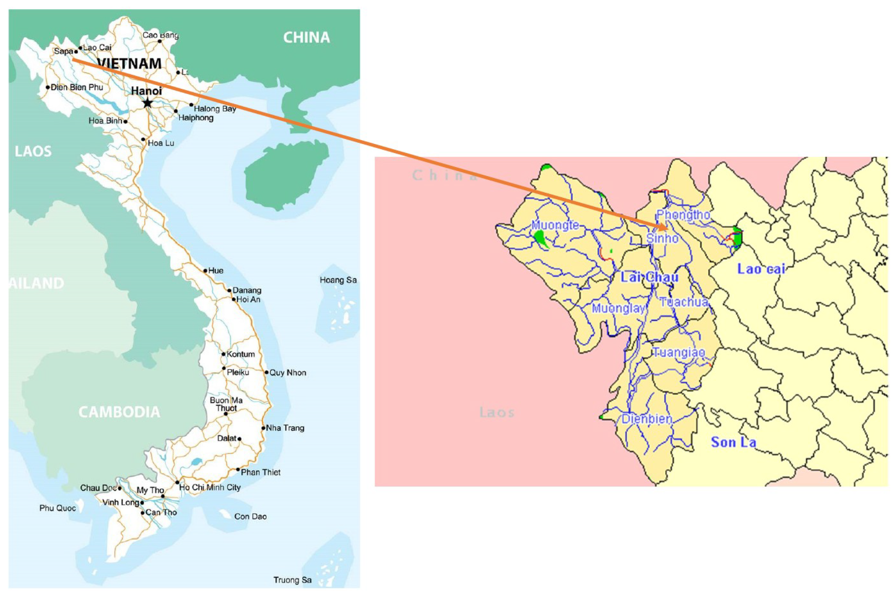
The Namxe rare earth deposit belongs to Namxe commune, Phongtho district, Laichau province, which has a large resource of rare earth metals in Vietnam (
Figure 1). The deposit is divided by the east–west striking Ban Pan-Phong Tho fault into a northern and a southern part, situated on both sides of the Nam Xe river valley. The northern deposit consists of a deeply weathered lateritic ore with thickness up to 40 m on top of a Permian limestone. The southern part, on the other hand, comprises carbonatitic dyke-like structures in a triassic trachyandesitic host rock [
1]. The geological exploration results have shown that the potential resource of Namxe rare earth deposit is about 8 Million Tons of TRE
2O
3 [
2,
3]. Former studies have indicated that the rare earth deposit contents include about 80 different minerals [
4]. Besides rare earth elements, the Namxe deposit even contains some radioactive elements such as uranium and thorium.
The population in the deposit area is mostly the ethnic minorities [
5]. The deposit area has a mountain topographic with steep slopes, which makes it a challenge to collect samples and measure radioactive elements [
6].
The monitoring activities of the natural radioactive environmental investigation at the deposit area included measuring the natural radioactive gases and sampling of soil, water, and flora for further analysis in the labs [
9]. On the basis of the analyzed data and on-site measurements, the map of natural radiation in the local area will be established.
2. Materials and Methods
Radioactive exposure is represented by the equivalent dose H (mSv/year). In order to assess the natural radioactive environment in the mineral deposit, it needs to combine the equivalent dose with other data of airborne radiation, radioactive element concentration, and intensive radiation from radioactive sources, and so on.
2.1. Calculation of Natural Radioactive Environmental Elements in the Mineral Deposit
According to national standards of the geological environmental investigation and National Commission for Sanitary Inspection of Russian Epidemiology [
10,
11], as well as the studies of the Geological Division of Radioactive and Rare Minerals belonging to the General Department of Geology and Minerals of Vietnam [
12,
13,
14], the radioactive environmental impact is determined as follows:
2.1.1. The Equivalent Dose (or Effective Dose)
Equivalent dose
H, is the sum of external dose and internal dose, as in the following expression:
where
Hn is the external dose, which is calculated from measured data of the ambient gamma at the 1 m from ground land, which determinates as:
in which
DN is an equivalent absorbed dose in ambient, (μSv/h);
Ht is the internal dose due to inhalation (
Hp) and ingestion of food and water (
Hd), in mSv per year and is given by:
The inhalation Hp equivalented with an average adult breathing 7280 m3 air per year. Where: HRn = 0.047·CRn (Bq/m3), HTn = 0.007·CTn (Bq/m3); and CRn is 222Rn’s concentration of outdoor air; CTn is Tn’s (220Rn for convenience called Tn—Thoron—hereafter) concentration of outdoor air.
Hd is the effective dose in food crops samples and it is given by:
where K, Ra, Th, U are activities of potassium, radium, thorium, uranium in one liter of water or one kilogram of food (Bq per kg), respectively;
md is the average amount of water or food consumed by a person per year (800 liters of water and 650 kg of food).
2.1.2. Activity Radiation in the Soil Samples
The radiation activity in any soil is determined by:
with
ARa, ATh, AK are activities of Ra, Th, K, respectively.
2.2. Calibration Method
In order to assess the natural radioactive environment, this study used methods of radioactive sampling according to Vietnamese Standards such as TCVN 9414:2012; TCVN 9416: 2012; TCVN 9419:2012 [
15,
16,
17]. Whereby it required to determine the radioactive components in ambient air which include: i) Measurement of gamma dose to determine the external dose of gamma radiation in the studied area; ii) measurement of radioactive gas to determinate the radon concentration in the ambient air, thus calculating the internal dose by inhalation; iii) measurement of gamma spectrum to determinate the concentration of uranium, thorium, and potassium in the soil, rock, and so forth. On the basis of the measured data, the existence and dispersion of radioactive elements in the studied area will be determined.
Error calculating from repetition measurements is determined by the expressions:
and for the relative error
with
.
The indexes Xi and Yi are the measured and repeated measured values at the i, and n is the number of repetition.
2.3. Measuring Methods of Natural Radiation
2.3.1. Measuring the Gamma Dose
The environmental gamma dose was measured in the studied area, directly on the ground and in a vertical distance of 0.1 m above the ground surface with a DKS-96 gamma dosimeter (Doza co.— Moscow, Russia), according to the Vietnamese Standard TCVN 9414:2012 [
15].
2.3.2. Measuring the Radon Concentration
In order to determine the radon concentration in the air, a RAD-7 (Durridge co.— Billerica, USA) was used, and data acquisition was conducted according to the TCVN 9416:2012 [
16]. Radon was measured on the deposit area, in confined rooms and close to the site.
2.3.3. The Measurement of Gamma Spectrum
In order to determine the exiting and dispersion of radioactive elements at the deposit area, the gamma spectrum was measured to determine the concentration of
238U,
232Th, and
40K in the surface soil.
238U was measured using the peak with energy of gamma-quant 1764 keV (
214Bi).
232Th and
40K were measured using the peak with energy of gamma-quant 2614 keV (
208Tl) and 1460 keV, respectively. It was conducted by using a GAD-6 spectrometer (Scintrex Ltd., Concord, ON, Canada), following the procedure described in TCVN 9419:2012 [
17].
2.4. Sampling Method of the Radioactivity in the Soil, Water, and Flora
Soils and waters were sampled according to the national and international standards TCVN 7538-1:2006 (ISO 10381-1:2002), TCVN 7538-1:2006 (ISO 10381-1:2002), and TCVN 6663-1:2011 (ISO 5667-1:2006), respectively [
18,
19,
20], the flora (food crops) samples and analysis according to international standard of International Atomic Energy Agency (IAEA’s standard) [
21].
The position of sampling has been distributed on the deposit area evenly to ensure that the samples cover areas from both the ore deposit area as well as the nearest vicinity.
2.4.1. Water Sampling
The water sampling and analyses were done according to Vietnamese Standard of TCVN 6663-1:2011 (ISO 5667-1:2006), which is described shortly, as followed [
20]:
The water samples were collected at the streams and the points of outfalls following the direction of dispersing radioactive substances in water sources, to evaluate the influence of the radioactive environment on households.
Water samples were taken at depths of 0.2 m and packed in 2 liter plastic canes after they have been rinsed with water at the sampling site. The sampling locations were determined by the GPS positioning method. The water samples were acidified with HNO3 at 0.3% concentration to prevent precipitation.
Analysis of water samples was focused on the determination of total activity α, β and indicators 226Ra, 238U, 232Th, 137Cs, 7Be, and 40K.
2.4.2. Soil Sampling
The soil sampling and analyzing methods were implemented according to Vietnamese Standard TCVN 7538-1:2006 (ISO 10381-1:2002) [
18]. Samples of soils were preferably taken at the sampling sites of plants (food crops). The sampling area was 2.0 × 2.0 m, and the distance of sampling points was 0.5 m. Samples were taken at a depth of 15 cm. Each sample weighed 1 kg. The sampling location was documented by GPS coordinates.
The samples were dried and ground to the grain size of 0.74 mm. Each sample weight was 600 g, which was homogenized and split into 300 g samples for the analysis in a standardized manner.
Analysis of soil samples was focused on 226Ra, 238U, 232Th, 137Cs, 7Be, and 40K.
2.4.3. Flora Sampling
The flora sampling and analyzing methods were implemented according to international standard of IAEA [
21]:
The flora samples were collected from some of the food crops planted, such as rice grains and cassava roots, which are the staple food of the residents in the villages in the vicinity of the ore deposit area. The average weight of each sample was 3.0 kg. The sampling locations were documented by GPS.
The food crops samples were collected and rinsed by the water on site, and then processed by slicing and drying for cassava. The samples were prepared by drying at 105 °C for 48 h, and then they were weighted, and moisture content was determined. The specimens were then heated to temperatures below 450 °C for 48 h to achieve the ash specimens. Weight of ash and ash factor were determined and sent to labs for the analysis. Analysis of food crops samples was undertaken to fully determine the presence of uranium and thorium in plants by analyzing 226Ra, 238U, 232Th, 137Cs, 7Be, and 40K.
3. Results and Discussion
3.1. Determination of Environmental Radioactive Gas Positions
3.1.1. Measurement Localities of the Gamma Radiation
The gamma dose measurement positions were defined by a network measuring along the geological exploration route with a distance of 20 m/point in both the residential and planned future mining area. Outside the mine area, measurement points were set at a distance of 40 m/point, and a total distance measuring line of 200 m was achieved. The total number of completed points was 2165.
3.1.2. Measurement Points for Radon Determination
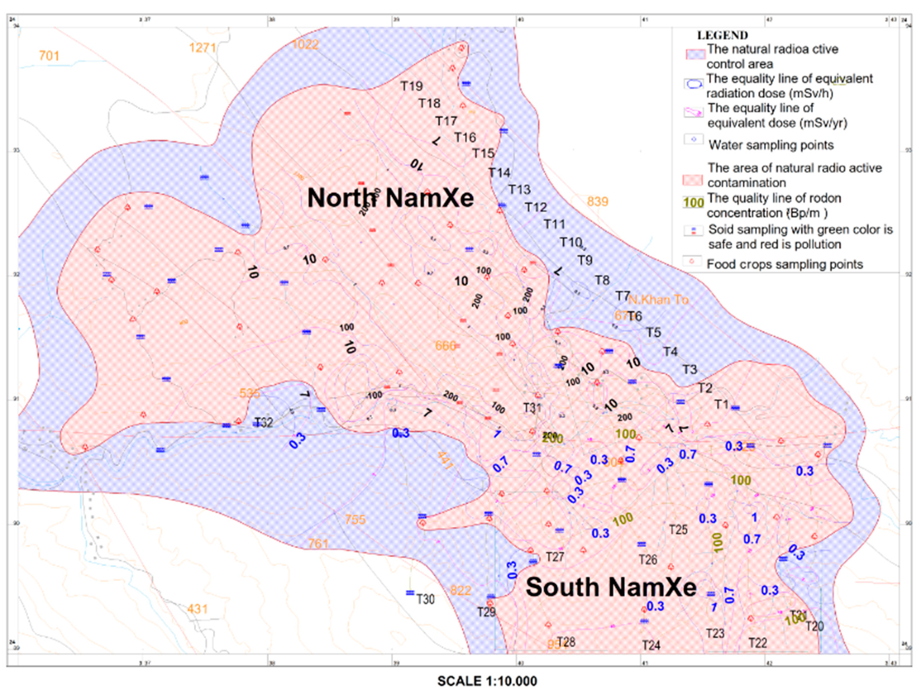
The data point network for radon measurements was set along the geological exploration route, with special focus on radon concentrations in residential areas. Therefore, the investigation on the North Namxe deposit followed data acquisition positions from geological exploration routes of T1 to T11 with the measurement interval of 120 m and 240 m for T12 to T19, respectively (see
Figure 2). The data point distance for the South Namxe deposit was determined to be 120 m within populated and exploration area, and 240 m in the other areas. The total of measured points was 309.
3.1.3. Measurement Points of Environmental Gamma Spectrum
Measurements were carried out along the geological exploration route. The data points were distributed denser in the residential and future mining areas. Specifically, in the North Namxe district, the data points followed the T1 to T11 exploration route with a point interval of 120 m and route T12 to T19 of 240 m, respectively (see
Figure 2). For the South Namxe deposit, again in populated and exploration area, the distance between the data points was 120 m, and in the remaining areas 240 m, respectively. The total number of measured points was 306.
3.2. The Natural Radioactive Environmental Components
After measuring and analyzing data treatment, the results of error assessment are summarized in the
Table 1.
The data assessment of the measured and analyzed data has revealed that they meet current standard criteria. Therefore, the collection data meet the required reliability.
3.2.1. Characterization of Gamma Dose
The gamma dose data have been collected by the net measuring from the whole Namxe rare earth deposit exploration area. Summarized results have shown that the gamma dose at the 0 m position varied from 0.11 to 3.28 µSv per hour, with an average value of 0.69 µSv per hour, and at the 1 m position, varied from 0.10 to 2.46 µSv per hour, with an average value of 0.63 µSv per hour (
Table 2).
The gamma dose level smaller than 0.3 µSv per hour was found in only smaller areas which were close to the border of the area of investigation.
The gamma dose level from 0.3 to 0.6 µSv was found in the transition area between the ore body and the non-ore area, revealing elevated gamma dose rates due to the close distance to the ore body. Respectively, the highest values, ranging from 0.6 to >1.0 µSv per hour were found in the close vicinity of the ore bodies. According to the standard of NRB-96 and NRB-99 [
10,
11], this distribution area is exceeding the secondary class safety standard of gamma dose [
22].
3.2.2. Characterization of Radioactive Gas Concentration
The measured radon gas contribution varied from 6.7 to 465 Bq per air cubic meter, and the mean value was 76.29 Bq per air cubic meter (
Table 3). The positions of high radon concentration were not only depending on the distribution area of ore bodies, but also the areas of limited natural ventilation. In the investigated places of high population density, such as the villages of Mau, Man, Mo, and Namxe, the radon concentration was considerably higher.
According to the standard of TCVN 7889: 2008 [
19], it is not recommended to construct new houses in areas where the Rn’s concentration exceeds 100 Bq per cubic meter, which is, unfortunately, the case in the region.
3.2.3. Characterization of Gamma Spectra in the Soil of the Deposit Area
The results of the gamma spectra measurements in the soils of the deposit area revealed details of the radioactive substances’ concentrations.
Table 4 summarizes the measured data with the respective highest and lowest measured values and averages.
These results have shown that the concentration of thorium and uranium is high, with Th exceeding the U contents.
3.2.4. Alpha and Beta Activity in the Water
The analysis results of alpha and beta activity in the water have shown that the alpha activity value ranged from 0.021 to 0.090 Bq per liter water, with the average value of 0.04 Bq/L, and beta activity ranged from 0.210 to 0.819 Bq/L, with the average value of 0.486 Bq/L. Comparing with the Vietnamese standard of QCVN 08-MT:2015/BTNMT [
23], the threshold limit value of the alpha activity was 0.1 Bq/L and for beta 1.0 Bq/L, respectively. Alpha and beta activity levels in the study are therefore not exceeding the national threshold limit values (
Table 5).
Thus, the radioactivity in the local water environment is generally considered normal (i.e., within the national restrictions). The analysis results of total alpha and beta activity in water in the streams as well as in some nearby localities have shown that there were not any samples exceeding the threshold limit values. Therefore, the water use in the study area is still safe.
3.2.5. Activity of Radioactive Elements in Food Crops
The statistic results of radioactive elements in samples of food crops have shown that the radionuclides of
226Ra,
238U,
232Th,
137Cs,
7Be, and
40K were present in most of the plant samples from Namxe area (
Table 6).
Compared with the standard of NRB-96 [
10], the radioactivity in plant samples exceeded the permitted limitation (
Hd ≤ 0.2 mSv per year), which means that the staple food in the Namxe rare earth deposit has incorporated radioactive ingredients in high doses. The samples had higher
Hd concentrated in the North Namxe, the village of Mau and the regions around the rare earth ore bodies.
3.2.6. The Activity of Radioactive Elements in the Soil
Statistical analysis of the activity of radioactive elements in soils has shown that radioactive isotopes such as
226Ra,
238U,
232Th,
137Cs,
7Be, and
40K were present in most of the soil samples at the Namxe rare earth deposit area (
Table 7).
Analyzes of the soil samples have shown that some soil samples exceeded the 1.000 Bq per kg limit (cf. NRB-96). Those soil samples were taken out from the North Namxe area, which has the use of land to plant the food crop.
Figure 2 shows the distribution of areas with soil samples of high radioactivity (red color)—mainly located in North Namxe. It can be summarized therefore that most of the soil on the surface land of North Namxe is contaminated with radioactive material. According to the threshold limit values of radioactive substances in construction materials, the soil and rock in the North Namxe deposit are not granted to make permanent settlements, or use for landfill, construction of civil works, and so forth.
3.3. Radiation Pollution Partition for the Namxe Rare Earth Deposit
3.3.1. Basic of Radiation Pollution Definition
On the basis of Vietnamese regulations and standards for the environmental protection, the radiation pollution areas in Namxe rare earth deposit were determined. However, some radionuclides have not been regulated in the Vietnamese standards, so they have been applied by the references of the international standards (e.g. IAEA [
21], ICRP, [
24,
25]).
Main standard applied
The recommendations of ICRP have been used for the health safety and environmental protection of the natural radiation.
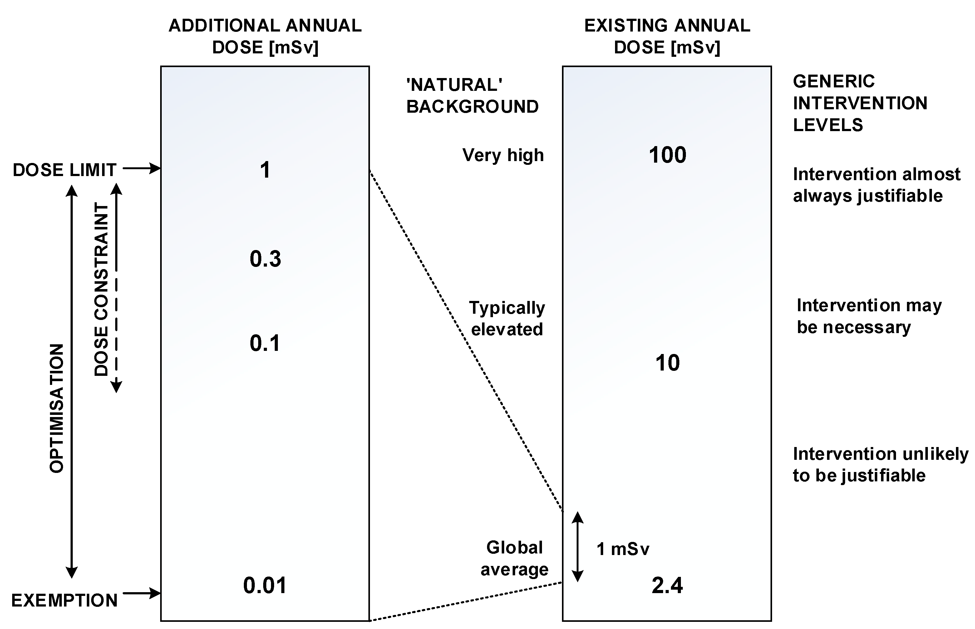
Figure 3 shows a perspective on the recommended levels for the individual dose restrictions in terms of additional annual dose can be gained by presenting them vis à vis values of existing annual doses due to natural background radiation [
24].
For the existing annual dose of natural radiation, the average value is 2.4 mSv, if this value is from 2.4 mSv to 10 mSv, then the intervention is not needed, but if it is higher than 10 mSv, then actions have to be applied.
Secondary standards
According to several Vietnamese standards (Vietn. Standard), the limiting concentration is the highest concentration of radioactive material in a volume unit of drinking water or breathing air for the subjects, so that the annual infiltration of radioactive materials into the body does not exceed the regulated limited threshold [
19].
Table 8 compiles the limiting radioactivity of some main elements which penetrate into the human body by the digestive tract and by inhalation.
Total of alpha radioactivity (α) is ≤0.1 Bq/L (according to QCVN 08:2008/BTNMT).
Total of beta radioactivity (β) is ≤1.0 Bq/L (according to QCVN 08:2008/BTNMT).
The radon concentration limit in the air where new houses are being built is ≤100 Bq/m3 and for using existing buildings, ≤200 Bq/m3 (according to TCVN 7889:2008).
The gamma dose rate of outdoor radiation does not exceed 0.3 μSv/h (according to NRB-96).
Radioactivity in the flora sampling ≤ 0.2 mSv per year (according to NRB-96).
When all of the radionuclides are concurrently present in drinking water and food, the total condition must be satisfying the following expression:
where:
Ai is the specific activity of the radionuclides in the sample; and
Aigh is the limited activity of radioactive nuclei.
3.3.2. Principle of Delineating Area Contaminated by Radiative Environment
Delineating expected area contaminated by natural radiation
Expected area contaminated by natural radiation happens when it satisfies one of following conditions [
26]:
An area has a total of equivalent radiation dose of >10.0 mSv/year;
An area has a radon concentration of >200.0 Bq/m3;
An area with a screening rate of >0.6 μSv/h, delineating an area with a total equivalent radiation dose of >7.0 mSv/year;
Total of alpha activity of >0.1 Bq/L water, or total of beta activity of >1.0 Bq/L water;
Radioactivity in the soil of >370.0 Bq/kg;
Radioactivity in the flora samples of >0.2 mSv/year.
Delineating controlled area contaminated by natural radiation
Controlled area contaminated by natural radiation happens when it has one of following conditions [
26]:
An area with an equivalent radioactive dose of gamma of >0.3 μSv/h, which equals to a total equivalent radioactive dose of >7.0 mSv/year;
An area with the radon concentration of >100.0 Bq/m3.
3.3.3. Local Definition of the Radioactive Areas in the Namxe Rare Earth Region
Based on the threshold values above, two areas in the Namxe ore deposit region were defined: A region of actual high radioactive contamination, exceeding several limit values, and a region with elevated radioactivity, where special control and monitoring efforts should be applied to (
Figure 2).
The area of natural radioactive contamination extends from the South, according to the Namxe stream to the North of Namxe deposit, with an area of 14.33 square kilometers, covering the whole area of the Namxe rare earth deposit and the villages Mau, Mo, Pa Chai, and Bo Cha. In this area, people are advised not to move to or settle permanently.
The natural radioactive control area is covering the area of natural radioactive contamination with an additional area of 8.33 square kilometers.
4. Conclusions
Several methods were applied to monitor the premining state of an area surrounding the Nam Xe rare earth deposit. The analytical work included air, soil, water, and crop samples and their activity due to the incorporation of radioactive elements such as Th, Rn, and K.
Analysis results of radioactivity from floras on the Namxe deposit area showed that staple food, planted in the vicinity of the area, has included radioactive active contents in high doses. The samples had higher Hd concentrated in the North Namxe region, village of Mau, and the area directly above the rare earth ore bodies.
The results presented in this study are the basis for monitoring the environmental impact of planned mine work in the near future, but may have a direct influence on the inhabitants in the area, with recommendations on the current agriculture.
Author Contributions
Conceptualization, writing—original draft, Q.V.P.; methodology, P.N. and T.H.; formal analysis, T.T.D. and D.H.T.
Funding
This research was funded by the project with the title of “Cooperative research of the mineral characterization, the suggestion of the sustainable processing strategies and the orientation of reasonable mining methods and environmental protection for the Namxe rare earth deposits in Laichau Province, Vietnam.” Code NDT-02.GER/15.
Acknowledgments
We would like to thank the Ministry of Science and Technology of Vietnam (MOST) and German Ministry of Education and Research (BMBF) for administrative support. We are also grateful to the managers, colleagues of the Hanoi University of Mining and Geology, Helmholtz Institute Freiberg for Resource Technology (HIF), Vietnam Geological Division of Radioactive and Rare Minerals (GDRRM), Hunghai Group (HHG), the People’s Committee of Laichau province, Phongtho district, Namxe commune, and SinSuoiHo border station, who cooperated and assisted in the implementation of the study. We are very thankful that Robert Moeckel at the HIF is reading and spelling this manuscript.
Conflicts of Interest
The funders had no role in the design of the study; in the collection, analyses, or interpretation of data; in the writing of the manuscript, or in the decision to publish the results.
References
- Heinig, T.; Burisch, M.; Möckel, R.; Phan, Q.V.; Ebert, D. Gutzmer: Mineralogy, Petrography and Genesis of REE Bearing Carbonatite Dykes, NamXE Deposit, Vietnam; (in preparation)
- Dzien, D.V. Rare Earth Deposits. In Geology and Mineral Resources of Vietnam; Xinh, L.T., Tri, T.V., Dzung, D.H., Dzung, N.T., Chien, L.T., Chau, D.M., Hai, T.H., Eds.; Mineral Develop-ment Co: Hanoi, Vietnam, 1990; pp. 144–147. [Google Scholar]
- Hedrick, J.B. Rare Earths. USGS Minerals Yearbook. 1996. Available online: http://minerals.usgs.gov/minerals/pubs/commodity/rare_earths/740496.pdf (accessed on 6 August 2013).
- Bui, T.H.; Trinh, D.H.; Nguyen, P. Overview of rare earth in Vietnam. Geol. J. Ser. A 2010, 447–456. [Google Scholar]
- People’s Committee of Nam Xe commune (2015): Report on the socio-economic development in order to ensure national defense and security in 2015 and the key tasks of socio-economic development to ensure national defense and security in 2016. No. 215/BC-UBND. Nam Xe, 2015.
- Trinh, D.H.; Nguyen, P. Develop a methodology for investigating and assessing the environment related to toxic minerals on the basis of existing equipment in Vietnam. J. Geol. Ser. A 2013, 30–38. [Google Scholar]
- Vietnam Map. Available online: http://www.vietnamtours.ws/Map.html (accessed on 28 August 2019).
- LaiChau Map. Available online: http://vietnamtravels.vn/Vietnam-travel-information/Lai-Chau.htm (accessed on 28 August 2019).
- Paiva, I.; Marques, R.; Santos, M.; Reis, M.; Prudêncio, M.I.; Waerenborgh, J.C.; Dias, M.I.; Russo, D.; Cardoso, G.; Vieira, B.J.C.; et al. Naturally occurring radioactive material and risk assessment of tailings of polymetallic and Ra/U mines from legacy sites. Chemosphere 2019, 223, 171–179. [Google Scholar] [CrossRef] [PubMed]
- Ryabukhin, Y.S. Radiation Safety Standards (NRB-96). Meditsinskaya Radiologiya i Radiatsionnaya Bezopasnost 1997, 42, 70–73. [Google Scholar]
- National Commission for Sanitary Inspection of Russian Epidemiology. Radiation Safety Standards (NRB-99); Minzdrav Rossii: Moscow, Russia, 1999.
- Nguyen, V.N. To Study the Scientific Basis to Determine the Level of Environmental Pollution of Natural Radioactive Sources in Order to Develop Technological Process for Detailed Assessment of Radioactive Contamination Areas; Archives in Science and Technology Information Center; Ministry of Science and Technology of Vietnam: Hanoi, Vietnam, 2009.
- Dao, V.T.; Nguyen, P.D.; Vu, H.L.; Chu, V.N.; Vu, V.N.; Bui, V.T.; Nguyen, T.T.; Tran, B.T. Temporary Guidance on Environmental Geological Survey and Geological Disasters; Archives in Geological Archives Information Center: Hanoi, Vietnam, 2004. [Google Scholar]
- Trong, T.B. Investigating the State of the Radioactive Environment, Its Ability to Influence and Remedial Measures on Some Radioactive Mines, Mines Containing Radioactivity in Lai Chau, Cao Bang and Quang Nam; Archive in Geological Archives Information Center: Hanoi, Vietnam, 2003. [Google Scholar]
- TCVN 9414:2012: Investigation, Assessment of Geological Environment—Gamma Method. Available online: https://vanbanphapluat.co/tcvn-9414-2012-dieu-tra-danh-gia-dia-chat-moi-truong-phuong-phap-gamma (accessed on 28 September 2019).
- TCVN 9416: 2012: Investigation, Assessment of Geological Environment—Radioactive Air Method. Available online: https://vanbanphapluat.co/tcvn-9416-2012-dieu-tra-danh-gia-dia-chat-moi-truong-phuong-phap-khi-phong-xa (accessed on 28 September 2019).
- TCVN 9419:2012: Investigation, Evaluation and Exploration of Minerals—Gamma Spectrometric Method. Available online: https://vanbanphapluat.co/tcvn-9419-2012-dieu-tra-danh-gia-tham-do-khoang-san-phuong-phap-pho-gamma (accessed on 28 September 2019).
- TCVN 7538-1:2006 (ISO 10381-1:2002): Soil Quality—Sampling—Part 1: Guidance on the Design of Sampling Programmes. Available online: https://vanbanphapluat.co/tcvn-7538-1-2006-chat-luong-dat-phan-1-huong-dan-lap-chuong-trinh-lay-mau (accessed on 28 September 2019).
- TCVN 7889:2008: Natural Radon activity in Buildings-Levels and General Requirements of Measuring Methods. Available online: http://luattrongtay.vn/ViewFullText/Id/b294e192-e2fe-440e-86df-bac4c4bbd75b (accessed on 28 September 2019).
- TCVN 6663-1:2011 (ISO 5667-1:2006): Water Quality—Sampling—Part 1: Guidance on the Design of Sampling Programmes and Sampling Techniques. Available online: https://www.iso.org/obp/ui/#iso:std:iso:5667:-1:ed-2:v1:en (accessed on 28 September 2019).
- International Atomic Energy Agency (IAEA). Technical Reports Series No.295. Measurement of Radionuclides in Food and the Environment. A Guidebook. Available online: https://www.iaea.org/publications/1398/measurement-of-radionuclides-in-food-and-the-environment (accessed on 28 September 2019).
- Phuong, N. Study on the Methodology for Environmental Impact Assessment and Integration of Mineral Resource Protection with Environmental Protection of Uranium and Rare Earth Mines in Northwest of Vietnam; Bulletin No. B2001-36–13; Library of Hanoi University of Mining and Geology: Hanoi, Vietnam, 2003. [Google Scholar]
- QCVN 08-MT:2015/BTNMT. National Technical Regulation on Surface Water Quality; Socialist Republic of Vietnam: Hanoi, Vietnam, 2015. [Google Scholar]
- ICRP Publication 82. Protection of the Public in Situations of Prolonged Radiation Exposure; Elsevier Science Ltd.: Amsterdam, The Netherlands, 2000. [Google Scholar]
- ICRP Publication 103. The 2007 Recommendations of the International Commission on Radiological Protection; Elsevier Science Ltd.: Amsterdam, The Netherlands, 2007. [Google Scholar]
- Nguyen Van Nam. Research on the Scientific and Practical Basis for Determining the Level of Natural Irradiation Potentially Harmful to Human Beings; Project of Ministry Level; Archives of Science and Technology Information Center, Ministry of Science and Technology Vietnam: Hanoi, Vietnam, 2011.
© 2019 by the authors. Licensee MDPI, Basel, Switzerland. This article is an open access article distributed under the terms and conditions of the Creative Commons Attribution (CC BY) license (http://creativecommons.org/licenses/by/4.0/).

