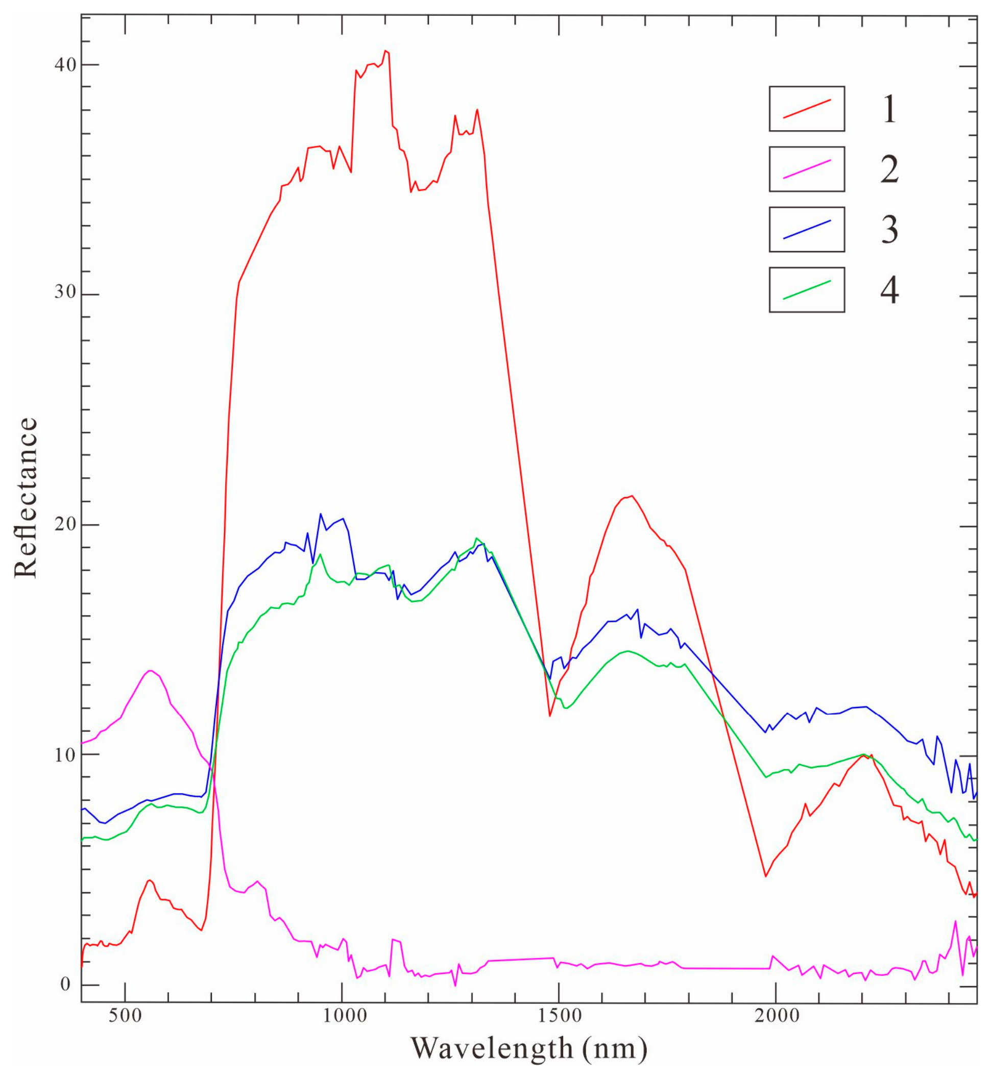
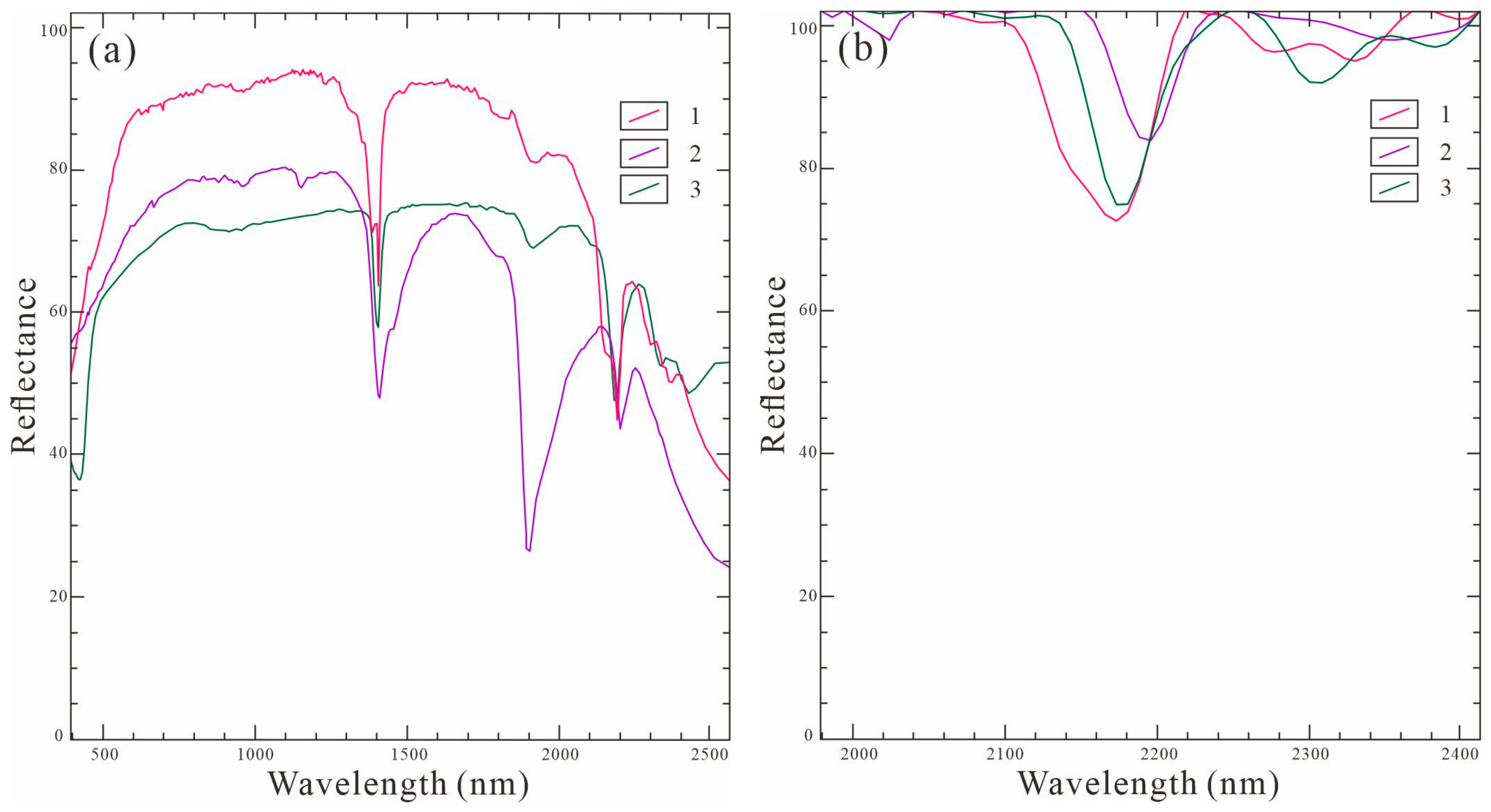
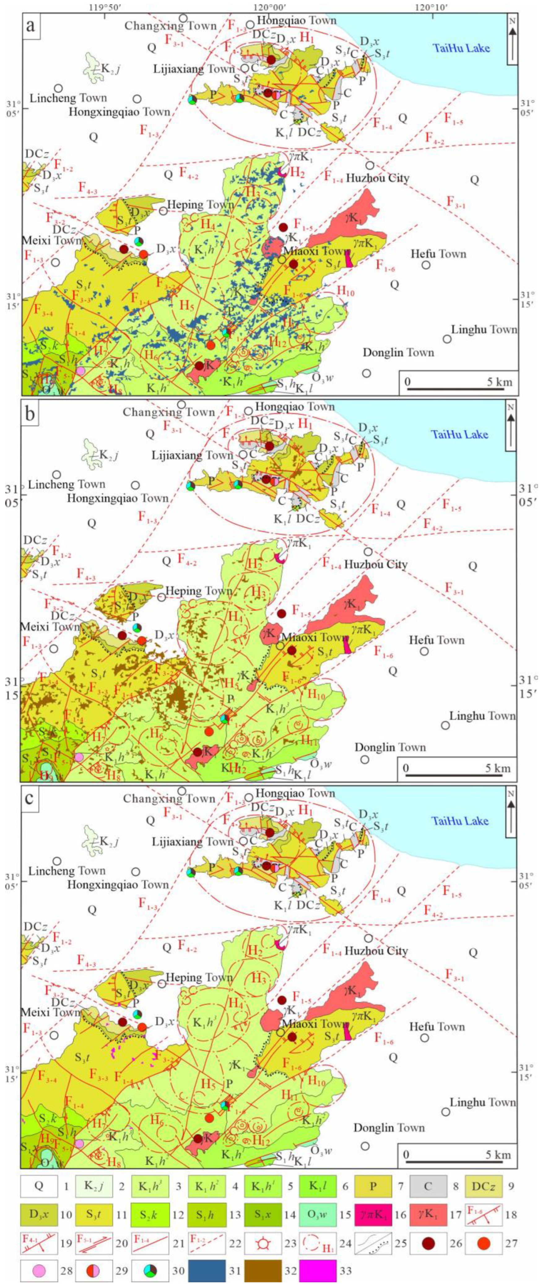
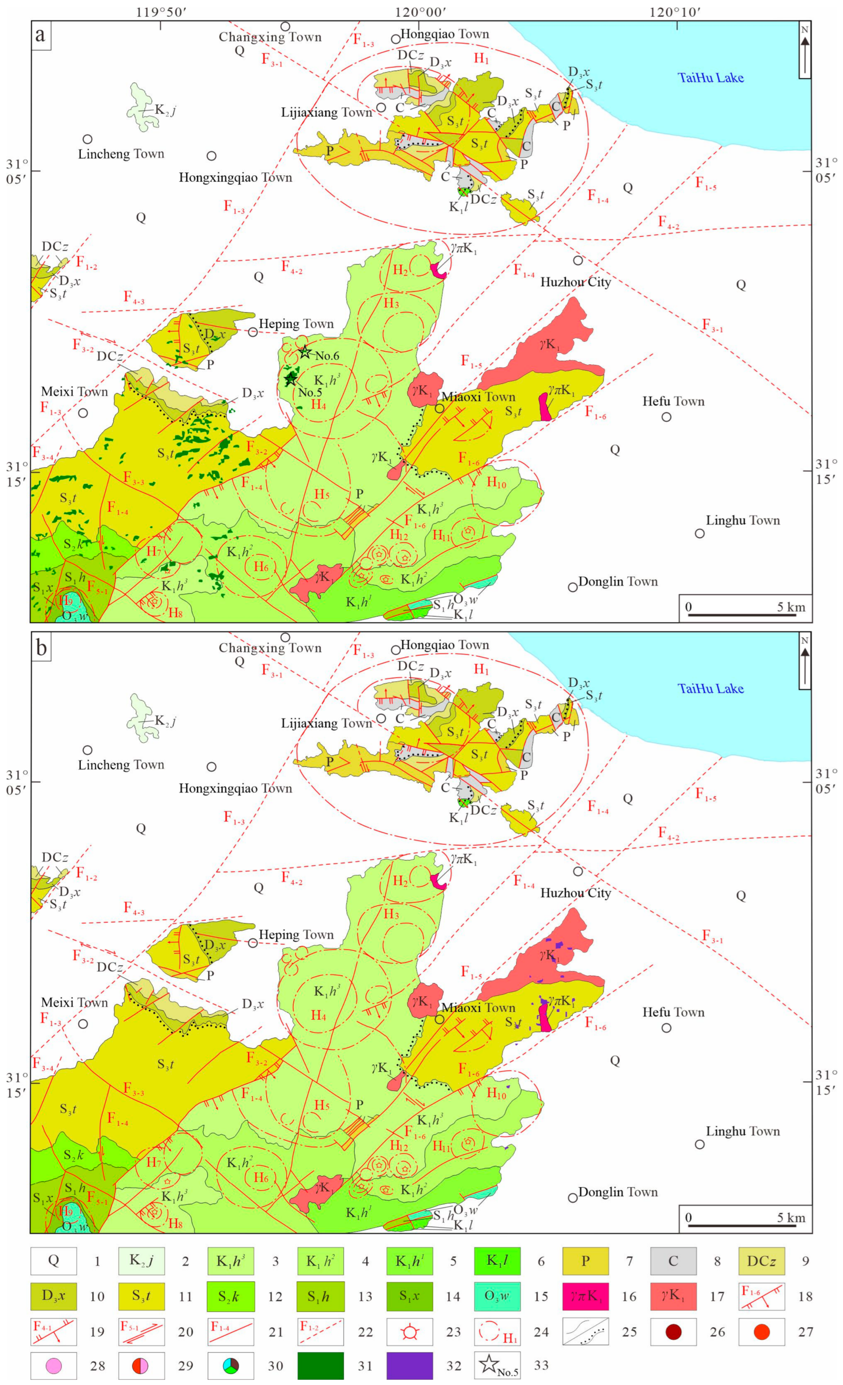
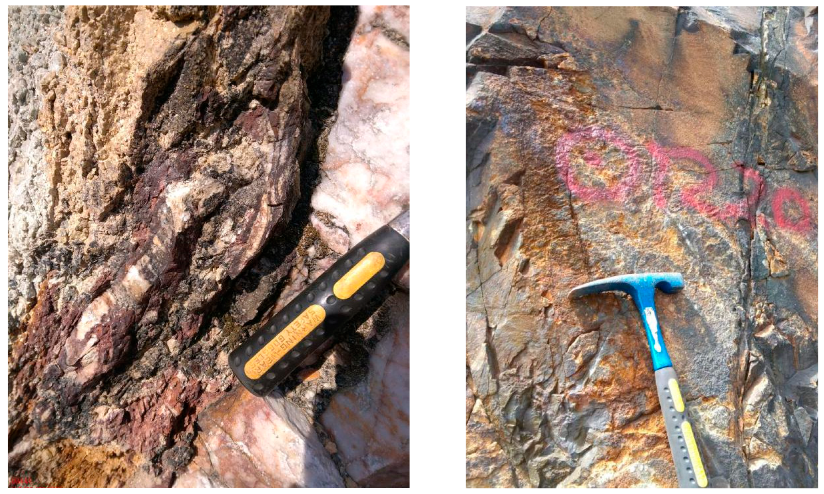
Extraction of Alteration Minerals and Prospecting Prediction in Vegetated Regions Based on GF-5B Hyperspectral Data: A Case Study of the Huzhou Region, Zhejiang Province, China
 , ,
, ,
Abstract
1. Introduction
2. Regional Geology and GF-5B Hyperspectral Data
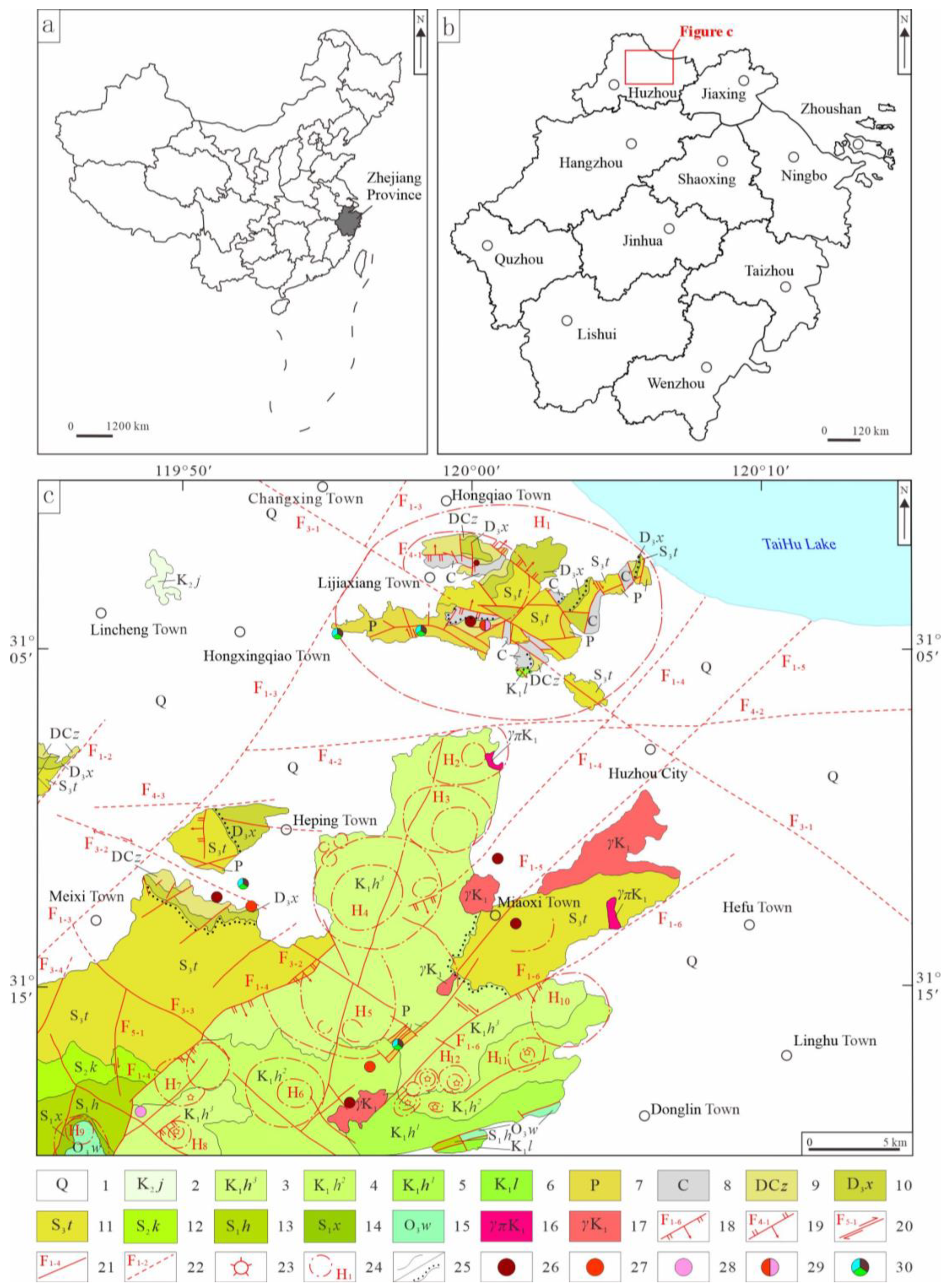
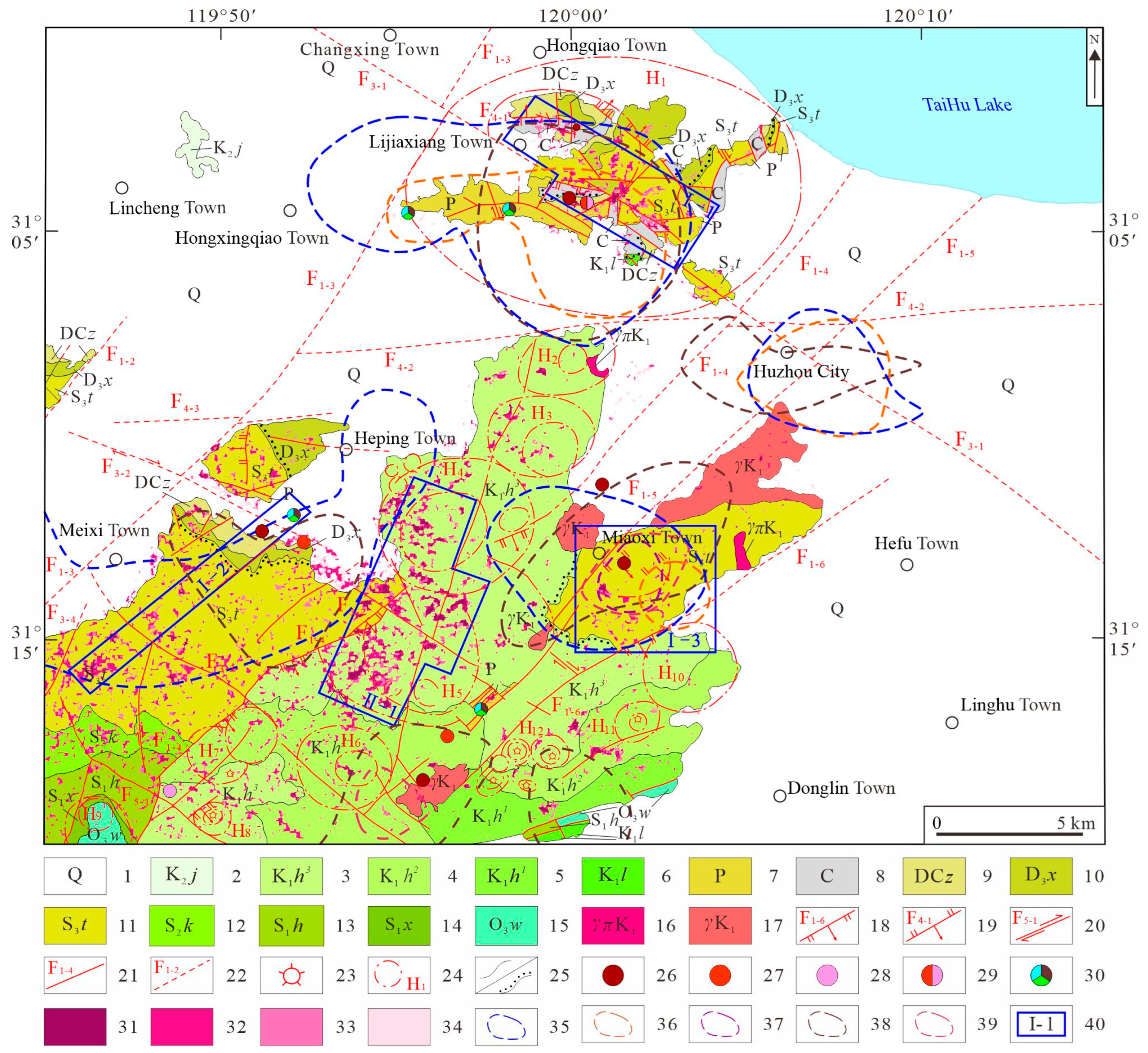
2.1. Regional Geological Characteristics
2.2. GF-5B Hyperspectral Data Used
3. Methods
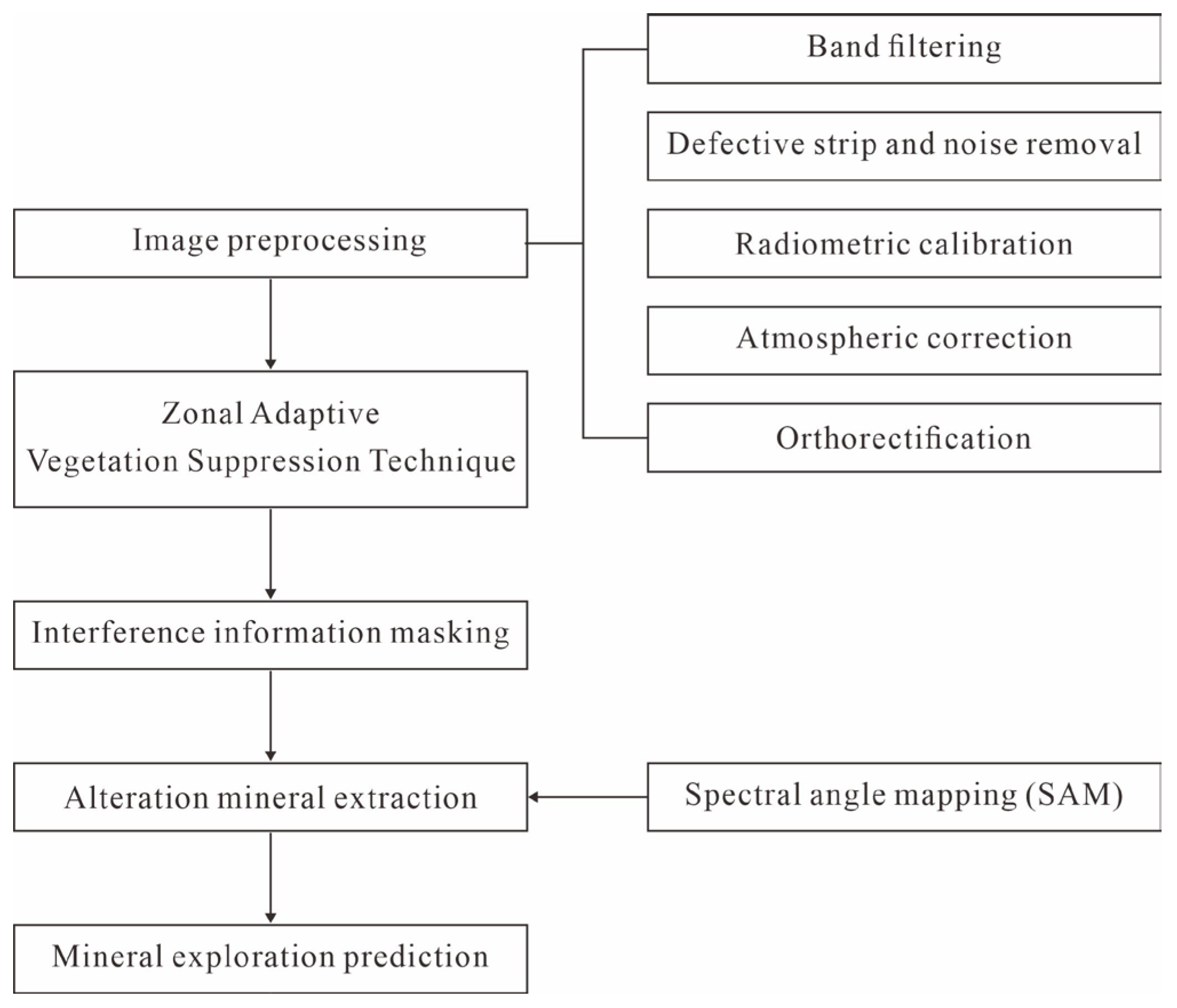
3.1. Process for Extracting Alteration Minerals
3.2. Zonal Adaptive Vegetation Suppression Technique
- (1)
- Calculate the Normalized Difference Vegetation Index (NDVI). This index is calculated using the near-infrared and red spectral bands. This index is highly sensitive to the growth status of green vegetation, making it effective for monitoring vegetation growth and estimating vegetation cover. To facilitate land cover classification and segmented interval indexing, the original floating-point range of NDVI [−1, 1] is linearly stretched to the integer range [0, 255]. However, when actually used in the calculation of the vegetation contribution separation formula (1), the original floating-point NDVI values are still employed.
- (2)
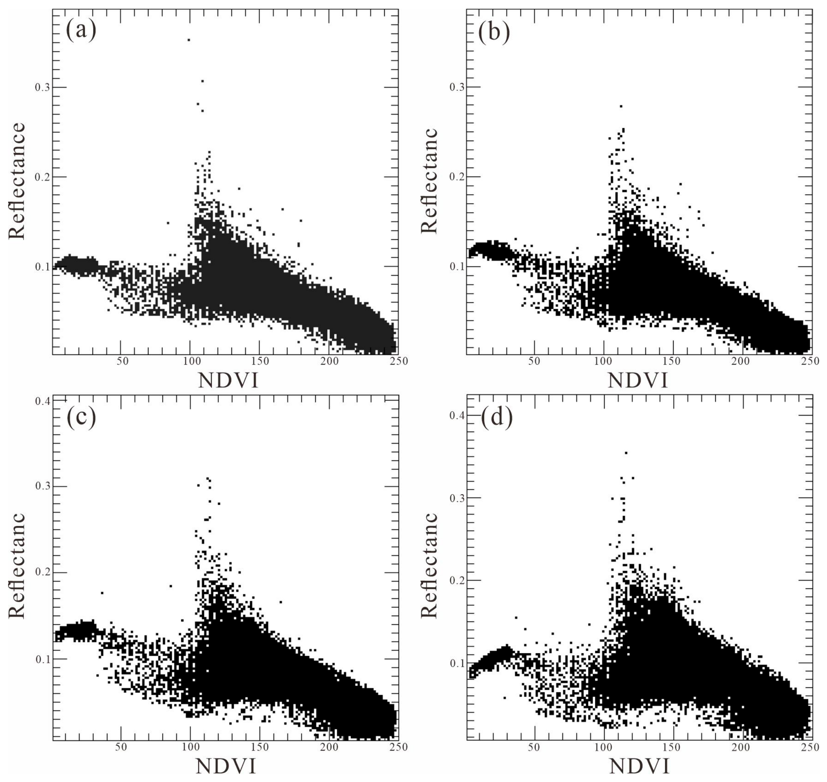
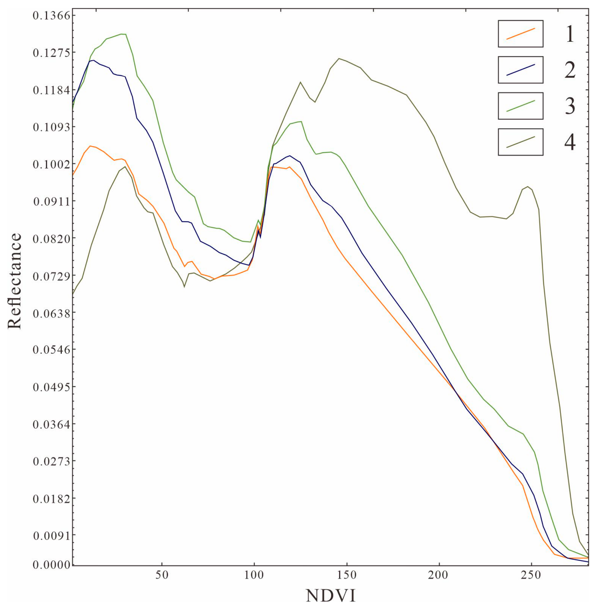
- Analyze the relationship between reflectance in each band and NDVI. Perform scatter plot analysis on each band of the preprocessed hyperspectral imagery against the NDVI imagery. For each band, statistically analyze the distribution relationship between the reflectance of each pixel and its corresponding NDVI value, and generate scatter plots. To eliminate the interference of outliers in the imagery on the overall trend analysis, this study employs a mean-based fitting method with percentile filtering to perform curve fitting on the multivariate scatter data. First, the 25th and 75th percentiles of the reflectance values are calculated to define the valid data range. Only the image reflectance data falling between the 25th and 75th percentiles are retained, thereby excluding outliers and extreme discrete points outside this range. Next, for each NDVI value, the arithmetic mean of its corresponding reflectance values is calculated. The mean points at each NDVI location are then connected sequentially to form a mean curve, which visually reflects the overall trend of the main data set. This fitted curve reveals the general trend of reflectance variation with vegetation cover, providing a basis for subsequent segmented smoothing processing.
- (3)
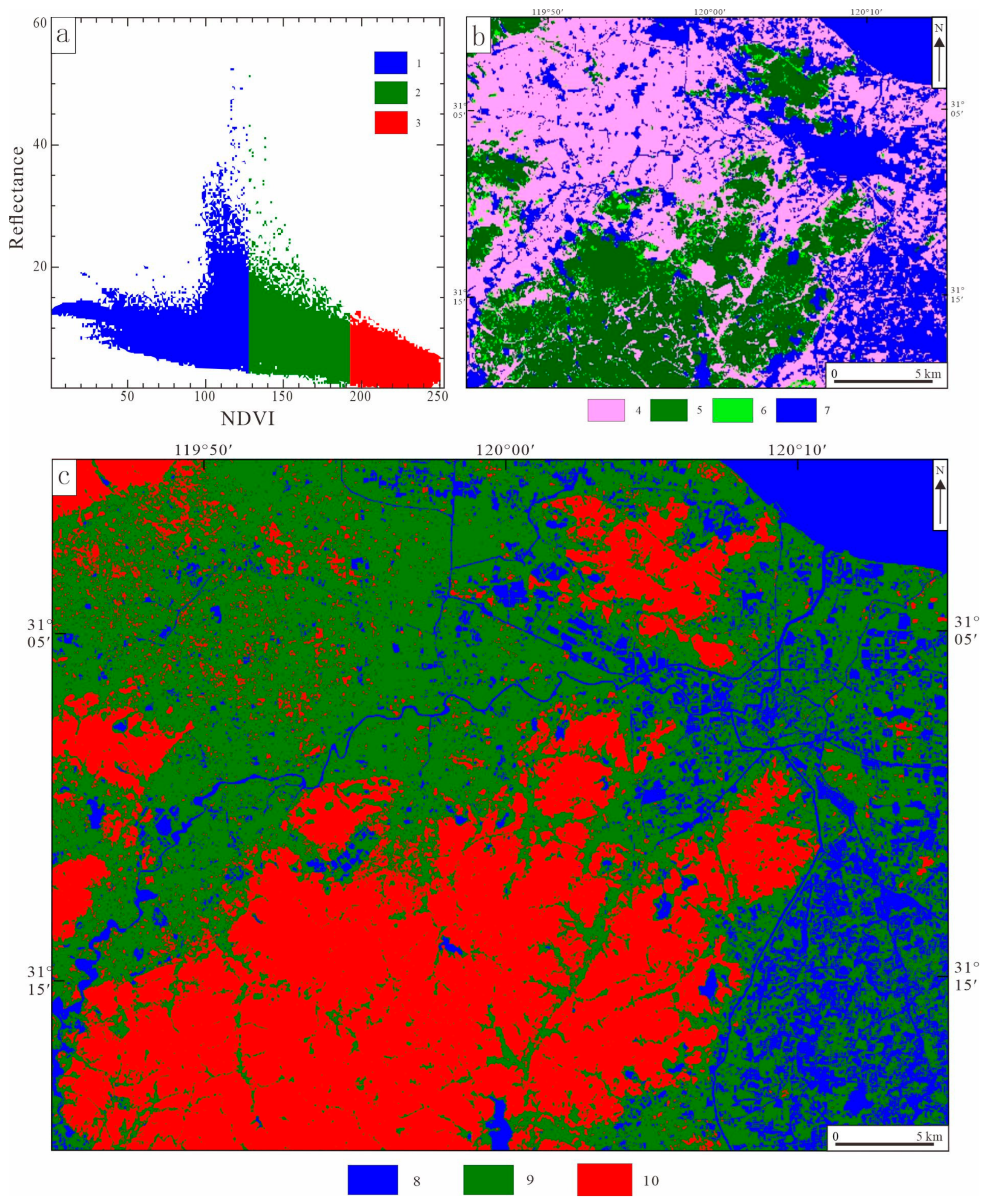
- Classify land cover based on NDVI. Based on the mean and standard deviation of NDVI, and in conjunction with the distribution patterns observed in scatter plots and fitted curves, the image is divided into regions corresponding to different land cover types: areas where NDVI > (mean + 0.5 × standard deviation) are classified as vegetation; areas where NDVI < 0 are classified as water bodies, clouds, and shadows; areas where 0 < NDVI < (mean + 0.5 × standard deviation) are classified as Quaternary deposits and other land cover types. In southern vegetation-covered regions, where land cover types are complex and diverse and spectral values are highly dispersed, land cover classification should emphasis overall consistency and avoid excessive subdivision.
- (4)
- Calculate the segmented smoothed values. To reduce random errors in the fitted curves, this study further smooths the fitted curves for each band using a method that combines median filtering with local weighted averaging. First, median filtering is applied to perform preliminary smoothing of the fitted curves. As a nonlinear smoothing technique, median filtering replaces the value at each point on the curve with the median of all values in that point’s neighborhood. This step effectively suppresses isolated noise points while preserving the edge features of the curve, thereby avoiding the blurring of transition zones between different land cover types caused by excessive smoothing. Building on this, segmented smoothing is further performed using the local weighted averaging method. This method divides the curve into several segments based on the distribution characteristics of land cover types. Within each segment, the values at each point on the curve are calculated using a weighted average based on the values of several neighboring points, with closer points assigned higher weights, thereby achieving refined smoothing within a local area. After these two processing steps, we obtain smoothed curves showing how reflectance varies with NDVI values for each band. Fluctuations within each NDVI interval have been effectively suppressed, and random noise caused by changes in vegetation cover has been largely eliminated. Finally, for each NDVI interval, we calculate the average reflectance of all corresponding points on the smoothed curve to obtain the segmented average value for that band within that interval (Ptarget).
- (5)
- Smooth segmented curves and separate vegetation contributions. The core of this step lies in quantitatively separating and removing the spectral contribution of vegetation to achieve vegetation suppression, thereby highlighting the spectral characteristics of target objects such as rocks and soil. Specifically, for each pixel, based on the bin in which its NDVI value falls, the corresponding flat-field value for that band is selected. The original reflectance value is then adjusted as a ratio to separate the spectral contribution of vegetation, yielding a new pixel value. Equation (1) for separating the vegetation contribution is as follows:where represents the new image reflectance value, represents the original image reflectance value, NDVI represents the Normalized Difference Vegetation Index, and Ptarget represents the flat-field value.
3.3. SAM Method
4. Image Preprocessing
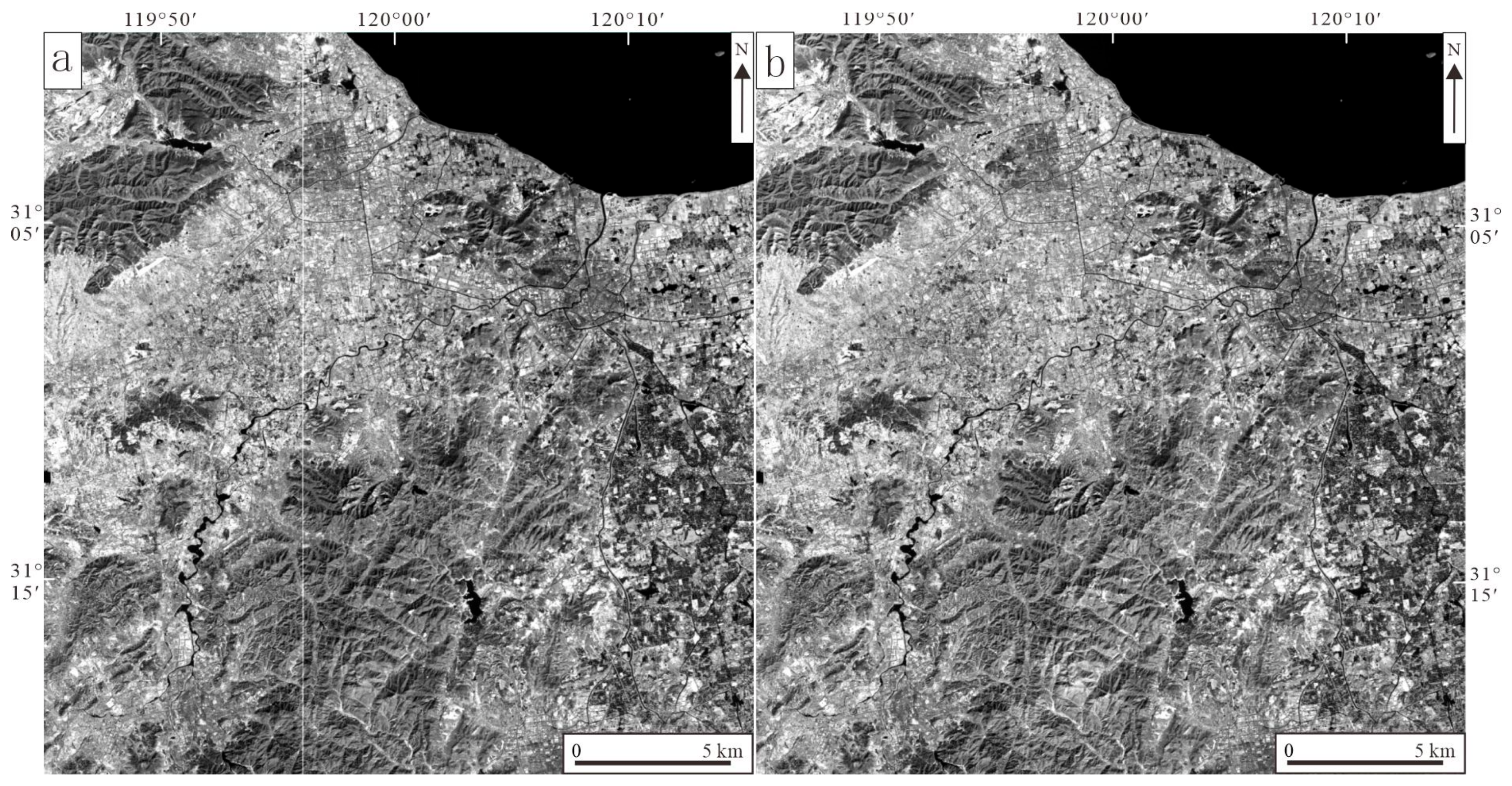
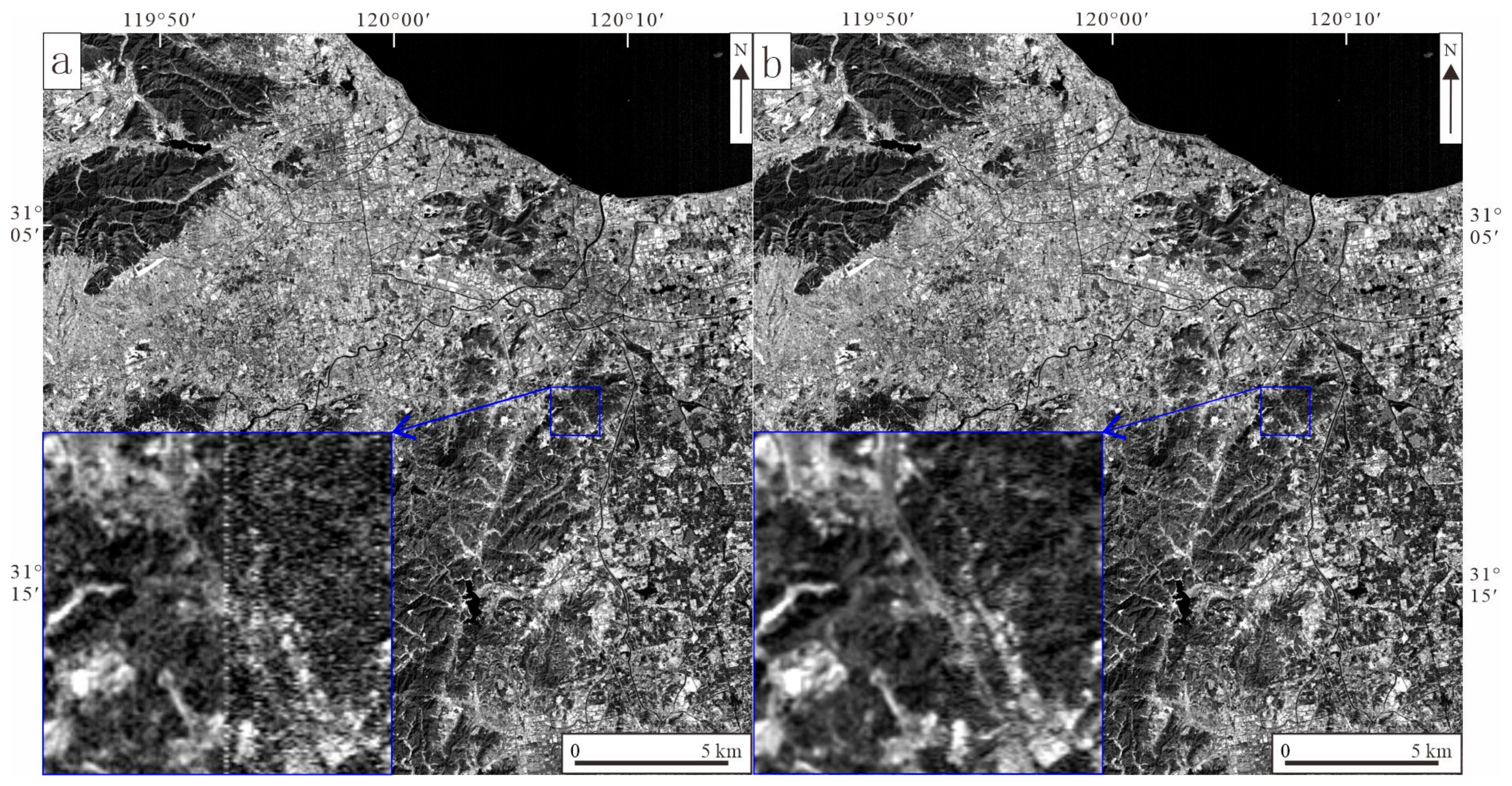
4.1. Basic Preprocessing
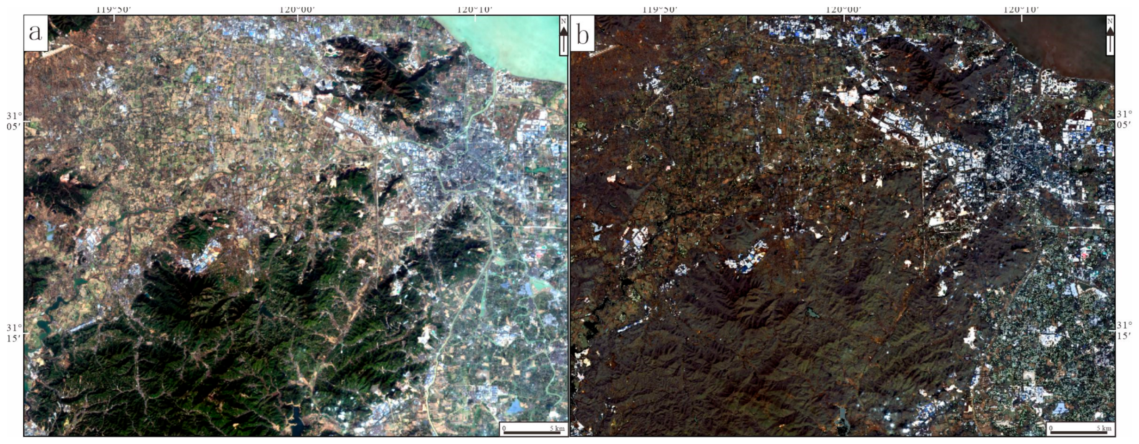
4.2. Zonal Adaptive Vegetation Suppression Technique Processing
- ndvi = (nir_band − red_band) / (nir_band + red_band + 1e-10)
- return ndvi
- def vegetation_suppression(img, red_index, nir_index):
- red_band = img[red_index]
- nir_band = img[nir_index]
- ndvi = calculate_ndvi(red_band, nir_band)
- num_segments = 10
- segments = np.linspace(ndvi.min(), ndvi.max(), num_segments + 1)
- suppressed_img = np.zeros_like(img)
- for i in range(len(segments) − 1):
- mask = (ndvi >= segments[i]) & (ndvi < segments[i + 1])
- if np.any(mask):
- for b in range(img.shape[0]):
- segment_values = img[b][mask]
- if len(segment_values) > 0:
- mean_val = np.mean(segment_values)
- suppressed_img[b][mask] = img[b][mask] − mean_val + np.mean(img[b])
- else:
- suppressed_img[:, mask] = img[:, mask]
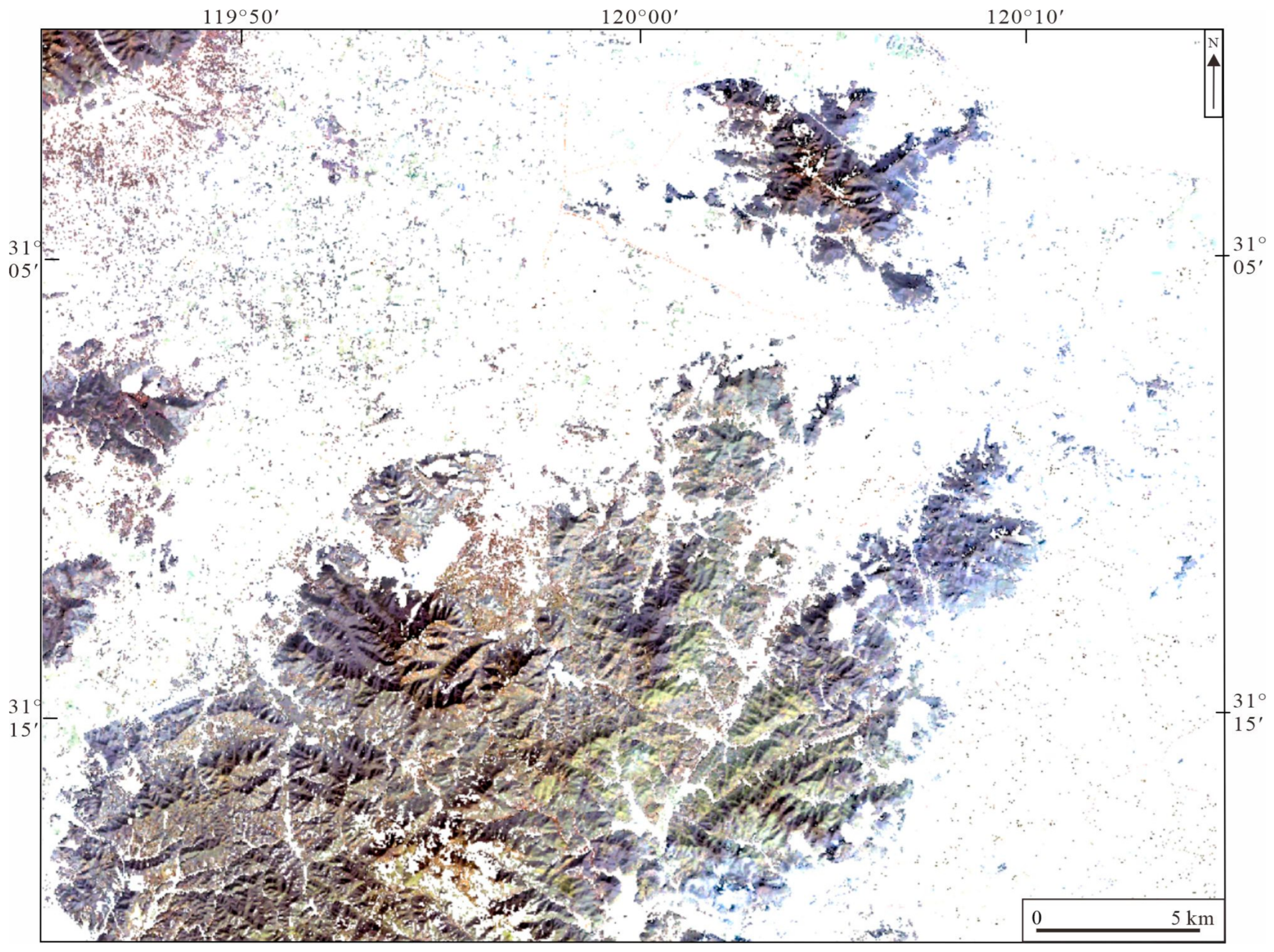
4.3. Interference Information Masking
- (6)
- Vegetation and Quaternary sediment masking
- (7)
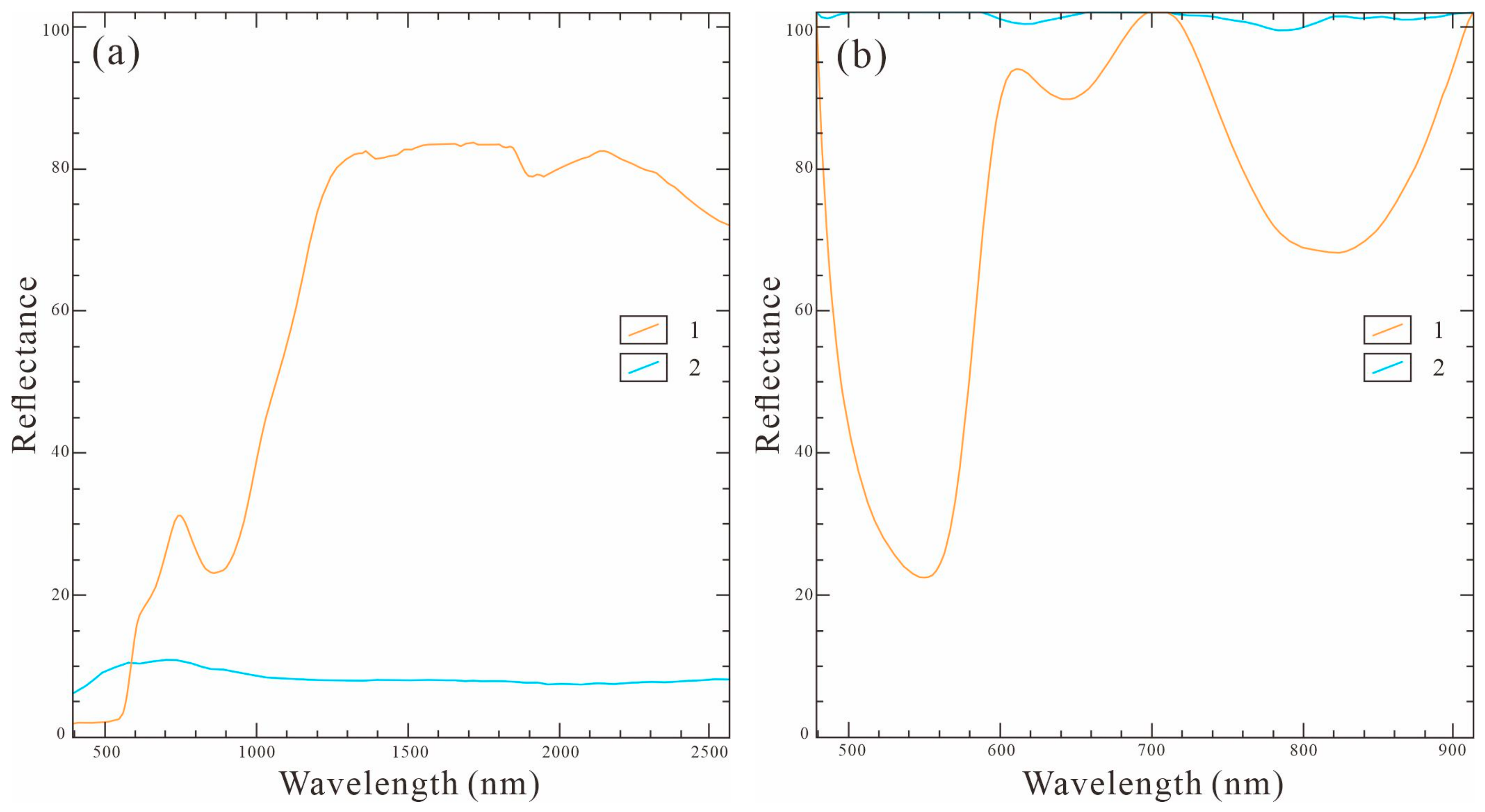
- Water bodies masking
5. Results
5.1. Extraction of Fe-Bearing Alteration Minerals
5.2. Extraction of Al-OH Type Alteration Minerals
5.3. Extraction of Mg-OH Type Alteration Minerals
6. Discussion
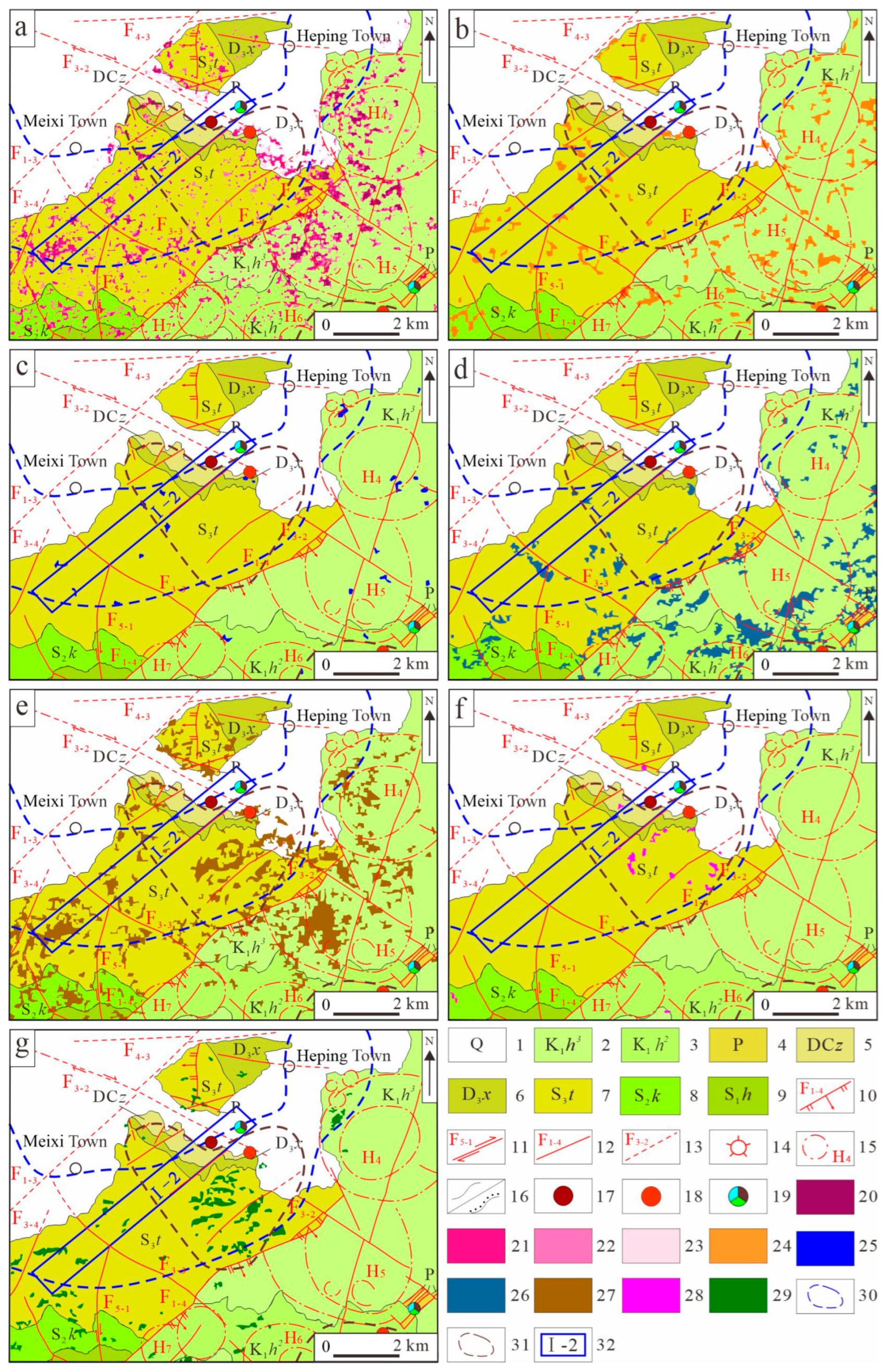
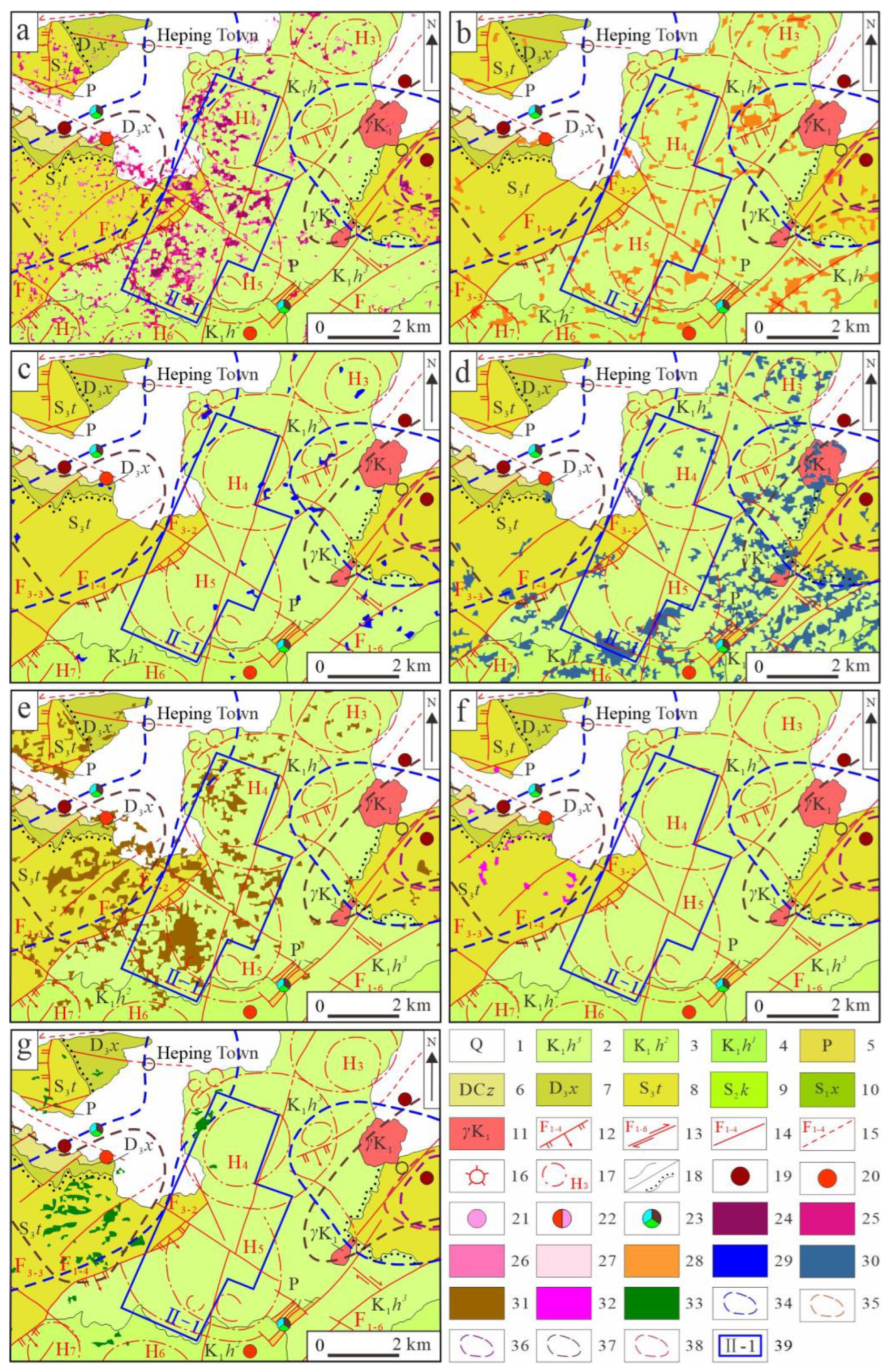
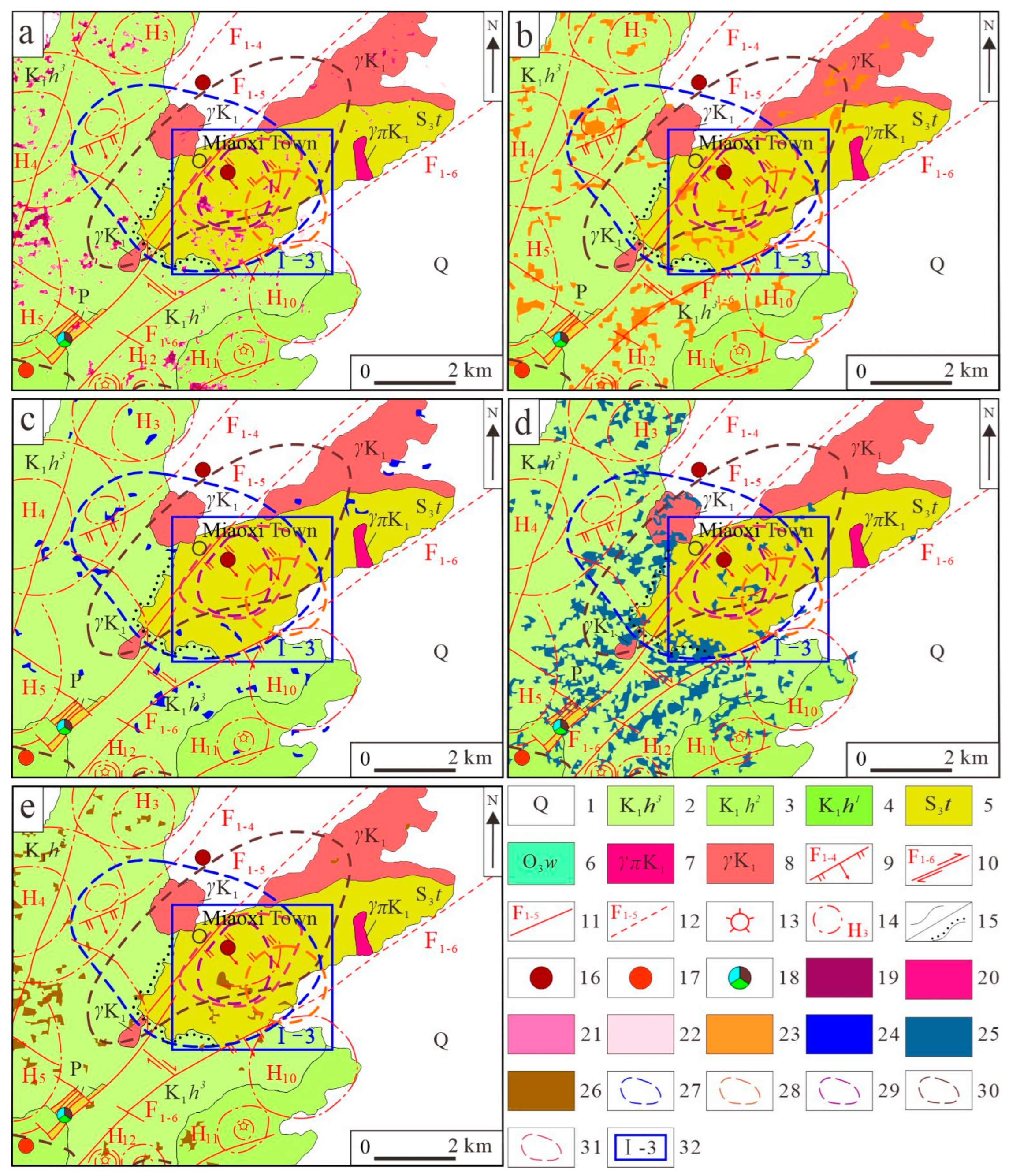
6.1. Analysis of the Distribution Characteristics of Alteration Minerals
- (1)
- Fe-bearing alteration minerals
- (2)
- Al-OH type alteration minerals
- (3)
- Mg-OH type alteration minerals
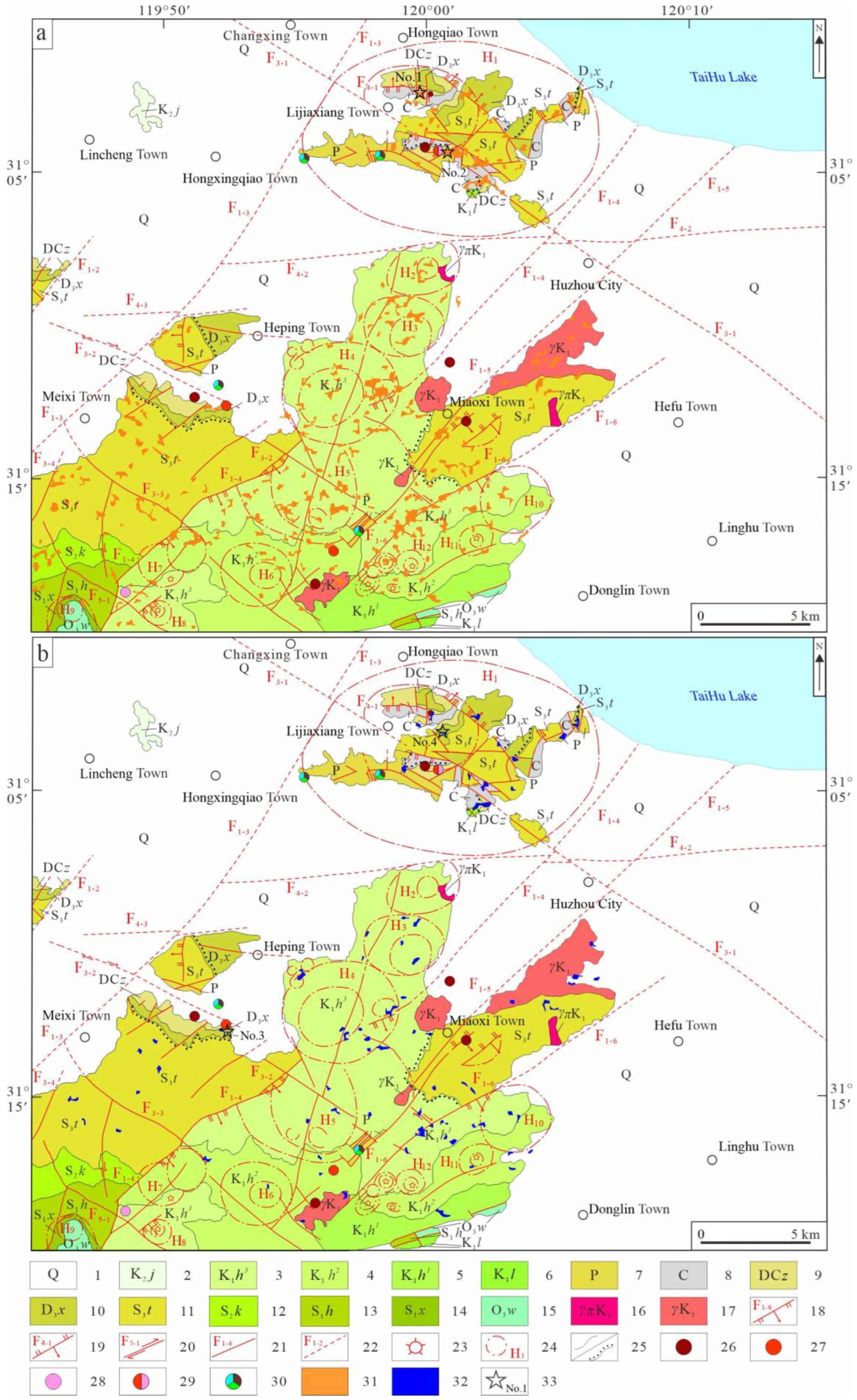
6.2. Prediction of Prospective Areas for Mineral Exploration
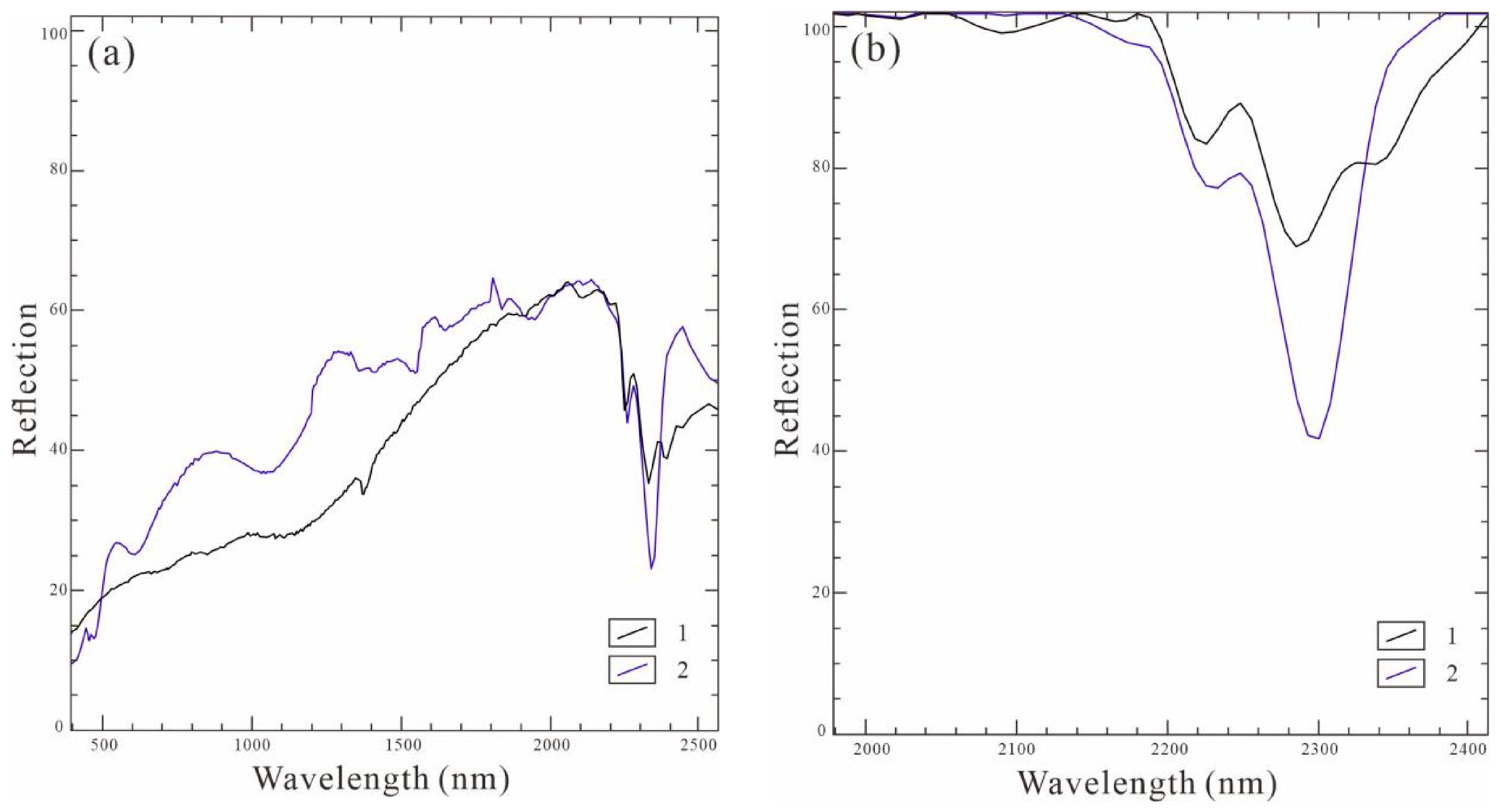
6.3. Methodology Evaluation and Discussion
7. Conclusions
- (1)
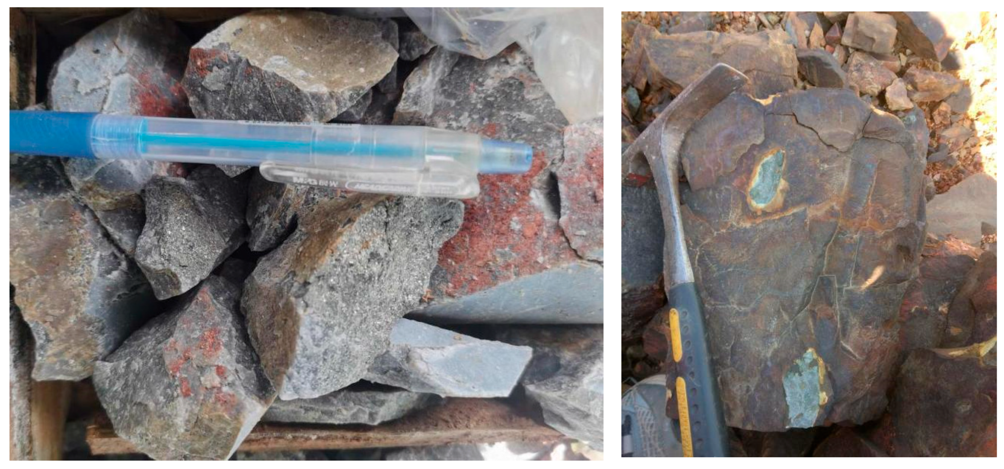
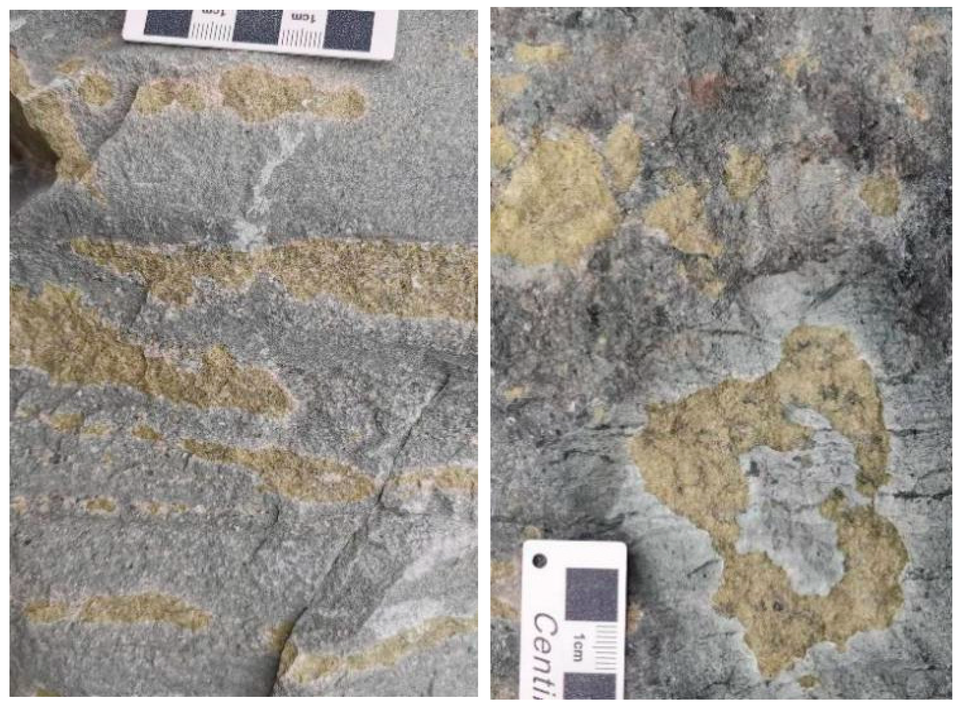
- To tackle the technical challenges posed by dense vegetation cover and weak spectral responses of alteration minerals in Huzhou, Zhejiang Province, China, we propose a zone-based adaptive vegetation suppression method incorporating piecewise spectral–statistical modeling. Developed through establishing segmented statistical correlations between multi-band reflectance characteristics and NDVI values, this technique demonstrates superior capability in suppressing vegetation masking effects while preserving diagnostic absorption features of subsurface alteration minerals, enhancing alteration mineral detection accuracy compared to traditional methods under equivalent vegetated conditions. The proposed methodology has been rigorously validated through field sampling and hyperspectral core scanning datasets from the study area.
- (2)
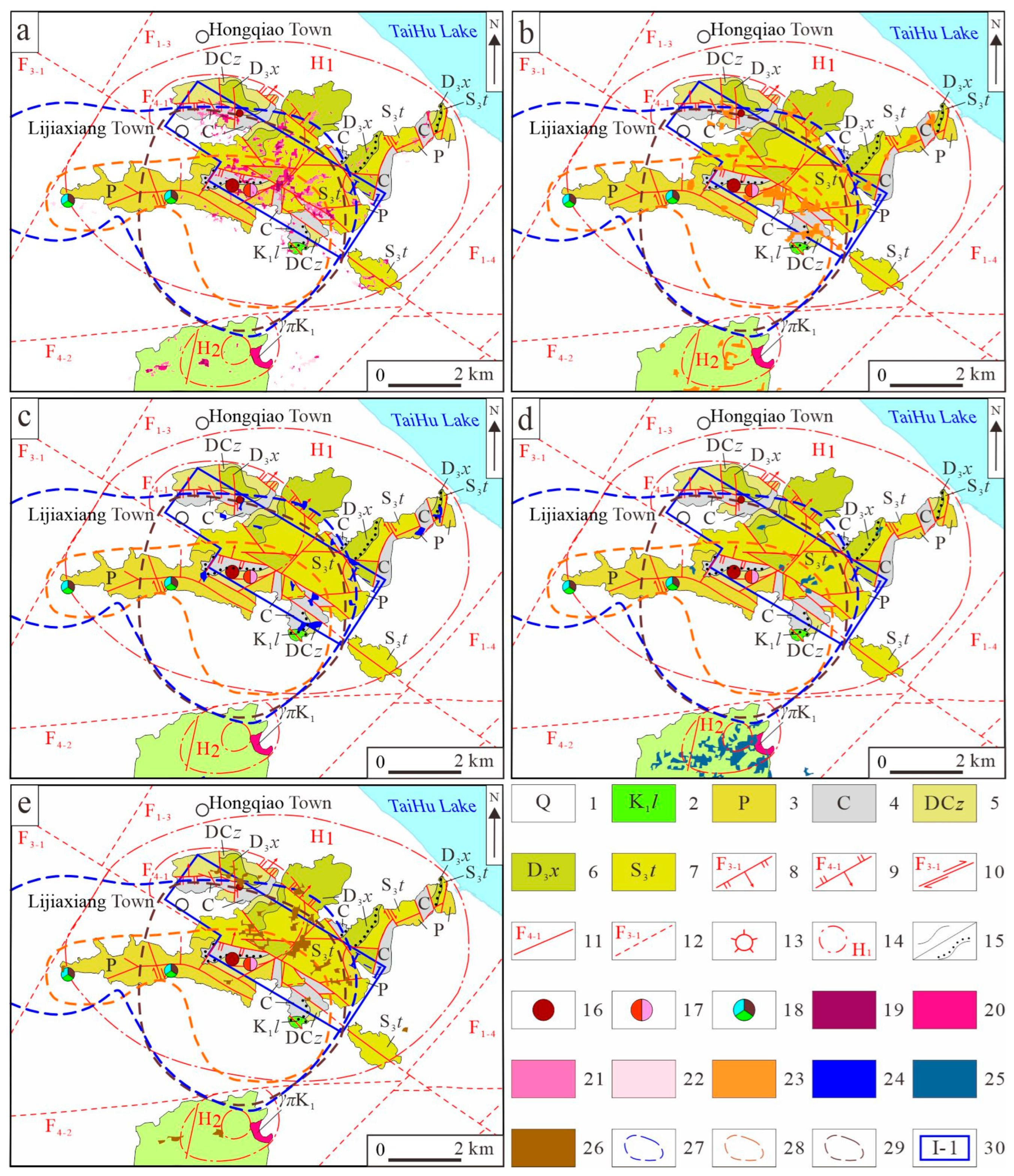
- Utilizing the Advanced Hyperspectral Imager (AHSI) onboard China’s GF–5B satellite combined with the Spectral Angle Mapper (SAM) algorithm, we systematically identified seven distinct alteration mineral species grouped into three genetic categories within the Moganshan volcanic basin: Fe-bearing alteration phases (hematite, pyrite), Al–OH alteration assemblages (kaolinite, montmorillonite, muscovite), and Mg–OH type alteration associations (chlorite, epidote). Spatial analysis reveals that Fe-bearing phases exhibit predominant alignment with NE-striking fault systems and Mesozoic volcanic basin boundaries, while Al–OH-dominated assemblages show preferential development in metasomatic aureoles surrounding Cretaceous granitoid plutons. Notably, Mg–OH-associated minerals demonstrate pronounced concentration at interfaces between Paleozoic carbonate platforms and concealed granitic intrusions. These spatial correlations underscore the decisive control exerted by syn-magmatic faulting episodes and multi-stage hydrothermal fluid circulation on alteration zonation patterns.
- (3)
- Analysis of alteration mineral superimposition revealed anomalous zones characterized by the coexistence of up to four types of alteration minerals across the study area. Spatial clustering occurs predominantly at NE-trending and NW-trending fault intersections, along intrusive contact zones, and within annular structural margins, demonstrating strong tectonic-magmatic control. Combined with the spatial distribution characteristics of known deposits and occurrences, this confirms that zones with superimposed alteration minerals of multiple types are highly correlated with mineralization and can serve as important indicators for mineral exploration in this study area.
- (4)
- Through systematic integration of multi-source exploration datasets including alteration mineral assemblages, characteristics of lineament and annular structures, lithostratigraphic units, and geochemical element anomalies, four priority mineral exploration targets were delineated: Lijiaxiang Town, eastern Meixi Town, Miaoxi Town, and the central Moganshan Volcanic Basin.
Author Contributions
Funding
Data Availability Statement
Conflicts of Interest
References
- Carranza, E.J.M.; Hale, M. Mineral imaging with Landsat Thematic Mapper data for hydrothermal alteration mapping in heavily vegetated terrane. Int. J. Remote Sens. 2002, 23, 4827–4852. [Google Scholar] [CrossRef]
- Crosta, A.P.; De Souza Filho, C.R.; Azevedo, F.; Brodie, C. Targeting key alteration minerals in epithermal deposits in Patagonia, Argentina, using ASTER imagery and principal component analysis. Int. J. Remote Sens. 2003, 24, 4233–4240. [Google Scholar] [CrossRef]
- Alimohammadi, M.; Alirezaei, S.; Kontak, D.J. Application of ASTER data for exploration of porphyry copper deposits: A case study of Daraloo–Sarmeshk area, southern part of the Kerman copper belt, Iran. Ore Geol. Rev. 2015, 70, 290–304. [Google Scholar] [CrossRef]
- Gabr, S.S.; Hassan, S.M.; Sadek, M.F. Prospecting for new gold-bearing alteration zones at El-Hoteib area, South Eastern Desert, Egypt, using remote sensing data analysis. Ore Geol. Rev. 2015, 71, 1–13. [Google Scholar] [CrossRef]
- Bodeving, S.; Vasyukova, O.V.; Williams-Jones, A.E. Controls on the origin and evolution of wall-rock alteration at the Big Whopper Li-Cs-Ta pegmatite, Canada. Econ. Geol. 2025, 120, 689–714. [Google Scholar] [CrossRef]
- Liu, J.G.; Li, Z.Y.; Zhang, W.L.; Nie, J.T. Evolution of ore-forming fluids in the deep polymetallic mineralization in western Xiangshan uranium ore field, Jiangxi Province: Evidence from altered wall rocks. Acta Geol. Sin. 2026, 100, 202–222. [Google Scholar] [CrossRef]
- Cardoso-Fernandes, J.; Teodoro, A.C.; Lima, A. Remote sensing data in lithium (Li) exploration: A new approach for the detection of Li-bearing pegmatites. Int. J. Appl. Earth Obs. Geoinf. 2019, 76, 10–25. [Google Scholar] [CrossRef]
- Du, X.C.; Lou, D.B.; Zhang, C.Q.; Xu, L.G.; Liu, H.; Fan, Y.L.; Zhang, L.; Hu, J.M.; Li, B. Study on extraction of alteration information from GF-5, Landsat8 and GF-2 remote sensing data: A case study of Ningnan lead-zinc ore concentration area in Sichuan Province. Miner. Depos. 2022, 41, 839–858. [Google Scholar] [CrossRef]
- Shirmard, H.; Farahbakhsh, E.; Müller, R.D.; Chandra, R. A review of machine learning in processing remote sensing data for mineral exploration. Remote Sens. Environ. 2022, 268, 112750. [Google Scholar] [CrossRef]
- Ivanova, Y.N. Predicting promising areas for gold ore mineralization based on the integration of geological and geophysical information and processing the data set of the Harmonized Landsat Sentinel-2 remote sensing space vehicle for the northern end of the eastern slope of the Polar Urals. Izv. Atmos. Ocean. Phys. 2024, 60, 1579–1596. [Google Scholar] [CrossRef]
- Zhang, C.Y.; Huang, S.L.; Zhang, B.W.; Shen, Y.Q.; Yalikun, Y.; Wang, J.N.; Shang, Y.Z. Mineral prospectivity mapping based on remote sensing and machine learning in the Hatu area, China. Minerals 2026, 16, 144. [Google Scholar] [CrossRef]
- Crosta, A.P.; Sabine, C.; Taranik, J.V. Hydrothermal alteration mapping at Bodie, California, using AVIRIS hyperspectral data. Remote Sens. Environ. 1998, 65, 309–319. [Google Scholar] [CrossRef]
- Wu, Z.C.; Hu, R.Q.; Guo, F.S.; Liu, L.Q.; Xie, C.F.; Jiang, Y.B.; Zhou, W.P. The extraction of alteration anomaly with remote sensing image of vegetation covered area in Xiangshan uranium field, Jiangxi Province. J. East China Univ. Technol. (Nat. Sci.) 2013, 29, 112–118, 85. [Google Scholar] [CrossRef]
- Wambo, J.D.T.; Pour, A.B.; Ganno, S.; Asimow, P.D.; Zoheir, B.; Salles, R.D.R.; Nzenti, J.P.; Pradhan, B.; Muslim, A.M. Identifying high potential zones of gold mineralization in a sub-tropical region using Landsat-8 and ASTER remote sensing data: A case study of the Ngoura-Colomines goldfield, eastern Cameroon. Ore Geol. Rev. 2020, 122, 103530. [Google Scholar] [CrossRef]
- Zhu, Y.D.; Wu, Z.C.; Ma, F.L.; Li, H.L.; Qin, Y.Z. Remote sensing interpretation of alteration anomaly based on fractal theory: A case study of Yangshan County, Guangdong Province. S. China Geol. 2024, 40, 380–392. [Google Scholar] [CrossRef]
- Yuan, L.F.; Wu, Z.C.; Xu, Z.; Huang, J.; Li, H.L.; Zhang, Z.Q.; Jiang, H.; Yan, Z.W.; Huang, Y.F.; Jin, W. Remote sensing interpretation of surface linear-ring structures and wall-rock alteration in the Lingshan area, Shangrao City, Jiangxi Province, China: Implications for mineral prospecting. Geocarto Int. 2025, 40, 2584954. [Google Scholar] [CrossRef]
- Zhu, Y.D.; Wu, Z.C. A synergistic PCA and CA fractal approach for high-precision extraction of mineral alteration anomalies from ASTER remote sensing data. Geocarto Int. 2025, 40, 2476599. [Google Scholar] [CrossRef]
- Dong, X.F.; Gan, F.P.; Li, N.; Yan, B.K.; Zhang, L.; Zhao, J.Q.; Yu, J.C.; Liu, R.Y.; Ma, Y.N. Fine mineral identification of GF-5 hyperspectral image. J. Remote Sens. 2020, 24, 454–464. [Google Scholar] [CrossRef]
- Bai, L.Y.; Dai, J.J.; Wang, N.; Li, B.L.; Liu, Z.B.; Li, Z.J.; Chen, W. Extraction of mineral alteration information and mineralization prospecting analysis based on GF-5 hyperspectral in Zhule-Mangla, Tibet. Geol. China 2024, 51, 995–1007. [Google Scholar] [CrossRef]
- Feng, X.H.; Huang, J.J.; Chen, X.M.; Zhou, H.; Zhang, M.; Zhang, C.; Ye, F.W. Research on hyperspectral remote sensing alteration mineral mapping using an improved ViT model. Comput. Geosci. 2025, 206, 106037. [Google Scholar] [CrossRef]
- Habashi, J.; Pour, A.B.; Muslim, A.M.; Afrapoli, A.M.; Hong, J.K.; Park, Y.; Almasi, A.; Crispini, L.; Hashim, M.; Bagheri, M. Revealing critical mineralogical insights in extreme environments using deep learning technique on hyperspectral PRISMA satellite imagery: Dry Valleys, South Victoria Land, Antarctica. ISPRS J. Photogramm. Remote Sens. 2025, 228, 83–121. [Google Scholar] [CrossRef]
- Ramadan, T.M.; Abdelsalam, M.G.; Stern, R.J. Mapping gold-bearing massive sulfide deposits in the Neoproterozoic Allaqi Suture, Southeast Egypt with Landsat TM and SIR-C/X SAR images. Photogramm. Eng. Remote Sens. 2001, 67, 491–498. [Google Scholar]
- Cheng, Y.; Tong, L.Q. The research on model of the alteration mineral mapping based on multi-level separate background and an application examples. Remote Sens. Technol. Appl. 2015, 30, 586–591. [Google Scholar]
- Zhao, H.S.; Bruzzone, L.; Guan, R.C.; Zhou, F.F.; Yang, C. Spectral-spatial genetic algorithm-based unsupervised band selection for hyperspectral image classification. IEEE Trans. Geosci. Remote Sens. 2021, 59, 9616–9632. [Google Scholar] [CrossRef]
- Maurya, K.; Mahajan, S. Mangrove species discrimination using modified spectral angle mapper algorithm on hyperspectral imagery: A study at Marine National Park (MNP) Jamnagar, Gulf of Kutch, Gujarat and Lothian Island, Sundarbans, West Bengal. Expert Syst. Appl. 2024, 237, 121455. [Google Scholar] [CrossRef]
- Ng-Cutipa, W.L.; Lobato, A.; González, F.J.; Georgalas, G.P.; Zananiri, I.; Carvalho, M.; Teodoro, A.C. Spectral angle mapper application using Sentinel-2 in coastal placer deposits in Vigo Estuary, Northwest Spain. Remote Sens. 2025, 17, 1824. [Google Scholar] [CrossRef]
- Dai, X.J.; Nie, F.; Dong, H.; Zou, J.Z.; Hu, X.X.; Li, J.; Wang, Y.C.; Lei, D.; Li, J.; Yao, B. Multi-source remote sensing geological interpretation and alteration information extraction in the Dechang area, Panxi Rift Zone. Sediment. Geol. Tethyan Geol. 2025, 45, 833–845. [Google Scholar] [CrossRef]
- Wu, W.X.; He, L.; Zhao, J.K.; He, Z.W.; Chen, X.; Gong, J.S.; Que, Y.Q. Alteration mineral mapping and thermal anomaly reconstruction based on GF-5 data: A case study of the Ga’erqiong-Galale Cu-Au mining district, Tibet. Ore Geol. Rev. 2026, 190, 107185. [Google Scholar] [CrossRef]
- Zhang, E.; Zhang, X.R.; Yang, S.Y.; Wang, S. Improving hyperspectral image classification using spectral information divergence. IEEE Geosci. Remote Sens. Lett. 2013, 11, 249–253. [Google Scholar] [CrossRef]
- Rao, D.A.; Guha, A. Potential utility of spectral angle mapper and spectral information divergence methods for mapping lower Vindhyan rocks and their accuracy assessment with respect to conventional lithological map in Jharkhand, India. J. Indian Soc. Remote Sens. 2018, 46, 737–747. [Google Scholar] [CrossRef]
- Chen, Q.; Cai, D.Y.; Xia, J.S.; Zeng, M.; Yang, H.Y.; Zhang, R.S.; He, Y.; Zhang, X.X.; Chen, Y.; Xu, X.H.; et al. Remote sensing identification of hydrothermal alteration minerals in the Duobuza porphyry copper mining area in Tibet using WorldView-3 and GF-5 data: The impact of spatial and spectral resolution. Ore Geol. Rev. 2025, 180, 106573. [Google Scholar] [CrossRef]
- Saeidan, A.; Caulfield, J.; Vuts, J.; Yang, N.; Fisk, I. Detection of aphid infestation on faba bean (Vicia faba L.) by hyperspectral imaging and spectral information divergence methods. J. Plant Dis. Prot. 2025, 132, 109. [Google Scholar] [CrossRef] [PubMed]
- Demšar, U.; Harris, P.; Brunsdon, C.; Fotheringham, A.S.; McLoone, S. Principal component analysis on spatial data: An overview. Ann. Assoc. Am. Geogr. 2013, 103, 106–128. [Google Scholar] [CrossRef]
- Han, H.H.; Wang, Y.L.; Zhang, Z.; Li, J.Q.; Gao, T. Extraction and analysis of remote sensing alteration anomaly at shallow loess covering area in East Kunlun. Remote Sens. Land Resour. 2018, 30, 72–79. [Google Scholar] [CrossRef]
- Zhang, K.; Ma, S.B.; Li, G.J.; Li, D.L.; Liu, S.Y. Ore prediction based on remote sensing data from Chinese-made satellite: Taking northern border of Qaidam as an example. Remote Sens. Land Resour. 2019, 31, 58–68. [Google Scholar] [CrossRef]
- Wu, Z.C.; Guo, F.S.; Li, H.L.; Xu, H.; Zhang, S.M.; Li, G.R.; Zhang, W.L.; Zhu, M.Q. Application of principal component analysis in interpretation of alteration zone in the Xiangshan volcanic basin. Geotecton. Metallog. 2020, 44, 385–403. [Google Scholar] [CrossRef]
- El-Wardany, R.; Jiao, J.G.; Zoheir, B.; Khedr, L.; Kumral, M.; Liu, L.; Abu El-Leil, I.; Orabi, A.; Abd El-Salam, L.; Abdelnasser, A. Remote sensing-based machine learning techniques for mapping gold-mineralized alteration zones in the Fatira mine area, Egypt. Acta Geol. Sin.-Engl. Ed. 2025, 99, 1196–1223. [Google Scholar] [CrossRef]
- Zhang, C.; Ye, F.W.; Xu, Q.J.; Liu, H.C.; Meng, S. Mineral mapping and analysis of alteration characteristics using airborne hyperspectral remote sensing data in the Baiyanghe uranium and beryllium ore district, Xinjiang. Remote Sens. Land Resour. 2017, 29, 160–166. [Google Scholar] [CrossRef]
- Fereydooni, H.; Mojeddifar, S. A directed matched filtering algorithm (DMF) for discriminating hydrothermal alteration zones using the ASTER remote sensing data. Int. J. Appl. Earth Obs. Geoinf. 2017, 61, 1–13. [Google Scholar] [CrossRef]
- Fereydooni, H.; Moradzadeh, A.; Pahlavani, P.; Mojeddifar, S. Full unmixing hydrothermal alteration minerals mapping by integration of pattern recognition network and directed matched filtering algorithm. Earth Sci. Inform. 2020, 13, 417–431. [Google Scholar] [CrossRef]
- Zadeh, M.H.; Tangestani, M.H.; Roldan, F.V.; Yusta, I. Mineral exploration and alteration zone mapping using mixture tuned matched filtering approach on ASTER data at the central part of Dehaj-Sarduiyeh copper belt, SE Iran. IEEE J. Sel. Top. Appl. Earth Obs. Remote Sens. 2013, 7, 284–289. [Google Scholar] [CrossRef]
- Calin, M.A.; Coman, T.; Parasca, S.V.; Bercaru, N.; Savastru, R.; Manea, D. Hyperspectral imaging-based wound analysis using mixture-tuned matched filtering classification method. J. Biomed. Opt. 2015, 20, 046004. [Google Scholar] [CrossRef] [PubMed]
- Wang, J.J.; Zhou, G.S.; Zhang, Y.; Bussink, C.; Zhang, J.H.; Ge, H. An unsupervised mixture-tuned matched filtering-based method for the remote sensing of opium poppy fields using EO-1 Hyperion data: An example from Helmand, Afghanistan. Remote Sens. Lett. 2016, 7, 945–954. [Google Scholar] [CrossRef]
- Routh, D.; Seegmiller, L.; Bettigole, C.; Kuhn, C.; Oliver, C.D.; Glick, H.B. Improving the reliability of mixture tuned matched filtering remote sensing classification results using supervised learning algorithms and cross-validation. Remote Sens. 2018, 10, 1675. [Google Scholar] [CrossRef]
- Du, H.Q.; Jin, W.; Ge, H.L.; Fan, W.Y.; Xu, X.J. Using fractal dimensions of hyperspectral curves to analyze the healthy status of vegetation. Spectrosc. Spectr. Anal. 2009, 29, 2136–2140. [Google Scholar] [CrossRef]
- Li, M.; Liu, X.N.; Liu, M.L. Fuzzy neural network model for predicting stress levels in rice fields polluted with heavy metals using hyperspectral data. Acta Sci. Circumstantiae 2010, 30, 2108–2115. [Google Scholar] [CrossRef]
- Yan, L.; Roy, D.P. Large-area gap filling of Landsat reflectance time series by spectral-angle-mapper based spatio-temporal similarity (SAMSTS). Remote Sens. 2018, 10, 609. [Google Scholar] [CrossRef]
- Wang, M.W.; Huang, Z.Q.; Zhang, X.Y.; Zhang, Y.L.; Chen, M.L. Altered mineral mapping based on ground-airborne hyperspectral data and wavelet spectral angle mapper tri-training model: Case studies from Dehua-Youxi-Yongtai ore district, central Fujian, China. Int. J. Appl. Earth Obs. Geoinf. 2021, 102, 102409. [Google Scholar] [CrossRef]
- Chen, Q.; Zhao, Z.F.; Zhou, J.X.; Zhu, R.F.; Xia, J.S.; Sun, T.; Zhao, X.; Chao, J.Q. ASTER and GF-5 satellite data for mapping hydrothermal alteration minerals in the longtoushan Pb-Zn deposit, SW China. Remote Sens. 2022, 14, 1253. [Google Scholar] [CrossRef]
- Lian, C.Q.; Yao, F.J.; Chen, M.H.; Ma, K.Z.; Wang, H.L. The study on alteration information extraction of GF-5 hyperspectral data in vegetation coverage area: A case study of the Yushui copper deposit in Guangdong Province. Geoscience 2020, 34, 680–686. [Google Scholar] [CrossRef]
- Ye, B.; Tian, S.F.; Cheng, Q.M.; Ge, Y.Z. Application of lithological mapping based on advanced hyperspectral imager (AHSI) imagery onboard Gaofen-5 (GF-5) satellite. Remote Sens. 2020, 12, 3990. [Google Scholar] [CrossRef]
- Li, F.; Sun, S.W.; Zhang, Y.G.; Feng, C.X.; Chen, C.H.; Mao, H.Q.; Liu, Y.N. Mapping methane super-emitters in China and United States with GF5-02 hyperspectral imaging spectrometer. Natl. Remote Sens. Bull. 2024, 28, 1986–2001. [Google Scholar] [CrossRef]
- Ma, X.; He, Y.; Li, J.Z.; Zhang, G.; Zhang, X.L.; Wu, X.T.; Zhou, J.X.; Yin, G.Y. Extraction of weak information of altered minerals in the Lala Copper Mine, Sichuan Province, China based on the ASTER and GF-5 satellite data. J. Mineral. Petrol. 2024, 44, 898–910. [Google Scholar] [CrossRef]
- Bai, Y.L.; Lv, F.J.; Su, H.B.; Wu, Y.X.; Luan, Z.R. Review of hyperspectral remote sensing altered mineral information extraction. Remote Sens. Inf. 2023, 38, 1–10. [Google Scholar] [CrossRef]
- Tan, H.J.; Qiu, K.F.; Liu, H.C.; Zhang, P.C.; Fu, J.N.; Wang, R.; Luo, J.X.; Shi, Y.M. Alteration characteristics of wall rocks in the Liba orogenic gold deposit, West Qinling: Based on information extraction from GF-5B spaceborne hyperspectral data. Acta Petrol. Sin. 2024, 40, 1784–1800. [Google Scholar] [CrossRef]
- Sun, Y.; Liu, J.J.; Zhao, Y.J.; Zhai, D.G.; Liu, Z.J.; Zhang, Y.F.; Zhang, F.F.; Tian, F.; Qin, K. Alteration mineral mapping based on the GF-5 hyperspectral data and its geological application: An example of the Huaniushan area in Guazhou County of Gansu Province. Geol. China 2022, 49, 558–574. [Google Scholar] [CrossRef]
- Guan, Z.Q.; Liu, X.X.; Wang, L.Q.; Wang, M.; Wang, Y.X.; Cheng, Y. Extraction and analysis of alteration minerals from GF-5 hyperspectral data: A case study of the quartz-vein type tungsten deposit in Jiaoxi, Tibet. Geocarto Int. 2025, 40, 2476600. [Google Scholar] [CrossRef]
- Xu, Y.J.; Ma, H.C.; Meng, P.Y.; Yang, M.G. Extraction of the information of altered minerals and altered rocks from hyperspectral imagery of vegetation covered area. Acta Geosci. Sin. 2015, 36, 229–236. [Google Scholar] [CrossRef]
- Yin, Z.; Zhang, L.J.; Duan, J.L.; Zhang, P. Improvement and application of forced invariance vegetation suppression in southern vegetation area. Remote Sens. Land Resour. 2019, 31, 82–88. [Google Scholar] [CrossRef]
- Sabrian, P.G.; Saepuloh, A.; Syafrizal; Hede, A.N.H. Identification of altered minerals based on synthetic aperture radar (SAR) for mineral exploration in a tropical area. In IOP Conference Series: Earth and Environmental Science, Proceedings of the 2nd Transdisciplinary Research on Environmental Problems in Southeast Asia, Bandung, Indonesia, 20–22 September 2016; IOP Publishing: Bristol, UK, 2017; Volume 71, p. 012021. [Google Scholar] [CrossRef]
- Gopinath, G.; Sasidharan, N.; Surendran, U. Landuse classification of hyperspectral data by spectral angle mapper and support vector machine in humid tropical region of India. Earth Sci. Inform. 2020, 13, 633–640. [Google Scholar] [CrossRef]
- Kurniawan, R.; Saepuloh, A. Spectral-wise method derived by optical images for phosphate mineral exploration in Mamuju, West Sulawesi, Indonesia. Indones. J. Geol. 2025, 12, 467–480. [Google Scholar] [CrossRef]
- Saepuloh, A.; Saputro, R.H.; Heriawan, M.N.; Malik, D. Integration of thermal infrared and synthetic aperture radar images to identify geothermal steam spots under thick vegetation cover. Nat. Resour. Res. 2021, 30, 245–258. [Google Scholar] [CrossRef]
- Zhao, X.; Liu, J.J. Quantifying urban vegetation coverage change with a linear spectral mixing model: A case study in Xi’an, China. Ecol. Chem. Eng. S 2021, 28, 87–100. [Google Scholar] [CrossRef]
- Li, W.H.; Yan, G.J.; Geng, J.; Guo, Y.H.; Xie, T.; Mu, X.H.; Xie, D.H.; Roujean, J.L.; Zhou, G.Q.; Gastellu-Etchegorry, J.P. A model based on spectral invariant theory for correcting topographic effects on vegetation canopy reflectance. Remote Sens. Environ. 2025, 322, 114695. [Google Scholar] [CrossRef]
- Verrelst, J.; Rivera, J.P.; Gitelson, A.; Delegido, J.; Moreno, J.; Camps-Valls, G. Spectral band selection for vegetation properties retrieval using Gaussian processes regression. Int. J. Appl. Earth Obs. Geoinf. 2016, 52, 554–567. [Google Scholar] [CrossRef]
- Pan, Z.L. Analysis on metallogenic conditions and prospecting prospects in Huzhou area of Zhejiang Province. Geol. Zhejiang 2023, 45, 144–149. [Google Scholar] [CrossRef]
- Liu, Z.J.; Sun, L.J.; Meng, X.F.; Huang, S.H.; Li, L. Identification of marine microplastics by laser-induced fluorescence spectroscopy: 1-Dimensional convolutional neural network and continuous convolutional model. Spectrochim. Acta Part A Mol. Biomol. Spectrosc. 2025, 341, 126450. [Google Scholar] [CrossRef] [PubMed]
- Liu, H.Z.; Xu, L.N.; Wu, K.; Zhou, D.D.; Li, S.Y.; Liu, X.C. Lithological classification via a novel multiscale-edge-global feature fusion network on GF-5B hyperspectral data. Egypt. J. Remote Sens. Space Sci. 2026, 29, 296–307. [Google Scholar] [CrossRef]
- Luo, H.Y.; Guo, N.; Li, C.H.; Jiang, H. Prediction of lithium mineralization potential in the Jiulong area, western Sichuan (China), using spectral residual attention convolutional neural network. Nat. Resour. Res. 2025, 34, 1331–1350. [Google Scholar] [CrossRef]
- Chen, L.F.; Shang, H.Z.; Fan, M.; Tao, J.H.; Husi, L.T.; Zhang, Y.; Wang, H.M.; Cheng, L.X.; Zhang, X.X.; Wei, L.S.; et al. Mission overview of the GF-5 satellite for atmospheric parameter monitoring. Natl. Remote Sens. Bull. 2021, 25, 1917–1931. [Google Scholar] [CrossRef]
- Yang, G.X.; Liu, X.M. Metallogenic model and prospecting indicators of Miaoxi polymetallic deposit in Zhejiang province. Geol. Miner. Resour. S. China 2010, 26, 93–102. [Google Scholar]






| Spectral Band Category | Number of Bands | Spectral Range (nm) | Spectral Width (nm) | Spatial Resolution (m) | Swath Width (km) |
|---|---|---|---|---|---|
| VNIR | 150 | 387–1024 | 4.330 | 30 | 60 |
| SWIR | 180 | 1009–2515 | 8.546 |
| Band Number | Wavelength Position (nm) | Reason for Removal | Spectral Band Category | Number of Bands Removed |
|---|---|---|---|---|
| band 1–3 | 387–395 | Low SNR | VNIR | 4 |
| band 150 | 1024 | Low SNR | ||
| band 151–153 | 1009–1025 | Overlap with VNIR data | SWIR | 48 |
| band192 | 1354 | Low SNR | ||
| band 193–200 | 1362–1421 | Water vapor absorption band | ||
| band 201–206 | 1429–1471 | Low SNR | ||
| band 245–262 | 1800–1943 | Water vapor absorption band | ||
| band 263–265 | 1951–1968 | Low SNR | ||
| band 269–271 | 2002–2018 | Low SNR | ||
| band 325–330 | 2473–2515 | Low SNR |
| Atmospheric Correction Parameters Details | Atmospheric Correction Parameter Settings |
|---|---|
| Image center coordinates | 30.8248° E; 119.9128° N |
| Sensor altitude | 705 km |
| Mean ground elevation | 0.069 km |
| Image acquisition time | 2023-1-11; UTC 2:52:56 |
| Atmospheric model | Mid-Latitude Summer (MLS) |
| Water vapor retrieval band | 1135 nm |
| Aerosol model | Rural |
| Initial visibility | 30 km |
| Spectral smoothing | YES |
| Block processing | NO |
| Bands | Segmented Smoothing Values Corresponding to NDVI | ||
|---|---|---|---|
| [0, 128) | [128, 193) | [193, 255) | |
| B4 | 0.08733 | 0.06146 | 0.03057 |
| B27 | 0.09706 | 0.06598 | 0.03166 |
| B48 | 0.10428 | 0.07887 | 0.04030 |
| B74 | 0.09134 | 0.11625 | 0.08956 |
Disclaimer/Publisher’s Note: The statements, opinions and data contained in all publications are solely those of the individual author(s) and contributor(s) and not of MDPI and/or the editor(s). MDPI and/or the editor(s) disclaim responsibility for any injury to people or property resulting from any ideas, methods, instructions or products referred to in the content. |
© 2026 by the authors. Licensee MDPI, Basel, Switzerland. This article is an open access article distributed under the terms and conditions of the Creative Commons Attribution (CC BY) license.
Share and Cite
Huang, Y.; Wu, Z.; Zhang, Z.; Guo, F.; Guan, B.; Yan, Z.; Li, H.; Liang, H.; Liu, X.; Zhu, Y. Extraction of Alteration Minerals and Prospecting Prediction in Vegetated Regions Based on GF-5B Hyperspectral Data: A Case Study of the Huzhou Region, Zhejiang Province, China. Minerals 2026, 16, 669. https://doi.org/10.3390/min16070669
Huang Y, Wu Z, Zhang Z, Guo F, Guan B, Yan Z, Li H, Liang H, Liu X, Zhu Y. Extraction of Alteration Minerals and Prospecting Prediction in Vegetated Regions Based on GF-5B Hyperspectral Data: A Case Study of the Huzhou Region, Zhejiang Province, China. Minerals. 2026; 16(7):669. https://doi.org/10.3390/min16070669
Chicago/Turabian StyleHuang, Yifan, Zhichun Wu, Zhiqiang Zhang, Fusheng Guo, Baowen Guan, Ziwei Yan, Hualiang Li, Hui Liang, Xun Liu, and Yidan Zhu. 2026. "Extraction of Alteration Minerals and Prospecting Prediction in Vegetated Regions Based on GF-5B Hyperspectral Data: A Case Study of the Huzhou Region, Zhejiang Province, China" Minerals 16, no. 7: 669. https://doi.org/10.3390/min16070669
APA StyleHuang, Y., Wu, Z., Zhang, Z., Guo, F., Guan, B., Yan, Z., Li, H., Liang, H., Liu, X., & Zhu, Y. (2026). Extraction of Alteration Minerals and Prospecting Prediction in Vegetated Regions Based on GF-5B Hyperspectral Data: A Case Study of the Huzhou Region, Zhejiang Province, China. Minerals, 16(7), 669. https://doi.org/10.3390/min16070669