Advancing Deep Ore Exploration with MobileMT: Rapid 2.5D Inversion of Broadband Airborne EM Data
Abstract
1. Introduction
- -
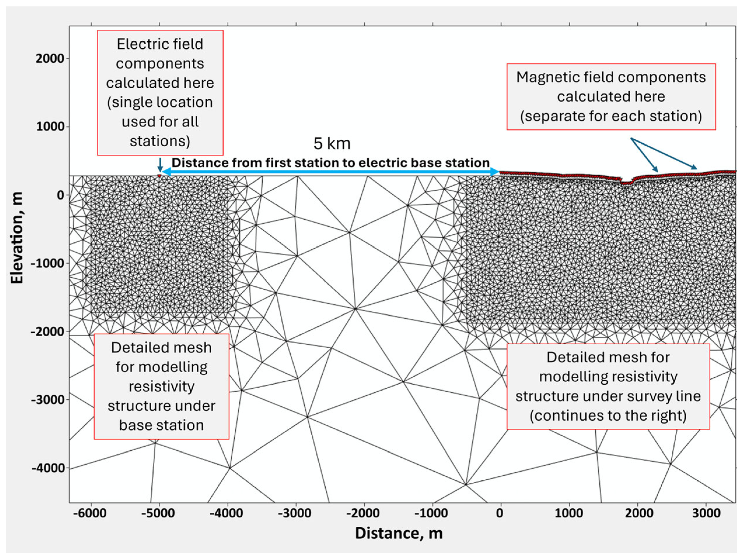
- Describe an automated mesh-generation routine that embeds separate, high-resolution sub-meshes beneath flight lines and the remote base station, capturing local electric-field scaling without inflating model size;
- -
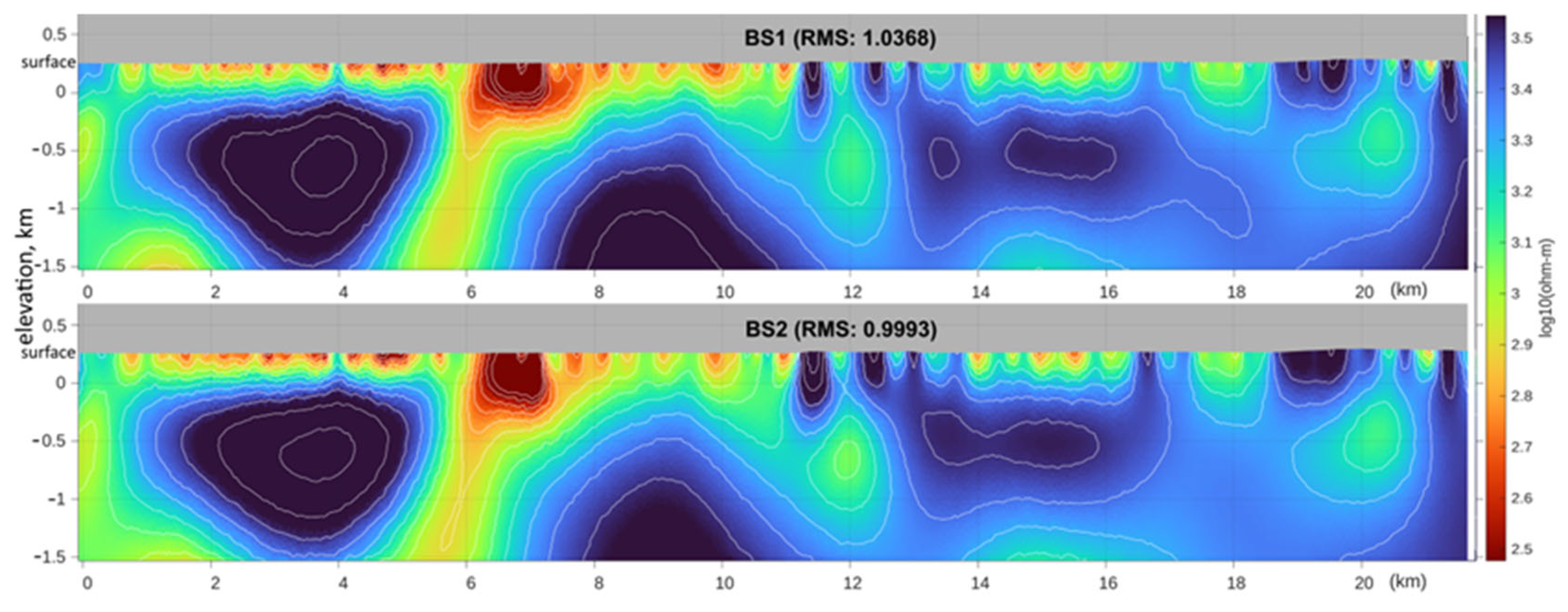
- Validate the workflow on a field test line in the Abitibi Greenstone Belt, showing that base station position alters the apparent-resistivity curve shape but not the inverted resistivity sections;
- -
- Demonstrate the importance of retaining the upper-decade (>4 kHz) MobileMT data for resolving deep structures and conductors with the support of recovering near-surface geology.
2. MobileMT Technique Overview
- -
- Directional sensitivity to horizontal, vertical, and sloping geoelectrical boundaries;
- -
- Rotational invariance, eliminating the need for tilt corrections, which are not efficient in rugged relief and near 3D sources of anomalies and improving signal-to-noise in comparison with tipper measurements in the air.
- -
- Elimination of galvanic distortion and the need for related static corrections;
- -
- Suppression of short-period surf and tidal EM noise in near-coastal surveys;
- -
- Reduced sensitivity to topographic effects compared with ground magnetotellurics (MT) in H-mode and with tipper data, because the MobileMT configuration is functionally equivalent to TE-mode, which is inherently less affected by topographic distortions than H-mode or tipper measurements [3].
3. Inversion Software, Data Preparation, and Inversion Workflow
- -
- Accurately model hybrid MT field configurations with E–H separation;
- -
- Resolve complex geoelectrical structures at multiple scales using adaptive meshing;
- -
- Handle large and data-intensive surveys typical for airborne EM through parallel inversion;
- -
- Support anisotropy and advanced inversion constraints needed for modern exploration.
4. Test Field Examples with MARE2DEM Inversions and Analysis
- (1)
- The impact of local geoelectrical conditions at the base station location on apparent conductivity datasets and their corresponding inversion results (Field Example 1);
- (2)
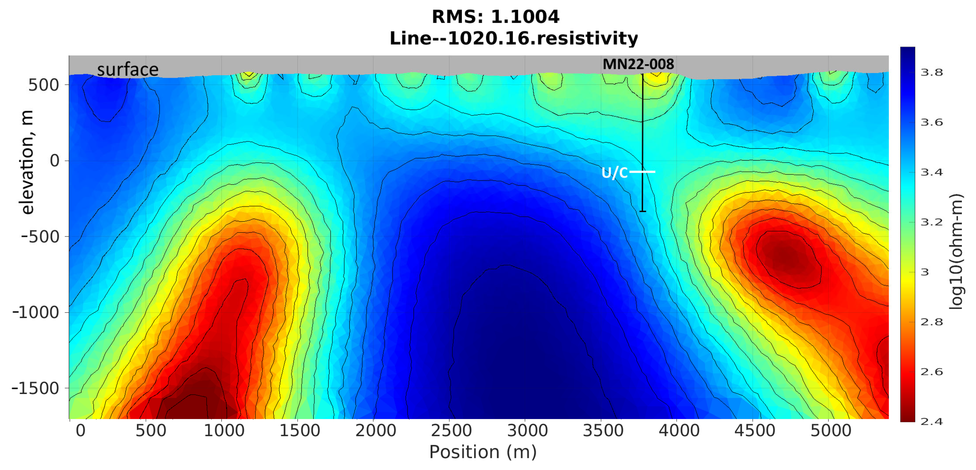
- The effect of including high-frequency data on the recovery and resolution of deep structures, particularly in the presence of a comparatively conductive near-surface layer within an overall resistive environment (Field example 2).
4.1. Field Example 1: Effect of Base Station Location on Apparent Conductivities Curves and the Data Inversions
- -
- Reference station normalization: Apparent conductivities are first computed by normalizing the acquired airborne magnetic spectra by the electric-field spectra from a single base station. MARE2DEM then inverts these apparent conductivity data, removing the frequency-dependent amplitude bias introduced by the shallow ground beneath the base station.
- -
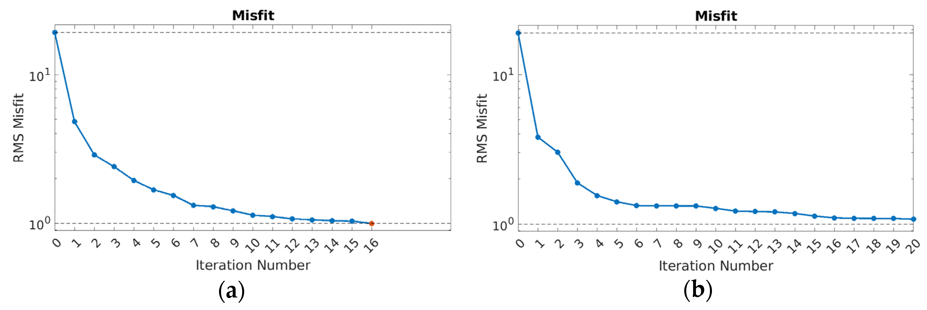
- A full update of the Jacobian elements is provided at each iteration of the finite-element inversion. The algorithm honors the correct frequency behavior of the EM field while it adjusts the resistivity model to fit the data.
4.2. Field Example 2: Impact of High-Frequency Data on Resistivity Imaging
- -
- Dataset 1 (low frequencies only, LF): 12 frequencies ranging from 26 Hz to 338 Hz;
- -
- Dataset 2 (low + high frequencies, LF+HF): The same 12 frequencies plus 3 higher frequencies at 5382, 6786, and 8550 Hz.
- -
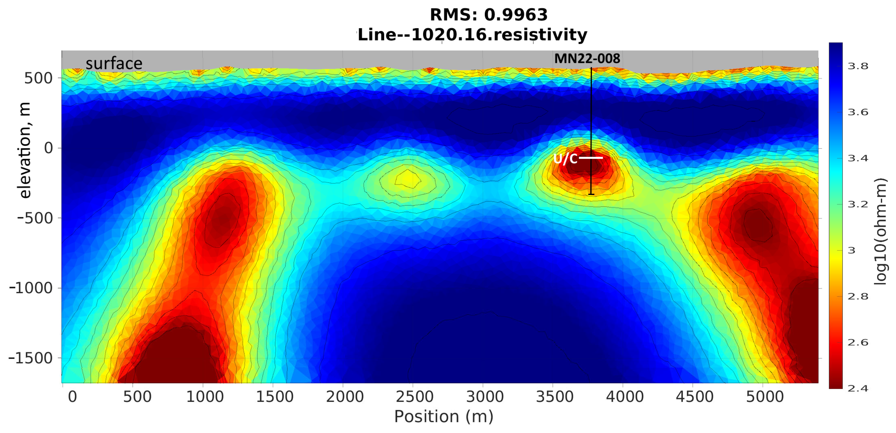
- Clearly resolves shallow conductive features; the comparatively conductive layer on the surface most likely corresponds to the glacial sediment cover documented in the region [16];
- -
- Defines the thickness of the Athabasca Basin Group sandstones and the unconformity contact more accurately;
- -
- Recovers the deeper conductor near the unconformity, confirmed by drillhole MN22-008, with well-defined geometry;
- -
- Demonstrates both improved shallow resolution and enhanced deep structure delineation.
- -
- Poor resolution of near-surface layers, while barely recovering the glacial sediments;
- -
- More diffuse inversion results, showing a smearing of deeper conductors and displaced or poorly resolved anomalies;
- -
- Broader, less sharply defined conductive and resistive zones with greater depth uncertainty;
- -
- Slow convergence due to greater non-uniqueness caused by unresolved shallow structures.
- -
- μ0 = magnetic permeability of free space (4π × 10−7 H/m);
- -
- σ = electrical conductivity (S/m);
- -
- ω = angular frequency (2πf).
- -
- Shallow σ(z) is underconstrained without HF data, and the error propagates into depth;
- -
- Shallow σ(z) is tightly constrained with HF data, and deep recovery becomes more robust.
- HF + LF inversion (Figure 11a): A wide distribution with a strong right-hand tail reflects many large-magnitude sensitivity entries; near-surface constraints are strong, and a useful tail persists through increasing depth.
- LF-only inversion (Figure 11b): The right, most sensitive tail is truncated; high-magnitude entries disappear and the overall distribution narrows, indicating diminished near-surface control and a less stable deep solution.
- -
- HF + LF run (Figure 10a): Roughness increases steadily after iteration 3 and stabilizes ≈38, showing that genuine geological gradients are preserved.
- -
- LF-only run (Figure 10b): Roughness plateaus early at ≈11; the algorithm must over-smooth the model to offset the rank loss caused by missing HF rows.
- High-frequency data are indispensable, not optional, especially in highly resistive environments where skin depths of high frequencies are significant. They secure strong, comparatively shallow sensitivities, improve the condition number of JT Wd J, and raise the resolution matrix toward the identity at all depths.
- Broadband inversion relaxes the need for heavy smoothing, allowing legitimate resistivity gradients to persist.
5. Conclusions
Author Contributions
Funding
Data Availability Statement
Acknowledgments
Conflicts of Interest
Abbreviations
| EM | Electromagnetic |
| MT | Magnetotelluric |
| 2D | Two-dimensional |
| 3D | Three-dimensional |
| LF | Low-frequency |
| HF | High-frequency |
| BS | Base station |
| MARE2DEM | Modeling with Adaptively Refined Elements for 2D EM |
| ScaLAPACK | Scalable Linear Algebra PACKage |
Appendix A
- -
- A mobile airborne magnetic sensor, towed beneath a helicopter or drone, with three orthogonal dB/dt inductive coils for recording magnetic field variations:
- -
- A stationary ground-based electric field receiver, consisting of two perpendicular pairs of grounded wire lines, measuring horizontal E-field variations, used for remote reference processing:
- -
- S(f) is a 3 × 2 matrix of complex, frequency-dependent transfer coefficients that relate the two orthogonal electric field components measured at the base station to the three orthogonal magnetic field components measured in the airborne module. The transfer tensor S(f) inherently contains the responses for all source polarizations present in the natural EM field;
- -
- H(f) and E0(f) are the Fourier-transformed components of airborne and base station data, respectively.
- (1)
- Cross-product vector:
- (2)
- Singular value decomposition of the transfer tensor defined under (A3):
- (3)
- The norm gain, which is defined as the ratio of the total amplitude of the three-component airborne magnetic field to the total amplitude of the two-component base station electric field:
References
- Alumbaugh, D.; Huang, H.; Livermore, J.; Velasco, M.S. Resistivity imaging in a fold and thrust belt using ZTEM and sparse MT data. First Break 2016, 34, 65–72. [Google Scholar] [CrossRef]
- Prikhodko, A.; Bagrianski, A.; Wilson, R.; Belyakov, S.; Esimkhanova, N. Detecting and recovering critical mineral resource systems using broadband total-field airborne natural source audio frequency magnetotellurics measurements. Geophysics 2024, 89, WB13–WB23. [Google Scholar] [CrossRef]
- Saini, S.; Tyagi, D.K.; Kumar, S.; Sehrawat, R. Modelling of the terrain effect in magnetotelluric data from the Garhwal Himalaya region. Nonlinear Process. Geophys. 2024, 31, 175–184. [Google Scholar] [CrossRef]
- Cowan, D.C.; Understanding MobileMT Data. UBC-GIF 2023. Available online: https://giftoolscookbook.readthedocs.io/en/latest/content/comprehensive_workflow/mmt/1_basic_anomalies.html (accessed on 15 July 2025).
- Sattel, D.; Witherly, K.; Kaminski, V. A brief analysis of MobileMT data. In Proceedings of the 89th Society of Exploration Geophysicists International Exposition and Annual Meeting, San Antonio, TX, USA, 15–20 September 2019. [Google Scholar] [CrossRef]
- Jorgensen, M.; Zhdanov, M.S.; Gribenko, A.; Cox, L.; Sabra, H.E.; Prikhodko, A. 3D Inversion and Interpretation of Airborne Multiphysics Data for Targeting Porphyry System, Flammefjeld, Greenland. Minerals 2024, 14, 1130. [Google Scholar] [CrossRef]
- Prikhodko, A.; Bagrianski, A.; Kuzmin, P. Airborne Natural Total Field Broadband Electromagnetics—Configurations, Capabilities, and Advantages. Minerals 2024, 14, 704. [Google Scholar] [CrossRef]
- White Cliff Minerals Limited. Geophysical Anomalies Reveal New Copper Targets at Rae Project. White Cliff Minerals Limited (ASX:WCN). Available online: https://www.listcorp.com/asx/wcn/white-cliff-minerals-limited/news/geophysical-anomalies-reveal-new-copper-targets-at-rae-3118754.html (accessed on 15 July 2025).
- Prikhodko, A.; Sirohey, A.; Bagrianski, A. Exploration for Deep Gold-Bearing Structures with Natural Field Airborne Electromagnetics. In Proceedings of the 17th SAGA Biennial Conference & Exhibition, Sun City, South Africa, 28 November–1 December 2022. Extended Abstracts. [Google Scholar]
- Key, K. MARE2DEM: A 2-D inversion code for controlled-source electromagnetic and magnetotelluric data. Geophys. J. Int. 2016, 207, 571–588. [Google Scholar] [CrossRef]
- MARE2DEM. About MARE2DEM. 2022. Available online: https://mare2dem.bitbucket.io/master/about.html (accessed on 15 July 2025).
- Key, K.; Weiss, C. Adaptive finite-element modeling using unstructured grids: The 2D magnetotelluric example. Geophysics 2006, 71, G291–G299. [Google Scholar] [CrossRef]
- Cowan, D.C.; Heagy, L.J.; Oldenburg, D.W. Airborne Natural Source Electromagnetics for an Arbitrary Base Station. Geophys. J. Int. 2025, 241, 1962–1975. [Google Scholar] [CrossRef]
- Basin Uranium Corp. Mann Lake Project. Available online: https://basinuranium.ca/mannlake-project/ (accessed on 17 July 2025).
- Jefferson, C.W.; Thomas, D.J.; Gandhi, S.S.; Ramaekers, P.; Delaney, G.; Brisbin, D.; Cutts, C.; Quirt, D.; Portella, P.; Olson, R.A. Unconformity-Associated Uranium Deposits of the Athabasca Basin, Saskatchewan and Alberta. In Mineral Deposits of Canada: A Synthesis of Major Deposit-Types, District Metallogeny, the Evolution of Geological Provinces, and Exploration Methods; Goodfellow, W.D., Ed.; Special Publication No. 5; Geological Association of Canada, Mineral Deposits Division: St. John’s, NL, Canada, 2007; pp. 273–305. [Google Scholar]
- Campbell, J.E. Quaternary Geology of the Eastern Athabasca Basin, Saskatchewan. In EXTECH IV: Geology and Uranium Exploration Technology of the Proterozoic Athabasca Basin, Saskatchewan and Alberta; Jefferson, C.W., Delaney, G., Eds.; Geological Survey of Canada, Bulletin 588: Ottawa, ON, Canada, 2007; pp. 211–228. [Google Scholar] [CrossRef]
- Basin Uranium Corp. Basin Uranium Completes Geophysical Surveys at Mann Lake. 2022. Available online: https://basinuranium.ca/basin-uranium-completes-geophysical-surveys-at-mann-lake/ (accessed on 17 July 2025).
- Basin Uranium Corp. Basin Uranium Continues to Intersect Anomalous Uranium Mineralization at Mann Lake. 2023. Available online: https://basinuranium.ca/basin-uranium-continues-to-intersect-anomalous-uranium-mineralization-at-mann-lake/ (accessed on 17 July 2025).
- Zhdanov, M.S. Inverse Theory and Applications in Geophysics, 2nd ed.; Elsevier: Amsterdam, The Netherlands, 2015. [Google Scholar]
- Berdichevskiĭ, M.N.; Zhdanov, M.S. Advanced Theory of Deep Geomagnetic Sounding; Elsevier Science Ltd.: Amsterdam, The Netherlands, 1984; Volume 19. [Google Scholar]






Disclaimer/Publisher’s Note: The statements, opinions and data contained in all publications are solely those of the individual author(s) and contributor(s) and not of MDPI and/or the editor(s). MDPI and/or the editor(s) disclaim responsibility for any injury to people or property resulting from any ideas, methods, instructions or products referred to in the content. |
© 2025 by the authors. Licensee MDPI, Basel, Switzerland. This article is an open access article distributed under the terms and conditions of the Creative Commons Attribution (CC BY) license (https://creativecommons.org/licenses/by/4.0/).
Share and Cite
Prikhodko, A.; Sirohey, A.; Philipovich, A. Advancing Deep Ore Exploration with MobileMT: Rapid 2.5D Inversion of Broadband Airborne EM Data. Minerals 2025, 15, 874. https://doi.org/10.3390/min15080874
Prikhodko A, Sirohey A, Philipovich A. Advancing Deep Ore Exploration with MobileMT: Rapid 2.5D Inversion of Broadband Airborne EM Data. Minerals. 2025; 15(8):874. https://doi.org/10.3390/min15080874
Chicago/Turabian StylePrikhodko, Alexander, Aamna Sirohey, and Aleksei Philipovich. 2025. "Advancing Deep Ore Exploration with MobileMT: Rapid 2.5D Inversion of Broadband Airborne EM Data" Minerals 15, no. 8: 874. https://doi.org/10.3390/min15080874
APA StylePrikhodko, A., Sirohey, A., & Philipovich, A. (2025). Advancing Deep Ore Exploration with MobileMT: Rapid 2.5D Inversion of Broadband Airborne EM Data. Minerals, 15(8), 874. https://doi.org/10.3390/min15080874


