
Volcanic Stratigraphy, Petrology, Geochemistry and Precise U-Pb Zircon Geochronology of the Late Ediacaran Ouarzazate Group at the Oued Dar’a Caldera: Intracontinental Felsic Super-Eruptions in Association with Continental Flood Basalt Magmatism on the West African Craton (Saghro Massif, Anti-Atlas)


 , , , , ,
  ,
, 
Abstract
1. Introduction
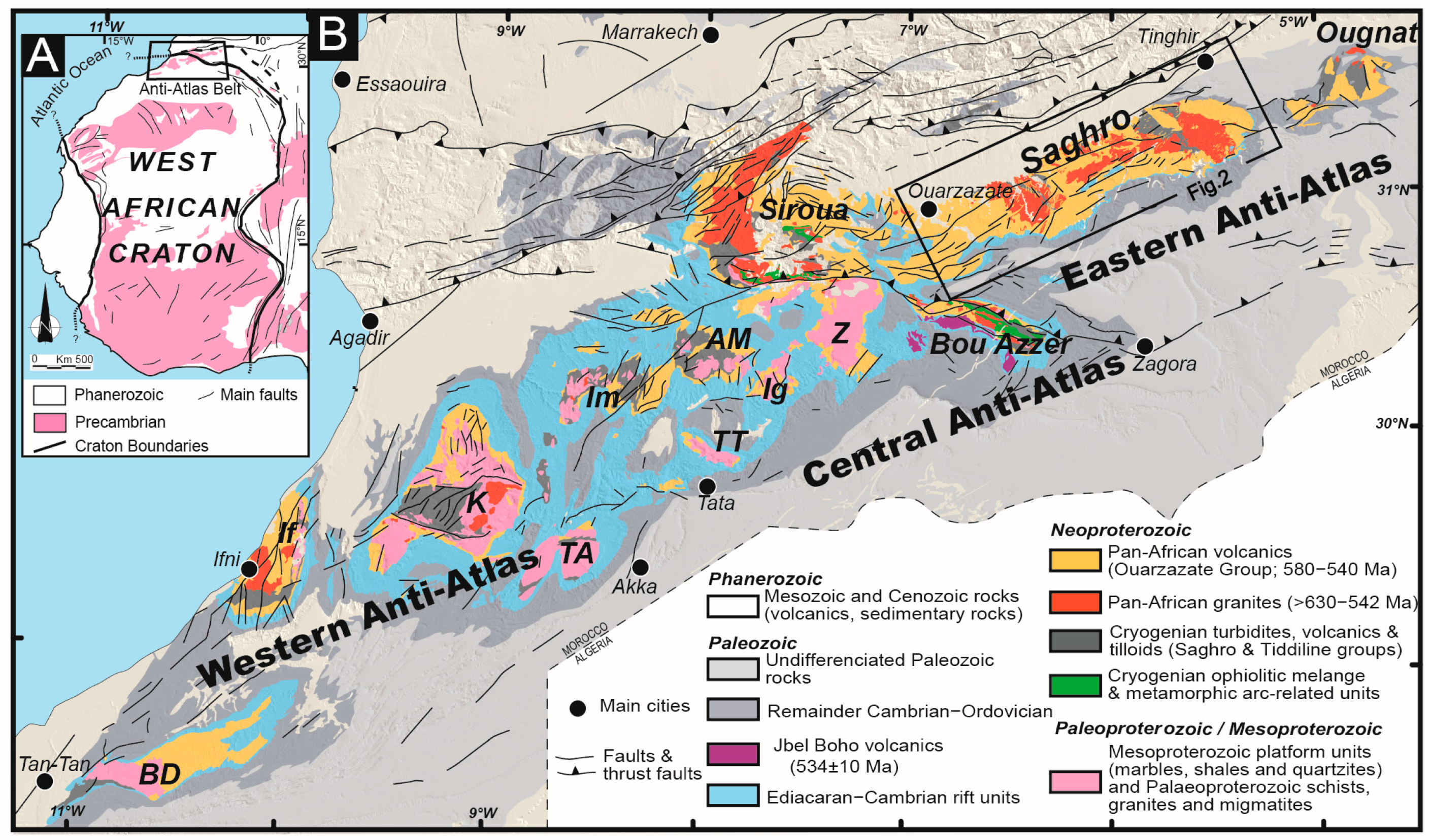
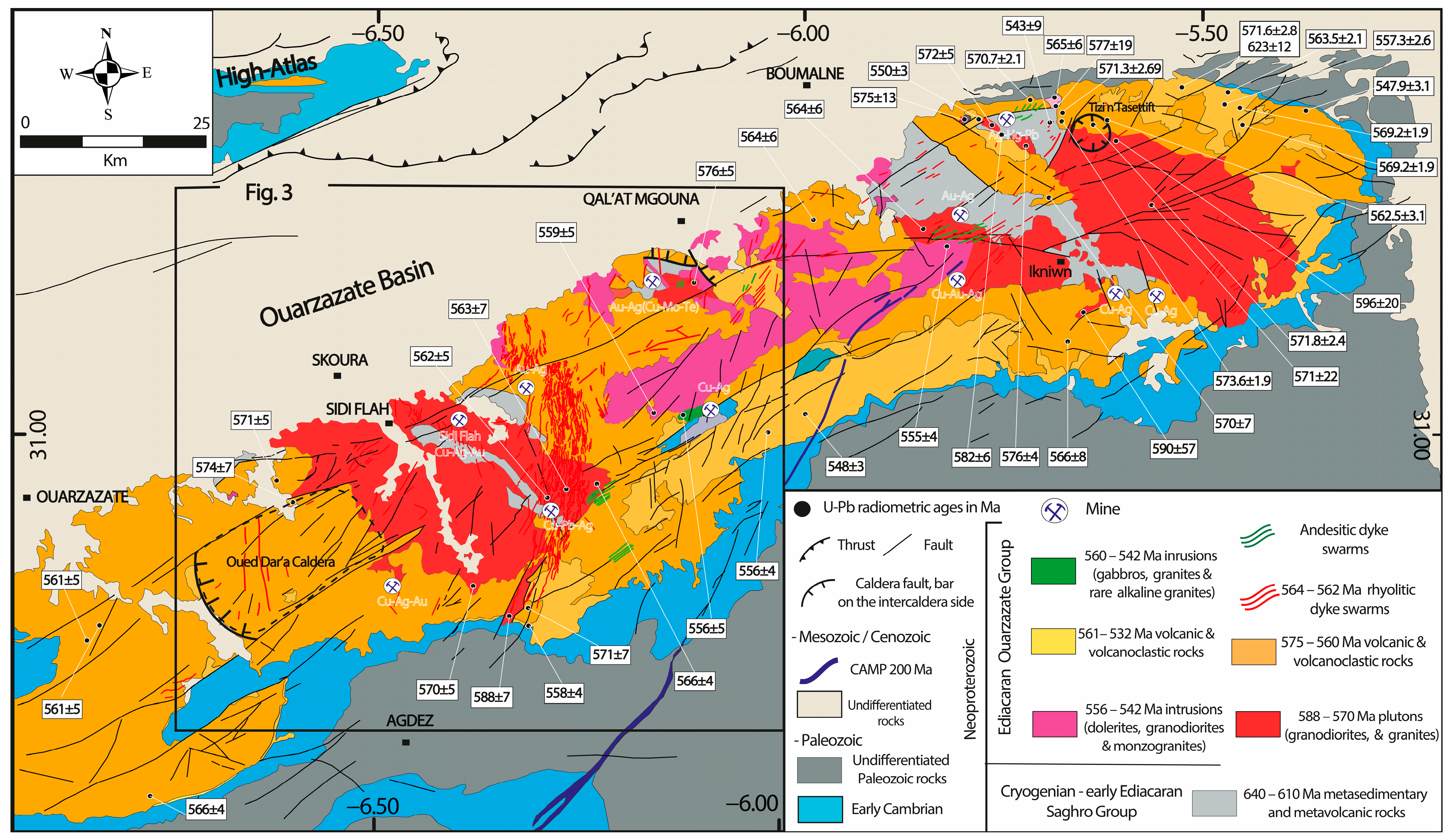
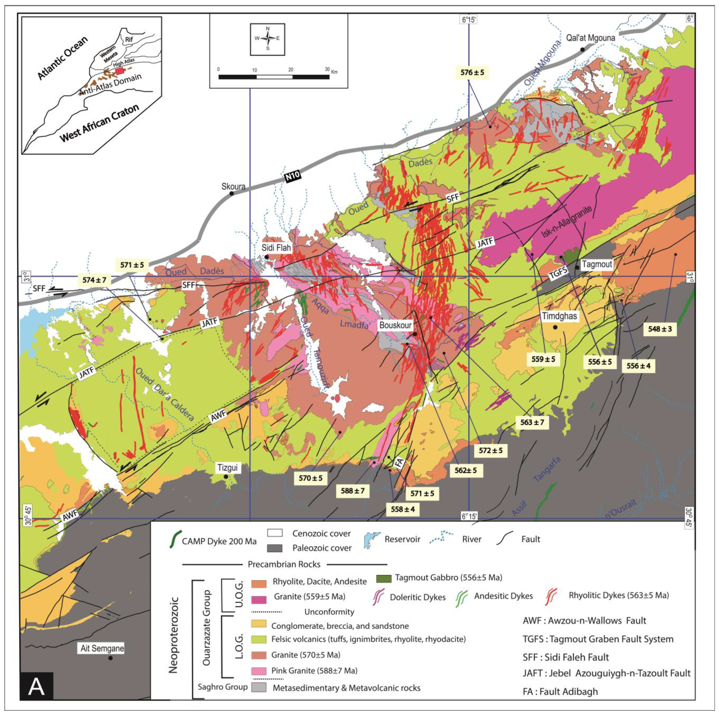
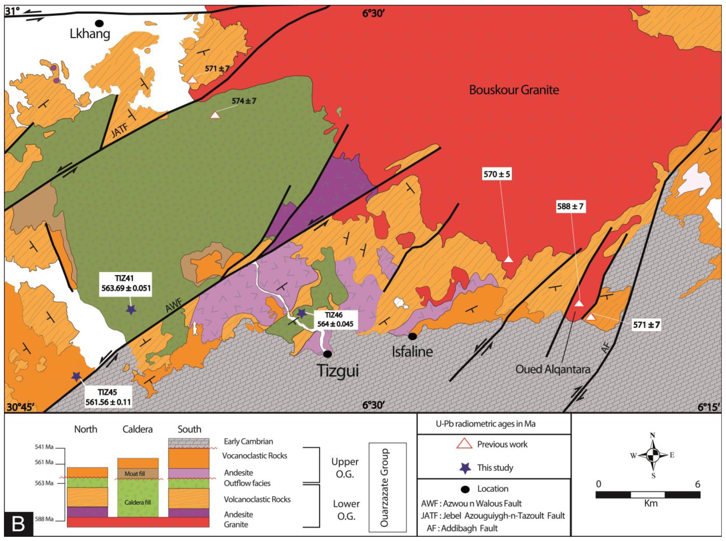
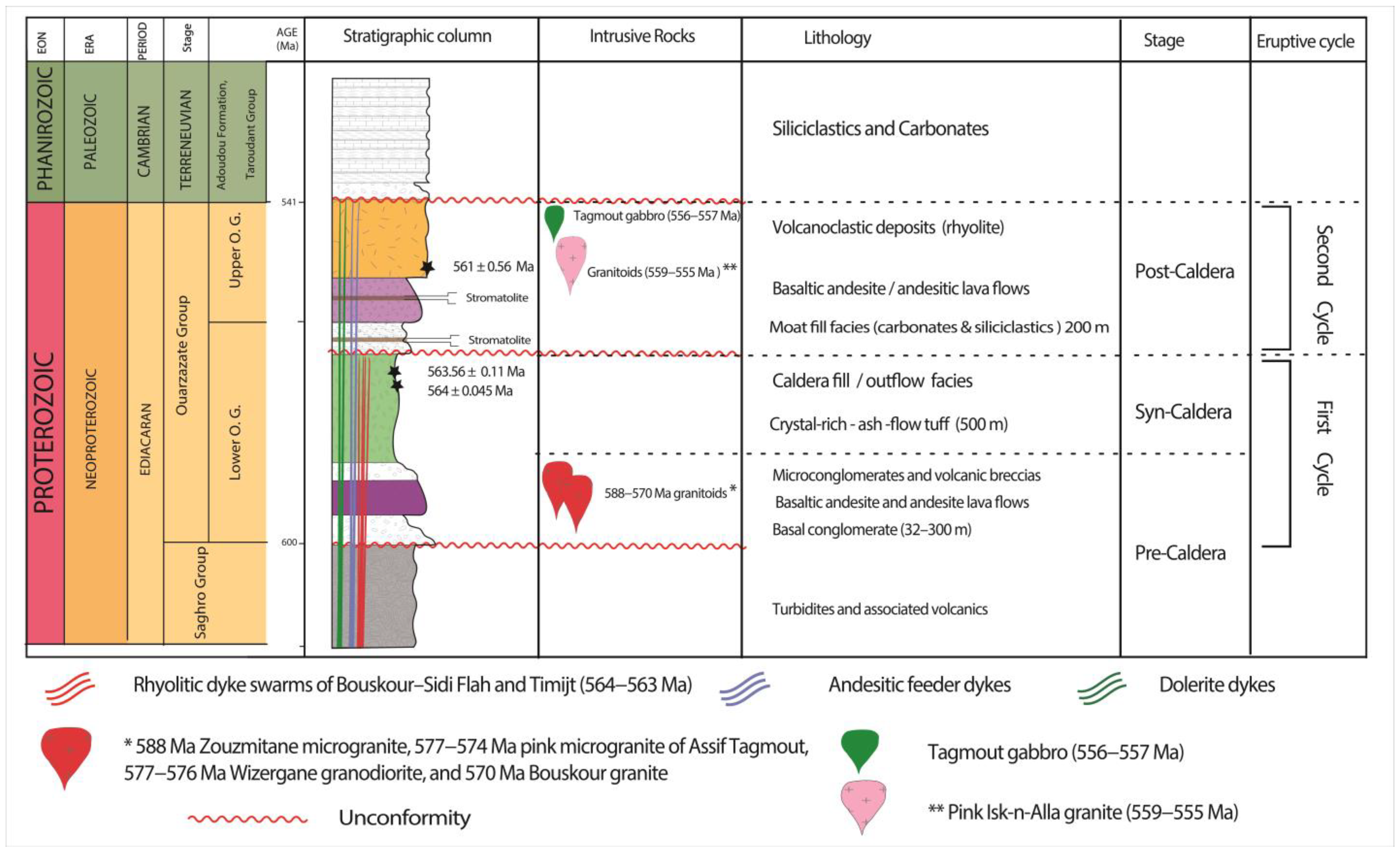
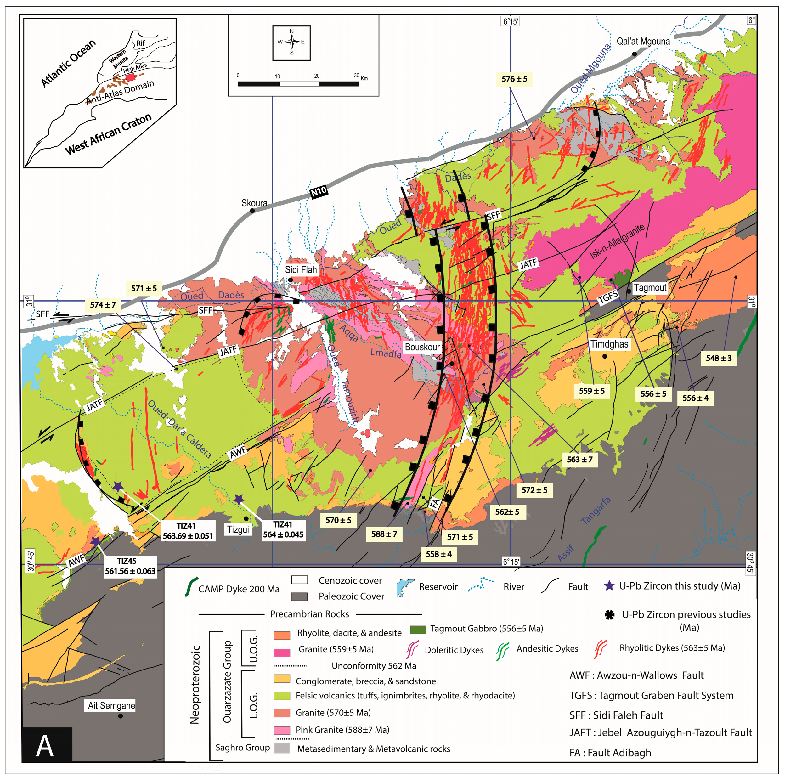
2. Geological Background
3. Sampling and Methods
3.1. U–Pb Geochronology: CA-ID-TIMS U-Pb Zircon Dating
3.2. Whole-Rock Geochemistry
4. Results
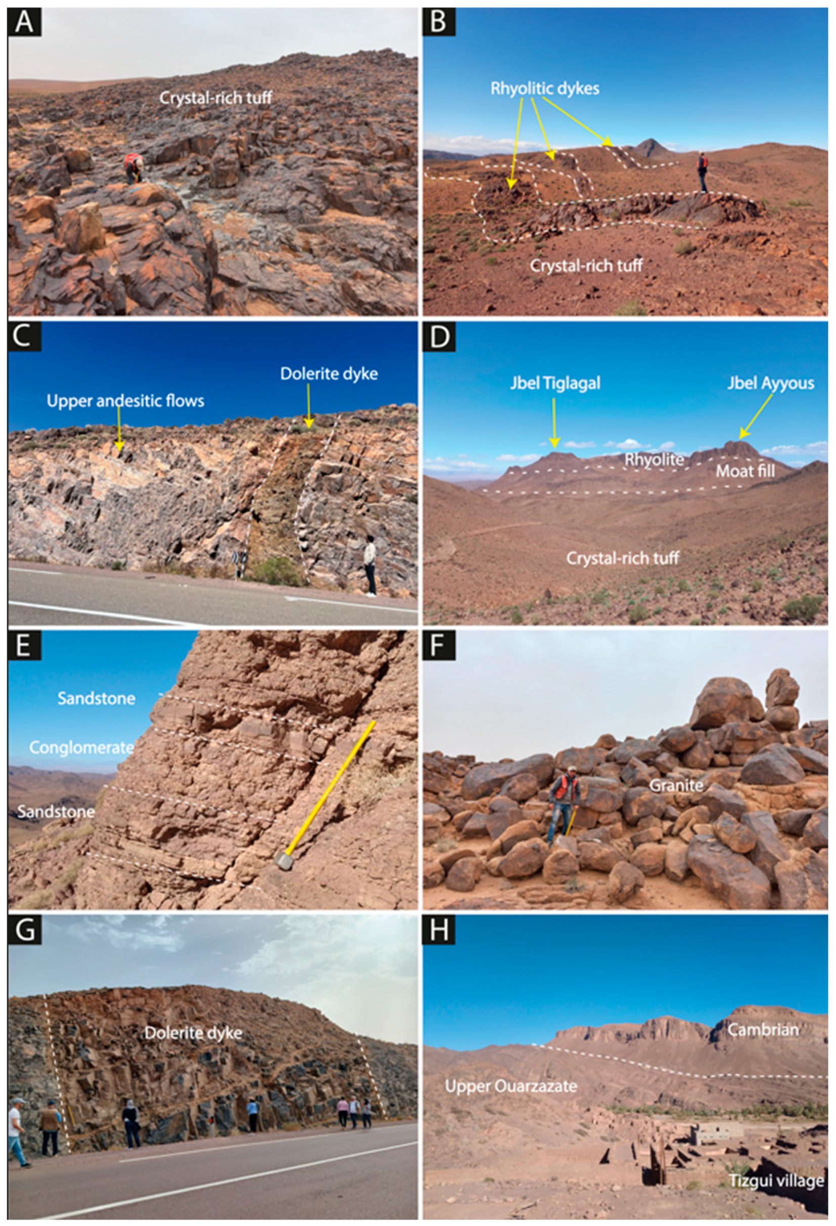
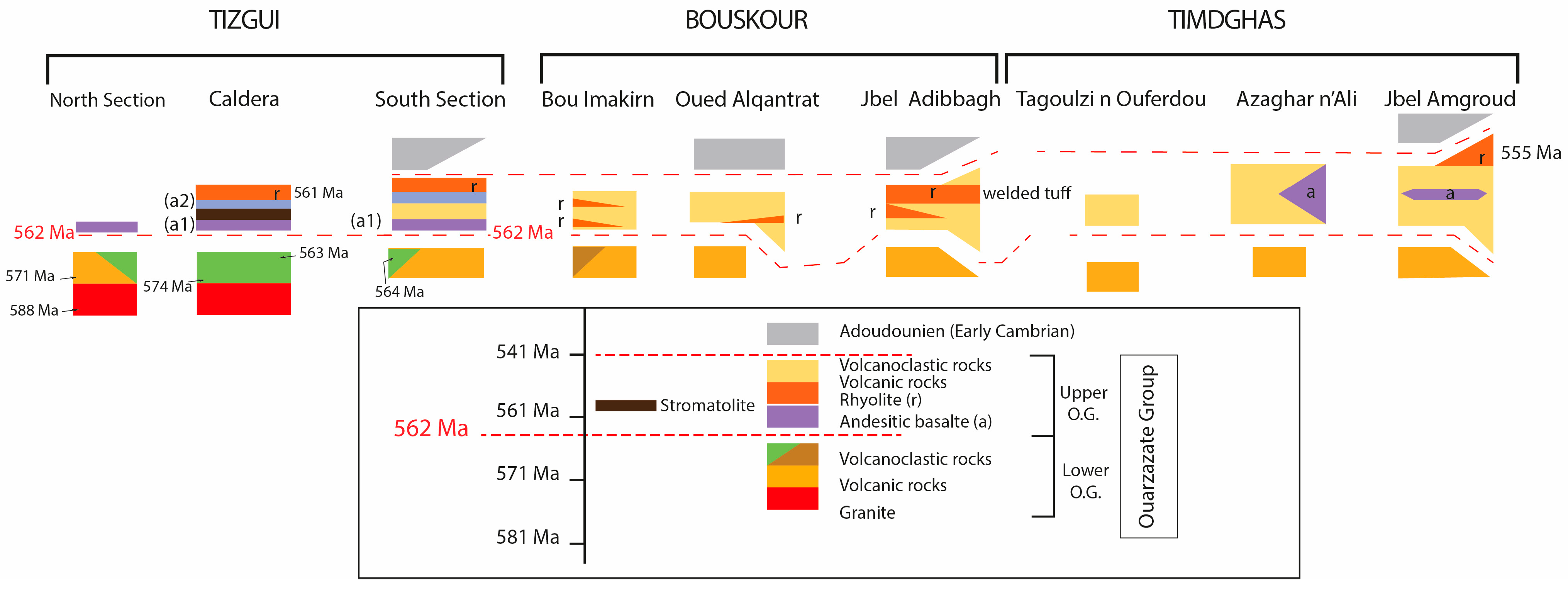
4.1. Volcanic Stratigraphy and Petrography of the ODC
4.1.1. Pre-Caldera Stage
- Basal conglomerates
- Lower basaltic andesite and andesitic lava flows
4.1.2. Syn-Caldera Stage
4.1.3. Post-Caldera Stage
- Upper basaltic andesite and andesitic lava flows
- The caldera moat-filling sequences
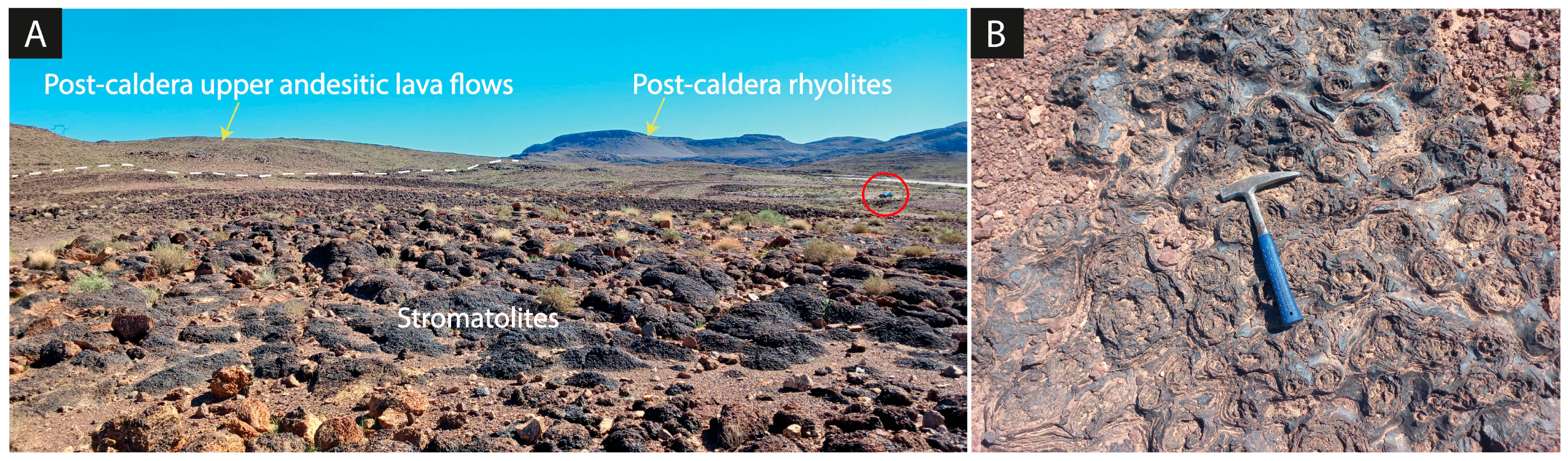
- Post-caldera rhyolites
4.1.4. Intrusive Rocks
- Granitoid plutons
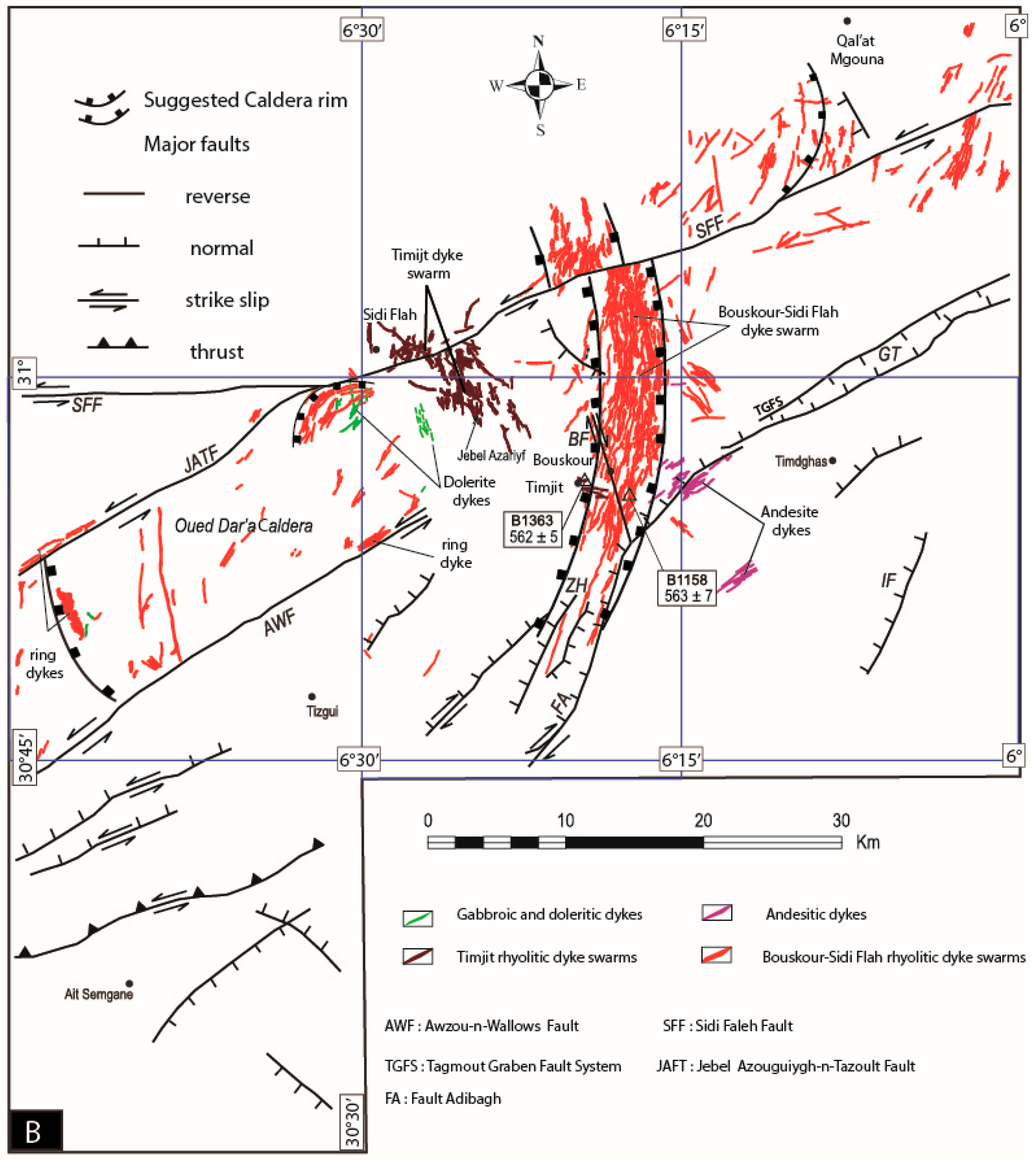
- Dyke Swarms
- Rhyolitic dykes
- Andesite dykes
- Dolerite dykes
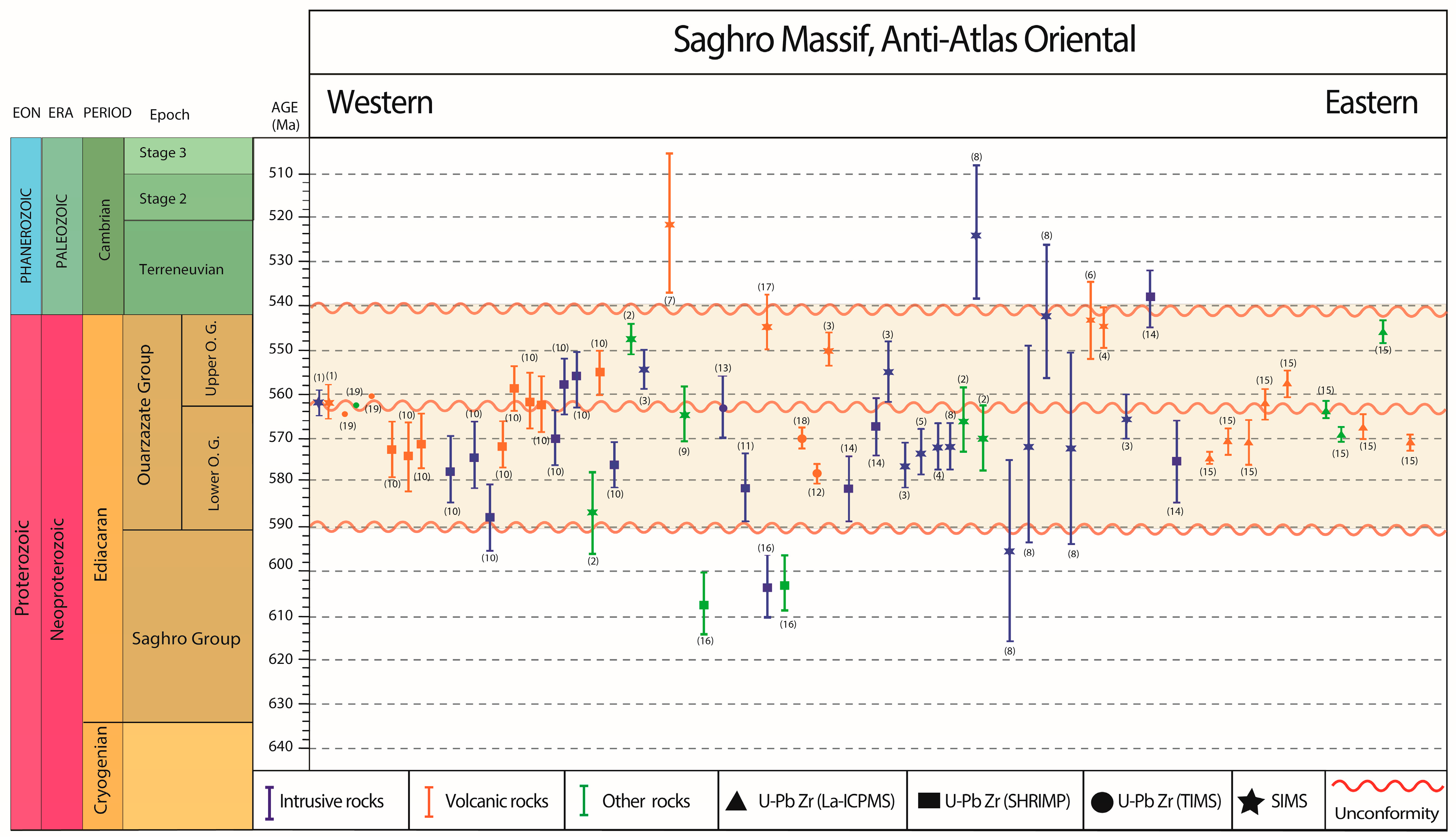
4.2. Zircon U–Pb Geochronology
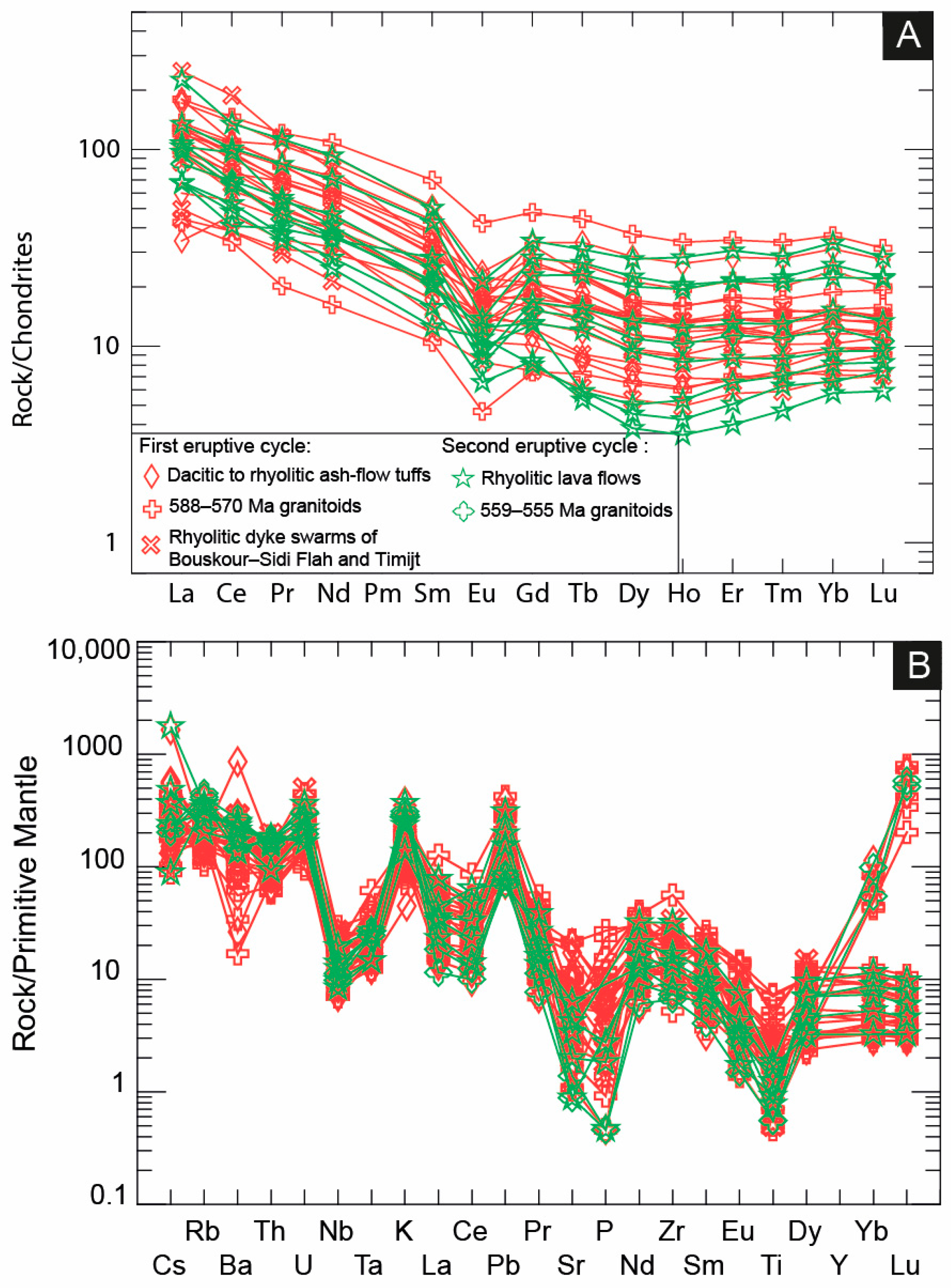
4.3. Whole Rock Geochemistry
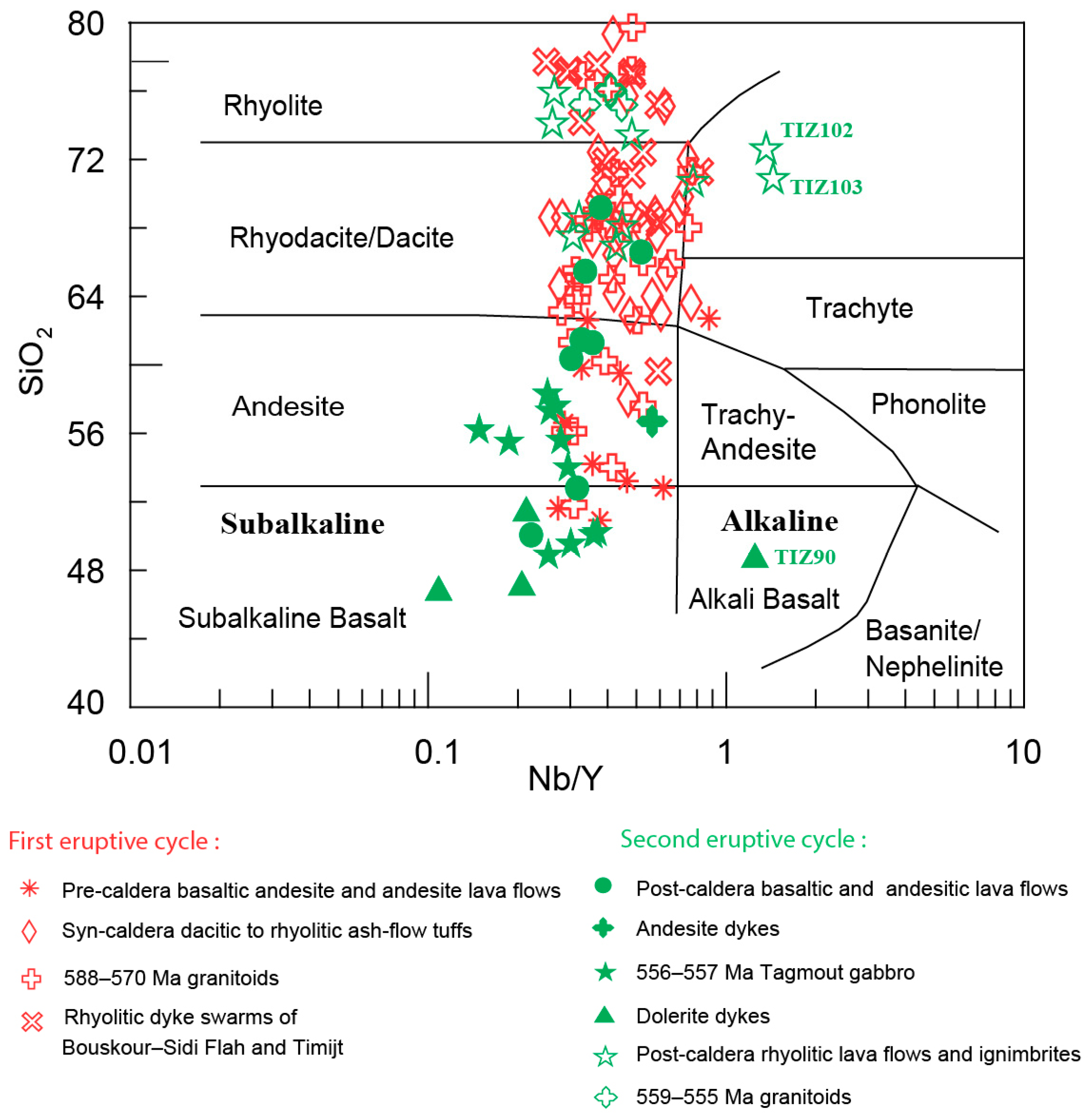
4.3.1. Classification of Magmatic Units of the Ediacaran Volcanic Succession of the ODC
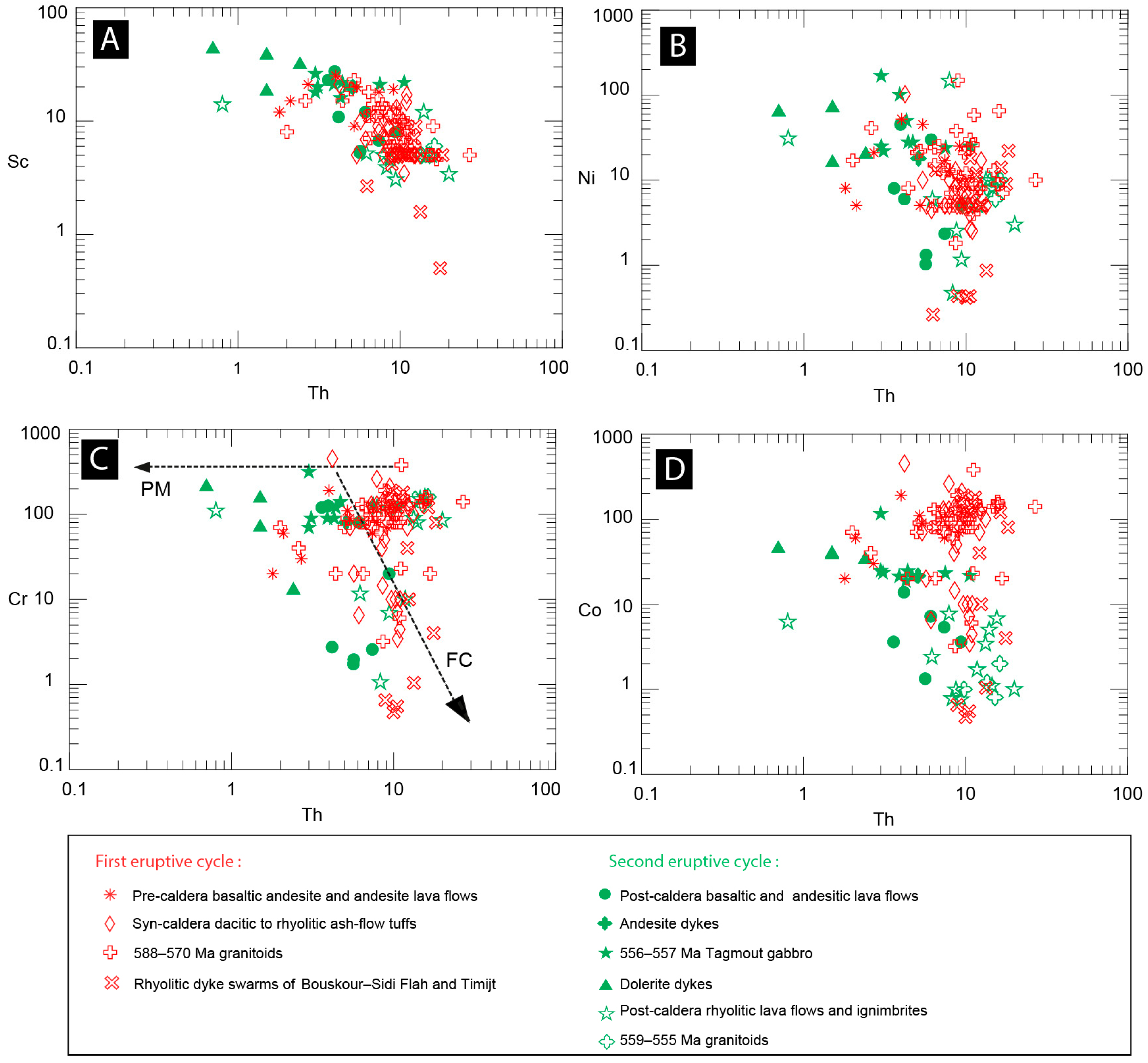
4.3.2. Geochemistry of the Igneous Rocks of the 1st Eruptive Cycle
- Mafic and intermediate rocks
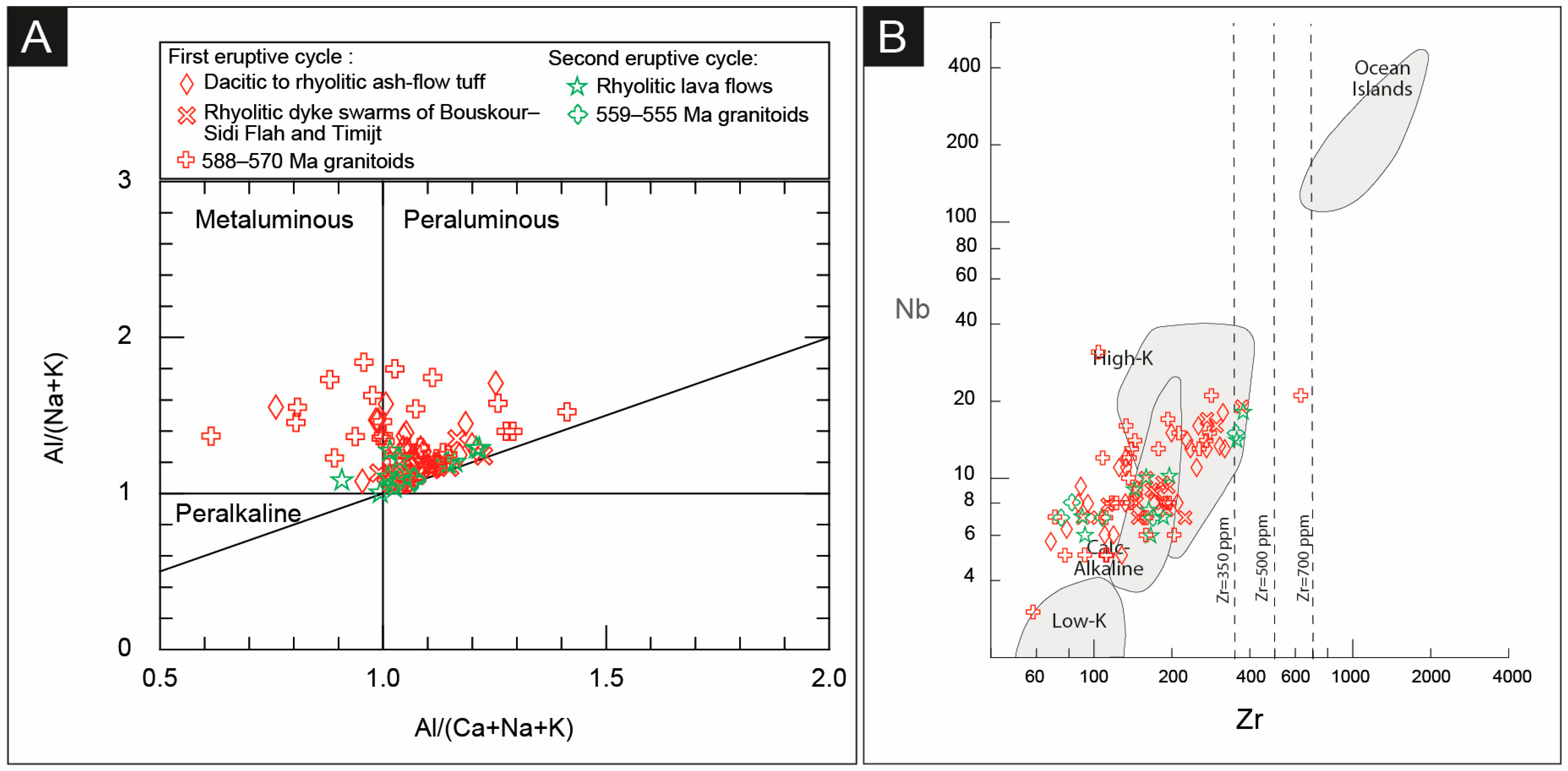
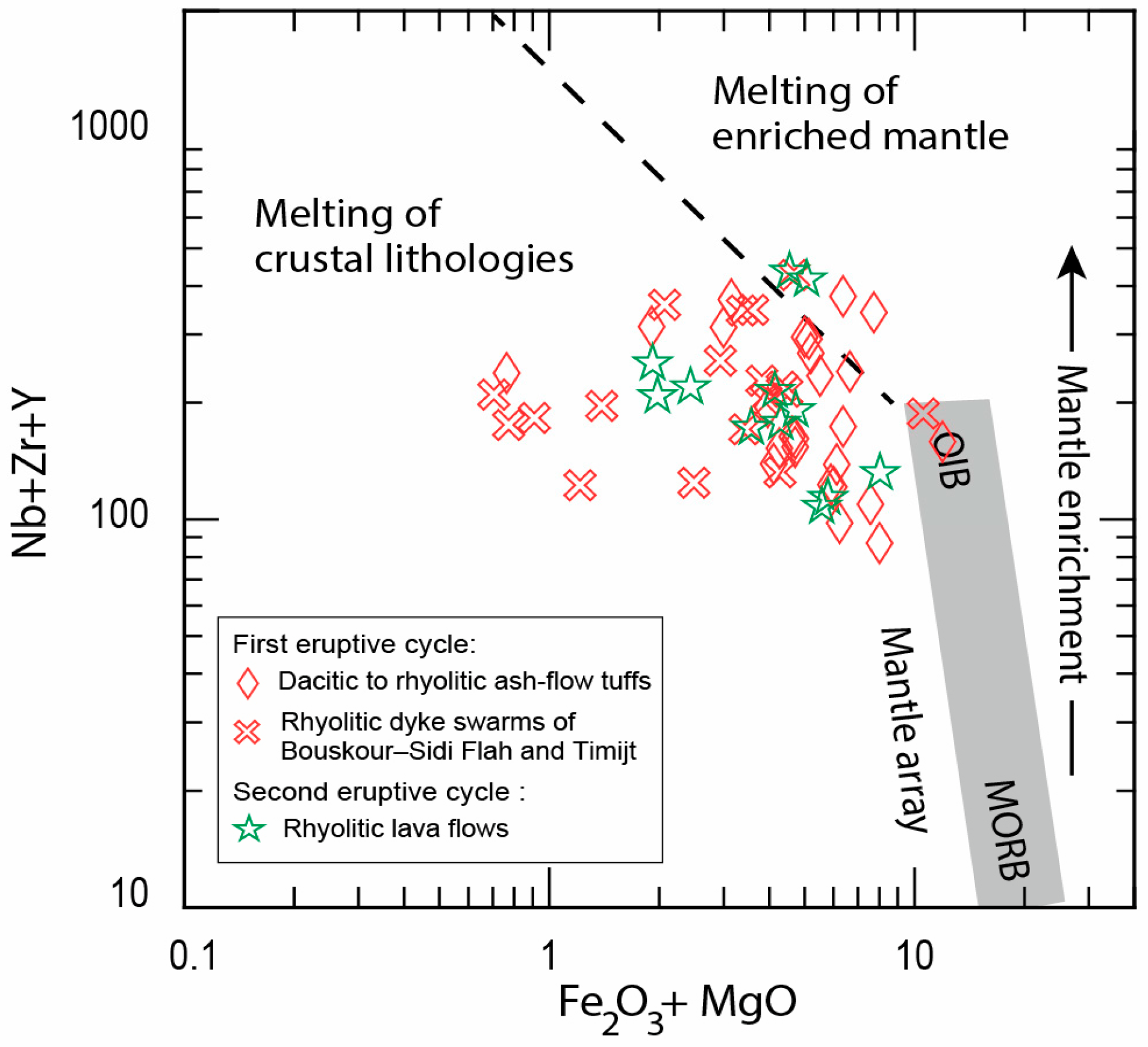
- Felsic rocks
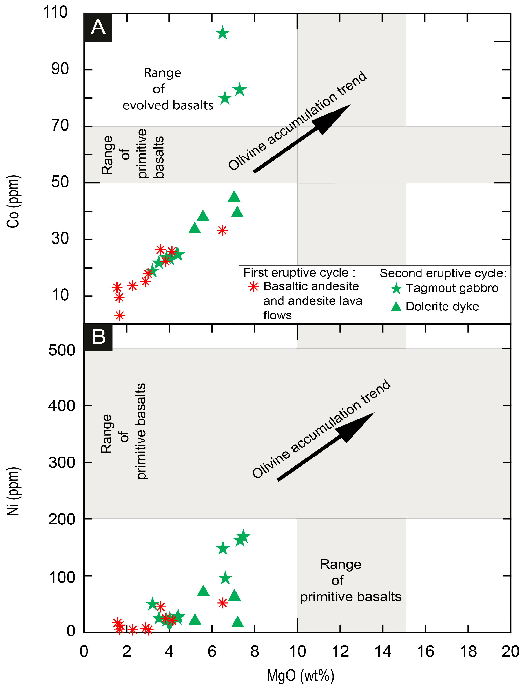
4.3.3. Geochemistry of the Igneous Rocks of the 2nd Eruptive Cycle
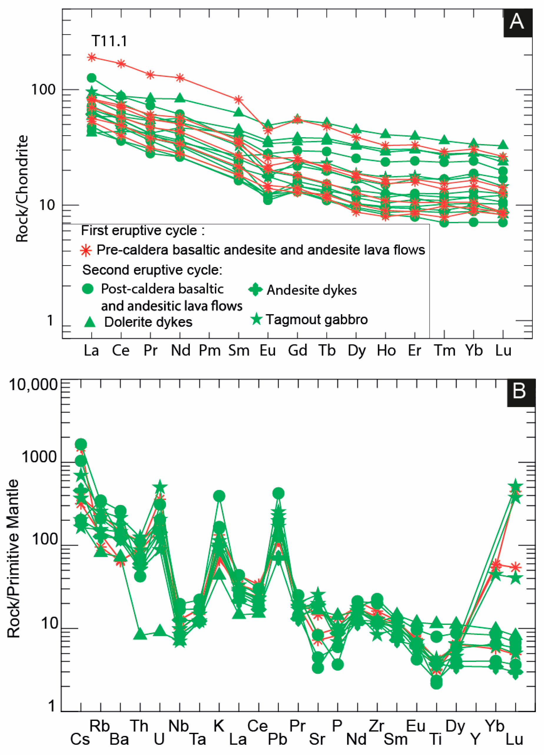
- Mafic and intermediate rocks
- Felsic Rocks
5. Discussion
5.1. Age of the ODC Igneous Succession
5.2. Architecture of the ODC: Unique Late Ediacaran Intra-Continental Silicic Super-Eruptions Within a Complex Caldera
5.3. Depositional Environment and Facies Model for the Volcanic Succession of the ODC
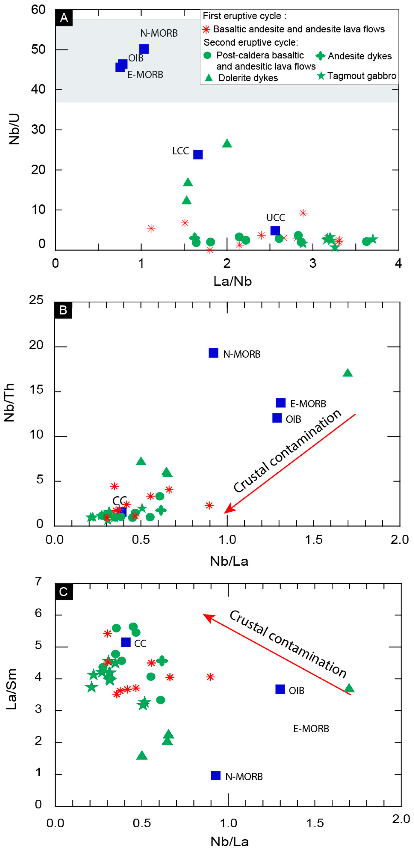
5.4. Petrogenesis and Tectonic Setting
5.4.1. Petrogenesis
5.4.2. Tectonic Setting
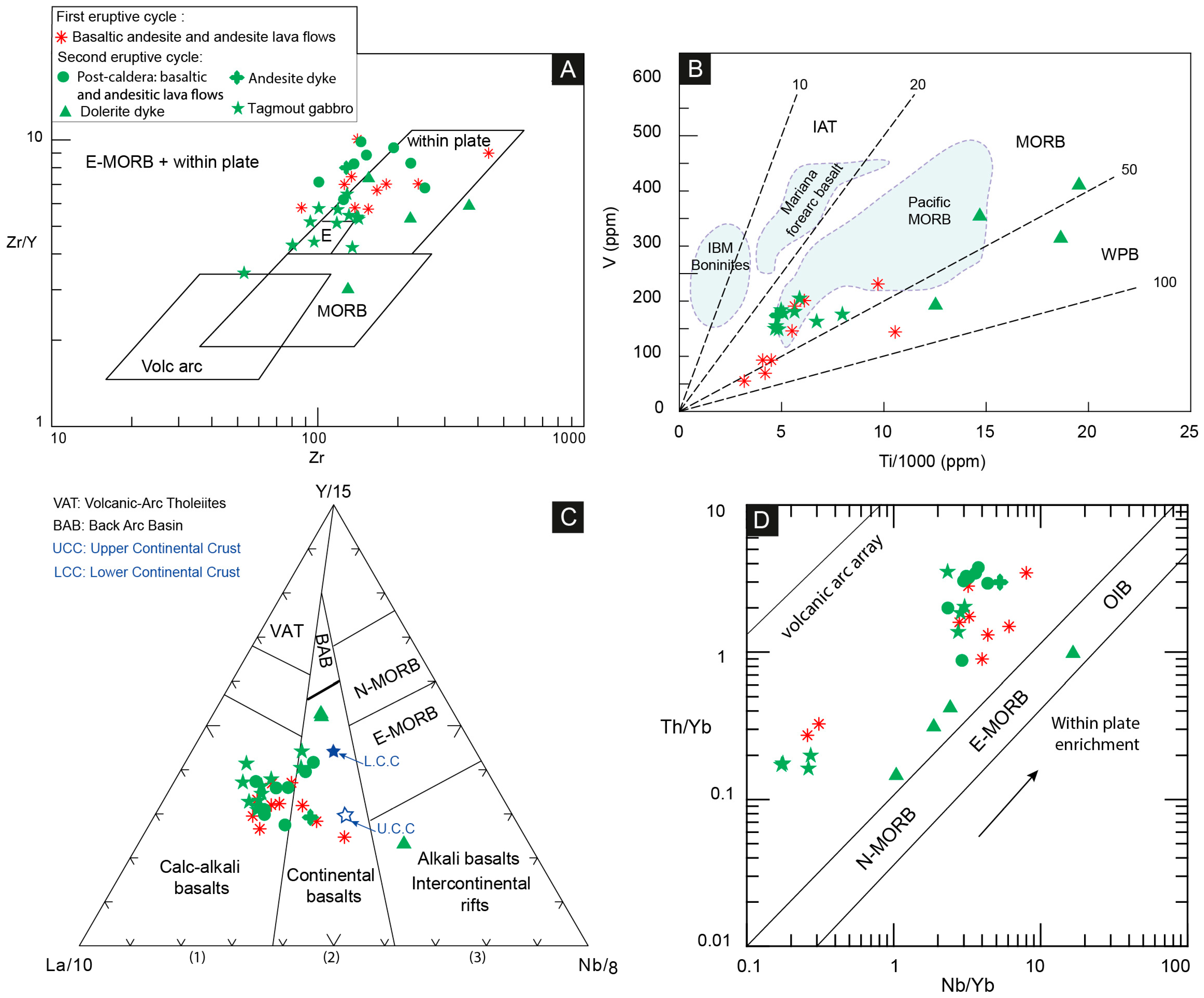
5.5. Geodynamic Setting of the ODC Volcanic Succession: A Pre-Iapetus Association of a Silicic Large Igneous Province (SLIP) with a Continental Flood Basalt Large Igneous Province (LIP)
6. Concluding Remarks
- According to their volcanological, stratigraphical, and geochemical characteristics, two consecutive eruptive cycles can be distinguished in the ODC volcanic succession of the Ouarzazate Group exposed in the Saghro Massif (Anti-Atlas Belt). The two eruptive cycles are separated by an unconformity estimated at 562 Ma, and correspond to Lower and Upper Ouarzazate Group, respectively.
- The 1st eruptive cycle (588–571 to 563 Ma) corresponds to the Lower Ouarzazate Group, and records the pre-caldera stage (lower basaltic andesite-andesite lava flows and associated volcanoclastic rocks) and the syn-caldera stage (dacitic to rhyolitic ash-flow tuff) that comprises intracaldera facies (caldera-forming eruption deposits), extracaldera facies (outflow sheets), and the Bouskour Sidi Flah and Timijt rhyolitic dyke swarms, as well as the ring dykes of the ODC. Mafic magmas of the 1st eruptive cycle clearly show chemical characteristics of calc-alkaline basalts emplaced in the aftermath of the Pan-African Orogeny. Mafic magmas were derived from a lithospheric mantle and a mantle influenced by the asthenosphere-lithosphere interaction and are temporally associated with the gravitational collapse of the Pan-African Orogen. Felsic rocks were generated by partial melting of continental crust. The 1st eruptive cycle is characterized by the formation of a large caldera system. The ODC spans approximately 35 km from east to west and 50 km from north to south and has an intracaldera ignimbrite layer that is over 500 m thick in places. This corresponds to a minimum eruptive volume of approximately 875 km3. Including the volume of the outflow-facies ash-flow tuffs nearly doubles the total eruptive volume to approximately 1750 km3, an amount typical of large caldera-forming events. If this volume were to be emplaced in a single eruption, it would correspond to a Volcanic Explosivity Index (VEI) of 8. The ODC is a late Ediacaran very large eruption or super-eruption (supervolcano) comparable in size to the 640 ka Yellowstone Caldera. The facies model for the ODC succession deposited during the 1st eruptive cycle is that of continental stratovolcanoes.
- The 2nd eruptive cycle (561 Ma to 548–542 Ma) corresponds to the Upper Ouarzazate Group and records the post-caldera stage (upper basaltic andesite-andesite lava flows and associated volcanoclastic rocks) and the terminal rhyolitic lava flows and ignimbrites. The 2nd cycle is marked by bimodal volcanism, featuring tholeiitic basalts (Continental Flood Basalts, CFB) also sourced from a lithospheric mantle and a mantle influenced by the asthenosphere-lithosphere interaction and felsic intraplate magmatisms. The proposed facies model is a composite of two conventional facies models for continental basaltic successions (continental flood basalt, CFB), and a continental silicic volcano type.
- The Ouarzazate Group of the Saghro Massif appears to be an association of two large igneous provinces (a compound LIP versus a simple LIP like the Central Atlantic Magmatic Province): a silicic large igneous province (SLIP) between 588 and 563 Ma, and a continental flood basalt large igneous province (CFB LIP) between 561 and 542 Ma. The Ouarzazate Group belongs to the Central Iapetus Magmatic Province (CIMP), which preceded the opening of the Central Iapetus Ocean.
Supplementary Materials
Author Contributions
Funding
Data Availability Statement
Acknowledgments
Conflicts of Interest
References
- Smith, R.L.; Bailey, R.A. Resurgent Cauldrons. Mem. Geol. Soc. Am. 1968, 116, 613–662. [Google Scholar] [CrossRef]
- Preston, R.M.F.; Williams, H.; McBirney, A.R. Volcanology. San Francisco (Freeman, Cooper & Co.), 1979. 398 pp., 233 figs. Price $33.50. Mineral. Mag. 1982, 46, 405–406. [Google Scholar]
- Lipman, P.W. The Roots of Ash Flow Calderas in Western North America: Windows into the Tops of Granitic Batholiths. J. Geophys. Res. Solid Earth 1984, 89, 8801–8841. [Google Scholar] [CrossRef]
- Cole, J.W.; Milner, D.M.; Spinks, K.D. Calderas and Caldera Structures: A Review. Earth Sci. Rev. 2005, 69, 1–26. [Google Scholar] [CrossRef]
- Branney, M.; Acocella, V. Calderas. In The Encyclopedia of Volcanoes; Academic Press: Cambridge, MA, USA, 2015; pp. 299–315. [Google Scholar] [CrossRef]
- Bouvet de Maisonneuve, C.; Forni, F.; Bachmann, O. Magma Reservoir Evolution during the Build up to and Recovery from Caldera-Forming Eruptions—A Generalizable Model? Earth Sci. Rev. 2021, 218, 103684. [Google Scholar] [CrossRef]
- Cole, J.W.; Deering, C.D.; Burt, R.M.; Sewell, S.; Shane, P.A.R.; Matthews, N.E. Okataina Volcanic Centre, Taupo Volcanic Zone, New Zealand: A Review of Volcanism and Synchronous Pluton Development in an Active, Dominantly Silicic Caldera System. Earth Sci. Rev. 2014, 128, 1–17. [Google Scholar] [CrossRef]
- Lipman, P.W. Calderas; Academic Press: Cambridge, MA, USA, 2000. [Google Scholar]
- Lipman, P.W.; Zimmerer, M.J.; Gilmer, A.K. Early Incubation and Prolonged Maturation of Large Ignimbrite Magma Bodies: Evidence from the Southern Rocky Mountain Volcanic Field, Colorado, USA. Geology 2022, 50, 944–948. [Google Scholar] [CrossRef]
- Li, M.L.; He, Z.Y.; Lu, T.Y.; Yan, L.L. Origin and Evolution of Sub-Caldera Magmatic Systems before and during the Caldera-Forming Eruptions of the Furongshan Caldera, SE China. Lithos 2025, 496–497, 107974. [Google Scholar] [CrossRef]
- Fabbro, G.N.; Druitt, T.H.; Costa, F. Storage and Eruption of Silicic Magma across the Transition from Dominantly Effusive to Caldera-Forming States at an Arc Volcano (Santorini, Greece). J. Petrol. 2017, 58, 2429–2464. [Google Scholar] [CrossRef]
- Stelten, M.E.; Cooper, K.M.; Vazquez, J.A.; Calvert, A.T.; Glessner, J.J.G. Mechanisms and Timescales of Generating Eruptible Rhyolitic Magmas at Yellowstone Caldera from Zircon and Sanidine Geochronology and Geochemistry. J. Petrol. 2015, 56, 1607–1642. [Google Scholar] [CrossRef]
- Nielson, D.L.; Hulen, J.B. Internal Geology and Evolution of the Redondo Dome, Valles Caldera, New Mexico. J. Geophys. Res. Solid Earth 1984, 89, 8695–8711. [Google Scholar] [CrossRef]
- Willcock, M.A.W.; Cas, R.A.F.; Giordano, G.; Morelli, C. The Eruption, Pyroclastic Flow Behaviour, and Caldera in-Filling Processes of the Extremely Large Volume (>1290 Km3), Intra- to Extra-Caldera, Permian Ora (Ignimbrite) Formation, Southern Alps, Italy. J. Volcanol. Geotherm. Res. 2013, 265, 102–126. [Google Scholar] [CrossRef]
- Cas, R.A.F.; Wright, J.V. An Introduction to Facies Analysis in Volcanic Terrains. In Volcanic Successions Modern and Ancient; Springer: Dordrecht, The Netherlands, 1988; pp. 2–12. [Google Scholar] [CrossRef]
- Cas, R.; Wright, J.V.; Giordano, G. Terminology for Volcanic Deposits and Rocks. In Volcanology; Springer Textbooks in Earth Sciences, Geography and Environment; Springer: Cham, Switzerland, 2024; pp. 1121–1160. [Google Scholar] [CrossRef]
- Choubert, G. Histoire Géologique Du Précambrien de l’Anti-Atlas. (1); Service Géologique du Maroc: Rabat, Morocco, 1963. [Google Scholar]
- Ernst, R.E. Large Igneous Provinces; Cambridge University Press: Cambridge, UK, 2014; pp. 1–653. [Google Scholar] [CrossRef]
- Youbi, N. Le Volcanisme «Post-Collisionnel»: Un Magmatisme Intraplaque Relié à Des Panaches Mantelliques. Etude Volcanologique et Géochimique. Exemples d’Application Dans Le Néoprotérozoïque Terminal (PIII) de L’Anti-Atlas et Le Permien Du Maroc; Faculty of Sceinces Semlalia, University Cadi Ayyad: Marrakesh, Morocco, 1998. [Google Scholar]
- Doblas, M.; Ló Pez-Ruiz, J.; Cebriá, J.-M.; Youbi, N.; Degroote, E. Mantle Insulation Beneath the West African Craton During the Precambrian-Cambrian Transition. Geology 2002, 30, 839–842. [Google Scholar] [CrossRef]
- Pouclet, A.; Aarab, A.; Fekkak, A.; Benharref, M. Geodynamic Evolution of the Northwestern Paleo-Gondwanan Margin in the Moroccan Atlas at the Precambrian-Cambrian Boundary. Spec. Pap. Geol. Soc. Am. 2007, 423, 27–60. [Google Scholar] [CrossRef]
- Gasquet, D.; Levresse, G.; Cheilletz, A.; Azizi-Samir, M.R.; Mouttaqi, A. Contribution to a Geodynamic Reconstruction of the Anti-Atlas (Morocco) during Pan-African Times with the Emphasis on Inversion Tectonics and Metallogenic Activity at the Precambrian–Cambrian Transition. Precambrian Res. 2005, 140, 157–182. [Google Scholar] [CrossRef]
- Gasquet, D.; Ennih, N.; Liégeois, J.P.; Soulaimani, A.; Michard, A. The Pan-African Belt. Lect. Notes Earth Sci. 2008, 116, 33–64. [Google Scholar] [CrossRef]
- Youbi, N.; Ernst, R.E.; Söderlund, U.; Boumehdi, M.A.; Lahna, A.A.; Gaeta Tassinari, C.; Moume, W.; El Bensalah, M.K. The Central Iapetus Magmatic Province: An Updated Review and Link with the ca. 580 Ma Gaskiers Glaciation. Spec. Pap. Geol. Soc. Am. 2020, 544, 35–66. [Google Scholar] [CrossRef]
- Milési, J.P.; Feybesse, J.L.; Pinna, P.; Deschamps, Y.; Kampunzu, H.; Muhongo, S.; Lescuyer, J.L.; Le Goff, E.; Delor, C.; Billa, M.; et al. Geological map of Africa 1: 10,000,000. In SIGAfrique Project; in 20th Conference of African Geology; BRGM: Orléans, France, 2004. [Google Scholar]
- Hollard, H.; Choubert, G.; Bronner, G.; Marchand, J.; Sougy, J. Carte géologique du Maroc, scale 1:1,000,000. Serv. Carte Géol. Maroc 1985, 260. [Google Scholar]
- Thomas, R.J.; Fekkak, A.; Ennih, N.; Errami, E.; Loughlin, S.C.; Gresse, P.G.; Chevallier, L.P.; Liégeois, J.P. A New Lithostratigraphic Framework for the Anti-Atlas Orogen, Morocco. J. Afr. Earth Sci. 2004, 39, 217–226. [Google Scholar] [CrossRef]
- Walsh, G.J.; Benziane, F.; Aleinikoff, J.N.; Harrison, R.W.; Yazidi, A.; Burton, W.C.; Quick, J.E.; Saadane, A. Neoproterozoic Tectonic Evolution of the Jebel Saghro and Bou Azzer—El Graara Inliers, Eastern and Central Anti-Atlas, Morocco. Precambrian Res. 2012, 216–219, 23–62. [Google Scholar] [CrossRef]
- Ikenne, M.; Söderlund, U.; Ernst, R.E.; Pin, C.; Youbi, N.; El Aouli, E.H.; Hafid, A. A c. 1710 Ma Mafic Sill Emplaced into a Quartzite and Calcareous Series from Ighrem, Anti-Atlas—Morocco: Evidence That the Taghdout Passive Margin Sedimentary Group Is Nearly 1 Ga Older than Previously Thought. J. Afr. Earth Sci. 2017, 127, 62–76. [Google Scholar] [CrossRef]
- Azizi Samir, M.R.; Ferrandini, J.; Tane, J.L. Tectonique et Volcanisme Tardi-Pan Africains (580–560 M.a.) Dans l’Anti-Atlas Central (Maroc): Interprétation Géodynamique à l’échelle Du NW de l’Afrique. J. Afr. Earth Sci. 1990, 10, 549–563. [Google Scholar] [CrossRef]
- Piqué, A.; Bouabdelli, M.; Soulaïmani, A.; Youbi, N.; Iliani, M. Les Conglomérats Du P III (Néoprotérozoïque Supérieur) de l’Anti Atlas (Sud Du Maroc): Molasses Panafricaines, Ou Marqueurs d’un Rifting Fini-Protérozoïque? Comptes Rendus L’académie Des. Sci.—Ser. IIA—Earth Planet. Sci. 1999, 328, 409–414. [Google Scholar] [CrossRef]
- Thomas, R.J.; Chevallier, L.P.; Gresse, P.G.; Harmer, R.E.; Eglington, B.M.; Armstrong, R.A.; De Beer, C.H.; Martini, J.E.J.; De Kock, G.S.; Macey, P.H.; et al. Precambrian Evolution of the Sirwa Window, Anti-Atlas Orogen, Morocco. Precambrian Res. 2002, 118, 1–57. [Google Scholar] [CrossRef]
- Soulaimani, A.; Bouabdelli, M.; France, A.P. Undefined L’extension Continentale Au Néo-Protérozoïque Supérieur-Cambrien Inférieur Dans l’Anti-Atlas (Maroc). Bull. Soc. Géol. 2003, 174, 83–92. [Google Scholar] [CrossRef]
- Soulaimani, A.; Essaifi, A.; Youbi, N.; Hafid, A. Les Marqueurs Structuraux et Magmatiques de l’extension Crustale Au Protérozoïque Terminal-Cambrien Basal Autour Du Massif de Kerdous (Anti-Atlas Occidental, Maroc). Comptes Rendus—Geosci. 2004, 336, 1433–1441. [Google Scholar] [CrossRef]
- Karaoui, B.; Breitkreuz, C.; Mahmoudi, A.; Youbi, N. Physical Volcanology, Geochemistry and Basin Evolution of the Ediacaran Volcano-Sedimentary Succession in the Bas Draâ Inlier (Ouarzazate Supergroup, Western Anti-Atlas, Morocco). J. Afr. Earth Sci. 2014, 99, 307–331. [Google Scholar] [CrossRef]
- Karaoui, B.; Breitkreuz, C.; Mahmoudi, A.; Youbi, N.; Hofmann, M.; Gärtner, A.; Linnemann, U. U–Pb Zircon Ages from Volcanic and Sedimentary Rocks of the Ediacaran Bas Draâ Inlier (Anti-Atlas Morocco): Chronostratigraphic and Provenance Implications. Precambrian Res. 2015, 263, 43–58. [Google Scholar] [CrossRef]
- Blein, O.; Baudin, T.; Chèvremont, P.; Soulaimani, A.; Admou, H.; Gasquet, P.; Cocherie, A.; Egal, E.; Youbi, N.; Razin, P.; et al. Geochronological Constraints on the Polycyclic Magmatism in the Bou Azzer-El Graara Inlier (Central Anti-Atlas Morocco). J. Afr. Earth Sci. 2014, 99, 287–306. [Google Scholar] [CrossRef]
- Blein, O.; Baudin, T.; Soulaimani, A.; Cocherie, A.; Chèvremont, P.; Admou, H.; Ouanaimi, H.; Hafid, A.; Razin, P.; Bouabdelli, M.; et al. New Geochemical, Geochronological and Structural Constraints on the Ediacaran Evolution of the South Sirwa, Agadir-Melloul and Iguerda Inliers, Anti-Atlas, Morocco. J. Afr. Earth Sci. 2014, 98, 47–71. [Google Scholar] [CrossRef]
- Belkacim, S.; Gasquet, D.; Liégeois, J.P.; Arai, S.; Gahlan, H.A.; Ahmed, H.; Ishida, Y.; Ikenne, M. The Ediacaran Volcanic Rocks and Associated Mafic Dykes of the Ouarzazate Group (Anti-Atlas, Morocco): Clinopyroxene Composition, Whole-Rock Geochemistry and Sr-Nd Isotopes Constraints from the Ouzellarh-Siroua Salient (Tifnoute Valley). J. Afr. Earth Sci. 2017, 127, 113–135. [Google Scholar] [CrossRef]
- Chraiki, I.; Bouougri, E.H.; Chi Fru, E.; Lazreq, N.; Youbi, N.; Boumehdi, A.; Aubineau, J.; Fontaine, C.; El Albani, A. A 571 Million-Year-Old Alkaline Volcanic Lake Photosynthesizing Microbial Community, the Anti-Atlas, Morocco. Geobiology 2021, 19, 105–124. [Google Scholar] [CrossRef] [PubMed]
- Blein, O.; Baudin, T.; Chevremont, P.; Gasquet, D. Petrogenesis of Late Ediacaran Volcanic Rocks of the Kerdous and Tagragra d’Akka Inliers (Anti-Atlas Morocco): Involvement of Slab-Failure. J. Afr. Earth Sci. 2023, 199, 104831. [Google Scholar] [CrossRef]
- Mediany, M.A.; Youbi, N.; Ben Chra, M.; Moutbir, O.; Hadimi, I.; Mata, J.; Wotzlaw, J.F.; Madeira, J.; Doblas, M.; Khalaf, E.E.D.A.H.; et al. Volcanic Response to Post-Pan-African Orogeny Delamination: Insights from Volcanology, Precise U-Pb Geochronology, Geochemistry, and Petrology of the Ediacaran Ouarzazate Group of the Anti-Atlas, Morocco. Minerals 2025, 15, 142. [Google Scholar] [CrossRef]
- Eaton, G.P. The Basin and Range Province: Origin and Tectonic Significance. Annu. Rev. Earth Planet. Sci. 1982, 10, 409–440. [Google Scholar] [CrossRef]
- Gans, P.B.; Mahood, G.A.; Schermer, E. Synextensional Magmatism in the Basin and Range Province; A Case Study from the Eastern Great Basin. Spec. Pap. Geol. Soc. Am. 1989, 233, 1–53. [Google Scholar] [CrossRef]
- Cheilletz, A.; Levresse, G.; Gasquet, D.; Azizi-Samir, M.; Zyadi, R.; Archibald, D.A.; Farrar, E. The Giant Imiter Silver Deposit: Neoproterozoic Epithermal Mineralization in the Anti-Atlas, Morocco. Min. Depos. 2002, 37, 772–781. [Google Scholar] [CrossRef]
- Burkhard, M.; Caritg, S.; Helg, U.; Robert-Charrue, C.; Soulaimani, A. Tectonics of the Anti-Atlas of Morocco. Comptes Rendus Geosci. 2006, 338, 11–24. [Google Scholar] [CrossRef]
- Soulaimani, A.; Burkhard, M. The Anti-Atlas Chain (Morocco): The Southern Margin of the Variscan Belt along the Edge of the West African Craton. Geol. Soc. Spec. Publ. 2008, 297, 433–452. [Google Scholar] [CrossRef]
- Gouiza, M.; Charton, R.; Bertotti, G.; Andriessen, P.; Storms, J.E.A. Post-Variscan Evolution of the Anti-Atlas Belt of Morocco Constrained from Low-Temperature Geochronology. Int. J. Earth Sci. 2017, 106, 593–616. [Google Scholar] [CrossRef]
- Missenard, Y.; Zeyen, H.; de Lamotte, D.F.; Leturmy, P.; Petit, C.; Sébrier, M.; Saddiqi, O. Crustal versus Asthenospheric Origin of Relief of the Atlas Mountains of Morocco. J. Geophys. Res. Solid Earth 2006, 111, 3401. [Google Scholar] [CrossRef]
- Barbey, P.; Oberli, F.; Burg, J.P.; Nachit, H.; Pons, J.; Meier, M. The Palaeoproterozoic in Western Anti-Atlas (Morocco): A Clarification. J. Afr. Earth Sci. 2004, 39, 239–245. [Google Scholar] [CrossRef]
- Hefferan, K.; Soulaimani, A.; Samson, S.D.; Admou, H.; Inglis, J.; Saquaque, A.; Latifa, C.; Heywood, N. A Reconsideration of Pan African Orogenic Cycle in the Anti-Atlas Mountains, Morocco. J. Afr. Earth Sci. 2014, 98, 34–46. [Google Scholar] [CrossRef]
- Youbi, N.; Kouyaté, D.; Söderlund, U.; Ernst, R.E.; Soulaimani, A.; Hafid, A.; Ikenne, M.; El Bahat, A.; Bertrand, H.; Rkha Chaham, K.; et al. The 1750 Ma Magmatic Event of the West African Craton (Anti-Atlas, Morocco). Precambrian Res. 2013, 236, 106–123. [Google Scholar] [CrossRef]
- Askkour, F.; Ikenne, M.; Chelle-Michou, C.; Cousens, B.L.; Markovic, S.; Ousbih, M.; Souhassou, M.; El Bilali, H.; Ernst, R. Geochronology and Petrogenesis of Granitoids from the Bas Draa Inlier (Western Anti-Atlas, Morocco): Revived Debate on the Tectonic Regime Operating during Early Paleoproterozoic at the NW Edge of the West African Craton. Geochemistry 2024, 84, 126044. [Google Scholar] [CrossRef]
- Ennih, N.; Liégeois, J.P. The Moroccan Anti-Atlas: The West African Craton Passive Margin with Limited Pan-African Activity. Implications for the Northern Limit of the Craton. Precambrian Res. 2001, 112, 289–302. [Google Scholar] [CrossRef]
- Liégeois, J.P.; Fekkak, A.; Bruguier, O.; Errami, E.; Ennih, N. The Lower Ediacaran (630–610 Ma) Saghro group: An orogenic transpressive basin development during the early metacratonic evolution of the Anti-Atlas (Morocco). In Proceedings of the IGCP485 4th Meeting, Algiers, Algeria, 2–9 December 2006; Volume 57. [Google Scholar]
- Malek, H.A.; Gasquet, D.; Bertrand, J.M.; Leterrier, J. Géochronologie U-Pb Sur Zircon de Granitoïdes Éburnéens et Panafricains Dans Les Boutonnières Protérozoïques d’Igherm, Du Kerdous et Du Bas Drâa (Anti-Atlas Occidental, Maroc). Comptes Rendus L’académie Des. Sci.—Ser. IIA—Earth Planet. Sci. 1998, 327, 819–826. [Google Scholar] [CrossRef]
- Walsh, G.J.; Aleinikoff, J.N.; Benziane, F.; Yazidi, A.; Armstrong, T.R. U–Pb Zircon Geochronology of the Paleoproterozoic Tagragra de Tata Inlier and Its Neoproterozoic Cover, Western Anti-Atlas, Morocco. Precambrian Res. 2002, 117, 1–20. [Google Scholar] [CrossRef]
- O’connor, E.A.; Barnes, R.P.; Beddoe Stephens, B.; Fletcher, T.; Gillespie, M.R.; Hawkins, M.P.; Loughlin, S.C.; Smith, M.; Smith, R.A.; Waters, C.N.; et al. Geology of the Drˆaa, Kerdous, and Boumalne Districts, Anti Atlas, Morocco; Nottingham British Geological Survey: Keyworth, UK, 2010; p. 324. [Google Scholar]
- Kouyaté, D.; Söderlund, U.; Youbi, N.; Ernst, R.; Hafid, A.; Ikenne, M.; Soulaimani, A.; Bertrand, H.; El Janati, M.; R’kha Chaham, K. U–Pb Baddeleyite and Zircon Ages of 2040 Ma, 1650 Ma and 885 Ma on Dolerites in the West African Craton (Anti-Atlas Inliers): Possible Links to Break-up of Precambrian Supercontinents. Lithos 2013, 174, 71–84. [Google Scholar] [CrossRef]
- El Bahat, A.; Ikenne, M.; Söderlund, U.; Cousens, B.; Youbi, N.; Ernst, R.; Soulaimani, A.; El Janati, M.; Hafid, A. U–Pb Baddeleyite Ages and Geochemistry of Dolerite Dykes in the Bas Drâa Inlier of the Anti-Atlas of Morocco: Newly Identified 1380 Ma Event in the West African Craton. Lithos 2013, 174, 85–98. [Google Scholar] [CrossRef]
- El Bahat, A.; Ikenne, M.; Cousens, B.; Söderlund, U.; Ernst, R.; Klausen, M.B.; Youbi, N. New Constraints on the Geochronology and Sm-Nd Isotopic Characteristics of Bas-Drâa Mafic Dykes, Anti-Atlas of Morocco. J. Afr. Earth Sci. 2017, 127, 77–87. [Google Scholar] [CrossRef]
- Gong, Z.; Evans, D.A.D.; Youbi, N.; Lahna, A.A.; Söderlund, U.; Malek, M.A.; Wen, B.; Jing, X.; Ding, J.; Boumehdi, M.A.; et al. Reorienting the West African Craton in Paleoproterozoic–Mesoproterozoic Supercontinent Nuna. Geology 2021, 49, 1171–1176. [Google Scholar] [CrossRef]
- Leblanc, M.; Lancelot, J.R. Interprétation Géodynamique Du Domaine Pan-Africain (Précambrien Terminal) de l’Anti-Atlas (Maroc) à Partir de Données Géologiques et Géochronologiques. Can. J. Earth Sci. 2011, 17, 142–155. [Google Scholar] [CrossRef]
- Saquaque, A.; Benharref, M.; Abia, H.; Mrini, Z.; Reuber, I.; Karson, J.A. Evidence for a Panafrican Volcanic Arc and Wrench Fault Tectonics in the Jbel Saghro, Anti-Atlas, Morocco. Geol. Rundsch. 1992, 81, 1–13. [Google Scholar] [CrossRef]
- Tuduri, J.; Chauvet, A.; Barbanson, L.; Bourdier, J.L.; Labriki, M.; Ennaciri, A.; Badra, L.; Dubois, M.; Ennaciri-Leloix, C.; Sizaret, S.; et al. The Jbel Saghro Au(–Ag, Cu) and Ag–Hg Metallogenetic Province: Product of a Long-Lived Ediacaran Tectono-Magmatic Evolution in the Moroccan Anti-Atlas. Minerals 2018, 8, 592. [Google Scholar] [CrossRef]
- Maloof, A.C.; Schrag, D.P.; Crowley, J.L.; Bowring, S.A. An Expanded Record of Early Cambrian Carbon Cycling from the Anti-Atlas Margin, Morocco. Can. J. Earth Sci. 2011, 42, 2195–2216. [Google Scholar] [CrossRef]
- Ernst, R.E.; Youbi, N. How Large Igneous Provinces Affect Global Climate, Sometimes Cause Mass Extinctions, and Represent Natural Markers in the Geological Record. Palaeogeogr. Palaeoclim. Palaeoecol. 2017, 478, 30–52. [Google Scholar] [CrossRef]
- Álvaro, J.J.; Benziane, F.; Thomas, R.; Walsh, G.J.; Yazidi, A. Neoproterozoic–Cambrian Stratigraphic Framework of the Anti-Atlas and Ouzellagh Promontory (High Atlas), Morocco. J. Afr. Earth Sci. 2014, 98, 19–33. [Google Scholar] [CrossRef]
- Ait Lahna, A.; Youbi, N.; Tassinari, C.C.G.; Basei, M.A.S.; Ernst, R.E.; Chaib, L.; Barzouk, A.; Mata, J.; Gärtner, A.; Admou, H.; et al. Revised Stratigraphic Framework for the Lower Anti-Atlas Supergroup Based on U–Pb Geochronology of Magmatic and Detrital Zircons (Zenaga and Bou Azzer-El Graara Inliers, Anti-Atlas Belt, Morocco). J. Afr. Earth Sci. 2020, 171, 103946. [Google Scholar] [CrossRef]
- Bouougri, E.H.; Lahna, A.A.; Tassinari, C.C.G.; Basei, M.A.S.; Youbi, N.; Admou, H.; Saquaque, A.; Boumehdi, M.A.; Maacha, L. Time Constraints on Early Tonian Rifting and Cryogenian Arc Terrane-Continent Convergence along the Northern Margin of the West African Craton: Insights from SHRIMP and LA-ICP-MS Zircon Geochronology in the Pan-African Anti-Atlas Belt (Morocco). Gondwana Res. 2020, 85, 169–188. [Google Scholar] [CrossRef]
- El Hadi, H.; Simancas, J.F.; Martínez-Poyatos, D.; Azor, A.; Tahiri, A.; Montero, P.; Fanning, C.M.; Bea, F.; González-Lodeiro, F. Structural and Geochronological Constraints on the Evolution of the Bou Azzer Neoproterozoic Ophiolite (Anti-Atlas, Morocco). Precambrian Res. 2010, 182, 1–14. [Google Scholar] [CrossRef]
- Chaib, L.; Lahna, A.A.; Admou, H.; Youbi, N.; Moume, W.; El Tassinari, C.C.G.; Mata, J.; Basei, M.A.S.; Sato, K.; Marzoli, A.; et al. Geochemistry and Geochronology of the Neoproterozoic Backarc Basin Khzama Ophiolite (Anti-Atlas Mountains, Morocco): Tectonomagmatic Implications. Minerals 2021, 11, 56. [Google Scholar] [CrossRef]
- Triantafyllou, A.; Berger, J.; Baele, J.M.; Mattielli, N.; Ducea, M.N.; Sterckx, S.; Samson, S.; Hodel, F.; Ennih, N. Episodic Magmatism during the Growth of a Neoproterozoic Oceanic Arc (Anti-Atlas, Morocco). Precambrian Res. 2020, 339, 105610. [Google Scholar] [CrossRef]
- Inglis, J.D.; Hefferan, K.; Samson, S.D.; Admou, H.; Saquaque, A. Determining Age of Pan African Metamorphism Using Sm-Nd Garnet-Whole Rock Geochronology and Phase Equilibria Modeling in the Tasriwine Ophiolite, Sirwa, Anti-Atlas Morocco. J. Afr. Earth Sci. 2017, 127, 88–98. [Google Scholar] [CrossRef]
- Fekkak, A.; Pouclet, A.; Ouguir, H.; Ouazzani, H.; Badra, L.; Gasquet, D. Géochimie et Signification Géotectonique Des Volcanites Du Cryogénien Inférieur Du Saghro (Anti-Atlas Oriental, Maroc)/Geochemistry and Geotectonic Significance of Early Cryogenian Volcanics of Saghro (Eastern Anti-Atlas, Morocco). Geodin. Acta 2001, 14, 373–385. [Google Scholar] [CrossRef]
- Ouguir, H.; Macaudiere, J.; Dagallier, G. Le Protérozoïque Supérieur d’imiter, Saghro Oriental, Maroc: Un Contexte Géodynamique d’arrière-Arc. J. Afr. Earth Sci. 1996, 22, 173–189. [Google Scholar] [CrossRef]
- Hindermeyer, J. Le precambrien-III du saghro. Comptes Rendus Hebd. Des Seances Acad. Des Sci. 1953, 237, 1024–1026. [Google Scholar]
- Bouabdellah, M.; Levresse, G. The Bou Madine Polymetallic Ore Deposit, Eastern Anti-Atlas, Morocco: Evolution from Massive Fe–As–Sn to Epithermal Au–Ag–Pb–Zn ± Cu Mineralization in a Neoproterozoic Resurgent Caldera Environment in Mineral Deposits of North Africa; Springer: Cham, Switzerland, 2016; pp. 133–142. [Google Scholar] [CrossRef]
- Schiavo, A.; Tajeddine, K.; Algouti, A.; Benvenuti, M.; Dalpiaz, G.; Eddebbi, A.; Elboukhari, A.; Laftouhi, N.; Massironi, M.; Moratti, G.; et al. Carte Geologique Du Maroc Au 1/50 000, Feuille Imtir—Notice Explicative. Notes Mémoires Serv. Géologique Maroc. Feuille Nord. 2022, 518bis, 1–96. [Google Scholar]
- Hindermeyer, J.; Gauthier, H.; Destombes, J.; Choubert, G.; Faure-Muret, A.; Laville, E.; Lesage, J.L.; du Dresnay, R. Carte géologique au 1/200,000, Jebel Saghro Dadès (Haut Atlas central, sillon Sud-Atlasique et Anti-Atlas oriental); Notes et Mémoires du Service Géologique Maroc; Service géologique du Maroc: Rabat, Morocco, 1977; Volume 161. [Google Scholar]
- Newhall, C.G.; Self, S. The Volcanic Explosivity Index (VEI) an Estimate of Explosive Magnitude for Historical Volcanism. J. Geophys. Res. Ocean. 1982, 87, 1231–1238. [Google Scholar] [CrossRef]
- Newhall, C.; Self, S.; Robock, A. Anticipating Future Volcanic Explosivity Index (VEI) 7 Eruptions and Their Chilling Impacts. Geosphere 2018, 14, 572–603. [Google Scholar] [CrossRef]
- Harrison, R.W.; Yazidi, A.; Benziane, F.; Quick, J.E.; El Fahssi, A.; Stone, B.D.; Yazidi, M.; Saadane, A.; Walsh, G.J.; Aleinikoff, J.N.; et al. Carte géologique au 1/50 000, Feuille Tizgui. Notes Mémoires Serv. Géologique Maroc 2008, 470, 131. [Google Scholar]
- Mattinson, J.M. Zircon U–Pb Chemical Abrasion (“CA-TIMS”) Method: Combined Annealing and Multi-Step Partial Dissolution Analysis for Improved Precision and Accuracy of Zircon Ages. Chem. Geol. 2005, 220, 47–66. [Google Scholar] [CrossRef]
- Condon, D.J.; Schoene, B.; McLean, N.M.; Bowring, S.A.; Parrish, R.R. Metrology and Traceability of U–Pb Isotope Dilution Geochronology (EARTHTIME Tracer Calibration Part I). Geochim. Cosmochim. Acta 2015, 164, 464–480. [Google Scholar] [CrossRef]
- McLean, N.M.; Bowring, J.F.; Gehrels, G. Algorithms and Software for U-Pb Geochronology by LA-ICPMS. Geochem. Geophys. Geosystems 2016, 17, 2480–2496. [Google Scholar] [CrossRef]
- Krogh, T.E. A Low-Contamination Method for Hydrothermal Decomposition of Zircon and Extraction of U and Pb for Isotopic Age Determinations. Geochim. Cosmochim. Acta 1973, 37, 485–494. [Google Scholar] [CrossRef]
- Gerstenberger, H.; Haase, G. A Highly Effective Emitter Substance for Mass Spectrometric Pb Isotope Ratio Determinations. Chem. Geol. 1997, 136, 309–312. [Google Scholar] [CrossRef]
- Buret, Y.; von Quadt, A.; Heinrich, C.; Selby, D.; Wälle, M.; Peytcheva, I. From a Long-Lived Upper-Crustal Magma Chamber to Rapid Porphyry Copper Emplacement: Reading the Geochemistry of Zircon Crystals at Bajo de La Alumbrera (NW Argentina). Earth Planet. Sci. Lett. 2016, 450, 120–131. [Google Scholar] [CrossRef]
- Wotzlaw, J.F.; Buret, Y.; Large, S.J.E.; Szymanowski, D.; Von Quadt, A. ID-TIMS U–Pb Geochronology at the 0.1‰ Level Using 1013 Ω Resistors and Simultaneous U and 18O/16O Isotope Ratio Determination for Accurate UO2 Interference Correction. J. Anal. Spectrom. 2017, 32, 579–586. [Google Scholar] [CrossRef]
- Hiess, J.; Condon, D.J.; McLean, N.; Noble, S.R. 238U/235U Systematics in Terrestrial Uranium-Bearing Minerals. Science 2012, 335, 1610–1614. [Google Scholar] [CrossRef]
- Bowring, J.F.; McLean, N.M.; Bowring, S.A. Engineering Cyber Infrastructure for U-Pb Geochronology: Tripoli and U-Pb-Redux. Geochem. Geophys. Geosyst. 2012, 12. [Google Scholar] [CrossRef]
- Goldschmidt Abstracts 2008- C. Geochim. Cosmochim. Acta 2008, 72, A127–A193. [CrossRef]
- Schoene, B.; Bowring, S.A. U-Pb Systematics of the McClure Mountain Syenite: Thermochronological Constraints on the Age of the 40Ar/39Ar Standard MMhb. Contrib. Mineral. Petrol. 2006, 151, 615–630. [Google Scholar] [CrossRef]
- Wendt, I.; Carl, C. The Statistical Distribution of the Mean Squared Weighted Deviation. Chem. Geol. Isot. Geosci. Sect. 1991, 86, 275–285. [Google Scholar] [CrossRef]
- Choubert, G.; Faure-Muret, A. 1. Anti-Atlas (Morocco). Earth Sci. Rev. 1980, 16, 87–113. [Google Scholar] [CrossRef]
- Choubert, G. F-MA Les Corrélations Du Précambrien, Anti-Atlas Occidental et Central. In Colloque International Sur Les Corrélations Du Précambrien; Agdir-Rabat Morocco; Service Géologique du Maroc: Rabat, Morocco, 1972; pp. 3–23. [Google Scholar]
- Raaben, M.E. Some Stromatolites of the Precambrian of Morocco. Earth Sci. Rev. 1980, 16, 221–234. [Google Scholar] [CrossRef]
- Álvaro, J.J.; Monceret, E.; Monceret, S.; Verraes, G.; Vizcaïno, D. Stratigraphic Record and Palaeogeographic Context of the Cambrian Epoch 2 Subtropical Carbonate Platforms and Their Basinal Counterparts in SW Europe, West Gondwana. Bull. Geosci. 2010, 85, 573–584. [Google Scholar] [CrossRef]
- Álvaro, J.J.; González-Acebrón, L. Sublacustrine Hydrothermal Seeps and Silicification of Microbial Bioherms in the Ediacaran Oued Dar’a Caldera, Anti-Atlas, Morocco. Sedimentology 2019, 66, 2048–2071. [Google Scholar] [CrossRef]
- Benziane, F.; Yazidi, A.; Saadane, A.; Yazidi, M.; El Fahssi, A.; Stone, B.D.; Walsh, G.J.; Burton, W.C.; Aleinikoff, J.N.; Ejjaouani, H.; et al. Carte géologique au 1/50,000, Feuille Qal’at Mgouna. In Notes et Mémoires Service Géologique du Maroc; Service Géologique du Maroc: Rabat, Morocco, 2008; No. 468; 139p. [Google Scholar]
- Hawkins, M.P.; Beddoe-Stephens, B.; Gillespie, M.R.; Loughlin, S.; Barron, H.F.; Barnes, R.P.; Powell, J.H.; Waters, C.N.; Williams, M. Carte géologique du Maroc au 1/50,000, feuille Tiwit. In Notes et Mémoires du Service Géologique du Maroc; Service Géologique du Maroc: Rabat, Morocco, 2001; Volume 404. [Google Scholar]
- De Wall, H.; Kober, B.; Errami, E.; Ennih, N.; Greiling, R.O. Age de mise en place et context géologique des granitoïdes de la boutonnière d’Imiter (Saghro oriental, Anti-Atlas, Maroc). In Proceedings of the 2ème Colloque International, Magmatisme, Métamorphisme et Minéralisations Associées, Marrakech, Morocco, 10–12 May 2001; 19p. [Google Scholar]
- Saadane, A. Le batholithe composite de Saghro (Anti-Atlas Oriental, Maroc). Notes Mémoires Serv. Géologique Maroc 2004, 464, 194. [Google Scholar]
- Benziane, F. Lithostratigraphie et Évolution Géodynamique de l’anti-Atlas (Maroc) Du Paléoprotérozoïque Au Néoprotérozoïque: Exemples de La Boutonnière de Tagragra Tata et Du Jebel Saghro. PhD Thesis, Université de Savoie CISM, Chambéry, France, 2007; 320p. [Google Scholar]
- Massironi, M.; Bertoldi, L.; Calafa, P.; Visonà, D.; Bistacchi, A.; Giardino, C.; Schiavo, A. Interpretation and Processing of ASTER Data for Geological Mapping and Granitoids Detection in the Saghro Massif (Eastern Anti-Atlas, Morocco). Geosphere 2008, 4, 736–759. [Google Scholar] [CrossRef]
- El Baghdadi, M.; El Boukhari, A.; Jouider, A.; Benyoucef, A.; Nadem, S. Calc-Alkaline Arc I-Type Granitoid Associated with S-Type Granite in the Pan-African Belt of Eastern Anti-Atlas (Saghro and Ougnat, South Morocco). Gondwana Res. 2003, 6, 557–572. [Google Scholar] [CrossRef]
- Walsh, G.J.; Benziane, F.; Burton, W.C.; El Fahssi, A.; Yazidi, A.; Yazidi, M.; Saadane, A.; Aleinikoff, J.N.; Ejjaouani, H.; Harrison, R.W.; et al. Carte géologique au 1/50 000, Feuille Bouskour. Notes Mémoires Serv. Géologique Maroc 2008, 469, 131. [Google Scholar]
- Mokhtari, A.; Gasquet, D.; Rocci, G. Les Tholéiites de Tagmout (Jbel Saghro, Anti-Atlas, Maroc) Témoins d’un Rift Au Protérozoïque Supérieur. Comptes Rendus L’académie Des. Sci. Série 2 Sci. Terre Planètes 1995, 320, 381–386. [Google Scholar]
- Abdellilah, F.; Le, P.I.I. Inférieur de La Boutonniere de Sidi Flah (Saghro Occidental, Anti-Atlas, Maroc): Relique d’un Substratum Océanique de l’arc Du Saghro. Faculté des Sciences, As-Samlalia, Marrakech—DES ou DESA [239]. 1992. Available online: https://www.semanticscholar.org/paper/Le-PII.-Inf%C3%A9rieur-de-la-boutonniere-de-sidi-flah-:-Fekkak/fe8205aaf78e112172f3989cea65a2ba40908c2a (accessed on 10 March 2025).
- Rjimati, E. Carte Géologique de Bouskoura au 1/50 000; Unpublished Map; Service Géologique du Maroc: Rabat, Morocco, 1995. [Google Scholar]
- Tixeront, M. Les Formations Precambriennes De La Region Mineralisee En Cuivre De Bou-Skour (Anti-Atlas Marocain). Notes et Mémoire Serv. Geol. Maroc 1971, 31, 181–202. [Google Scholar]
- Ezzouhairi, H. Magmatisme et tectonique de l’arc précambrien de Bou Skour (Saghro occidental, Anti Atlas, Maroc). Comunic Inst. Geol. Min. Port. 1997, 83, 47–52. [Google Scholar]
- Yazidi, A.; Benziane, F.; Walsh, G.J.; Harrison, R.W.; Saadane, A.; Yazidi, M.; Quick, J.E.; El Fahssi, A.; Stone, B.D.; Aleinikoff, J.N.; et al. Carte Géologique Au 1/50 000, Feuille Ait Semgane; Service Géologique du Maroc: Rabat, Morocco, 2008. [Google Scholar]
- Benziane, F.; Yazidi, A.; Walsh, G.J.; Yazidi, M.; Saadane, A.; Stone, B.D.; Elfahssi, A.; Ejjaouani, H.; Kalai, M. Mémoire Explicatif de la Carte Géologique du Maroc au 1/50 000, Feuille Sidi Flah; Notes et Mémoires Services Géologiques du Maroc; Service Géologique du Maroc: Rabat, Morocco, 2007; Volume 467, 114p. [Google Scholar]
- Mokhtari, A. Nouvelles Donnéeset Interpretations Dumassifbasiquede Tagmout(dj. Saghro, Anti-Atlas, Maroc) Relations Avecles Granitoidesassociés. Ph.D. Thesis, Université Henri Poincaré Nancy 1, Nancy, France, 1993. [Google Scholar]
- Bas, M.J.L.; Maitre, R.W.L.; Streckeisen, A.; Zanettin, B. A Chemical Classification of Volcanic Rocks Based on the Total Alkali-Silica Diagram. J. Petrol. 1986, 27, 745–750. [Google Scholar] [CrossRef]
- Winchester, J.A.; Floyd, P.A. Geochemical Magma Type Discrimination: Application to Altered and Metamorphosed Basic Igneous Rocks. Earth Planet. Sci. Lett. 1976, 28, 459–469. [Google Scholar] [CrossRef]
- Sun, S.S.; McDonough, W.F. Chemical and Isotopic Systematics of Oceanic Basalts: Implications for Mantle Composition and Processes. Geol. Soc. Spec. Publ. 1989, 42, 313–345. [Google Scholar] [CrossRef]
- Masuda, A.; Nakamura, N.; Tanaka, T. Fine Structures of Mutually Normalized Rare-Earth Patterns of Chondrites. Geochim. Cosmochim. Acta 1973, 37, 239–248. [Google Scholar] [CrossRef]
- Shand, S.J. Eruptive Rocks; Their Genesis, Classification, and Their Relation to Ore Deposits, 4th ed.; John Wiley & Sons: New York, NY, USA, 1951; 488p. [Google Scholar]
- Maniar, P.D.; Piccoli, P.M. Tectonic Discrimination of Granitoids. Geol. Soc. Am. Bull. 1989, 101, 635–643. [Google Scholar] [CrossRef]
- Leat, P.T.; Jackson, S.E.; Thorpe, R.S.; Stillman, C.J. Geochemistry of Bimodal Basalt-Subalkaline/Peralkaline Rhyolite Provinces within the Southern British Caledonides. J. Geol. Soc. Lond. 1986, 143, 259–273. [Google Scholar] [CrossRef]
- Chebbaa, B. Métallogénie du Cuivre Associé aux Roches Volcaniques d’âge Précambrien III Supérieur Dans L’Anti-Atlas Marocain: Exemples d’Assif Imider et d’Issougri. Ph.D. Thesis, University of Lausanne, Faculty of Geosciences and Environment, Lausanne, Switzerland, 1996. [Google Scholar]
- Baidada, B.; Cousens, B.; Alansari, A.; Soulaimani, A.; Barbey, P.; Ilmen, S.; Ikenne, M. Geochemistry and Sm–Nd Isotopic Composition of the Imiter Pan-African Granitoids (Saghro Massif, Eastern Anti-Atlas, Morocco): Geotectonic Implications. J. Afr. Earth Sci. 2017, 127, 99–112. [Google Scholar] [CrossRef]
- El Moume, W.; Youbi, N.; Marzoli, A.; Bertrand, H.; Gärtner, A.; Linnemann, U.; Gerdes, A.; Ernst, R.E.; Söderlund, U.; El Hachimi, H.; et al. The distribution of the Central Iapetus magmatic province (CIMP) into West African craton: U-Pb dating, geochemistry and petrology of Douar Eç-çour and Imiter mafic dyke swarms (High and Anti-Atlas, Morocco). In 2nd Colloquium of the International Geoscience Program IGCP638: “Geodynamics and Mineralizations of Paleoproterozoic Formations for a Sustainable Development,”; Abstract Book; Saddiqi, O., Aïfa, T., Eds.; Hassan II University: Casablanca, Morocco, 2017; pp. 89–90. [Google Scholar]
- Baidada, B.; Ikenne, M.; Barbey, P.; Soulaimani, A.; Cousens, B.; Haissen, F.; Ilmen, S.; Alansari, A. SHRIMP U–Pb Zircon Geochronology of the Granitoids of the Imiter Inlier: Constraints on the Pan-African Events in the Saghro Massif, Anti-Atlas (Morocco). J. Afr. Earth Sci. 2019, 150, 799–810. [Google Scholar] [CrossRef]
- Yajioui, Z.; Karaoui, B.; Chew, D.; Breitkreuz, C.; Mahmoudi, A. U–Pb Zircon Geochronology of the Ediacaran Volcano-Sedimentary Succession of the NE Saghro Inlier (Anti-Atlas, Morocco): Chronostratigraphic Correlation on the Northwestern Margin of Gondwana. Gondwana Res. 2020, 87, 263–277. [Google Scholar] [CrossRef]
- Errami, E.; Linnemann, U.; Hofmann, M.; Gärtner, A.; Zieger, J.; Gärtner, J.; Mende, K.; El Kabouri, J.; Gasquet, D.; Ennih, N. From Pan-African Transpression to Cadomian Transtension at the West African Margin: New U–PB Zircon Ages from the Eastern Saghro Inlier (Anti-Atlas, Morocco). Geol. Soc. Spec. Publ. 2021, 503, 209–233. [Google Scholar] [CrossRef]
- Ousbih, M.; Ikenne, M.; Cousens, B.; Chelle-Michou, C.; El Bilali, H.; Gaouzi, A.; Markovic, S.; Askkour, F.; Mouhajir, M.; El Mouden, S.; et al. Stratigraphy, Geochronology, Geochemistry and Nd Isotopes of the Ouarzazate Group, Anti-Atlas, Morocco: Evidence of a Late Neoproterozoic LIP in the Northwestern Part of the West African Craton. Lithos 2024, 474–475, 107593. [Google Scholar] [CrossRef]
- Azizi, M.; Mohamed, A.; Hafid, M.; Abdel-ali, K.; Mohamed, E.A.; Said, I. New Geochronological Data (U/Pb on Zircon) and Geochemistry of the Tagmout Massif (Eastern Anti-Atlas, Morocco): A Post-Collisional Event in a Metacratonic Setting. Arab. J. Geosci. 2022, 15, 849. [Google Scholar] [CrossRef]
- Robert, B.; Besse, J.; Blein, O.; Greff-Lefftz, M.; Baudin, T.; Lopes, F.; Meslouh, S.; Belbadaoui, M. Constraints on the Ediacaran Inertial Interchange True Polar Wander Hypothesis: A New Paleomagnetic Study in Morocco (West African Craton). Precambrian Res. 2017, 295, 90–116. [Google Scholar] [CrossRef]
- Robert, B.; Corfu, F.; Domeier, M.; Blein, O. Evidence for Large Disturbances of the Ediacaran Geomagnetic Field from West Africa. Precambrian Res. 2023, 394, 107095. [Google Scholar] [CrossRef]
- Irving, A.J.; Frey, F.A. Distribution of Trace Elements between Garnet Megacrysts and Host Volcanic Liquids of Kimberlitic to Rhyolitic Composition. Geochim. Cosmochim. Acta 1978, 42, 771–787. [Google Scholar] [CrossRef]
- Wilson, M. Igneous Petrogenesis A Global Tectonic Approach; Springer: Dordrecht, The Netherlands, 1989. [Google Scholar] [CrossRef]
- Hess, P.C.; Hess, C.P. Phase Equilibria Constraints on the Origin of Ocean Floor Basalts. GMS 1992, 71, 67–102. [Google Scholar] [CrossRef]
- Allègre, C.J.; Treuil, M.; Minster, J.F.; Minster, B.; Albarède, F. Systematic Use of Trace Element in Igneous Process—Part I: Fractional Crystallization Processes in Volcanic Suites. Contrib. Mineral. Petrol. 1977, 60, 57–75. [Google Scholar] [CrossRef]
- Pearce, J.A. Trace element characteristics of lavas from destructive plate boundaries. In Orogenic Andesites and Related Rocks; Unwin Hyman: London, UK, 1982; 466p. [Google Scholar]
- Joron, J.L.; Treuil, M. Hygromagmaphile Element Distributions in Oceanic Basalts as Fingerprints of Partial Melting and Mantle Heterogeneities: A Specific Approach and Proposal of an Identification and Modelling Method. Geol. Soc. Spec. Publ. 1989, 42, 277–299. [Google Scholar] [CrossRef]
- Cabanis, B.; Thieblemont, D. La Discrimination Des Tholeiites Continentales et Des Basaltes Arriere-Arc; Proposition d’un Nouveau Diagramme, Le Triangle Th-3xTb-2xTa. Bull. Société Géologique Fr. 1988, IV, 927–935. [Google Scholar] [CrossRef]
- Joron, J.; France, M.T. undefined Utilisation Des Propriétés Des Éléments Fortement Hygromagmatophiles Pour l’étude de La Composition Chimique et de l’hétérogénéité Du Manteau. Bull. Soc. Geol. Fr. 1977, 7, 6. [Google Scholar]
- Hagemann, S.G.; Cassidy, K.F. Archean Orogenic Lode Gold Deposits. In Gold in 2000; Society of Economic Geologists: Littleton, CO, USA, 2000; pp. 9–68. [Google Scholar] [CrossRef]
- Hofmann, A.W.; Jochum, K.P.; Seufert, M.; White, W.M. Nb and Pb in Oceanic Basalts: New Constraints on Mantle Evolution. Earth Planet. Sci. Lett. 1986, 79, 33–45. [Google Scholar] [CrossRef]
- Hofmann, A.W.; Class, C.; Goldstein, S.L. Size and Composition of the MORB+OIB Mantle Reservoir. Geochem. Geophys. Geosystems 2022, 23, e2022GC010339. [Google Scholar] [CrossRef]
- Stern, R.J. Subduction zones. Rev. Geophys. 2002, 40, 3-1–3-38. [Google Scholar] [CrossRef]
- Zhu, D.C.; Wang, Q.; Weinberg, R.F.; Cawood, P.A.; Chung, S.L.; Zheng, Y.F.; Zhao, Z.; Hou, Z.Q.; Mo, X.X. Interplay between Oceanic Subduction and Continental Collision in Building Continental Crust. Nat. Commun. 2022, 13, 7141. [Google Scholar] [CrossRef] [PubMed]
- Rudnick, R.L.; Gao, S. Composition of the Continental Crust. Treatise Geochem. 2003, 3–9, 1–64. [Google Scholar] [CrossRef]
- Cai, R.; Liu, J.; Sun, Y.; Gao, R. Phosphorus Deficit in Continental Crust Induced by Recycling of Apatite-Bearing Cumulates. Geology 2023, 51, 500–504. [Google Scholar] [CrossRef]
- Smith, E.I.; Sánchez, A.; Walker, J.D.; Wang, K. Geochemistry of Mafic Magmas in the Hurricane Volcanic Field, Utah: Implications for Small- and Large-Scale Chemical Variability of the Lithospheric Mantle. J. Geol. 1999, 107, 433–448. [Google Scholar] [CrossRef]
- Wilson, M.; Downes, H. Tertiary—Quaternary Extension-Related Alkaline Magmatism in Western and Central Europe. J. Petrol. 1991, 32, 811–849. [Google Scholar] [CrossRef]
- Cabanis, B.; Lecolle, M. Le diagramme La/10–Y/15–Nb/8: Un outil pour la discrimination des series volcaniques et en evidence des mélange et/ot de vontamination crustale. Comptes Rendus De L’académie Des Sci. Série II 1989, 309, 2023–2029. [Google Scholar]
- Fitton, J.G.; James, D.; Kempton, P.D.; Ormerod, D.S.; Leeman, W.P. The Role of Lithospheric Mantle in the Generation of Late Cenozoic Basic Magmas in the Western United States. J. Petrol. 1988, 331–349. [Google Scholar] [CrossRef]
- Turner, S.; Sandiford, M.; Foden, J. Some Geodynamic and Compositional Constraints on Postorogenic Magmatism. Geology 1992, 20, 931–934. [Google Scholar] [CrossRef]
- Pearce, J.A. Geochemical Fingerprinting of Oceanic Basalts with Applications to Ophiolite Classification and the Search for Archean Oceanic Crust. Lithos 2008, 100, 14–48. [Google Scholar] [CrossRef]
- McDonough, W.F. Constraints on the Composition of the Continental Lithospheric Mantle. Earth Planet. Sci. Lett. 1990, 101, 1–18. [Google Scholar] [CrossRef]
- Foley, S.F.; Barth, M.G.; Jenner, G.A. Rutile/Melt Partition Coefficients for Trace Elements and an Assessment of the Influence of Rutile on the Trace Element Characteristics of Subduction Zone Magmas. Geochim. Cosmochim. Acta 2000, 64, 933–938. [Google Scholar] [CrossRef]
- Davidson, J.P.; Hora, J.M.; Garrison, J.M.; Dungan, M.A. Crustal Forensics in Arc Magmas. J. Volcanol. Geotherm. Res. 2005, 140, 157–170. [Google Scholar] [CrossRef]
- Pearce, J.A.; Norry, M.J. Petrogenetic implications of Ti, Zr, Y, and Nb variations in volcanic rocks. Contrib. Mineral. Petrol. 1979, 69, 33–47. [Google Scholar] [CrossRef]
- Shervais, J.W. Ti-V Plots and the Petrogenesis of Modern and Ophiolitic Lavas. Earth Planet. Sci. Lett. 1982, 59, 101–118. [Google Scholar] [CrossRef]
- Youbi, N.; Ernst, R.E.; Mitchell, R.N.; Boumehdi, M.A.; Moume, W.; El Lahna, A.A.; Bensalah, M.K.; Söderlund, U.; Doblas, M.; Tassinari, C.C.G. Preliminary Appraisal of a Correlation Between Glaciations and Large Igneous Provinces Over the Past 720 Million Years. In Large Igneous Provinces: A Driver of Global Environmental and Biotic Changes; Wiley: Hoboken, NJ, USA, 2021; pp. 169–190. [Google Scholar] [CrossRef]
- Bryan, S.E.; Riley, T.R.; Jerram, D.A.; Stephens, C.J.; Leat, P.T. Silicic Volcanism: An Undervalued Component of Large Igneous Provinces and Volcanic Rifted Margins. Spec. Pap. Geol. Soc. Am. 2002, 362, 97–118. [Google Scholar] [CrossRef]
- Bryan, S.E.; Ernst, R.E. Revised Definition of Large Igneous Provinces (LIPs). Earth Sci. Rev. 2008, 86, 175–202. [Google Scholar] [CrossRef]
- Ernst, R.E.; Bond, D.P.G.; Zhang, S.H.; Buchan, K.L.; Grasby, S.E.; Youbi, N.; Bilali, H.; El Bekker, A.; Doucet, L.S. Large Igneous Province Record Through Time and Implications for Secular Environmental Changes and Geological Time-Scale Boundaries. In Large Igneous Provinces: A Driver of Global Environmental and Biotic Changes; Wiley: Hoboken, NJ, USA, 2021; pp. 1–26. [Google Scholar] [CrossRef]


Disclaimer/Publisher’s Note: The statements, opinions and data contained in all publications are solely those of the individual author(s) and contributor(s) and not of MDPI and/or the editor(s). MDPI and/or the editor(s) disclaim responsibility for any injury to people or property resulting from any ideas, methods, instructions or products referred to in the content. |
© 2025 by the authors. Licensee MDPI, Basel, Switzerland. This article is an open access article distributed under the terms and conditions of the Creative Commons Attribution (CC BY) license (https://creativecommons.org/licenses/by/4.0/).
Share and Cite
Oukhro, R.; Youbi, N.; Kalderon-Asael, B.; Evans, D.A.D.; Pierce, J.; Wotzlaw, J.-F.; Ovtcharova, M.; Mata, J.; Mediany, M.A.; Ounar, J.; et al. Volcanic Stratigraphy, Petrology, Geochemistry and Precise U-Pb Zircon Geochronology of the Late Ediacaran Ouarzazate Group at the Oued Dar’a Caldera: Intracontinental Felsic Super-Eruptions in Association with Continental Flood Basalt Magmatism on the West African Craton (Saghro Massif, Anti-Atlas). Minerals 2025, 15, 776. https://doi.org/10.3390/min15080776
Oukhro R, Youbi N, Kalderon-Asael B, Evans DAD, Pierce J, Wotzlaw J-F, Ovtcharova M, Mata J, Mediany MA, Ounar J, et al. Volcanic Stratigraphy, Petrology, Geochemistry and Precise U-Pb Zircon Geochronology of the Late Ediacaran Ouarzazate Group at the Oued Dar’a Caldera: Intracontinental Felsic Super-Eruptions in Association with Continental Flood Basalt Magmatism on the West African Craton (Saghro Massif, Anti-Atlas). Minerals. 2025; 15(8):776. https://doi.org/10.3390/min15080776
Chicago/Turabian StyleOukhro, Rachid, Nasrrddine Youbi, Boriana Kalderon-Asael, David A. D. Evans, James Pierce, Jörn-Frederik Wotzlaw, Maria Ovtcharova, João Mata, Mohamed Achraf Mediany, Jihane Ounar, and et al. 2025. "Volcanic Stratigraphy, Petrology, Geochemistry and Precise U-Pb Zircon Geochronology of the Late Ediacaran Ouarzazate Group at the Oued Dar’a Caldera: Intracontinental Felsic Super-Eruptions in Association with Continental Flood Basalt Magmatism on the West African Craton (Saghro Massif, Anti-Atlas)" Minerals 15, no. 8: 776. https://doi.org/10.3390/min15080776
APA StyleOukhro, R., Youbi, N., Kalderon-Asael, B., Evans, D. A. D., Pierce, J., Wotzlaw, J.-F., Ovtcharova, M., Mata, J., Mediany, M. A., Ounar, J., Moume, W. E., Hadimi, I., Moutbir, O., Boumehdi, M. A., Ouadjou, A., & Bekker, A. (2025). Volcanic Stratigraphy, Petrology, Geochemistry and Precise U-Pb Zircon Geochronology of the Late Ediacaran Ouarzazate Group at the Oued Dar’a Caldera: Intracontinental Felsic Super-Eruptions in Association with Continental Flood Basalt Magmatism on the West African Craton (Saghro Massif, Anti-Atlas). Minerals, 15(8), 776. https://doi.org/10.3390/min15080776