Article

Distribution of Thallium in Sediments of the Fiora River Catchment, Central Italy: Implications for Its Sources

1
Department of Earth Sciences, Università degli Studi di Firenze, Via G. La Pira 4, 50121 Firenze, Italy
2
Consiglio Nazionale delle Ricerche-IGG, Via G. La Pira 4, 50121 Firenze, Italy
3
ARPA Toscana-Area Vasta Sud, Loc. Ruffolo, 53100 Siena, Italy
*
Authors to whom correspondence should be addressed.
Minerals 2025, 15(7), 678; https://doi.org/10.3390/min15070678
Submission received: 14 May 2025 / Revised: 18 June 2025 / Accepted: 22 June 2025 / Published: 24 June 2025

Abstract

Previous studies documented the contribution of toxic elements (Hg, As, and Sb) from the dismissed Monte Amiata Mining District (Italy), the third largest Hg producer worldwide, to the Mediterranean Sea. Another highly toxic element, thallium (Tl), received less attention. Here we report a reconnaissance study of the spatial variability of Tl content in stream sediments across the Fiora River catchment, which drains part of the Hg and Sb mining districts. Thallium contents are comparatively low (≤0.4 mg/kg) in sediments of creeks directly draining the mining areas, whereas they increase up to 2 mg/kg in the catchment section that drains the Vulsini ultrapotassic volcanic province, where no known mineral deposits occur. Results suggest that Hg and Sb deposits cannot be the only Tl source in the catchment. The most likely alternative/additional candidate are the high-K volcanic rocks. Although no specific data for the Vulsini district exist, a distinct Tl geochemical anomaly linked to the Latium volcanic province is present. The total Tl mass contained in sediments discharged yearly into the Mediterranean Sea from the Fiora River is estimated in the order of 0.1 t. This reconnaissance study indicates a non-negligible potential release of Tl from the mining districts and volcanic catchments in Central Italy and suggests the opportunity of further investigation on Tl distribution and speciation in the area.

1. Introduction

The study of pollutant distribution in the aquatic system is fundamental to protect the water resource and the environment. For this purpose, stream sediment chemistry is often investigated, because it reflects the spatial and temporal distribution of contaminants in waters [1,2,3]. Moreover, stream sediment pollution poses significant threats to water quality, aquatic ecosystems, and human health [4,5,6,7,8,9,10,11,12,13,14,15,16]. Metal(loid)s in soils and stream sediments derive from either geogenic sources (i.e., parent material) or anthropogenic contamination [17]. The assessment of the natural geochemical background for metals in sediments is critical to evaluate the contribution of human activities to the total metal budget of an environmental system [18]. Among human activities, mining releases huge volumes of wastes that are polluted by toxic metal(loid)s and are then redistributed across the catchment through runoff. Consequently, the dispersion of a specific toxic element in a mine-impacted riverine system could be caused by multiple sources, both anthropogenic and geogenic.
Previous studies demonstrated that, in the Monte Amiata Mercury District (MAMD; central Italy), heavily polluted metallurgical wastes dumped around the former mining sites were mobilized by runoff, spreading the pollution downstream and ultimately into the Mediterranean Sea [18,19,20,21,22,23,24,25,26,27,28,29,30]. These studies were mostly focused on Hg and subordinately dealt with As and Sb. Thallium received comparatively little attention, with only a few studies restricted to the Apuan mining district in Northern Tuscany ([13,31] and references therein). The only data available for the Southern Tuscany metalliferous province are limited to soil data by [32] and some mineral analyses by [31] (see details in the Discussion).
The Fiora River catchment drains the southern portion of the MAMD and a small portion of the Southern Tuscany Sb district. Recent findings suggest a major contribution of As, Hg, and Sb from the MAMD, whereas the contribution from the Sb district is marginal [30]. Samples collected in the Fiora River catchment for that study [30] are here investigated for Tl. The data obtained are discussed to (1) study the spatial variability of Tl in stream sediments collected across the Fiora River catchment, (2) give a preliminary assessment of the source(s) of this metal, and (3) estimate yearly fluxes of Tl to the Tyrrhenian Sea to evaluate the contribution of the FR to the toxic elements budget of the Mediterranean. This is the first investigation on Tl dispersion across a catchment of the Southern Tuscany metalliferous province, which aims to open further investigation in the area.

2. Background Information

2.1. Thallium Geochemistry and Toxicology

Thallium is a fairly rare metal, with an average content in the upper continental crust of 0.49–0.75 mg/kg [33,34,35]. It shows both chalcophile and lithophile geochemical affinities, and it is therefore concentrated either in epithermal sulfide deposits, where it may form proper minerals, but more often occurs as a trace element in sulfides such as chalcopyrite, sphalerite, marcasite, and pyrite or in potassium minerals (alkali feldspar and micas) of igneous rocks [36,37,38,39,40]. Industrial coal combustion and mine/industrial waste erosion are the primary anthropogenic sources, whereas mechanical erosion of ore deposits and volcanic rocks are considered potential natural sources of Tl [41,42,43,44]. Thallium has no known biological functions and it is in fact highly toxic, acting as a cumulative poison and a neurotoxin [45,46]. The toxicity arises from the similar ionic radii of Tl+ and K+ causing interference with vital potassium-dependent processes, substitution of potassium in the (Na+/K+)-ATPase, as well as a high affinity for sulfhydryl groups from proteins and other biomolecules [47]. Thallium is absorbed by humans through skin and mucous membranes and its biological half-life in man is 3–8 days ([41] and references therein). Currently, chronic intoxication by Tl is a global concern, as several cases of water contamination have been registered [48,49,50]. On the other hand, Tl has several applications is listed among the energy-critical elements by the European Union (European COST Action TD1407: Network on Technology-Critical Elements; [51]). This element is crucial for strategic industrial sectors and new technologies, such as renewable energy, electric mobility, defense, aerospace, and digital technologies. Approximately 70% of Tl production is used in electronic devices [52].

2.2. The Monte Amiata Mining District

The Mt. Amiata Mining District (MAMD, Southern Tuscany, Italy) was the third largest Hg producer worldwide, with a cumulative production of more than 100,000 tons of Hg [53,54,55]. The mining activity started during the Etruscan period for cinnabar exploitation; the Morone mine was the most exploited site during the pre-industrial era [53]. The most intense period of Hg exploitation occurred from the 1870s to 1982, when the activity was dismissed permanently. Forty-two former mining sites are present in the MAMD (Figure 1), the Abbadia San Salvatore mine (ASSM) being the most important one, followed by the Abetina-Solforate-Rosselli-Schwarzenberg (ASRS) and the Morone mining sites [53,56]. Smelting was conducted on site at the main mines; ASSM and Siele were the most important smelting centers. South of the MAMD, the Sb metallogenic province extends and, here, Sb extraction was active between the beginning of the 19th century and 1980 (Figure 1).

3. Study Area: The Fiora River Catchment

3.1. Geology

The Mt. Amiata Mining District (MAMD, Figure 1) covers an area of about 400 km2 and belongs to the Tuscan metalliferous province [57,58]. The area is characterized by the Quaternary volcanic edifice of Mt. Amiata (1738 m asl). The geological evolution of the area is related to the Tertiary Apennines orogeny and the following post-collisional phases [59,60]. The volcanic products were emplaced over, from bottom to top, the Paleozoic basement, Tuscan units (Triassic limestones and Cretaceous–Oligocene terrigenous formations), Ligurian–Subligurian units (Jurassic–Oligocene), and Neogene sediments (Figure 2a; [61]). Ore deposits originated in the Mt. Amiata surroundings due to hydrothermal activity accompanying the cooling of magmatic bodies that were emplaced during Pliocene–Quaternary [54,62]; hydrothermal circulation is still ongoing [63,64]. Cinnabar (α-HgS) was the sole ore mineral, other Hg phases being rare. Pyrite and marcasite (FeS2) are ubiquitous, whereas realgar (As4S4) and orpiment (As2S3) are common; stibnite (Sb2S3) is sparse [54]. The Fiora catchment is mostly made up of volcanic (43%) and sedimentary clastic rocks (24%).
The upstream section of the catchment developed over the eruptive products of Mt. Amiata; then, from Santa Fiora to the Monticchio Creek (“r” in Figure 2; Table 1) confluence, the river flows over the clastic rocks of the Tuscan and Ligurian nappes. The mid and downstream sections of the catchment developed over the Latera–Bolsena volcanic rocks (Vulsini volcanic province), travertine deposits, and recent alluvial sediments (Figure 2a). The Vulsini volcanic province belongs to the so-called potassic and ultra-potassic belt of Central Italy running from northern Latium to the Neapolitan area. The belt is mainly composed of undersaturated alkaline rocks that are rich in both K2O and Na2O [65].

3.2. Geomorphology and Hydrology

The Fiora River (FR) catchment covers an area of 826.9 km2; the main river course flows with a N–S direction for 84 km from the confluence of the Ontani, Putrido, and Cadone creeks (“a”, “c”, and “e” in Figure 2b and Table 1), on the southern slope of Mt. Amiata to the Mediterranean Sea, in the vicinity of Montalto di Castro (Figure 2b). The Fiora catchment shares parts of its watershed with all the remaining three MAMD catchments (Paglia, Ombrone, and Albegna; Figure 1). Yearly discharge at the Fiora River mouth varies between 3 m3/s (summer) and 18 m3/s (winter), with a mean value of 6.3 m3/s [66].
Figure 2. (a) Map of the outcropping lithologies across the Fiora River (FR) catchment (modified after [30,67]). (b) Catchment hydrography of the FR and sampling site locations (yellow pentagons). The labels of FR main tributaries and Southern Tuscany former mines in the catchment are explained in Table 1.
Minerals 15 00678 g002
The Fiora catchment is characterized by an asymmetrical relief; the western side of the catchment shows steep slopes and short, torrential tributaries, whereas the eastern side of the catchment exhibits well-developed sub-catchments with a smoother morphology. The catchment has a soil-use percentage for anthropic activities of 65.3%, with former mining areas covering 0.12% [68]. The FR main course was altered in 1923 by a dam (Vulci Dam) built close to the Vulci archeological site for hydroelectric purposes (Figure 2). The lake upstream of the dam experienced severe silting, which forced the managing authority to adopt clean-up measures in 2016. The silting was caused by three factors: the nature of the sediment supply, the quaternary regional uplift, which led to the ongoing rejuvenation of the catchment, and the frequent occurrence of flooding events along the FR [69].

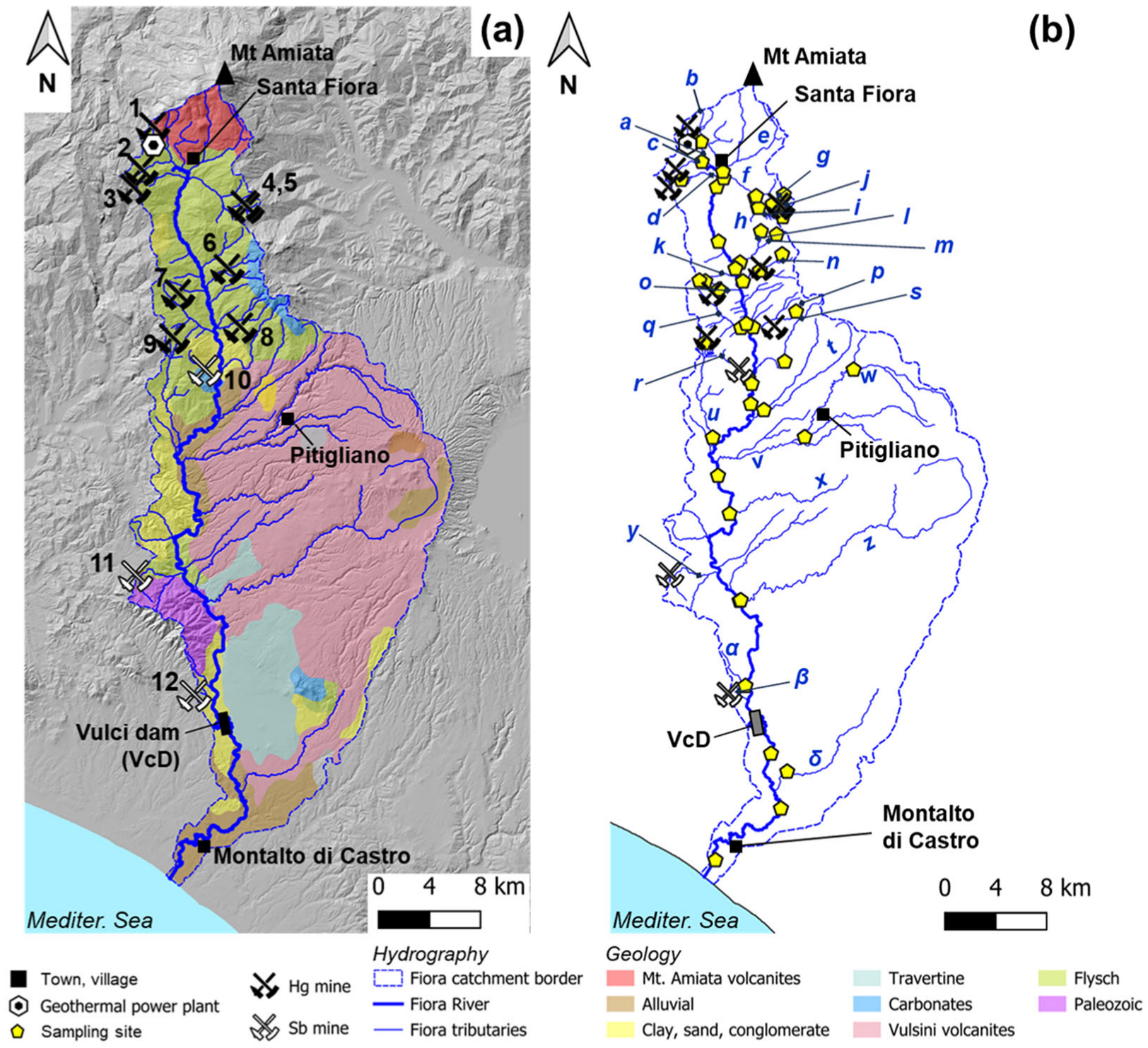
3.3. Mining in the Fiora River Catchment

Eleven dismissed mining and smelting sites are present in the upstream part of the Fiora River (FR) catchment (Figure 1 and Figure 2; Table 1), including the second (ASRS) and the third (Morone) most important Hg production centers of the MAMD, which accounted for 1/3 of the total Hg production of the district. The other sites were of lower importance due to low Hg grades in the local orebodies [53,56]. The catchment receives runoff also from the Montauto mining site (“11” in Figure 2) and possibly from the Podere Pietricci site (“12” in Figure 2) belonging to the Southern Tuscany Sb mineralized district [70,71,72]. The environmental impact of the mine sites on the Fiora River catchment was observed for some trace metals (Hg, Sb, and As) in a previous study, showing the role of the river in the redistribution of contaminants along the catchment [30]. Mass load estimations revealed that at least 0.4, 2.2, and 1.8 t/y of Hg, As, and Sb, respectively, could be released into the Mediterranean Sea [30].

4. Materials and Methods
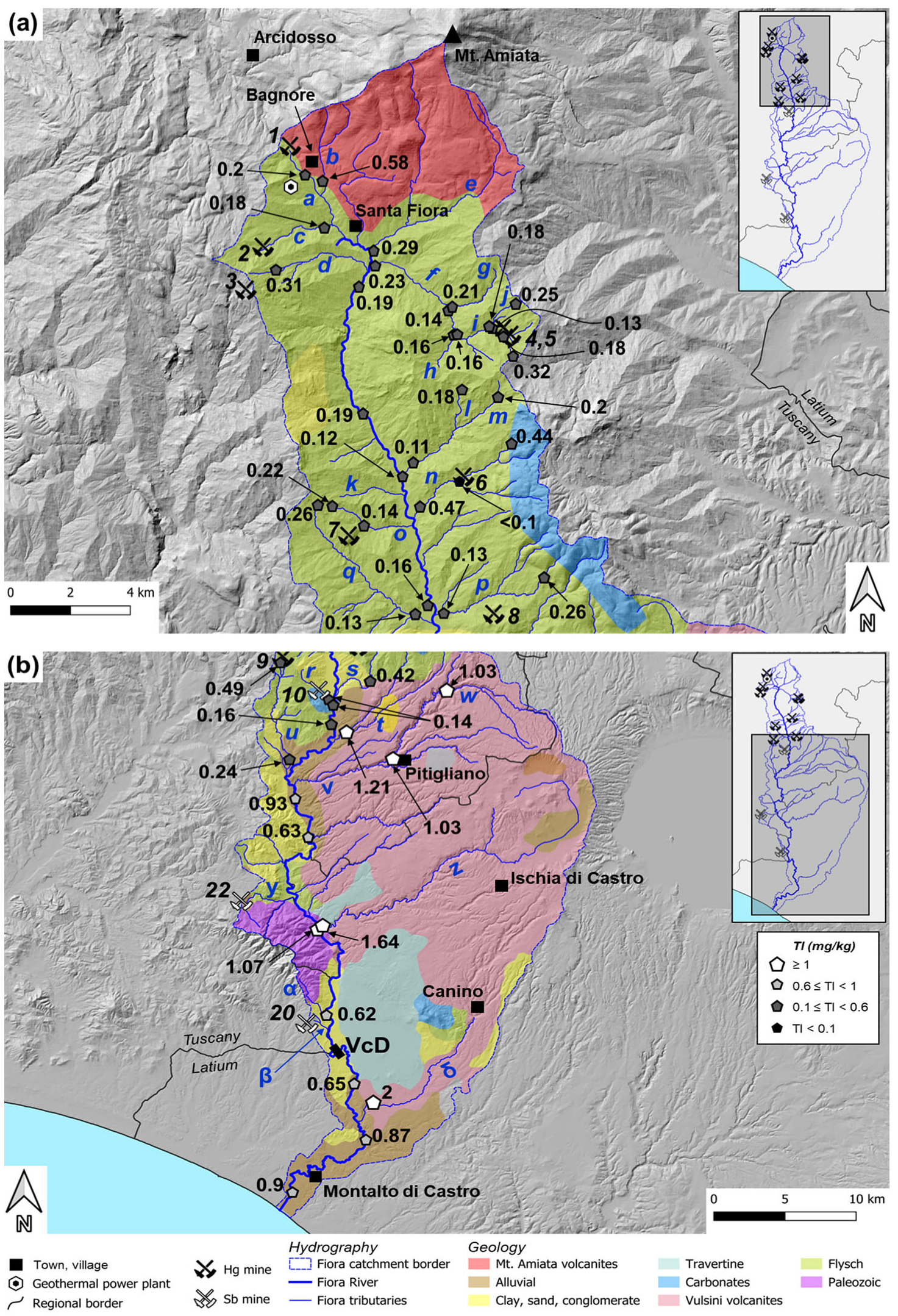
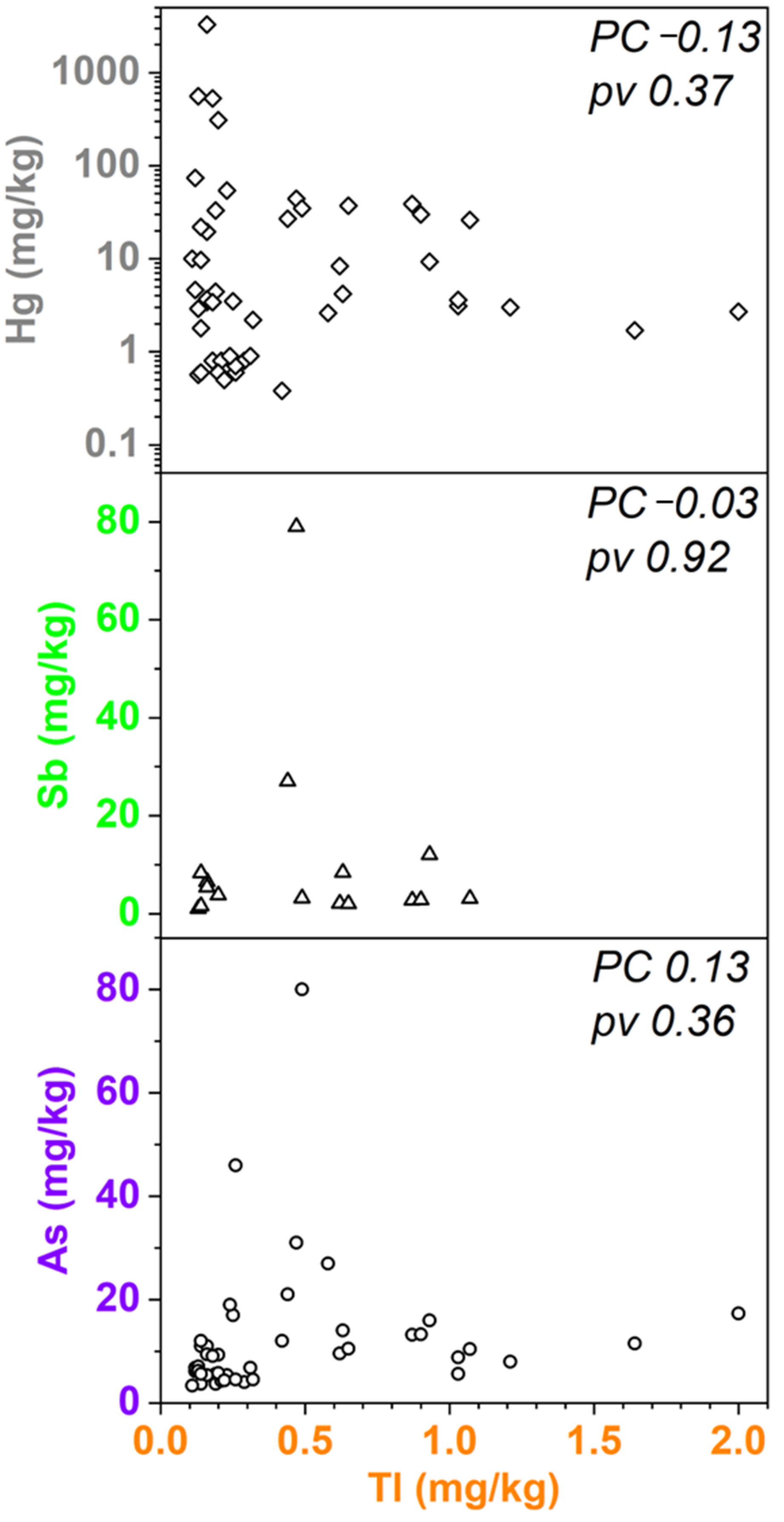
Stream samples were collected in 2022 along the FR main course from the source to the river mouth, as well as on its active tributaries. The sediments were collected in plastic bags with a Teflon spoon in the first 5–10 cm layer in riffles and pools along the active watercourse. All samples are composite of 5 subsamples collected within 5 m2. In total, 15 samples were collected along the FR main stretch; 35 samples were collected in the FR tributaries. For each mine-impacted tributary, at least two samples were collected, respectively, upstream and downstream of the mining site (Table 1). For secondary tributaries (i.e., less than 3 km long and not draining mining areas), one sample was collected immediately upstream of the confluence in the FR.
Sample preparation and analysis were carried out in the ARPAT laboratory in Siena. The samples were air dried at 20–25 °C, homogenized, and sieved with a 2 mm sieve to remove the gravel fraction, according to the Italian national guidelines [73]. Then, the samples were pulverized with a rotating agate ball mortar to less than 0.063 mm fraction. The sediment powders were digested by inverse aqua regia in a microwave oven prior to analysis [74]. Total Tl concentrations were analyzed following the EPA 6020B method [75]. The analyses were carried out by means of an ICP-MS IcapQ Thermo-Fisher (Thermo Fisher Scientific Inc., Waltham, MA, USA) in CCT mode (KEDS). The laboratory uses limit of quantification (LOQ, 0.1 mg/kg for Tl) instead of the LOD, assumed from the first readable point in the calibration curve and checked at the beginning of each analytical run by means of referenced certified material (CRM052 Trace Metals—Loamy Clay 1). The laboratory is subjected to periodical quality checks by an independent organization (Accredia, Rome, Italy) according to the standard ISO/IEC 17025 [76], and it takes part in the SNPA interlaboratory network for cross-checking. The overall analytical precision of the method is <10%, as determined by replicate analyses of different aliquots of the same bulk sample.
The total Tl fluxes (yearly mass loads) through the Vulci Dam over almost a century (from 1923 to 2012) were calculated based on data in the ENEL technical report for the Vulci Dam renovation [69]. Specifically, the ENEL report provides data that allow calculation of the total sediment mass accumulated in the reservoir. This sediment mass is divided by 89 (the years elapsed between 1923 and 2012) to obtain an estimate of the yearly mass of transported sediments. By multiplying the yearly mass load by the median Tl concentration in stream sediments across the catchment (0.2 mg/kg), an estimate of the yearly Tl flux is obtained. Further details for the mass load calculation can be found in Nannoni et al. [30].
The geoaccumulation index (Igeo [18,77,78]) for Tl was calculated across the catchment. This index provides information about the degree of anthropogenic enrichment of an element by comparison with its natural background levels. The index is calculated as follows:
Igeo = ln [Cn/(1.5 × Bn)],
where Cn is the concentration of the element n in the sample and Bn is the natural background of the same element. The natural background for Tl was chosen as the median (1.95 mg/kg) of the concentration range found in the stream sediments of the Southern Tuscany–Northern Latium area, as calculated by [77]. This value was chosen because the whole of Central Italy has a Tl anomaly and a local natural background is to be preferred with respect to a national/European-scale value.

5. Results

Overall, Tl concentration varied between <0.1 and 2 mg/kg (Supplementary Materials) in the stream sediments of the FR catchment, with mean and median values of 0.23 and 0.42 mg/kg, respectively. Thallium concentration along the FR main course was <0.3 mg/kg in the upstream stretch (ca. 30 km from the river mouth), from Santa Fiora down to the confluence of the Lente stream (“v”, Figure 3 and Figure 4).
From the latter tributary confluence to FR mouth, Tl increased between 0.62 and 1.07 mg/kg, with a median value of 0.87 mg/kg (Figure 3). The highest concentration along the main stretch was found after the confluence of the Olpeta stream (“z”), ca. 50 km from the river mouth.
Thallium varied between 0.13 (Solforate cr., “i”) and 0.58 mg/kg (Famelico cr., “b”) in the upstream tributaries (Figure 4a). In the mid-section of the catchment, Tl ranged between <0.1 and 0.49 mg/kg along the tributaries that drain former mining sites, whereas creeks from the Latera–Bolsena volcanic area showed Tl concentrations between 0.42 and 2 mg/kg (“s” to “δ”, Figure 4b), with a median value of 1.12 mg/kg, i.e., exceeding the Italian concentration threshold for public green soils (“CSC”, 1 mg/kg; no threshold is defined for stream sediments in the Italian regulation [73]). Thallium varied between 0.13 (Solforate cr., “i”) and 0.58 mg/kg (Famelico cr., “b”) in the upstream tributaries (Figure 4a). In the mid-section of the catchment, Tl ranged between <0.1 and 0.49 mg/kg along the tributaries that drain former mining sites, whereas creeks from the Latera–Bolsena volcanic area showed Tl concentrations between 0.42 and 2 mg/kg (“s” to “δ”, Figure 4b), with a median value of 1.12 mg/kg, i.e., exceeding the CSC.
Thallium concentration in the FR stream sediments was compared with Hg, Sb, and As concentrations in the same samples measured by [30]. The Pearson’s correlation coefficient was always below 0.2 and the p-values (>>0.05) indicate no significant statistical correlation with the three elements (Figure 5).
The Igeo index varied between −4.7 and −0.5 across the catchment, with a median value of −3.6 (Table S1, Supplementary Materials). The index was always below 0, which corresponds to the “uncontaminated” class (i.e., with no anthropic inputs [18,77]).
Based on the total mass of sediments in the Vulci Dam and the median concentration of Tl in the whole catchment (0.2 mg/kg), it is estimated that the potential Tl flux discharged by the Fiora River into the Mediterranean Sea is in the order of 0.1 t/y. This is a non-negligible amount and suggests the opportunity of additional studies on the sources and transport of this metal.

6. Discussion

Thallium values in this study were below the CSC (1 mg/kg [73]) in most of the FR catchment, with a mean value of 0.43 mg/kg, which is in the same range as the Tl concentration reported for the Earth’s crust (0.49–0.75 mg/kg [33,34,35]) and the mean value for European stream sediments (0.477 mg/kg [79]). A national-scale assessment showed that Tl ranged between 0.01 and 5.62 mg/kg in Italian stream sediments, with a median value of 0.37 mg/kg [79]. The most anomalous (>2 mg/kg) concentrations in stream sediments are found in (1) the Latium volcanic area [79]; (2) near the border with Austria and Slovenia [79,80], in spatial association to the former Raibl Pb-Zn mine; and (3) in the streams draining the orebodies of the Apuan Alps in northern Tuscany [13,31]. Therefore, the Tl median value for the FR was slightly higher than the national value but lower than the European one. Thallium concentrations above the CSC were observed by [32] in several Southern Tuscany soils, including both soils around mining areas (reported range: 1.6–6.1 mg/kg) and soils developed over acid to intermediate magmatic rocks (reported range: 1.8–5.7 mg/kg). At the national scale, Tl in soils (median value: 0.75 mg/kg [79]) exceeds the CSC in several areas. Again, the highest values (>2 mg/kg, up to 6.1 mg/kg) occur in the Latium–Campanian volcanic areas [79].
Thallium showed an interesting trend across the FR catchment. In the sectors draining the mines, Tl contents are comparatively low, whereas the highest concentrations (up to 2 mg/kg, i.e., above the CSC) were found in the tributaries that drain the high-K volcanic rocks cropping out in the Latera–Bolsena area, which is part of the Vulsini volcanic province [65,80,81,82], and downstream of their confluence in the FR. Moreover, if Tl contents are plotted against As, Hg, and Sb contents in the same samples (Figure 5), no significant correlation is observed (p >> 0.05). Therefore, the former Hg-Sb mines cannot represent the only source of Tl in the catchment. Pyrite/marcasite, a common source of Tl [43], are frequent accessory phases in the ores of Morone, Reto, and S. Martino sul Fiora mines [83]. However, no data are available on their Tl content, except for a single analysis by [31] of marcasite from the Bagnore mine in the northernmost section of the Fiora River catchment (Figure 1 and Figure 2). This sample returned a comparatively low Tl concentration (0.11 mg/kg). Higher concentrations of Tl were reported by [31] in marcasite/pyrite samples from the other catchments that drain the MAMD (201, 0.7–252, and 24 mg/kg in the Orcia, Paglia, and Albegna catchments, respectively); an even higher (3880 mg/kg) value was reported in a single sample from the Tafone Sb mine (drained by the Tafone creek, flowing directly to the Tyrrhenian Sea). Recent studies showed that a Tl fraction can be dissolved and then scavenged by the Fe-Mn oxide fraction close to sulfide mine areas, but most of the element is found in the residual fraction, particularly in stream sediments (e.g., [84,85]). Moreover, Tl-rich acid mine drainage waters (AMD) were found directly at the pollution source, e.g., acidic seeps and pools linked to mine workings, tailings piles, or mineralization outcrops. Conversely, runoff waters flowing through mining areas are usually depleted in Tl compared to AMD waters due to scavenging ([40] and references therein, [86]). This process should lead to a Tl enrichment in stream sediments with respect to water downstream of mining areas of sulfide ores. The low Tl grade in the local sulfide ores in the upstream section of the Fiora River catchment and, consequently, the low availability of Tl for weathering processes might explain the low Tl enrichment in the upstream Fiora sediments. It is, however, apparent that additional data (e.g., Tl speciation) are required to ascertain all the processes involved in Tl dispersion in the area.
The spatial correlation of high-Tl sediments collected in the FR catchment with sectors draining the Vulsini ultrapotassic volcanic province [65,80,81,82], where no known mineral deposits occur, suggests these magmatic rocks as the most likely additional/alternative source. High-K rocks may contain non-negligible Tl amounts because of the similar ionic radii of Tl+ and K+ [87]. Potassic and ultrapotassic magmatic rocks undergo Tl enrichment mostly through magmatic evolution, as demonstrated for several magmatic districts (e.g., [87] and references therein, [88]). In general, Tl behaves as an incompatible element and, therefore, is more concentrated in felsic magmas than in mafic ones (e.g., [87] and references therein); the average Tl concentration in 18 felsic rocks analyzed by [86] is 4.63 mg/kg. Biotite and K-feldspar are the typical Tl-bearing phases [87]; however, in silica-undersaturated rocks, leucite may be the main Tl host [89]. Consequently, these rocks can be a preferential, primary source of Tl. In the study area, weathering of K-silicates as a Tl source would be in agreement with data from another Italian ultrapotassic volcanic province, Roccamonfina (Northern Campania), where the groundwater is not enriched in Tl despite its availability due to weathering of high-K volcanic rocks, because it is scavenged by Fe- and Mn-bearing sediments [90]. However, no data of the Tl content of the ultrapotassic rocks cropping out in our study area are available. South of the study area (40 km), in the Tolfa volcanic province, Tl concentrations up to 2.7 mg/kg were measured in unaltered acidic volcanic rocks, whereas 28 mg/kg and 74 mg/kg were found in pyrite and iron gossan, respectively [89]. High Tl concentrations (from 0.05 to 15 mg/kg) were found by [91] in the stream sediments of the Mignone River catchment, which partially developed over the volcanic products of the Tolfa and Sabatini districts, 20 km SE of the study area. However, those authors did not discuss Tl sources and distribution in the Mignone catchment.
In summary, Tl distribution in the Fiora River catchment seems to partly reflect the dual source of this element observed at the global scale. We already mentioned the Italian examples of Tl dispersion from sulfide mines [13,31,92]. Regarding European sulfide ores, the abandoned mine wastes near the Verdugal and La Mónica arsenopyrite–pyrite deposits (N-NW of Madrid, Spain) caused the pollution of surrounding soils and stream sediments (Tl up to 2.65 mg/kg [41]). Contamination was related to the physical alteration of mineralized rocks, natural erosion, and later pedogenic processes, with Tl bound to the residual silicate fraction [41]. The As-Sb-Tl hydrothermal ore of Allchar, Macedonia, is classified as a large reserve for Tl (over 500 t). Active hydrothermal alteration of the orebodies resulted in widespread Tl pollution in soils (range = 0.11–20,000 mg/kg, median = 5.2 mg/kg) and stream sediments (range = 0.78–25 mg/kg, median = 17 mg/kg for the samples collected downstream of the alteration zone [93]), whereas mining activity had moderate consequences for Tl contamination (mining was locally important only for Sb [93]). The stream sediments collected in the Pb-Zn sulfide Silesian district (Poland) showed Tl concentrations ranging from 1.49 to 147 mg/kg in the vicinity of the processing area; the element is preferentially associated with the oxidizable fraction, whereas the residual fraction controls Tl concentration in local soils [36,41]. Mineral processing was recognized as the primary cause of Tl enrichment in the district, followed by the weathering of outcropping ores [36]. At the global scale, the most prominent example is the peculiar Tl-rich sulfide deposit of Lanmuchang, China; stream sediments in the affected area have Tl contents as high as 72 mg/kg; pollution is related to both mining activity and natural weathering of Tl-rich minerals [94]. The Western Pearl River Basin (China) hosts one of the world’s largest pyrite ore, and smelting is carried out onsite. Thallium concentrations up to 17.3 mg/kg were found in the stream sediments that were collected in the first 5 km downstream of the mine and their connection with mining activity was confirmed (the local natural background concentration is 0.55 mg/kg [37,95]). Moreover, most Tl in the stream sediments was associated primarily with the residual fraction (>65%) and secondarily with the Fe-Mn fraction, indicating that the migration of Tl from these sediments is weak [37,95]. A similar low mobility of Tl is reported for stream sediments near a sulfide metal mine in the UK [96].
A deeper understanding of Tl distribution in the Fiora River catchment would require specific studies of Tl abundance and speciation in mines, sediments, and magmatic rocks. Studies of Tl speciation would be crucial also to determine the bioavailability of the metal and its potential environmental and health impact.
Therefore, the results of this study suggest the opportunity for further investigation on the occurrence and potential Tl release from catchments draining the MAMD and/or high-K magmatic rocks. Thallium pollution should be addressed carefully, since it is one of the most toxic metals and it may cause more severe acute and chronic poisoning effects than Hg, Pb, Cd, and Zn for human health [97,98]. In fact, it is easily transferred from the geosphere to the biosphere due to Tl+ affinity with K+ [42,99,100].
The estimated particle-bound Tl mass loads released by the Fiora River (0.1 t/y) are similar to the amount (0.14 t/y) discharged in the Atlantic Ocean by the Rio Tinto River, draining the well-known mining district of the Iberian Pyrite belt, SW Spain [101]. A total budget of 2.7 t/y was estimated for particle-bound Tl discharged in the Bohai Bay (N China) by multiple rivers; such input was related primarily to natural and secondarily to anthropogenic sources [102]. However, it should be noted that the Tl fluxes from the FR could be even higher, considering that sediment removal operations were carried out after the building of the Vulci Dam. The flux cannot be compared with other catchments of the MAMD, because no data are available at present. Further investigations are required to assess the total Tl flux from the MAMD and the Sb district; the Tafone Creek and the Albegna River drain Sb ores that contain non-negligible amounts of Tl, which could contribute to the Mediterranean Tl budget. Additionally, the Paglia River drains part of the MAMD and a part of the Latium high-K volcanic rocks in its downstream section; therefore, its contribution to Tl discharge to the Mediterranean basin cannot be ruled out at this stage.

7. Conclusions

The present study revealed that the Fiora River catchment (Tuscany, Italy) represents a non-negligible contributor to the Tl budget of the Mediterranean Sea. In sediments of creeks draining the mining areas of the dismissed Hg and Sb mine districts, Tl varied between 0.1 and 0.4 mg/kg. However, Tl distribution does not match that of other toxic elements such as Hg, As, and Sb, whose diffusion was attributed by previous studies to the past mining activities. The highest values (up to 2 mg/kg) were found in the tributaries which drain the Vulsini volcanic province, suggesting high-K magmatic rocks as an additional/alternative source of this metal in the catchment.
A preliminary estimation of Tl mass loads indicates that up to 0.1 t/y could be discharged into the Mediterranean Sea from the Fiora River catchment. This figure is presumably just a small part of a possibly much larger phenomenon. A regional-scale budget should include other catchments draining other Hg and Sb mines, where Tl could be more abundant, and/or high-K magmatic rocks. Consequently, further investigation should be carried out to (1) clarify the Tl mineralogical speciation in the source(s) and in the sediments to make inferences on its bioavailability and potential ecological impact; (2) monitor Tl mass loads from these catchments and quantify the seasonal variability of pollutant discharge to the sea in different hydrological conditions, in view of the extreme weather events caused by climate change. This information is critical to assess the environmental impact on a biodiversity hotspot such as the Mediterranean Sea and to plan proper mitigation measures.

Supplementary Materials

The following supporting information can be downloaded at: https://www.mdpi.com/article/10.3390/min15070678/s1, Table S1: Stream sediment data collected in 2022.

Author Contributions

Conceptualization, A.N. and P.L.; methodology, A.N., R.F., and A.N.; validation, A.N., R.F., P.C., P.L., and C.F.; formal analysis, A.N. and R.F.; investigation, A.N., G.M., V.R., P.L., and P.C.; resources, V.R. and C.F.; data curation, A.N.; writing—original draft preparation, A.N.; writing—review and editing, A.N., G.M., V.R., P.C., P.L., R.F., and C.F.; visualization, A.N.; supervision, V.R., P.C., and P.L.; project administration, A.N., V.R., and P.C.; funding acquisition, V.R., C.F., and P.C. All authors have read and agreed to the published version of the manuscript.

Funding

This research was funded by a research agreement between ARPAT (responsible: C.F.) and Università di Firenze (responsible: V.R.).

Data Availability Statement

All data for this study are provided within the main text. Additional information may be obtained from the corresponding authors upon reasonable request.

Acknowledgments

We thank the constructive criticism of three anonymous reviewers.

Conflicts of Interest

The authors declare no conflicts of interest. The funders had no role in the design of the study; in the collection, analyses, or interpretation of data; in the writing of the manuscript; or in the decision to publish the results.

Abbreviations

The following abbreviations are used in this manuscript:
MAMDMonte Amiata Mining District
ASSMAbbadia San Salvatore mine
ASRSAbetina-Solforate-Rosselli-Schwarzenberg mines
FRFiora River
VcDVulci Dam
CSCItalian concentration threshold for public soils of an element

References

  1. Macklin, M.G.; Brewer, P.A.; Hudson-Edwards, K.A.; Bird, G.; Coulthard, T.J.; Dennis, I.A.; Lechler, P.J.; Miller, J.R.; Turner, J.N. A geomorphological approach to the management of rivers contaminated by metal mining. Geomorphology 2006, 79, 423–447. [Google Scholar] [CrossRef]
  2. Costagliola, P.; Benvenuti, M.M.; Benvenuti, M.G.; Di Benedetto, F.; Lattanzi, P. Quaternary sediment geochemistry as a proxy for toxic element source: A case study of arsenic in the Pecora Valley (southern Tuscany, Italy). Chem. Geol. 2010, 270, 80–89. [Google Scholar] [CrossRef]
  3. Milačič, R.; Ščančar, J.; Murko, S.; Kocman, D.; Horvat, M. A complex investigation of the extent of pollution in sediments of the Sava River. Part 1: Selected elements. Environ. Monit. Assess. 2010, 163, 263–275. [Google Scholar] [CrossRef]
  4. Salomons, W. Environmental impact of metals derived from mining activities: Processes, predictions, prevention. J. Geochem. Explor. 1995, 52, 5–23. [Google Scholar] [CrossRef]
  5. Ashley, P.M.; Graham, B.P.; Tighe, M.K.; Wolfenden, B.J. Antimony and arsenic dispersion in the Macleay River catchment, New South Wales: A study of the environmental geochemical consequences. Aust. J. Earth Sci. 2007, 54, 83–103. [Google Scholar] [CrossRef]
  6. Bird, G.; Brewer, P.A.; Macklin, M.G.; Nikolova, M.; Kotsev, T.; Mollov, M.; Swain, C. Dispersal of contaminant metals in the mining-affected Danube and Maritsa drainage basins, Bulgaria, Eastern Europe. Water Air Soil Pollut. 2010, 206, 105–127. [Google Scholar] [CrossRef]
  7. Byrne, P.; Reid, I.; Wood, P.J. Sediment geochemistry of streams draining abandoned lead/zinc mines in central Wales: The Afon Twymyn. J. Soils Sediments 2010, 10, 683–697. [Google Scholar] [CrossRef]
  8. Möller, S.; Einax, J.W. Metals in sediments—Spatial investigation of Saale River applying chemometric tools. Microchem. J. 2013, 110, 233–238. [Google Scholar] [CrossRef]
  9. Lecce, S.A.; Pavlowsky, R.T. Floodplain storage of sediment contaminated by mercury and copper from historic gold mining at Gold Hill, North Carolina, USA. Geomorphology 2014, 206, 122–132. [Google Scholar] [CrossRef]
  10. Resongles, E.; Casiot, C.; Freydier, R.; Dezileau, L.; Viers, J.; Elbaz-Poulichet, F. Persisting impact of historical mining activity to metal (Pb, Zn, Cd, Tl, Hg) and metalloid (As, Sb) enrichment in sediments of the Gardon River, Southern France. Sci. Total Environ. 2014, 481, 509–521. [Google Scholar] [CrossRef]
  11. Wohl, E. Legacy effects on sediments in river corridors. Earth Sci. Rev. 2015, 147, 30–53. [Google Scholar] [CrossRef]
  12. Lynch, S.F.L.; Batty, L.C.; Byrne, P. Environmental risk of severely Pb-contaminated riverbank sediment as a consequence of hydrometeorological perturbation. Sci. Total Environ. 2018, 636, 1428–1441. [Google Scholar] [CrossRef] [PubMed]
  13. Ghezzi, L.; Buccianti, A.; Giannecchini, R.; Guidi, M.; Petrini, R. Geochemistry of mine Stream sediments and the control on potentially toxic element migration: A case study from the Baccatoio Basin (Tuscany, Italy). Mine Water Environ. 2021, 40, 722–735. [Google Scholar] [CrossRef]
  14. Ponting, J.; Kelly, T.J.; Verhoef, A.; Watts, M.J.; Sizmur, T. The impact of increased flooding occurrence on the mobility of potentially toxic elements in floodplain soil–A review. Sci. Total Environ. 2021, 754, 142040. [Google Scholar] [CrossRef]
  15. Zhang, L.; Yang, Z.; Wang, Q.; Guo, F.; Song, Y.; Han, W.; Peng, M.; Liu, F.; Li, K.; Cheng, H. Temporal and spatial accumulation of potentially toxic elements (PTEs) in stream sediments from a large lead–zinc mine concentration area of Baoshan, Southwest China. J. Soils Sediments 2022, 22, 2290–2308. [Google Scholar] [CrossRef]
  16. Onnis, P.; Byrne, P.; Hudson-Edwards, K.A.; Stott, T.; Hunt, C.O. Fluvial Morphology as a Driver of Lead and Zinc Geochemical Dispersion at a Catchment Scale. Minerals 2023, 13, 790. [Google Scholar] [CrossRef]
  17. Nriagu, J.O.; Pacyna, J.M. Quantitative assessment of worldwide contamination of air, water and soils by trace metals. Nature 1988, 333, 134–139. [Google Scholar] [CrossRef]
  18. Barbieri, M.; Sappa, G.; Nigro, A. Soil pollution: Anthropogenic versus geogenic contributions over large areas of the Lazio region. J. Geochem. Explor. 2018, 195, 78–86. [Google Scholar] [CrossRef]
  19. Barghigiani, C.; Ristori, T. Preliminary Results on the Role of Rivers in Total Hg Concentrations in Marine Sediments and Benthic Organisms of a Coastal Area of Italy. In Mercury as a Global Pollutant; Porcella, D.B., Huckabee, J.W., Wheatley, B., Eds.; Springer: Dordrecht, The Netherlands, 1995; pp. 111–120. [Google Scholar] [CrossRef]
  20. Gray, J.E.; Rimondi, V.; Costagliola, P.; Vaselli, O.; Lattanzi, P. Long-distance transport of Hg, Sb, and As from a mined area, conversion of Hg to methyl-Hg, and uptake of Hg by fish on the Tiber River basin, west-central Italy. Environ. Geochem. Health 2014, 36, 145–157. [Google Scholar] [CrossRef]
  21. Montuori, P.; Aurino, S.; Garzonio, F.; Nardone, A.; Triassi, M. Estimation of heavy metal loads from Tiber River to the Tyrrhenian Sea and environmental quality assessment. Environ. Sci. Pollut. Res. 2016, 23, 23694–23713. [Google Scholar] [CrossRef]
  22. Chiarantini, L.; Benvenuti, M.; Beutel, M.; Costagliola, P.; Covelli, S.; Gabbani, G.; Lattanzi, P.; Pandeli, E.; Paolieri, M.; Petranich, E.; et al. Mercury and arsenic in stream sediments and surface waters of the Orcia River basin, southern Tuscany, Italy. Water Air Soil Pollut. 2016, 227, 408. [Google Scholar] [CrossRef]
  23. Scanu, S.; Piazzolla, D.; Frattarelli, F.M.; Mancini, E.; Tiralongo, F.; Brundo, M.V.; Tibullo, D.; Pecoraro, R.; Copat, C.; Ferrante, M.; et al. Mercury enrichment in sediments of the coastal area of northern Latium, Italy. Bull. Environ. Contam. Toxicol. 2016, 96, 630–637. [Google Scholar] [CrossRef]
  24. Rimondi, V.; Costagliola, P.; Lattanzi, P.; Morelli, G.; Cara, G.; Cencetti, C.; Fagotti, C.; Fredduzzi, A.; Marchetti, G.; Sconocchia, A.; et al. A 200 km-long mercury contamination of the Paglia and Tiber floodplain: Monitoring results and implications for environmental management. Environ. Pollut. 2019, 255, 113191. [Google Scholar] [CrossRef]
  25. Colica, A.; Benvenuti, M.; Chiarantini, L.; Costagliola, P.; Lattanzi, P.; Rimondi, V.; Rinaldi, M. From point source to diffuse source of contaminants: The example of mercury dispersion in the Paglia River (Central Italy). Catena 2019, 172, 488–500. [Google Scholar] [CrossRef]
  26. Fornasaro, S.; Morelli, G.; Rimondi, V.; Fagotti, C.; Friani, R.; Lattanzi, P.; Costagliola, P. The extensive mercury contamination in soil and legacy sediments of the Paglia River basin (Tuscany, Italy): Interplay between Hg-mining waste discharge along rivers, 1960s economic boom, and ongoing climate change. J. Soils Sedim. 2022, 22, 656–671. [Google Scholar] [CrossRef]
  27. Fornasaro, S.; Morelli, G.; Costagliola, P.; Rimondi, V.; Lattanzi, P.; Fagotti, C. Total Mercury Mass Load from the Paglia–Tiber River System: The Contribution to Mediterranean Sea Hg Budget. Toxics 2022, 10, 395. [Google Scholar] [CrossRef]
  28. Meloni, F.; Montegrossi, G.; Lazzaroni, M.; Rappuoli, D.; Nisi, B.; Vaselli, O. Total and leached arsenic, mercury and antimony in the mining waste dumping area of Abbadia San Salvatore (Mt. Amiata, Central Italy). Appl. Sci. 2021, 11, 7893. [Google Scholar] [CrossRef]
  29. Meloni, F.; Nisi, B.; Gozzi, C.; Rimondi, V.; Cabassi, J.; Montegrossi, G.; Rappuoli, D.; Vaselli, O. Background and geochemical baseline values of chalcophile and siderophile elements in soils around the former mining area of Abbadia San Salvatore (Mt. Amiata, southern Tuscany, Italy). J. Geochem. Explor. 2023, 255, 107324. [Google Scholar] [CrossRef]
  30. Nannoni, A.; Morelli, G.; Lattanzi, P.; Fagotti, C.; Friani, R.; Fornasaro, S.; Ciani, F.; Manca, R.; Monnanni, A.; Rimondi, V.; et al. Toxic trace elements transport in stream sediments from the world-class Monte Amiata Hg mining district: Potential impact to the Mediterranean Sea. Environ. Pollut. 2025, 372, 126088. [Google Scholar] [CrossRef]
  31. D’Orazio, M.; Biagioni, C.; Dini, A.; Vezzoni, S. Thallium-rich pyrite ores from the Apuan Alps, Tuscany, Italy: Constraints for their origin and environmental concerns. Miner. Depos. 2017, 52, 687–707. [Google Scholar] [CrossRef]
  32. Pisani, A.; Protano, G.; Riccobono, F. Contenuti e distribuzione del tallio in suoli e piante spontanee della Toscana meridionale. In Codice Armonico 2008; Edizioni ETS: Pisa, Italy, 2008; Volume 1, pp. 122–129. (In Italian) [Google Scholar]
  33. Wedepohl, K.H. The composition of the continental crust. Geochim. Cosmochim. Acta 1995, 59, 1217–1232. [Google Scholar] [CrossRef]
  34. Rudnick, R.L.; Gao, S. Composition of the continental crust. In The Crust-Treatise on Geochemistry; Rudnick, R.L., Ed.; Elsevier: Amsterdam, The Netherlands, 2003. [Google Scholar]
  35. Kabata-Pendias, A. Trace Elements in Soils and Plants; CRC Press: Boca Raton, FL, USA, 2011. [Google Scholar]
  36. Karbowska, B.; Zembrzuski, W.; Jakubowska, M.; Wojtkowiak, T.; Pasieczna, A.; Lukaszewski, Z. Translocation and mobility of thallium from zinc–lead ores. J. Geochem. Explor. 2014, 143, 127–135. [Google Scholar] [CrossRef]
  37. Liu, J.; Wang, J.; Chen, Y.; Shen, C.-C.; Jiang, X.; Xie, X.; Chen, D.; Lippold, H.; Wang, C. Thallium dispersal and contamination in surface sediments from South China and its source identification. Environ. Pollut. 2016, 213, 878–887. [Google Scholar] [CrossRef]
  38. Belzile, N.; Chen, Y.W. Thallium in the environment: A critical review focused on natural waters, soils, sediments and airborne particles. Appl. Geochem. 2017, 84, 218–243. [Google Scholar] [CrossRef]
  39. Liu, J.; Ren, S.; Zhou, Y.; Tsang, D.C.W.; Lippold, H.; Wang, J.; Yin, M.; Xiao, T.; Luo, X.; Chen, Y. High contamination risks of thallium and associated metal(loid)s in fluvial sediments from a steel-making area and implications for environmental management. J. Environ. Manag. 2019, 250, 109513. [Google Scholar] [CrossRef]
  40. Migaszewski, Z.M.; Gałuszka, A. Abundance and fate of thallium and its stable isotopes in the environment. Rev. Environ. Sci. Biotechnol. 2021, 20, 5–30. [Google Scholar] [CrossRef]
  41. Gómez-González, M.A.; García-Guinea, J.; Laborda, F.; Garrido, F. Thallium occurrence and partitioning in soils and sediments affected by mining activities in Madrid province (Spain). Sci. Total Environ. 2015, 536, 268–278. [Google Scholar] [CrossRef] [PubMed]
  42. Karbowska, B. Presence of thallium in the environment: Sources of contaminations, distribution and monitoring methods. Environ. Monit. Assess. 2016, 188, 640. [Google Scholar] [CrossRef]
  43. Li, N.; Zhou, Y.; Liu, J.; Tsang, D.C.W.; Wang, J.; She, J.; Zhou, Y.; Yin, M.; Chen, Z.; Chen, D. Persistent thallium contamination in river sediments, source apportionment and environmental implications. Ecotoxicol. Environ. Saf. 2020, 202, 110874. [Google Scholar] [CrossRef]
  44. Sun, F.; Tao, Y.; Liao, H.; Wu, F.; Giesy, J.P.; Yang, J. Pollution levels and risk assessment of thallium in Chinese surface water and sediments. Sci. Total Environ. 2022, 851, 158363. [Google Scholar] [CrossRef]
  45. Galván-Arzate, S.; Santamaría, A. Thallium toxicity. Toxicol. Lett. 1998, 99, 1–13. [Google Scholar] [CrossRef] [PubMed]
  46. Martin, F.; Garcia, I.; Dorronsoro, C.; Simón, M.; Aguilar, J.; Fernández, E.; Irabien, A.; Fernández, J. Thallium behavior in soils polluted by pyrite tailings (Aznalcollar, Spain). Soil Sediment Contam. 2004, 13, 25–36. [Google Scholar] [CrossRef]
  47. Tatsi, K.; Turner, A. Distributions and concentrations of thallium in surface waters of a region impacted by historical metal mining (Cornwall, UK). Sci. Total Environ. 2014, 473, 139–146. [Google Scholar] [CrossRef]
  48. Casiot, C.; Egal, M.; Bruneel, O.; Verma, N.; Parmentier, M.; Elbaz-Poulichet, F. Predominance of aqueous Tl (I) species in the river system downstream from the abandoned Carnoulès mine (Southern France). Environ. Sci. Technol. 2011, 45, 2056–2064. [Google Scholar] [CrossRef]
  49. Xiao, T.; Yang, F.; Li, S.; Zheng, B.; Ning, Z. Thallium pollution in China: A geo-environmental perspective. Sci. Total Environ. 2012, 421, 51–58. [Google Scholar] [CrossRef]
  50. Campanella, B.; Onor, M.; D’Ulivo, A.; Giannecchini, R.; D’Orazio, M.; Petrini, R.; Bramanti, E. Human exposure to thallium through tap water: A study from Valdicastello Carducci and Pietrasanta (northern Tuscany, Italy). Sci. Total Environ. 2016, 548, 33–42. [Google Scholar] [CrossRef] [PubMed]
  51. European Commission. Directive 2000/60/EC of the European Parliament and of the Council of 23 October 2000 Establishing a Framework for Community Action in the Field of Water Policy. Off. J. Eur. Commun. 2000. Available online: https://eur-lex.europa.eu/legal-content/EN/TXT/PDF/?uri=CELEX:02000L0060-20140101 (accessed on 21 June 2025).
  52. Willner, J.; Fornalczyk, A.; Jablonska-Czapla, M.; Grygoyc, K.; Rachwal, M. Studies on the Content of Selected Technology Critical Elements (Germanium, Tellurium and Thallium) in Electronic Waste. Materials 2021, 14, 3722. [Google Scholar] [CrossRef]
  53. Strappa, O. Storia delle miniere di mercurio del M. Amiata. Ind. Mineraria 1977, 28, 252–259. (In Italian) [Google Scholar]
  54. Rimondi, V.; Chiarantini, L.; Lattanzi, P.; Benvenuti, M.; Beutel, M.; Colica, A.; Costagliola, P.; Di Benedetto, F.; Gabbani, G.; Gray, J.E.; et al. Metallogeny, exploitation and environmental impact of the Mt. Amiata mercury ore district (Southern Tuscany, Italy). Ital. J. Geosci. 2015, 134, 323–336. [Google Scholar] [CrossRef]
  55. Nannoni, A.; Meloni, F.; Benvenuti, M.; Cabassi, J.; Ciani, F.; Costagliola, P.; Fornasaro, S.; Lattanzi, P.; Lazzaroni, M.; Nisi, B.; et al. Environmental impact of past Hg mining activities in the Monte Amiata district, Italy: A summary of recent studies. AIMS Geosci. 2022, 8, 525–551. [Google Scholar] [CrossRef]
  56. Dini, A. Miniere e minerali del Distretto mercurifero del Monte Amiata. In Il Vulcano di Monte Amiata; Principe, C., Lavorini, G., Vezzoli, L., Eds.; Pacini Editore: Pisa, Italy, 2017; pp. 343–369. (In Italian) [Google Scholar]
  57. Tanelli, G.; Lattanzi, P. Pyritic ores of southern Tuscany, Italy. Ita. Geol. Soc. S. Afr. Spec. Publ. 1983, 7, 315–323. [Google Scholar]
  58. Lattanzi, P.; Benvenuti, M.; Costagliola, P.; Tanelli, G. An overview on recent research on the metallogeny of Tuscany, with special reference to the Apuane Alps. Mem. Soc. Geol. Ital. 1994, 48, 613–625. [Google Scholar]
  59. Molli, G. Northern Apennine–Corsica orogenic system: An updated overview. Geol. Soc. Lond. Spec. Publ. 2008, 298, 413–442. [Google Scholar] [CrossRef]
  60. Cadoux, A.; Pinti, D.L. Hybrid character and pre-eruptive events of Mt Amiata volcano (Italy) inferred from geochronological, petro-geochemical and isotopic data. J. Volcanol. Geotherm. Res. 2009, 179, 169–190. [Google Scholar] [CrossRef]
  61. Marroni, M.; Moratti, G.; Costantini, A.; Conticelli, S.; Benvenuti, M.G.; Pandolfi, L.; Bonini, M.; Cornamusini, G.; Laurenzi, M.A. Geology of the Monte Amiata region, southern Tuscany, central Italy. Ital. J. Geosci. 2015, 134, 171–199. [Google Scholar] [CrossRef]
  62. Tanelli, G. Mineralizzazioni metallifere e minerogenesi della Toscana. Mem. Soc. Geol. Ital. 1983, 25, 91–109. (In Italian) [Google Scholar]
  63. Brogi, A.; Fabbrini, L. Extensional and strike-slip tectonics across the Monte Amiata–Monte Cetona transect (Northern Apennines, Italy) and seismotectonic implications. Tectonophysics 2009, 476, 195–209. [Google Scholar] [CrossRef]
  64. Brogi, A.; Fabbrini, L.; Liotta, D. Sb–Hg ore deposit distribution controlled by brittle structures: The case of the Selvena mining district (Monte Amiata, Tuscany, Italy). Ore Geol. Rev. 2011, 41, 35–48. [Google Scholar] [CrossRef]
  65. Peccerillo, A. The Roman Province. In Cenozoic Volcanism in the Tyrrhenian Sea Region; Advances in Volcanology; Springer: Cham, Switzerland, 2017. [Google Scholar] [CrossRef]
  66. Autorità di Bacino Interregionale del Fiume Fiora. UoM Fiora ITADBI014: Piano di Gestione del Rischio Alluvioni. Relazione di Piano; Autorità di Bacino Interregionale del Fiume Fiora: Grosseto, Italy, 2015; 108 pp. (In Italian) [Google Scholar]
  67. Geoportale Nazionale. Carta Geolitologica d’Italia; Italian Ministry of the Environment: Rome, Italy, 2016. Available online: https://gn.mase.gov.it/portale/home (accessed on 20 January 2025). (In Italian)
  68. Scanu, S.; De Mendoza, F.P.; Piazzolla, D.; Marcelli, M. Anthropogenic impact on river basins: Temporal evolution of sediment classes and accumulation rates in the northern Tyrrhenian Sea, Italy. Oceanol. Hydrobiol. Stud. 2015, 44, 74–86. [Google Scholar] [CrossRef]
  69. ENEL. Relazioni Tecniche SIPAD n. 1938658—Impianto Idroelettrico di Vulci—Diga di Vulci—Rinnovamento delle Caratteristiche Funzionali e Prestazionali dello Sbarramento di Vulci. Prescrizione g); Technical report for the Evaluation of Environmental Impact (VIA), code prot. DVA/2014/37301; Italian Ministry of the Environment: Rome, Italy, 2016. (In Italian) [Google Scholar]
  70. Dessau, G. Antimony deposits of Tuscany. Econ. Geol. 1952, 47, 397–413. [Google Scholar] [CrossRef]
  71. Dehm, R.M.; Klemm, D.D.; Müller, C.; Wagner, J.; Weber-Diefenbach, K. Exploration for antimony deposits in southern Tuscany, Italy. Miner. Depos. 1983, 18, 423–434. [Google Scholar] [CrossRef]
  72. Klemm, D.D.; Neumann, N. Ore-controlling factors in the Hg-Sb province of southern Tuscany, Italy. In Syngenesis and Epigenesis in the Formation of Mineral Deposits; Wauschkuhn, A., Kluth, C., Zimmermann, R.A., Eds.; Springer: Berlin/Heidelberg, Germany, 1984; pp. 482–503. [Google Scholar] [CrossRef]
  73. D. Lgs 152/06-Legislative Decree. Norme in Materia Ambientale Gazzetta Ufficiale No. 88; Italian Ministry of the Environment: Rome, Italy, 2006. (In Italian) [Google Scholar]
  74. U.S. EPA. Method 3051A (SW-846): Microwave Assisted Acid Digestion of Sediments, Sludges, and Oils, Revision 1; U.S. Environmental Protection Agency: Washington, DC, USA, 2007. [Google Scholar]
  75. U.S. EPA. Method 6020B (SW-846): Inductively Coupled Plasma-Mass Spectrometry; U.S. Environmental Protection Agency: Washington, DC, USA, 2014. [Google Scholar]
  76. ISO/IEC 17025:2017; General Requirements for the Competence of Testing and Calibration Laboratories. International Organization for Standardization: Geneva, Switzerland, 2017.
  77. Barbieri, M. The Importance of Enrichment Factor (EF) and Geoaccumulation Index (Igeo) to Evaluate the Soil Contamination. J. Geol. Geophys. 2016, 5, 1–4. [Google Scholar] [CrossRef]
  78. Looi, L.J.; Aris, A.Z.; Yusoff, F.M.; Isa, N.M.; Haris, H. Application of Enrichment Factor, Geoaccumulation Index, and Ecological Risk Index in Assessing the Elemental Pollution Status of Surface Sediments. Environ. Geochem. Health 2019, 41, 27–42. [Google Scholar] [CrossRef]
  79. Salminen, R.; Batista, M.J.; Bidovec, M.; Demetriades, A.; De Vivo, B.; De Vos, W.; Duris, M.; Gilucis, A.; Gregorauskiene, V.; Halamic, J.; et al. Geochemical Atlas of Europe. Part 1—Background Information, Methodology and Maps; Geological Survey of Finland: Espoo, Finland, 2005. [Google Scholar]
  80. Sparks, R.S.J. Stratigraphy and geology of the ignimbrites of Vulsini Volcano, central Italy. Geol. Rundsch. 1975, 64, 497–523. [Google Scholar] [CrossRef]
  81. Nappi, G.; Antonelli, F.; Coltorti, M.; Milani, L.; Renzulli, A.; Siena, F. Volcanological and petrological evolution of the eastern Vulsini district, central Italy. J. Volcanol. Geotherm. Res. 1998, 87, 211–232. [Google Scholar] [CrossRef]
  82. Conticelli, S.; Perini, G.; Boari, E.; Avanzinelli, R.; Melluso, L. Petrologic and Isotopic characteristics of potassic and ultrapotassic alkalic magmatism in Central-Southern Italy: Inferences on its genesis and on the nature of its mantle source. Period. Mineral. 2004, 73, 136–164. [Google Scholar]
  83. Regione Toscana. Banca Dati Risorse Minerarie (BD_RIMI). Available online: https://www502.regione.toscana.it/geonetwork/srv/ita/catalog.search#/home (accessed on 5 March 2025).
  84. Aguilar-Carrillo, J.; Herrera, L.; Gutiérrez, E.J.; Reyes-Domínguez, I.A. Solid-Phase Distribution and Mobility of Thallium in Mining-Metallurgical Residues: Environmental Hazard Implications. Environ. Pollut. 2018, 243, 1833–1845. [Google Scholar] [CrossRef]
  85. Cruz-Hernández, Y.; Ruiz-García, M.; Villalobos, M.; Romero, F.M.; Meza-Figueroa, D.; Garrido, F.; Pi-Puig, T. Fractionation and Mobility of Thallium in Areas Impacted by Mining-Metallurgical Activities: Identification of a Water-Soluble Tl(I) Fraction. Environ. Pollut. 2018, 237, 154–165. [Google Scholar] [CrossRef]
  86. Alderton, D.H.M.; Serafimovski, T.; Mullen, B.; Fairall, K.; James, S. The Chemistry of Waters Associated with Metal Mining in Macedonia. Mine Water Environ. 2005, 24, 139–149. [Google Scholar] [CrossRef]
  87. Rader, S.T.; Mazdab, F.K.; Barton, M.D. Mineralogical Thallium Geochemistry and Isotope Variations from Igneous, Metamorphic, and Metasomatic Systems. Geochim. Cosmochim. Acta 2018, 243, 42–65. [Google Scholar] [CrossRef]
  88. Hettmann, K.; Marks, M.A.; Kreissig, K.; Zack, T.; Wenzel, T.; Rehkämper, M.; Markl, G. The Geochemistry of Tl and Its Isotopes During Magmatic and Hydrothermal Processes: The Peralkaline Ilimaussaq Complex, Southwest Greenland. Chem. Geol. 2014, 366, 1–13. [Google Scholar] [CrossRef]
  89. Calderoni, G.; Giannetti, B.; Masi, U. Abundance and Behavior of Thallium in the K-Alkaline Rocks from the Roccamonfina Volcano (Campania, Southern Italy). Chem. Geol. 1983, 38, 239–253. [Google Scholar] [CrossRef]
  90. Calderoni, G.; Ferrini, V.; Masi, U. Distribution and significance of Pb and Tl in the sulfides and host rocks from the hydrothermal mineralization of the Tolfa Mountains (Latium, Central Italy). Chem. Geol. 1985, 51, 29–39. [Google Scholar] [CrossRef]
  91. Spadoni, M.; Voltaggio, M.; Cavarretta, G. Recognition of areas of anomalous concentration of potentially hazardous elements by means of a subcatchment-based discriminant analysis of stream sediments. J. Geochem. Explor. 2005, 87, 83–91. [Google Scholar] [CrossRef]
  92. Barago, N.; Pavoni, E.; Floreani, F.; Crosera, M.; Adami, G.; Lenaz, D.; Covelli, S. Environmental impact and mobility of thallium and other metal(oid)s in soils and tailings near a decommissioned Zn-Pb mine (Raibl, NE Italian Alps). Environ. Geochem. Health 2025, 47, 89. [Google Scholar] [CrossRef]
  93. Bačeva, K.; Stafilov, T.; Šajn, R.; Tănăselia, C.; Makreski, P. Distribution of Chemical Elements in Soils and Stream Sediments in the Area of Abandoned Sb–As–Tl Allchar Mine, Republic of Macedonia. Environ. Res. 2014, 133, 77–89. [Google Scholar] [CrossRef] [PubMed]
  94. Rasool, A.; Xiao, T. Distribution and Potential Ecological Risk Assessment of Trace Elements in the Stream Water and Sediments from Lanmuchang Area, Southwest Guizhou, China. Environ. Sci. Pollut. Res. 2019, 26, 3706–3722. [Google Scholar] [CrossRef]
  95. Liu, J.; Wang, J.; Chen, Y.; Lippold, H.; Lippmann-Pipke, J. Comparative Characterization of Two Natural Humic Acids in the Pearl River Basin, China and Their Environmental Implications. J. Environ. Sci. 2010, 22, 1695–1702. [Google Scholar] [CrossRef]
  96. Anagboso, M.U.; Turner, A.; Braungardt, C. Fractionation of Thallium in the Tamar Estuary, Southwest England. J. Geochem. Explor. 2013, 125, 1–7. [Google Scholar] [CrossRef]
  97. Genchi, G.; Carocci, A.; Lauria, G.; Sinicropi, M.S.; Catalano, A. Thallium use, toxicity, and detoxification therapy: An overview. Appl. Sci. 2021, 11, 8322. [Google Scholar] [CrossRef]
  98. Guabloche, A.; Alvariño, L.; Acioly, T.M.D.S.; Viana, D.C.; Iannacone, J. Assessment of Essential and Potentially Toxic Elements in Water and Sediment and the Tissues of Sciaena deliciosa (Tschudi, 1846) from the Coast of Callao Bay, Peru. Toxics 2024, 12, 68. [Google Scholar] [CrossRef] [PubMed]
  99. Xiao, T.; Guha, J.; Boyle, D.; Liu, C.Q.; Chen, J. Environmental concerns related to high thallium levels in soils and thallium uptake by plants in southwest Guizhou, China. Sci. Total Environ. 2004, 318, 223–244. [Google Scholar] [CrossRef] [PubMed]
  100. Lin, J.; Yin, M.; Wang, J.; Liu, J.; Tsang, D.C.W.; Wang, Y.; Lin, M.; Li, H.; Zhou, Y.; Song, G.; et al. Geochemical fractionation of thallium in contaminated soils near a large-scale Hg-Tl mineralised area. Chemosphere 2020, 239, 124775. [Google Scholar] [CrossRef] [PubMed]
  101. Cánovas, C.R.; Basallote, M.D.; Macías, F.; Olías, M.; Pérez-López, R.; Ayora, C.; Nieto, J.M. Geochemical Behaviour and Transport of Technology Critical Metals (TCMs) by the Tinto River (SW Spain) to the Atlantic Ocean. Sci. Total Environ. 2021, 764, 143796. [Google Scholar] [CrossRef]
  102. Duan, L.; Song, J.; Li, X.; Yuan, H.; Li, N.; Xu, Y. Thallium Concentrations and Sources in the Surface Sediments of Bohai Bay. Mar. Environ. Res. 2012, 73, 25–31. [Google Scholar] [CrossRef]
Figure 1. River catchments in Southern Tuscany Hg-Sb province. The main abandoned Hg mines of the Mt. Amiata Mining District (MAMD) are delimited by the black polygon. The Fiora River catchment is highlighted in purple. Modified after [30].
Minerals 15 00678 g001
Figure 3. Bottom plot: elevation profile of the FR main stretch; the confluences of tributaries draining mining and non-mining areas are highlighted by reversed red and cyan triangles, respectively. Letters in red and cyan (a to δ) refer to the FR tributaries listed in Table 1. Mid-plot: distribution of Tl in 2022 along the FR main stretch, from the source to the mouth (distance in km shown in x-axis of the bottom plot). Top-left map: sampling sites, mines (1 to 12 as reported in Table 1), and Vulsini volcanites outcrops (in dark grey) location in the FR catchment. Top-right: boxplot of the Igeo index variability for Tl across the FR main stretch., VcD = Vulci Dam, MdC = Montalto di Castro village, CSCTl = Italian concentration threshold of Tl for public soils.
Minerals 15 00678 g003
Figure 4. Spatial distribution of Tl concentration in stream sediments collected in 2022 across the FR catchment (a) in the first 20 km from the source and (b) from 20 km to the outflow. Labels that refer to the FR tributaries and MAMD mines are listed in Table 1, VcD = Vulci Dam.
Minerals 15 00678 g004
Figure 5. Comparison between Tl concentration in FR stream sediments and Hg, Sb, and As concentrations found in the same samples by [30]. Pearson correlation coefficient (PC) and the p-value (pv) are reported.
Minerals 15 00678 g005
Table 1. List of the Fiora River main tributaries from upstream to downstream. The number of samples collected in 2022 and the presence of Hg/Sb mineralization in each tributary sub-catchment are also reported. Modified after [30].
Tributary
Label
Tributary
Name
Sub-CatchmentMine/Mineralization
in the Sub-Basin
Mine Site
(Mine Code)
OreSamples
aOntani creekOntaniYesBagnore (1)Hg1
bFamelico cr.OntaniNo--1
cPutrido cr.OntaniYesAntee tunnel (2)Hg1
dFormica cr.FormicaYesMt. Labro (3)Hg1
eCadone cr.CadoneNo---
fScabbia cr.ScabbiaYesASRS (4,5)Hg2
gAbetoso cr.ScabbiaNo--1
hRico secco cr.ScabbiaYes (mineralization)--1
iSolforate cr.ScabbiaYesASRS (4,5)Hg3
jSalto cr.ScabbiaNo--1
kLascone cr.LasconeNo---
lLa Solfarata cr.La CarminataYes (mineralization)--1
mLa Carminata cr.La CarminataYes (mineralization)--2
nLa Canala cr.La CanalaYesMorone (6)Hg3
oMaestrino cr.MaestrinoYesCortevecchia (7)Hg2
pReto cr.RetoYesReto (8)Hg3
qRigo cr.RigoYesCortevecchia (7)Hg2
rMonticchio cr.MonticchioYesS. Martino sul Fiora (10)Sb1
sSegno cr.SegnoNo--1
tCalesina cr.CalesinaNo--1
uFuliggine cr.FuliggineYesCatabbio (9)Hg2
vLente streamLenteNo--1
wProcchio cr.LenteNo--1
xLa Nova cr.La NovaNo---
yGamberaio cr.GamberaioYes (mineralization)Podere Pietricci (10)Sb-
zOlpeta streamOlpetaNo--1
αGricciano cr.GriccianoYes (mineralization)---
βPozzatelli cr.PozzatelliYesMontauto (12)Sb-
δTimone streamTimoneNo--1
Disclaimer/Publisher’s Note: The statements, opinions and data contained in all publications are solely those of the individual author(s) and contributor(s) and not of MDPI and/or the editor(s). MDPI and/or the editor(s) disclaim responsibility for any injury to people or property resulting from any ideas, methods, instructions or products referred to in the content.

