Article

Continental Rift Driven by Asthenosphere Flow and Lithosphere Weakening by Flood Basalts: South America and Africa Cenozoic Rifting

Department of Earth and Environmental Science, Ludwig-Maximilians-Universität (LMU) München, 80333 Munich, Germany
*
Author to whom correspondence should be addressed.
Minerals 2025, 15(6), 644; https://doi.org/10.3390/min15060644
Submission received: 10 March 2025 / Revised: 5 June 2025 / Accepted: 11 June 2025 / Published: 13 June 2025
(This article belongs to the Special Issue Large Igneous Provinces: Research Frontiers)

Abstract

:
Continental rifting is the process by which land masses separate and create new ocean basins. The emplacement of large igneous provinces (LIPs) is thought to have played a key role in (super) continental rifting; however, this relationship remains controversial due to the lack of a clearly established mechanism linking LIP emplacement to continental fragmentation. Here, we show that plume flow links LIP magmatism to continental rifting quantitatively. Our findings are further supported by the sedimentary record, as well as by the mineralogy and petrology of the rocks. This study analyzes the early Cretaceous separation of West Gondwana into South America and Africa. Prior to rifting, Jurassic hiatuses in the stratigraphic record of continental sediments from both continents indicate plume ascent and the resulting dynamic topography. Cretaceous mafic dyke swarms and sill intrusions are products of major magmatic events that coincided with continental rifting, leading to the formation of large igneous provinces in South America and Africa, including the Central Atlantic Magmatic Province, Equatorial Magmatic Province, Paraná–Etendeka, and Karoo. It has been suggested that dyke intrusions may weaken the lithosphere by reducing its mechanical strength, creating structural weaknesses that localize extensional deformation and facilitate rift initiation. The sedimentary analysis and petrological evidence from flood basalt magmas indicate that plumes may have migrated from the depths toward the surface during the Jurassic and erupted during the Cretaceous. It is thought that the resulting fast plume flow, induced by one or more mantle plumes, generated a dynamic force that, in combination with lithospheric weakening from dyke intrusion, eventually rifted the lithosphere of West Gondwana.

1. Introduction

Early ideas about continental drift that eventually led to the theory of plate tectonics were based on observational evidence. A key observation was the geometric similarity of the east coast of South America and the west coast of Africa e.g., [1,2,3], suggesting that they were once together as a supercontinent before rifting apart. Later on, several other observations pointed toward the same idea. These were advances in seismology e.g., [4,5], paleomagnetism e.g., [6,7,8], and sedimentology e.g., [9,10], which led to the theory of plate tectonics [11]. It is now widely accepted that convection in the Earth’s mantle provides the forces that drive plate motions see [12]. However, the precise mechanisms governing the assembly and dispersal of supercontinents remain a fundamental but not well-understood aspect of plate tectonics.
Over the past decade, the asthenosphere has been shown to play a crucial role in linking mantle convection to the surface e.g., [13,14,15]. Its channelized nature allows it to be modeled analytically within the framework of Poiseuille flow e.g., [14,16,17,18,19,20,21], which is driven by lateral pressure gradients. Importantly, the Poiseuille flow type explicitly relates vertical plate motion changes to pressure flow variations in the asthenosphere [15,19]. Thus, it relates changes in plate motion (horizontal) to variations in dynamic topography (vertical) in a testable manner, as shown early on for the South Atlantic region i.e., [22]). Poiseuille flow in the asthenosphere can be triggered by subducting slabs, previously called slab suction i.e., [23], or by flow generated by mantle plumes—as previously argued by Morgan [24].
The hypothesis that plumes originating from the deep mantle could drive plate tectonics was first introduced by Morgan [25], who argued that plumes act as a driving force. Further, Morgan and Smith [26] and Morgan et al. [27] argued that plumes can induce sufficient pressure-driven upper-mantle flow to drive the motion of tectonic plates. The validity of this concept is supported by numerical simulations of Pacific plate dynamics e.g., [14] and by analytical models for the Atlantic and Australian regions e.g., [19,20,28]. In addition to affecting horizontal plate motion, plumes also generate prominent topographic signals, referred to as dynamically sustained topography e.g., [12,29]. In continents, the uplift signals from plumes typically manifest as domal uplift and are reflected in the sedimentary record e.g., [30,31,32,33,34]. This allows continents to preserve past dynamic topography information, and thus past plume activity, in the stratigraphic record.
Gondwanaland, named after [35], was a large landmass that began to break apart in the Jurassic. Its rifting began in the early to middle Jurassic, when North America and Africa rifted apart to form the North Atlantic basin [36]. Rifting of the West Gondwana plate began in the early Cretaceous (Figure 1A) when it started to separate into multiple continents, i.e., South America and Africa. At that time, the South Indian Ocean was also formed as a result of the separation of Madagascar and India from Africa. These events coincided with the widespread emplacement of igneous volcanic rocks, both extrusive and intrusive, derived from mantle plume processes [37]. During this period, the African continent underwent several phases of uplift and burial [38].
Here, we test the hypothesis that the dispersal of the West Gondwana plate was driven by the action of mantle plumes. In particular, we argue for the Cape Verde, Fernando, Ascension, Santa Elena, and Tristan plumes, which lie on the continental boundary between South America and Africa. We base this hypothesis on observations from sedimentary records, plate motions, and the dyke emplacement of large igneous provinces.

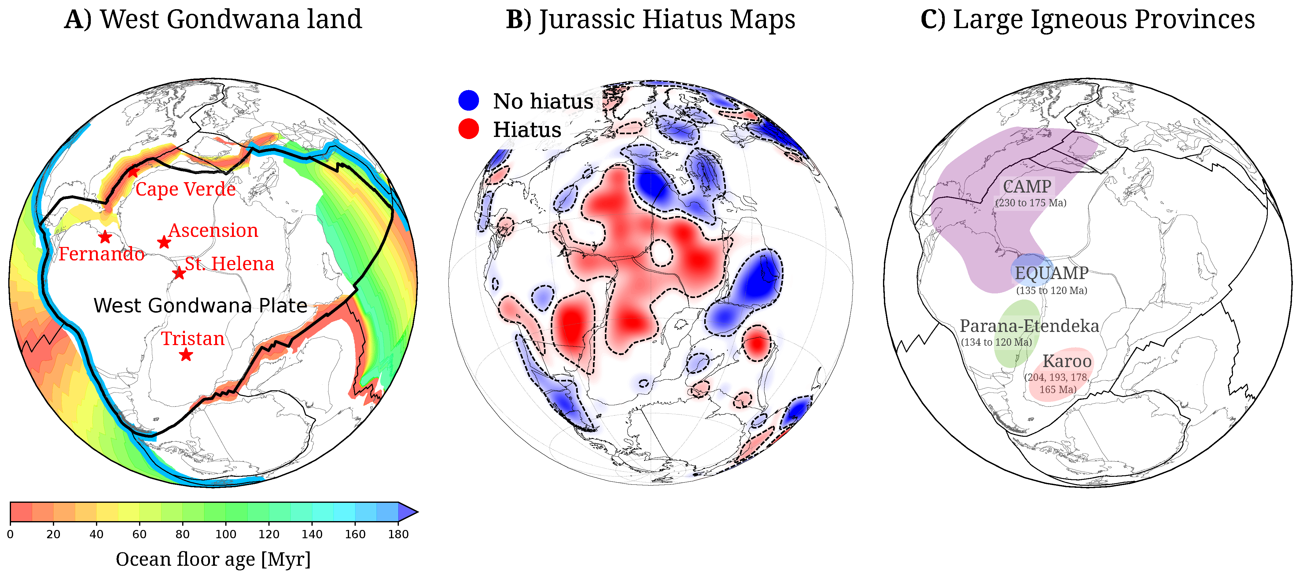
2. Plume Signal in the Stratigraphic Record

Plumes produce a dynamic uplift signal on the Earth’s lithosphere. This is seen in the stratigraphic record via hiatuses. In the pioneering work of Friedrich et al. [34], the authors developed a stratigraphic framework for analyzing continent-scale geological maps to map the surface expressions of plumes. The concept works as follows: as plumes rise from the core–mantle boundary toward the surface, they generate dynamic uplift of the surface. This, in turn, generates no deposition or erosion and leaves a gap in the sedimentary record. If the plume is deep in the mantle, its upwelling signal will be of low amplitude and large areal extent. However, closer to the surface, the uplift signal increases in amplitude but decreases in areal extent. Colli et al. [41] provide a detailed quantitative framework for this process through the use of geodynamic uplift kernels. This sequence of events leaves a characteristic sedimentary signature that can be mapped on continental regions, as described by Friedrich et al. [34] and Friedrich [42]. Recent examples of continent-scale mapping for Europe and Africa are given in [43] and Carena et al. [44]. The stratigraphic record in the continents of South America and Africa describes the path and timing of plume events.
Our analysis draws on a newly compiled inventory of hiatus surfaces documented in a series of studies by Hayek et al. [40], Vilacís et al. [15], and Vilacís et al. [45]. Their mapping efforts covered unconformable and conformable contacts globally at the time level of geological series [46]. The hiatus surfaces are modeled using spherical harmonics based on scattered contacts classified as no-hiatus or hiatus and are subsequently convolved with a Gaussian filter with a cutoff at degree 15. They serve as a proxy to map the uplift periods of the lithosphere. Figure 1B shows the hiatus surfaces for the West Gondwana continent in the late Jurassic. Red and blue indicate high and low topography on the series in question. Blank regions indicate the absence of the series in question and its immediately preceding unit. We interpret these regions as having undergone long-lasting erosion or non-deposition. This indicates intense and/or prolonged exhumation and uplift.
Figure 1B shows the wide distribution of hiatus surfaces for the late Jurassic. Much of the African continent has hiatus surfaces. Half of the South American continent shows blank regions, reflecting the absence of Jurassic to late-Cretaceous series. There is a clear correlation between the plume locations in Figure 1A and the spatial distribution of hiatus surfaces across South America and Africa in Figure 1B. In particular, the hiatus surface extends all along the coast that connects these two continents. This wide distribution of hiatus surfaces in the late Jurassic indicates that plume pulses occurred during the early Cretaceous, accompanied by widespread volcanic activity.

3. Large Igneous Provinces at the Time of Rifting

Plume-driven eruptions produce vast, voluminous regions of mafic igneous extrusive and intrusive rocks on the Earth’s surface, now recognized as large igneous provinces (LIPs) e.g., [37,47,48,49]. Unlike mid-ocean ridge volcanism, LIPs are not associated with seafloor spreading. In addition, these provinces are fundamentally different from any currently active volcanic systems or individual volcanoes. LIPs are fed by a vast and often complicated plumbing system that can include dyke swarms and sill complexes, as well as mid- to upper-crustal intrusive complexes. These swarms are often radiating in pattern—extending outward for more than 2500 km from a central plume center—and are commonly associated with domal uplift during the early stages of plume emplacement [50]. Dyke swarms also exhibit a circumferential pattern, ranging from 450 to 2500 km in diameter, and are mostly associated with giant radiating dyke swarms (for details, see Buchan and Ernst [51]). The coexistence of both radiating and circumferential geometries in some provinces can be exploited to link stress and magmatic processes associated with plume–lithosphere interaction e.g., [52,53]. We analyze in detail the dispersal of West Gondwana in the context of LIPs and dyke swarms to test the prediction of a causal relationship between the proposed plumes and continental rifting.
The opening of the South Atlantic Ocean may have followed the Pan-African sutures and started in the early Cretaceous (∼134–126 Ma) e.g., [54,55]. The opening followed the emplacement of vast amounts of mafic igneous extrusive and intrusive rocks associated with the central Atlantic magmatic province (CAMP) in the late Triassic to Jurassic e.g., [56,57]. This triggered the formation of multiple dyke swarms across northern South America and northwestern Africa e.g., [58,59]. Similarly, the Karoo igneous province consists of Jurassic basaltic rocks preserved in southern Africa e.g., [60], and its counterpart, the Ferrar province, extends from Antarctica to Australia and New Zealand e.g., [61]. Southern Africa has several dykes dating to this period of time e.g., [58,62]. These two vast magmatic events left the northern and southern portions of Africa and South America filled with intrusive dykes. The early Cretaceous Paraná–Etendeka flood basalts suggest that the primary magmatic phase occurred between approximately ∼138 and ∼121 Ma [63,64], with subsequent volcanic activity recorded up to 90 and 83 Ma [61]. This event was nearly simultaneous with the emplacement of the equatorial magmatic province (EQUAMP). Its main phase of eruptions occurred between ∼138 Ma and ∼81 Ma, with some younger periods of eruptions dated at ∼75–70 Ma and ∼68–49 Ma [61,65]. The extent and long duration of these large igneous provinces are related to the plume activity in the region (Figure 1A). The timing of these events suggests that more than one plume was active at that time. The preserved structures (dykes) in the lithosphere during the earlier periods of LIP emplacement play an important role in the overall strength of the lithosphere (for a recent review, see [66]). Large igneous provinces allow one to further constrain the extent and timing of mantle plume events in relation to continental rifting [47,49].

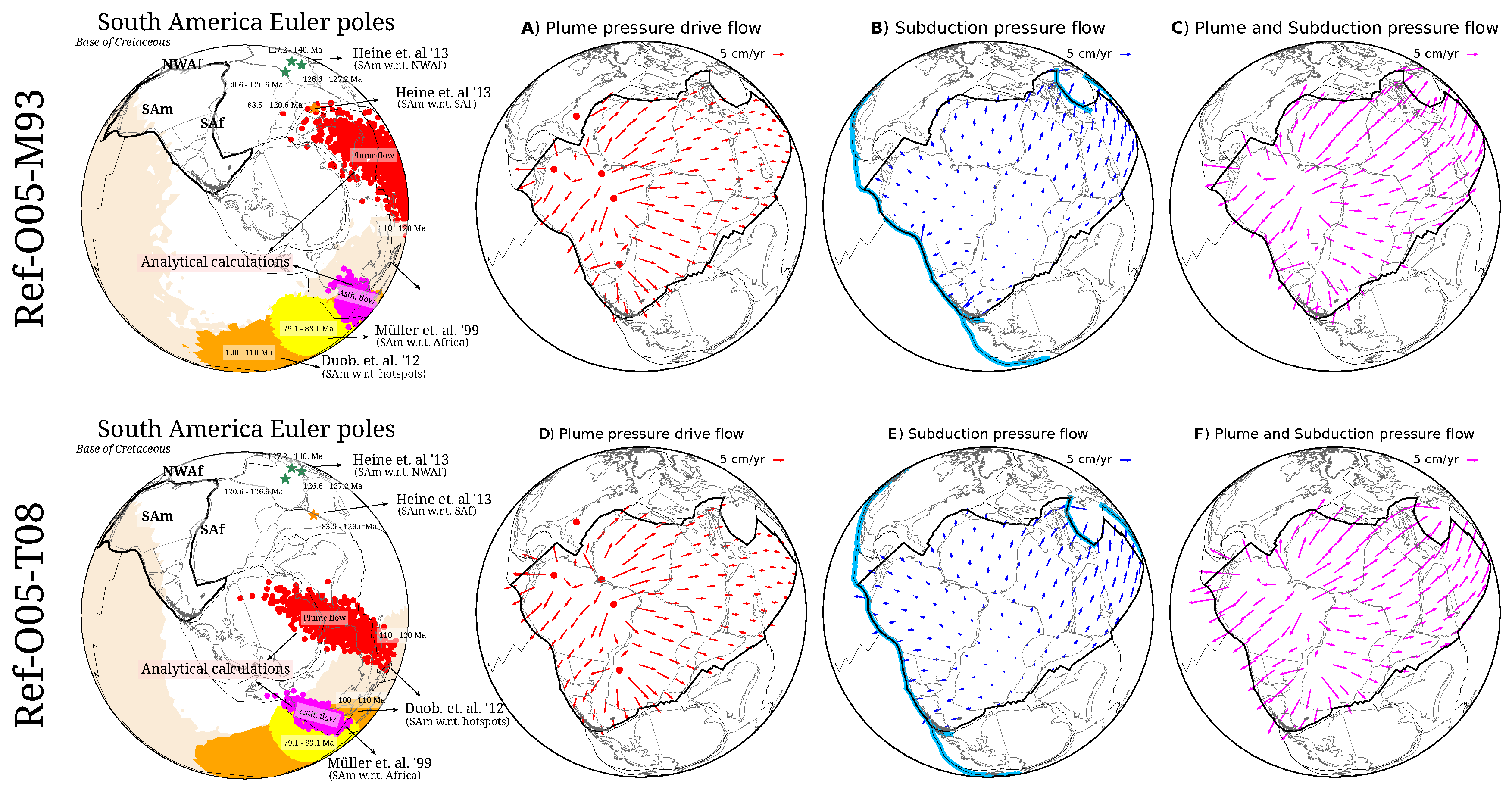
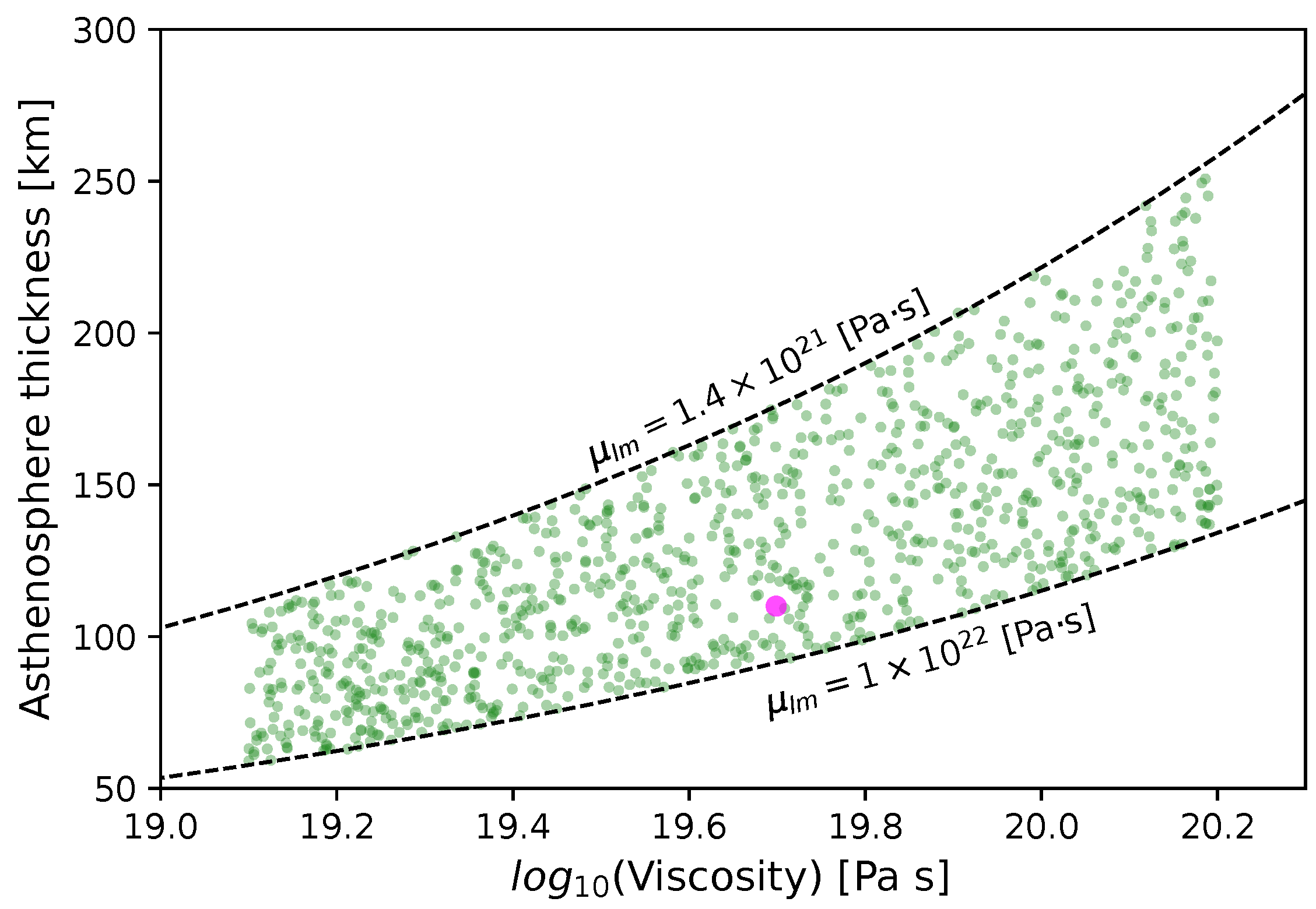
4. Poiseuille Flow Model

The interaction between asthenosphere flow and tectonic plates has been the focus of numerous studies [67,68,69], with the velocity of the underlying flow often treated as a free parameter. This choice is motivated by the fact that tectonic plates obscure the asthenosphere flow beneath them, allowing it to be integrated over a wide area and making it non-unique. Thus, here we make a prediction of asthenosphere flow beneath the West Gondwana plate based on the Poiseuille flow model. The asthenosphere is assumed to be of uniform thickness with a constant viscosity beneath non-deforming plates.
Evidence for the composition and structure of the asthenosphere comes from a variety of scientific disciplines. Viscosity is typically estimated from rheological experiments on rock samples [70], while the thickness of the asthenosphere can be inferred from upper-mantle seismic tomography and anisotropy studies (e.g., [22,71,72,73])—inferred to reach about 250 km depth. The asthenosphere thickness and its viscosity are related by inferences from post-glacial rebound [74] via a relationship that scales with ν D 3 , where ν is the viscosity contrast between the asthenosphere and the lowermost upper mantle and D is its thickness. Figure 2 shows the trade-off between the viscosity and thickness of the asthenosphere for two end-member values of the lowest upper-mantle viscosity, i.e., 1.4 · 10 21 and 1 · 10 22 Pa·s, down to a depth of 1400 km. These values come from the so-called Haskell constraint [75,76]. Postseismic deformation studies from continental regions at subduction zones have found asthenosphere viscosities ranging from 5 · 10 18 to 5 · 10 19 Pa·s [77,78,79]. In addition, geodynamic studies of the Pacific plate motion during the time of the Hawaiian–Emperor bend, along with glacial rebound models, suggest that the asthenosphere viscosity ranges from 4 · 10 19 to 5 · 10 20 Pa·s [80]. Mineralogical studies have constrained the depth of the asthenosphere beneath oceanic regions to between 100 and 400 km, based on phase equilibrium and physical properties [81,82]. This motivates the chosen ranges for the asthenosphere viscosity and thickness shown in Figure 2.
The Poiseuille flow beneath the West Gondwana plate is estimated for 10 3 possible combinations of asthenosphere viscosity and thickness. A specific combination—a thickness of 110 km and a viscosity of 5 · 10 19 Pa·s—is highlighted with a magenta dot in Figure 2, as it is consistent with previous numerical (e.g., [14]) and analytical (e.g., [19]) models. This combination is used to illustrate the extent and magnitude of Poiseuille flow beneath tectonic plates. The Poiseuille flow is calculated at the plume and slab locations shown in Figure 1.
The general equation for estimating the Poiseuille flow from plumes is given by
V p l u m e s = j D 2 8 μ Δ p j Δ x
where j represents the number of plumes considered, D is the asthenosphere thickness, μ its viscosity, and Δ x is the distance from the plume center. The expression Δ p j Δ x represents the pressure gradient, which is estimated from the density contrast, gravity, and topographic height in the following relationship: Δ p j = ρ g h j . Plumes are given strength based on a density contrast of 3300 kg/m3 and a topographic height varying between 100 m and 1400 m. In Figure 3A, a height of 1400 m is assumed and taken to be equal across plumes. This assumption is in good agreement with observational and theoretical estimates of the dynamic topography (e.g., [29,41,83]). The plume Poiseuille flow beneath the West Gondwana plate spreads radially from each plume center, decreasing in intensity with distance. It occurs within an asthenospheric channel characterized by zero velocity at its upper and lower boundaries. The flow velocity is maximum near the location of the plumes, particularly where multiple plumes converge. The plume flow has regional components and is still characterized by a long wavelength (Figure 3A). The flow also shows divergence at the common coastline of the South American and African continents.
The Poiseuille flow generated by slabs can be described by the following equation:
V s l a b s = i D 2 8 μ Δ p i Δ x
where i represents the number of discretized points along the geometry of the slab, assuming a density contrast of 2300 kg/m3 and a topographic subsidence of 200 m. The locations of the subducting margins are shown in Figure 1A. The slab Poiseuille flow is maximum near the subduction zone and decreases in intensity with distance. In particular, the minimum slab-flow velocity beneath West Gondwana is near the ridges close to Antarctica and India (Figure 3B). The slab Poiseuille flow is characterized by a smooth and long-wavelength pattern. It is also characterized by divergence near the southern ridge close to Antarctica and Madagascar.
By combining these two flow regimes (plumes and slabs), the total Poiseuille flow in the asthenosphere is constructed and shown in Figure 3C. This is by construction (i.e., V p o i s e u i l l e = V p l u m e s + V s l a b s ). The superposition of these two flow regimes can generate asthenosphere flow velocities up to ∼20 cm/yr (for a thickness of 110 km and a viscosity of 5 · 10 19 Pa·s). The fastest asthenosphere flow velocities are near the plume centers and near the subduction zones. This fast flow is due to the combination of extensive subduction margins along the western and northeastern boundaries of the West Gondwana plate and the combined effect of the five plumes within the plate. In particular, the Poiseuille flow beneath the South American plate is predominantly westward, while beneath the African plate, the flow is predominantly northeastward. This flow has a nearly constant velocity throughout the area due to the combined action of the plumes and slabs. It is also characterized by divergence close to the coastlines that connect South America to the African continent.

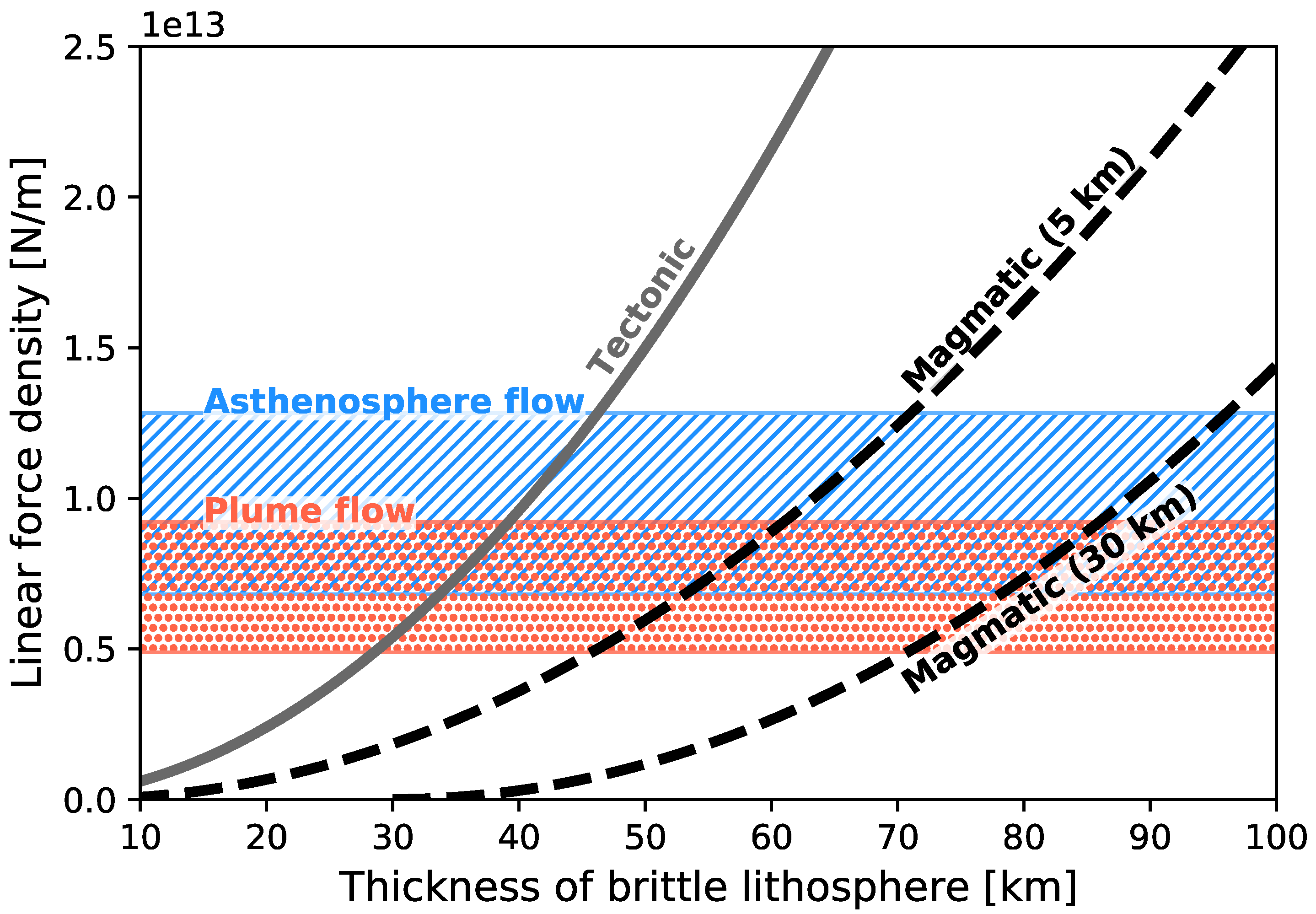
5. Continental Rift and Subsequent Drift

Here we test the hypothesis that the plume, slab, or combined flow is capable of generating sufficient force to rift the lithosphere of the West Gondwana plate. This can be compared to the strength required to rift a “healthy” lithosphere and one affected by dyke intrusions [66,84]. Once the plate has fully rifted apart, the motion of the South American and African plates is driven by the asthenosphere flow generated by plumes or in combination with slab flow (Poiseuille flow). This can also be checked against observations from plate kinematic reconstructions e.g., [85,86].
The minimum tectonic force required to rift the lithosphere is shown as a solid gray line in Figure 4. This force is calculated by integrating the stress required to allow normal fault slip on optimally oriented normal faults in an Andersonian stress field, where the vertical stress is the maximum principal stress and is lithostatic (i.e., [84]). For consistency, we rewrite the tectonic force equation defined by Buck [84] in the Appendix A. The strength of the lithosphere can be weakened by the intrusion of magmatic dykes. The magmatic force is defined by the strength required to open a dyke cutting through the lithosphere and is defined in the Appendix A. Here we define magmatic rifting to describe the lithospheric extensional force supported by dyke intrusion [66,84]. Dykes may not penetrate the entire lithosphere if the supply of magma is limited or if they are predominantly emplaced laterally from their plume center. Thus, the force needed to rift the lithosphere would be intermediate between that required for tectonic and magmatic rifting. Figure 4 plots these forces as a function of brittle lithosphere thickness for two examples of magmatic rifting, assuming crustal thicknesses of Hc = 5 km and Hc = 30 km.
We calculate a first-order linear force density that the Poiseuille flow will exert on the West Gondwana plate due to the arrival of all the plumes in the asthenosphere. To do this, we estimate the shear stresses at the base of the plate using the following relationship:
τ = i μ V f l o w , i D d A
where μ is the asthenosphere viscosity, V f l o w , i is the asthenosphere flow velocity below the West Gondwana plate, and D is half the asthenosphere channel thickness. Then, the magnitude of a linear force density is calculated by the following equation:
F b = τ L
which integrates the shear stress over the extent (L) of the West Gondwana plate (assumed to be 10,000 km). This gives a linear force density from the plumes alone of between 5 · 10 12 and 9 · 10 12 N/m. The variability in asthenospheric flow velocity magnitude is primarily driven by the combination of asthenosphere thickness and viscosity, with a secondary contribution from the relative strength of the plumes. A thick and highly viscous one will produce slow flow velocities, so the linear force density will be low. The opposite case, a thin and low-viscous one, will produce fast flow velocities, increasing the linear force density accordingly.
The results suggest that the plume flow alone should be able to rift a ∼35 km thick lithosphere, and if this has been weakened by the intrusion of dykes, it should be able to rift up to an ∼85 km thick lithosphere. These results represent two end members. This is shown in Figure 4, with a plume flow highlighted in the dashed orange area. When the crustal thickness is thinner (5 km instead of 30 km), the magmatic force increases.
The combined Poiseuille flow from plumes and slabs provides a higher linear force density of up to 1.3 · 10 13 N/m. This force could be capable of rifting a ∼45 km thick lithosphere. In addition, if the lithosphere were intruded by dykes, the asthenosphere flow would be capable of rifting a ∼95 km thick lithosphere (Figure 4). The Poiseuille flow in the asthenosphere is capable of rifting the West Gondwana plate into the South American and African plates.
The motion of South America and Africa can be reconstructed using the datasets from Müller et al. [85] (1999) and Doubrovine et al. [86] (2012), which are publicly available. The former dataset describes the motion of South America as it moves away from Africa, while the latter describes the absolute motion of the South American plate. We make the further assumption that Africa has remained stable over the Cretaceous time and estimate the motion of South America with respect to Africa based on the reconstruction from Müller et al. [85]. We are not interested in the magnitude of motion but rather in the direction of drifting. This can be expressed in terms of Euler poles. The advantage is that its compact format enables the assessment of various datasets at the same time. Although the opening may have begun early, the oldest isochrons on the South Atlantic seafloor are between ∼79 and ∼83 Ma [85]. This is consistent with a geomagnetic normal-polarity superchron e.g., [87]. The reconstructed rifting direction (Euler pole) between South America and Africa is located off the east coast of Australia. This Euler pole describes a westward drift of South America and is represented by the yellow area in Figure 5. This area represents the uncertainty in the reconstruction, as described by the covariance matrix. The global plate reconstructions from Doubrovine et al. [86] are based on an optimization procedure using a moving-hotspot reference frame and relative plate motions. The motion of South America in this reconstruction model starts at 120 Ma. The oldest stage (110–120 Ma) and its uncertainty are shown in light gray in Figure 5, while the following stage (100–110 Ma) and its uncertainty are shown in orange. Interestingly, the younger (100–110 Ma) of the two stages is well within the uncertainty of the older stage (110–120 Ma). Overall, the reconstructions from Müller et al. [85] and Doubrovine et al. [86] agree on a general westward motion of South America relative to Africa or an absolute reference frame. This also implies that the assumption that Africa was stable during the Cretaceous is a good approximation.
Early rifting stages (120 to 140 Ma) in the South Atlantic were compiled by Heine et al. [55] based on an inventory of continental rifts from the conjugate margins of South America and Africa. The Euler pole location of the motion of South America relative to South and Northwest Africa is near the Arabian Peninsula (Figure 5) and describes a southwestward motion.
We estimate the direction of drift of South America away from Africa, driven by the force generated by the Poiseuille flow. This allows us to estimate geometrically, without having to make further assumptions about the magnitude of the velocity, whether the flow from plumes or in combination with slabs is capable of drifting South America, as observed from the reconstructions mentioned above. This is done by simply integrating the flow velocity from Figure 3 over the area of the South American plate. The average over its area will give the direction of South America. This is done over the various combinations of asthenosphere thickness/viscosity and plume strength. Note that the relative plume strength is the dominant controlling factor in the direction of motion due to its dependence on geometry, whereas thickness and viscosity primarily influence its magnitude. The direction of motion of South America from the plume flow alone is shown in Figure 5 with red dots. A small number of combinations drive South America in agreement with the older stages from Doubrovine et al. [86] (i.e., 110–120 Ma). In other words, the South American plate can be driven westward by plumes alone. The fit to the observations improves when the slab flow is included. The combined asthenosphere flow from plumes and slabs predicts a motion of the South American plate that fits well with the kinematic reconstructions from Doubrovine et al. [86] (100–110 Ma) and Müller et al. [85] (79.1–83.3 Ma). This is shown in Figure 5, where the direction of motion represented by the magenta dots falls well within both reconstructions.

6. Discussion

There is a long history of linking continental rifting, large igneous provinces (LIPs) emplacements, and mantle convection and plume events e.g., [37,58,61,66,88,89,90,91,92]. Much of the flow in the asthenosphere comes from the plume mode of convection (e.g., [12,93]). The channelized nature of the asthenosphere allows it to be modeled analytically within the framework of the Poiseuille flow regime (e.g., [14,16,17,18,19,20,21]). A key advantage of such fundamental models is their ability to provide clear predictions of flow behavior, identifying regions where model results agree with surface observations and where discrepancies arise. Poiseuille flow in the asthenosphere, driven by mantle plumes, provides the link between the surface observations of continental rifting and the plume mode of mantle convection.
Our results demonstrate quantitatively that mantle plumes are the primary driver of continental rifting through rapid Poiseuille flow. Divergent motions of the lithosphere will lead to its rifting. Plumes generate regional divergent flow, and the combined action of multiple plumes generates large-scale divergent flow. Figure 3A shows the divergent plume flow along the continental coastal margin of South America and Africa, with the highest flow velocity near the center of divergence. The slab flow generates a coherent, smooth, and large-scale flow that is difficult to link to rifting (Figure 3B), with the highest flow velocity far away from any possible divergence. The combined Poiseuille flow (plumes and slabs) generates an even stronger divergence along the conjugate coast of South America and Africa (Figure 3C).
Plume activity and its temporal evolution are well constrained in the observational record. Plumes generate dynamic topography that leaves a distinct signal in the surface stratigraphy e.g., [34]. The sedimentary record, one of the most fundamental geological observations, has been studied for centuries. However, linking them to mantle convection beneath the lithosphere has required significant theoretical advances e.g., [29,41]. Beneath the West Gondwana continent, rising plumes induce lithospheric uplift (Figure 6A), a process that is supported by stratigraphic records in South America and Africa (Figure 1B). In addition, these records provide insight into the number of ascending plumes and their time of arrival in the asthenosphere. Once plumes reach the asthenosphere, they generate large amounts of igneous rock eruptions in the lithosphere at the surface. The distinct provinces of major eruptions across West Gondwana serve as a proxy for the intensity and extent of plume activity during the late Cretaceous (see Figure 1C). Plume pulses are recorded by the distribution of dykes in South America and Africa e.g., [59,60,94]. Dyke intrusions in the lithosphere also have the capacity to reduce the overall strength of the lithosphere e.g., [84]. This means that the presence of dyke intrusion reduces the necessary linear force density required to open the lithosphere via extensional forces from the divergent plume flow (see Figure 4). The maximum linear force density estimated here is 1.3 · 10 13 N/m, which allows rifting a “healthy” lithosphere of up to 45 km thick, but up to 90 km if it has been intruded by dykes. Buck [84] estimated that the gravitational potential force that plumes would generate from the dynamic uplift of the lithosphere is 5 · 10 12 N/m. This means that the combined contribution of these two forces (gravity and flow) could rift a lithosphere more than 100 km thick (see Figure 4). The channelized nature of the asthenosphere allows the development of fast plume flow and strong divergent currents below tectonic plates (Figure 6C). Plume Poiseuille flow is the most straightforward mechanism for rifting the lithosphere.
Temporal variations in the dynamic topography (non-isostatic vertical motions) of the lithosphere are often followed by changes in plate motion, as reported in several studies, including Colli et al. [22], Vibe et al. [43], and Vilacís et al. [15]. This aligns with the idea that plumes can generate substantial dynamic topography and sufficient basal shear stresses to drive changes in plate motion through a plume-push torque e.g., [95]. In fact, recent work has demonstrated that the Kerguelen plume is a dynamically viable mechanism for driving the separation of Australia from Antarctica [20]. Thus, the link between plume-induced vertical plate motions and changes in horizontal plate motions—which can be further linked to continental rifting—is made explicit. The magnitude of the linear force density is directly proportional to the magnitude of the flow velocity, which depends on the choice of the viscosity and thickness of the asthenospheric channel. We are less concerned with the magnitude of the flow because it is not well constrained. There are only indirect observations of the asthenosphere flow velocity. The best estimate was made by Hartley et al. [96], who estimated that the plume flow of the Icelandic plume at the time of high activity yielded a velocity of 35 cm/yr. This is for a single plume. Our flow calculations predict almost half (∼20 cm/yr) of this value for a combination of five plumes. Thus, we are probably at the lower end of the spectrum of asthenosphere flow velocities. The direction of motion of the South American plate is well constrained because it depends on the geometry of the plates involved and their boundaries. Note that the direction of plate motion can be predicted independently of the flow magnitude. Our results hold regardless of the choice of absolute reference frame. The effect of a different reference frame on our calculations is to place the plumes in different locations relative to South America and Africa. For example, in Figure A1 in the Appendix B, the plumes are located more within the South American continent, in contrast to Figure 3. Figure A1 in the Appendix B also shows that the plume flow predicts a South American motion that is closer to the reconstructions from Heine et al. [55] for the earlier stages of rifting between the South American and African continental blocks. The analytical flow models presented here quantitatively link plume activity, LIPs, the dynamic uplift of the lithosphere, and the evolution of continental rifting (summarized in Figure 6). Our results show that the lithosphere can be rifted by the underlying asthenosphere flow when lithospheric strength is modified by dyke intrusions.
The analytical flow model has some limitations. For example, choosing a constant channel thickness might overlook the dynamic impact of continental thickness [97,98]. We highlight the influence of lithospheric thickness and address it indirectly by estimating the linear force density required to rift the lithosphere for different thicknesses (Figure 4). However, the motion of the South American plate appears to be independent of the lithospheric thickness and depends mostly on the geometry of the plate relative to the location of the plumes. So we argue that the thickness of the lithosphere plays a role in determining whether plates can rift at all; otherwise, the lithosphere would rift everywhere at all times and not allow the development of large plates. This is not the case on Earth because we have several large plates. This study does not take into account the gravitational potential energy associated with the domal uplift from the plume. Incorporating it in future analyses would strengthen the inferences regarding plume-driving forces. Furthermore, we assume a Newtonian rheology, even though there is strong evidence for a non-Newtonian rheology in the upper mantle [99], which could produce a more complex pattern of asthenosphere flow [100].
Previous studies have highlighted a spatial correlation between continental rifting and preexisting orogenic belts, often associated with the Wilson cycle [101,102]. Orogenic belts develop crustal weaknesses due to faulting that can be reactivated during periods of extension e.g., [101,103,104,105,106]. However, the path of the Yellowstone hotspot track across western North America challenges this assumption e.g., [19]. If preexisting orogenic weakness alone dictated rifting, the North American plate should be actively rifting—but it is not. This suggests that successful continental rifting requires additional factors, i.e., dyke intrusions. In other words, the combined effects of (i) a faulted orogenic belt and (ii) the preexistence of dykes could significantly weaken the lithosphere. There are other geological processes that can also weaken the lithosphere (for an overview, see [66]). This facilitates rifting of the lithosphere. In addition, our results suggest that a single plume event may not be sufficient to initiate rifting; instead, a sequence of plume-driven events at a given location is required to sufficiently weaken the lithosphere.
Recall from the introduction that early ideas about plate tectonics came from observations of the geometry of continents that were once together e.g., [107]. Based on our results, we further argue that the global geometric distribution of hotspots could match the coastlines of continents prior to their rifting. Figure A1 in the Appendix B shows that our results remain the same if one uses an alternative reference frame and reconstruction. This will reshape the asthenosphere flow because the location of plumes relative to the plates will vary, thereby influencing how those currents drive the motion of South America. Notably, the reconstructions from Müller et al. [85] and Doubrovine et al. [86] both indicate a consistent direction of South America’s motion relative to Africa and hotspots, respectively. This agreement—illustrated in Figure 5 by the alignment of Euler pole locations—suggests that the African plate remained relatively stable during the Cretaceous. Our results may therefore help guide and motivate the development of alternative absolute reference frames for plate reconstructions.

7. Conclusions

This study presents a straightforward mechanism that explains continental rifting and plate motions during this time. Our analytical calculations provide a prediction of past asthenosphere flow and its associated torque, which drove the Poiseuille flow-induced rifting of South America from Africa. In this model, Poiseuille flow in the asthenosphere arises from pressure gradients generated by mantle plumes along the common South America–Africa margin and by subduction zones surrounding the West Gondwana plate. Notably, Poiseuille flow driven by subducting slabs tends to remain relatively steady over time, except when new subduction zones form. In contrast, plume-driven Poiseuille flow can be episodic, generating transient asthenospheric flows and associated torques that influence plate motion. This has been demonstrated in previous studies that have shown that the Kerguelen Plume caused Australia and Antarctica to separate during the Eocene.
The strength of the Poiseuille flow model is its ability to quantitatively link the underlying mantle flow to surface observations. Our results successfully explain the early Cretaceous rifting of the West Gondwana plate, including the dynamic uplift of West Gondwana during the Jurassic (prior to rifting), the emplacement of large igneous provinces at the onset of rifting, and the subsequent separation and movement of the newly formed continents, South America and Africa. In addition, our findings align well with previous studies suggesting that rifting tends to occur along sutures of ancient orogenic belts. We demonstrated that mantle plume upwellings, rather than subduction, are the dominant control on continental rifting and plate tectonics. The analytical approach presented here allows for a quantitative reconstruction of past mantle flow.

Author Contributions

Conceptualization, I.L.S.; methodology, I.L.S. and B.V.; software, I.L.S., J.N.H. and B.V.; validation, I.L.S., J.N.H. and B.V.; formal analysis, I.L.S. and H.-P.B.; investigation, I.L.S. and H.-P.B.; resources, I.L.S.; data curation, I.L.S., J.N.H. and B.V.; writing—original draft preparation, I.L.S.; writing—review and editing, I.L.S., J.N.H., B.V. and H.-P.B.; visualization, I.L.S. and B.V.; project administration, I.L.S.; funding acquisition, I.L.S. All authors have read and agreed to the published version of the manuscript.

Funding

I.L.S. received funding from the Deutsche Forschungsgemeinschaft (grant STO1271/2-1).

Institutional Review Board Statement

Not applicable.

Informed Consent Statement

Not applicable.

Data Availability Statement

The finite rotation dataset can be found in Müller et al. [85], Doubrovine et al. [86], Heine et al. [55]. The LIPS location dataset can be found in the reference list. The inventory of the Base Hiatus Surface dataset can be found in Hayek et al. [40].

Acknowledgments

I.L.S. acknowledges support from the Deutsche Forschungsgemeinschaft (DFG) under project number STO1271/2-1. We would like to thank the four anonymous reviewers and editors Richard E. Ernst and Hafida El Bilali for their valuable contributions in improving the manuscript.

Conflicts of Interest

The authors declare there are no conflicts of interest.

Appendix A

For completeness, we include here the equations from Buck [84]. The force required for tectonic rifting is calculated using the following equation:
F T = C H L 2 2
where C is 1.2 · 10 4 Pa m−1 and H L is the thickness of the brittle lithosphere. Magmatic force is defined by the strength required to open a dyke that cuts through the lithosphere and is described by the following equation:
F M = g ( ρ m ρ f ) ( H L H c ) 2 2
where g is the gravity, the density of the mantle is ρ m = 3300 kg m−1, the density of the fluid magma is ρ f = 2700 kg m−1, and H c is the thickness of the crust.

Appendix B

The choice of an absolute reference frame to plate the locations of plumes relative to the South American and African continents does not change our results. In fact, it provides new insights into the relative motion of plumes and continents, as well as their role in rifting the lithosphere. The reference frame choices are shown in Figure A1. The reference frame labeled Ref-O05-T08 uses an Indo-Atlantic moving-hotspot reference frame from O’Neill et al. [108] for the past 100 Myrs and a True Polar Wander-corrected paleomagnetic model from Steinberger and Torsvik [109] for older times. The reference frame labeled Ref-O05-M93 applies a reference frame of Indo-Atlantic moving hotspots from O’Neill et al. [108] for the last 100 Myrs and of fixed African hotspots from Müller et al. [110] for older times.
Figure A1. Movement of the South American plate in the early Cretaceous, shown for different reference frames, relative to the location of plumes and West Gondwana. The reconstructed Euler pole of the South American plate with respect to the African plate by Müller et al. [85] is shown in yellow, and the absolute motion of the South American plate by Doubrovine et al. [86] is shown in light gray and light brown. Both reconstructions include their respective uncertainties. Reconstructions of the early stages of South Atlantic rifting by Heine et al. [55] are shown with green and yellow stars (no uncertainties provided). Red dots indicate the predicted motion of South America driven by plume-generated flow. Magenta dots show the predicted motion of South America driven by flow generated by asthenosphere processes (plumes and slabs). These results show that Poiseuille flow from plumes and slabs is capable of driving South America westward, away from Africa. Example of asthenosphere flow driven by Poiseuille flow from plumes and slabs in the early Cretaceous: (A,D) Flow generated by plumes within the asthenosphere, spreading radially outward from the source. (B,E) Asthenosphere flow induced by subducting slabs, with flow directed toward the slab. (C,F) Superposition of flow generated by both a plume and a subducting slab.
Minerals 15 00644 g0a1

References

  1. Wegener, A. Die Entstehung der Kontinente und Ozeane, 5th ed.; Friedr. Vieweg & Sohn A.-G.: Braunschweig, Germany, 1929. [Google Scholar]
  2. Carey, S.W. Wegener’s South African Assembly, Fit or Misfit? Geol. Mag. 1955, 92, 196–200. [Google Scholar] [CrossRef]
  3. Bullard, E.; Everett, J.; Smith, A. The fit of the continents around the Atlantic. Philos. Trans. R. Soc. Lond. 1965, 258, 41–51. [Google Scholar] [CrossRef] [PubMed]
  4. Sykes, L.R. Seismicity of the South Pacific Ocean. Geophys. Res. 1963, 68, 5999–6006. [Google Scholar] [CrossRef]
  5. Sykes, L.R. The seismicity of the Arctic. Bull. Seismol. Soc. Am. 1965, 55, 501–518. [Google Scholar]
  6. Cox, A.; Doell, R.R.; Dalrymple, G.B. Geomagnetic polarity epochs and Pleistocene geochronometry. Nature 1963, 198, 1049–1051. [Google Scholar] [CrossRef]
  7. Cox, A. Geomagnetic reversals. Science 1969, 163, 237–245. [Google Scholar] [CrossRef]
  8. McDougall, I.; Tarling, D.H. Dating of polarity zones in the Hawaiian islands. Nature 1963, 200, 54–56. [Google Scholar] [CrossRef]
  9. Maxwell, A.E.; Von Herzen, R.P.; Hsu, K.J.; Andrews, J.E.; Saito, T.; Percival, S.F.; Milow, E.D.; Boyce, R.E. Deep sea drilling in the South Atlantic. Science 1970, 168, 1047–1059. [Google Scholar] [CrossRef] [PubMed]
  10. Ewing, M.; Ewing, J.; Talwan, M. Sediment distribution in the oceans: The Mid-Atlantic Ridge. Bull. Seismol. Soc. Am. 1964, 75, 17–36. [Google Scholar] [CrossRef]
  11. Wilson, J.T. A new class of faults and their bearing on continental drift. Nature 1965, 207, 343–347. [Google Scholar] [CrossRef]
  12. Davies, G.F.; Richards, M.A. Mantle convection. J. Geol. 1992, 100, 151–206. [Google Scholar] [CrossRef]
  13. Richards, M.A.; Lenardic, A. The Cathles Parameter (Ct): A Geodynamic Definition of the Asthenosphere and Implications for the Nature of Plate Tectonics. Geochem. Geophys. Geosyst. 2018, 19, 4858–4875. [Google Scholar] [CrossRef]
  14. Stotz, I.L.; Iaffaldano, G.; Davies, D.R. Pressure-Driven Poiseuille Flow: A Major Component of the Torque-Balance Governing Pacific Plate Motion. Geophys. Res. Lett. 2018, 45, 117–125. [Google Scholar] [CrossRef]
  15. Vilacís, B.; Hayek, J.N.; Stotz, I.L.; Bunge, H.P.; Friedrich, A.M.; Carena, S.; Clark, S. Evidence for active upper mantle flow in the Atlantic and Indo-Australian realms since the Upper Jurassic from hiatus maps and spreading rate changes. Proc. R. Soc. Math. Phys. Eng. Sci. 2022, 478, 20210764. [Google Scholar] [CrossRef]
  16. Hoeink, T.; Lenardic, A. Three-dimensional mantle convection simulations with a low-viscosity asthenosphere and the relationship between heat flow and the horizontal length scale of convection. Geophys. Res. Lett. 2008, 35. [Google Scholar] [CrossRef]
  17. Hoeink, T.; Lenardic, A. Long wavelength convection, Poiseuille-Couette flow in the low-viscosity asthenosphere and the strength of plate margins. Geophys. J. Int. 2010, 180, 23–33. [Google Scholar] [CrossRef]
  18. Hoeink, T.; Lenardic, A.; Richards, M. Depth-dependent viscosity and mantle stress amplification: Implications for the role of the asthenosphere in maintaining plate tectonics. Geophys. J. Int. 2012, 191, 30–41. [Google Scholar] [CrossRef]
  19. Stotz, I.L.; Vilacís, B.; Hayek, J.N.; Bunge, H.P.; Friedrich, A.M. Yellowstone Plume Drives Neogene North American Plate Motion Change. Geophys. Res. Lett. 2021, 48, e2021GL095079. [Google Scholar] [CrossRef]
  20. Stotz, I.L.; Carena, S.; Vilacís, B.; Hayek, J.N.; Bunge, H.P. Kerguelen Plume Drives the Eocene Directional Change in Australian Plate Motion. Lithosphere 2024, 2024, lithosphere_2023_289. [Google Scholar] [CrossRef]
  21. Wang, Z.R.; Stotz, I.L.; Bunge, H.P.; Vilacís, B.; Hayek, J.N.; Ghelichkhan, S.; Lebedev, S. Cenozoic upper mantle flow history of the Atlantic realm based on Couette/Poiseuille models: Towards paleo-mantle-flowgraphy. Phys. Earth Planet. Inter. 2023, 340, 107045. [Google Scholar] [CrossRef]
  22. Colli, L.; Stotz, I.; Bunge, H.P.; Smethurst, M.; Clark, S.; Iaffaldano, G.; Tassara, A.; Guillocheau, F.; Bianchi, M.C. Rapid South Atlantic spreading changes and coeval vertical motion in surrounding continents: Evidence for temporal changes of pressure-driven upper mantle flow. Tectonics 2014, 33, 1304–1321. [Google Scholar] [CrossRef]
  23. Conrad, C.P.; Lithgow-Bertelloni, C. How Mantle Slabs Drive Plate Tectonics. Science 2002, 298. [Google Scholar] [CrossRef]
  24. Morgan, W.J. Plate motions and deep mantle convection. Mem. Geol. Soc. Am. 1972, 132, 7–22. [Google Scholar]
  25. Morgan, W. Convection Plumes in the Lower Mantle. Nature 1971, 230, 42–43. [Google Scholar] [CrossRef]
  26. Morgan, J.P.; Smith, W.H.F. Flattening of the sea-floor depth-age curve as a response to asthenospheric flow. Nature 1992, 359, 524–527. [Google Scholar] [CrossRef]
  27. Morgan, J.P.; Morgan, W.J.; Zhang, Y.S.; Smith, W.H.F. Observational hints for a plume-fed, suboceanic asthenosphere and its role in mantle convection. J. Geophys. Res. Solid Earth 1995, 100, 12753–12767. [Google Scholar] [CrossRef]
  28. Stotz, I.L.; Vilacís, B.; Hayek, J.N.; Carena, S.; Bunge, H.P. Plume driven plate motion changes: New insights from the South Atlantic realm. J. South Am. Earth Sci. 2023, 124, 104257. [Google Scholar] [CrossRef]
  29. Hager, B.H.; Clayton, R.W.; Clayton, R.W.; Comer, R.P.; Dziewonski, A.M. Lower mantle heterogeneity, dynamic topography and the geoid. Nature 1985, 313, 541–545. [Google Scholar] [CrossRef]
  30. Şengör, A.M.C. Elevation as indicator of mantle-plume activity. Mantle Plumes Their Identif. Through Time 2001, 352, 183–245. [Google Scholar] [CrossRef]
  31. Rainbird, R.H.; Ernst, R.E. The sedimentary record of mantle-plume uplift. Spec. Pap.-Geol. Soc. Am. 2001, 352, 227–246. [Google Scholar] [CrossRef]
  32. Campbell, I.H. Testing the plume theory. Chem. Geol. 2007, 241, 153–176. [Google Scholar] [CrossRef]
  33. Saunders, A.; Jones, S.; Morgan, L.; Pierce, K.; Widdowson, M.; Xu, Y. Regional uplift associated with continental large igneous provinces: The roles of mantle plumes and the lithosphere. Chem. Geol. 2007, 241, 282–318. [Google Scholar] [CrossRef]
  34. Friedrich, A.M.; Bunge, H.P.; Rieger, S.M.; Colli, L.; Ghelichkhan, S.; Nerlich, R. Stratigraphic framework for the plume mode of mantle convection and the analysis of interregional unconformities on geological maps. Gondwana Res. 2018, 53, 159–188. [Google Scholar] [CrossRef]
  35. Suess, E. Das Antlitz der Erde (The Face of the Earth); G. Freytag: Leipzig, Germany, 1885; Volume 1. [Google Scholar]
  36. Lawver, L.A.; Gahagan, L.M. Subduction Zones, Magmatism, and the Breakup of Pangea. In Flow and Creep in the Solar System: Observations, Modeling and Theory; Springer: Amsterdam, The Netherlands, 1993; pp. 225–247. [Google Scholar] [CrossRef]
  37. Coffin, M.; Eldholm, O. Volcanism and continental break-up: A global compilation of large igneous provinces. Geol. Soc. Lond. Spec. Publ. 1992, 68, 17–30. [Google Scholar] [CrossRef]
  38. Burke, K.; Gunnell, Y. The African Erosion Surface: A Continental-Scale Synthesis of Geomorphology, Tectonics, and Environmental Change over the Past 180 Million Years. Geol. Soc. Am. Mem. 2008, 201, 21–66. [Google Scholar]
  39. Mueller, R.D.; Seton, M.; Zahirovic, S.; Williams, S.E.; Matthews, K.J.; Wright, N.M.; Shephard, G.E.; Maloney, K.T.; Barnett-Moore, N.; Hosseinpour, M.; et al. Ocean Basin Evolution and Global-Scale Plate Reorganization Events Since Pangea Breakup. Annu. Rev. Earth Planet. Sci. 2016, 44, 107–138. [Google Scholar] [CrossRef]
  40. Hayek, J.N.; Vilacís, B.; Bunge, H.P.; Friedrich, A.M.; Carena, S.; Vibe, Y. Continent-scale Hiatus Maps for the Atlantic Realm and Australia since the Upper Jurassic and links to mantle flow induced dynamic topography. Proc. R. Soc. Math. Phys. Eng. Sci. 2020, 476, 20200390. [Google Scholar] [CrossRef]
  41. Colli, L.; Ghelichkhan, S.; Bunge, H.P. On the ratio of dynamic topography and gravity anomalies in a dynamic Earth. Geophys. Res. Lett. 2016, 43, 2510–2516. [Google Scholar] [CrossRef]
  42. Friedrich, A.M. Palaeogeological hiatus surface mapping: A tool to visualize vertical motion of the continents. Geol. Mag. 2019, 156, 308–319. [Google Scholar] [CrossRef]
  43. Vibe, Y.; Friedrich, A.M.; Bunge, H.P.; Clark, S.R. Correlations of oceanic spreading rates and hiatus surface area in the North Atlantic realm. Lithosphere 2018, 10, 677–684. [Google Scholar] [CrossRef]
  44. Carena, S.; Bunge, H.P.; Friedrich, A.M. Analysis of geological hiatus surfaces across Africa in the Cenozoic and implications for the timescales of convectively-maintained topography. Can. J. Earth Sci. 2019, 56, 1333–1346. [Google Scholar] [CrossRef]
  45. Vilacís, B.; Brown, H.; Bunge, H.P.; Carena, S.; Hayek, J.N.; Stotz, I.L.; Wang, Z.R.; Friedrich, A.M. Dynamic topography and the planform of mantle convection since the Jurassic inferred from global continental hiatus maps. Proc. R. Soc. Math. Phys. Eng. Sci. 2024, 480, 20240311. [Google Scholar] [CrossRef]
  46. Cohen, K.M.; Harper, D.; Gibbard, P.L. ICS International Chronostratigraphic Chart. August 2018. Available online: www.stratigraphy.org (accessed on 10 February 2025).
  47. Ernst, R.E.; Buchan, K.L. Maximum size and distribution in time and space of mantle plumes: Evidence from large igneous provinces. J. Geodyn. 2002, 34, 309–342. [Google Scholar] [CrossRef]
  48. Coffin, M.F.; Eldholm, O. Large Igneous Provinces. In Encyclopedia of Ocean Sciences, 3rd ed.; Cochran, J.K., Bokuniewicz, H.J., Yager, P.L., Eds.; Academic Press: Oxford, UK, 2019; pp. 337–345. [Google Scholar] [CrossRef]
  49. Ernst, R.E.; Bond, D.P.G.; Zhang, S.H.; Buchan, K.L.; Grasby, S.E.; Youbi, N.; El Bilali, H.; Bekker, A.; Doucet, L.S. Large Igneous Province Record Through Time and Implications for Secular Environmental Changes and Geological Time-Scale Boundaries. In Large Igneous Provinces; American Geophysical Union (AGU): Washington, DC, USA, 2021; Chapter 1; pp. 1–26. [Google Scholar] [CrossRef]
  50. Buchan, K.L.; Ernst, R.E. Plumbing systems of large igneous provinces (LIPs) on Earth and Venus: Investigating the role of giant circumferential and radiating dyke swarms, coronae and novae, and mid-crustal intrusive complexes. Gondwana Res. 2021, 100, 25–43. [Google Scholar] [CrossRef]
  51. Buchan, K.; Ernst, R. Giant circumferential dykes swarms: Catalogue and characteristics. In Dyke Swarms of the World: A Modern Perspective; Srivastava, R., Ernst, R., Peng, P., Eds.; Springer: Singapore, 2019; pp. 1–44. [Google Scholar]
  52. El Bilali, H.; Ernst, R.E. Far-travelled 3700 km lateral magma propagation just below the surface of Venus. Nat. Commun. 2024, 15, 1759. [Google Scholar] [CrossRef] [PubMed]
  53. Tessier, A.D.; Ernst, R.E.; El Bilali, H. Heng-o Corona, Venus: Dyke swarms record evolution of its underlying mantle plume. Icarus 2024, 417, 116090. [Google Scholar] [CrossRef]
  54. Frimmel, H.E. Configuration of Pan-African Orogenic Belts in Southwestern Africa. In Neoproterozoic-Cambrian Tectonics, Global Change and Evolution: A Focus on Southwestern Gondwana; Gaucher, C., Sial, A., Haverson, G., Eds.; Elsevier: Amsterdam, The Netherlands, 2010; pp. 145–151. [Google Scholar]
  55. Heine, C.; Zoethout, J.; Müller, D. Kinematics of the South Atlantic Rift. Solid Earth 2013, 4, 215–253. [Google Scholar] [CrossRef]
  56. Baksi, A. Critical evaluation of 40Ar/39Ar ages for the Central Atlantic Magmatic Province: Timing, duration and possible migration of magmatic centers. In Washington DC American Geophysical Union Geophysical Monograph Series; Wiley: Hoboken, NJ, USA, 2003; Volume 136, pp. 77–90. [Google Scholar] [CrossRef]
  57. Whalen, L.; Gazel, E.; Vidito, C.; Puffer, J.; Bizimis, M.; Henika, W.; Caddick, M.J. Supercontinental inheritance and its influence on supercontinental breakup: The Central Atlantic Magmatic Province and the breakup of Pangea. Geochem. Geophys. Geosyst. 2015, 16, 3532–3554. [Google Scholar] [CrossRef]
  58. Ernst, R.E.; Buchan, K.L. Giant Radiating Dyke Swarms: Their Use in Identifying Pre-Mesozoic Large Igneous Provinces and Mantle Plumes. In Large Igneous Provinces: Continental, Oceanic, and Planetary Flood Volcanism; American Geophysical Union (AGU): Washington, DC, USA, 1997; pp. 297–333. [Google Scholar] [CrossRef]
  59. Marzoli, A.; Renne, P.R.; Piccirillo, E.M.; Ernesto, M.; Bellieni, G.; De Min, A. Extensive 200-million-year-old continental flood basalts of the central Atlantic magmatic province. Science 1999, 284, 616–618. [Google Scholar] [CrossRef]
  60. Cox, K.G. The Karoo Province. In Continental Flood Basalts; Macdougall, J.D., Ed.; Springer: Dordrecht, The Netherlands, 1988; pp. 239–271. [Google Scholar] [CrossRef]
  61. Segev, A. Flood basalts, continental breakup and the dispersal of Gondwana: Evidence for periodic migration of upwelling mantle flows (plumes). Egu Stephan Mueller Spec. Publ. Ser. 2002, 2, 171–191. [Google Scholar] [CrossRef]
  62. Burke, K.; Dewey, J.F. Plume-Generated Triple Junctions: Key Indicators in Applying Plate Tectonics to Old Rocks. J. Geol. 1973, 81, 406–433. [Google Scholar] [CrossRef]
  63. Piccirillo, E.M.; Melfi, A.J.; Comin-Chiaramonti, P.; Bellieni, G.; Ernesto, M.; Marques, L.S.; Nardy, A.J.R.; Pacca, I.G.; Roisenberg, A.; Stolfa, D. Continental Flood Volcanism From the Paraná Basin (Brazil). In Continental Flood Basalts; Macdougall,, J.D.,, Ed.; Springer: Dordrecht, The Netherlands, 1988; pp. 195–238. [Google Scholar] [CrossRef]
  64. Peate, D.W. The Paraná-Etendeka Province. In Large Igneous Provinces: Continental, Oceanic, and Planetary Flood Volcanism; American Geophysical Union (AGU): Washington, DC, USA, 1997; pp. 217–245. [Google Scholar] [CrossRef]
  65. Hollanda, M.H.B.M.; Archanjo, C.J.; Macedo Filho, A.A.; Fossen, H.; Ernst, R.E.; de Castro, D.L.; Melo, A.C.; Oliveira, A.L. The Mesozoic Equatorial Atlantic Magmatic Province (EQUAMP). In Dyke Swarms of the World: A Modern Perspective; Srivastava, R.K., Ernst, R.E., Peng, P., Eds.; Springer: Singapore, 2019; pp. 87–110. [Google Scholar] [CrossRef]
  66. Buck, R. 6.08 Dynamic Processes in Extensional and Compressional Settings: The Dynamics of Continental Breakup and Extension. Treatise Geophys. 2007, 6, 335–376. [Google Scholar] [CrossRef]
  67. Bird, P. Testing hypotheses on plate-driving mechanisms with global lithosphere models including topography, thermal structure, and faults. J. Geophys. Res.-Solid Earth 1998, 103, 10115–10129. [Google Scholar] [CrossRef]
  68. Brune, S. Forces within continental and oceanic rifts: Numerical modeling elucidates the impact of asthenospheric flow on surface stress. Geology 2018, 46, 191. [Google Scholar] [CrossRef]
  69. Bird, P.; Liu, Z.; Rucker, W.K. Stresses that drive the plates from below: Definitions, computational path, model optimization, and error analysis. J. Geophys. Res. 2008, 113, B11406. [Google Scholar] [CrossRef]
  70. Karato, S. On the origin of the asthenosphere. Earth Planet. Sci. Lett. 2012, 321–322, 95–103. [Google Scholar] [CrossRef]
  71. Grand, S.P.; Helmberger, D.V. Upper mantle shear structure of North America. Geophys. J. R. Astron. Soc. 1984, 76, 399–438. [Google Scholar] [CrossRef]
  72. Debayle, E.; Kennett, B.; Priestley, K. Global azimuthal seismic anisotropy and the unique plate-motion deformation of Australia. Nature 2005, 433, 509–512. [Google Scholar] [CrossRef]
  73. French, S.; Lekic, V.; Romanowicz, B. Waveform Tomography Reveals Channeled Flow at the Base of the Oceanic Asthenosphere. Science 2013, 342, 227–230. [Google Scholar] [CrossRef]
  74. Paulson, A.; Richards, M.A. On the resolution of radial viscosity structure in modelling long-wavelength postglacial rebound data. Geophys. J. Int. 2009, 179, 1516. [Google Scholar] [CrossRef]
  75. Haskell, N.A. The viscosity of the asthenoshpere. Am. J. Sci. 1937, 33, 22–28. [Google Scholar] [CrossRef]
  76. Mitrovica, J.X. Haskell [1935] revisited. J. Geophys. Res. Solid Earth 1996, 101, 555–569. [Google Scholar] [CrossRef]
  77. Freed, A.M.; Bürgmann, R.; Calais, E.; Freymueller, J.; Hreinsdóttir, S. Implications of deformation following the 2002 Denali, Alaska, earthquake for postseismic relaxation processes and lithospheric rheology. J. Geophys. Res. Solid Earth 2006, 111. [Google Scholar] [CrossRef]
  78. Freed, A.M.; Hashima, A.; Becker, T.W.; Okaya, D.A.; Sato, H.; Hatanaka, Y. Resolving depth-dependent subduction zone viscosity and afterslip from postseismic displacements following the 2011 Tohoku-oki, Japan earthquake. Earth Planet. Sci. Lett. 2017, 459, 279–290. [Google Scholar] [CrossRef]
  79. Hu, Y.; Bürgmann, R.; Banerjee, P.; Feng, L.; Hill, E.; Ito, T.; Tabei, T.; Wang, K. Asthenosphere rheology inferred from observations of the 2012 Indian Ocean earthquake. Nature 2016, 538, 368–372. [Google Scholar] [CrossRef]
  80. Iaffaldano, G.; Lambeck, K. Pacific plate–motion change at the time of the Hawaiian–Emperor bend constrains the viscosity of Earth’s asthenosphere. Geophys. Res. Lett. 2014. in review. [Google Scholar] [CrossRef]
  81. Stixrude, L.; Lithgow-Bertelloni, C. Mineralogy and elasticity of the oceanic upper mantle: Origin of the low-velocity zone. J. Geophys. Res. Solid Earth 2005, 110. [Google Scholar] [CrossRef]
  82. Patočka, V.; Čížková, H.; Pokorný, J. Dynamic Component of the Asthenosphere: Lateral Viscosity Variations Due to Dislocation Creep at the Base of Oceanic Plates. Geophys. Res. Lett. 2024, 51, e2024GL109116. [Google Scholar] [CrossRef]
  83. Hoggard, M.J.; Winterbourne, J.; Czarnota, K.; White, N. Oceanic residual depth measurements, the plate cooling model, and global dynamic topography. J. Geophys. Res. Solid Earth 2017, 122, 2328–2372. [Google Scholar] [CrossRef]
  84. Buck, W.R. The role of magma in the development of the Afro-Arabian Rift System. In The Afar Volcanic Province within the East African Rift System; Geological Society of London: London, UK, 2006. [Google Scholar] [CrossRef]
  85. Müller, R.D.; Royer, J.Y.; Cande, S.C.; Roest, W.R.; Maschenkov, S. Chapter 2: New constraints on the late cretaceous/tertiary plate tectonic evolution of the caribbean. In Caribbean Basins; Mann, P., Ed.; Elsevier: Amsterdam, The Netherlands, 1999; Volume 4, pp. 33–59. [Google Scholar] [CrossRef]
  86. Doubrovine, P.V.; Steinberger, B.; Torsvik, T.H. Absolute plate motions in a reference frame defined by moving hot spots in the Pacific, Atlantic, and Indian oceans. J. Geophys. Res. Solid Earth 2012, 117. [Google Scholar] [CrossRef]
  87. Algeo, T.J. Geomagnetic polarity bias pattern through the Phanerozoic. J. Geophys. Res. 1996, 101, 2785–2814. [Google Scholar] [CrossRef]
  88. Yuen, D.; Fleitout, L. Thinning of the lithosphere by small-scale convective destabilization. Nature 1985, 313, 125–128. [Google Scholar] [CrossRef]
  89. Fleitout, L.; Froidevaux, C.; Yuen, D. Active lithospheric thinning. Tectonophysics 1986, 132, 271–278. [Google Scholar] [CrossRef]
  90. Sleep, N. Lithospheric Heating by Mantle Plumes. Geophys. J. R. Astron. Soc. 1987, 91, 1–11. [Google Scholar] [CrossRef]
  91. Gurnis, M. Large-scale mantle convection and the aggregation and dispersal of supercontinents. Nature 1988, 332, 695–699. [Google Scholar] [CrossRef]
  92. Segev, A. Synchronous magmatic cycles during the fragmentation of Gondwana: Radiometric ages from the Levant and other provinces. Tectonophysics 2000, 325, 257–277. [Google Scholar] [CrossRef]
  93. Davies, G.F. Ocean bathymetry and mantle convection large-scale flow and hotspots. J. Geophys. Res.-Solid Earth Planets 1988, 93, 10467–10480. [Google Scholar] [CrossRef]
  94. Marzoli, A.; Callegaro, S.; Dal Corso, J.; Davies, J.H.F.L.; Chiaradia, M.; Youbi, N.; Bertrand, H.; Reisberg, L.; Merle, R.; Jourdan, F. The Central Atlantic Magmatic Province (CAMP): A Review. In The Late Triassic World: Earth in a Time of Transition; Tanner, L.H., Ed.; Springer: Cham, Switzerland, 2018; pp. 91–125. [Google Scholar] [CrossRef]
  95. Westaway, R. Forces associated with mantle plumes. Earth Planet. Sci. Lett. 1993, 119, 331–348. [Google Scholar] [CrossRef]
  96. Hartley, R.A.; Roberts, G.G.; White, N.; Richardson, C. Transient convective uplift of an ancient buried landscape. Nat. Geosci. 2011, 4, 562–565. [Google Scholar] [CrossRef]
  97. Jordan, T.H. Composition and development of the continental tectosphere. Nature 1978, 274, 544–548. [Google Scholar] [CrossRef]
  98. Conrad, C.P.; Lithgow-Bertelloni, C. Influence of continental roots and asthenosphere on plate-mantle coupling. Geophys. Res. Lett. 2006, 33. [Google Scholar] [CrossRef]
  99. Karato, S.i.; Wu, P. Rheology of the upper mantle: A synthesis. Science 1993, 260, 771–778. [Google Scholar] [CrossRef] [PubMed]
  100. Semple, A.G.; Lenardic, A. Plug flow in the Earth’s asthenosphere. Earth Planet. Sci. Lett. 2018, 496, 29–36. [Google Scholar] [CrossRef]
  101. Wilson, J.T. Did the Atlantic close and then re-open? Nature 1966, 211, 676–681. [Google Scholar] [CrossRef]
  102. Burke, K.; Dewey, J.F. The Wilson Cycle. In Proceedings of the Geological Society of America, Northeastern Section, 10th Annual Meeting, Abstracts with Programs, Syracuse, NY, USA, 6–8 March 1975; p. 48. [Google Scholar]
  103. Dunbar, J.; Sawyer, D. How pre-existing weaknesses control the style of continental breakup. J. Geophys. Res. 1989, 94, 7278–7292. [Google Scholar] [CrossRef]
  104. Vauchez, A.; Barruol, G.; Tommasi, A. Why do continents break-up parallel to ancient orogenic belts? Terra Nova 1997, 9, 62–66. [Google Scholar] [CrossRef]
  105. Audet, P.; Bürgmann, R. Dominant role of tectonic inheritance in supercontinent cycles. Nat. Geosci. 2011, 4, 184–187. [Google Scholar] [CrossRef]
  106. Wilson, R.; Houseman, G.; Buiter, S.; McCaffrey, K.; Dore, A. Fifty years of the Wilson Cycle Concept in Plate Tectonics: An Overview. Geol. Soc. Lond. Spec. Publ. 2019, 470, 1–17. [Google Scholar] [CrossRef]
  107. Carey, S.W. The tectonic approach to continental drift. In Continental Drift—A Symposium; Carey, S.W., Ed.; University of Tasmania: Hobart, Australia, 1958; pp. 177–363, Expanding Earth from p. 311 to p. 349. [Google Scholar]
  108. O’Neill, C.; Müller, D.; Steinberger, B. On the uncertainties in hot spot reconstructions and the significance of moving hot spot reference frames. Geochem. Geophys. Geosyst. 2005, 6, Q04003. [Google Scholar] [CrossRef]
  109. Steinberger, B.; Torsvik, T.H. Absolute plate motions and true polar wander in the absence of hotspot tracks. Nature 2008, 452, 620–623. [Google Scholar] [CrossRef] [PubMed]
  110. Müller, R.D.; Royer, J.Y.; Lawver, L.A. Revised plate motions relative to the hotspots from combined Atlantic and Indian Ocean hotspot tracks. Geology 1993, 21, 275–278. [Google Scholar] [CrossRef]
Figure 1. The West Gondwana plate during the early Cretaceous. (A) Tectonic setting of the West Gondwana plate in the late Cretaceous. Red dots mark hotspot locations, and blue lines indicate subducting margins. Seafloor age is color-coded from red (young) to blue (old). Continents and continental shelves are shown in white, and paleo-coastlines are shown in gray, following Mueller et al. [39]. (B) Hiatus surface for the early Cretaceous, obtained by expanding geological contact information between chronostratigraphic series (unconformable or conformable) using fully normalized spherical harmonics up to degree 15. The view is centered on West Gondwana for details, see [40]. Blue and red indicate areas with no hiatus and significant hiatus, corresponding to low and high topography in the target series. Blank regions indicate the absence of the series and its immediately preceding unit, suggesting a prolonged hiatus. (C) Spatial distribution and emplacement timing of large igneous provinces in West Gondwana.
Minerals 15 00644 g001
Figure 2. Diagram illustrating the relationship between asthenospheric thickness and viscosity, based on the study by Paulson and Richards [74]. Green dots sample the spatial distribution of the values used to predict asthenosphere flow. The magenta dot marks the selected values of viscosity and thickness ( 5 · 10 19 Pa·s, 110 km) used as an example to estimate the analytical flow within the asthenosphere shown in Figure 3.
Minerals 15 00644 g002
Figure 3. Example of asthenosphere flow driven by Poiseuille flow from plumes and slabs in the early Cretaceous. (A) Flow generated by plumes within the asthenosphere, spreading radially outward from the source. (B) Asthenosphere flow induced by subducting slabs, with flow directed toward the slab. (C) Superposition of flow generated by both a plume and a subducting slab.
Minerals 15 00644 g003
Figure 4. The analytical estimate of the linear force density required to rift the lithosphere is shown as a function of its brittle thickness, represented by the solid gray line labeled tectonic. Two end-member scenarios for magmatic intrusion are considered, corresponding to crustal thicknesses of 5 km and 30 km. When the lithosphere is intruded by dykes, the required linear force density lies between the tectonic force (gray line) and the magmatic force (black dashed line).
Minerals 15 00644 g004
Figure 5. Movement of the South American plate in the early Cretaceous. The reconstructed Euler pole of the South American plate with respect to the African plate by Müller et al. [85] is shown in yellow, and the absolute motion of the South American plate by Doubrovine et al. [86] is shown in light gray and light brown. Both reconstructions are shown with their respective uncertainties. Reconstructions of the early stages of the South Atlantic rift by Heine et al. [55] are shown with green and yellow stars (no uncertainties provided). Red dots indicate the predicted motion of South America driven by plume-generated flow. Magenta dots indicate the predicted motion of South America driven by the flow generated by asthenosphere flow (plumes and slabs). These results show that Poiseuille flow from plumes and slabs is capable of driving South America westward, away from Africa.
Minerals 15 00644 g005
Figure 6. Conceptual evolution of rifting and drifting of continental breakup. The simple model connects observations associated with early stages of rifting and breakup. (A) Plumes, before arriving in the asthenosphere, generate surface uplift that is reflected in the sedimentary record. (B) When the plume enters the asthenosphere, it generates flood basalt eruptions and dyke intrusions. This reduces lithospheric strength. (C) As the plume spreads within the asthenosphere, it generates a fast Poiseuille flow that rifts the lithosphere apart. CMB stands for core–mantle boundary.
Minerals 15 00644 g006
Disclaimer/Publisher’s Note: The statements, opinions and data contained in all publications are solely those of the individual author(s) and contributor(s) and not of MDPI and/or the editor(s). MDPI and/or the editor(s) disclaim responsibility for any injury to people or property resulting from any ideas, methods, instructions or products referred to in the content.

