Article

Detrital Zircon U-Pb Geochronology of River Sands from the Yulongkash and Karakash Rivers in the Hotan River Drainage System, Southwestern Tarim Basin: Implications for Sedimentary Provenance and Tectonic Evolution

1
CNNC Key Laboratory of Uranium Resource Exploration and Evaluation Technology, Beijing Research Institute of Uranium Geology, Beijing 100029, China
2
Shaanxi Key Laboratory of Petroleum Accumulation Geology, School of Earth Sciences and Engineering, Xi’an Shiyou University, Xi’an 710065, China
3
The Second Geological Brigade, Hebei Coal Geology Bureau, Xingtai 054500, China
*
Author to whom correspondence should be addressed.
Minerals 2025, 15(5), 509; https://doi.org/10.3390/min15050509
Submission received: 9 March 2025 / Revised: 28 April 2025 / Accepted: 10 May 2025 / Published: 12 May 2025
(This article belongs to the Section Mineral Geochemistry and Geochronology)

Abstract

:
The southwestern Tarim Basin, shaped by the far-field effects of the India-Eurasia collision, serves as a critical archive for reconstructing source-to-sink dynamics and tectonic evolution in a Cenozoic intracontinental foreland setting. This study presents detrital zircon U-Pb geochronology and trace element data from sands of the Yulongkash and Karakash Rivers, major tributaries of the Hotan River draining the West Kunlun Orogenic Belt. Our results reveal distinct provenance signatures between the two tributaries: Yulongkash river sands (HT1) exhibit dominant Triassic (~208 Ma) and Early Paleozoic (~418 Ma) zircon populations, sourced primarily from the South Kunlun and Tianshuihai terranes, whereas Karakash river sands (MY1) are characterized by Early Paleozoic (~460 Ma) and Precambrian zircons, reflecting predominant contributions from the North Kunlun Terrane. Integration with published datasets highlights systematic spatial variations in detrital zircon age spectra, controlled by bedrock heterogeneity, fluvial geomorphology, and sediment mixing efficiency. Furthermore, crustal thickness reconstructions based on zircon trace elements constrain the terminal closure of the Proto-Tethys Ocean to ~420–440 Ma (peak crustal thickness: ~80 km) and the Paleo-Tethys Ocean to the Late Triassic (~210 Ma). These findings not only refine the provenance framework of the Hotan River drainage system but also provide critical insights into the timing of Tethyan ocean closures and the tectonic evolution of the West Kunlun Orogenic Belt, emphasizing the utility of detrital zircon records in deciphering orogenic histories within complex intracontinental settings.

1. Introduction

The southwestern Tarim Basin, situated at the northern margin of the Tibetan Plateau as a Cenozoic intracontinental foreland basin, has been shaped by far-field effects resulting from the India-Eurasia collision [1,2,3,4]. This region hosts major transverse river systems (e.g., Hotan and Yarkand rivers) that deliver detritus from the West Kunlun Orogenic Belt (WKOB) to the basin interior, whose provenance signatures faithfully record the dynamic coupling between orogenic uplift/denudation and sedimentary basin response [5,6,7,8]. Deciphering such source-to-sink systems in tectonically active settings holds dual significance: it not only elucidates foreland basin filling mechanisms and orogen-surface process interactions [1,6,7], but also enables the reconstruction of polyphase tectonothermal events in source regions through detrital archives, thereby providing critical constraints for refining orogenic evolutionary histories [9,10].
Detrital zircon U-Pb geochronology has emerged as a powerful tool for provenance analysis and tectonothermal event reconstruction due to its sensitivity to parent rock ages and remarkable resistance to weathering [11,12,13]. Previous studies in the southwestern Tarim Basin have primarily focused on provenance characterization of Cenozoic successions (e.g., Paleogene–Neogene strata in the southwestern depression), attempting to decode the episodic uplift history of the Tibetan Plateau from sedimentary records [1,6,14]. However, studies on modern river systems remain relatively limited [5,8]. In particular, for the Hotan River, which traverses both the WKOB and the Tarim Craton, most previous work has concentrated on either the main trunk stream or individual tributaries, lacking a systematic investigation of provenance variations across the entire watershed [5,8]. This limitation hinders a comprehensive understanding of modern source-to-sink processes in the context of an intracontinental foreland basin.
This study presents detrital zircon U-Pb geochronological analyses of river sands from two major upstream tributaries of the Hotan River—the Yulongkash and Karakash Rivers. By integrating these new data with existing provenance records from both tributaries and the main stream, we aim to refine the provenance characteristics and source-to-sink processes of the Hotan River drainage system, while reconstructing the tectonothermal history of its source region. This research not only provides a modern process-based analogue for the Cenozoic tectono-sedimentary evolution of the southwestern Tarim Basin but also offers new constraints on the tectonothermal events and evolutionary history of the WKOB.

2. Geological Background

The Hotan River drainage system serves as a critical linkage between two distinct tectonic domains in the northwestern Tibetan Plateau: the WKOB to the south and the southwestern Tarim foreland basin to the north (Figure 1).
The WKOB, situated on the northwestern margin of the Tibetan Plateau, is separated from the relatively stable Tarim Basin by the Tiklik Fault [14,15,16,17]. It forms an NWW–SEE-trending orogenic belt bounded by the Altyn Tagh Fault to the east and the Kashgar–Yecheng Transfer System (KYTS) to the west [16]. Tectonically, the orogen is subdivided into four distinct terranes: the North Kunlun, South Kunlun, Songpan–Ganzi, and Tianshuihai terranes, which are separated by major structural boundaries, including the Tam Karaul Fault/Kudi Suture Zone, the Karakash Fault/Kunlun Suture Zone, and the Hongshanhu–Qiaoertianshan Fault/Jinsha Suture Zone [1,10,16,18]. The North Kunlun Terrane is bounded by the Tiklik Fault to the north and the Tam Karaul Fault/Kudi Suture Zone to the south. It is truncated by the KYTS to the west and gradually plunges and disappears eastward (Figure 1b). This terrane is primarily composed of Precambrian to Paleozoic metasedimentary rocks, Paleozoic arc-type plutons, and scattered ophiolitic and ultramafic intrusions, with Mesozoic–Cenozoic sedimentary sequences exposed at its eastern margin [15,19,20]. The South Kunlun Terrane, characterized by high topographic relief with peaks exceeding 6000 m, consists predominantly of Mesoproterozoic, Paleozoic, and Mesozoic strata. It is intruded by Paleozoic and Mesozoic granitoids, particularly along the sinistral Karakash Fault [1,19,20]. The Songpan–Ganzi and Tianshuihai terranes consist of Precambrian basement overlain by Paleozoic–Mesozoic strata, which have been intruded by scattered Mesozoic granitoids and Cenozoic volcanic rocks [2,21,22].
The southwestern Tarim Basin developed as a foreland basin in response to the eastward convergence of the WKOB–Pamir system [1,4,23,24]. It is bounded by the southwestern Tian Shan to the north, the Pamir to the west, the WKOB to the south, and the Bachu Uplift to the northeast (Figure 1b). The Paleozoic basement of the Pamir–Kunlun Terrane to the west is separated from the Paleozoic–Cenozoic sedimentary cover of the Tarim Basin by the ~350 km-long KYTS [1,16]. To the south, the West Kunlun foreland is characterized by a series of E–W-trending, north-verging thrust faults that have emplaced West Kunlun rocks over the Tarim Basin [16]. Within the basin, Cenozoic sedimentary sequences thin progressively northeastward from the Pamir–West Kunlun forelands toward the basin interior [25]. The foreland is deformed by a series of fold-and-thrust belts, where thick Mesozoic–Cenozoic sediments have been tightly folded due to the propagation of deformation toward the basin interior [3,25]. These deformed sequences not only record the tectonic evolution of the northwestern Tibetan Plateau but also preserve evidence of past climate changes in the interior of Asia.
The Hotan River is a major inland river draining the southwestern margin of the Tarim Basin. It originates from the confluence of the Karakash and Yulongkash rivers near Kuoshilash, north of Hotan City, and flows northward across the Taklamakan Desert, ultimately merging with the Tarim River [5,8]. Both tributaries originate from the northern slopes of the WKOB, with the Karakash River sourced from the western segment and the Yulongkash River from the central segment (Figure 1b). The river is primarily fed by glacial meltwater and seasonal precipitation, displaying a distinctly seasonal hydrological regime, with peak discharge occurring in summer (June–September) due to glacier melting and frequent flow interruptions during winter [26].
The development of the Hotan River is fundamentally controlled by the Cenozoic uplift of the Qinghai–Tibet Plateau, which has induced significant topographic relief and extensive glaciation in the WKOB [8]. This uplift has played a critical role in shaping the river’s hydrology and sediment transport. Moreover, the river’s course is strongly influenced by deep-seated tectonic structures, particularly the Kangxiwa Fault, which has imposed a structurally controlled, comb-like drainage pattern on its tributary network [8]. The interplay between tectonic deformation, glacial dynamics, and sedimentary processes has dictated the long-term fluvial evolution of the Hotan River. The presence of terrace sequences, paleochannels, and alluvial deposits along the river corridor provides valuable insights into the coupled effects of tectonic activity and Quaternary climatic fluctuations on regional landscape evolution.

3. Sampling and Methodology

3.1. Sampling

Two river sand samples were collected from the Yulongkash River (HT1) and the Karakash River (MY1) for zircon U-Pb geochronological analysis (Figure 1b). Samples were collected in late September, immediately following the end of the Indian summer monsoon season. This timing was selected because peak precipitation and glacial meltwater runoff are expected to induce the most intense erosion, thereby maximizing the transport of bedrock zircons into the Hotan River drainage system. All samples were taken from medium-grained sand, with each sample weighing approximately 3 kg. Samples were collected from active channel deposits of meandering river reaches to ensure representation of integrated sediment sources. All sampling sites were located within well-developed meandering channel segments, avoiding bank materials to minimize local contamination. The sampling locations are indicated in Figure 1.

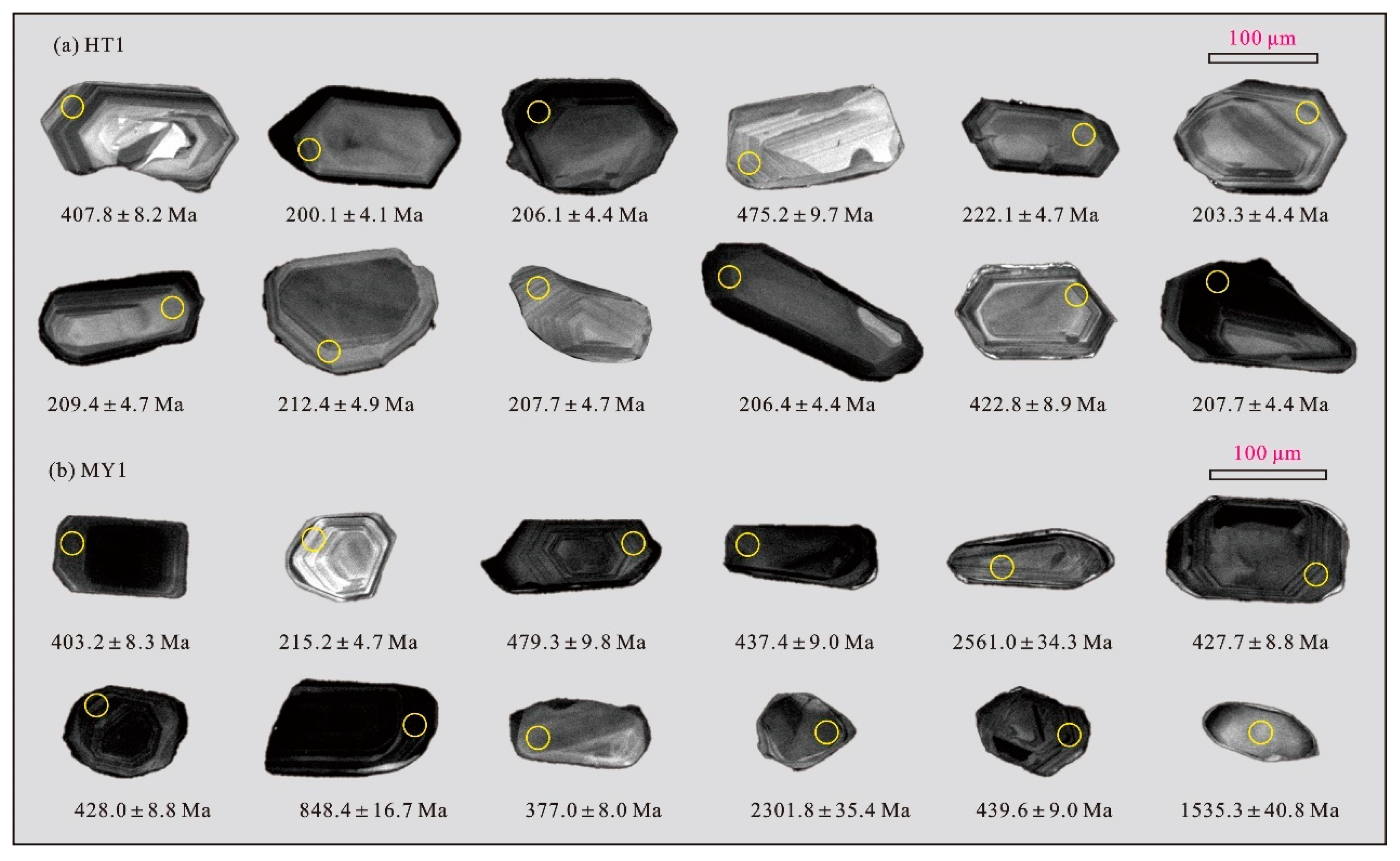
3.2. Detrital Zircon Analytical Methods

Zircon grains were separated from the samples using conventional heavy liquid and magnetic techniques at Micro-Macro Geochemistry Technology (Langfang) Co., Ltd., Langfang, China. Subsequently, 150 zircon grains from each sample were randomly selected, mounted in epoxy resin, and polished to expose their centers. The external morphology of all zircon grains was characterized by photographing them under transmitted and reflected light. Cathodoluminescence (CL) images were acquired using a Quanta 400FEG environmental scanning electron microscope (ESEM, Gatan, Pleasanton, CA, USA) equipped with an Oxford energy dispersive spectroscopy (EDS) system to evaluate the internal structures of the zircon grains. Based on these CL images, potential target sites for U-Pb analyses were identified.
U-Pb dating of zircon and trace element analysis were performed using laser ablation inductively coupled plasma mass spectrometry (LA-ICP-MS) at Micro-Macro Geochemistry Technology Co., Ltd. (Langfang, China). Laser ablation was conducted with a NewWave UP-213 Nd:YAG solid-state laser (NewWave, Fremont, CA, USA), while mass spectrometric measurements were obtained using an Agilent 7900 ICP-MS (Agilent Technologies, Santa Clara, CA, USA). During the analysis, helium was used as the carrier gas, and argon was employed as the makeup gas to optimize sensitivity. These gases were mixed via a T-connector before introduction into the ICP-MS system. The laser ablation spot size was set to 30 µm, with an energy density of 10 J/cm2 and a repetition rate of 10 Hz. The NIST SRM 610 glass reference material (National Institute of Standards and Technology, Gaithersburg, MD, USA) was utilized to ensure maximum sensitivity, minimal oxide formation, low background levels, and signal stability under optimal analytical conditions. Each analysis consisted of a 20 s background acquisition, followed by 40 s of sample ablation, and 30 s of washout time. Data acquisition employed a peak-jumping method with an integration time of 10 ms for 202Hg and 232Th, 20 ms for 204Pb and 206Pb, 30 ms for 207Pb, 15 ms for 208Pb and 238U, and 6 ms for other trace elements. The zircon standard 91,500 was used as the external standard for U-Pb isotopic ratio calibration, while the zircon standard Plesovice (337 Ma) served as the quality control standard. Trace element concentrations were calibrated using the international reference material NIST SRM 610. U-Pb isotopic ratios and elemental concentrations were processed using GLITTER 4.0, and concordia diagrams were generated using IsoplotR [27].
Approximately 90 zircon grains were selected from each sample for in situ analysis. For grains younger than 1000 Ma, the 206Pb/238U age was used, whereas for grains older than 1000 Ma, the 207Pb/206Pb age was employed. In the interpretation of detrital zircon ages, only isotopic data that were concordant or nearly concordant (<10% discordance) were considered.

4. Results

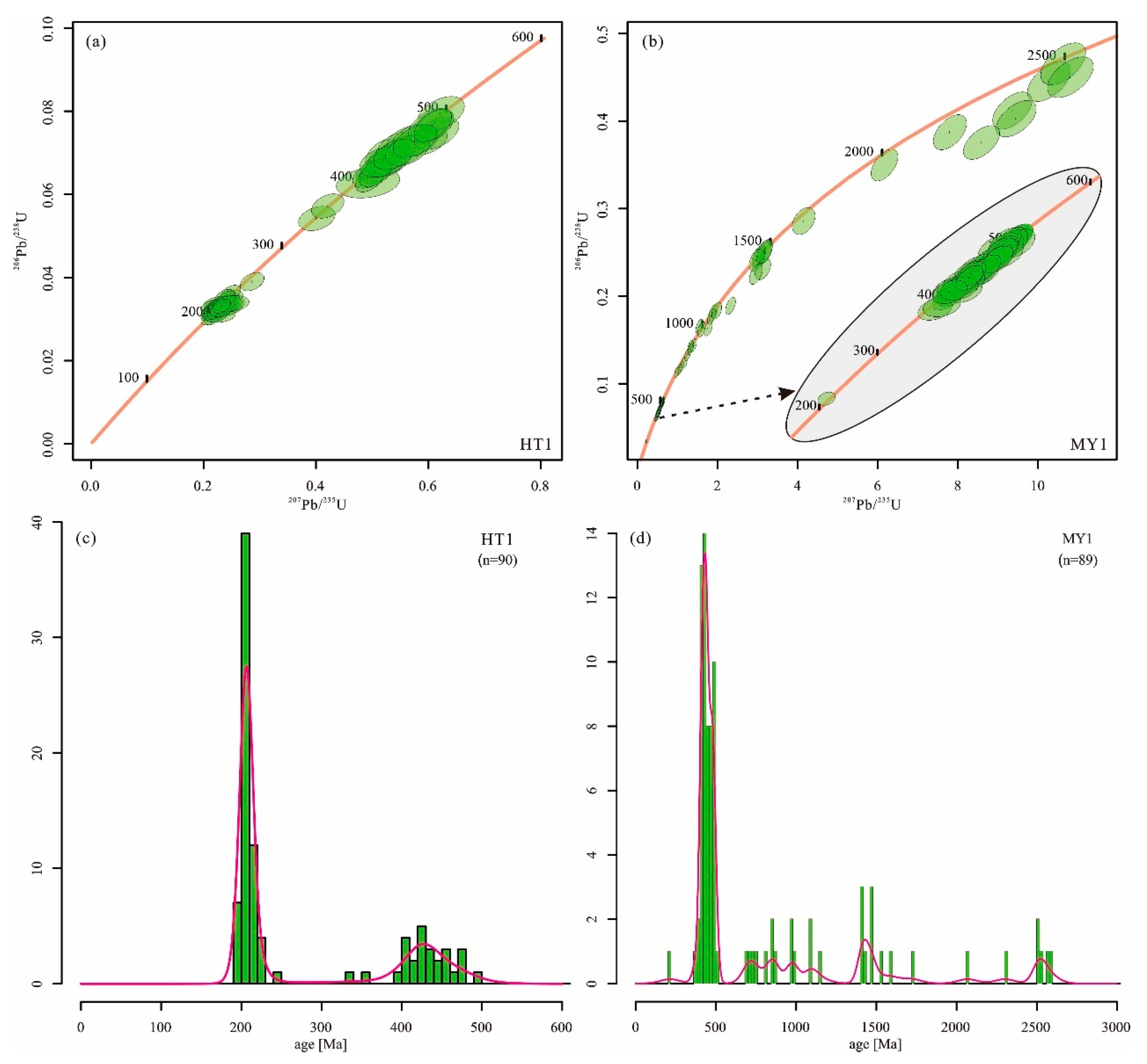
4.1. Detrital Zircon U-Pb Ages

A total of 180 zircon grains from two samples were analyzed for U-Pb isotopes, of which 179 grains with over 90% concordance were selected for further interpretation. The analytical results are presented in Supplementary Table S1. The CL imaging reveals that zircon grains from both samples are predominantly euhedral to subhedral and prismatic in shape (Figure 2). Their lengths generally range from 80 to 150 μm, with aspect ratios varying between 1:1 and 3:1. Most zircons display well-developed oscillatory zoning, a characteristic feature of magmatic crystallization.
In sample HT1 from the Yulongkash River, all 90 analyzed zircon grains yielded concordant ages, ranging from 492 Ma to 192 Ma (Figure 3a). Kernel density estimation (KDE) of the HT1 dataset reveals a prominent age peak at ~208 Ma, with a subordinate peak at ~418 Ma (Figure 3c).
In sample MY1 from the Karakash River, 89 out of 90 analyzed zircon grains yielded concordant ages, ranging from 2599 Ma to 215 Ma (Figure 3b). The majority of the grains (57) record Phanerozoic ages, mainly of Early Paleozoic age, while the remaining grains are of Precambrian age. The KDE of the MY1 dataset reveals a primary age peak at ~460 Ma, while the Precambrian population exhibits several less distinct peaks at approximately 800–1000 Ma, 1400 Ma, and 2500 Ma (Figure 3d).

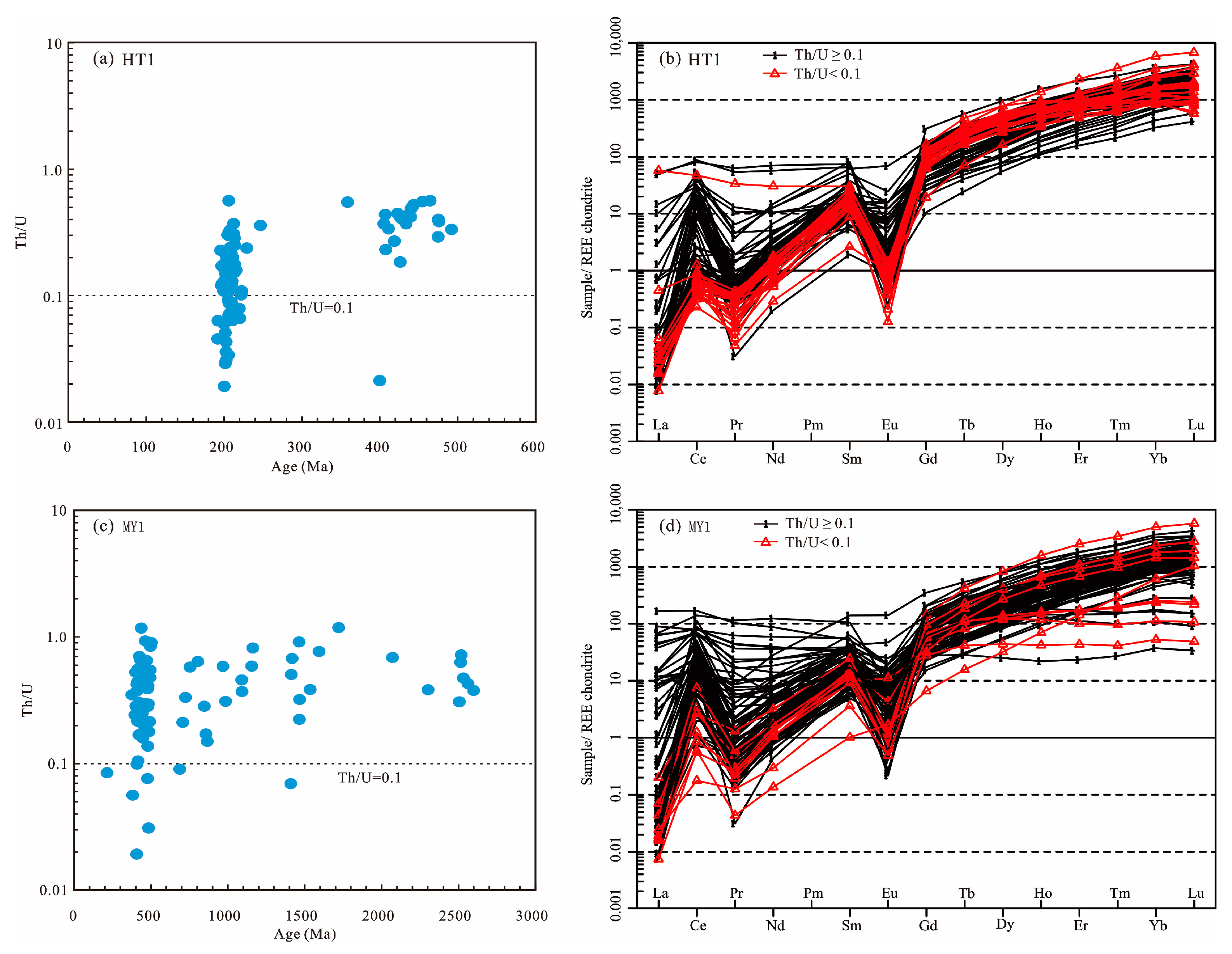
4.2. Detrital Zircon Trace Elements

The trace element compositions of detrital zircons are provided in Supplementary Table S2. In sample HT1, the majority of detrital zircons exhibit Th/U ratios greater than 0.1 (Figure 4a), with U concentrations ranging from 120 to 2333 ppm (average: 443 ppm). These zircons show significant depletion of light rare earth elements (LREEs) and enrichment in heavy rare earth elements (HREEs), alongside distinct negative Eu and Pr anomalies and pronounced positive Ce and Sm anomalies, which are indicative of a magmatic origin (Figure 4b). Notably, a subset of detrital zircons with ages around 210 Ma display lower Th/U ratios (<0.1) and higher U concentrations (390–5519 ppm; average: 1068 ppm). While the rare earth element (REE) patterns of most zircons in this subset remain consistent with magmatic zircons, a single grain shows metamorphic characteristics, including a relatively flat REE distribution, moderate to strong Eu anomalies, and subtle positive Ce anomalies.
In sample MY1, detrital zircons predominantly exhibit Th/U ratios >0.1, with a small proportion showing ratios <0.1 (Figure 4c). Both the zircons with Th/U ratios >0.1 and all those with ratios <0.1 display significant LREE depletion and HREE enrichment, along with distinct negative Eu and Pr anomalies and pronounced positive Ce and Sm anomalies, which are typical of magmatic origins (Figure 4d). Notably, a small subset of zircons with Th/U ratios >0.1 exhibit features consistent with metamorphic zircons, such as a relatively flat REE distribution, weak positive Ce anomalies, and moderate to strong Eu anomalies.

5. Discussions

5.1. Provenance Interpretation

The detrital zircon age spectra of river sand samples collected from the two tributaries of the Hotan River reveal significant variations, indicating distinct provenance characteristics. The zircon grains of the two river sand samples in this study are mostly elongate prismatic and euhedral–subhedral in shape (Figure 2), which indicates that these zircons are likely from nearby sources and largely rules out multiple recycling.
Geographical analysis shows that both tributaries originate from the WKOB on the southwestern margin of the Tarim Basin (Figure 1b). The primary potential source areas include the North Kunlun, South Kunlun, and Tianshuihai terranes. The North Kunlun terrane is predominantly overlain by Cenozoic sedimentary cover, with limited exposures of crystalline basement [6,21]. U-Pb geochronological data from exposed bedrock predominantly cluster in the Early Paleozoic (ca. 430–460 Ma) and Precambrian (Figure 5), specifically showing age peaks at ~0.8 Ga, ~1.8 Ga, and 2.2–2.4 Ga [14,21]. In the South Kunlun terrane, outcrops of igneous rocks are relatively abundant, with Early Paleozoic and Triassic lithologies being the most prevalent. Additionally, minor occurrences of Carboniferous intrusions and Precambrian rocks with ages of ~1.4 Ga and ~2.3–2.4 Ga are also present [6,21]. Notably, the Tianshuihai terrane displays U-Pb age spectra of exposed crystalline rocks predominantly clustered in the Triassic–Jurassic and Early Paleozoic, with subordinate age clusters identified in the Cenozoic, Late Cretaceous, and Precambrian [14,21].
The detrital zircons from sample HT1 of the Yulongkash River yield exclusively Phanerozoic ages, with a dominant peak at ~208 Ma and a secondary peak at ~418 Ma. By integrating the ages from potential source regions in the WKOB and the geological units traversed by the river, the Paleozoic zircon population likely originated primarily from the South Kunlun and North Kunlun terranes, while the Mesozoic peak is predominantly attributed to contributions from the Tianshuihai and South Kunlun terranes (Figure 5). Notably, sample HT1 contains Mesozoic zircons characterized by low Th/U ratios (<0.1) and elevated U concentrations, which align with zircon features reported from the 205 Ma Habake two-mica granite pluton in the Tianshuihai Terrane [30]. This consistency further supports the Tianshuihai Terrane as a critical source for the Mesozoic zircons in sample HT1.
In contrast, the Precambrian age distribution of sample MY1 from the Karakash River is relatively dispersed, correlating well with Precambrian ages documented in the North Kunlun, South Kunlun, and Tianshuihai terranes. Similarly, its most prominent Early Paleozoic age peak likely derives from these three terranes. However, the scarcity of Mesozoic zircons (only one grain identified) in sample MY1 suggests minimal contributions from the South Kunlun and Tianshuihai terranes (Figure 5). Consequently, the primary provenance of sample MY1 is inferred to be the North Kunlun Terrane.

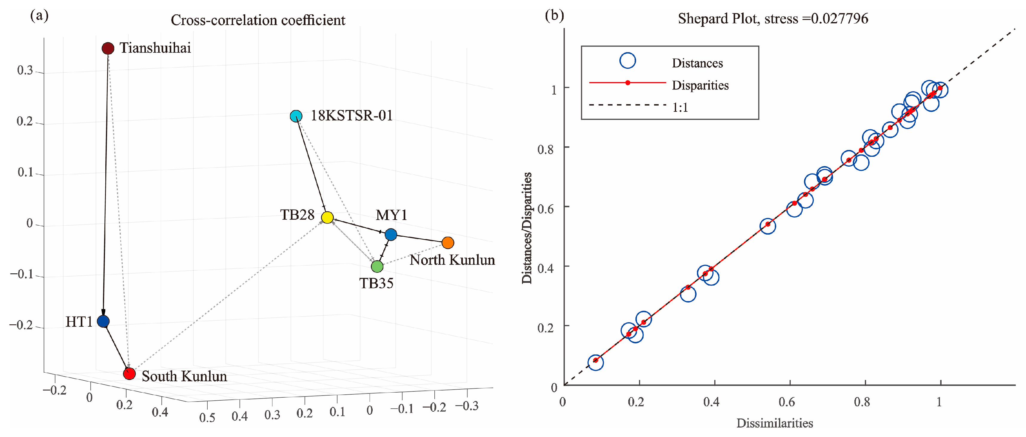
5.2. Comparison with the Published Detrital Zircon Data of Modern River Sediment from the Hotan River Drainage System

To improve understanding of the modern source-to-sink system in the Hotan River drainage system, we integrated three previously published detrital zircon U-Pb datasets from river sands with our new data for a comprehensive analysis. The published datasets include the following: (1) sample 18KSTSR-01 from an upper tributary channel of the Yulongkash River [6]; (2) sample TB35 from the Karakash River [5], near the location of our sample MY1; and (3) sample TB28 from the lower reaches of the Hotan River, downstream of the confluence of the Yulongkash and Karakash Rivers [5]. In addition to a visual comparison of detrital zircon age spectra, we conducted quantitative analyses using statistical software DZstats (version 2.31) and DZmds (version 1.11) [31,32].
Statistical analysis (Table 1) reveals systematic variations in the detrital zircon age distributions across the five samples, which correlate with their spatial locations and river connectivity [33,34]. Notably, the correlation coefficients between sample HT1 (middle Yulongkash River) and the other samples are relatively low, with significant statistical differences confirmed by the Kolmogorov–Smirnov and Kuiper tests. Conversely, the Karakash River samples MY1 and TB35 exhibit strong consistency. Sample 18KSTSR-01, from the upper Yulongkash River, shows moderate correlations with both the downstream Hotan River sample TB28 and Karakash River samples. Sample TB28, located at the confluence of the Yulongkash and Karakash Rivers, exhibits transitional characteristics, indicating mixed provenance from both tributaries, albeit with a slight residual difference compared to Karakash River inputs, as suggested by the results of the Kuiper test.
Furthermore, the Multidimensional Scaling (MDS) analysis visually represents the relationships among the detrital zircon age data, emphasizing both proximity and dissimilarity [32]. Figure 6a displays a 3D scatter plot of the cross-correlation coefficients, highlighting the spatial relationships between the samples. Figure 6b presents the Shepard plot, illustrating the correlation between distances and dissimilarities. The blue circles represent distances, while the red lines indicate dissimilarities. The plot shows a close alignment between these two measures, with a stress value of 0.027796, indicating a good fit for the MDS model. Distinct groupings are observed in the MDS plot, with sample HT1 clearly separated from the others. This sample exhibits a stronger affinity with the Tianshuihai and South Kunlun terranes. Conversely, samples MY1, TB35, TB28, and 18KSTSR-01 cluster with a higher affinity to the North Kunlun terrane, while showing a weaker relationship with the South Kunlun terrane.
The observed provenance variations, particularly the marked discrepancies exhibited by sample HT-1 compared to other samples and prior research findings, are primarily controlled by the following factors: (1) spatial heterogeneity in bedrock ages across the catchment, particularly between the Yulongkash and Karakash drainages; (2) variations in mixing efficiencies, influenced by fluvial geomorphology, such as channel confluences and sediment storage/reworking zones; and (3) temporal and spatial variations in flood activity, affecting sediment delivery from specific source terrains [33,34,35,36]. These systematic variations highlight the importance of strategic sampling in fluvial systems when interpreting detrital zircon records and reconstructing source-to-sink systems, especially in confluent river systems draining geologically diverse terrains.

5.3. Tectonic Implications

The WKOB preserves key records of the evolution of the Proto-to-Paleo-Tethyan Oceans. However, the timing of the terminal closure of these ocean basins remains a subject of ongoing debate [18,20,21,37,38]. Various studies have proposed different closure times for the Proto-Tethys Ocean in the WKOB, with estimates ranging from the Ordovician, middle Silurian, to the Devonian [19,21,37,39,40]. Similarly, the closure of the Paleo-Tethys Ocean between the South Kunlun and Tianshuihai terranes has been dated to the Late Permian, Early to Middle Triassic, Late Triassic, and Jurassic [19,20,30,41]. Recent advances in reconstructing the evolution of orogenic crustal thickness using detrital zircon trace element data have proven to be an effective method for constraining the timing of orogeny and ocean basin closure, providing new insights into these ongoing disputes [42,43]. This approach utilizes zircon Eu anomalies (Eu/Eu*) as a crustal thickness proxy. The empirical relationship is defined as follows: crustal thickness (km) = (84.2 ± 9.2) × Eu/Eu* + (24.5 ± 3.3) [42,43].
In this study, we analyzed river sand samples from the Hotan River drainage system, identifying 84 Phanerozoic detrital zircons suitable for crustal thickness estimation using updated screening protocols [43]. The crustal thickness reconstruction reveals that between 500 and 350 Ma, the crust initially thickened and then began to thin, reaching a maximum thickness of approximately 80 km between 420 and 440 Ma (Figure 7). This trend aligns with the classical orogenic cycle, where crustal thickening corresponds to compressional regimes associated with oceanic subduction and closure, while subsequent thinning is indicative of post-collisional extensional processes [44,45]. Based on this pattern, we propose that the terminal closure of the Proto-Tethys Ocean in the WKOB occurred around 420–440 Ma, with the peak crustal thickness of 80 km representing the climax of syn-collisional crustal shortening. This inference shows good consistency with recent constraints on the closure timing of the Proto-Tethys Ocean derived from magmatic and sedimentary records [21]. In contrast, Mesozoic zircons predominantly indicate a stabilized crustal thickness of 25-35 km. However, three Late Triassic zircons (ca. 210 Ma) exhibit anomalously thick crust, with estimates ranging from 40 to 60 km (Figure 7). Applying the same tectonic logic, we interpret this crustal thickness anomaly as evidence for the closure of the Paleo-Tethys Ocean at ca. 210 Ma. Furthermore, this interpretation is corroborated by recent constraints on the timing of the Paleo-Tethys Ocean closure derived from coeval magmatic, metamorphic, and sedimentary records in the study region [30].

6. Conclusions

This study integrates detrital zircon U-Pb geochronology and trace element data from the Yulongkash and Karakash Rivers to elucidate provenance patterns and tectonic evolution in the southwestern Tarim Basin. Key findings include:
(1)
The findings reveal significant spatial variations in detrital zircon age spectra, which correlate with the geological heterogeneity of the source regions, including the North Kunlun, South Kunlun, and Tianshuihai terranes. The Yulongkash River predominantly receives sediments from the South Kunlun and Tianshuihai terranes, marked by Triassic (~208 Ma) and Early Paleozoic (~418 Ma) zircon populations. In contrast, the Karakash River sediments are largely derived from the North Kunlun Terrane, evidenced by Early Paleozoic (~460 Ma) and scattered Precambrian zircons.
(2)
The integration of our new data with previously published datasets reveals systematic downstream mixing of detrital signals, modulated by spatial heterogeneity in bedrock ages, fluvial geomorphology, and sediment mixing efficiencies. The Hotan River’s confluence zone exhibits transitional zircon age spectra, blending inputs from both tributaries while retaining subtle provenance biases. These results underscore the importance of detailed sampling and statistical analysis in reconstructing the complexities of sediment transport and provenance in tectonically active settings.
(3)
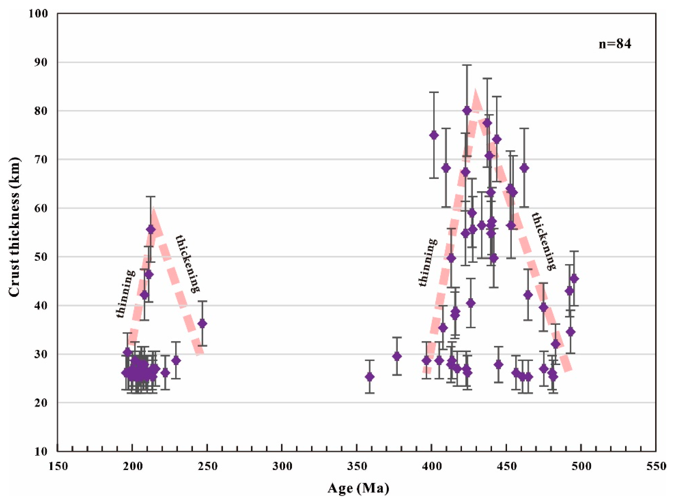
From a tectonic perspective, the study contributes to ongoing debates regarding the closure timing of the Paleo-Tethys and Proto-Tethys oceans in the WKOB. The crustal thickness reconstructions based on detrital zircon trace element data provide new constraints on the timing of orogenic events, suggesting that the terminal closure of the Proto-Tethys Ocean occurred around 420–440 Ma, with the closure of the Paleo-Tethys Ocean occurring during the Late Triassic (ca. 210 Ma).

Supplementary Materials

The following supporting information can be downloaded at: https://www.mdpi.com/article/10.3390/min15050509/s1, Table S1: U-Pb isotopic data for detrital zircons of two river sand samples from the Hotan River Drainage System; Table S2: Trace element data for detrital zircons of two river sand samples from the Hotan River Drainage System.

Author Contributions

Conceptualization, M.Q. and S.Z.; Data curation, J.X.; Formal analysis, N.L., M.X. and S.Z.; Funding acquisition, M.Q. and S.Z.; Investigation, M.Q., Q.G., Q.X., J.X., S.H., L.Z. and Y.J.; Methodology, Q.G., N.L., S.H., L.Z., M.X., Y.J. and S.Z.; Project administration, S.Z.; Resources, Q.G., Q.X., J.X., S.H. and S.Z.; Visualization, Q.X.; Writing–original draft, M.Q., Q.G., N.L., L.Z., and S.Z. All authors have read and agreed to the published version of the manuscript.

Funding

This work is financially supported by the Nuclear Technology R&D Program (No. HTLM2101).

Data Availability Statement

The data that support the findings of this study are available from the corresponding author upon reasonable request.

Acknowledgments

We would like to express our sincere gratitude to the anonymous reviewers for their insightful comments and constructive suggestions, which greatly improved the quality of this manuscript.

Conflicts of Interest

The authors declare no conflicts of interest.

References

  1. Cao, K.; Wang, G.-C.; Bernet, M.; van der Beek, P.; Zhang, K.-X. Exhumation history of the West Kunlun Mountains, northwestern Tibet: Evidence for a long-lived, rejuvenated orogen. Earth Planet. Sci. Lett. 2015, 432, 391–403. [Google Scholar] [CrossRef]
  2. Matte, P. Tectonics of Western Tibet, between the Tarim and the Indus. Earth Planet. Sci. Lett. 1996, 142, 311–330. [Google Scholar] [CrossRef]
  3. Yin, A. Cenozoic tectonic evolution of Asia: A preliminary synthesis. Tectonophysics 2010, 488, 293–325. [Google Scholar] [CrossRef]
  4. Laborde, A.; Barrier, L.; Simoes, M.; Li, H.; Coudroy, T.; Van der Woerd, J.; Tapponnier, P. Cenozoic deformation of the Tarim Basin and surrounding ranges (Xinjiang, China): A regional overview. Earth-Sci. Rev. 2019, 197, 102891. [Google Scholar] [CrossRef]
  5. Rittner, M.; Vermeesch, P.; Carter, A.; Bird, A.; Stevens, T.; Garzanti, E.; Andò, S.; Vezzoli, G.; Dutt, R.; Xu, Z.; et al. The provenance of Taklamakan desert sand. Earth Planet. Sci. Lett. 2016, 437, 127–137. [Google Scholar] [CrossRef]
  6. Liang, S.; Lin, X.; Li, C.; Wei, X.; Qu, Y.; An, K.; Chen, C.; Yang, X.; Li, Y.; Zhang, L.; et al. Northward expansion of the West Kunlun orogenic belt during the Cenozoic and its implications for the evolution of the northwest Tibetan Plateau: Constraints from sediment dispersal patterns in the Buya Basin, China. Palaeogeogr. Palaeoclimatol. Palaeoecol. 2024, 647, 112255. [Google Scholar] [CrossRef]
  7. Chen, X.; Chen, H.; Lin, X.; Cheng, X.; Chen, C.; Rembe, J.; Zou, H. Late Cenozoic deformation of the northeastern Pamir and the west Kunlun Mountains: Insights from anisotropy of magnetic fabrics and sedimentary analysis. Palaeogeogr. Palaeoclimatol. Palaeoecol. 2024, 655, 112521. [Google Scholar] [CrossRef]
  8. Clift, P.D.; Zheng, H.; Carter, A.; Böning, P.; Jonell, T.; Schorr, H.; Shan, X.; Pahnke, K.; Wei, X.; Rittenour, T. Controls on erosion in the western Tarim Basin: Implications for the uplift of northwest Tibet and the Pamir Controls on erosion in the western Tarim Basin: Implications for the uplift of northwest Tibet and the Pamir. Geosphere 2017, 13, 1747–1765. [Google Scholar] [CrossRef]
  9. Sun, J.; Xiao, W.; Windley, B.F.; Ji, W.; Fu, B.; Wang, J.; Jin, C. Provenance change of sediment input in the northeastern foreland of Pamir related to collision of the Indian Plate with the Kohistan-Ladakh arc at around 47 Ma. Tectonics 2016, 35, 315–338. [Google Scholar] [CrossRef]
  10. Yang, W.; Fu, L.; Wu, C.; Song, Y.; Jiang, Z.; Luo, Q.; Zhang, Z. Journal of Asian Earth Sciences U-Pb ages of detrital zircon from Cenozoic sediments in the southwestern Tarim Basin, NW China: Implications for Eocene–Pliocene source-to-sink relations and new insights into Cretaceous–Paleogene magmatic sources. J. Asian Earth Sci. 2018, 156, 26–40. [Google Scholar] [CrossRef]
  11. Gehrels, G. Detrital Zircon U-Pb Geochronology Applied to Tectonics. Annu. Rev. Earth Planet. Sci. 2014, 42, 127–149. [Google Scholar] [CrossRef]
  12. Zhang, S.; Liu, C.; Bai, J.; Wang, J.; Ming, M.A.; Guan, Y.; Peng, H. Provenance Variability of the Triassic Strata in the Turpan-Hami Basin: Detrital Zircon Record of Indosinian Tectonic Reactivation in the Eastern Tianshan. Acta Geol. Sin. 2019, 93, 1850–1868. [Google Scholar] [CrossRef]
  13. Tang, J.; Zhang, Z.; Xue, J.; Liu, B.; Chen, Y.; Zhang, S. Permo-Carboniferous provenance shifts at the northern margin of the North China Craton and their tectonic implications: Detrital zircon U–Pb–Hf records from central Inner Mongolia. Gondwana Res. 2021, 95, 134–148. [Google Scholar] [CrossRef]
  14. Zhang, Z.; Sun, J.; Zhang, B.; Ren, Z. Cenozoic source-to-sink relations between the West Kunlun Mountains and SW Tarim Basin: Evidence from an integrated provenance analysis. Palaeogeogr. Palaeoclimatol. Palaeoecol. 2023, 632, 111858. [Google Scholar] [CrossRef]
  15. Wang, E.; Wan, J.; Liu, J. Late Cenozoic geological evolution of the foreland basin bordering the West Kunlun range in Pulu area: Constraints on timing of uplift of northern margin of the Tibetan Plateau. J. Geophys. Res. Solid Earth 2003, 108, 2401. [Google Scholar] [CrossRef]
  16. Cheng, X.; Chen, H.; Lin, X.; Wu, L.; Gong, J. Geometry and Kinematic Evolution of the Hotan-Tiklik Segment of the Western Kunlun Thrust Belt: Constrained by Structural Analyses and Apatite Fission Track Thermochronology. J. Geol. 2017, 125, 65–82. [Google Scholar] [CrossRef]
  17. Luo, H.; Xiong, F.; Huang, H.; Yan, D.; Zhang, D.; Li, F.; Hou, M. Provenance of Late Carboniferous–Triassic clastic rocks in the Western Kunlun orogenic belt, western China: Implications for the tectonic evolution of the Paleo-Tethys Ocean. J. Asian Earth Sci. 2024, 267, 106162. [Google Scholar] [CrossRef]
  18. Xiao, W.; Windley, B.; Hao, J.; Li, J. Arc-ophiolite obduction in the Western Kunlun Range (China): Implications for the Palaeozoic evolution of central Asia. J. Geol. Soc. 2002, 159, 517–528. [Google Scholar] [CrossRef]
  19. Mattern, F.; Schneider, W. Suturing of the Proto- and Paleo-Tethys oceans in the western Kunlun (Xinjiang, China). J. Asian Earth Sci. 2000, 18, 637–650. [Google Scholar] [CrossRef]
  20. Xiao, W.; Han, F.; Windley, B.F.; Yuan, C.; Zhou, H.; Li, J. Multiple Accretionary Orogenesis and Episodic Growth of Continents: Insights from the Western Kunlun Range, Central Asia. Int. Geol. Rev. 2003, 45, 303–328. [Google Scholar] [CrossRef]
  21. Wang, P.; Zhao, G.; Han, Y.; Liu, Q.; Yao, J.; Yu, S.; Li, J. Timing of the final closure of the Proto-Tethys Ocean: Constraints from provenance of early Paleozoic sedimentary rocks in West Kunlun, NW China. Gondwana Res. 2020, 84, 151–162. [Google Scholar] [CrossRef]
  22. Li, G.; Sandiford, M.; Fang, A.; Kohn, B.; Sandiford, D.; Fu, B.; Zhang, T.; Cao, Y.; Chen, F. Multi-stage exhumation history of the West Kunlun orogen and the amalgamation of the Tibetan Plateau. Earth Planet. Sci. Lett. 2019, 528, 115833. [Google Scholar] [CrossRef]
  23. Chang, J.; Liu, K.; Yuan, W.; Liu, J.; Zhang, L.; Chen, C. Tectono-sedimentary evolution of the southwestern Tarim Basin in the cretaceous in response to basin-range coupling: New insights from basin and landscape dynamics modeling. Palaeogeogr. Palaeoclimatol. Palaeoecol. 2024, 637, 112017. [Google Scholar] [CrossRef]
  24. Li, C.; Chen, H.; Zhang, F.; Lin, X.; Cheng, X.; Li, Y.; Chen, C.; Zhang, L.; Shang, J.; Sun, D.; et al. Cenozoic basin-filling evolution of the SW Tarim Basin and its implications for the uplift of western Kunlun: Insights from (seismo)stratigraphy. Palaeogeogr. Palaeoclimatol. Palaeoecol. 2021, 562, 110149. [Google Scholar] [CrossRef]
  25. Baby, G.; Simoes, M.; Barrier, L.; Guilbaud, C.; Li, H.; Van der Woerd, J. Kinematics of Cenozoic Shortening of the Hotan Anticline Along the Northwestern Margin of the Tibetan Plateau (Western Kunlun, China). Tectonics 2022, 41, e2021TC006928. [Google Scholar] [CrossRef]
  26. Fu, X.; Shen, B.; Dong, Z.; Zhang, X. Assessing the impacts of changing climate and human activities on streamflow in the Hotan River, China. J. Water Clim. Change 2020, 11, 166–177. [Google Scholar] [CrossRef]
  27. Vermeesch, P. IsoplotR: A free and open toolbox for geochronology. Geosci. Front. 2018, 9, 1479–1493. [Google Scholar] [CrossRef]
  28. Boynton, W.V. Cosmochemistry of the Rare Earth Elements: Meteorite Studies. Dev. Geochem. 1984, 2, 63–114. [Google Scholar]
  29. Wang, P.; Zhao, G.; Han, Y.; Liu, Q.; Yao, J.; Li, J. Petrogenesis of Ordovician granitoids in Western Kunlun, NW Tibetan Plateau: Insights into the evolution of the Proto-Tethys Ocean. Bulletin 2021, 133, 1071–1089. [Google Scholar] [CrossRef]
  30. Wang, K.; Wang, H.; Bai, H.; Gao, H.; Zhang, X.; Zhu, B.; Wang, Z.; Huang, L.; Zhang, S. Petrogenesis of the Late Triassic Habake granitic pluton, the West Kunlun Orogen, Western China: Tectonic implications for the evolution of the Paleo-Tethys. J. Asian Earth Sci. 2024, 266, 106130. [Google Scholar] [CrossRef]
  31. Saylor, J.E.; Sundell, K.E. Quantifying comparison of large detrital geochronology data sets. Geosphere 2016, 12, 203–220. [Google Scholar] [CrossRef]
  32. Saylor, J.E.; Jordan, J.C.; Sundell, K.E.; Wang, X.; Wang, S.; Deng, T. Topographic growth of the Jishi Shan and its impact on basin and hydrology evolution, NE Tibetan Plateau. Basin Res. 2018, 30, 544–563. [Google Scholar] [CrossRef]
  33. Castillo, P.; Bahlburg, H.; Fernandez, R.; Fanning, C.M.; Berndt, J. The European continental crust through detrital zircons from modern rivers: Testing representativity of detrital zircon U-Pb geochronology. Earth-Sci. Rev. 2022, 232, 104145. [Google Scholar] [CrossRef]
  34. Saylor, J.E.; Knowles, J.N.; Horton, B.K.; Nie, J.; Mora, A. Mixing of Source Populations Recorded in Detrital Zircon U-Pb Age Spectra of Modern River Sands. J. Geol. 2013, 121, 17–33. [Google Scholar] [CrossRef]
  35. Capaldi, T.N.; Horton, B.K.; McKenzie, N.R.; Stockli, D.F.; Odlum, M.L. Sediment provenance in contractional orogens: The detrital zircon record from modern rivers in the Andean fold-thrust belt and foreland basin of western Argentina. Earth Planet. Sci. Lett. 2017, 479, 83–97. [Google Scholar] [CrossRef]
  36. Mason, C.C.; Fildani, A.; Gerber, T.; Blum, M.D.; Clark, J.D.; Dykstra, M. Climatic and anthropogenic influences on sediment mixing in the Mississippi source-to-sink system using detrital zircons: Late Pleistocene to recent. Earth Planet. Sci. Lett. 2017, 466, 70–79. [Google Scholar] [CrossRef]
  37. Allen, M.B.; Song, S.; Wang, C.; Zeng, R.; Wen, T. An oblique subduction model for closure of the Proto-Tethys and Palaeo-Tethys oceans and creation of the Central China Orogenic Belt. Earth-Sci. Rev. 2023, 240, 104385. [Google Scholar] [CrossRef]
  38. Li, S.; Zhao, S.; Liu, X.; Cao, H.; Yu, S.; Li, X.; Somerville, I. Earth-Science Reviews Closure of the Proto-Tethys Ocean and Early Paleozoic amalgamation of microcontinental blocks in East Asia. Earth-Sci. Rev. 2018, 186, 37–75. [Google Scholar] [CrossRef]
  39. Yuan, C.; Sun, M.; Zhou, M.; Zhou, H.; Xiao, W.; Li, J. Tectonic Evolution of the West Kunlun: Geochronologic and Geochemical Constraints from Kudi Granitoids. Int. Geol. Rev. 2002, 44, 653–669. [Google Scholar] [CrossRef]
  40. Zhang, C.; Zou, H.; Ye, X.; Chen, X. Lithos Timing of subduction initiation in the Proto-Tethys Ocean: Evidence from the Cambrian gabbros from the NE Pamir Plateau. Lithos 2018, 314–315, 40–51. [Google Scholar] [CrossRef]
  41. Jiang, Y.-H.; Jia, R.-Y.; Liu, Z.; Liao, S.-Y.; Zhao, P.; Zhou, Q. Origin of Middle Triassic high-K calc-alkaline granitoids and their potassic microgranular enclaves from the western Kunlun orogen, northwest China: A record of the closure of Paleo-Tethys. Lithos 2013, 156–159, 13–30. [Google Scholar] [CrossRef]
  42. Tang, M.; Ji, W.Q.; Chu, X.; Wu, A.; Chen, C. Reconstructing crustal thickness evolution from europium anomalies in detrital zircons. Geology 2021, 49, 76–80. [Google Scholar] [CrossRef]
  43. Tang, M.; Guo, Z.; Cao, W.; Chu, X. Revisiting zircon Eu anomaly as a proxy for crustal thickness: A case study of the Sierra Nevada Batholith. Earth Planet. Sci. Lett. 2024, 643, 118897. [Google Scholar] [CrossRef]
  44. Brudner, A.; Jiang, H.; Chu, X.; Tang, M. Crustal thickness of the Grenville orogen: A Mesoproterozoic Tibet? Geology 2022, 50, 402–406. [Google Scholar] [CrossRef]
  45. Zhu, D.-C.; Wang, Q.; Weinberg, R.F.; Cawood, P.A.; Chung, S.-L.; Zheng, Y.-F.; Zhao, Z.; Hou, Z.-Q.; Mo, X.-X. Interplay between oceanic subduction and continental collision in building continental crust. Nat. Commun. 2022, 13, 7141. [Google Scholar] [CrossRef]
Figure 1. Tectonic setting of the southwestern margin of the Tarim Basin and the West Kunlun Orogenic Belt (a); geological map and sample locations of the Hotan River Drainage Area and adjacent areas (b). Modified after references [1,14] BNS: Bangong–Nujiang Suture; IYS: Indus–Yarlung Suture; MPT: Main Pamir Thrust; JS: Jinsha Suture; KS: Kunlun Suture; KuS: Kudi Suture; KSZ: Kuke ductile Shear Zone; KYTS: Kashgar–Yecheng Transfer System.
Minerals 15 00509 g001
Figure 2. Representative cathodoluminescence (CL) images of detrital zircons from river sand samples in the Yulongkash (a) and Karakash (b) Rivers.
Minerals 15 00509 g002
Figure 3. U-Pb concordia diagrams (a,b) and kernel density estimation (KDE) plots (c,d) of detrital zircons from river sand samples in the Yulongkash and Karakash Rivers.
Minerals 15 00509 g003
Figure 4. U-Pb age vs. Th/U ratio plot of detrital zircons (a,c) and chondrite-normalized rare earth element (REE) patterns (b,d) of detrital zircons from river sand samples in the Yulongkash and Karakash Rivers. The normalization values of chondrite are from reference [28].
Minerals 15 00509 g004
Figure 5. KDE of U-Pb ages of detrital zircons from river sand samples (Yulongkash River: HT1 (a) and 18KSTSR-01 (b); Karakash River: MY1 (c) and TB35 (d); lower reaches of the Hotan River: TB28 (e)) in the Hotan River drainage system and KDE of crystallization ages of magmatic rocks from potential source regions. Data source: 18KSTSR-01 [6]; TB28 and TB35 [5]; potential source regions: North Kunlun (f), South Kunlun (g), and Tianshuihai (h) terranes [29].
Minerals 15 00509 g005
Figure 6. (a) Multidimensional Scaling (MDS) plot of river sand samples and age spectra of potential source areas in the Hotan River drainage system, and (b) associated cross-correlation Shepard plot using the cross-correlation coefficient.
Minerals 15 00509 g006
Figure 7. Phanerozoic crustal thickness evolution of the West Kunlun Orogenic Belt reconstructed from detrital zircon trace elements in the Hotan River drainage system.
Minerals 15 00509 g007
Table 1. Comparative statistical analysis of detrital zircon U-Pb age spectra from river sediments in the Hotan River drainage system.
Cross Correlation Coefficient
HT118KSTSR-01MY1TB35TB28
HT11.000.040.040.050.06
18KSTSR-010.041.000.640.710.81
MY10.040.641.000.920.84
TB350.050.710.921.000.83
TB280.060.810.840.831.00
Likeness value
HT11.000.240.300.330.34
18KSTSR-010.241.000.550.630.67
MY10.300.551.000.730.69
TB350.330.630.731.000.72
TB280.340.670.690.721.00
Similarity value
HT11.000.400.480.520.54
18KSTSR-010.401.000.820.860.89
MY10.480.821.000.880.85
TB350.520.860.881.000.90
TB280.540.890.850.901.00
K-S test p value
HT11.000.000.000.000.00
18KSTSR-010.001.000.000.000.00
MY10.000.001.000.100.05
TB350.000.000.101.000.50
TB280.000.000.050.501.00
K-S test D statistic
HT10.000.680.710.660.64
18KSTSR-010.680.000.260.300.32
MY10.710.260.000.160.19
TB350.660.300.160.000.10
TB280.640.320.190.100.00
Kuiper test p value
HT11.000.000.000.000.00
18KSTSR-010.001.000.000.000.00
MY10.000.001.000.280.23
TB350.000.000.281.000.16
TB280.000.000.230.161.00
Kuiper test V statistic
HT10.000.680.710.670.65
18KSTSR-010.680.000.390.340.32
MY10.710.390.000.190.20
TB350.670.340.190.000.19
TB280.650.320.200.190.00
Disclaimer/Publisher’s Note: The statements, opinions and data contained in all publications are solely those of the individual author(s) and contributor(s) and not of MDPI and/or the editor(s). MDPI and/or the editor(s) disclaim responsibility for any injury to people or property resulting from any ideas, methods, instructions or products referred to in the content.

