
Petrographic and Geochemical Analysis of Indus Sediments: Implications for Placer Gold Deposits, Peshawar Basin, NW Himalaya, Pakistan

 ,
,  ,
, 
Abstract
1. Introduction
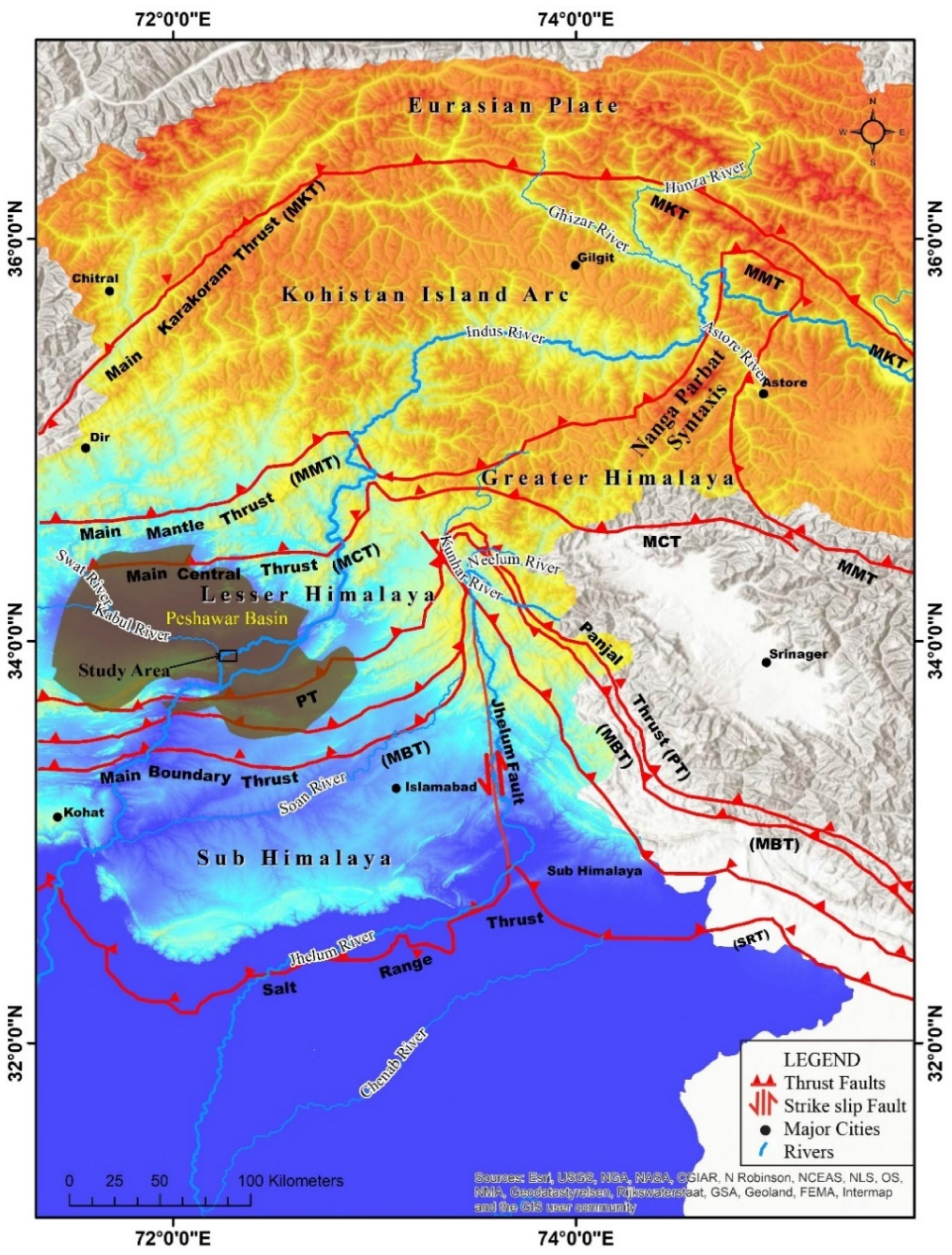
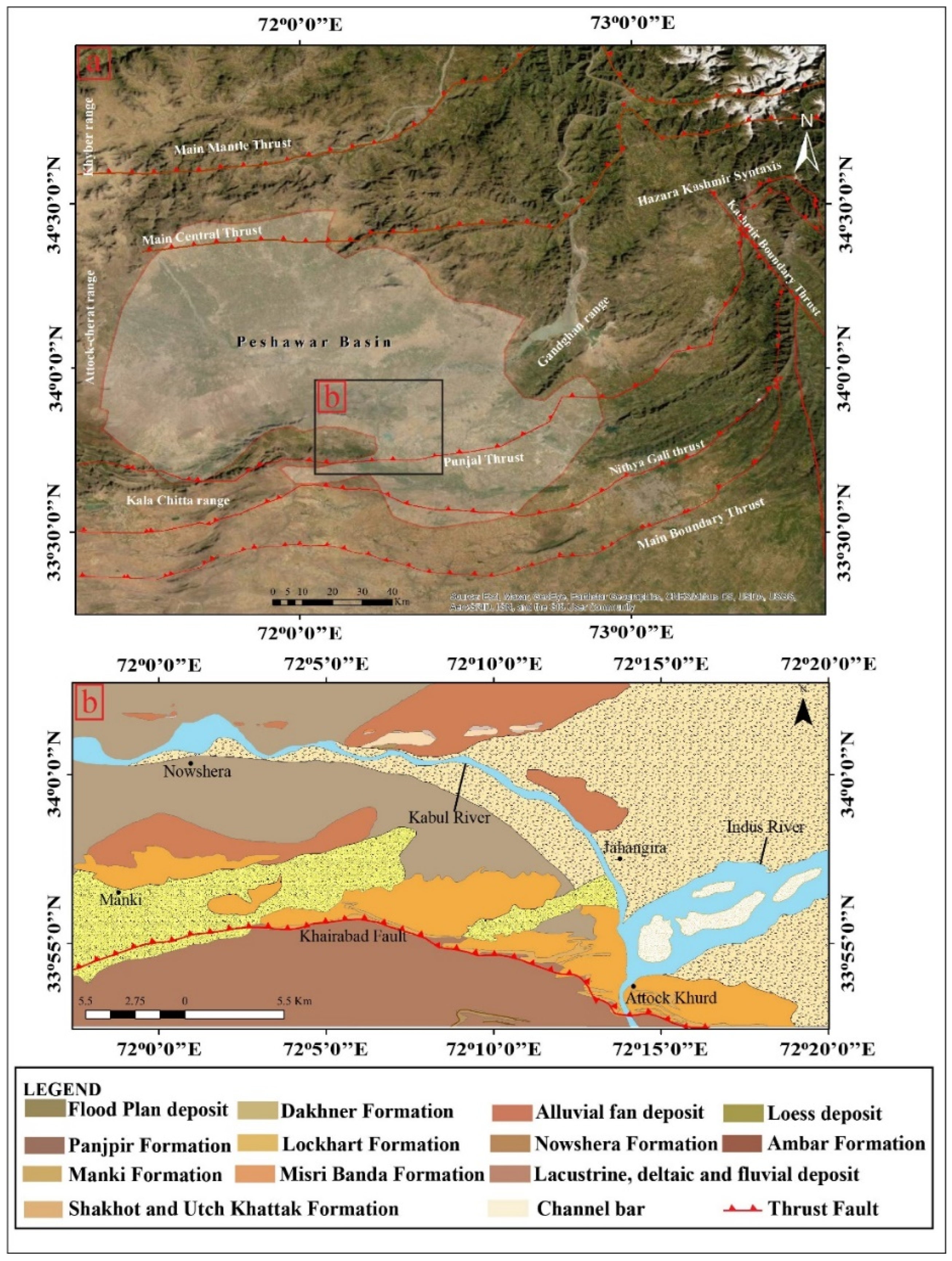
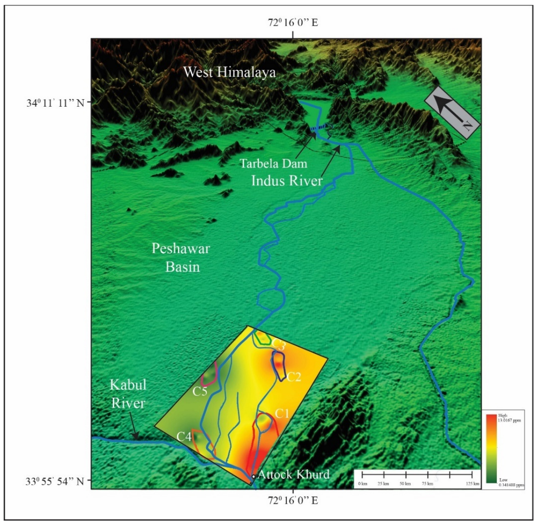
2. Regional Geology
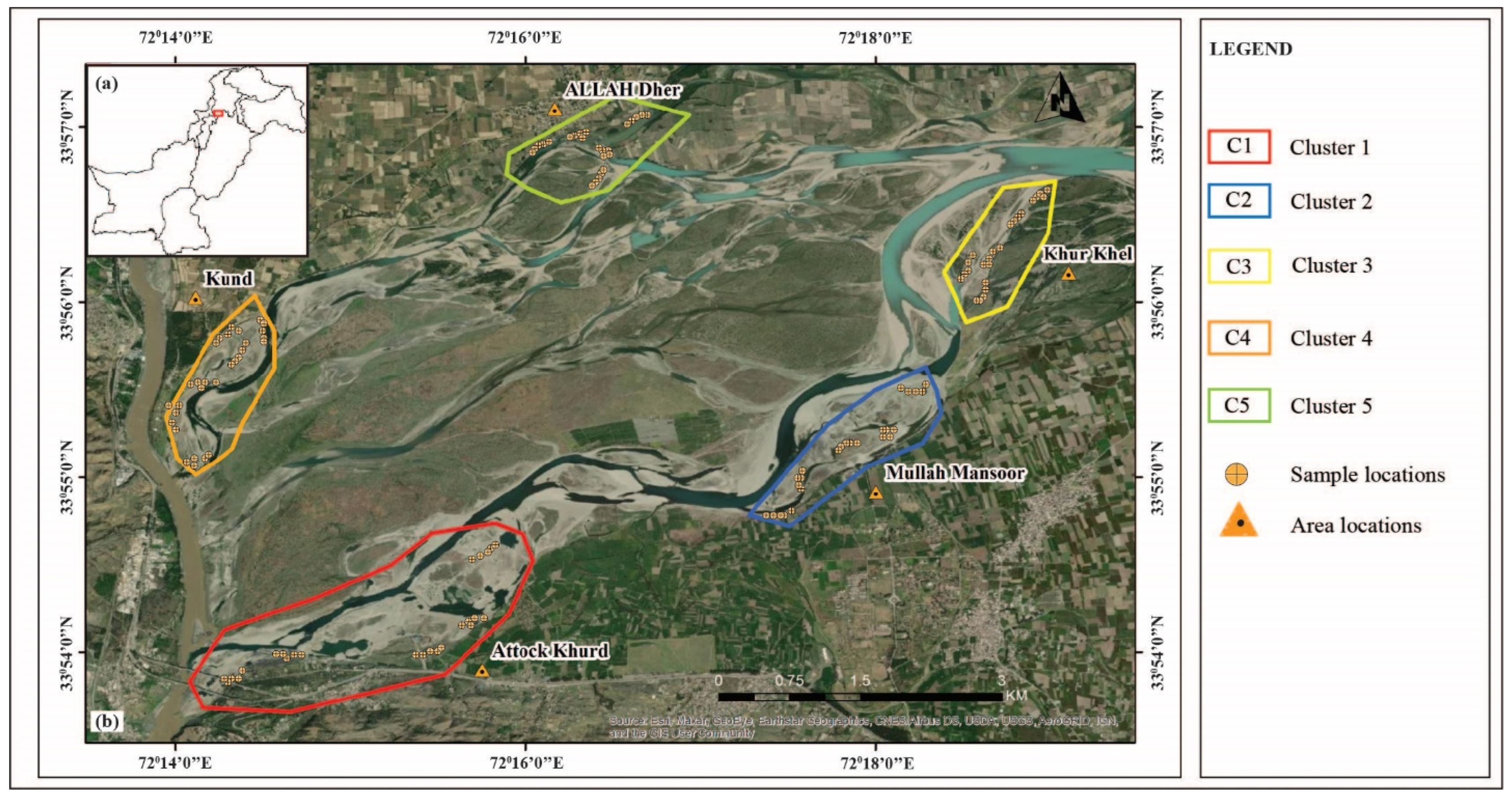
3. Materials and Methods
4. Results and Discussion
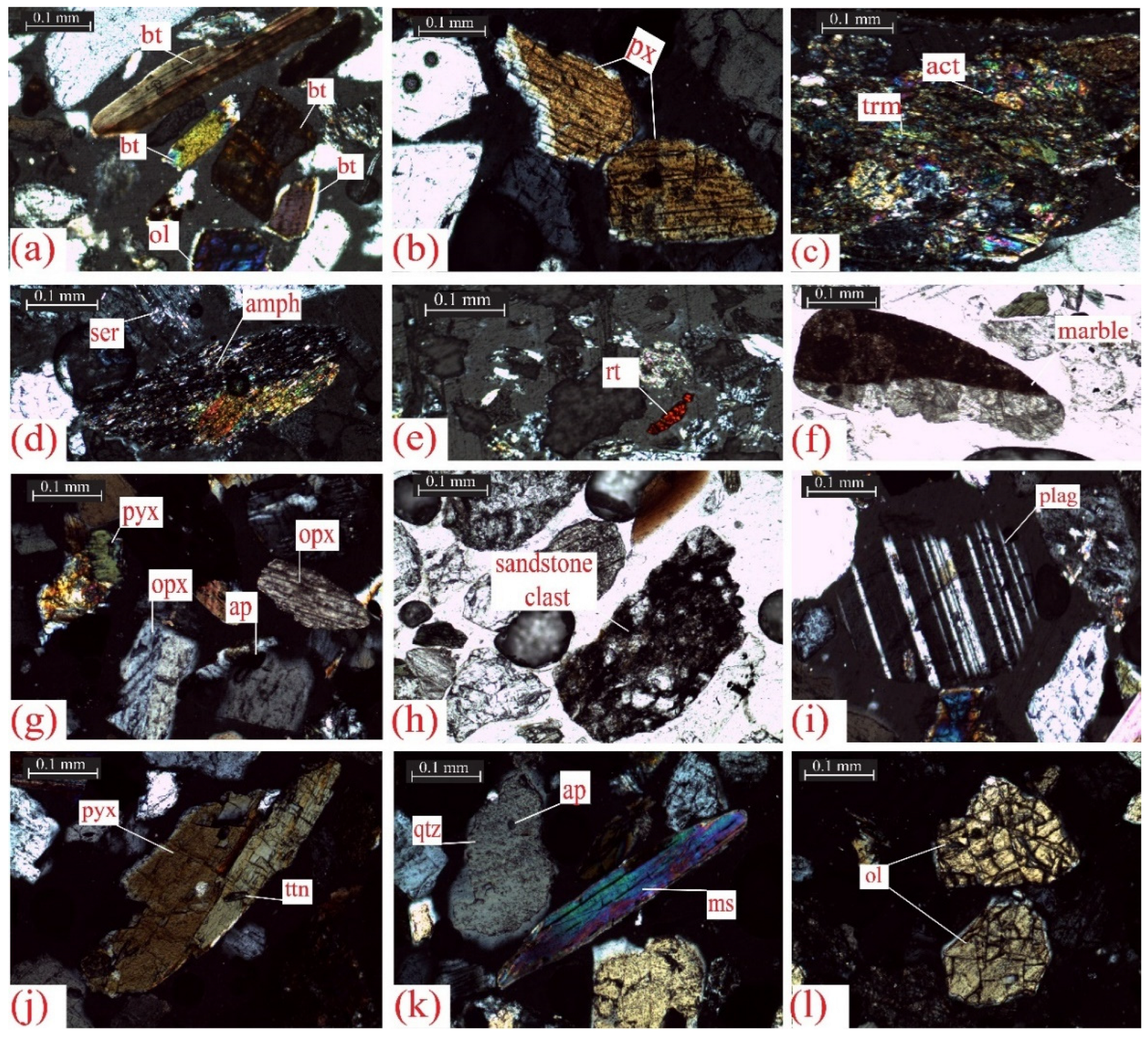
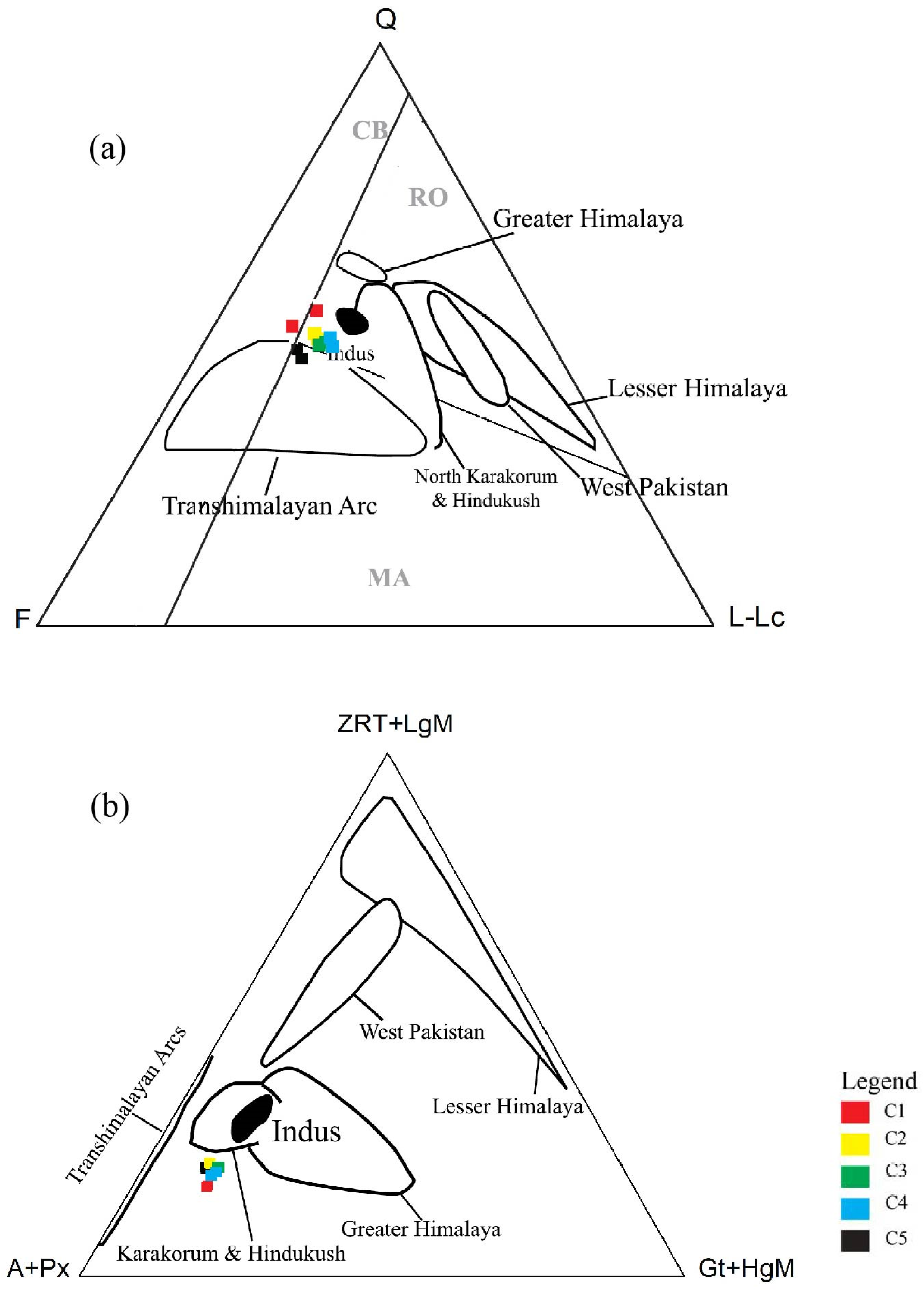
4.1. Petrographic Study
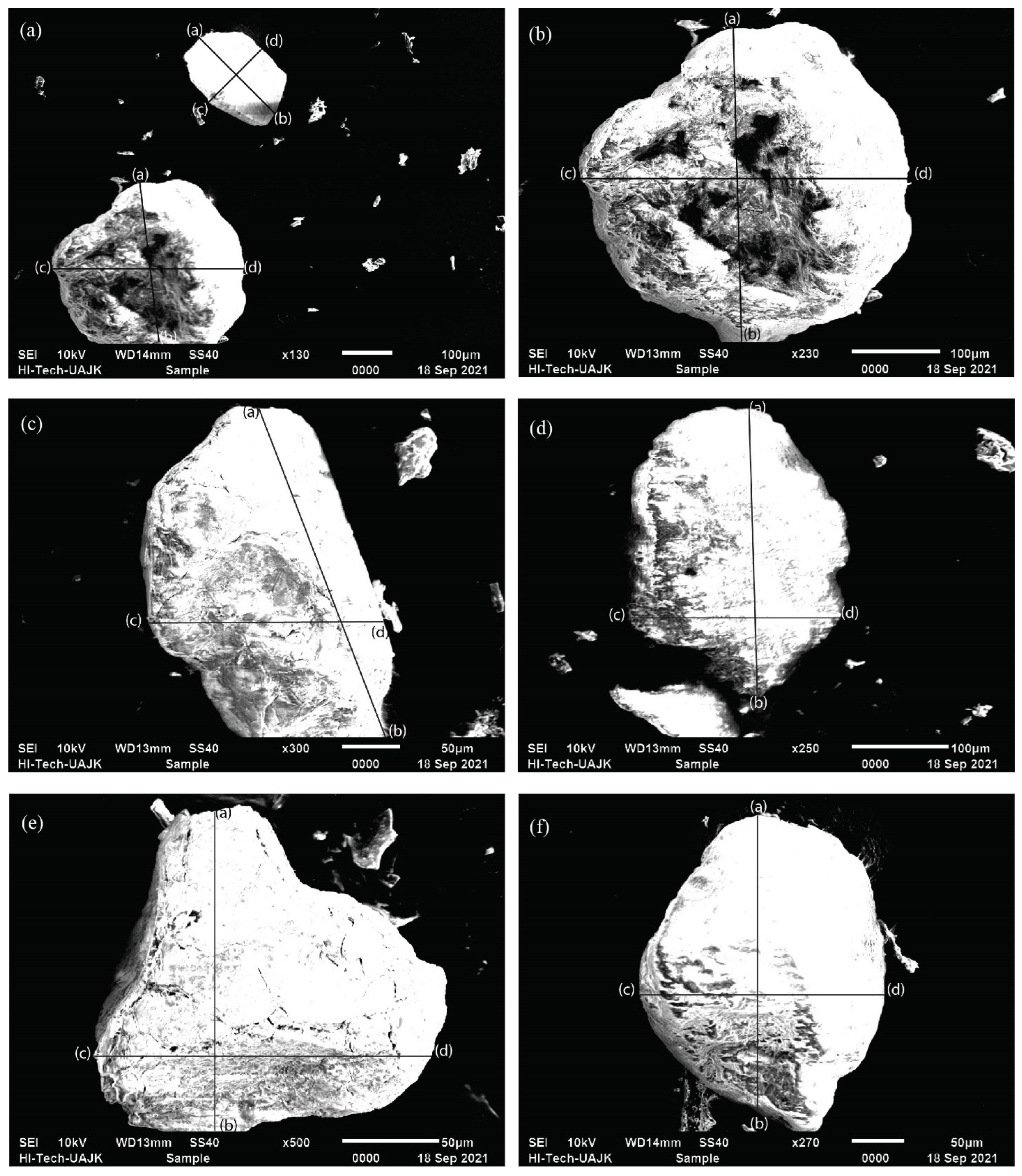
4.2. Morphological Features of the Alluvial Gold
4.3. Geochemical Analysis
4.3.1. Major Element Oxides
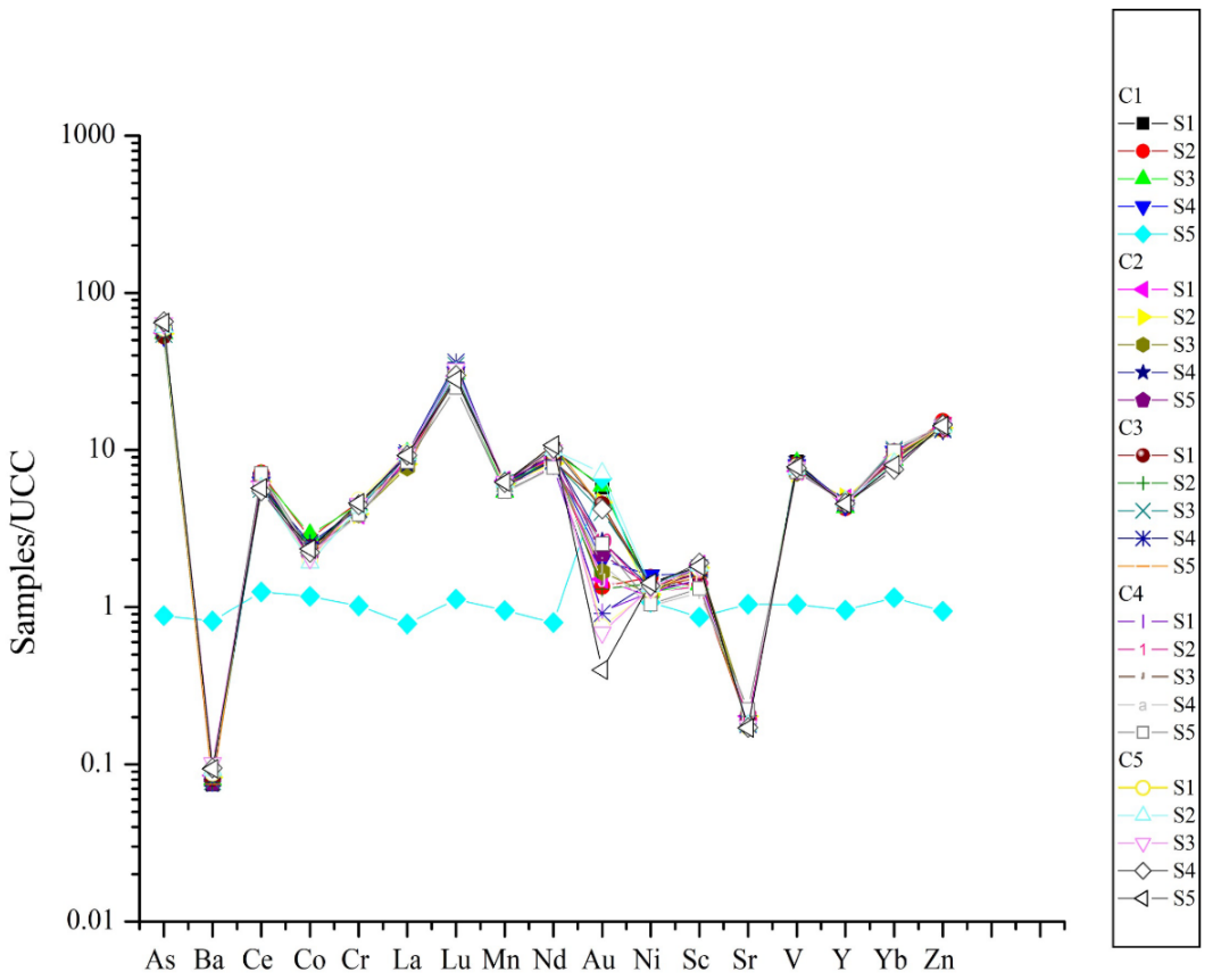
4.3.2. Trace and Rare Earth Elements
4.3.3. Gold Determination in Quaternary Sediments
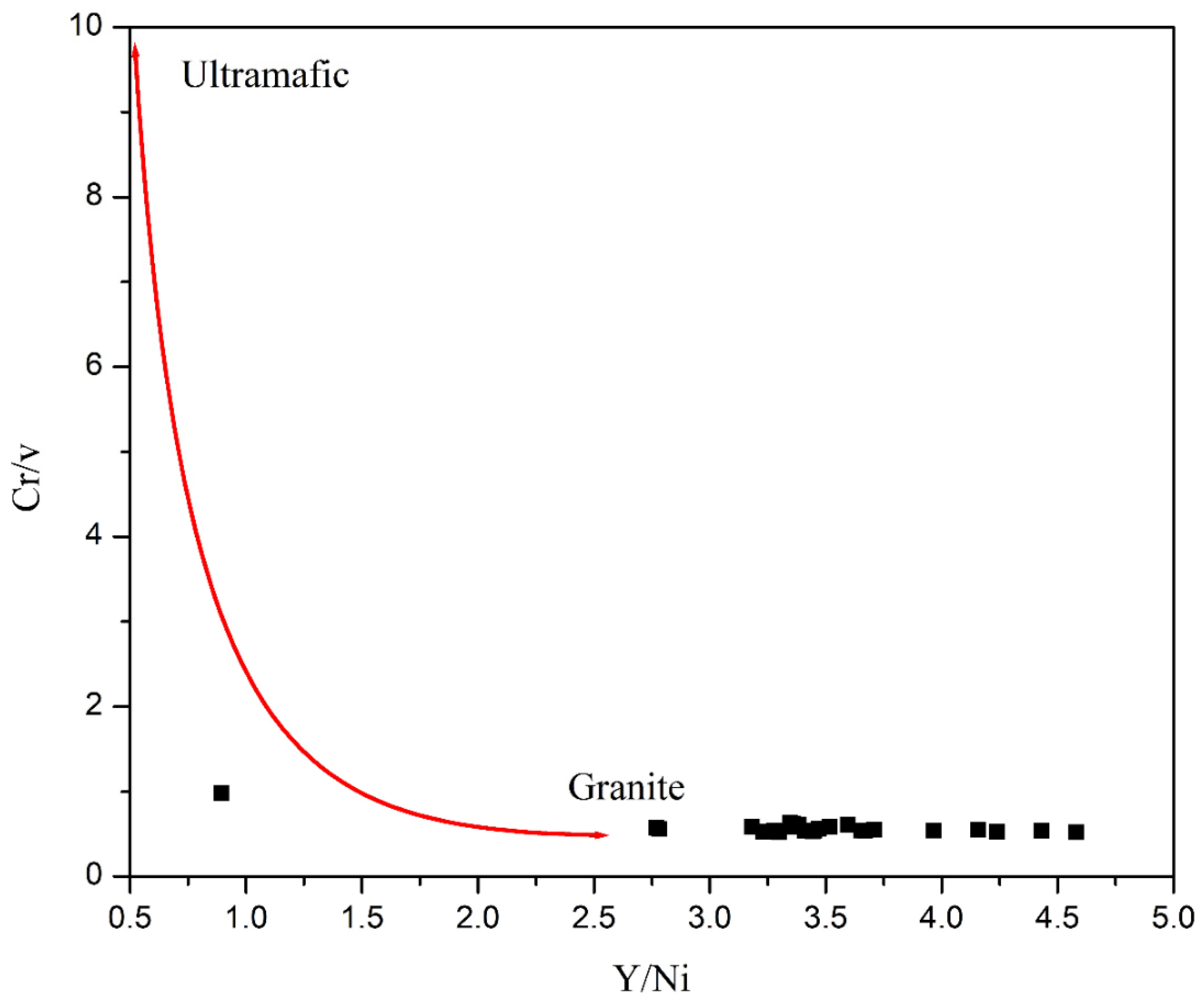
5. Discussions
6. Conclusions
Author Contributions
Funding
Data Availability Statement
Acknowledgments
Conflicts of Interest
References
- Kirk, J.; Ruiz, J.; Chesley, J.; Titley, S. The Origin of Gold in South Africa. Am. Sci. 2003, 91, 534. [Google Scholar] [CrossRef]
- Pan, B.; Pang, H.; Gao, H.; Garzanti, E.; Zou, Y.; Liu, X.; Li, F.; Jia, Y. Heavy-mineral analysis and provenance of Yellow River sediments around the China Loess Plateau. J. Asian Earth Sci. 2016, 127, 1–11. [Google Scholar] [CrossRef]
- Vikent’eva, O.V.; Prokofiev, V.Y.; Gamyanin, G.N.; Goryachev, N.A.; Bortnikov, N.S. Intrusion-related gold-bismuth deposits of North-East Russia: PTX parameters and sources of hydrothermal fluids. Ore Geol. Rev. 2018, 102, 240–259. [Google Scholar] [CrossRef]
- Nikiforova, Z. Criteria for Determining the Genesis of Placers and Their Different Sources Based on the Morphological Features of Placer Gold. Minerals 2021, 11, 381. [Google Scholar] [CrossRef]
- Ali, A.; Rehman, K.; Tayyab, O.; Zaman, T.; Jameel, M.; Khan, A.; Ahmad, R.; Irfan, M. Exploring Placer Gold Deposits through Integrated Geophysical and Geochemical Techniques at the Confluence of the Indus and Kabul Rivers, NW Pakistan. Acta Geol. Sin.-Engl. Ed. 2020, 94, 1440–1450. [Google Scholar] [CrossRef]
- Prasad, U. Economic Geology Economic Mineral Deposits, 2nd ed.; CBS Publishers & Distributors Private ltd: Delhi, India, 2012. [Google Scholar]
- Dill, H.G. Gems and placers—A genetic relationship par excellence. Minerals 2018, 8, 470. [Google Scholar]
- Rashid, N.; Zafar, M.; Ahmad, M.; Malik, K.; Shah, S.N.; Sultana, S.; Zahid, N.; Noshad, Q.; Siddiq, Z. Use of scanning electron microscopy to analyze sculpturing pattern and internal features of pollen grain wall in some members of Astragaleae (subfamily: Papilionoidae). Microsc. Res. Tech. 2022, 85, 1631–1642. [Google Scholar] [CrossRef]
- Alam, M.; Li, S.R.; Santosh, M.; Yuan, M.W. Morphology and chemistry of placer gold in the Bagrote and Dainter streams, northern Pakistan: Implications for provenance and exploration. Geol. J. 2019, 54, 1672–1687. [Google Scholar] [CrossRef]
- Ali, L.; Chapman, R.; Farhan, M.; Shah, M.T.; Khattak, S.A.; Ali, A. Exploration Methodology Using Morphology and Alloy Composition of Alluvial Gold: A Case Study from Quaternary Deposits of the Nowshera District, Khyber Pakhtunkhwa, Pakistan. Min. Metall. Explor. 2021, 38, 367–377. [Google Scholar]
- Lalomov, A.; Chefranov, R.; Naumov, V.; Naumova, O.; LeBarge, W.; Dilly, R. Typomorphic features of placer gold of Vagran cluster (the Northern Urals) and search indicators for primary bedrock gold deposits. Ore Geol. Rev. 2017, 85, 321–335. [Google Scholar] [CrossRef]
- Youngson, J.; Craw, D. Gold nugget growth during tectonically induced sedimentary recycling, Otago, New Zealand. Sediment. Geol. 1993, 84, 71–88. [Google Scholar] [CrossRef]
- Omang, B.; Suh, C.; Lehmann, B.; Vishiti, A.; Chombong, N.; Fon, A.; Egbe, J.; Shemang, E. Microchemical signature of alluvial gold from two contrasting terrains in Cameroon. J. Afr. Earth Sci. 2015, 112, 1–14. [Google Scholar] [CrossRef]
- Ali, L.; Moon, C.J.; Williamson, B.J.; Shah, M.T.; Khattak, S.A. A GIS-based stream sediment geochemical model for gold and base metal exploration in remote areas of northern Pakistan. Arab. J. Geosci. 2015, 8, 5081–5093. [Google Scholar] [CrossRef]
- Miandad, S.; Shah, M.T.; Khan, S.D.; Ahmad, L. Investigation for gold and base metals mineralization and petrochemical characteristics of the rocks of upper parts of Bagrot valley, Gilgit-Baltistan, Pakistan. J. Himal. Earth Sci. 2014, 47, 29. [Google Scholar]
- Shah, M.T.; Khan, S.D.; Ahmad, L. Investigation of gold and base metals mineralization and the petrochemical studies of the associated host rocks, Shagari Bala area, Skardu Gilgit-Baltistan, Pakistan. J. Himal. Earth Sci. 2015, 48, 26–40. [Google Scholar]
- Sheikh, L.; Shah, M.T.; Khan, S.D.; Ahmad, L. Investigation for gold and base metals mineralization and petrochemical characteristics of the rocks of Golo Das and surrounding areas, District Ghizar, Gilgit-Baltistan, Pakistan. J. Himal. Earth Sci. 2014, 47, 15–27. [Google Scholar]
- Ghazi, S.; Ali, S.H.; Sahraeyan, M.; Hanif, T. An overview of tectonosedimentary framework of the Salt Range, northwestern Himalayan fold and thrust belt, Pakistan. Arab. J. Geosci. 2015, 8, 1635–1651. [Google Scholar] [CrossRef]
- Bibi, M.; Wagreich, M.; Iqbal, S.; Jan, I.U. Regional sediment sources versus the Indus River system: The Plio-Pleistocene of the Peshawar basin (NW-Pakistan). Sediment. Geol. 2019, 389, 26–41. [Google Scholar] [CrossRef]
- Bibi, M.; Wagreich, M.; Iqbal, S.; Gier, S.; Jan, I.U. Sedimentation and glaciations during the Pleistocene: Palaeoclimate reconstruction in the Peshawar Basin, Pakistan. Geol. J. 2020, 55, 671–693. [Google Scholar] [CrossRef]
- Ghazi, S.; Ali, S.H.; Shahzad, T.; Ahmed, N.; Khalid, P.; Akram, S.; Ali, S.; Sami, J. Sedimentary, structural and salt tectonic evolution of Karoli-Nilawahan area, Central Salt Range and its impact for the Potwar Province. Himal. Geol. 2020, 41, 145–156. [Google Scholar]
- Searle, M.P.; Treloar, P.J. London, Special Publications. Introduction to Himalayan tectonics: A modern synthesis. Geol. Soc. London Spéc. Publ. 2019, 483, 1–17. [Google Scholar] [CrossRef]
- Yasin, Q.; Baklouti, S.; Khalid, P.; Ali, S.H.; Boateng, C.D.; Du, Q. Evaluation of shale gas reservoirs in complex structural enclosures: A case study from Patala Formation in the Kohat-Potwar Plateau, Pakistan. J. Pet. Sci. Eng. 2021, 198, 108225. [Google Scholar] [CrossRef]
- Javed, A.; Wahid, A.; Mughal, M.S.; Khan, M.S.; Qammar, R.S.; Ali, S.H.; Siddiqui, N.A.; Iqbal, M.A. Geological and petrographic investigations of the Miocene Molasse deposits in Sub-Himalayas, District Sudhnati, Pakistan. Arab. J. Geosci. 2021, 14, 1517. [Google Scholar] [CrossRef]
- Ashraf, M.; Dawood, H. Geology of Acid and Alkalic Minor Bodies Associated with Granitic and Alkalic Complexes of Malakand Division. Geol. Bull. Punjab Univ. 2010, 45, 49–68. [Google Scholar]
- Ali, L.; Ahmad, S.; Khattak, S.A.; Anjum, N.; Waseem, M.; Ali, A. Economic Evaluation of Placer Gold Along River Indus From Ghazi to Kund, Khyber Pakhtunkhwa, Pakistan: Implications for Commercial Scale Pilot Plant. Int. J. Econ. Environ. Geol. 2019, 10, 129–134. [Google Scholar]
- Wahid, A.; Rauf, A.; Ali, S.H.; Khan, J.; Iqbal, M.A.; Haseeb, A. Impact of complex tectonics on the development of geo-pressured zones: A case study from petroliferous Sub-Himalayan Basin, Pakistan. Geopersia 2021, 12, 89–106. [Google Scholar]
- Burbank, D.W.; Tahirkheli, R.A.K. The magnetostratigraphy, fission-track dating, and stratigraphic evolution of the Peshawar intermontane basin, northern Pakistan. Geol. Soc. Am. Bull. 1985, 96, 539–552. [Google Scholar] [CrossRef]
- Mallik, T.; Vasudevan, V.; Verghese, P.; Machado, T. The black sand placer deposits of Kerala beach, southwest India. Mar. Geol. 1987, 77, 129–150. [Google Scholar] [CrossRef]
- Evans, A.M. Ore Geology and Industrial Minerals: An Introduction; John Wiley & Sons: Hoboken, NJ, USA, 2009. [Google Scholar]
- Ahmed, N.; Ali, S.H.; Ahmad, M.; Khalid, P.; Ahmad, B.; Akram, M.S.; Farooq, S.; Din, Z.U. Subsurface Structural Investigation Based on Seismic Data of the North-Eastern Potwar Basin, Pakistan. Indian J. Geo-Mar. Sci. 2022, 49, 1258–1268. [Google Scholar]
- Zada, K.; Arif, M.; Sajid, M.J.G. Controls and Implications of Geo-Technical Variation in Quartzose Rocks from Peshawar Basin, North-Western Pakistan. Geomaterials 2015, 5, 85. [Google Scholar] [CrossRef]
- Hussain, A.; Pogue, K.; Khan, S.R.; Ahmad, I. Paleozoic stratigraphy of the Peshawar basin, Pakistan. Geol. Bull. Univ. Peshawar 1991, 24, 85–97. [Google Scholar]
- Cornwell, K. Quaternary break-out flood sediments in the Peshawar basin of northern Pakistan. Geomorphology 1998, 25, 225–248. [Google Scholar] [CrossRef]
- Ali, L.; Williamson, B.J.; Moon, C.J.; Shah, M.T.; Khattak, S.A. Distribution of gold in different size fractions of stream sediments as a guide to bedrock gold mineralisation along the Shyok Suture Zone and adjacent areas of the Kohistan Island Arc, Pakistan. Arab. J. Geosci. 2015, 8, 2227–2235. [Google Scholar] [CrossRef]
- Thompson, A.C.; Vaughan, D. X-ray Data Booklet; Lawrence Berkeley National Laboratory, University of California Berkeley: Berkeley, CA, USA, 2001; Volume 8. [Google Scholar]
- Hubert, A.E.; Chao, T.T. Determination of gold, indium, tellurium and thallium in the same sample digest of geological materials by atomic-absorption spectroscopy and two-step solvent extraction. Talanta 1985, 32, 568–570. [Google Scholar] [CrossRef]
- Dobrowolski, R.; Mróz, A.; Dąbrowska, M.; Olszański, P. Solid sampling high-resolution continuum source graphite furnace atomic absorption spectrometry for gold determination in geological samples after preconcentration onto carbon nanotubes. Spectrochim. Acta Part B At. Spectrosc. 2017, 132, 13–18. [Google Scholar] [CrossRef]
- Moghaddam, F.H.; Taher, M.A.; Behzadi, M.; Naghizadeh, M. Modified carbon nanotubes as a sorbent for solid-phase extraction of gold, and its determination by graphite furnace atomic absorption spectrometry. Microchim. Acta 2015, 182, 2123–2129. [Google Scholar] [CrossRef]
- Santosh, M.; Omana, P.K. Very high purity gold form lateritic weathering profiles of Nilambur, southern India. Geology 1991, 19, 746–749. [Google Scholar] [CrossRef]
- McLennan, S.M. Relationships between the trace element composition of sedimentary rocks and upper continental crust. Geochem. Geophys. Geosystems 2001, 2. [Google Scholar] [CrossRef]
- Mongelli, G.; Critelli, S.; Perri, F.; Sonnino, M.; Perrone, V. Sedimentary recycling, provenance and paleoweathering from chemistry and mineralogy of Mesozoic continental redbed mudrocks, Peloritani Mountains, Southern Italy. Geochem. J. 2006, 40, 197–209. [Google Scholar] [CrossRef]
- Baurens, S. Valuation of metals and mining companies. In Immobilienwirtschaft Aktuell; University of Zurich: Zurich, Switzerland, 2010. [Google Scholar]
- Garzanti, E.; Vezzoli, G.; Andò, S.; Paparella, P.; Clift, P.D. Petrology of Indus River sands: A key to interpret erosion h4istory of the Western Himalayan Syntaxis. Earth Planet. Sci. Lett. 2005, 229, 287–302. [Google Scholar] [CrossRef]
- Fuanya, C.; Bolarinwa, A.T.; Kankeu, B.; Yongue, R.F.; Ngatcha, R.B.; Tangko, T.E. Morphological and chemical assessment of alluvial gold grains from Ako’ozam and Njabilobe, southwestern Cameroon. J. Afr. Earth Sci. 2019, 154, 111–119. [Google Scholar] [CrossRef]
- Yang, X.-M.; Lentz, D.R.; Chi, G.; Thorne, K.G. Geochemical characteristics of gold-related granitoids in southwestern New Brunswick, Canada. Lithos 2008, 104, 355–377. [Google Scholar] [CrossRef]
- Dunn, S.C.; Bjorn, P.; Rozendaal, A.; Taljaard, R. Secondary gold mineralization in the Amani placer gold deposit, Tanzania. Ore Geol. Rev. 2019, 107, 87–107. [Google Scholar] [CrossRef]


| Mineralogical Composition | Clusters | |||||||||||||||||||||||||
|---|---|---|---|---|---|---|---|---|---|---|---|---|---|---|---|---|---|---|---|---|---|---|---|---|---|---|
| C1 | C2 | C3 | C4 | C5 | ||||||||||||||||||||||
| S1 | S2 | S3 | S4 | S5 | S1 | S2 | S3 | S4 | S5 | S1 | S2 | S3 | S4 | S5 | S1 | S2 | S3 | S4 | S5 | S1 | S2 | S3 | S4 | S5 | ||
| Quartz | Polycrystalline | 3 | 5 | 4 | 5 | 3 | 12 | 10 | 11 | 13 | 13 | 12 | 13 | 11 | 14 | 13 | 9 | 11 | 10 | 12 | 11 | 11 | 12 | 14 | 11 | 14 |
| Monocrystalline | 41 | 40 | 42 | 43 | 45 | 30 | 32 | 35 | 35 | 31 | 33 | 35 | 37 | 35 | 34 | 31 | 30 | 34 | 37 | 36 | 35 | 34 | 31 | 30 | 35 | |
| Feldspar | 30 | 32 | 35 | 33 | 36 | 31 | 28 | 25 | 24 | 26 | 33 | 29 | 31 | 30 | 32 | 33 | 35 | 36 | 34 | 37 | 33 | 32 | 30 | 35 | 30 | |
| Rocks Fragments | Igneous | 7 | 6 | 5 | 4 | 3 | 6 | 7 | 8 | 7 | 8 | 3 | 5 | 5 | 4 | 4 | 5 | 4 | 4 | 2 | 4 | 5 | 6 | 8 | 4 | 4 |
| Metamorphic | 6 | 4 | 3 | 5 | 4 | 4 | 6 | 4 | 8 | 7 | 5 | 4 | 3 | 5 | 3 | 4 | 6 | 3 | 5 | 4 | 4 | 3 | 5 | 6 | 5 | |
| Sedimentary | 3 | 5 | 3 | 4 | 4 | 5 | 6 | 5 | 3 | 4 | 2 | 3 | 3 | 2 | 5 | 3 | 4 | 5 | 3 | 4 | 4 | 5 | 7 | 4 | 2 | |
| Accessory Minerals | 4 | 4 | 6 | 5 | 3 | 10 | 9 | 8 | 7 | 7 | 9 | 8 | 5 | 6 | 4 | 7 | 5 | 4 | 3 | 2 | 6 | 4 | 3 | 5 | 6 | |
| Opaque Minerals | 3 | 4 | 2 | 1 | 2 | 2 | 2 | 4 | 3 | 4 | 2 | 3 | 5 | 4 | 5 | 3 | 5 | 4 | 4 | 2 | 2 | 4 | 2 | 5 | 4 | |
| Total | 100 | 100 | 100 | 100 | 100 | 100 | 100 | 100 | 100 | 100 | 100 | 100 | 100 | 100 | 100 | 100 | 100 | 100 | 100 | 100 | 100 | 100 | 100 | 100 | 100 | |
| Clusters | HMC% | ZTR | A | Px | O + S | LgM | Gt | HgM | Total |
|---|---|---|---|---|---|---|---|---|---|
| C1 | 3 | 3 | 53 | 15 | 5 | 13 | 8 | 3 | 100 |
| C2 | 2 | 4 | 52 | 16 | 4 | 15 | 7 | 2 | 100 |
| C3 | 2 | 2 | 54 | 12 | 6 | 17 | 6 | 3 | 100 |
| C4 | 3 | 2 | 50 | 13 | 7 | 17 | 7 | 4 | 100 |
| C5 | 2 | 3 | 52 | 10 | 10 | 16 | 6 | 3 | 100 |
| Cluster | Sample | Length L (Μm) | Width B (Μm) | Thickness T (Μm) | Flatness Index (FI) |
|---|---|---|---|---|---|
| C1 | S1 | 214 | 143 | 24.665 | 7.2 |
| S2 | 180 | 110 | 18.8 | 7.7 | |
| S3 | 349 | 361 | 28.782 | 12.33 | |
| C2 | S1 | 344 | 354 | 16.24 | 21.49 |
| S2 | 213 | 234 | 14.5 | 4.8 | |
| S3 | 309 | 205 | 30.289 | 8.48 | |
| C3 | S1 | 296 | 245 | 11.773 | 21.829 |
| S2 | 301 | 206 | 13.97 | 11.20 | |
| S3 | 818 | 606 | 25 | 28.48 | |
| C4 | S1 | 312 | 221 | 13.76 | 19.36 |
| S2 | 421 | 167 | 9.42 | 31.21 | |
| S3 | 251 | 144 | 11.65 | 16.95 | |
| C5 | S1 | 137 | 119 | 7.43 | 17.22 |
| S2 | 371 | 287 | 11.65 | 28.24 | |
| S3 | 290 | 198 | 13 | 18.76 |
| Oxides | Cluster Name | |||||||||
|---|---|---|---|---|---|---|---|---|---|---|
| C1 | C2 | C3 | C4 | C5 | ||||||
| Sample Names | ||||||||||
| S1 | S2 | S1 | S2 | S1 | S2 | S1 | S2 | S1 | S2 | |
| SiO2 | 46.9 | 44.9 | 45.94 | 46.9 | 44.91 | 51.04 | 54.55 | 51.12 | 53.95 | 45.84 |
| Fe2O3 | 46.9 | 42.47 | 43.95 | 45.9 | 42.67 | 23.97 | 23.97 | 24.20 | 25.72 | 43.96 |
| Al2O3 | 12.6 | 14.64 | 13.62 | 12.6 | 14.24 | 11.74 | 10.98 | 12.23 | 11.82 | 13.61 |
| CaO | 6.1 | 5.19 | 7.12 | 6.11 | 8.19 | 6.52 | 6.52 | 7.43 | 8.21 | 7.22 |
| TiO2 | 4.4 | 3.50 | 4.01 | 4.42 | 3.53 | 4.36 | 4.36 | 5.54 | 8.68 | 4.01 |
| K2O | 0.8 | 0.56 | 0.80 | 0.84 | 0.46 | 1.21 | 1.22 | 2.00 | 1.10 | 0.82 |
| MnO | 0.61 | 0.70 | 0.61 | 0.61 | 0.79 | 0.39 | 0.44 | 0.50 | 0.45 | 0.64 |
| ZrO2 | 0.41 | 0.42 | 0.42 | 0.41 | 0.48 | 0.29 | 0.45 | 0.39 | 0.78 | 0.45 |
| V2O5 | 0.16 | 0.15 | 0.18 | 0.19 | 0.13 | 0.20 | 0.11 | 0.10 | 0.87 | 0.18 |
| Cr2O3 | 0.14 | 0.19 | 0.14 | 0.12 | 0.12 | 0.17 | 0.19 | 0.19 | 0.16 | 0.15 |
| ThO2 | 0.03 | 0.01 | 0.01 | 0.02 | 0.01 | - | 0.00 | - | - | 0.00 |
| Y2O3 | 0.02 | 0.01 | 0.02 | 0.02 | 0.01 | 0.01 | 0.01 | 0.00 | 0.02 | 0.03 |
| CuO | 0.01 | 0.06 | 0.01 | 0.01 | 0.06 | 0.01 | 0.01 | 0.05 | 0.01 | 0.02 |
| SrO | 0.01 | 0.01 | 0.01 | 0.01 | 0.02 | 0.02 | 0.01 | 0.02 | 0.00 | 0.01 |
| ZnO | 0.01 | 0.01 | 0.02 | 0.01 | 0.00 | 0.01 | 0.01 | 0.01 | 0.03 | 0.02 |
| NbO | 0.01 | 0.01 | 0.02 | 0.00 | 0.00 | 0.00 | 0.00 | 0.01 | 0.00 | 0.04 |
| Clusters | C1 | C2 | C3 | C4 | C5 | ||||||||||||||||||||
|---|---|---|---|---|---|---|---|---|---|---|---|---|---|---|---|---|---|---|---|---|---|---|---|---|---|
| Elements | S-1 | S-2 | S-3 | S-4 | S-5 | S-1 | S-2 | S-3 | S-4 | S-5 | S-1 | S-2 | S-3 | S-4 | S-5 | S-1 | S-2 | S-3 | S-4 | S-5 | S-1 | S-2 | S-3 | S-4 | S-5 |
| Au (ug/g) | 10 | 7.8 | 8.0 | 11 | 13 | 9.8 | 6.9 | 7 | 4.3 | 5.68 | 9.80 | 5.87 | 5 | 3.67 | 3.890 | 4.00 | 2.4 | 3.90 | 2.76 | 4.72 | 1 | 5.32 | 4.90 | 2.90 | 1.68 |
| As (ug/g) | 85 | 85 | 82 | 80 | 85 | 83 | 82 | 84 | 85 | 88.9 | 80.0 | 80.1 | 82 | 88.1 | 85.32 | 90.1 | 90 | 89.0 | 92.6 | 90.1 | 89 | 90.9 | 95.8 | 98.30 | 96.70 |
| Ba (ug/g) | 41 | 42 | 43 | 43 | 42 | 46 | 45 | 44 | 41 | 42.1 | 44.3 | 42.3 | 43 | 45.1 | 41.29 | 50.0 | 47 | 49.5 | 48.7 | 49.5 | 48 | 50.7 | 55.9 | 52.30 | 51.54 |
| Ce (ug/g) | 438 | 458 | 438 | 397 | 458 | 403 | 40 | 402 | 438 | 428 | 387 | 381 | 361 | 380 | 438.1 | 432 | 453 | 444 | 438 | 453 | 369 | 365 | 370 | 350.5 | 366 |
| Co (ug/g) | 58 | 68 | 72 | 60 | 68 | 59 | 59 | 56 | 53 | 51.2 | 60.1 | 59.8 | 61 | 63.7 | 53.35 | 56.4 | 56 | 54.7 | 53.6 | 56.7 | 49 | 47.8 | 51.2 | 55.65 | 58.54 |
| Cr (ug/g) | 372 | 388 | 372 | 369 | 388 | 321 | 324 | 324 | 372 | 382 | 354 | 358 | 349 | 351 | 382 | 323 | 319 | 322 | 318 | 322 | 398 | 355 | 375 | 371.30 | 380.87 |
| La (ug/g) | 286 | 246 | 286 | 288 | 216 | 263 | 243 | 233 | 245 | 265 | 278 | 282 | 277 | 286 | 235 | 276 | 271 | 273 | 250.5 | 252.3 | 289 | 280 | 282 | 277.6 | 276.4 |
| Lu (ug/g) | 9.8 | 10 | 9 | 10 | 10 | 9 | 9 | 9 | 9.5 | 9.98 | 10.0 | 9.80 | 11 | 11.5 | 9.870 | 8.92 | 8.9 | 9.06 | 9.06 | 7.99 | 9.76 | 10.0 | 10 | 9.550 | 8.990 |
| Mn (ug/g) | 3444 | 3564 | 3246 | 3674 | 3565 | 3827 | 3628 | 3598 | 3664 | 3704 | 3674 | 3682 | 3699 | 3490 | 3674 | 3564 | 355 | 3499 | 3199 | 3276 | 3789 | 3770 | 3754 | 3720 | 3749 |
| Nd (ug/g) | 262 | 232 | 252 | 221 | 22 | 232 | 212 | 220 | 242 | 244 | 221 | 225 | 221 | 225 | 282 | 202 | 202 | 205 | 199 | 200 | 254 | 260 | 258 | 265.6 | 278.8 |
| Cluster | Sample Name | GOLD (ppm) | Average (ppm) |
|---|---|---|---|
| C1 | S1 | 11.4 | 10.406 |
| S2 | 9.8 | ||
| S3 | 7.58 | ||
| S4 | 10.23 | ||
| S5 | 13.02 | ||
| C2 | S1 | 10.2 | 6.93 |
| S2 | 8.9 | ||
| S3 | 7.3 | ||
| S4 | 5.04 | ||
| S5 | 3.21 | ||
| C3 | S1 | 8.01 | 4.982 |
| S2 | 6.2 | ||
| S3 | 3.4 | ||
| S4 | 4.9 | ||
| S5 | 2.4 | ||
| C4 | S1 | 3.9 | 2.452 |
| S2 | 1.34 | ||
| S3 | 1.9 | ||
| S4 | 2.02 | ||
| S5 | 3.1 | ||
| C5 | S1 | 0.34 | 2.768 |
| S2 | 5.93 | ||
| S3 | 1.34 | ||
| S4 | 2.45 | ||
| S5 | 3.78 |
Publisher’s Note: MDPI stays neutral with regard to jurisdictional claims in published maps and institutional affiliations. |
© 2022 by the authors. Licensee MDPI, Basel, Switzerland. This article is an open access article distributed under the terms and conditions of the Creative Commons Attribution (CC BY) license (https://creativecommons.org/licenses/by/4.0/).
Share and Cite
Mateen, A.; Wahid, A.; Janjuhah, H.T.; Mughal, M.S.; Ali, S.H.; Siddiqui, N.A.; Shafique, M.A.; Koumoutsakou, O.; Kontakiotis, G. Petrographic and Geochemical Analysis of Indus Sediments: Implications for Placer Gold Deposits, Peshawar Basin, NW Himalaya, Pakistan. Minerals 2022, 12, 1059. https://doi.org/10.3390/min12081059
Mateen A, Wahid A, Janjuhah HT, Mughal MS, Ali SH, Siddiqui NA, Shafique MA, Koumoutsakou O, Kontakiotis G. Petrographic and Geochemical Analysis of Indus Sediments: Implications for Placer Gold Deposits, Peshawar Basin, NW Himalaya, Pakistan. Minerals. 2022; 12(8):1059. https://doi.org/10.3390/min12081059
Chicago/Turabian StyleMateen, Abdul, Ali Wahid, Hammad Tariq Janjuhah, Muhammad Saleem Mughal, Syed Haroon Ali, Numair Ahmed Siddiqui, Munib Ahmed Shafique, Olga Koumoutsakou, and George Kontakiotis. 2022. "Petrographic and Geochemical Analysis of Indus Sediments: Implications for Placer Gold Deposits, Peshawar Basin, NW Himalaya, Pakistan" Minerals 12, no. 8: 1059. https://doi.org/10.3390/min12081059
APA StyleMateen, A., Wahid, A., Janjuhah, H. T., Mughal, M. S., Ali, S. H., Siddiqui, N. A., Shafique, M. A., Koumoutsakou, O., & Kontakiotis, G. (2022). Petrographic and Geochemical Analysis of Indus Sediments: Implications for Placer Gold Deposits, Peshawar Basin, NW Himalaya, Pakistan. Minerals, 12(8), 1059. https://doi.org/10.3390/min12081059