Hydrologic and Water Quality Modeling of the Pebble Mine Project Pit Lake and Downstream Environment after Mine Closure
Abstract
1. Introduction
2. Materials and Methods
2.1. Hydrologic Modeling
2.2. Geochemical Modeling, Inputs, and Assumptions
- Phase 1: Closure Years 1–15 (open pit backfilling of potentially acid generating (PAG) waste rock and pyritic tailings)
- Phase 2: Closure Years 16–20 (backfilling complete, pit lake filling, no water treatment)
- Phase 3: Closure Years 21–50 (treatment of pit waters; waters from bulk tailings storage facility (TSF), SCPs, treatment plant sludge and reject to pit)
- Phase 4: Closure Years 51–in-perpetuity (maintain pit water levels by pumping, pit water treatment, treatment sludge and reject water to pit).
- The pit lake model prepared for the EIS [23] assumes the pit lake will be stratified in perpetuity, with higher solute waters remaining at the bottom of the pit. As noted in Section 3.1.2., many geologic factors render this a highly unrealistic assumption. We assumed the pit lake will be well-mixed, and the removal of pit water to the treatment plant under managed conditions will not change pit water quality. See discussion in Section 3.1. for pit lake mixing. With a stratified pit and pumping to the treatment plant only from the surface (as proposed in [23] but not specifically proposed in the Project Description (Appendix N) of the FEIS), the lower-solute water would be preferentially removed from the pit over time, potentially increasing remaining concentrations when mixing occurs.
- Ongoing releases of metals, sulfate, and acidity from backfilled PAG waste rock and pyritic tailings are not included. Releases from submerged pit walls are also not included.
- To coordinate with source term estimates in the DEIS (next bullet), pit inflows (cfs) are taken from [24] (Appendix A, Tables A2–A5, Average conditions), as shown in Supplementary Table S3. PHREEQC requires volume percentages for mixing calculations (see Section 3.2.).
- Geochemical source terms (pit inflow concentrations) are taken from [25] (Appendix B1 and B2; 50th percentile values) and [24] (Appendix B1 and B2; 50th percentile values) (Table 1). Bulk TSF supernatant and Bulk TSF Main SCP pH values for Closure Phases 2 and 3 were taken from [24] (Table B1.1), because the DEIS [15] (Appendix K4.18) did not include pH values (“pH was not modeled”).
- Assumptions for water quality were the same as those used in [24] (Table B1.2), including that pit wall source terms were used for direct precipitation, additional snow blow, and pit wall runoff.
- Metals will behave conservatively (i.e., no precipitation or adsorption), as assumed in the DEIS [15,23] for chemical failure modes examined (spills of bulk and pyritic tailings and ore concentrate), which assume that the transport of spilled tailings and resulting downstream metal concentrations are only affected by dilution.
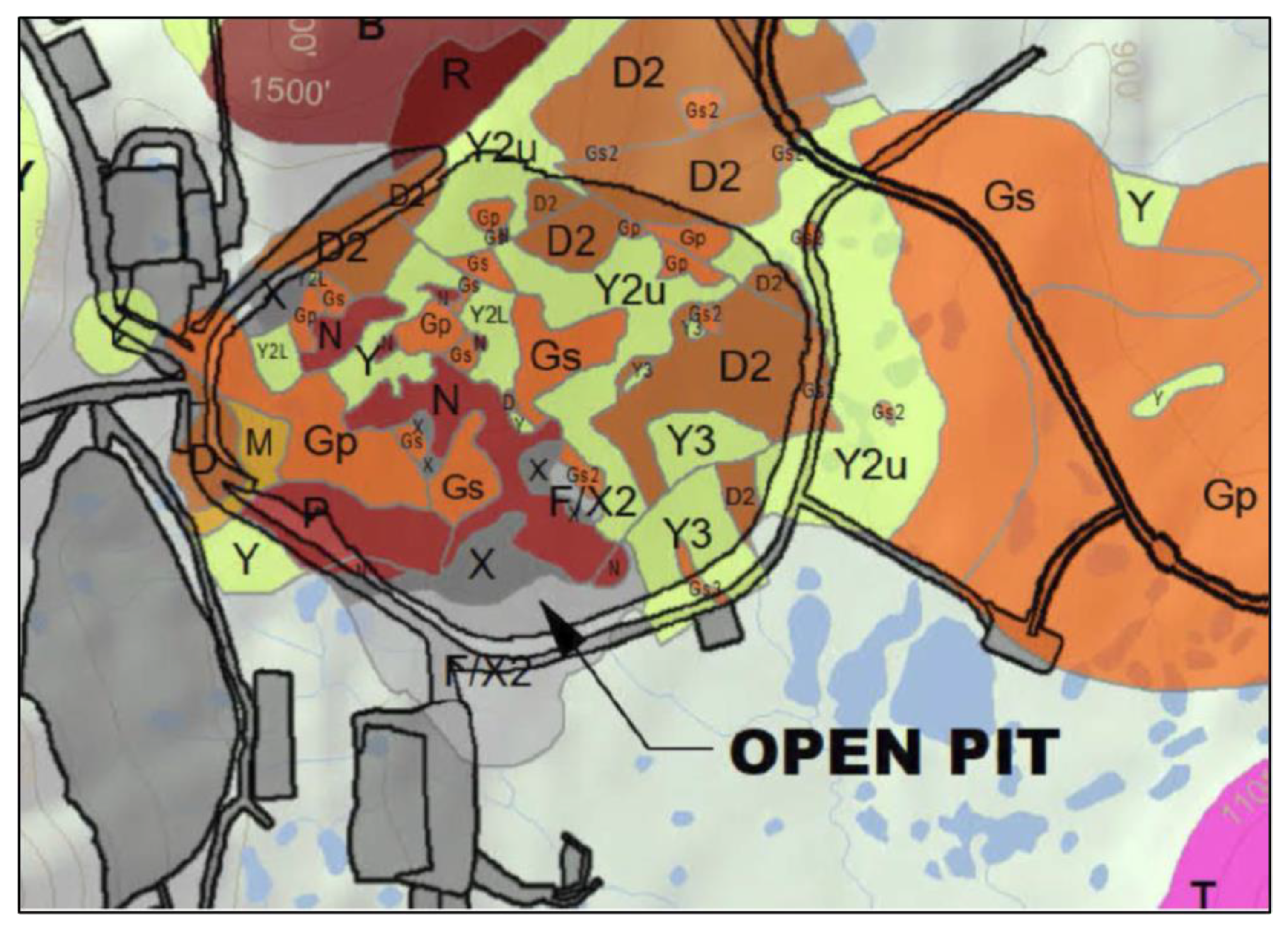
- The geologic map of the pit area was used to estimate the proportion of the pit walls that would generate acidic vs. non-acidic leachate. No estimates of the percentage of Pre-Tertiary and Tertiary rock on the completed pit walls are provided in the DEIS or associated documents, and the one geologic map of the pit rocks (see Section 3.1.) shows no Pre-Tertiary (non-acidic) material in the open pit area. Lorax Environmental [23] assumed all loadings from Pre-Tertiary wall rock would be acidic, and the water quality model for the FEIS assumed that all PAG wall rock would be 100% acidic after only 10 years. In this study, the pit walls were assumed to be 90% Pre-Tertiary acidic and 10% Tertiary non-acidic material. Lower percentages of Pre-Tertiary material were also modeled to evaluate uncertainty in wall rock leachate inputs.
2.3. Surface Water Mixing
3. Results
3.1. Conceptual Hydrogeologic Model Assumptions and Alternatives
3.1.1. Potential Pit Inflows and Outflows
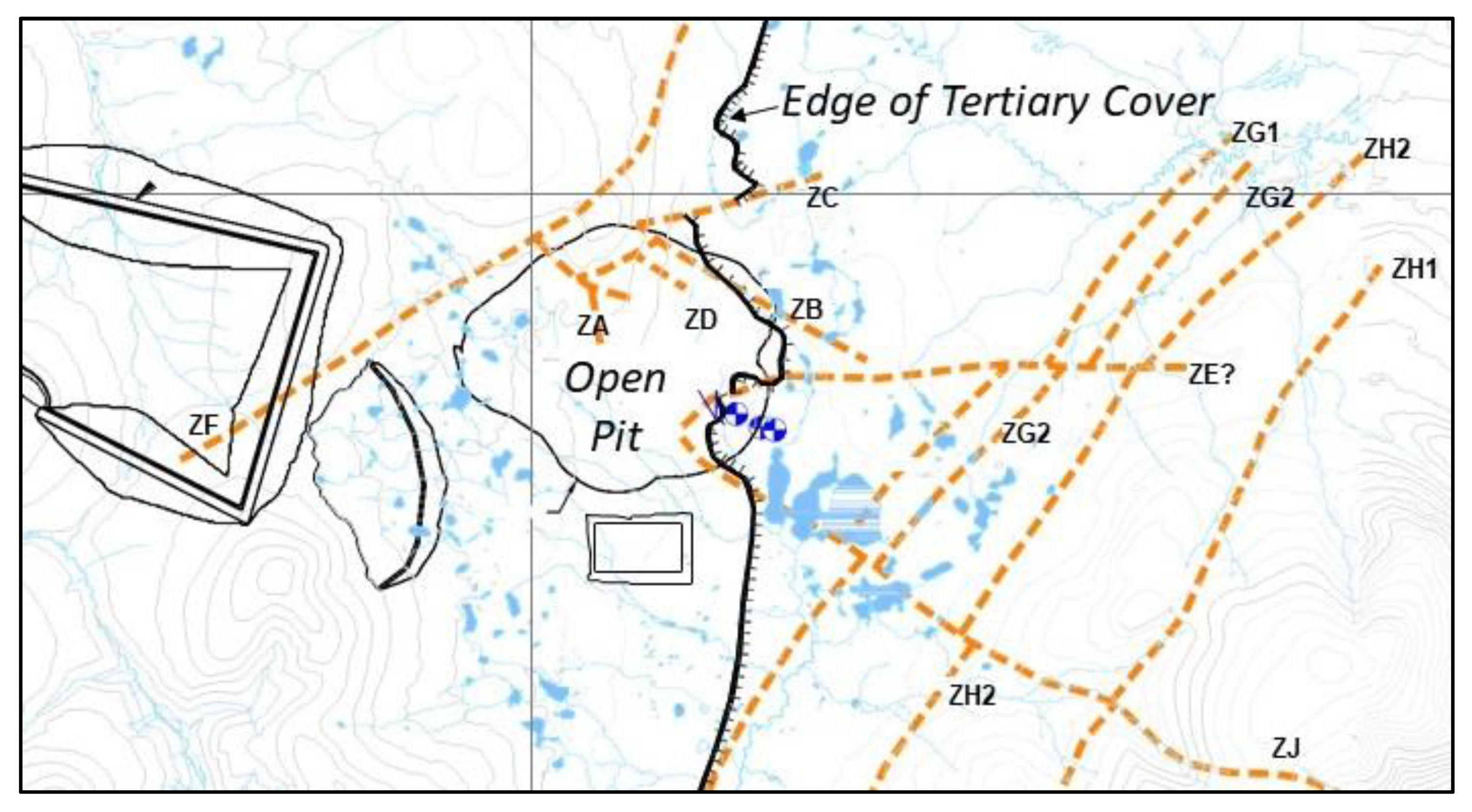
3.1.2. Pit Lake Stratification, Pit Wall Stability, and Water Quality Implications
3.1.3. Pit Wall Leaching and Pit Water Quality
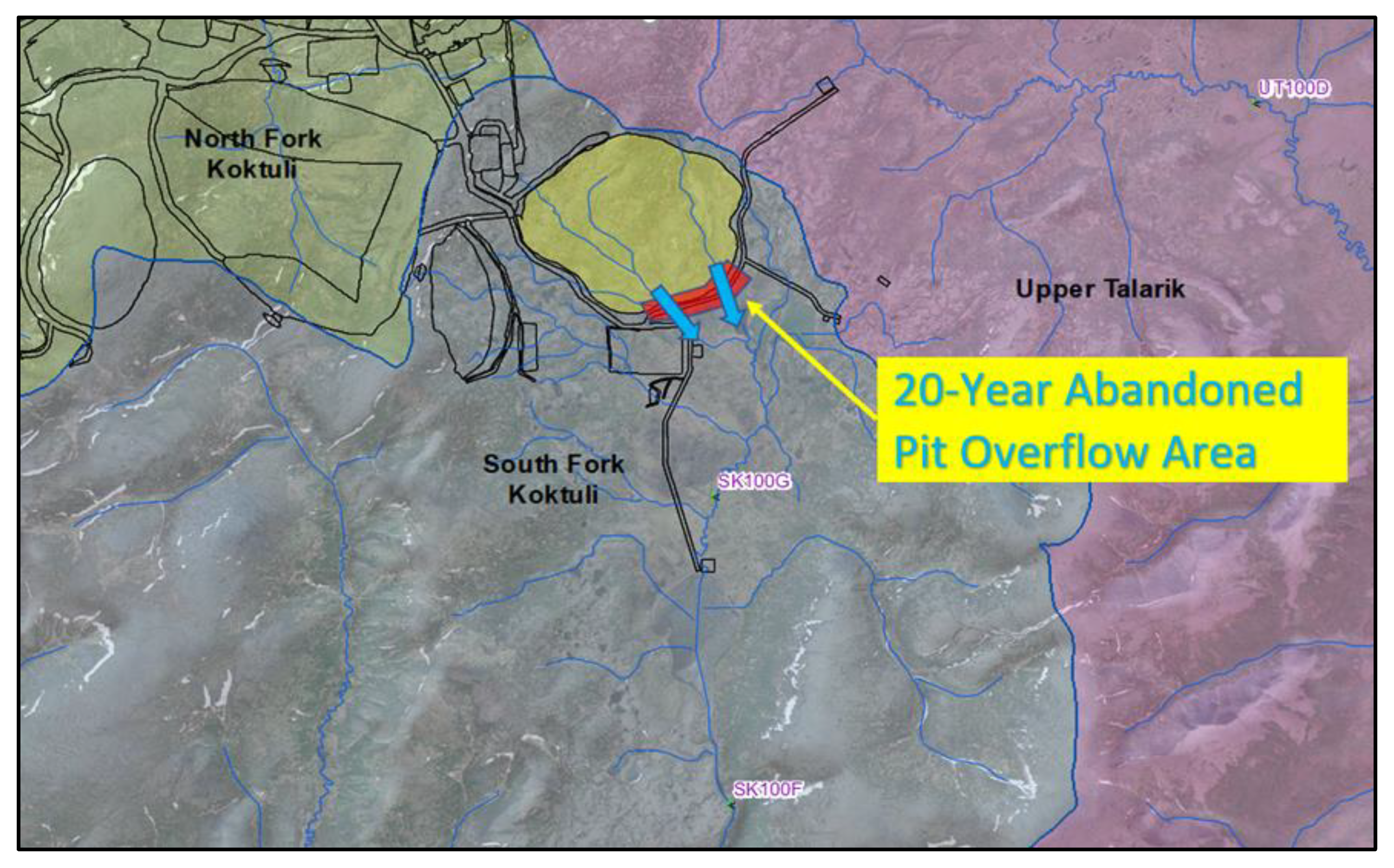
3.1.4. Failure Modes and Abandonment Scenario
3.2. Fate and Transport of Pit Lake Overflow and Outflow
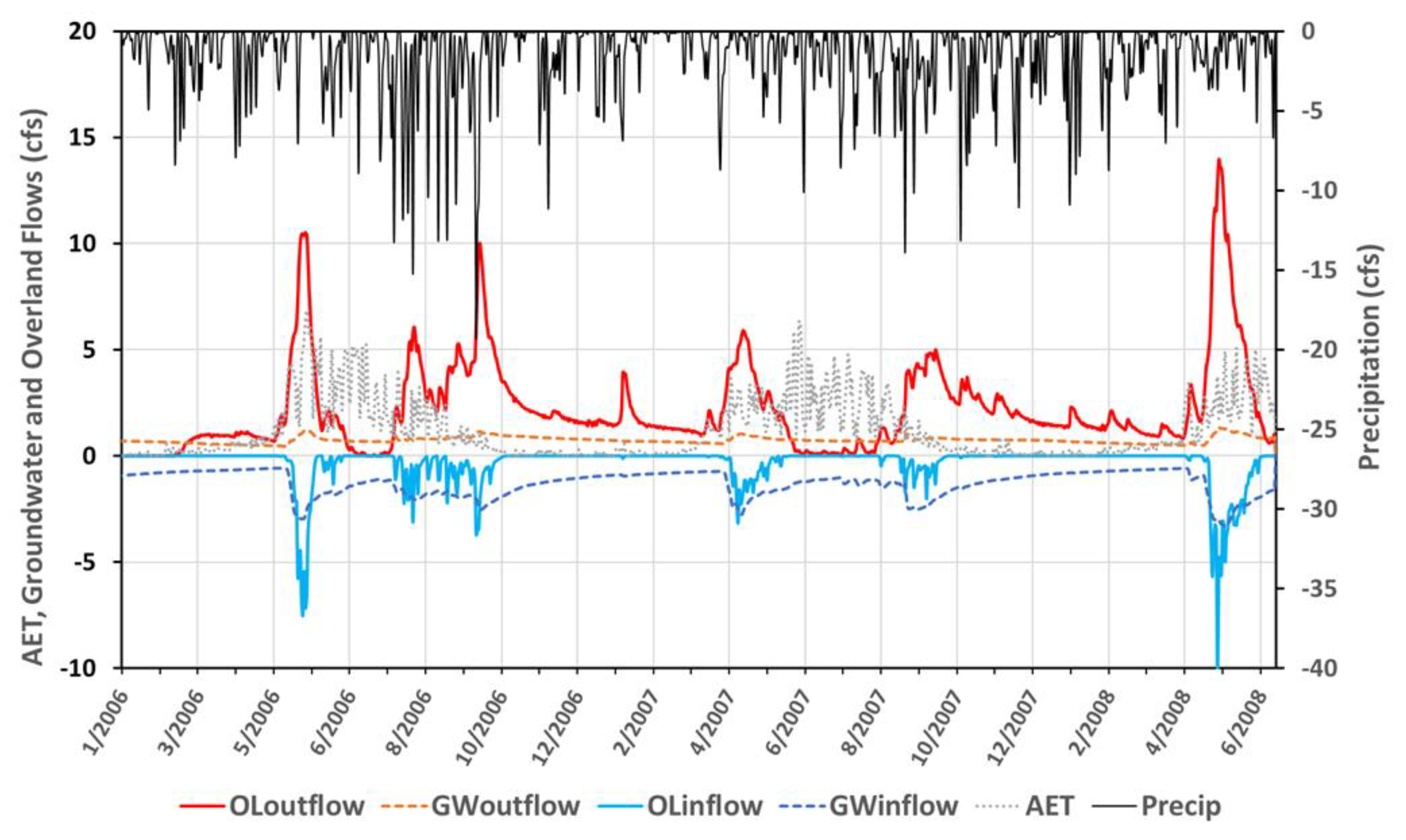
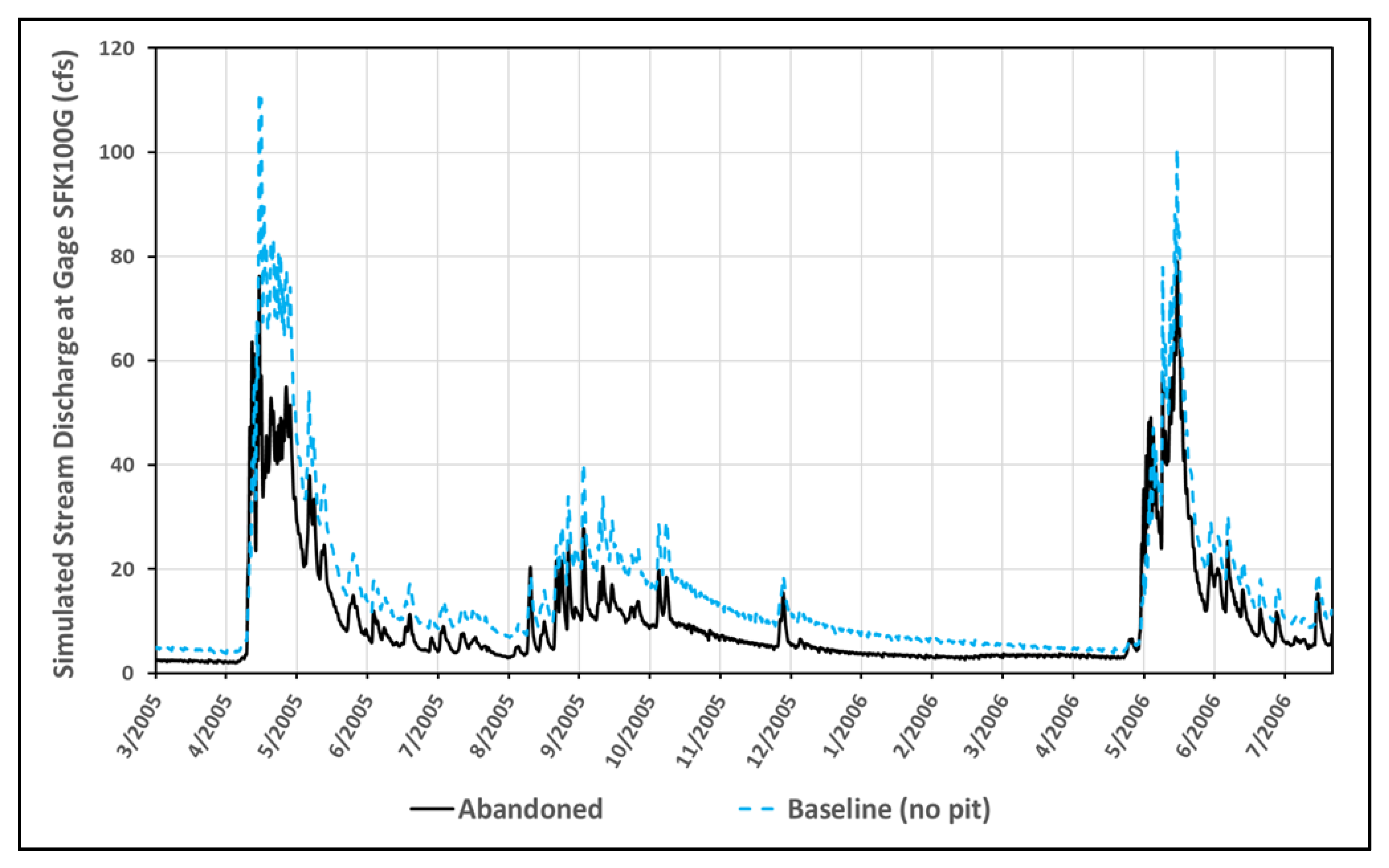
3.2.1. Prediction of Pit Lake Abandonment and Effects on Water Flows
3.2.2. Prediction of Pit Lake Water Quality Using DEIS Inputs and PHREEQC Modeling
3.2.3. Prediction of Water Quality Effects to the South Fork Koktuli River from Management Failure or Abandonment
3.2.4. Discussion of Uncertainty
4. Conclusions
Supplementary Materials
Author Contributions
Funding
Acknowledgments
Conflicts of Interest
References
- Nordstrom, D.K. Hydrothermal processes governing the origin, transport and fate of major and trace elements from mine wastes and mineralized rock to surface water. Appl. Geochem. 2011, 26, 1777–1791. [Google Scholar] [CrossRef]
- Bredehoeft, J. The conceptualization model problem—Surprise. Hydrogeol. J. 2005, 13, 37–46. [Google Scholar] [CrossRef]
- Davis, A.; Eary, L.E. Pit lake water quality in the western United States: An analysis of chemogenetic trends. Min. Eng. 1997, 46, 98–102. [Google Scholar]
- Kuipers, J.R.; Maest, A.L.; MacHardy, K.A.; Lawson, G. Comparison of Predicted and Actual Water Quality at Hardrock Mines: The Reliability of Predictions in Environmental Impact Statements; Prepared for Earthworks: Washington, DC, USA, 2006; Available online: https://pebbleprojecteis.com/files/81bbe585-36ce-49d3-a782-ea43a574f09f (accessed on 28 June 2020).
- Beddoes, P.; Herrell, M.; Vandenberg, J.; Richards, J.; Millar, R.; McMahen, K. Validation of Springer Pit Lake Water Balance and Water Quality Model, Mount Polley Mine, British Columbia, Canada. In Proceedings of the IMWA 2016, Freiberg, Germany, 11–15 July 2016; pp. 251–260. [Google Scholar]
- Newman, C.P.; Cluff, T.; Gray, T.; Beale, G. Aqueous Geochemistry and Limnology of the Sleeper Pit Lake, Nevada, USA: Evidence for Long-Term Subaqueous Solute Generation in Mine Pit Lakes. J. Geosci. Environ. Prot. 2019, 7, 64–81. [Google Scholar] [CrossRef]
- Parbhakar-Fox, A.; Lottermoser, B.G. A critical review of acid rock drainage prediction methods and practices. Miner. Eng. 2015, 82, 107–124. [Google Scholar] [CrossRef]
- Maest, A.S.; Nordstrom, D.K. A geochemical examination of humidity cell tests. Appl. Geochem. 2017, 81, 109–131. [Google Scholar] [CrossRef]
- Banwart, S.A.; Evans, K.A.; Croxford, S. Predicting mineral weathering rates at field scale for mine water risk assessment. Geol. Soc. London Spec. Publ. 2002, 198, 137–157. [Google Scholar] [CrossRef]
- Bornhorst, T.J.; Logsdon, M.J. Predicting Future Water-Quality Impacts from Mining: A 52-Year-Old Field Analog for Humidity Cell Testing, Copperwood Deposit, Michigan. Econ. Geol. 2016, 111, 527–542. [Google Scholar] [CrossRef]
- Lapakko, K.; Olson, M. Scaling Laboratory Sulfate Release Rates to Operational Waste Rock Piles. In Proceedings of the 10th ICARD/IMWA Annual Meeting, Santiago, Chile, 20–25 April 2015; p. 15. [Google Scholar]
- Ruggerone, G.T.; Peterman, R.M.; Dorner, B.; Myers, K.W. Magnitude and Trends in Abundance of Hatchery and Wild Pink Salmon, Chum Salmon, and Sockeye Salmon in the North Pacific Ocean. Mar. Coast. Fish. 2010, 2, 306–328. [Google Scholar] [CrossRef]
- Bowell, R.J. The hydrogeochemical dynamics of mine pit lakes. Geol. Soc. London Spec. Publ. 2002, 198, 159–185. [Google Scholar] [CrossRef]
- U.S. Environmental Protection Agency. Consideration of Cumulative Impacts in EPA Review of NEPA Documents. Office of Federal Activities (2252A). EPA 315-R-99-002/May 1999. Available online: https://www.epa.gov/sites/production/files/2014-08/documents/cumulative.pdf (accessed on 26 June 2020).
- U.S. Army Corps of Engineers. 2019; Pebble Project EIS. Draft Environmental Impact Statement. February. https://www.pebbleprojecteis.com/documents/eis; and U.S. Army Corps of Engineers. Pebble Project EIS. Final Environmental Impact Statement; 2020. Available online: https://pebbleprojecteis.com/documents/finaleis (accessed on 29 June 2020).
- Gammons, C.H.; Duaime, T.E. Long Term Changes in the Limnology and Geochemistry of the Berkeley Pit Lake, Butte, Montana. Mine Water Environ. 2006, 25, 76–85. [Google Scholar] [CrossRef]
- SENES Consultants Ltd. Assessment of Water Treatment Methods Applicable for Closure, Red Dog Mine, Alaska. Prepared for Teck Cominco Alaska Inc; 2004. Available online: http://dnr.alaska.gov/mlw/mining/largemine/reddog/publicnotice/pdf/sde4.pdf (accessed on 26 June 2020).
- U.S. Army Corps of Engineers. Donlin Gold Project. Final Environmental Impact Statement. Chapter 3: Environmental Analysis, 3.6 Groundwater Hydrology; 2018. Available online: https://eplanning.blm.gov/public_projects/nepa/35860/154866/189534/Sec_3.6_Groundwater_Hydrology.pdf (accessed on 26 June 2020).
- New Mexico Office of the Natural Resource Trustee. Final Groundwater Restoration Plan for the Chino, Cobre, and Tyrone Mine Facilities. 2012. Available online: https://www.cerc.usgs.gov/orda_docs/DocHandler.ashx?task=get&ID=1177 (accessed on 25 June 2020).
- Prucha, R.; Graham, D.; Watson, M.; Avenant, M.; Esterhuyse, S.; Joubert, A.; Kemp, M.; King, J.; Le Roux, P.; Redelinghuys, N.; et al. MIKE-SHE integrated groundwater and surface water model used to simulate scenario hydrology for input to DRIFT-ARID: The Mokolo River case study. Water SA 2016, 42, 384. [Google Scholar] [CrossRef]
- Wobus, C.; Prucha, R.; Albert, D.; Woll, C.; Loinaz, M.; Jones, R. Hydrologic Alterations from Climate Change Inform Assessment of Ecological Risk to Pacific Salmon in Bristol Bay, Alaska. PLoS ONE 2015, 10, e0143905. [Google Scholar] [CrossRef] [PubMed]
- Parkhurst, D.L.; Appelo, C.A.J. User’s Guide to Phreeqc (Version 2): A Computer Program for Speciation, Batch-Reaction, One-Dimensional Transport, and Inverse Geochemical Calculations. Water-Resources Investigations Report 99–4259; 1999. Available online: https://pubs.er.usgs.gov/publication/wri994259 (accessed on 28 June 2020).
- Lorax Environmental Technical Memorandum: Pebble Project Pit Lake–Water Quality Predictions. To: Loretta Ford, Pebble Limited Partnership. From: Alan Martin, Don Dunbar, Silvano Salvador. 2018. Available online: https://pebbleprojecteis.com/documents/finaleis (accessed on 28 June 2020).
- Knight Piésold. Pebble Project. Pebble Mine Site-Closure Water Management Plan. Prepared for: Pebble Limited Partnership. 2018. Available online: https://pebbleprojecteis.com/documents/finaleis (accessed on 28 June 2020).
- SRK Consulting (Canada) Inc. Geochemical Source Terms for Water Treatment Planning, Pebble Project–Operational Phase. Report prepared for Pebble Limited Partnership. SRK Project 1CP016.010. 2018. Available online: https://pebbleprojecteis.com/documents/finaleis (accessed on 28 June 2020).
- HDR. Pebble Base-Case Water Treatment Plant Engineering Revision. 2018. Available online: https://pebbleprojecteis.com/documents/finaleis (accessed on 28 June 2020).
- Knight Piésold. Letter report to Mr. James Fueg, PLP, Re: Pebble Project: RFI 019 Part 4 Influence of Geological Structures on Groundwater Flow Conditions. 2018. Available online: https://pebbleprojecteis.com/documents/finaleis (accessed on 28 June 2020).
- Golder Associates. Hydrologic Data Report–Water Year 2018. Buckhorn Mine. Submitted to: Crown Resources Corporation; 2019. Available online: https://apps.ecology.wa.gov/paris/DocumentSearch.aspx (accessed on 13 March 2019).
- Rucker, D.; Glaser, D.R.; Osborne, T.; Maehl, W.C. Electrical Resistivity Characterization of a Reclaimed Gold Mine to Delineate Acid Rock Drainage Pathways. Mine Water Environ. 2009, 28, 146–157. [Google Scholar] [CrossRef]
- Gammons, C.H.; Harris, L.N.; Castro, J.M.; Cott, P.A.; Hanna, B.W. Creating Lakes from Open Pit Mines: Processes and Considerations, with Emphasis on Northern Environments; Canadian Technical Report of Fisheries and Aquatic Sciences, 2826; Government of Canada, Fisheries and Oceans Canada: Ottawa, ON, Canada, 2009; p. 106.
- Plumlee, G.; Logsdon, M.; Filipek, L. The Environmental Geology of Mineral Deposits. Environ. Geochem. Mineral Depos. 1997, 6A, 71–116. [Google Scholar] [CrossRef]
- Pebble Limited Partnership (PLP). Pebble Project Supplemental Environmental Baseline Data Report (2004-2012). 11. Geochemical Characterization, Bristol Bay Drainages. 2018. Available online: https://pebbleprojecteis.com/documents/finaleis (accessed on 28 June 2020).
- INAP (International Network for Acid Prevention). GARD (Global Acid Rock Drainage Guide. Revised as of 17 December 2018. 2009. Available online: http://www.gardguide.com/index.php?title=Main_Page (accessed on 28 June 2020).
- Newbrough, P.; Gammons, C.H. An experimental study of water–rock interaction and acid rock drainage in the Butte mining district, Montana. Environ. Geol. 2002, 41, 705–719. [Google Scholar] [CrossRef]
- Nordstrom, D.K. Aqueous Pyrite Oxidation and the Consequent Formation of Secondary Iron Minerals. In SSSA Special Publications; Soil Science Society of America: Madison, WI, USA, 2015; pp. 37–56. [Google Scholar]
- Nordstrom, D.K.; Alpers, C.N. Geochemistry of Acid Mine Waters. In The Environmental Geochemistry of Mineral Deposits. Part A: Processes, Techniques and Health Issues; Reviews in Economic Geology, Plumlee, G.S., Logsdon, M.J., Eds.; Society of Economic Geologists: Littleton, CO, USA, 1999; Volume 6A, pp. 133–160. [Google Scholar]
- Jambor, J.L.; Nordstrom, D.K.; Alpers, C.N. Metal-sulfate salts from sulfide mineral oxidation. In Sulfate Minerals–Crystallography; Alpers, C.N., Jambor, J.L., Nordstrom, D.K., Eds.; Mineralogical Society of America: Washington, DC, USA, 2000; Volume 40, pp. 303–350. [Google Scholar]
- Miller, G.C.; Lyons, W.B.; Davis, A. Peer Reviewed: Understanding the Water Quality of Pit Lakes. Environ. Sci. Technol. 1996, 30, 118A–123A. [Google Scholar] [CrossRef] [PubMed]
- Plumlee, G.S.; Smith, K.S.; Montour, M.R.; Ficklin, W.H.; Mosier, E.L. Geologic Controls on the Composition of Natural Waters and Mine Waters Draining Diverse Mineral-Deposit Types. In The Environmental Geochemistry of Mineral Deposits. Part B. Case Studies and Research Topics; Reviews in Economic Geology; Filipek, L.H., Plumlee, G.S., Eds.; Society of Economic Geologists: Littleton, CO, USA, 1999; Volume 6B, pp. 373–432. [Google Scholar]
- Albert, D.M. Direct loss of Salmon Streams, Tributaries and Wetlands under the Proposed Pebble Mine Compared with Thresholds of Unacceptable Adverse Effects in the EPA Proposed Determination Pursuant to Section 404(c) of the Clean Water Act; The Nature Conservancy: Arlington, VA, USA, 2019; p. 14. [Google Scholar] [CrossRef]
- Nordstrom, D.K. Models, validation, and applied geochemistry: Issues in science, communication, and philosophy. Appl. Geochem. 2012, 27, 1899–1919. [Google Scholar] [CrossRef]
- Oreskes, N.; Shrader-Frechette, K.; Belitz, K. Verification, Validation, and Confirmation of Numerical Models in the Earth Sciences. Science 1994, 263, 641–646. [Google Scholar] [CrossRef] [PubMed]
- Knight Piésold. Pebble Project Water Balance and Water Quality Model Report. Prepared for Pebble Limited Partnership. Prepared by Knight Piésold Ltd. VA101-176/60-3. 2019. Available online: https://pebbleprojecteis.com/documents/finaleis (accessed on 27 June 2020).
- SRK Consulting Inc. Summary of Update to Geochemical Source Terms Originally Issued in August 2018, Pebble Project. SRK Memo to PLP. 2019. Available online: https://pebbleprojecteis.com/documents/finaleis (accessed on 28 June 2020).



| Pit Lake Inflow Descriptions | Water Quality Source Terms and Assumptions [24] | Solution Number for Mixing in PHREEQC | Mixing Percentages Used in PHREEQC | Water Quality Source Terms Used in PHREEQC |
|---|---|---|---|---|
| Direct Precipitation | Pit wall source term | 1 (Pre-Tertiary acidic, 90%); 2 (Tertiary non-acidic, 10%) | 1: 17.5% 2: 1.9% | Pit wall source term 1; (subtracted total evaporation) |
| Undisturbed Surface Runoff | SFK 100F | 4 | 4: 8.60% | SFK 100F 2 |
| Diversion Channel Leakage | SFK 100F | 4 | SFK 100F | |
| Groundwater | Pit area groundwater | 3 | 3: 16.0% | Pit area groundwater 2 |
| Additional Snow Blow | Pit wall source term | 1 and 2 | Pit wall source term 1 | |
| Pyritic Tailings Re-Slurry Water to Open Pit | Calculated concentrations in PTSF (assuming full mixing) | 5 | 5: 20.1% | Open Pit-Closure, Backfilled Waste Rock, high pyritic tailings 3 |
| Pit Wall Runoff | Pit wall source term | 1 | Pit wall source term | |
| Reject Flows and Sludge Flows from WTP #2 | WTPs—sludge and reject concentrations | 6 (sludge) and 7 (reject brine) | 6: 2.47% 7: 0.23% | WTP sludge and WTP reject 4 |
| Reject Flows and Sludge Flows from WTP #3 | WTPs—sludge and reject concentrations | 6 (sludge) and 7 (reject brine) | WTP sludge and WTP reject | |
| Surplus from Bulk TSF-Phase 2 | Bulk TSF | 8 | 8: 3.2% | Bulk TSF, Closure Phase 2 5 |
| Surplus from Bulk TSF-Phase 3 | Bulk TSF | 9 | 9: 27.9% | Bulk TSF, Closure Phase 3 6 |
| Surplus from Bulk TSF Main SCP | Calculated concentrations in Main Embankment SCP | 10 | 10: 2.2% | Bulk TSF Main Embankment SCP, Closure Phase 2 5 |
| Analyte | Range | Mean b |
|---|---|---|
| pH (field, Standard Units) | 3.54–8.85 | 6.63 |
| Water Temperature (°C) | −0.33–23.4 | 4.33 |
| Specific Conductance (field, μS/cm) | 20–133 | 52.3 |
| Calcium (mg/L, dissolved) | 2.28–13.4 | 6.18 |
| Magnesium (mg/L, dissolved) | 0.35–3.9 | 1.4 |
| Sodium (mg/L, dissolved) | 1.09–4.67 | 2.33 |
| Potassium (mg/L, dissolved) | 0.12–1.07 | 0.36 |
| Alkalinity (total; mg/L as CaCO3) | 3.1–40 | 18 |
| Sulfate (mg/L) | 0.90–28.8 | 8 |
| Chloride (mg/L) | 0.14–1.45 | 0.69 |
| Fluoride (mg/L) | 0.031–0.23 | 0.044 |
| Hardness (mg/L as CaCO3) | 7.91–52.9 | 20.5 |
| Cadmium (μg/L, dissolved) | 0.0062–0.074 | 0.019 |
| Copper (μg/L, dissolved) | 0.15–4.9 | 1.1 |
| Lead (μg/L, dissolved) | 0.022–0.42 | 0.072 |
| Zinc (μg/L, dissolved) | 0.47–11 | 2.8 |
| 20-Year Pit | 78-Year Pit | |||
|---|---|---|---|---|
| Flow Component | Managed | Abandoned | Managed | Abandoned |
| GW outflow | 0.0 | 0.7 | 0.0 | 3.4 |
| GW inflow | −2.4 | −1.3 | −35.6 | −39.6 |
| SW outflow 1 | 0.0 | 2.4 | 118 | 36.0 |
| SW inflow | −0.3 | −0.4 | −1.6 | −1.7 |
| Precipitation | −1.6 | −1.6 | −7.6 | −8.1 |
| AET | 1.2 | 1.2 | 9.8 | 10.5 |
| Parameter (mg/L or SU) | Lorax Environmental (2018), Closure Year 105 a | PHREEQC Predicted Pit Lake, Closure Year 105 b | SFK WQC (mg/L) c | Lorax: Conc/WQC | PHREEQC: Conc/WQC | Berkeley Pit, MT, USA 10/16/87 d |
|---|---|---|---|---|---|---|
| pH | 8.10 | 3.54 | 6.5–8.5 | NA | NA | 2.8 |
| Al | 1.0 | 155 | 0.087 | 11.5 | 1780 | – |
| B | 0.034 | 0.06 | 0.75 | 0.0 | 0.08 | – |
| Ba | 0.015 | 0.04 | 2 | 0.0 | 0.02 | – |
| Ca | 59 | 308 | – | NA | NA | 462 |
| Cd | 0.0017 | 0.231 | 0.00008 | 21.3 | 2890 | 1.3 |
| Cu | 0.27 | 130 | 0.00219 | 123 | 56,200 | 156 |
| Fe | 1.7 | 395 | 1 | 1.7 | 382 | 386 |
| Mn | 0.89 | 14.1 | 0.05 | 17.8 | 282 | 95 |
| Pb | 0.0038 | 0.020 | 0.00039 | 9.7 | 51.3 | – |
| SO4 | 173 | 3140 | 250 | 0.7 | 12.6 | 5740 |
| Zn | 0.18 | 34.8 | 0.02895 | 6.2 | 1200 | 280 |
© 2020 by the authors. Licensee MDPI, Basel, Switzerland. This article is an open access article distributed under the terms and conditions of the Creative Commons Attribution (CC BY) license (http://creativecommons.org/licenses/by/4.0/).
Share and Cite
Maest, A.; Prucha, R.; Wobus, C. Hydrologic and Water Quality Modeling of the Pebble Mine Project Pit Lake and Downstream Environment after Mine Closure. Minerals 2020, 10, 727. https://doi.org/10.3390/min10080727
Maest A, Prucha R, Wobus C. Hydrologic and Water Quality Modeling of the Pebble Mine Project Pit Lake and Downstream Environment after Mine Closure. Minerals. 2020; 10(8):727. https://doi.org/10.3390/min10080727
Chicago/Turabian StyleMaest, Ann, Robert Prucha, and Cameron Wobus. 2020. "Hydrologic and Water Quality Modeling of the Pebble Mine Project Pit Lake and Downstream Environment after Mine Closure" Minerals 10, no. 8: 727. https://doi.org/10.3390/min10080727
APA StyleMaest, A., Prucha, R., & Wobus, C. (2020). Hydrologic and Water Quality Modeling of the Pebble Mine Project Pit Lake and Downstream Environment after Mine Closure. Minerals, 10(8), 727. https://doi.org/10.3390/min10080727


