Unraveling Misunderstandings about Desertification: The Paradoxical Case of the Tabernas-Sorbas Basin in Southeast Spain


1
Instituto Multidisciplinar para el Estudio del Medio “Ramón Margalef”, Universidad de Alicante, Carretera de San Vicente del Raspeig s/n, 03690 San Vicente del Raspeig, Spain
2
Departamento de Ecología, Universidad de Alicante, Carretera de San Vicente del Raspeig s/n, 03690 San Vicente del Raspeig, Spain
*
Author to whom correspondence should be addressed.
Land 2020, 9(8), 269; https://doi.org/10.3390/land9080269
Submission received: 9 July 2020
/
Revised: 7 August 2020
/
Accepted: 9 August 2020
/
Published: 11 August 2020
(This article belongs to the Special Issue Landscape Transformation and Changes in Land Use Intensity)
Abstract
:From its origins, the concept of desertification has been controversial. The prevailing confusion between two desertification visions, one that considers it as the expansion of deserts and another that emphasizes its anthropogenic component, has been transferred to society. Here we illustrate misunderstandings about desertification using a very illustrative case from the Tabernas-Sorbas Basin (Almeria, Spain), where striking badlands that are often used as an image of desertification coexist with an intensive olive agriculture that is irreversibly deteriorating the only oasis in continental Europe (Los Molinos spring). The olive tree is a traditional Mediterranean dryland crop and until the 1950s only about 200 ha were irrigated in this area. However, the profitability of the crop has caused irrigation to expand to 4400 ha in the last two decades. The process of intensification has been reinforced giving way to super-intensive irrigation, which involves going from 210 to 1550 trees/ha, which in a few years already occupies more than 1500 ha. The effects on the water balance of the aquifer feeding these crops have been severe, and the flow of the Los Molinos spring has gone from more than 40 L/s for the period 1970–2000 to the current 7.28 L/s. Unraveling the mechanisms of land degradation and its main drivers are the first step to propose management actions to achieve a more sustainable use of resources and to combat desertification.
1. Introduction
The magnitude and importance of desertification, the first global environmental issue to be recognized as such [1], led to the establishment of the United Nations Convention to Combat Desertification (UNCCD), a degree of political and environmental importance only achieved by the Conventions on Biodiversity and Climate Change. The UNCCD, adopted in 1994 and currently ratified by 196 countries, defines desertification as “land degradation in arid, semi-arid and dry sub-humid areas resulting from various factors including climatic variation and human activity” [2]. Drylands occupy roughly 41% of Earth’s surface [3], and are home to over 38% of the world’s human population [4].
Despite the refinement of the concept of desertification carried out for decades [5,6], this environmental problem is still being discussed and plagued with conceptual doubts [7,8,9,10] (D’Odorico, Bhattachan, Davis, Ravi, & Runyan, 2013; Geist & Lambin, 2004; Verón, Paruelo, & Oesterheld, 2006). One of the most frequent confusions, especially in the Mediterranean, is to equate erosion and desertification [11,12]. This leads to the confusion of erosive landscapes such as badlands, which are the result of their geological history [13], with episodes of erosion caused by poor land management such as overgrazing (see Section S1 in Supplemental Materials). Key desertification drivers are often ignored or minimized. This is the case of the overexploitation of groundwater, an invisible problem whose magnitude has skyrocketed in the last decades with the irrigation boom experienced by many drylands worldwide [14,15]. Another source of misunderstanding is the association of desertification to the expansion of deserts [16]. Deserts are mature ecosystems with very low productivity due to severe water limitations promoted by low rainfall and high evapotranspiration levels [17], and have evolved under this state for a long period (see Section S2 for details). Part of this confusion is also spurred by the aridification of the planet due to climate change [18] and the associated increase in the area of drylands [3,19]. is often associated to desertification.
The distortion of the concept of desertification (see Section S3) is not new. The sensationalism surrounding the first world summits on desertification does not seem to have been diluted today and images of deserts or cracking soil are still used by institutions [16] and scientists [20,21] alike when referring to desertification. These messages have been propagated and amplified in the media. Typically, to report desertification, a desolate landscape is used as a background to the news. The headlines in the mainstream media replicate the same mistake over and over again (e.g., “Sahara Jumps Mediterranean into Europe” (Guardian of London, 20 December 2000), “Expanding Desert-An urgent problem” (China Daily, 30 June 2001).
The badlands of Tabernas, in Almería (SE Spain, Figure 1A), are one of the most used examples when the media talk about desertification in Spain (see Section S4). Doing so is a double conceptual error. On the one hand, Tabernas is not a true desert as it does not meet the climatic criteria used to define a desert (see Section S2). On the other hand, the identification of an erosive landscape with desertification deviates completely from the real reasons for land degradation in the area. Since the mid-1990s, there has been an increasing demand for irrigated water for different crops in Almería, including high-density irrigated olive production [22,23]. This dynamic does not escape the Tabernas valley, which began a few decades ago with the irrigation of traditional rainfed crops. By 2000, 1500 out of 2507 ha of dry farmland had been converted to irrigation [24]. In the wake of the development of successful marketing campaigns, the profitability of the crop, and the support of the EU subsidies, the irrigated area of the olive grove in Tabernas has not stopped growing and expanding towards the east to reach 4480 ha in 2018 [25]. This is a very clear case of how the decoupling of the use of resources from their natural provision [26] causes an imbalance that, after crossing critical thresholds, ends in an irreversible degradation of the territory.
The implementation of super-intensive olive irrigation began in the 1990s in Catalonia and expanded to other regions of Spain [27]. It is now a widely extended practice that nowadays occupy more than 100,000 ha in Australia, Chile, Argentina, the United States of America, and multiple Mediterranean countries [28]. This number continues to grow due to the profitability of a fully mechanized way of cropping that requires much less labor than normal irrigation.
Using the Tabernas valley as a case study, we documented an actual case of active desertification driven by a dramatic change in land-use (from rainfed to super-intensive irrigated farming), which is incompatible with the valley’s climate and geology (Figure S1). Our objective was to document the expansion and intensification of the irrigated olive grove in this area, and to study its impact on the groundwater body supporting this land use. To achieve this objective, we: (i) measured the surface of irrigated and super-intensive orchards by photo-interpretation, and (ii) recorded the water volume of Los Molinos spring, which feeds on the aquifer, in the period of 1973-2016. Our working hypothesis is that in a dryland area like the Tabernas-Sorbas Basin, the replacement of traditional cropping systems by highly mechanized and irrigated crops will lead to its desertification.
2. Materials and Methods
2.1. Study Area
The Tabernas–Sorbas Basin is located in the province of Almeria, in the southeast of Spain (Figure 1). The region has a semiarid climate, with a mean annual precipitation of 250 mm per year [29], which can hardly lead to permanent surface runoff. In addition, the rainfall regime in the area, where it is common to find years in which 80% of the water falling corresponds to one or two heavy rains (which usually cause flooding), does not favor infiltration into aquifers. No more than 25% of rainfall, perhaps less, could be considered as "effective rain" capable of infiltrating and reaching the deepest layers of the terrain. Mean annual potential evapotranspiration reaches 1500 mm [30], indicating a considerable annual water deficit [31]; between 6 and 9 moths per year can be considered as dry. Natural vegetation is dominated by sparse dwarf shrubs or tussock grasses (M. tenacissima), whereas annual plants account for more than 50% of the total flora, particularly in wet years. Biological soil crusts dominated by lichens such as Disploschistes diacapsis cover a high proportion of the ground surface [32].
2.2. Main Features of Los Molinos Spring
An extremely unique hydrogeological configuration is the explanation for the fact that the Los Molinos spring, the source of the Aguas river [33] and a true oasis within a very dry territory [34], historically had an average flow of 40 L/s throughout the year [35]. This is so because: (i) its feeding basin is very large (over 150 km2), (ii) groundwater filters over thousands of years through powerful gypsum strata, below which there are impermeable marls and silts preventing further infiltration of water and causing the groundwater to emerge at Los Molinos (Figures 1C and 5A), and (iii) the aquifer feeding this spring, the Alto Aguas aquifer, receives lateral feedings from its surrounding northern mountains [33].
2.3. Measurement of the Surface of Olive Trees
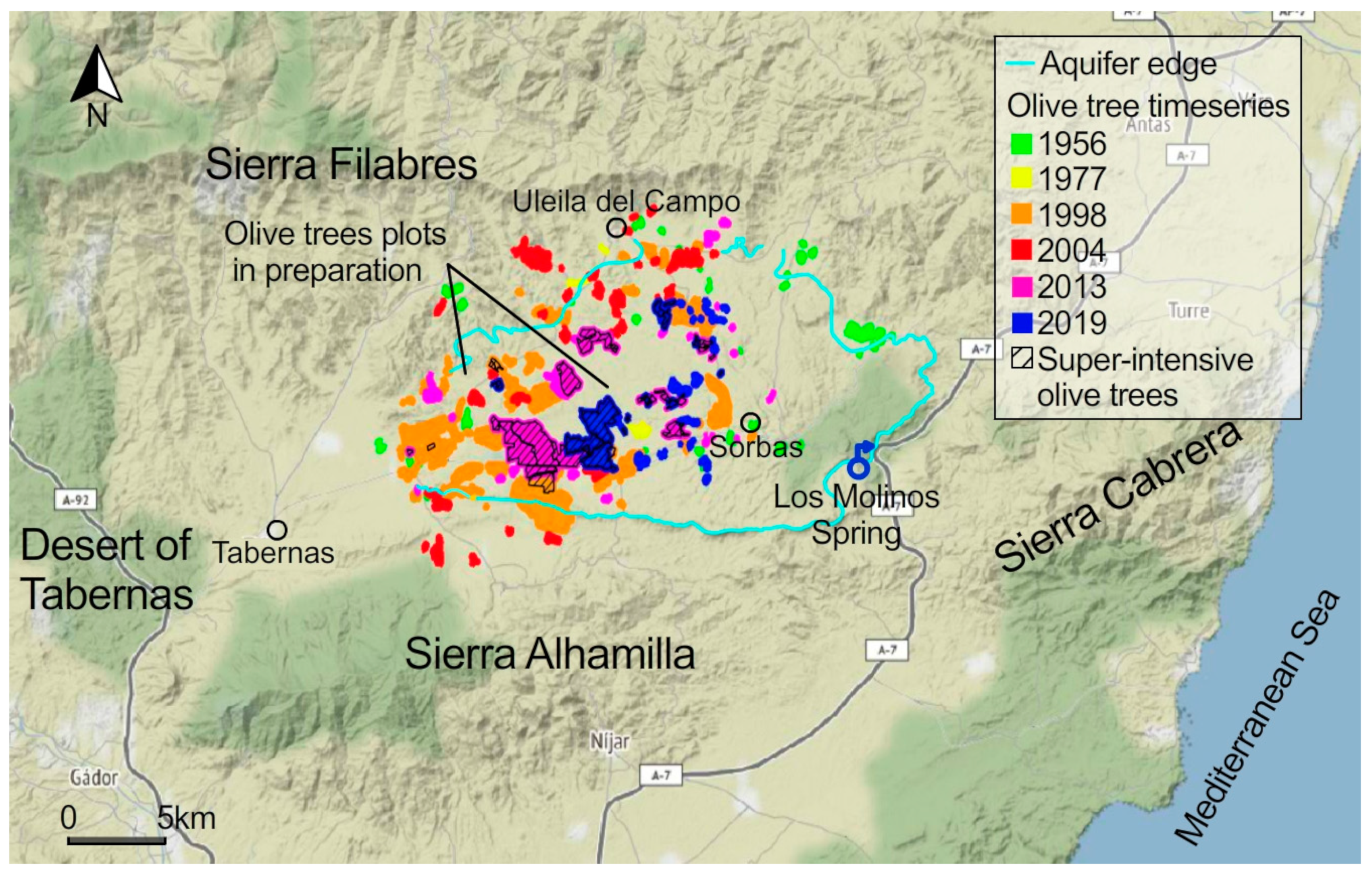
The surface of olive trees was measured by photointerpretation in the years 1956, 1977, 1998, 2004, 2013 and 2019 (Table 1). In 1956 and 1977, aerial imagery with 1 m/pixel of spatial resolution and 1 band from the American and Interministerial flights [36,37], respectively, were used. In 1998, 2004, 2013 and 2019, three-band aerial imagery with 0.5 m/pixel of spatial resolution from the Andalusian Environmental Information Network (REDIAM) [38] and Google Earth [39] were used [40]. To validate the surface of olive trees, the land cover database Spanish Land Occupancy Information System (SIOSE) of 2005, 2009, 2011, and 2013 [41] was used. To differentiate between irrigated and super-intensive olive orchards we used a density of 210 trees/ha and 1550 trees/ha, respectively [42].
3. Results and Discussion
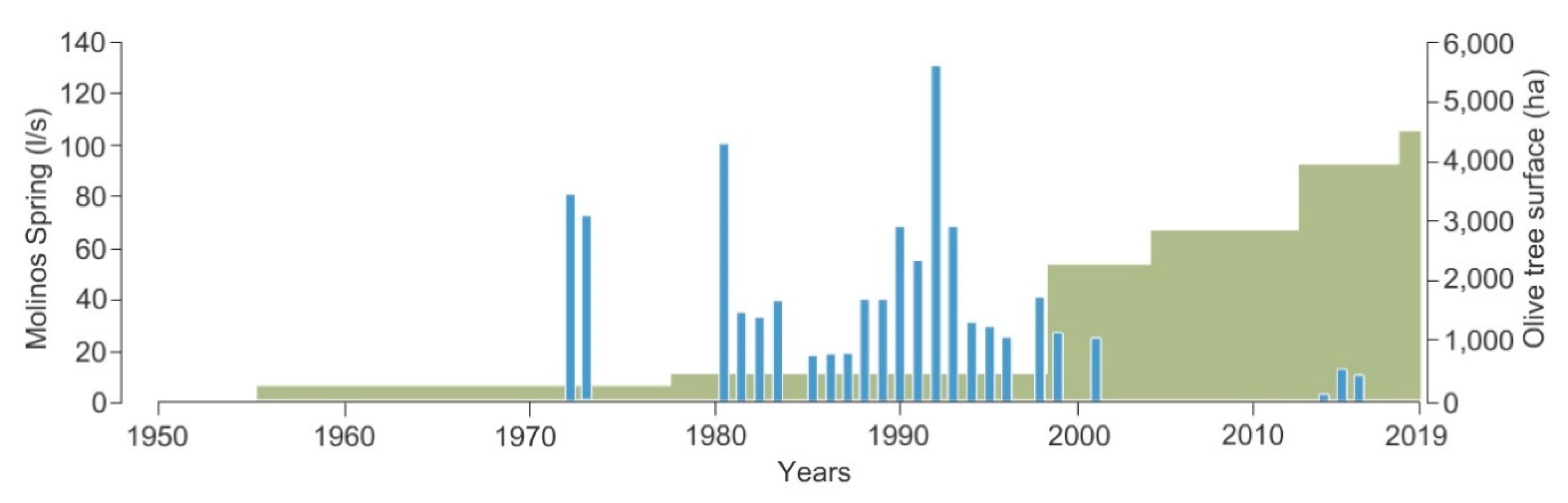
Irrigated olive grove surface has grown from 400 ha in the 1970s to 4336 ha in 2019. Figure 2 and Figure 3 show temporal and spatial evolution of the olive grove surface. This was in response to high market prices for olives (despite the different crises suffered due to overproduction and lack of storage capacity [43]), promotion by favorable CAP subsidies, rural development funds, and plentiful subterranean water supplies [11,23]. In this regard, Spain lies 14th among the countries with higher rates of groundwater depletion worldwide [44], being the third in Europe [45]. This model of intensive irrigation is another example of the three distinctive features of Andalusian irrigation: (i) a conceptualization of water as a highly subsidized resource input; (ii) weak control over water use, and (iii) little responsibility for its environmental and economic costs [46].
The expansion of the olive crop in the study area has been reinforced by a second process of intensification. Traditionally, olives were cultivated under rainfed conditions, taking advantage of the higher humidity found in the “ramblas” (dry beds of temporary rivers, Figure S2), and planted using terraces (Figure S3) that played a very important role in soil stabilization and erosion control [48]. The average density of these dryland olive groves lays typically between 65 and 100 trees/ha [49]. The application of irrigation water results in a significant increase in tree density, up to 210 trees/ha, and yield, from 0.7 t/ha to 2 t/ha [23], and in a considerable reduction of the problem of alternate bearing [50]. This is a characteristic of fruit trees and is accentuated in the olive tree, which shows a high between-year variability in the production of olives [51].
We have detected two types of irrigated olive groves in the area. The first is the conventional irrigated olive grove (Figure S4A), which currently occupies 2832 ha. The second type, the first 10 hectares of which date back only to 2007 [49], is super-intensive olive grove. Here, trees are planted in rows (Figure 4B and Figure S5B) that form continuous fruit-bearing canopy walls [52], a cropping system that facilitates mechanical harvesting, and thus reduces costs [28]. This super-intensive olive grove jumps to a stunning density of 1550 trees/ha (some authors raise the figure to 1670 trees/ha [49]). By 2015 the area under cultivation was already 863 ha and there are currently 1513 ha. The number of trees under each irrigation system expresses well the differences in intensity of each olive grove. In conventional irrigation there are currently about 0.59 million trees while the super-intensive one, with half of the surface, reaches 2.35 million trees. In addition, we have identified 180 ha of new plots in preparation for cultivation. Their location, in the middle of a super-intensive olive monoculture matrix, suggests that this will be its use (see for example Figure S5).
Thus, a traditional Mediterranean rainfed crop that for centuries has been cultivated as open trees in low-density orchards has become a super-intensive monoculture [53] requiring a high economic investment, which is offset by the beginning of olive production just 3-4 years after planting [54]. It is remarkable that this new type of olive grove not only appears in new areas set aside for cultivation, but also replaces olive groves that were already irrigated (Figure S4). The cost of dismantling an irrigated olive grove already in production and planting a new one gives an idea of the profitability of the crop.
The effects of this intensive exploitation system on groundwater quickly appeared. One of the problems associated with groundwater exploitation in the study area is the interconnectivity of water bodies, which causes off-site effects. Thus, the first signs of depletion were reported at Los Molinos, which currently does not exceed 7.28 L/s (Figure 2). This contrasts with the historical average of about 40 L/s with marks exceeding 100 L/s [35]. The observed drop in the flow of the spring mirrors the increase in the cultivation of olive groves under irrigation (Figure 2).
The extreme efficiency of irrigation systems is one of the main arguments used by farmers to defend their use. For intensive olive groves the water use ranges from 2460–3460 m3/ha and for super-intensive ones from 4480–6590 m3/ha [55]. The lower value of the range refers to a deficit irrigation strategy, which is the one used in the study area, while the upper limit indicates the maximum evapotranspiration of the crop during the whole vegetative cycle. Although the efforts to modernize irrigation lead to efficiencies of 90% and 95% in water use under intensive and super-intensive cultivation regimes, respectively [49], a cautious estimate of water consumption for both regimes in the study area is about 14 hm3/year, although other calculations elevate it to 20 hm3/year [49]. In any case, both figures are well above the annual aquifer recharge, which is around 5 hm3 per year [56]. The improvement in irrigation efficiency and the consequent saving of water has not been able to offset the expansion of the olive grove surface area and the increase in belowground water use. This phenomenon is known as Jevons Paradox, which states that "as technological improvement increases the efficiency with which a resource is used, an increase in the consumption of that resource is more likely than a decrease" [57].
Overexploitation of groundwater in the area is not limited to the disappearance of springs. The unsustainable use of water in the study area has been officially recognized by the regional government, which states that the exploitation rate (pumpings – natural recharge ratio) was 3.3, far from the objective value of 0.8 for 2027 [58]. This indicates that the groundwater being pumped exceeded the amount of water available by 230%.
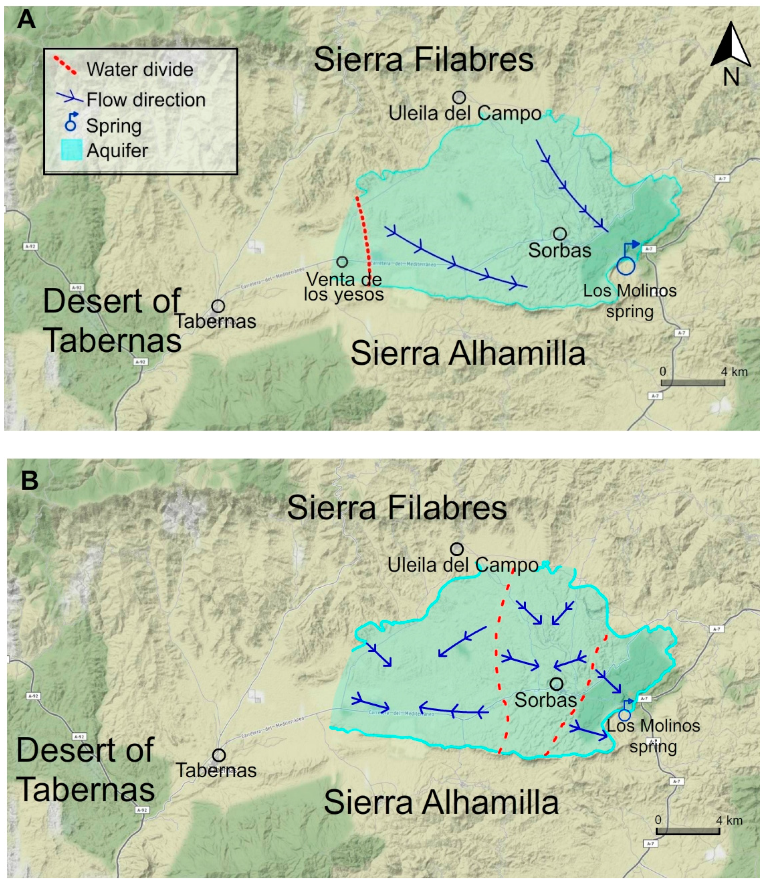
Unsustainable use of water resources is also reflected in qualitative terms. Under natural conditions, the groundwater would move from northwest to southwest in the spring’s recharge basin that extends from Venta de los Yeso and Uleila del Campo to the gypsum escarpment where the Los Molinos spring is located (Figure 5A). With the intense exploitation of water in the aquifer, extraction cones are created towards the exploitation boreholes modifying the piezometric level and the flow to the Los Molinos spring [33]. As a result, water stops flowing towards the spring (Figure 5B).
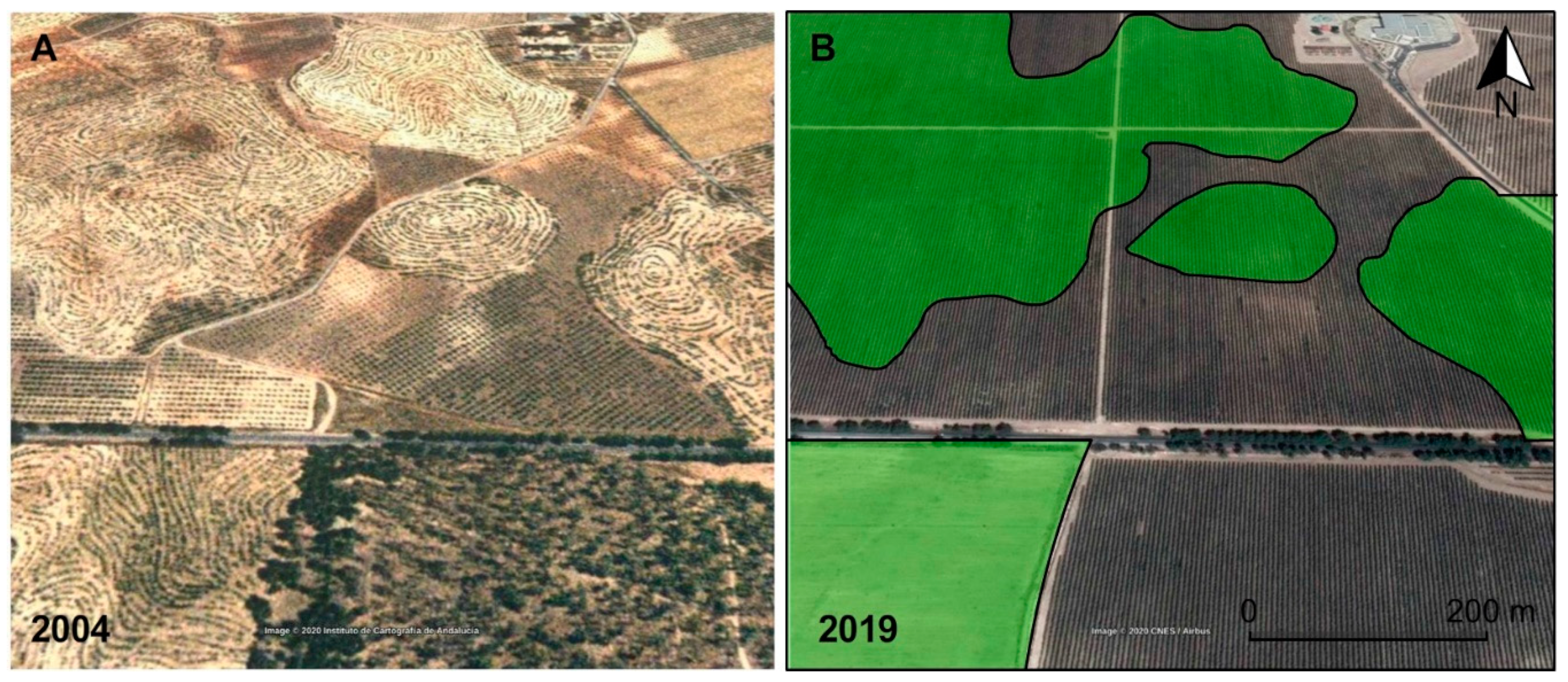
The environmental impact of intensive irrigation olive production is beyond overexploitation of aquifers. Olive orchards are included in the Spanish Plan to Combat Desertification within the desertification landscape “Woody crops affected by soil erosion” [59,60]. The main reason for this inclusion is the common agricultural practice aimed at removing any vegetation cover that exists between tree lines, since it is considered to compete for water and to decrease the yield of the olive grove. Thus, despite the protection offered by the treetops against the direct impact of raindrops, the soil is practically bare, being very vulnerable to runoff, which results in very high erosion rates [61,62]. Moreover, in this geomorphologically sensitive landscape, agricultural clearing and land levelling have triggered erosion and soil loss [23]. The changes that the territory has undergone between 2004 and 2019 to facilitate the mechanization of the monoculture has meant the clearing of small reliefs in order to achieve a flat surface, eliminating any trace of natural vegetation (Figure 4). Given the torrential nature of rainfall in the study area, typical of other dryland regions where 90% of annual precipitation can fall in <1% of the time [63], and its sensitive lithological context [64], such drastic land use change increases the risk of erosion dramatically. The consequences on the biodiversity of the area are not negligible either. The disappearance of the Aguas river also poses a serious threat to the associated wetland and its rich biodiversity (site of community importance ES6110002 Karst en yesos de Sorbas, [65]). However, far from the problem being reversed, the latest satellite images clearly show that the irrigated olive grove continues to expand and new plots await cultivation (Figure S5).
4. Concluding Remarks
The loss of soil and biodiversity and, above all, the overexploitation of groundwater, associated with the uncontrolled growth of irrigated land in the Tabernas-Sorbas Basin is a clear example of desertification. However, its geological landscape reminiscent of Africa has been used as the archetype of desertification in Mediterranean Europe. Indeed, the so-called Desert of Tabernas has been used constantly as a claim that conveys the false idea that desertification is the expansion of deserts. Recent and fast land-use change use is depleting groundwater reserves of Tabernas-Sorbas valley at an alarming rate. This is a case of desertification that fits two of five ‘desertification landscapes’ identified in the Spanish National Plan to Combat Desertification (‘Irrigated crops that trigger desertification processes linked to groundwater exploitation in inland and coastal areas’ and ‘Woody crops affected by soil erosion’) [59,60,66].
Clarifying the conceptual differences between deserts and desertification and the origin of each of them—exclusively climatic the first, anthropogenic the second—is essential to propose effective measures to combat desertification. Considering that desertification is the advance of deserts promotes an idea of catastrophism and bad luck, of causes unconnected to land-use policies that give rise to solutions such as the construction of green barriers that impede their advancement (for example the Algerian army raised up a wall of trees—16 miles wide and 746 miles long—along the entire northern edge of the Sahara [67]). However, the enemy is commonly at home and usually the problems of desertification begin at the same time as the area starts to economically develop. In the case described here, the image of desertification is not the rugged landscape inherited from an interesting geological history but the green areas that have occupied the territory in a very short time thanks to the massive exploitation of groundwater. Unraveling the mechanisms of land degradation makes it possible to detect the main drivers and, with them, to propose management actions to combat it.
In a framework of widespread increases in aridity induced by climate change [19], special care must be taken in the management of natural resources if we do not want the processes of desertification to put an end to the productivity of the world´s drylands. The case introduced here may be useful to answer the rhetorical question of [5], “Do humans cause deserts?” Yes, we do and we should act accordingly.
Supplementary Materials
The following are available online at https://www.mdpi.com/2073-445X/9/8/269/s1; Figure S1: Typical landscape of the Desert of Tabernas where the contrast between the steepest and bare hillsides and the presence of esparto grass (Macrochloa tenacissima) in more stable and less steep hillslopes can be appreciated. (Source: J. Martinez-Valderrama); Figure S2: Traditional dryland olive groves benefiting from the higher humidity naturally found in the “ramblas”; Figure S3: Traditional dryland olive groves on the edge of cultivation terraces; Figure S4: Satellite observations show an intensification of the olive grove. (A) In 2013 (image above) the whole area was covered by olive trees under intensive irrigation. (B) In 2019 (lower image) the lower right plot has been replaced by super-intensive olive grove; Figure S5: New land in preparation for planting olive trees
Author Contributions
Conceptualization, J.M.-V. and F.T.M.; Formal analysis, J.M.-V. and E.G.; Investigation, J.M.-V.; Methodology, E.G.; Supervision, J.M.-V. and F.T.M.; Writing—original draft, J.M.-V.; Writing—review & editing, E.G. and F.T.M. and J.M.-V.; funding acquisition, F.T.M. All authors have read and agreed to the published version of the manuscript.
Funding
This research was funded by the European Research Council grant agreement nº 647038 (BIODESERT). FTM acknowledges support from Generalitat Valenciana (CIDEGENT/2018/041).
Acknowledgments
We are grateful to Professor J.M. Calaforra for providing the most current flow data from the Los Molinos spring. We thank F.J. Alcalá, researcher at IGME, for his valuable hydrogeological opinions on the Sorbas aquifer. We would also like to thank the images provided by the Club Almeriense de Montañismo.
Conflicts of Interest
The authors declare no conflict of interest.
References
- Middleton, N. Deserts: A Very Short Introduction; Oxford University Press: Oxford, UK, 2009. [Google Scholar]
- United Nations: Convention to Combat Desertification in those Countries Experiencing Serious Drought and/or Desertification, Particularly in Africa. Int. Leg. Mater. 1994, 33, 1328–1382. [CrossRef]
- Cherlet, M.; Hutchinson, C.; Reynolds, J.; Hill, J.; Sommer, S.; von Maltitz, G. World Atlas of Desertification; Publication Office of the European Union: Luxembourg, 2018. [Google Scholar]
- Millenium Ecosystem Assessment. Ecosystems and Human Well-Being: Desertification Synthesis; World Resources Institute: Washington, DC, USA, 2005. [Google Scholar]
- Reynolds, J.F.; Stafford Smith, M. Do Humans Cause Deserts? In Global Desertefication: Do Human Cause Deserts; Reynolds, J.F., Stafford Smith, D.M., Eds.; Dahlem University Press: Berlin, Germany, 2002; pp. 1–21. [Google Scholar]
- Zonn, I.S.; Kust, G.S.; Andreeva, O.V. Desertification paradigm: 40 years of development and global efforts. Arid. Ecosyst. 2017, 7, 131–141. [Google Scholar] [CrossRef]
- D’Odorico, P.; Bhattachan, A.; Davis, K.F.; Ravi, S.; Runyan, C.W. Global desertification: Drivers and feedbacks. Adv. Water Resour. 2013, 51, 326–344. [Google Scholar] [CrossRef]
- Geist, H.J.; Lambin, E.F. Dynamic Causal Patterns of Desertification. BioScience 2004, 54, 817. [Google Scholar] [CrossRef] [Green Version]
- Veron, S.R.; Paruelo, J.; Oesterheld, M. Assessing desertification. J. Arid. Environ. 2006, 66, 751–763. [Google Scholar] [CrossRef]
- Sterk, G.; Stoorvogel, J.J. Desertification–Scientific Versus Political Realities. Land 2020, 9, 156. [Google Scholar] [CrossRef]
- Martinez-Fernandez, J.; Esteve, M.A. A critical view of the desertification debate in southeastern Spain. Land Degrad. Dev. 2005, 16, 529–539. [Google Scholar] [CrossRef]
- Puigdefábregas, J. Erosión y desertificación en España. CAMPO 1995, 132, 63–83. [Google Scholar]
- Moreno-De-Las-Heras, M.; Gallart, F. The Origin of Badlands. In Badlands Dynamics in a Context of Global Change; Elsevier BV: Amsterdam, The Netherlands, 2018; pp. 27–59. [Google Scholar]
- Llamas, M.; Martínez-Santos, P. Intensive Groundwater Use: Silent Revolution and Potential Source of Social Conflicts. J. Water Resour. Plan. Manag. 2005, 131, 337–341. [Google Scholar] [CrossRef]
- Martínez-Valderrama, J.; Ibáñez, J.; Alcalá, F.J.; Domínguez, A.; Yassin, M.; Puigdefábregas, J. The use of a hydrological-economic model to assess sustainability in groundwater-dependent agriculture in drylands. J. Hydrol. 2011, 402, 80–91. [Google Scholar] [CrossRef]
- Prince, S.D.; Podwojewski, P. Desertification: Inappropriate images lead to inappropriate actions. Land Degrad. Dev. 2020, 31, 677–682. [Google Scholar] [CrossRef] [Green Version]
- Ward, D. The Biology of Deserts, 2nd ed.; Oxford University Press: Oxford, UK, 2016. [Google Scholar]
- Feng, S.; Fu, Q. Expansion of global drylands under a warming climate. Atmospheric Chem. Phys. Discuss. 2013, 13, 10081–10094. [Google Scholar] [CrossRef] [Green Version]
- Huang, J.; Yu, H.; Guan, X.; Wang, G.; Guo, R. Accelerated dryland expansion under climate change. Nat. Clim. Chang. 2015, 6, 166–171. [Google Scholar] [CrossRef]
- Fantechi, R.; Margaris, N.S. Desertification in Europe. In Proceedings of the Information Symposium in the EEC Programme on Climatology, Mytilene, Greece, 15–18 April 1984; p. 231. [Google Scholar]
- Babaev, G. Desert Problems and Desertification in Central Asia; Springer: Berlin/Heidelberg, Germany, 1999. [Google Scholar]
- Downward, S.; Taylor, R. An assessment of Spain’s Programa AGUA and its implications for sustainable water management in the province of Almería, southeast Spain. J. Environ. Manag. 2007, 82, 277–289. [Google Scholar] [CrossRef]
- Faulkner, H.; Ruiz, J.; Zukowskyj, P.; Downward, S. Erosion risk associated with rapid and extensive agricultural clearances on dispersive materials in southeast Spain. Environ. Sci. Policy 2003, 6, 115–127. [Google Scholar] [CrossRef]
- Alemayehu, T.; Recatalá, L.; Fabbri, A.G.; Sánchez, J. Land use change detection as a basis for analysing desertification processes: A case study in Tabernas (Almeria, Spain). In Desertification in the Mediterranean Region. A Security Issue. Nato Security through Science Series; Kepner, W.G., Rubio, J.L., Mouat, D.A., Pedrazzini, F., Eds.; Springer: Dordrecht, The Netherlands, 2006; Volume 3, pp. 341–352. [Google Scholar]
- Junta de Andalucía. Sistema de Información Multiterritorial de Andalucía (SIMA) [Andalusian Multiterritorial Information System]. Instituto de Estadística y Cartografía de Andalucia. 2020. Available online: https://www.juntadeandalucia.es/institutodeestadisticaycartografia/badea/operaciones/consulta/anual/1954?CodOper=b3_151&codConsulta=1954 (accessed on 3 February 2020).
- Puigdefábregas, J. Desertification: Stress beyond resilience, exploring a unifying process structure. AMBIO 1995, 24, 311–313. [Google Scholar]
- De Gennaro, B.C.; Notarnicola, B.; Roselli, L.; Tassielli, G. Innovative olive-growing models: An environmental and economic assessment. J. Clean. Prod. 2012, 28, 70–80. [Google Scholar] [CrossRef]
- Trentacoste, E.; Connor, D.; Gómez-Del-Campo, M. Row orientation: Applications to productivity and design of hedgerows in horticultural and olive orchards. Sci. Hortic. 2015, 187, 15–29. [Google Scholar] [CrossRef]
- Lázaro, R.; Rodrigo, F.S.; Gutiérrez, L.; Domingo, F.; Puigdefàbregas, J. Analysis of a 30-year rainfall record (1967–1997) in semi–arid SE Spain for implications on vegetation. J. Arid. Environ. 2001, 48, 373–395. [Google Scholar] [CrossRef]
- Calvo-Cases, A.; Harvey, A.M.; Alexander, R.W.; Cantón, Y.; Lázaro, R.; Solé-Benet, A.; Puigdefábregas, J. Badlands in the Tabernas Basin, Betic Chain. In Landscapes and Landforms of Spain; Gutiérrez, F., Gutiérrez, M., Eds.; Springer: Dordrecht, The Netherlands, 2014; pp. 197–211. [Google Scholar]
- Cantón, Y.; Del Barrio, G.; Solé-Benet, A.; Lázaro, R. Topographic controls on the spatial distribution of ground cover in the Tabernas badlands of SE Spain. Catena 2004, 55, 341–365. [Google Scholar] [CrossRef]
- Maestre, F.T.; Escolar, C.; De Guevara, M.L.; Quero, J.L.; Lázaro, R.; Delgado-Baquerizo, M.; Ochoa, V.; Berdugo, M.; Gozalo, B.; Gallardo, A. Changes in biocrust cover drive carbon cycle responses to climate change in drylands. Glob. Chang. Boil. 2013, 19, 3835–3847. [Google Scholar] [CrossRef] [PubMed]
- Calaforra, J.M.; Pulido, A.; Campoy, P.; Cortés, A.; Gázquez, F.; Guirado, C.; Guir, E.; Navarro, F. De dónde viene el agua del Manantial de Los Molinos? Rev. Cult. El AFA 2015, 32, 38–43. [Google Scholar]
- Villalobos, M.; Pérez, A.B. La cuenca y el karst en yesos de Sorbas. In Geodiversidad y Patrimonio Geológico de Andalucía; Junta de Andalucía: Sevilla, Spain, 2006; pp. 183–198. [Google Scholar]
- Jiménez-Sánchez, J.; Rubio-Campos, J.; De la Hera-Portillo, A.; Hueso-Quesada, L. Informe de Caracterización Hidrogeológica y Propuesta de Protección de Manantiales y Lugares de Interés Hidrogeológico (Almería); Instituto Geológico Minero de España: Madrid. Spain, 2011. [Google Scholar]
- Casal, G.; Freire, J. Síntesis de la evolución histórica de la teledetección en España. Rev. de Teledetec. AET 2012, 38, 109–120. [Google Scholar]
- Pérez, J.A.; Bascon, F.M.; Charro, M.C. Photogrammetric usage of 1956–57 USAF aerial photography of Spain. Photogramm. Rec. 2014, 29, 108–124. [Google Scholar] [CrossRef]
- Moreira, J.M. El sistema de información geográfica-ambiental de Andalucía. Del SINAMBA a la Red de Información Ambiental de Andalucía. Geofocus. Rev. Int. Cienc. Tecnol. Inf. Geogr. 2006, 6, 4–10. [Google Scholar]
- Gorelick, N.; Hancher, M.; Dixon, M.; Ilyushchenko, S.; Thau, D.; Moore, R. Google Earth Engine: Planetary-scale geospatial analysis for everyone. Remote Sens. Environ. 2017, 202, 18–27. [Google Scholar] [CrossRef]
- Guirado, E.; Blanco-Sacristán, J.; Rigol-Sanchez, J.P.; Alcaraz-Segura, D.; Cabello, J. A Multi-Temporal Object-Based Image Analysis to Detect Long-Lived Shrub Cover Changes in Drylands. Remote Sens. 2019, 11, 2649. [Google Scholar] [CrossRef] [Green Version]
- Moreira, J.M.; Quijada, J.; Ortega, E.; Romero, D.; Gil, Y. El proyecto SIOSE en Andalucía. In Tecnologías de la Información Geográfica Para el Desarrollo Territorial; Hernández, L., Parreño, J.M., Eds.; Servicio de Publicaciones y Difusión Científica de la ULPGC: Las Palmas de Gran Canaria, Spain, 2008; pp. 941–953. [Google Scholar]
- Rosati, A.; Paoletti, A.; Caporali, S.; Perri, E. The role of tree architecture in super high density olive orchards. Sci. Hortic. 2013, 161, 24–29. [Google Scholar] [CrossRef]
- European Commission. European Commission Approves Private Storage Aid for Olive Oil Sector; European Commission: Brussels, Belgium, 2019. [Google Scholar]
- Wada, Y.; Van Beek, L.P.H.; Bierkens, M. Nonsustainable groundwater sustaining irrigation: A global assessment. Water Resour. Res. 2012, 48. [Google Scholar] [CrossRef]
- Custodio, E.; Andreu-Rodes, J.M.; Aragón, R.; Estrela, T.; Ferrer, J.; García-Aróstegui, J.L.; Manzano, M.; Rodríguez-Hernández, L.; Sahuquillo, A.; Del Villar, A. Groundwater intensive use and mining in south-eastern peninsular Spain: Hydrogeological, economic and social aspects. Sci. Total. Environ. 2016, 559, 302–316. [Google Scholar] [CrossRef] [Green Version]
- Sánchez, D.S.; Del Moral, L. Tres décadas de política de aguas en Andalucía. Análisis de procesos y perspectiva territorial. Cuad. Geogr. 2014, 53, 36–67. [Google Scholar]
- Calaforra, J.M.; Pulido-Bosch, A. Síntesis hidrogeológica sobre los yesos karstificados de Sorbas y su entorno (Almería, España). Boletín Del Inst. de Estud. Almer. Cienc. 1988, 8, 33–48. [Google Scholar]
- Garcia-Ruiz, J.M.; Lana-Renault, N. Hydrological and erosive consequences of farmland abandonment in Europe, with special reference to the Mediterranean region—A review. Agric. Ecosyst. Environ. 2011, 140, 317–338. [Google Scholar] [CrossRef]
- Martinez-Rodriguez, F.J. La necesaria inflexión en la gestión de los recursos hídricos del Campo de Tabernas. Rev. Cult. El AFA 2015, 32, 31–37. [Google Scholar]
- Melgar, J.; Mohamed, Y.; Navarro, C.; Parra, M.; Benlloch, M.; Fernández-Escobar, R. Long-term growth and yield responses of olive trees to different irrigation regimes. Agric. Water Manag. 2008, 95, 968–972. [Google Scholar] [CrossRef]
- Junta de Andalucía. El olivar andaluz; Junta de Andalucía: Sevilla, Spain, 2002. [Google Scholar]
- Rieger, M. Introduction to Fruit Crops; Haworth Press: Binghamton, NY, USA, 2006. [Google Scholar]
- Pôças, I.; Paço, T.; Cunha, M.; Andrade, J.A.; Silvestre, J.; Sousa, A.; Santos, F.L.; Pereira, L.; Allen, R.G. Satellite-based evapotranspiration of a super-intensive olive orchard: Application of METRIC algorithms. Biosyst. Eng. 2014, 128, 69–81. [Google Scholar] [CrossRef] [Green Version]
- Fernandez Escobar, R.; de la Rosa, R.; Leon, L.; Gomez, J.A.; Testi, F.; Orgaz, M.; Gil-Ribes, J.A.; Quesada-Moraga, E.; Trapero, A. Evolution and sustainability of the olive production systems. Opt. Mediterr. 2013, 106, 11–42. [Google Scholar]
- Pastor, M.; Vega, V.; Hidalgo, J.C. Ensayos en plantaciones de olivar superintensivas e intensivas. Vida Rural 2005, 218, 30–40. [Google Scholar]
- Junta de Andalucia. Plan Hidrológico de las Cuencas Mediterráneas Andaluzas 2009–2015 [Hydrological Plan for the Andalusian Mediterranean Basins 2009–2015]; Junta de Andalucía: Sevilla, Spain, 2009. [Google Scholar]
- Jevons, W.S. The Coal Question; An Inquiry Concerning the Progress of the Nation, and the Probable Exhaustion of Our Coal Mines, 2nd ed.; Macmillan & Co: London, UK, 1866. [Google Scholar]
- Junta de Andalucía. Plan Hidrológico de la demarcación hidrográfica de las Cuencas Mediterráneas Andaluzas. Apéndice VIII.2 Fichas de exenciones en masas de agua subterránea; Junta de Andalucía: Sevilla, Spain, 2010. [Google Scholar]
- Ministerio de Agricultura, Alimentación y Medio Ambiente. Programa de Acción Nacional contra la Desertificación; Ministerio de Agricultura, Alimentación y Medio Ambiente: Madrid, Spain, 2008. [Google Scholar]
- Martínez-Valderrama, J.; Ibáñez, J.; Del Barrio, G.; Sanjuán, M.E.; Alcalá, F.J.; Martínez-Vicente, S.; Ruiz, A.; Puigdefábregas, J. Present and future of desertification in Spain: Implementation of a surveillance system to prevent land degradation. Sci. Total. Environ. 2016, 563, 169–178. [Google Scholar] [CrossRef]
- Gómez, J.A.; Giráldez, J.V. Erosión y degradación de suelos. In Sostenibilidad de la Producción de Olivar en Andalucía; Gómez, J.A., Ed.; Junta de Andalucía: Sevilla, Spain, 2009; pp. 45–86. [Google Scholar]
- Gómez, J.A.; Infante-Amate, J.; De Molina, M.G.; Vanwalleghem, T.; Taguas, E.V.; Lorite, I. Olive Cultivation, its Impact on Soil Erosion and its Progression into Yield Impacts in Southern Spain in the Past as a Key to a Future of Increasing Climate Uncertainty. Agriculture 2014, 4, 170–198. [Google Scholar] [CrossRef] [Green Version]
- Thornes, J.B. Environmental Crisis in the Mediterranean. In Geography, Environment and Development in the Mediterranean; King, R.J., De Mas, P., Beck, J.M., Eds.; Sussex Academic: Brighton, UK, 2001. [Google Scholar]
- López-Bermúdez, F.; Romero-Díaz, M.A. Piping erosion and badland development in southeast Spain. In Arid and Semi-arid Environments—Geomorphological and Pedological Aspects. Catena Suppl. 14; Yair, B., Berkowicz, A., Eds.; Catena: Berlin, Germany, 1989; pp. 59–73. [Google Scholar]
- European Environment Agency. Karst en Yesos de Sorbas. Available online: https://eunis.eea.europa.eu/sites/ES6110002 (accessed on 4 March 2020).
- Ibáñez, J.; Martínez-Valderrama, J.; Taguas, E.V.; Gómez, J.A. Long-term implications of water erosion in olive-growing areas in southern Spain arising from a model-based integrated assessment at hillside scale. Agric. Syst. 2014, 127, 70–80. [Google Scholar] [CrossRef]
- Martínez-Valderrama, J.; Ibáñez, J.; Del Barrio, G.; Alcalá, F.J.; Sanjuán, M.E.; Ruiz, A.; Hirche, A.; Puigdefábregas, J. Doomed to collapse: Why Algerian steppe rangelands are overgrazed and some lessons to help land-use transitions. Sci. Total. Environ. 2018, 613–614, 1489–1497. [Google Scholar] [CrossRef] [PubMed]
Figure 1.
Location map of the Tabernas-Sorbas depression. (A) Typical landscape of the Desert of Tabernas. (B) Irrigated olive groves and (C) galleries made for the collection of water from the aquifer in Los Molinos spring. ((A) picture source: J. Martínez-Valderrama; (B,C) pictures source: Club Almeriense de Montañismo).
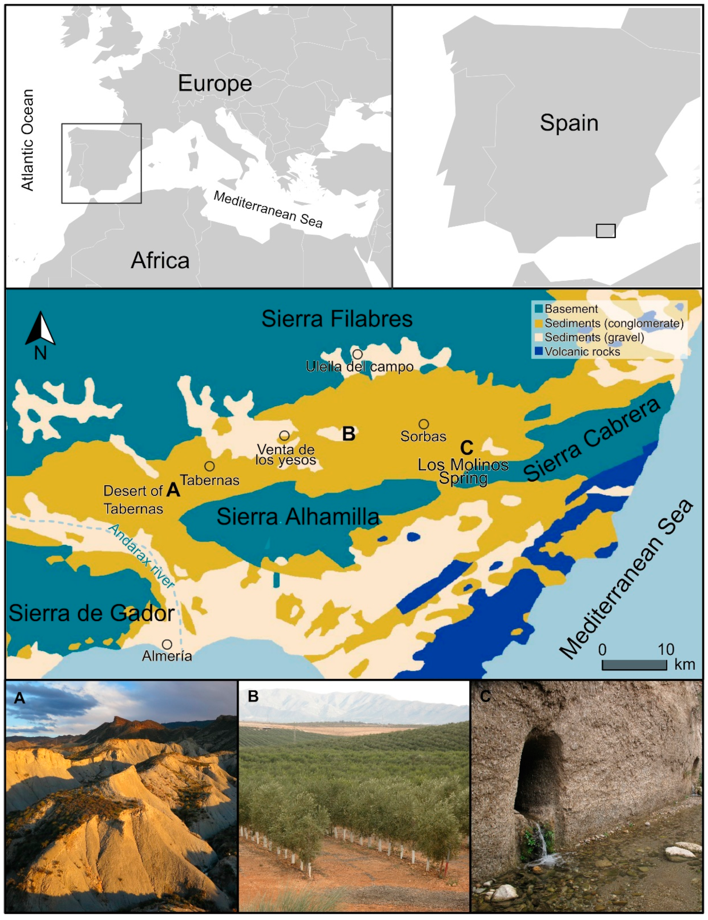
Figure 2.
Temporal evolution of the olive grove surface under irrigation (green surface) (obtained from SIOSE database and photo-interpretation with aerial images from Google Earth) and the water flow of the Los Molinos spring (blue columns) ([35,47], Calaforra, J.M., pers. comm., 15 Dic 2019).

Figure 3.
Temporal and spatial evolution of the olive grove surface in 1956, 1977, 1998, 2004, 2013, and 2019.
Figure 3.
Temporal and spatial evolution of the olive grove surface in 1956, 1977, 1998, 2004, 2013, and 2019.

Figure 4.
(A) Reforestation with pine trees, following the contours of the small reliefs, and irrigation olive orchards in the study area (2004). (B) The same area in 2019, where afforestations have been dismantled and the territory has been levelled (green areas) to facilitate the planting super intensive irrigated olive groves. Map data: Google, DigitalGlobe.

Figure 5.
(A) Map of the surface of the “Alto Aguas” aquifer. Natural groundwater flow to the “Los Molinos” spring. The red dotted line is the water divider, the blue indicates flow lines and spring. (B) Groundwater flow is modified by extractions for intensive irrigation of crops, reducing contributions to the Los Molinos spring.

Table 1.
Data sources, spatial resolution, band numbers and year of the data used in the photointerpretation of olive tree groves.
Table 1.
Data sources, spatial resolution, band numbers and year of the data used in the photointerpretation of olive tree groves.
| Data Source | Spatial Resolution | Band Number | Year |
|---|---|---|---|
| American flight | 1 m/pixel | 1 | 1956 |
| Interministerial flights | 1 m/pixel | 1 | 1977 |
| Andalusian Environmental Information Network (REDIAM) | 0.5 m/pixel | 3 | 1998 |
| Andalusian Environmental Information Network (REDIAM) | 0.5 m/pixel | 3 | 2004 |
| Google EarthTM | 0.5 m/pixel | 3 | 2013 |
| Google EarthTM | 0.5 m/pixel | 3 | 2019 |
© 2020 by the authors. Licensee MDPI, Basel, Switzerland. This article is an open access article distributed under the terms and conditions of the Creative Commons Attribution (CC BY) license (http://creativecommons.org/licenses/by/4.0/).
Share and Cite
MDPI and ACS Style
Martínez-Valderrama, J.; Guirado, E.; Maestre, F.T. Unraveling Misunderstandings about Desertification: The Paradoxical Case of the Tabernas-Sorbas Basin in Southeast Spain. Land 2020, 9, 269. https://doi.org/10.3390/land9080269
AMA Style
Martínez-Valderrama J, Guirado E, Maestre FT. Unraveling Misunderstandings about Desertification: The Paradoxical Case of the Tabernas-Sorbas Basin in Southeast Spain. Land. 2020; 9(8):269. https://doi.org/10.3390/land9080269
Chicago/Turabian StyleMartínez-Valderrama, Jaime, Emilio Guirado, and Fernando T. Maestre. 2020. "Unraveling Misunderstandings about Desertification: The Paradoxical Case of the Tabernas-Sorbas Basin in Southeast Spain" Land 9, no. 8: 269. https://doi.org/10.3390/land9080269
Note that from the first issue of 2016, this journal uses article numbers instead of page numbers. See further details here.