Reconstructing the Ancient Route Network in Pergamon’s Surroundings

Abstract
1. Introduction
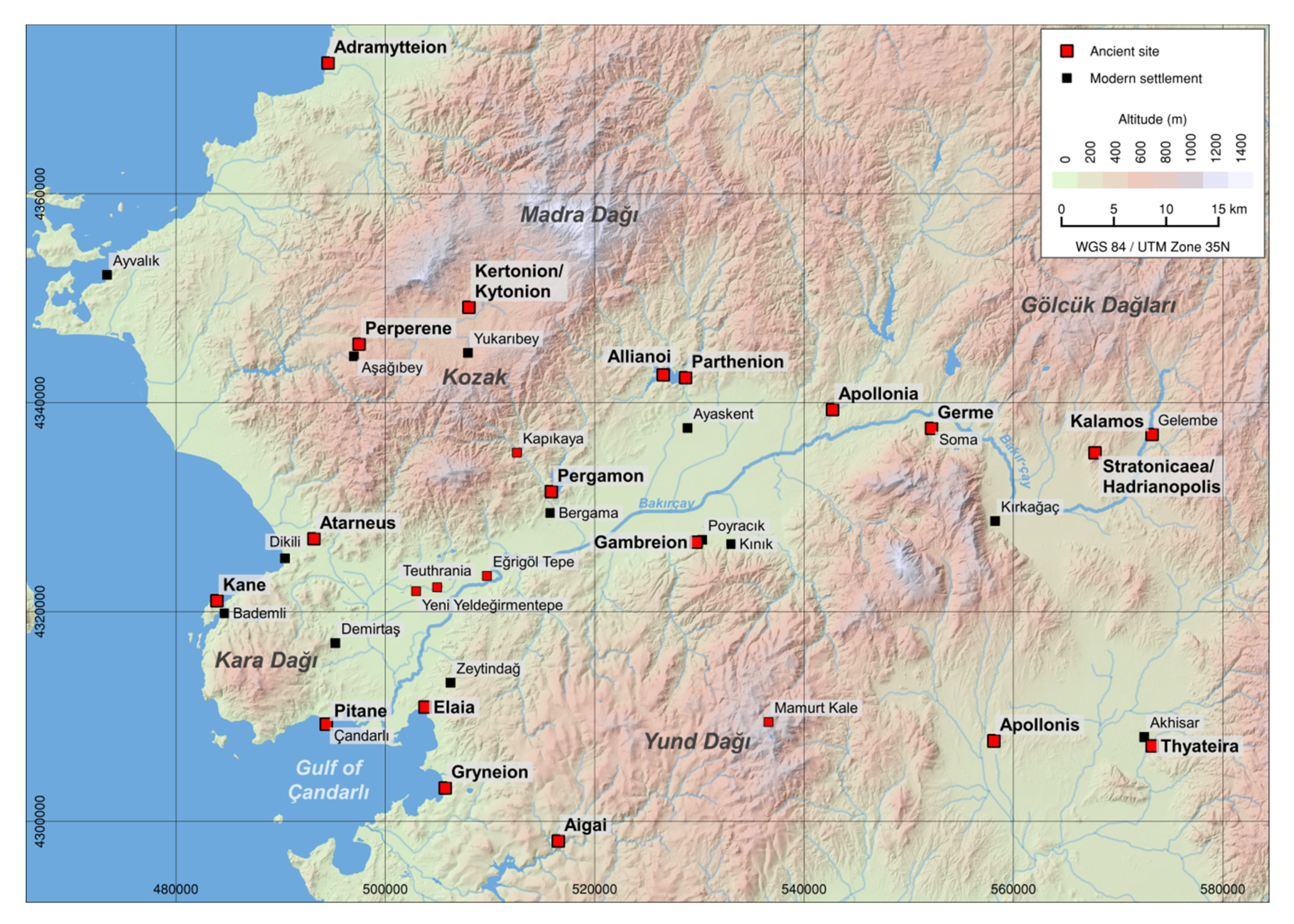
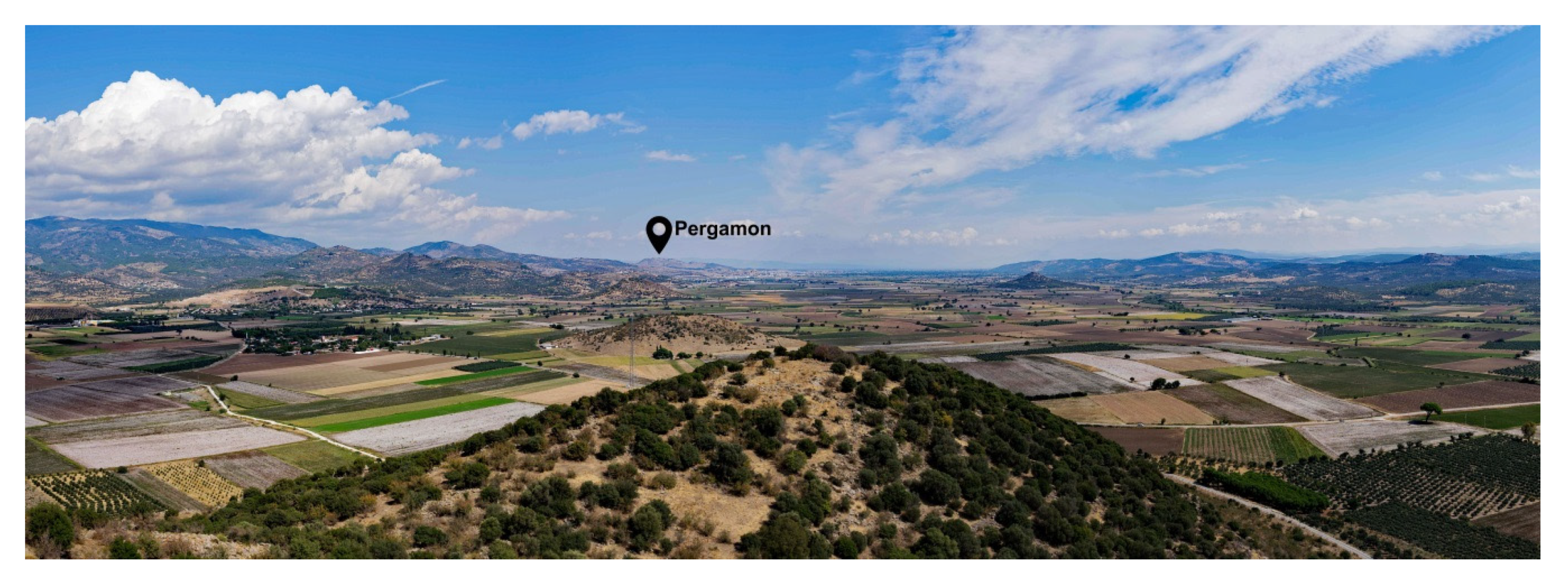
2. Study Area
3. Objectives
4. Methods
4.1. Archeological Data
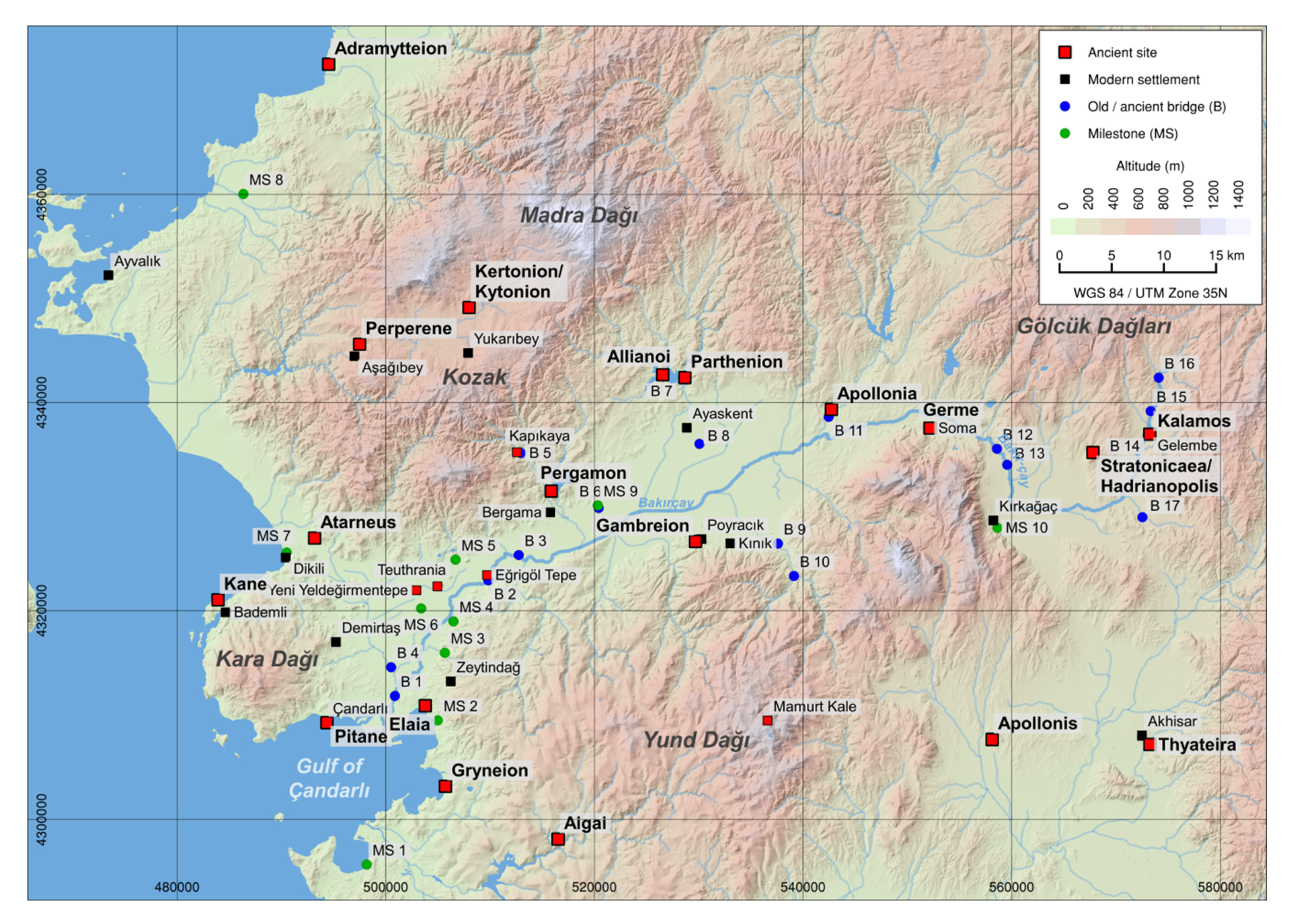
4.1.1. Archeological Remains of Ancient Roads
4.1.2. Archeological Remains of Ancient Bridges
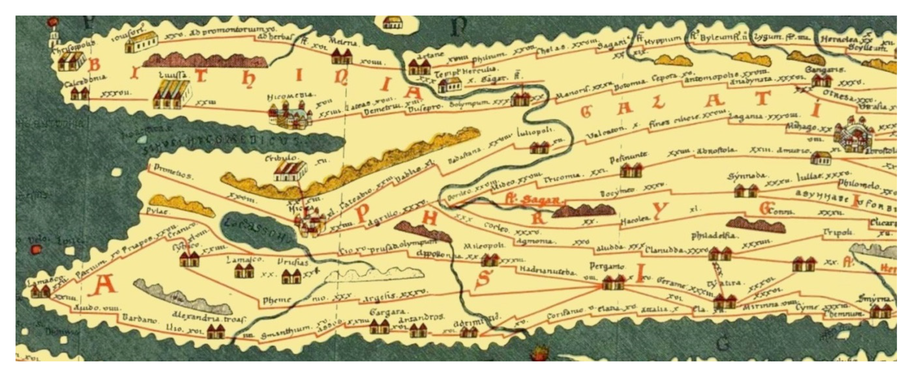
4.2. Additional Sources and Data
4.3. Least-Cost Path Analysis
4.3.1. Topographic Data
4.3.2. Software and Calculations
5. Reconstruction of the Route Network in the Surroundings of Pergamon
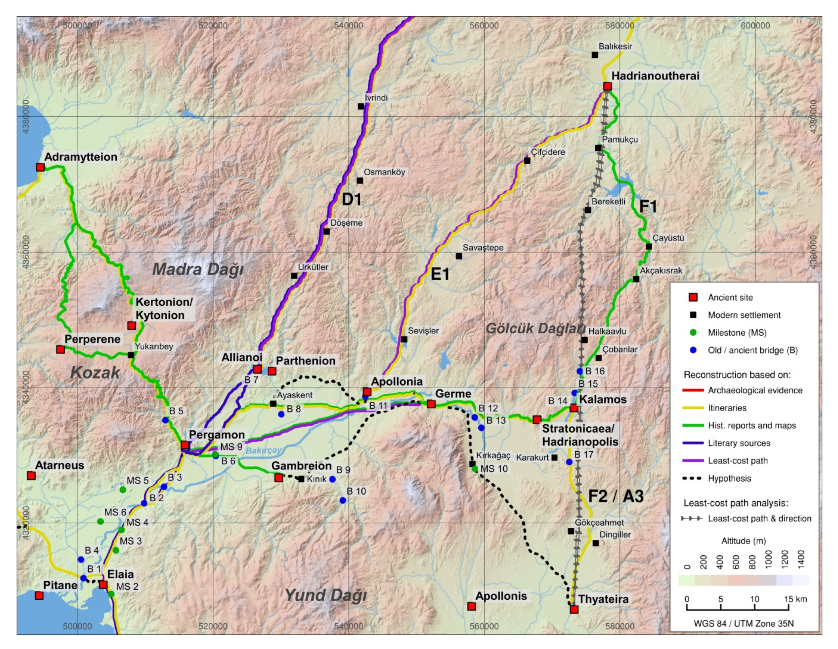
5.1. Route A Adramytteion – Thyateira
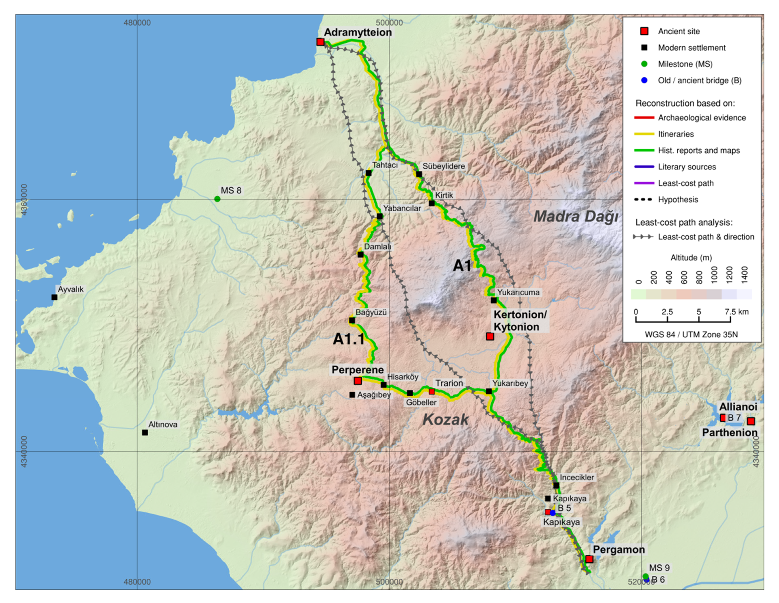
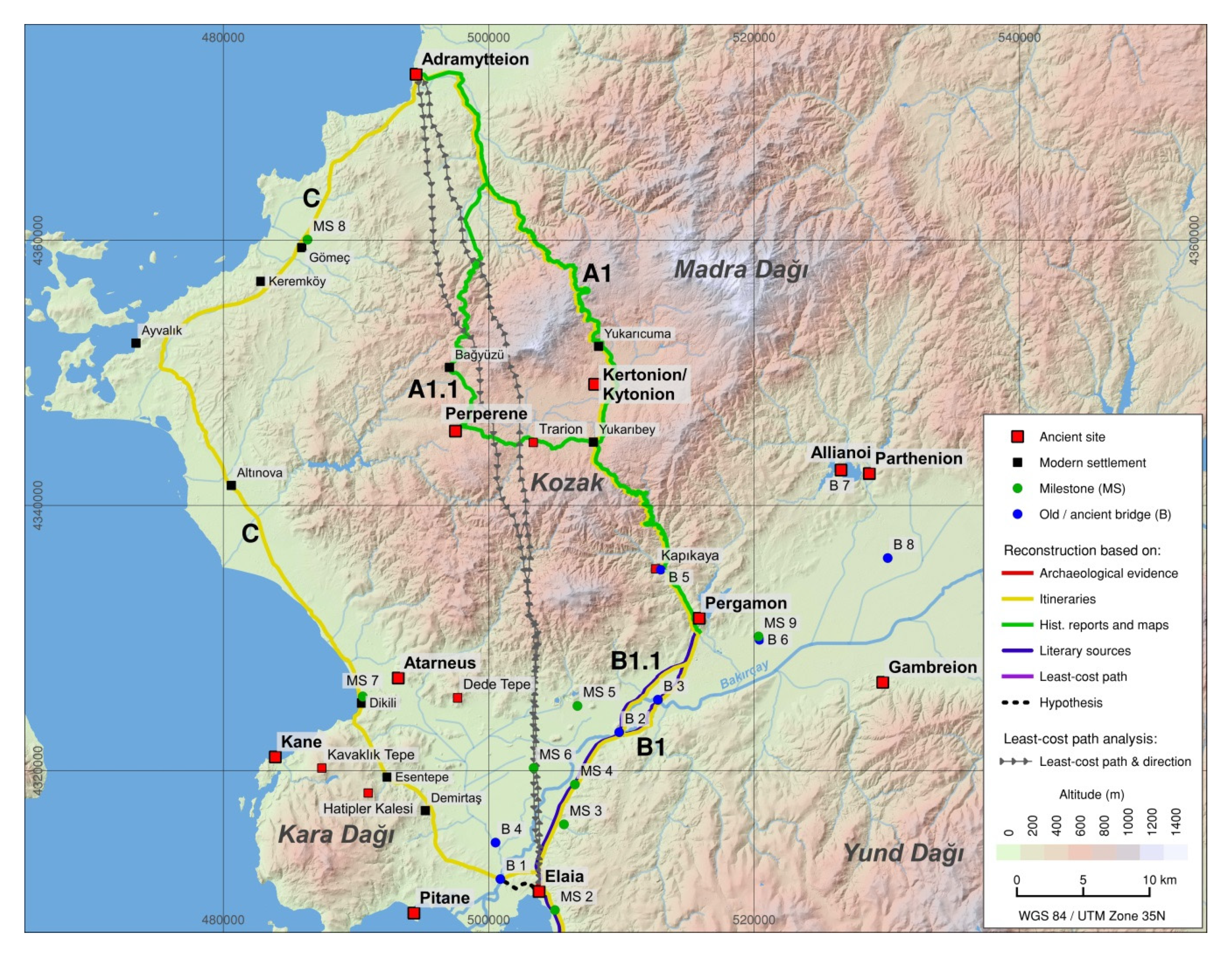
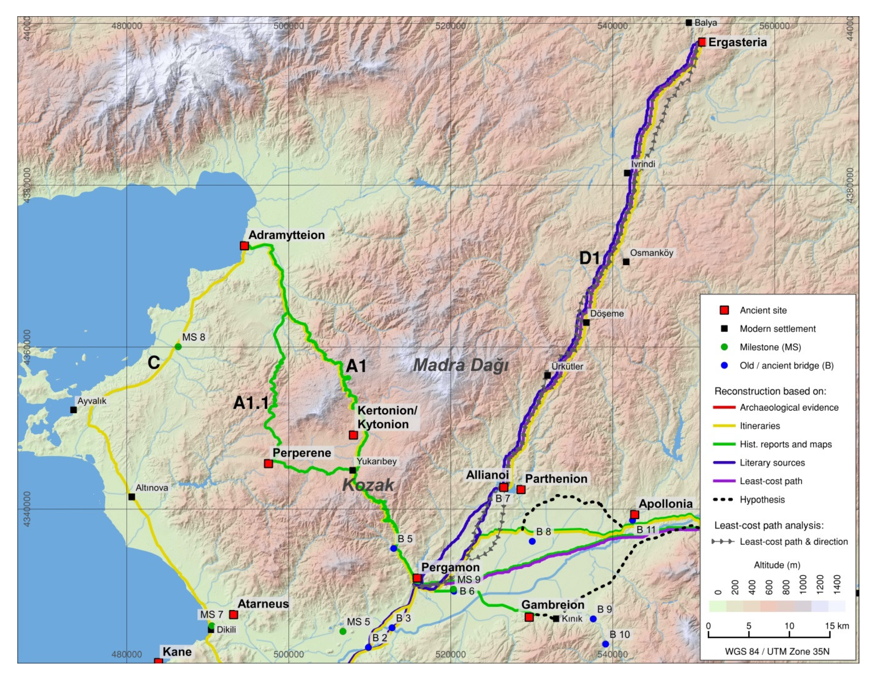
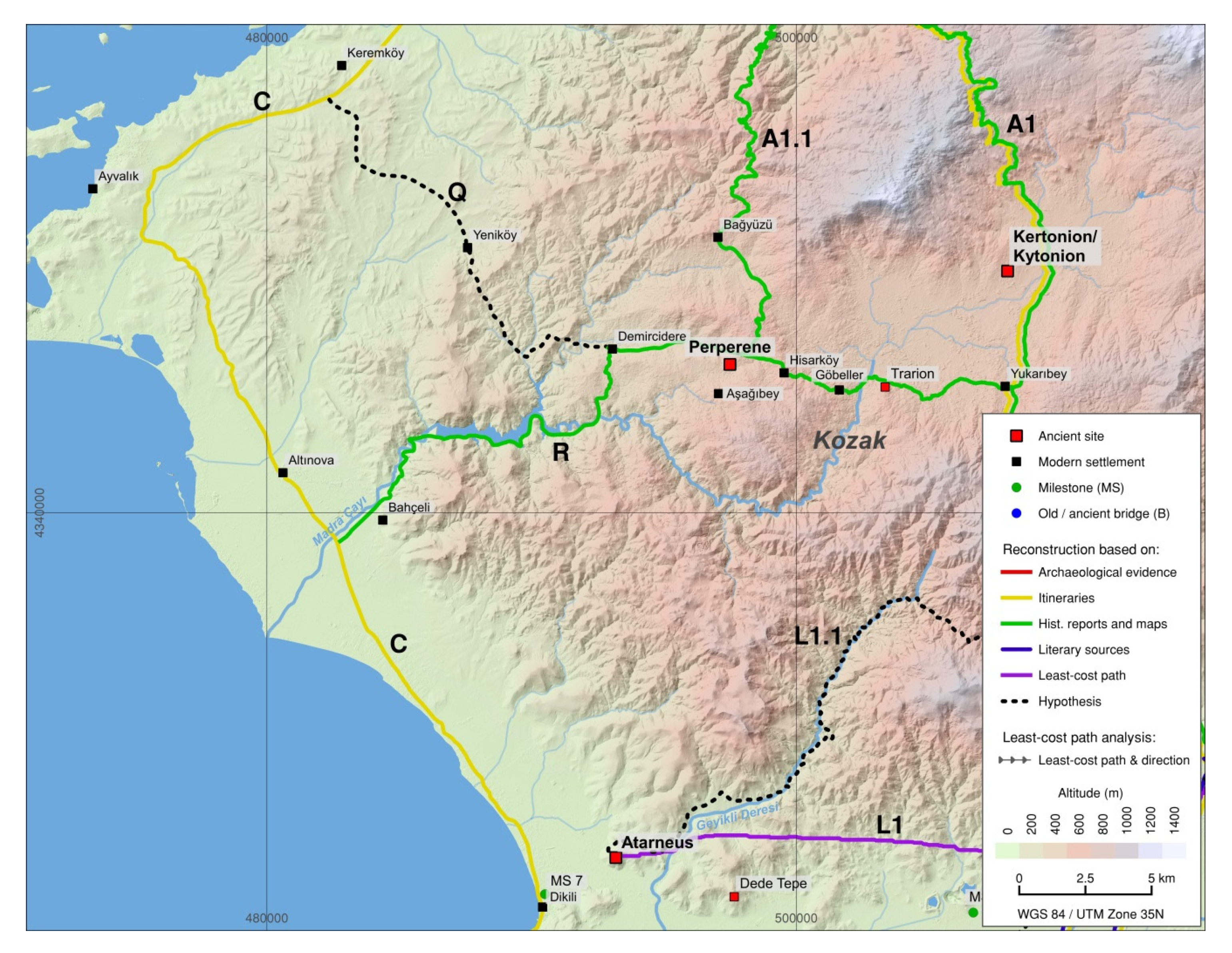
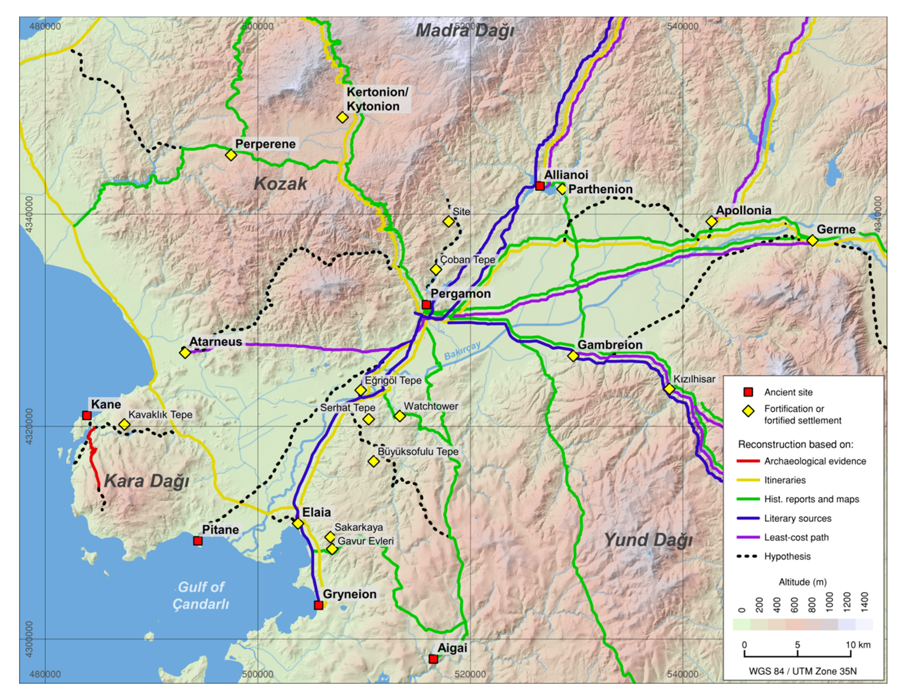
5.1.1. Route A1 Adramytteion – Pergamon (via Kytonion)
Route A1.1 Adramytteion – Pergamon (via Perperene)
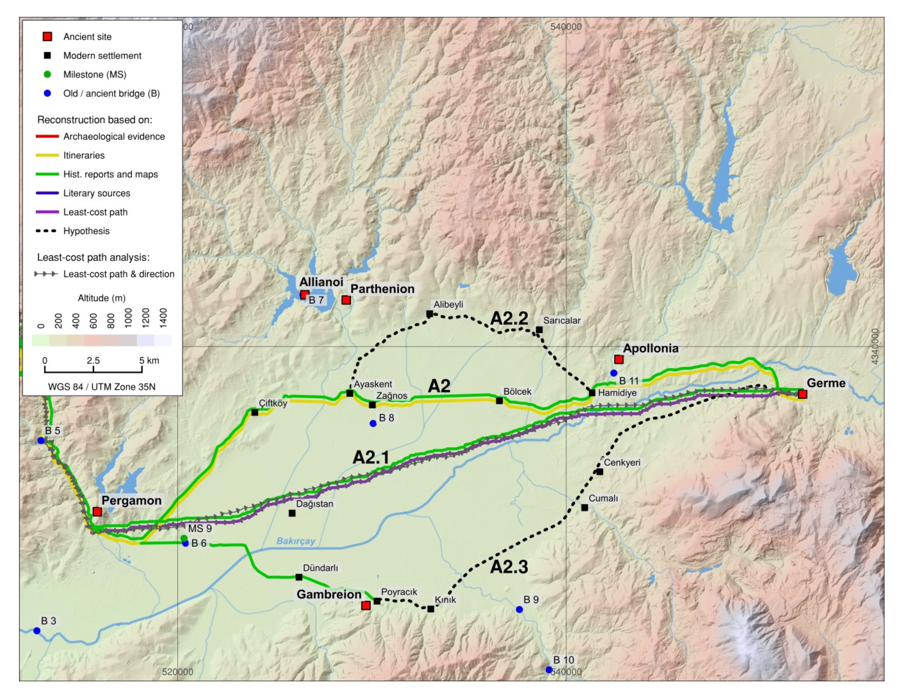
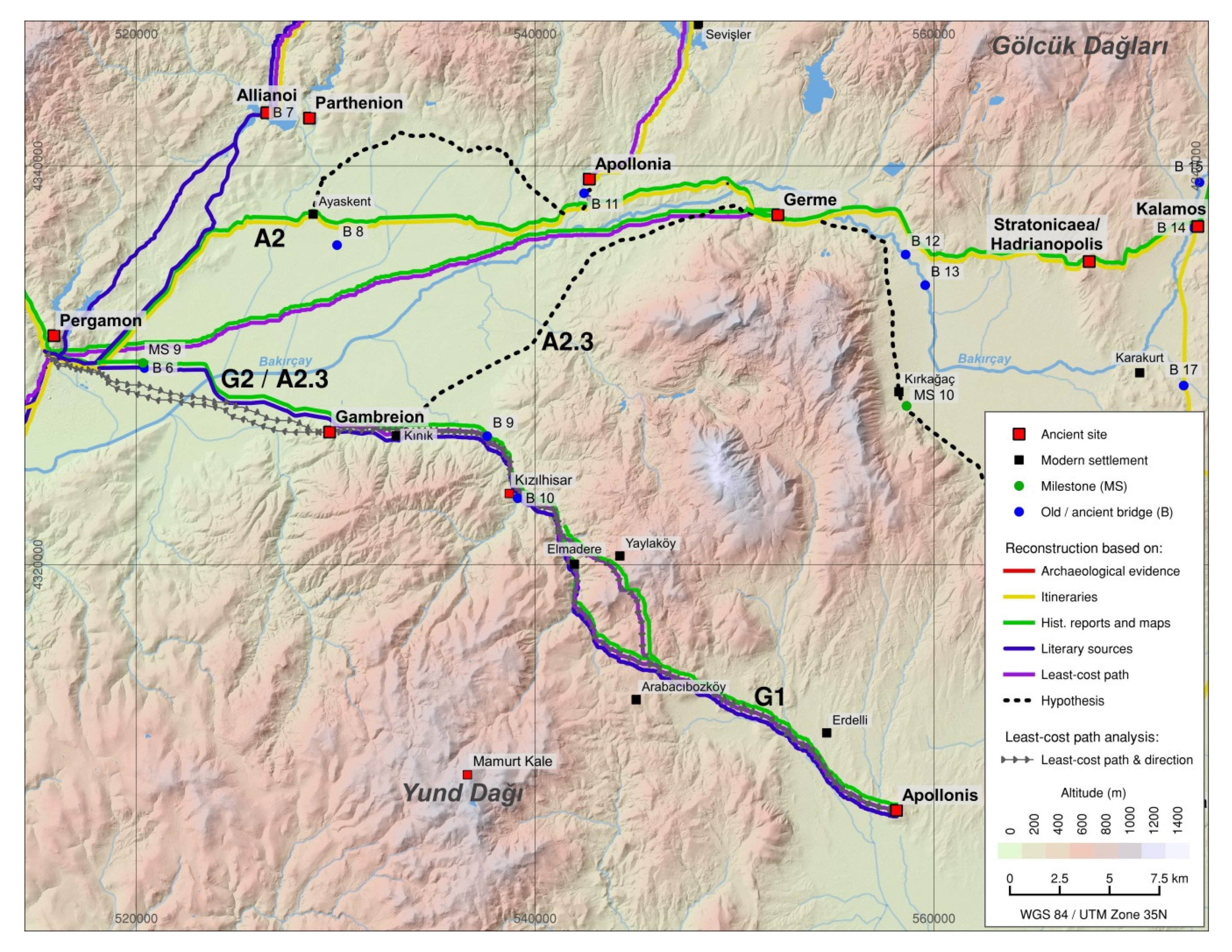
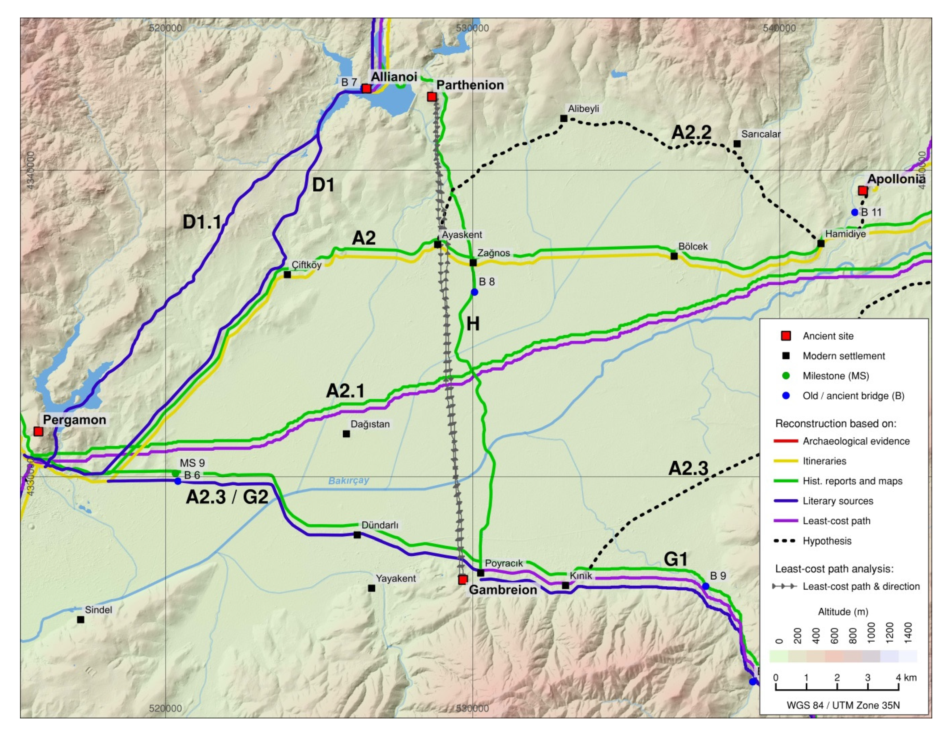
5.1.2. Route A2 Pergamon – Germe (via Apollonia)
Route A2.1 Pergamon – Germe (through the Plain)
Route A2.2 Pergamon – Germe (Along the Northern Edge of the Eastern Lower Bakırçay Valley)
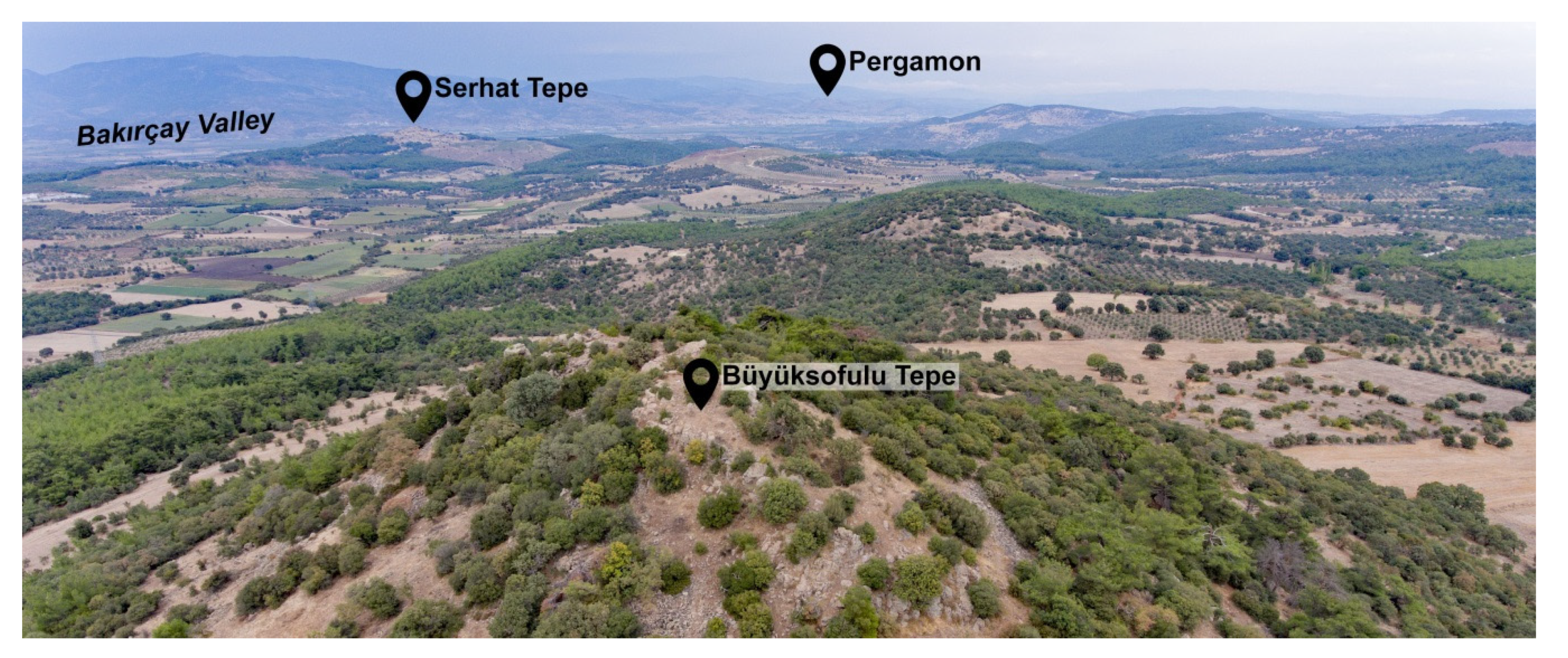
Route A2.3 Pergamon – Germe (Along the Southern Edge of the Eastern Lower Bakırçay Valley)
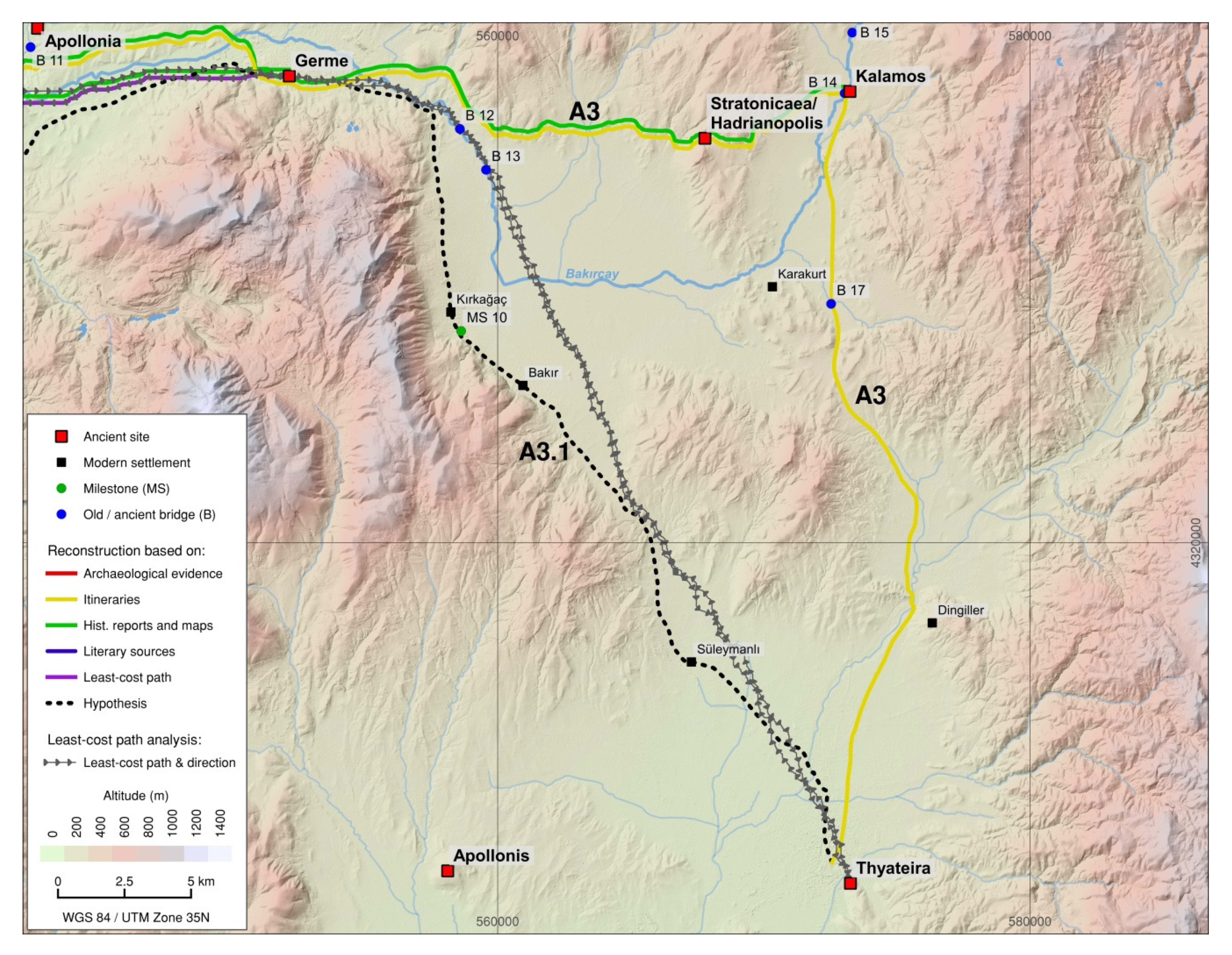
5.1.3. Route A3 Germe – Thyateira (via Stratonicaea/Hadrianopolis and Kalamos)
Route A3.1 Germe – Thyateira (via Kirkağaç)
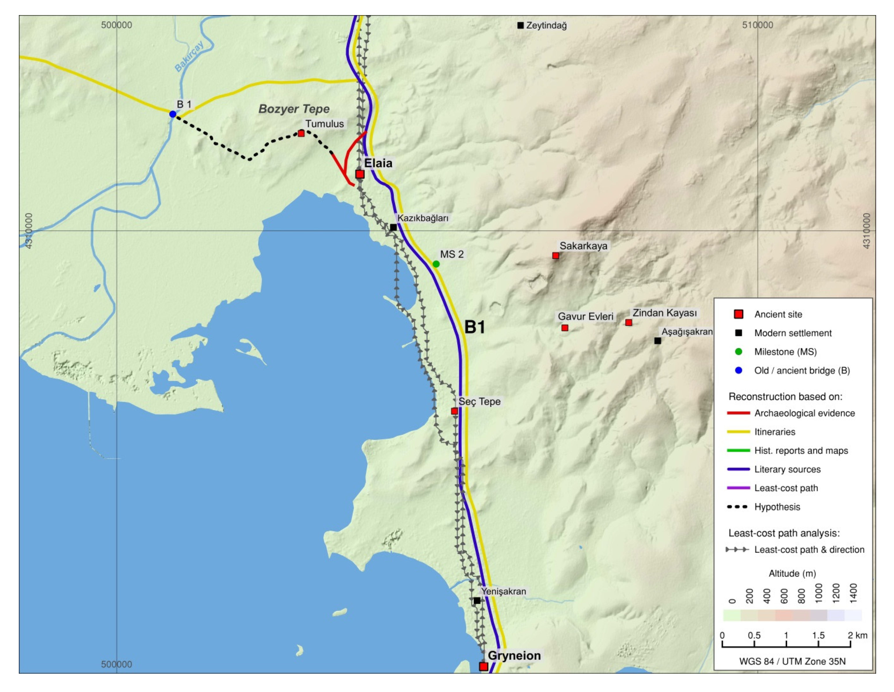
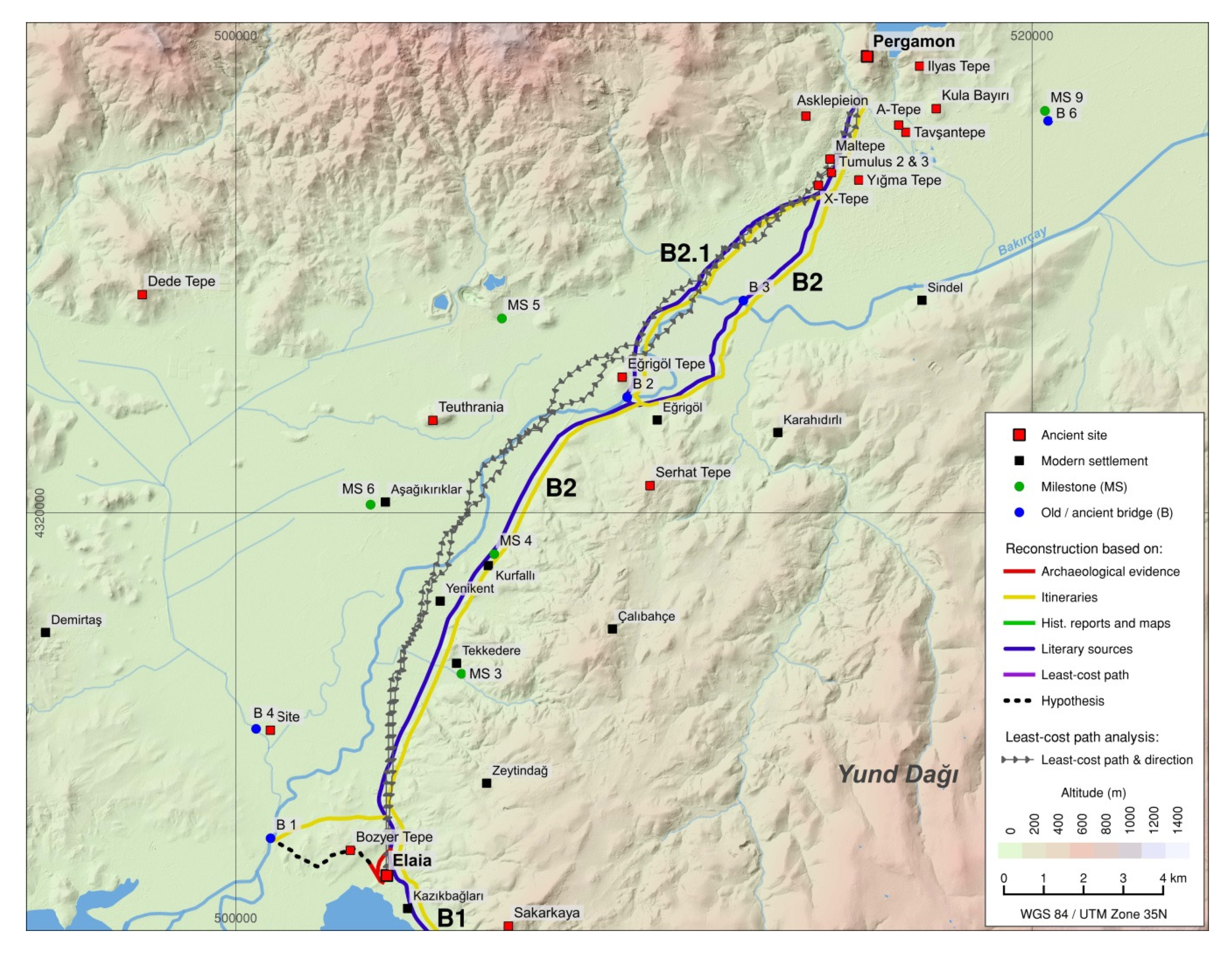
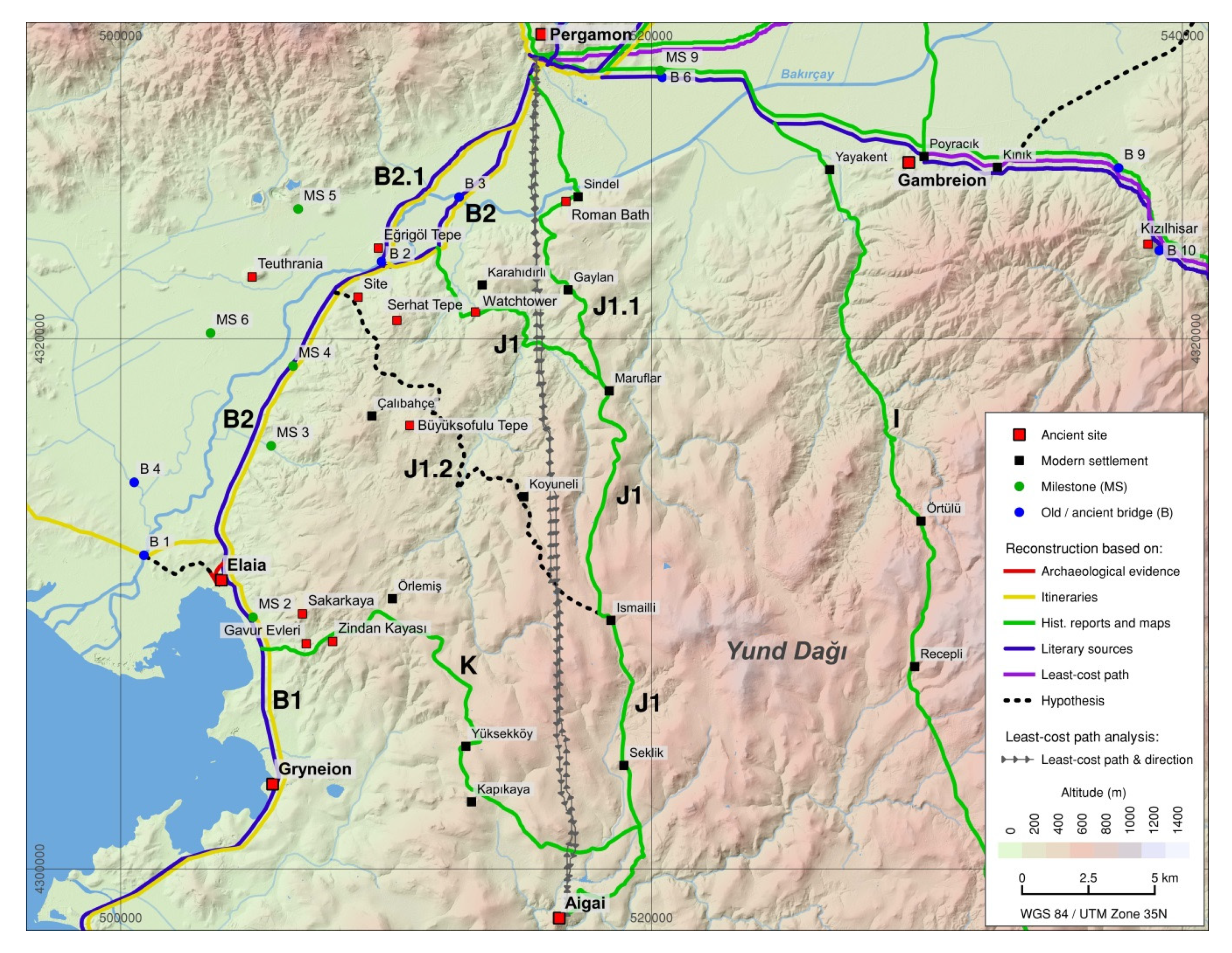
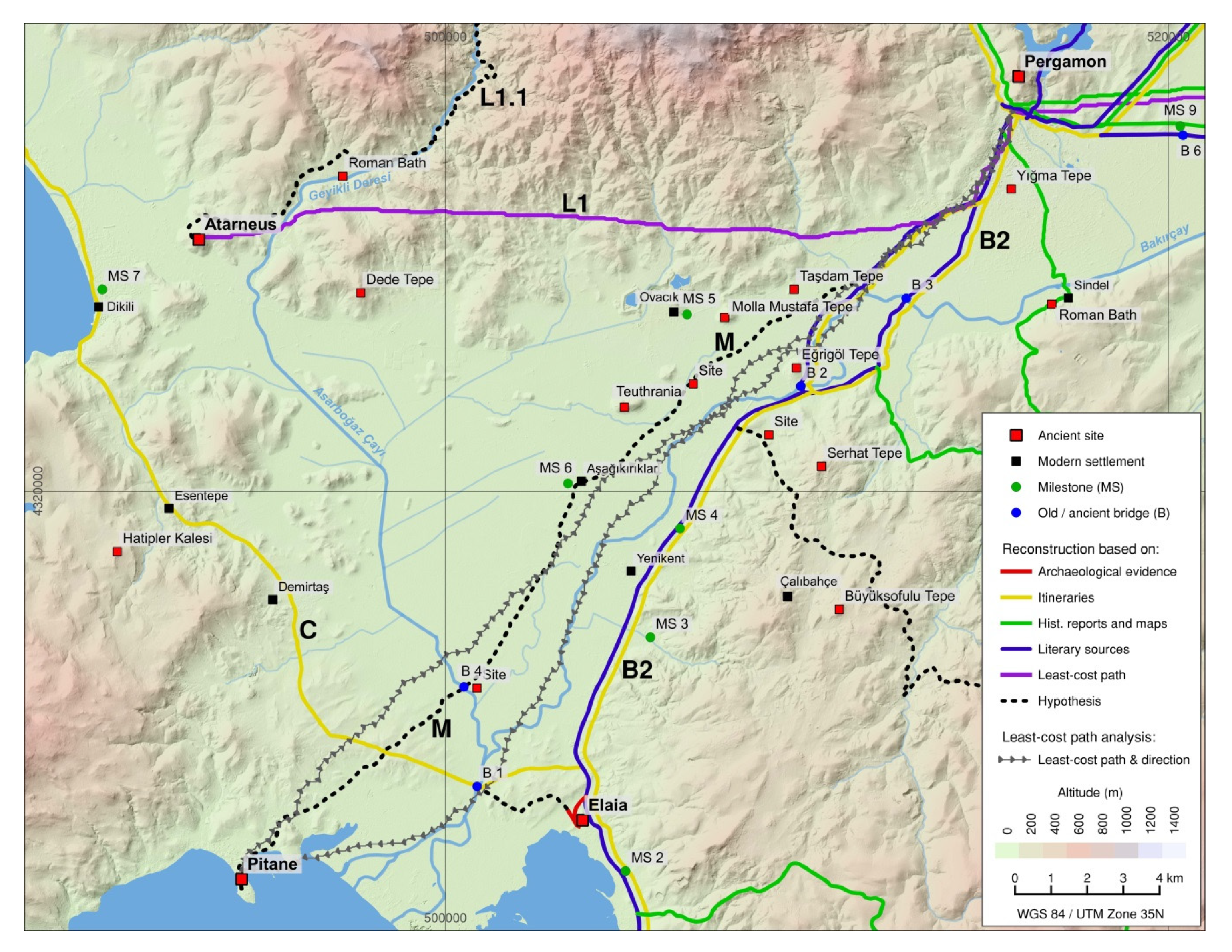
5.2. Route B (Ephesus –) Gryneion – Pergamon (via Elaia)
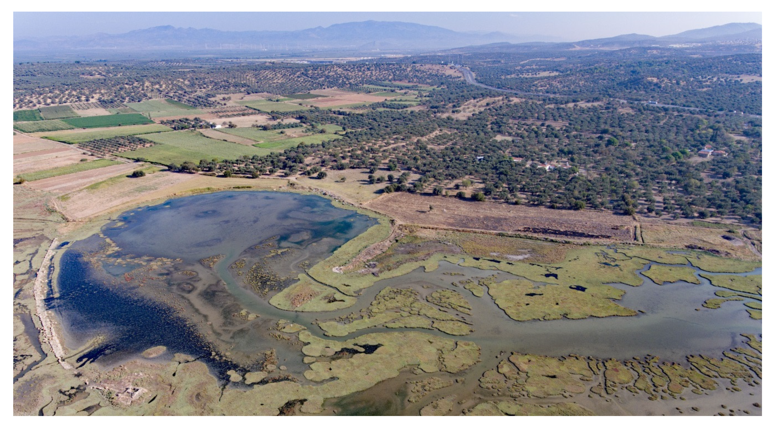
5.2.1. Route B1 Gryneion – Elaia and around Elaia
5.2.2. Route B2 Elaia – Pergamon (via Bridge 3)
Route B2.1 Elaia – Pergamon (via Bridge 2)
5.3. Route C Adramytteion – Elaia
5.4. Route D (Cyzicus –) Ergasteria – Pergamon
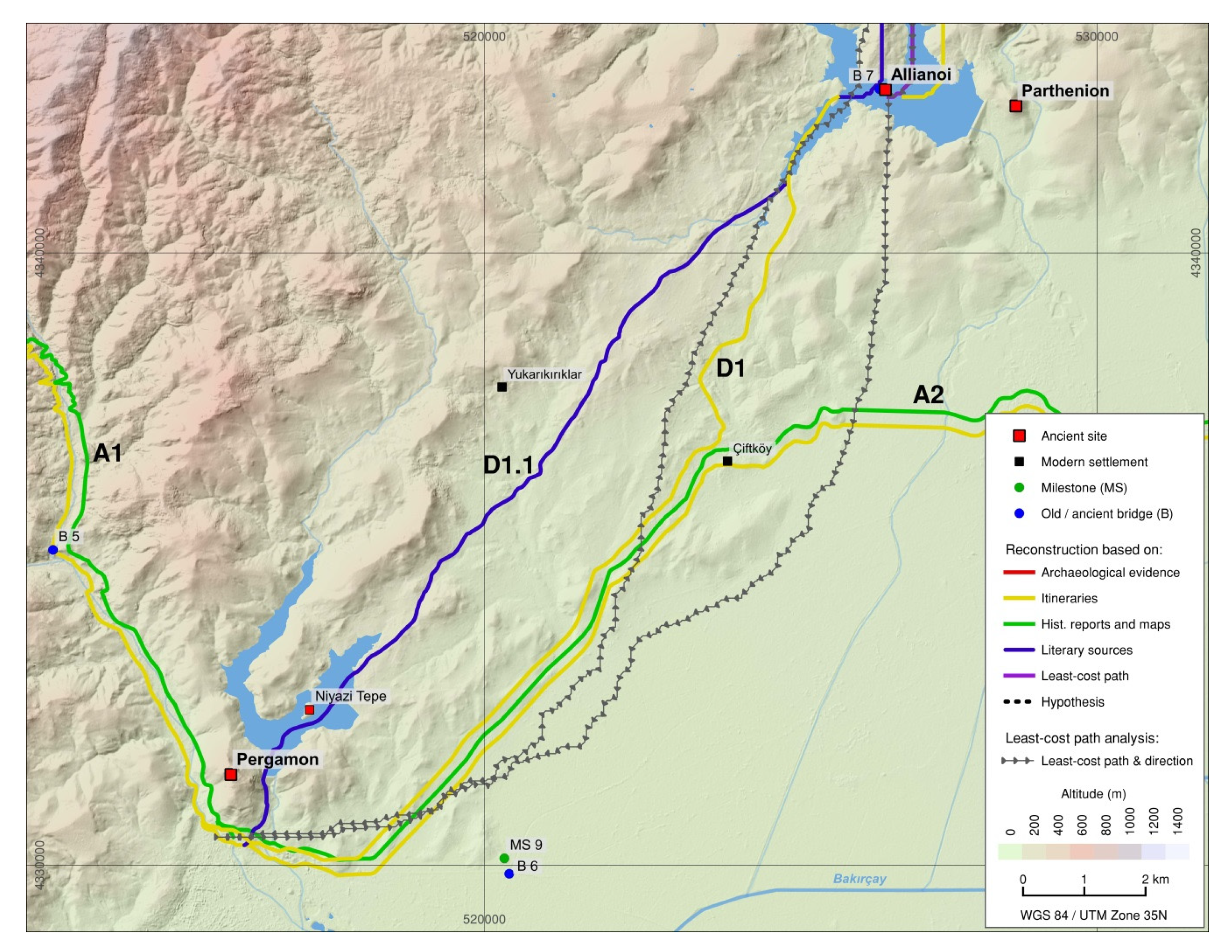
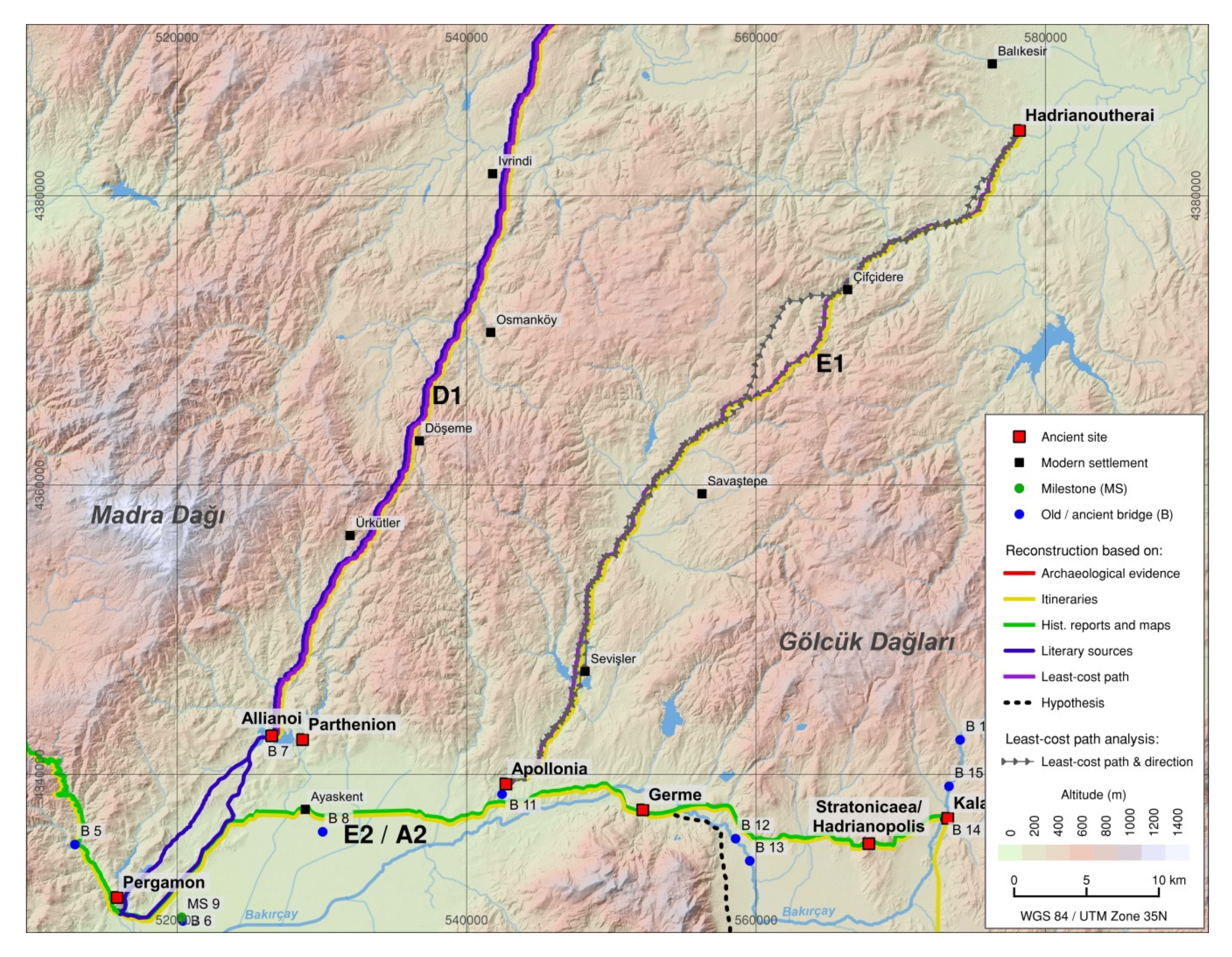
5.4.1. Route D1 Ergasteria – Pergamon (via Parthenion and Allianoi through the Bakırçay Valley)
Route D1.1 Ergasteria – Pergamon (via Parthenion and Allianoi through the Kestel Creek Valley)
5.5. Route E Hadrianoutherai – Pergamon
5.5.1. Route E1 Hadrianoutherai – Apollonia
5.5.2. Route E2 Apollonia – Pergamon (=A2)
5.6. Route F Hadrianoutherai – Thyateira
5.6.1. Route F1 Hadrianoutherai – Kalamos
5.6.2. Route F2 Kalamos – Thyateira (=A3)
5.7. Route G (Sardis –) Apollonis – Pergamon
5.7.1. Route G1 Apollonis – Gambreion
5.7.2. Route G2 Gambreion – Pergamon
5.8. Route H Parthenion – Gambreion
5.9. Route I Magnesia – Pergamon
5.10. Route J Aigai – Pergamon
5.10.1. Route J1 Aigai – Pergamon
Route J1.1 Aigai – Pergamon (Eastern Route)
Route J1.2 Aigai – Pergamon (Western Route)
5.11. Route K Aigai – Coastal Road (Elaia)
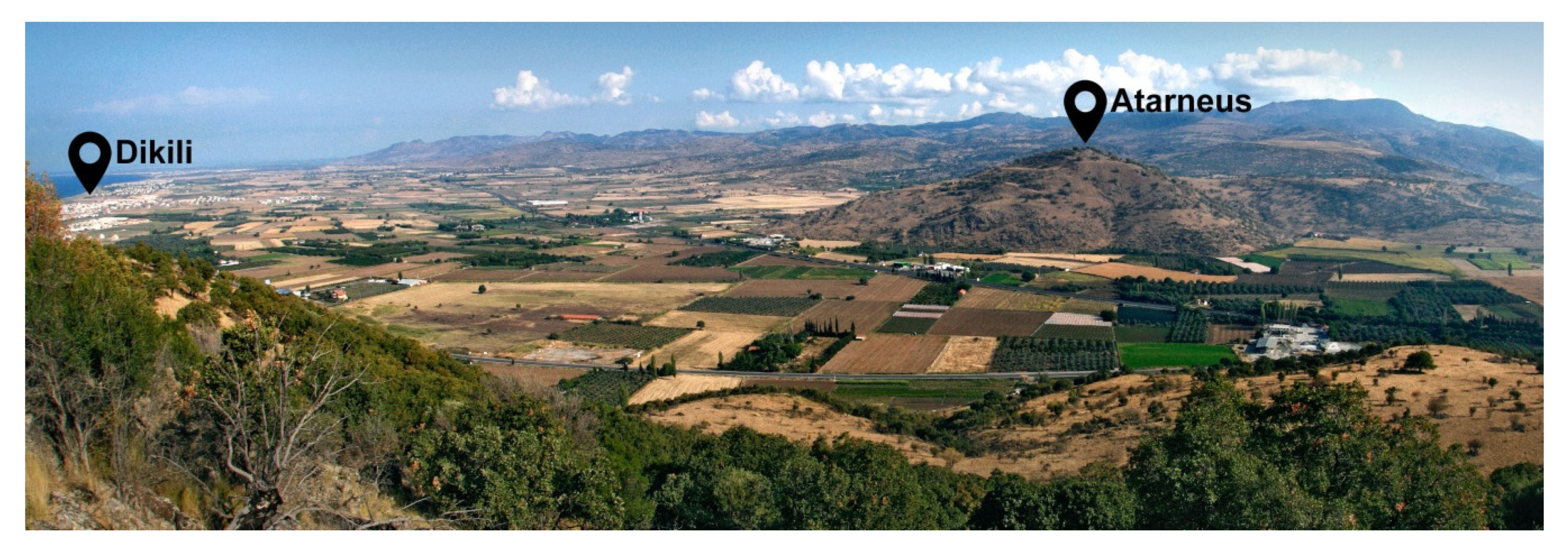
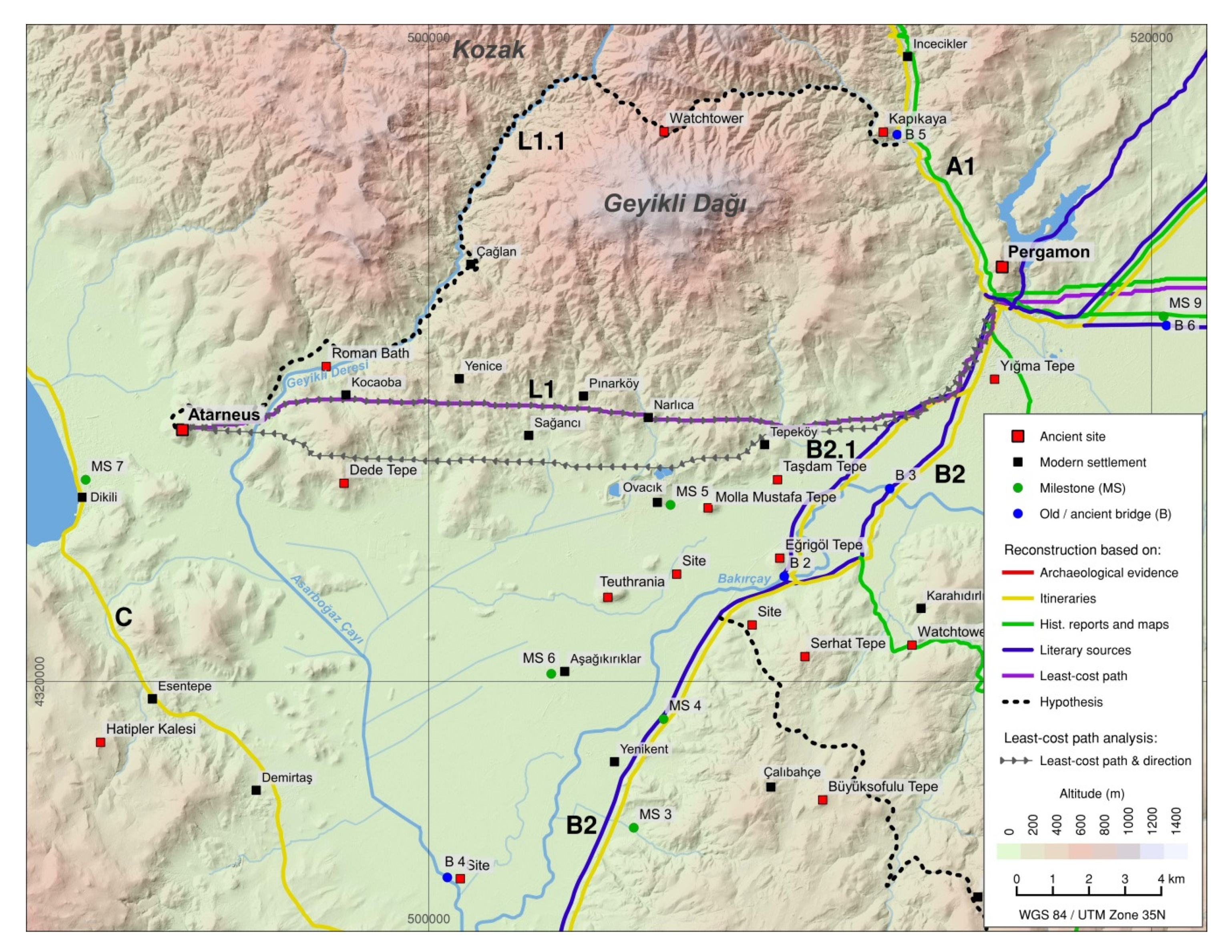
5.12. Route L Atarneus – Pergamon
5.12.1. Route L1 Atarneus – Pergamon
Route L1.1 Atarneus – Pergamon (through the Kozak Mountains)
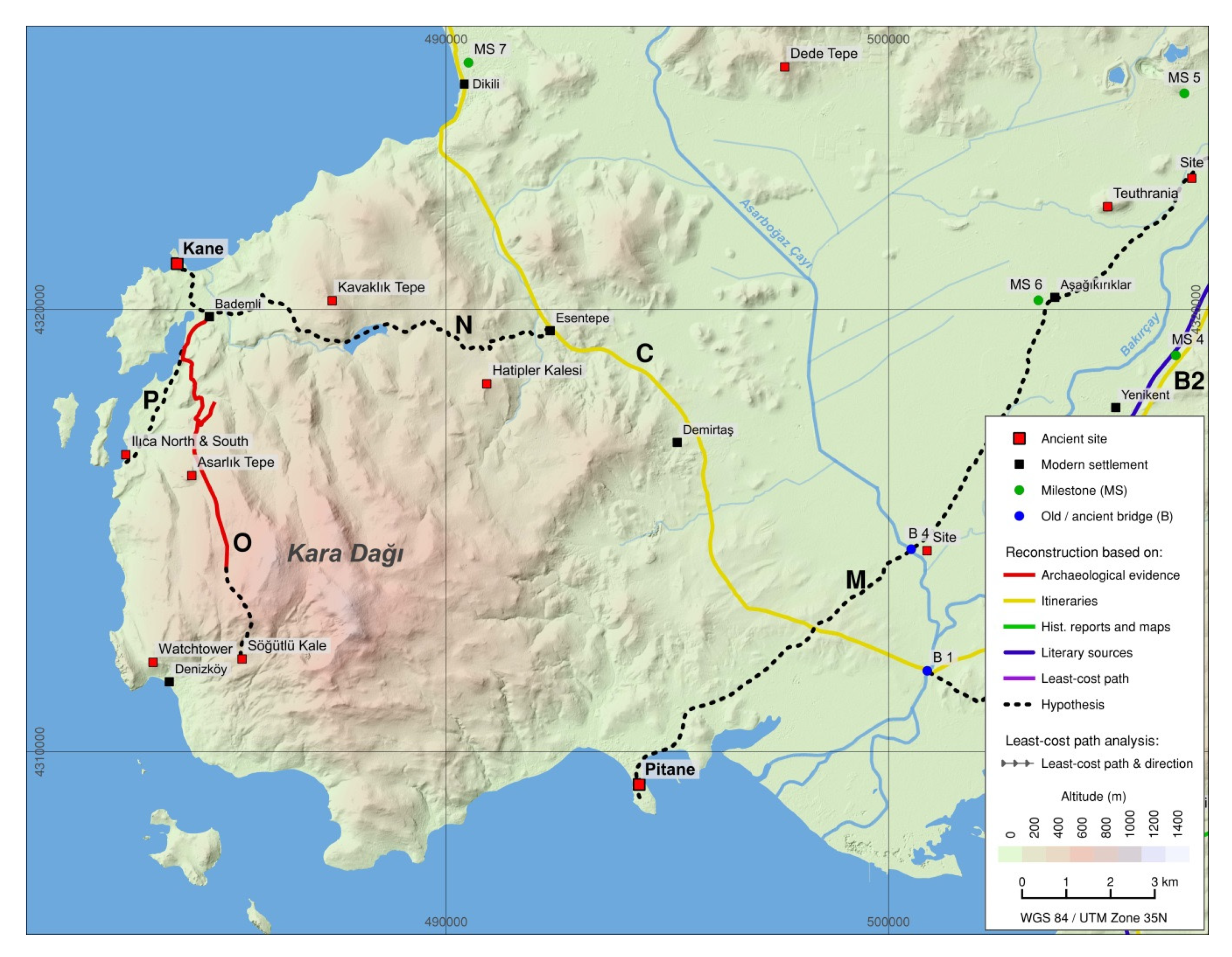
5.13. Route M Pitane – Pergamon
5.14. Route N Kane – Coastal Road (C Adramytteion – Elaia)
5.15. Route O Kane – Kara Dağı Mountains
5.16. Route P Kane – Ilıca North and Ilıca South
5.17. Route Q Perperene – Coastal Road (Near Ayvalık)
5.18. Route R Perperene – Coastal Road (Near Altınova)
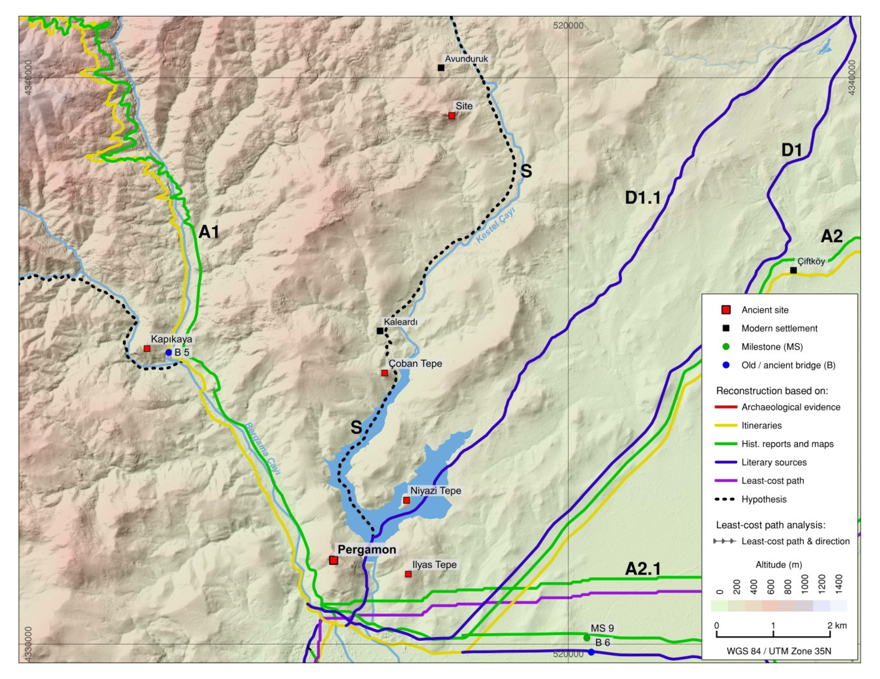
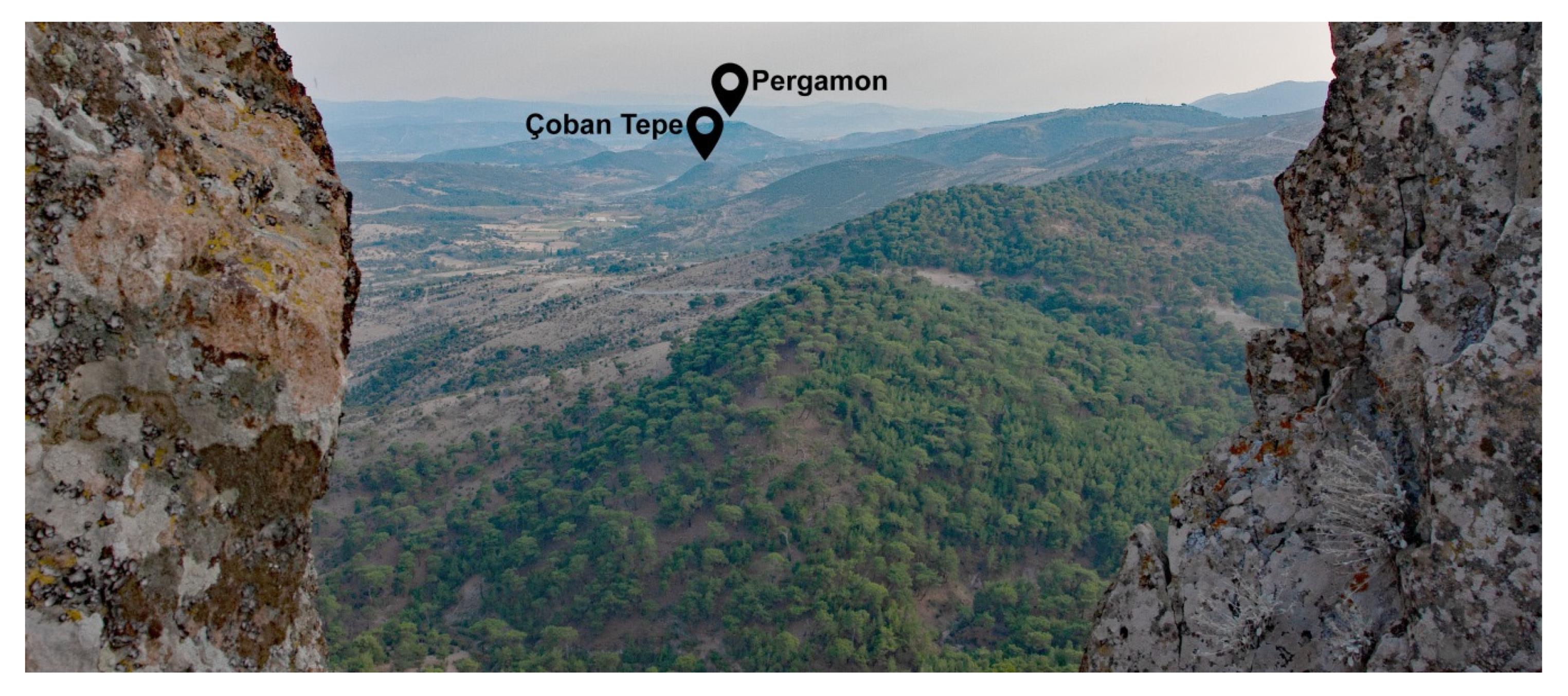
5.19. Route S Kozak Mountains and Kestel Creek Valley – Pergamon
6. Discussion
6.1. Route Network as Element of Socio-Economic Processes
6.2. Route Network as Element of Cultural Processes
6.3. Control and Securing of the Route Network
7. Conclusions
Funding
Acknowledgments
Conflicts of Interest
References
- Pirson, F. Elaia, der (maritime) Satellit Pergamons. In Häfen und Hafenstädte im östlichen Mittelmeerraum von der Antike bis in byzantinische Zeit: Neue Entdeckungen und aktuelle Forschungsansätze: Istanbul, 30.05.-01.06.2011 = Harbors and Harbor Cities in the Eastern Mediterranean from Antiquity to the Byzantine period: Recent Discoveries and Current Approaches; Ladstätter, S., Pirson, F., Schmidts, T., Eds.; Ege Yayınları: Istanbul, Turkey, 2014; pp. 339–356. ISBN 6054701622. [Google Scholar]
- Pirson, F.; Ateş, G.; Bartz, M.; Brückner, H.; Feuser, S.; Mania, U.; Meier, L.; Seeliger, M. Elaia: eine aiolische Polis im Dienste der hellenistischen Residenzstadt Pergamon. In Urbane Strukturen und bürgerliche Identität im Hellenismus; Matthaei, A., Zimmermann, M., Eds.; Springer: Berlin/Heidelberg, Germany, 2015; pp. 22–55. ISBN 978-3-938032-55-8. [Google Scholar]
- Pirson, F. Das Territorium der hellenistischen Residenzstadt Pergamon: Herrschaftlicher Anspruch als raumbezogene Strategie. In Räume der Stadt: Von der Antike Bis Heute; Jöchner, C., Ed.; Reimer: Berlin, Germany, 2008; pp. 27–50. ISBN 3496013931. [Google Scholar]
- Külzer, A. Von Assos nach Pergamon und Ephesos: Betrachtungen zu den Straßen Westkleinasiens in römischer und byzantinischer Zeit. In Assos: Neue Forschungsergebnisse zur Baugeschichte und Archäologie der südlichen Troas; Arslan, N., Mohr, E.-M., Rheidt, K., Eds.; Dr. Rudolf Habelt GmbH: Bonn, Germany, 2016; pp. 185–204. ISBN 9783774939516. [Google Scholar]
- Tozan, M. Pergamon’un Yolları: Antikçağ’dan Bizans’a Bakırçay (Kaikos) Havzası’nın Yol Sistemi. Tar. Incel. Derg. 2017, 32, 531–563. [Google Scholar] [CrossRef][Green Version]
- Schneider, S.; Matthaei, A.; Schlöffel, M.; Meyer, C.; Kronwald, M.; Pint, A.; Schütt, B. A geoarchaeological case study in the chora of Pergamon, western Turkey, to reconstruct the late Holocene landscape development and settlement history. Quat. Int. 2015, 367, 62–76. [Google Scholar] [CrossRef]
- Schneider, S.; Bebermeier, W.; Schütt, B. Geoarchäologische Untersuchungen im westlichen Kaikostal—Erste Ergebnisse. In Pergamon: Bericht über die Arbeiten in der Kampagne 2009; Pirson, F., Ed.; Deutsches Archäologisches Institut: Berlin, Germany, 2010; pp. 183–188. [Google Scholar]
- Schneider, S.; Matthaei, A.; Bebermeier, W.; Schütt, B. Late Holocene human–environmental interactions in the Eastern Mediterranean: Settlement history and paleogeography of an ancient Aegean hill-top settlement. Quat. Int. 2014, 324, 84–98. [Google Scholar] [CrossRef]
- Schneider, S.; Nykamp, M.; Matthaei, A.; Bebermeier, W.; Schütt, B. Alluvial geoarchaeology of a small drainage basin in western Anatolia: Late Holocene landscape development and the question of the mouth of the Paleo-Bakırçay. Quat. Int. 2013, 312, 84–95. [Google Scholar] [CrossRef]
- Dörpfeld, W. Die Arbeiten zu Pergamon 1908–1909. Mitt. Dtsch. Archäol. Inst. Athen. Abt. 1910, 1910, 345–400. [Google Scholar]
- Dörpfeld, W. Die Arbeiten zu Pergamon 1910–1911. Mitt. Dtsch. Archäol. Inst. Athen. Abt. 1912, 1912, 233–276. [Google Scholar]
- Von Diest, W. Von Pergamon über den Dindymos zum Pontus; Justus Perthes: Gotha, Germany, 1889. [Google Scholar]
- Lolling, H.G. Atarneus. Mitt. Dtsch. Archäol. Inst. Athen. Abt. 1879, 1879, 1–10. [Google Scholar]
- Philippson, A. Zur Geographie der Unteren Kaikos-Ebene in Kleinasien. Hermes 1911, 46, 254–260. [Google Scholar]
- Bittel, K. Zur ältesten Besiedlungsgeschichte der unteren Kaikos-Ebene. In Kleinasien und Byzanz: Gesammelte Aufsätze; Bittel, K., Ed.; Springer: Berlin, Germany, 1950; pp. 10–29. [Google Scholar]
- Laufer, E. Der Survey auf der Kane-Halbinsel (Kane Regional Harbour Survey). In Pergamon: Bericht über die Arbeiten in der Kampagne 2015; Pirson, F., Ed.; Deutsches Archäologisches Institut: Berlin, Germany, 2016; pp. 174–185. [Google Scholar]
- Feuser, S.; Laufer, E. Der Survey auf der Kane-Halbinsel (Kane Regional Harbour Survey). In Pergamon: Bericht über die Arbeiten in der Kampagne 2017; Pirson, F., Ed.; Deutsches Archäologisches Institut: Berlin, Germany, 2018; pp. 150–167. [Google Scholar]
- Zimmermann, M. Chora von Pergamon: Abschlussbericht des Umlandsurveys 2011. In Pergamon: Bericht über die Arbeiten in der Kampagne 2011; Pirson, F., Ed.; Deutsches Archäologisches Institut: Berlin, Germany, 2012; pp. 208–218. [Google Scholar]
- Schuchhardt, C. Historische Topographie der Landschaft. In Stadt und Landschaft; Conze, A., Ed.; Reimer: Berlin, Germany, 1912/13; pp. 61–143. [Google Scholar]
- Feuser, S. Elaia und sein Umland. In Altertümer von Pergamon; Pirson, F., Ed.; Universitätsbibliothek Heidelberg: Heidelberg, Germany, 1890; (in prep.). [Google Scholar]
- Philippson, A. Reisen und Forschungen im westlichen Kleinsasien. 1. Heft. Einleitung—Das westliche Mysien und die pergamenische Landschaft; Justus Perthes: Gotha, Germany, 1910. [Google Scholar]
- Pirson, F. Pergamon: Bericht über die Arbeiten in der Kampagne 2009. Archäol. Anz./Dtsch. Archäol. Inst. 2010, 2, 139–236. [Google Scholar]
- Ludwig, B.; Aksan, Z.M.; Pirson, F. Die Arbeiten des Umland-Surveys 2019. In Pergamon: Bericht über die Arbeiten in der Kampagne 2019; Pirson, F., Ed.; Deutsches Archäologisches Institut: Berlin, Germany, 2020; (in prep.). [Google Scholar]
- Ludwig, B. Die Arbeiten des Umland-Surveys 2018. In Pergamon: Bericht über die Arbeiten in der Kampagne 2018; Pirson, F., Ed.; Deutsches Archäologisches Institut: Berlin, Germany, 2019; pp. 113–126. [Google Scholar]
- Berlet, O. Stadt und Landschaft; Conze, A., Ed.; Reimer: Berlin, Germany, 1912. [Google Scholar]
- Graeber, F. Die Wasserleitungen. In Stadt und Landschaft; Conze, A., Ed.; Reimer: Berlin, Germany, 1912; pp. 365–412. [Google Scholar]
- Rheidt, K. Chliara. Ein Beitrag zur spätbyzantinischen Topographie der pergamenischen Landschaft. Istanb. Mitt. 1986, 36, 223–244. [Google Scholar]
- Miller, K. Itineraria Romana: Römische Reisewege an der Hand der Tabula Peutingeria; Strecker und Schröder: Stuttgart, Germany, 1916. [Google Scholar]
- Kubitschek, W. Göttingische Gelehrten Anzeigen; Weidmannsche Buchhandlung: Berlin, Germany, 1917; pp. 1–117. [Google Scholar]
- Löhberg, B. Das “Itinerarium provinciarum Antonini Augusti”. In Ein kaiserzeitliches Straßenverzeichnis des Römischen Reiches; Frank & Timme: Berlin, Germany, 2006; ISBN 9783865962836. [Google Scholar]
- Rathmann, M. Rezension zu: Löhberg, Bernd: Das “Itinerarium provinciarum Antonini Augusti”. In Ein kaiserzeitliches Straßenverzeichnis des Römischen Reiches. Überlieferung, Strecken, Kommentare, Karten; H-Soz-Kult: Berlin, Germany, 2006. [Google Scholar]
- Itineraria Antonini Augusti et Burdigalense. Accedit tabula geographica; Cuntz, O., Ed.; stereotypa ed. primae 1929; Teubner: Stutgardiae, Germany, 1990; ISBN 3-519-04273-8. [Google Scholar]
- Weber, E. (Ed.) Tabula Peutingeriana. Codex Vindobonensis 324; Akad. Druck- und Verl.-Anst: Graz, Austria, 1976; ISBN 320100975X. [Google Scholar]
- Talbert, R.J.A.; Elliott, T.; Harris, N.; Steinmann, M. Rome’s World. In The Peutinger Map Reconsidered, 1st ed.; Cambridge University Press: Cambridge, UK, 2010; ISBN 9780521764803. [Google Scholar]
- Rathmann, M. The Tabula Peutingeriana and Antique Cartography. In Brill’s Companion to Ancient Geography: The Inhabited World in Greek and Roman Tradition; Bianchetti, S., Cataudella, M., Gehrke, H.-J., Eds.; Brill: Leiden, The Netherlands, 2015; ISBN 9789004285118. [Google Scholar]
- Rathmann, M. Tabula Peutingeriana. Die einzige Weltkarte aus der Antike, Sonderausgabe, 3. überarbeitete Auflage; wbg Philipp von Zabern: Darmstadt, Germany, 2018; ISBN 9783805351775. [Google Scholar]
- Miller, K. Die Peutingersche Tafel; Neudruck: Stuttgart, Germany, 1962. [Google Scholar]
- French, D.H. Roman Roads & Milestones of Asia Minor; Milestones, Fasc. 3.5 Asia; British Institute at Ankara: Ankara, Turkey, 2014; Volume 3. [Google Scholar]
- Saba, S. The Astynomoi Law from Pergamon. A New Commentary; Verl. Antike: Mainz, Germany, 2012; ISBN 9783938032534. [Google Scholar]
- Choiseul-Gouffier, M.-G.-A.-F. Voyage pittoresque dans l’Empire ottoman, en Grèce, dans la Troade, les îles de l’archipel et sur les côtes de l’Asie-Mineure; J.-P. Aillaud: Paris, France, 1842. [Google Scholar]
- Kiepert, H. Westliches Kleinasien; Dietrich Reimer (Errnst Vohsen): Berlin, Germany, 1890. [Google Scholar]
- Talbert, R.J.A.; Bagnall, R.S. Barrington Atlas of the Greek and Roman World; Princeton University Press: Princeton, NJ, USA, 2000; ISBN 9780691031699. [Google Scholar]
- Wittke, A.-M.; Olshausen, E.; Szydlak, R. Ungekürzte Sonderausg; Historischer Atlas der antiken Welt; Metzler: Stuttgart, Germany, 2012; ISBN 9783476024015. [Google Scholar]
- White, D.A.; Surface-Evans, S.L. (Eds.) Least Cost Analysis of Social Landscapes. Archaeological Case Studies; University of Utah Press: Salt Lake City, UT, USA, 2012; ISBN 9781607811718. [Google Scholar]
- Herzog, I. Least-cost Paths—Some Methodological Issues. IA 2014, 92, 179. [Google Scholar] [CrossRef]
- Herzog, I.; Schröer, S. Reconstruction of Roman Roads and Boundaries in Southern Germany. In Proceedings of the 22nd International Conference on Cultural Heritage and New Technologies, Vienna, Austria, 8–10 November 2017; pp. 1:1–1:19. [Google Scholar]
- Verhagen, P.; Brughmans, T.; Nuninger, L.; Bertoncello, F. The Long and Winding Road: Combining Least Cost Paths and Network Analysis Techniques for Settlement Location Analysis and Predictive Modelling. In Archaeology in the Digital Era: Papers from the 40th Annual Conference of Computer Applications and Quantitative Methods in Archaeology (CAA), Southampton, UK, 26–29 March 2012; Earl, G., Sly, T., Chrysanthi, A., Murrieta-Flores, P., Papadopoulos, C., Romanowska, I., Eds.; Amsterdam University Press: Amsterdam, The Netherlands, 2014; pp. 357–366. ISBN 9048519594. [Google Scholar]
- Parcero-Oubiña, C.; Güimil-Fariña, A.; Fonte, J.; Costa-García, J.M. Footprints and Cartwheels on a Pixel Road: On the Applicability of GIS for the Modelling of Ancient (Roman) Routes. In Finding the Limits of the Limes: Modelling Demography, Economy and Transport on the Edge of the Roman Empire; Verhagen, P., Joyce, J., Groenhuijzen, M.R., Eds.; Springer Nature: Cham, Switzerland, 2019; pp. 291–311. ISBN 978-3-030-04575-3. [Google Scholar]
- Seifried, R.M.; Gardner, C.A.M. Reconstructing historical journeys with least-cost analysis: Colonel William Leake in the Mani Peninsula, Greece. J. Archaeol. Sci. Rep. 2019, 24, 391–411. [Google Scholar] [CrossRef]
- Verhagen, P.; Nuninger, L.; Groenhuijzen, M.R. Modelling of Pathways and Movement Networks in Archaeology: An Overview of Current Approaches. In Finding the Limits of the Limes: Modelling Demography, Economy and Transport on the Edge of the Roman Empire; Verhagen, P., Joyce, J., Groenhuijzen, M.R., Eds.; Springer Nature: Cham, Switzerland, 2019; pp. 217–249. ISBN 978-3-030-04575-3. [Google Scholar]
- Bevan, A. Travel and Interaction in the Greek and Roman World. A Review of some Computational Modelling Approaches. Bull. Inst. Class. Studies. Suppl. 2013, 122, 3–24. [Google Scholar]
- Posluschny, A. Von Nah und Fern?: Methodische Aspekte zur Wegeforschung. In Politische Räume in vormodernen Gesellschaften: Gestaltung—Wahrnehmung—Funktion, Internationale Tagung des DAI und des DFG-Exzellenzclusters TOPOI vom, Berlin, Germany, 18—22 November 2009; Dally, O., Fless, F., Haensch, R., Pirson, F., Sievers, S., Eds.; Leidorf: Rahden, Germany, 2012; pp. 113–124. ISBN 9783867573863. [Google Scholar]
- Herzog, I.; Posluschny, A. Tilt: Slope-Dependent Least Cost Path Calculations Revisited. On the road to reconstructing the past: Computer Applications and Quantitative Methods in Archaeology (CAA). In Proceedings of the 36th International Conference, Budapest, Hungary, 2–6 April 2008; Jerem, E., Redő, F., Szeverényi, V., Eds.; Archaeolingua: Budapest, Hungary, 2011; pp. 236–242. [Google Scholar]
- German Aerospace Center. TanDEM-x Science Server. Available online: https://tandemx-science.dlr.de/ (accessed on 23 January 2020).
- R Core Team. R: A Language and Environment for Statistical Computing; R Foundation for Statistical Computing: Vienna, Austria, 2020. [Google Scholar]
- Lewis, J. Leastcostpath: Modelling Pathways and Movement Potential within a Landscape (Version 1.2.2). Available online: https://rdrr.io/github/josephlewis/leastcostpath/ (accessed on 23 April 2020).
- Van Etten, J. R Package distance: Distances and Routes on Geographical Grids. J. Stat. Soft. 2017, 76. [Google Scholar] [CrossRef]
- Tobler, W. Three Presentations on Geographical Analysis and Modeling: Non-Isotropic Geographic Modeling; Speculations on the Geometry of Geography and Global Spatial Analysis; NCGIA Technical Reports; National Center for Geographic Information and Analysis: Santa Barbara, CA, USA, 1993. [Google Scholar]
- Bell, T.; Lock, G. Topographic and Cultural Influences on Walking the Ridgeway in Later Prehistoric Times. In Beyond the Map: Archaeology and Spatial Technologies; Lock, G.R., Ed.; IOS Press: Amsterdam, The Netherlands, 2000; pp. 85–100. ISBN 1586030213. [Google Scholar]
- Dijkstra, E.W. A note on two problems in connexion with graphs. Numer. Math. 1959, 1, 269–271. [Google Scholar] [CrossRef]
- Fabricius, E. Eine pergamenische Landstadt. Mitt. Dtsch. Archäol. Inst. Athen. Abt. 1886, 1886, 1–14. [Google Scholar]
- Stauber, J. Die Bucht von Adramytteion; Habelt: Bonn, Germany, 1996; ISBN 3774927499. [Google Scholar]
- Radt, W. Antike und moderne Granitsteinbrüche im Kozakgebirge bei Pergamon/Bergama. Istanb. Mitt. 1997, 47, 453–454. [Google Scholar]
- Jones, H.L. Strabon, geographika: Strabo, Geography, I-VIII; LacusCurtius: London, UK, 1917–1932. [Google Scholar]
- Humann, C. Führer durch die Ruinen von Pergamon; Königliche Museen zu Berlin: Berlin, Germany, 1899. [Google Scholar]
- Heinle, M. Eine historische Landeskunde der Aiolis; Ege Yayınları: Istanbul, Turkey, 2015; ISBN 978-605-4701-90-2. [Google Scholar]
- Seeliger, M.; Bartz, M.; Erkul, E.; Feuser, S.; Kelterbaum, D.; Klein, C.; Pirson, F.; Vött, A.; Brückner, H. Taken from the sea, reclaimed by the sea: The fate of the closed harbour of Elaia, the maritime satellite city of Pergamum (Turkey). Quat. Int. J. Int. Union Quat. Res. 2013, 312, 70–83. [Google Scholar] [CrossRef]
- Pirson, F. Pergamon: Bericht über die Arbeiten in der Kampagne 2008. Archäol. Anz./Dtsch. Archäol. Inst. 2009, 2, 129–213. [Google Scholar]
- Feuser, S.; Sarıoğlu, M.A. Elaia—Tumulusgrabung. In Pergamon: Bericht über die Arbeiten in der Kampagne 2009; Pirson, F., Ed.; Deutsches Archäologisches Institut: Berlin, Germany, 2010; pp. 195–208. [Google Scholar]
- Pirson, F.; Sarıoğlu, M.A. Steinkistengräber nördlich von Elaia. In Pergamon: Bericht über die Arbeiten in der Kampagne 2011; Pirson, F., Ed.; Deutsches Archäologisches Institut: Berlin, Germany, 2012; p. 248. [Google Scholar]
- Wulf, U. Vom Herrensitz zur Metropole: Zur Stadtentwicklung von Pergamon. In Stadt und Umland: Neue Ergebnisse der archäologischen Bau- und Siedlungsforschung; Schwandner, E.-L., Rheidt, K., Eds.; von Zabern: Mainz am Rhein, Germany, 1999; pp. 33–49. ISBN 3805325207. [Google Scholar]
- Pirson, F. Hierarchisierung des Raumes? Überlegungen zur räumlichen Organisation und deren Wahrnehmung im hellenistischen Pergamon und seinem Umland. In Manifestationen von Macht und Hierarchien in Stadtraum und Landschaft: Wissenschaftliches Netzwerk der Abteilung Istanbul im Rahmen des Forschungsclusters 3 "Politische Räume" des Deutschen Archäologischen Instituts; Pirson, F., Ed.; Ege Yayınları: Istanbul, Turkey, 2012; pp. 187–232. ISBN 6055607751. [Google Scholar]
- Pirson, F.; Ludwig, B. Tumuli and Natural Sanctuaries: Visual Aspects of Urban Space and Landscape-Interaction in Hellenistic Pergamon and Its Micro-Region. In Sacred Lands, Connecting Routes. Religious Topographies in the Graeco-Roman World; Williamson, C.G., Ed.; Archaeology: Leuven, Belgium, 2018; (in prep.). [Google Scholar]
- French, D.H. Roman Roads & Milestones of Asia Minor; Milestones, Fasc. 3.1 Republican; British Institute at Ankara: Ankara, Turkey, 2012; Volume 3. [Google Scholar]
- Kühn, K.G. Claudii Galeni Opera Omnia, I-XX; Cnobloch: Leipzig, Germany, 1821–1833.
- Karagöz, Ş.; Radt, W.; Rheidt, K. Ein römischer Grabbau auf dem Niyazi Tepe bei Pergamon. Istanb. Mitt. 1986, 36, 99–160. [Google Scholar]
- French, D.H. Roman Roads & Milestones of Asia Minor; The Roads, Fasc. 4.1 Notes on the Itineraria; British Institute at Ankara: Ankara, Turkey, 2016; Volume 4. [Google Scholar]
- Williamson, C.G. Power of Place: Ruler, landscape and ritual space at the sanctuaries of Labraunda and Mamurt Kale in Asia Minor. In Locating the Sacred: Theoretical Approaches to the Emplacement of Religion; Moser, C., Feldman, C., Eds.; Oxbow Books: Havertown, PA, USA, 2014; pp. 87–110. ISBN 9781782976165. [Google Scholar]
- Conze, A.; Schazmann, P. Mamurt-Kaleh. Ein Tempel der Göttermutter unweit Pergamon; Reimer: Berlin, Germany, 1911. [Google Scholar]
- Ludwig, B.; Pirson, F. Erkundung weiterer Fundplätze im westlichen unteren Tal des Kaikos (Bakırçay). In Pergamon: Bericht über die Arbeiten in der Kampagne 2017; Pirson, F., Ed.; Deutsches Archäologisches Institut: Berlin, Germany, 2018; pp. 167–168. [Google Scholar]
- Matthaei, A. Chora von Pergamon: Nachuntersuchungen 2012. In Pergamon: Bericht über die Arbeiten in der Kampagne 2012; Pirson, F., Ed.; Deutsches Archäologisches Institut: Berlin, Germany, 2013; pp. 117–123. [Google Scholar]
- Pirson, F. Pergamon: Bericht über die Arbeiten in der Kampagne 2010. Archäol.Anz./Dtsch. Archäol. Inst. 2011, 2, 81–212. [Google Scholar]
- Pirson, F. Pergamon: Bericht über die Arbeiten in der Kampagne 2011. Archäol.Anz./Dtsch. Archäol. Inst. 2012, 2, 175–274. [Google Scholar]
- Zimmermann, M.; Matthaei, A.; Ateş, G. Die Chora von Pergamon: Forschungen im Kaikostal und in der antiken Stadt Atarneus. In Urbane Strukturen und bürgerliche Identität im Hellenismus; Matthaei, A., Zimmermann, M., Eds.; Springer: Berlin/Heidelberg, Germany, 2015; pp. 193–236. ISBN 978-3-938032-55-8. [Google Scholar]
- Ludwig, B. Pergamon’s Access to the Sea. Analysis of its Landing Sites with a Focus on Connectivity and Visibility. In Häfen—Städte—Mikroregionen. Beiträge zur Genese und Funktion von Hafenorten als Elementen mediterraner Netzwerke in der Vormoderne; Mania, U., Ed.; Walter de Gruyter GmbH & Co KG: Berlin, Germany, 2020; (in prep.). [Google Scholar]
- Stappmanns, V. Tumulus Taşdam Tepe. In Pergamon: Bericht über die Arbeiten in der Kampagne 2011; Pirson, F., Ed.; Deutsches Archäologisches Institut: Berlin, Germany, 2012; pp. 241–248. [Google Scholar]
- Zimmermann, M. Die Chora von Pergamon. In Pergamon: Bericht über die Arbeiten in der Kampagne 2009; Pirson, F., Ed.; Deutsches Archäologisches Institut: Berlin, Germany, 2010; pp. 168–182. [Google Scholar]
- Zimmermann, M. Landstädte, Dörfer und Gehöfte in der Chora von Pergamon. In Pergamon: Bericht über die Arbeiten in der Kampagne 2010; Pirson, F., Ed.; Deutsches Archäologisches Institut: Berlin, Germany, 2011; pp. 150–160. [Google Scholar]
- Laufer, E. Der neue Survey auf der Kane-Halbinsel (Kane Regional Harbour Survey). In Pergamon: Bericht über die Arbeiten in der Kampagne 2014; Pirson, F., Ed.; Deutsches Archäologisches Institut: Berlin, Germany, 2015; pp. 139–150. [Google Scholar]
- Sommerey, K.M. Die Chora von Pergamon: Studien zu Grenzen, Siedlungsstruktur und Wirtschaft. In Istanbuler Mitteilungen; Pirson, F., Bachmann, M., Eds.; Ernst Wasmuth: Tübingen, Germany, 2008; pp. 135–170. [Google Scholar]
- Knitter, D.; Günther, G.; Hamer, W.; Ludwig, B.; Pirson, F.; Schütt, B. Landscape Archaeology and Digital Approaches in the Pergamon Micro-Region, (in prep.).
- Feuser, S.; Piesker, K.; Erkul, E. Das extraurbane Thermalbad Kleopatra Güzellik Ilıcası. In Pergamon: Bericht über die Arbeiten in der Kampagne 2018; Pirson, F., Ed.; Deutsches Archäologisches Institut: Berlin, Germany, 2019; pp. 94–105. [Google Scholar]
- Seeliger, M.; Pint, A.; Feuser, S.; Riedesel, S.; Marriner, N.; Frenzel, P.; Pirson, F.; Bolten, A.; Brückner, H. Elaia, Pergamon’s maritime satellite: The rise and fall of an ancient harbour city shaped by shoreline migration. J. Quat. Sci. 2019, 76, 89. [Google Scholar] [CrossRef]
- Schuchhardt, C. Vorläufiger Bericht über eine Bereisung der pergamenischen Landschaft. Sitz. Königlich Preuss. Akad. Wiss. Berl. 1887, 1887, 1209–1211. [Google Scholar]
- Nohlen, K.; Radt, W. Kapikaya. In Ein Felsheiligtum bei Pergamon; De Gruyter: Berlin, Germany, 1978; ISBN 3-11-006710-2. [Google Scholar]
- Pirson, F. Die Siedlungsgeschichte Pergamons: Überblick und kritische Revision. Mit einem Appendix von Anneke Keweloh-Kaletta. In Istanbuler Mitteilungen; Pirson, F., Piesker, K., Eds.; Ernst Wasmuth: Tübingen, Germany, 2017; pp. 43–130. [Google Scholar]


| Place | Dist. 1 | Place | Dist. | Place | Dist. | Place |
|---|---|---|---|---|---|---|
| Adramitio 2 | 53 | Pergamo 3 | 25 | Germe | 33 | Thyatira 4 |
| Place | Dist. 1 | Place | Dist. | Place | Dist. | Place | Dist. | Place |
|---|---|---|---|---|---|---|---|---|
| [?]tto 2 | none | Pergamo 3 | 25 | Gerame 4 | 33 | Tyatira 5 | ||
| [?]tto 2 | 15 | Corifanio | 5 | Elatia | 15 | Attalia | 10 | Ela 6 |
| Cyzico 7 | none | Phemenio | 30 | Argesis 8 | 35 | Pergamo 3 | ||
| Hadrianuteba 9 | 8 | Pergamo 3 | ||||||
| Ela 6 | 16 | Pergamo 3 |
| No. | Description 1 | Reference |
|---|---|---|
| MS 1 | Aliağa | [38] (p. 62) |
| MS 2 | Kazıkbağları 1-6 | [38] (pp. 62–67) |
| MS 3 | Dereiçi (former Tekkedere) | [38] (p. 67) |
| MS 4 | Kurfallı 1-2 | [38] (pp. 67–69) |
| MS 5 | Ovacık (former Kalarga) | [38] (p. 69) |
| MS 6 | Aşağı Kırıklar | [38] (pp. 69–71) |
| MS 7 | Dikili | [38] (p. 71) |
| MS 8 | Armutova 1-2 | [38] (pp. 71–72) |
| MS 9 | Bergama, Paşaoğlu Çiftlik | [38] (pp. 102–103) |
| MS 10 | Kırkağaç 1-2 | [38] (pp. 181–182) |
| Code | Route | Distance (km) |
|---|---|---|
| A | Adramytteion – Thyateira | 152.42–176.14 1 |
| A1 | Adramytteion – Pergamon (via Kytonion) | 71.17 |
| A1.1 | Adramytteion – Pergamon (via Perperene) | 75.98 |
| A2 | Pergamon – Germe (via Apollonia) | 41.75 |
| A2.1 | Pergamon – Germe (through the plain) | 40.85 |
| A2.2 | Pergamon – Germe (along the northern edge of the eastern lower Bakırçay Valley) | 44.80 |
| A2.3 | Pergamon – Germe (along the southern edge of the eastern lower Bakırçay Valley) | 41.35 |
| A3 | Germe – Thyateira (via Stratonicaea/Hadrianopolis and Kalamos) | 55.36 |
| A3.1 | Germe – Thyateira (via Kirkağaç) | 40.40 |
| B | (Ephesus –) Gryneion – Pergamon (via Elaia) | 54.51–54.52 1 |
| B1 | Gryneion – Elaia and around Elaia | 29.88 |
| B2 | Elaia – Pergamon (via bridge 3) | 24.64 |
| B2.1 | Elaia – Pergamon (via bridge 2) | 24.63 |
| C | Adramytteion – Elaia | 82.30 |
| D | (Cyzicus –) Ergasteria – Pergamon | 87.65–89.62 1 |
| D1 | Ergasteria – Pergamon (via Parthenion and Allianoi through the Bakırçay Valley) | 89.62 |
| D1.1 | Ergasteria – Pergamon (via Parthenion and Allianoi through the Kestel Creek Valley) | 87.65 |
| E | Hadrianoutherai – Pergamon | 104.10 |
| E1 | Hadrianoutherai – Apollonia | 70.70 |
| E2 | Apollonia – Pergamon (=A2 in parts) | 33.40 |
| F | Hadrianoutherai – Thyateira | 91.30 |
| F1 | Hadrianoutherai – Kalamos | 60.41 |
| F2 | Kalamos – Thyateira (A3 in parts) | 30.89 |
| G | (Sardis –) Apollonis – Pergamon | 58.73 |
| G1 | Apollonis – Gambreion | 42.71 |
| G2 | Gambreion – Pergamon | 16.02 |
| H | Parthenion – Gambreion | 19.89 |
| I | Magnesia – Pergamon | 69.03 |
| J | Aigai – Pergamon | 40.69–48.47 1 |
| J1 | Aigai – Pergamon | 43.97 |
| J1.1 | Aigai – Pergamon (eastern route) | 40.69 |
| J1.2 | Aigai – Pergamon (western route) | 48.47 |
| K | Aigai – Coastal road (Elaia) | 28.94 |
| L | Atarneus – Pergamon | 25.90–38.12 1 |
| L1 | Atarneus – Pergamon | 25.90 |
| L1.1 | Atarneus – Pergamon (through the Kozak Mountains) | 38.12 |
| M | Pitane – Pergamon | 32.39 |
| N | Kane – Coastal road (C Adramytteion – Elaia) | 10.88 |
| O | Kane – Kara Dağı Mountains | 14.67 |
| P | Kane – Ilıca North and Ilıca South | 8.90 |
| Q | Perperene – Coastal road (near Ayvalık) | 22.32 |
| R | Perperene – Coastal road (near Altınova) | 22.64 |
| S | Kozak Mountains and Kestel Creek Valley – Pergamon | 13.18 |
© 2020 by the author. Licensee MDPI, Basel, Switzerland. This article is an open access article distributed under the terms and conditions of the Creative Commons Attribution (CC BY) license (http://creativecommons.org/licenses/by/4.0/).
Share and Cite
Ludwig, B. Reconstructing the Ancient Route Network in Pergamon’s Surroundings. Land 2020, 9, 241. https://doi.org/10.3390/land9080241
Ludwig B. Reconstructing the Ancient Route Network in Pergamon’s Surroundings. Land. 2020; 9(8):241. https://doi.org/10.3390/land9080241
Chicago/Turabian StyleLudwig, Bernhard. 2020. "Reconstructing the Ancient Route Network in Pergamon’s Surroundings" Land 9, no. 8: 241. https://doi.org/10.3390/land9080241
APA StyleLudwig, B. (2020). Reconstructing the Ancient Route Network in Pergamon’s Surroundings. Land, 9(8), 241. https://doi.org/10.3390/land9080241