Meta-Analysis of Geomorphodynamics in the Western Lower Bakırçay Plain (Aegean Region, Turkey)


Abstract
:1. Introduction
1.1. Sediment Dynamics in the Western Lower Bakırçay Plain
1.2. Objectives and Outline
2. Materials and Methods
2.1. Study Area: The Western Lower Bakırçay Plain
2.2. Database
2.3. Chronological Modeling
2.3.1. Calibration and Observed Cumulative Probability Function (CPF)
2.3.2. Biases Affecting Cumulative Probability Functions
2.3.3. A Null Model
2.3.4. CPF-Based ‘Sedimentation Rate’
2.3.5. Facies Change
3. Results
3.1. Cumulative Probability Functions
3.1.1. Normalization
3.1.2. General Trends in the CPF
3.1.3. CPF of Terrestrial and Marine Ages
3.1.4. Phases of Increased Terrestrial Cumulative Probability
3.1.5. Comparison with the Null Model
3.2. Cumulative Probability Functions of Change Ages
3.3. Sedimentation Rate
3.4. Facies Change
4. Discussion
4.1. Early Holocene (ca. 11.7–8.2 ka BP)–Aceramic Neolithic
4.2. Middle Holocene (ca. 8.2 to 4.2 ka BP)–Ceramic Neolithic to Late Chalcolithic
4.3. Late Holocene (4.2 ka BP to Present)–Early Bronze Age to Post-Classic Period
4.3.1. Early Bronze Age to Iron Age
4.3.2. Classic and Post-Classic Period(s)
5. Conclusions
- Phases of increased or reduced geomorphodynamics in the western lower Bakırçay plain follow the general trend of sediment dynamics in the eastern Mediterranean.
- The development of local geomorphodynamics is in good agreement with the changing hydro-climatic conditions as well as vegetation and population dynamics in Anatolia, Greece and the neighboring Balkan region.
- From this coincidence, climatic triggers of geomorphodynamics appear to be (most) important in the Early Holocene, prior to Holocene aridization. However, the Early Holocene phase of increased geomorphodynamics coincided with the potential onset of early settlement activities in the western lower Bakırçay plain. Thus, relatively low human impact may have (even marginally) contributed to increased geomorphodynamics in the area—conceivably due to a general high sensitivity of the landscape to erosion. The decrease in geomorphodynamics in the western lower Bakırçay plain at the end of the middle Holocene is related to a climatic event, i.e., the 4.2-ka-BP-drought-event. This drought event caused widespread settlement abandonment and a decrease in population in Anatolia.
- Geomorphodynamics in the western lower Bakırçay plain peaked during the Classic period. The transformation of the Pergamon Micro-Region from Hellenistic to Roman Imperial times included urbanization and demographic growth, which most likely were the most important triggers of increased geomorphodynamics.
- Geomorphodynamics in the western lower Bakırçay plain and many other areas in Anatolia show a similar trend. Nonetheless, major differences in the Classical periods occurred. Whereas geomorphodynamics and settlement activities in the western lower Bakırçay plain are entangled, this is not the case in other major cities in Anatolia, such as Sagalassos. The reasons for the difference might either be related to differences between the sediment archives or diverging landscape sensitivities and land use dynamics.
Supplementary Materials
Author Contributions
Funding
Acknowledgments
Conflicts of Interest
Abbreviations
| BA | Bronze Age |
| CI | Confindence Interval |
| CL | Chalcolithic |
| CPF | Cumulative probability function |
| IA | Iron Age |
| N | Neolithic |
| OJCV | Olea, Juglans, Castanea, Vitis |
| SR | Sedimentation rate |
Appendix A
Appendix A.1

| Period | Subperiod | Chronology [-BCE/CE] |
|---|---|---|
| Neolithic | Aceramic Neolithic | −8500 to −7000 |
| Early Ceramic Neolithic | −7000 to −6500 | |
| Late Ceramic Neolithic | −6500 to −6000 | |
| Chalcolithic | Early Chalcolithic | −6000 to −5500 |
| Middle Chalcolithic | −5500 to −4000 | |
| Late Chalcolithic | −4000 to −3000 | |
| Early Bronze Age | EBA I | −3000 to -2600 |
| EBA II | −2600 to −2300 | |
| EBA III | −2300 to −2000 | |
| Middle Bronze Age | MB1, MB2 | −2000 to −1700 |
| Late Bronze Age | LB1 | −1700 to −1400 |
| LB2 | −1400 to −1200 | |
| Iron Age | Early Iron Age | −1200 to −900 |
| Middle Iron Age | −900 to −585 | |
| Late Iron Age | −585 to −331 | |
| Classic period | Hellenistic (Pergamenian Kingdom) | −331 to −133 |
| Hellenistic | −133 to −31 | |
| Roman Imperial | −31 to 395 | |
| Late Roman/Byzantine | Late Roman/Byzantin | 395 to 1071 |
| Medieval/Modern | Pre-Ottoman | 1071 to 1450 |
| Ottoman | 1450 to 1923 | |
| Turkish | 1923 to 1950 |
Appendix A.2
References
- Vita-Finzi, C. The Mediterranean Valleys: Geological Changes in Historical Times; Cambridge University Press: Cambridge, UK, 1969. [Google Scholar]
- Vita-Finzi, C. Solar history and paleohydrology during the last two millennia. Geophys. Res. Lett. 1995, 22, 699–702. [Google Scholar] [CrossRef]
- Andel, T.H.V.; Zangger, E.; Demitrack, A. Land Use and Soil Erosion in Prehistoric and Historical Greece. J. Field Archaeol. 1990, 17, 379–396. [Google Scholar] [CrossRef]
- Bintliff, J. Time, process and catastrophism in the study of Mediterranean alluvial history: A review. World Archaeol. 2002, 33, 417–435. [Google Scholar] [CrossRef]
- Hughes, J.D.; Thirgood, J.V. Deforestation, Erosion, and Forest Management in Ancient Greece and Rome. J. For. Hist. 1982, 26, 60–75. [Google Scholar] [CrossRef]
- Ackermann, O.; Greenbaum, N.; Ayalon, A.; Bar-Matthews, M.; Boaretto, E.; Bruins, H.J.; Cabanes, D.; Horwitz, L.K.; Neumann, F.H.; Porat, N.; et al. Using palaeo-environmental proxies to reconstruct natural and anthropogenic controls on sedimentation rates, Tell es-Safi/Gath, eastern Mediterranean. Anthropocene 2014, 8, 70–82. [Google Scholar] [CrossRef]
- Dusar, B.; Verstraeten, G.; Notebaert, B.; Bakker, J. Holocene environmental change and its impact on sediment dynamics in the Eastern Mediterranean. Earth-Sci. Rev. 2011, 108, 137–157. [Google Scholar] [CrossRef]
- Dusar, B.; Verstraeten, G.; D’haen, K.; Bakker, J.; Kaptijn, E.; Waelkens, M. Sensitivity of the Eastern Mediterranean geomorphic system towards environmental change during the Late Holocene: A chronological perspective. J. Quat. Sci. 2012, 27, 371–382. [Google Scholar] [CrossRef]
- Fuchs, M.; Lang, A.; Wagner, G.A. The history of Holocene soil erosion in the Phlious Basin, NE Peloponnese, Greece, based on optical dating. Holocene 2004, 14, 334–345. [Google Scholar] [CrossRef]
- Fuchs, M.; Zöller, L. Geoarchäologie aus geomorphologischer Sicht Eine konzeptionelle Betrachtung (Geoarchaeology from a Geomorphological Perspective—A Conceptual Consideration). Erdkunde 2006, 60, 139–146. [Google Scholar] [CrossRef] [Green Version]
- Zolitschka, B.; Behre, K.E.; Schneider, J. Human and climatic impact on the environment as derived from colluvial, fluvial and lacustrine archives—Examples from the Bronze Age to the Migration period, Germany. Quat. Sci. Rev. 2003, 22, 81–100. [Google Scholar] [CrossRef]
- Verstraeten, G.; Broothaerts, N.; Van Loo, M.; Notebaert, B.; D’Haen, K.; Dusar, B.; De Brue, H. Variability in fluvial geomorphic response to anthropogenic disturbance. Geomorphology 2017, 294, 20–39. [Google Scholar] [CrossRef]
- Goodchild, H. Modelling Roman Demography and Urban Dependency in Central Italy. Theor. Rom. Archaeol. J. 2006, 42–56. [Google Scholar] [CrossRef] [Green Version]
- Hughes, R.E.; Weiberg, E.; Bonnier, A.; Finné, M.; Kaplan, J.O. Quantifying Land Use in Past Societies from Cultural Practice and Archaeological Data. Land 2018, 7, 9. [Google Scholar] [CrossRef] [Green Version]
- Knitter, D.; Günther, G.; Hamer, W.B.; Keßler, T.; Seguin, J.; Unkel, I.; Weiberg, E.; Duttmann, R.; Nakoinz, O. Land Use Patterns and Climate Change—A Modeled Scenario of the Late Bronze Age in Southern Greece. Environ. Res. Lett. 2019. [Google Scholar] [CrossRef] [Green Version]
- Van Loo, M.; Dusar, B.; Verstraeten, G.; Renssen, H.; Notebaert, B.; D’Haen, K.; Bakker, J. Human induced soil erosion and the implications on crop yield in a small mountainous Mediterranean catchment (SW-Turkey). CATENA 2017, 149, 491–504. [Google Scholar] [CrossRef] [Green Version]
- D’Haen, K.; Verstraeten, G.; Dusar, B.; Degryse, P.; Haex, J.; Waelkens, M. Unravelling changing sediment sources in a Mediterranean mountain catchment: A Bayesian fingerprinting approach. Hydrol. Process. 2013, 27, 896–910. [Google Scholar] [CrossRef] [Green Version]
- Kaniewski, D.; Paulissen, E.; De Laet, V.; Dossche, K.; Waelkens, M. A high-resolution Late Holocene landscape ecological history inferred from an intramontane basin in the Western Taurus Mountains, Turkey. Quat. Sci. Rev. 2007, 26, 2201–2218. [Google Scholar] [CrossRef]
- D’Haen, K.; Dusar, B.; Verstraeten, G.; Degryse, P.; De Brue, H. A sediment fingerprinting approach to understand the geomorphic coupling in an eastern Mediterranean mountainous river catchment. Geomorphology 2013, 197, 64–75. [Google Scholar] [CrossRef]
- Kraft, J.C.; Kayan, İ.; Erol, O. Geomorphic Reconstructions in the Environs of Ancient Troy. Science 1980, 209, 776–782. [Google Scholar] [CrossRef]
- Brückner, H. Coastal changes in western Turkey; rapid delta progradation in historical times. Bull. L’Institut Oceanogr. Monaco-Spec. 1997, 18, 63–74. [Google Scholar]
- Brückner, H.; Müllenhoff, M.; Handl, M.; van der Borg, K. Holocene landscape evolution of the Büyük Menderes alluvial plain in the environs of Myous and Priene (Western Anatolia, Turkey). Z. Geomorphol. NF 2002, 127, 47–65. [Google Scholar]
- Kraft, J.C.; Kayan, İ.; Brückner, H.; Rapp, G.R. Sedimentary Facies Patterns and the Interpretation of Paleogeographies of Ancient Troia. In Troia and the Troad; Wagner, G.A., Pernicka, E., Uerpmann, H.P., Eds.; Natural Science in Archaeology; Springer: Berlin/Heidelberg, Germany, 2003; pp. 361–377. [Google Scholar] [CrossRef]
- Kraft, J.; Kayan, İ.; Luce, J. Harbor areas at ancient Troy: Sedimentology and geomorphology complement Homer’s Iliad. Geology 2003, 31. [Google Scholar] [CrossRef]
- Brückner, H.; Vött, A.; Schriever, A.; Handl, M. Holocene delta progradation in the eastern Mediterranean–Case studies in their historical context. Méditerr. Rev. Géogr. Pays Méditerr. J. Mediterr. Geogr. 2005, 104, 95–106. [Google Scholar] [CrossRef] [Green Version]
- Brückner, H.; Müllenhoff, M.; Vött, A.; Gehrels, R.; Herda, A.; Knipping, M.; Gehrels, W.R. From archipelago to floodplain-Geographical and ecological changes in Miletus and its environs during the past six millennia (Western Anatolia, Turkey). Z. Geomorphol. Suppl. 2006, 142, 63–83. [Google Scholar]
- Knipping, M.; Müllenhoff, M.; Brückner, H. Human induced landscape changes around Bafa Gölü (western Turkey). Veg. Hist. Archaeobot. 2008, 17, 365–380. [Google Scholar] [CrossRef]
- Stock, F.; Kerschner, M.; Kraft, J.C.; Pint, A.; Frenzel, P.; Brückner, H. The palaeogeographies of Ephesos (Turkey), its harbours, and the Artemision–A geoarchaeological reconstruction for the timespan 1500–300 BC. Z. Geomorphol. Suppl. Issues 2014, 33–66. [Google Scholar] [CrossRef]
- Delile, H.; Blichert-Toft, J.; Goiran, J.P.; Stock, F.; Arnaud-Godet, F.; Bravard, J.P.; Brückner, H.; Albarède, F. Demise of a harbor: A geochemical chronicle from Ephesus. J. Archaeol. Sci. 2015, 53, 202–213. [Google Scholar] [CrossRef] [Green Version]
- Stock, F.; Knipping, M.; Pint, A.; Ladstätter, S.; Delile, H.; Heiss, A.G.; Laermanns, H.; Mitchell, P.D.; Ployer, R.; Steskal, M.; et al. Human impact on Holocene sediment dynamics in the Eastern Mediterranean–the example of the Roman harbour of Ephesus. Earth Surf. Process. Landf. 2016, 41, 980–996. [Google Scholar] [CrossRef]
- Stock, F.; Seyer, M.; Symanczyk, A.; Uncu, L.; Brückner, H. On the geoarchaeology of Limyra (SW Anatolia)—New insights into the famous Lycian city and its environs. Geoarchaeology 2020, 35, 487–502. [Google Scholar] [CrossRef] [Green Version]
- Vött, A.; Brückner, H.; Kraft, J.C. Do mythological traditions reflect past geographies? The Acheloos delta (Greece) and the Artemision (Turkey) case studies. Z. Geomorphol. Suppl. Issues 2017, 203–221. [Google Scholar] [CrossRef]
- Stock, F.; Halder, S.; Opitz, S.; Pint, A.; Seren, S.; Ladstätter, S.; Brückner, H. Late Holocene coastline and landscape changes to the west of Ephesus, Turkey. Quat. Int. 2019, 501, 349–363. [Google Scholar] [CrossRef]
- Pirson, F. Elaia, der (maritime) Satellit Pergamons. In Häfen und Hafenstädte im östlichen Mittelmeerraum von der Antike bis in Byzantinische Zeit: Neue Entdeckungen und Aktuelle Forschungsansätze = Harbors and Harbor Cities in the Eastern Mediterranean from Antiquity to the Byzantine Period: Recent Discoveries and Current Approaches, Istanbul, 30.05.-01.06.2011; Number 19 in Byzas; Ladstätter, S., Pirson, F., Schmidts, T., Eds.; Zero Prod.: Istanbul, Turkey, 2014; pp. 339–356. [Google Scholar]
- Pirson, F.; Ateş, G.; Bartz, M.; Brückner, M.; Feuser, S.; Mania, U.; Meier, L.; Seeliger, M. Elaia: Eine aiolische Polis im Dienste der hellenistischen Residenzstadt Pergamon? In Urbane Strukturen und büRgerliche Identität im Hellenismus; Number 5 in Hellenistische Polis als Lebensform; Matthaei, A., Zimmermann, M., Eds.; Verlag Antike: Mainz, Germany, 2015; pp. 22–55. [Google Scholar]
- Seeliger, M. Elaia, the Maritime Harbour City of Ancient Pergamon (Turkey) ? Coastal Evolution and Human Impact over the Past Eight Millennia. Ph.D. Dissertation, Mathematisch-Naturwissenschaftliche Fakultät, Universität zu Köln, Zürich, Switzerland, 2016. [Google Scholar]
- Seeliger, M.; Pint, A.; Feuser, S.; Riedesel, S.; Marriner, N.; Frenzel, P.; Pirson, F.; Bolten, A.; Brückner, H. Elaia, Pergamon’s maritime satellite: The rise and fall of an ancient harbour city shaped by shoreline migration. J. Quat. Sci. 2019, 34, 228–244. [Google Scholar] [CrossRef] [Green Version]
- Seeliger, M.; Pint, A.; Frenzel, P.; Feuser, S.; Pirson, F.; Riedesel, S.; Brückner, H. Foraminifera as markers of Holocene sea-level fluctuations and water depths of ancient harbours—A case study from the Bay of Elaia (W Turkey). Palaeogeogr. Palaeoclimatol. Palaeoecol. 2017, 482, 17–29. [Google Scholar] [CrossRef]
- Seeliger, M.; Bartz, M.; Erkul, E.; Feuser, S.; Kelterbaum, D.; Klein, C.; Pirson, F.; Vött, A.; Brückner, H. Taken from the sea, reclaimed by the sea: The fate of the closed harbour of Elaia, the maritime satellite city of Pergamum (Turkey). Quat. Int. 2013, 312, 70–83. [Google Scholar] [CrossRef]
- Pint, A.; Seeliger, M.; Frenzel, P.; Feuser, S.; Erkul, E.; Berndt, C.; Klein, C.; Pirson, F.; Brückner, H. The environs of Elaia’s ancient open harbour – a reconstruction based on microfaunal evidence. J. Archaeol. Sci. 2015, 54, 340–355. [Google Scholar] [CrossRef]
- Shumilovskikh, L.S.; Seeliger, M.; Feuser, S.; Novenko, E.; Schlütz, F.; Pint, A.; Pirson, F.; Brückner, H. The harbour of Elaia: A palynological archive for human environmental interactions during the last 7500 years. Quat. Sci. Rev. 2016, 149, 167–187. [Google Scholar] [CrossRef]
- Kayan, İ.; Vardar, S. The physical geography of the Madra River Delta. In The Madra River Delta: Regional Studies on the Aegean Coast of Turkey 1; Lambrianides, K., Spencer, N., Kayan, İ., Vardar, S., Öner, E., Drahor, M., Göktürkler, G., Sengül, E., Erlat, E., Sütgibi, S., et al., Eds.; Environment, Society and Community from Prehistory to the Present; British Institute at Ankara: Ankara, Turkey, 2007; Volume 35, pp. 9–22. [Google Scholar]
- Kayan, İ.; Vardar, S. Geomorphological formation and development of the delta plain of the Madra River. In The Madra River Delta: Regional Studies on the Aegean Coast of Turkey 1; Lambriandides, K., Spencer, N., Kayan, İ., Vardar, S., Öner, E., Drahor, M., Göktürkler, G., Sengül, E., Erlat, E., Sütgibi, S., et al., Eds.; Environment, Society and Community from Prehistory to the Present; British Institute at Ankara: Ankara, Turkey, 2007; Volume 35, pp. 23–30. [Google Scholar]
- Kayan, İ.; Öner, E.; Kromer, B. Alluvial geomorphology and paleogeography of the Yeldeğirmeni mound and its environs. In The Madra River Delta: Regional Studies on the Aegean Coast of Turkey 1; Lambriandides, K., Spencer, N., Kayan, İ., Vardar, S., Öner, E., Drahor, M., Göktürkler, G., Sengül, E., Erlat, E., Sütgibi, S., et al., Eds.; Environment, Society and Community from Prehistory to the Present; British Institute at Ankara: Ankara, Turkey, 2007; Volume 35, pp. 31–38. [Google Scholar]
- Wessel, B.; Huber, M.; Wohlfart, C.; Marschalk, U.; Kosmann, D.; Roth, A. Accuracy assessment of the global TanDEM-X Digital Elevation Model with GPS data. ISPRS J. Photogramm. Remote. Sens. 2018, 139, 171–182. [Google Scholar] [CrossRef]
- Rizzoli, P.; Martone, M.; Gonzalez, C.; Wecklich, C.; Borla Tridon, D.; Bräutigam, B.; Bachmann, M.; Schulze, D.; Fritz, T.; Huber, M.; et al. Generation and performance assessment of the global TanDEM-X digital elevation model. ISPRS J. Photogramm. Remote Sens. 2017, 132, 119–139. [Google Scholar] [CrossRef] [Green Version]
- OpenStreetMap Contributors. OpenTopoMap; QGIS QuickMapServices: 2020. Available online: https://plugins.qgis.org/plugins/quick_map_services/ (accessed on 21 September 2020).
- Schneider, S.; Nykamp, M.; Matthaei, A.; Bebermeier, W.; Schütt, B. Alluvial geoarchaeology of a small drainage basin in western Anatolia: Late Holocene landscape development and the question of the mouth of the Paleo-Bakırçay. Quat. Int. 2013, 312, 84–95. [Google Scholar] [CrossRef]
- Schneider, S.; Matthaei, A.; Bebermeier, W.; Schütt, B. Late Holocene human–environmental interactions in the Eastern Mediterranean: Settlement history and paleogeography of an ancient Aegean hill-top settlement. Quat. Int. 2014, 324, 84–98. [Google Scholar] [CrossRef]
- Schneider, S.; Schlöffel, M.; Schwall, C.; Horejs, B.; Schütt, B. First stratigraphic evidence and absolute dating of a Bronze Age settlement in the Bakırçay valley in western Turkey. J. Archaeol. Sci. Rep. 2017, 12, 316–322. [Google Scholar] [CrossRef]
- Schneider, S.; Matthaei, A.; Schlöffel, M.; Meyer, C.; Kronwald, M.; Pint, A.; Schütt, B. A geoarchaeological case study in the chora of Pergamon, western Turkey, to reconstruct the late Holocene landscape development and settlement history. Quat. Int. 2015, 367, 62–76. [Google Scholar] [CrossRef]
- Crema, E.R.; Habu, J.; Kobayashi, K.; Madella, M. Summed Probability Distribution of 14C Dates Suggests Regional Divergences in the Population Dynamics of the Jomon Period in Eastern Japan. PLoS ONE 2016, 11, e0154809. [Google Scholar] [CrossRef] [PubMed] [Green Version]
- Crema, E.; Bevan, A. Analysing Radiocarbon Dates Using the Rcarbon Package. 2020. Available online: https://cran.r-project.org/web/packages/rcarbon/vignettes/rcarbon.html (accessed on 28 April 2020).
- Roberts, N.; Eastwood, W.J.; Kuzucuoğlu, C.; Fiorentino, G.; Caracuta, V. Climatic, vegetation and cultural change in the eastern Mediterranean during the mid-Holocene environmental transition. Holocene 2011, 21, 147–162. [Google Scholar] [CrossRef]
- Fuchs, M. An assessment of human versus climatic impacts on Holocene soil erosion in NE Peloponnese, Greece. Quat. Res. 2007, 67, 349–356. [Google Scholar] [CrossRef]
- Danacioğlu, Ş.; Tağil, Ş. Bakırçay Havyası’n RUSLE modeli kullanarak eroyzon riskinin değerlendirmesi. Balıkesir Üniv. Sos. Bilim. Enst. Derg. 2017, 20, 1–18. [Google Scholar]
- Danacioğlu, Ş.; Tağil, Ş. Watershed management based on ecological risk characterization in Bakırçay watershed. Fresenius Environ. Bull. 2019, 28, 62–76. [Google Scholar]
- Kottek, M.; Grieser, J.; Beck, C.; Rudolf, B.; Rubel, F. World Map of the Köppen-Geiger climate classification updated. Meteorol. Z. 2006, 259–263. [Google Scholar] [CrossRef]
- Rubel, F.; Brugger, K.; Haslinger, K.; Auer, I. The climate of the European Alps: Shift of very high resolution Köppen-Geiger climate zones 1800–2100. Meteorol. Z. 2017, 115–125. [Google Scholar] [CrossRef]
- Yang, X.; Becker, F.; Knitter, D.; Schütt, B. Geomorphological characterization of the Bakircay area. Land 2020. submitted. [Google Scholar]
- Yilmaz, Y.; Genç, Ş.C.; Gürer, F.; Bozcu, M.; Yilmaz, K.; Karacik, Z.; Altunkaynak, Ş.; Elmas, A. When Did the Western Anatolian Grabens Begin to Develop? Geol. Soc. Lond. Spec. Publ. 2000, 173, 353–384. [Google Scholar] [CrossRef]
- Altunkaynak, Ş.; Yılmaz, Y. The Mount Kozak magmatic complex, Western Anatolia. J. Volcanol. Geotherm. Res. 1998, 85, 211–231. [Google Scholar] [CrossRef]
- Harvey, A.M. Effective timescales of coupling within fluvial systems. Geomorphology 2002, 44, 175–201. [Google Scholar] [CrossRef]
- Lewin, J.; Macklin, M.G.; Johnstone, E. Interpreting alluvial archives: Sedimentological factors in the British Holocene fluvial record. Quat. Sci. Rev. 2005, 24, 1873–1889. [Google Scholar] [CrossRef]
- Hoffmann, T. Modelling the Holocene Sediment Budget of the Rhine System. Ph.D. Thesis, Mathematisch-Naturwissenschaftliche Fakult, Rheinische Friedich-Willhelms-Universität Bonn, Bonn, Germany, 2006. [Google Scholar]
- Richardson, J.M.; Fuller, I.C.; Macklin, M.G.; Jones, A.F.; Holt, K.A.; Litchfield, N.J.; Bebbington, M. Holocene river behaviour in New Zealand: Response to regional centennial-scale climate forcing. Quat. Sci. Rev. 2013, 69, 8–27. [Google Scholar] [CrossRef]
- Macklin, M.G.; Jones, A.F.; Lewin, J. River response to rapid Holocene environmental change: Evidence and explanation in British catchments. Quat. Sci. Rev. 2010, 29, 1555–1576. [Google Scholar] [CrossRef]
- R Core Team. R: A Language and Environment for Statistical Computing; R Foundation for Statistical Computing: Vienna, Austria, 2019; Available online: https://www.R-project.org/ (accessed on 21 September 2020).
- Lemon, J. Plotrix: A package in the red light district of R. R-News 2006, 6, 8–12. [Google Scholar]
- Bevan, A.; Crema, E.R. Rcarbon: Methods for Calibrating and Analysing Radiocarbon Dates. 2018. Available online: https://github.com/ahb108/rcarbon (accessed on 10 September 2020).
- Neuwirth, E. RColorBrewer: ColorBrewer Palettes. 2014. Available online: https://CRAN.R-project.org/package=RColorBrewer (accessed on 18 May 2020).
- Juggins, S. Rioja: Analysis of Quaternary Science Data. 2017. Available online: http://www.staff.ncl.ac.uk/stephen.juggins/ (accessed on 18 May 2020).
- Wickham, H.; Averick, M.; Bryan, J.; Chang, W.; McGowan, L.D.; François, R.; Grolemund, G.; Hayes, A.; Henry, L.; Hester, J.; et al. Welcome to the tidyverse. J. Open Source Softw. 2019, 4, 1686. [Google Scholar] [CrossRef]
- Zeileis, A.; Grothendieck, G. zoo: S3 Infrastructure for Regular and Irregular Time Series. J. Stat. Softw. 2005, 14, 1–27. [Google Scholar] [CrossRef] [Green Version]
- QGIS Development Team. QGIS Geographic Information System; Open Source Geospatial Foundation: 2009. Available online: http://qgis.osgeo.org (accessed on 21 September 2020).
- Inkscape Project. Inkscape Version 0.92.4 (2019-01-14). 2019. Available online: https://inkscape.org (accessed on 18 May 2020).
- Reimer, P. IntCal13 and Marine13 Radiocarbon Age Calibration Curves 0–50,000 Years cal BP. Radiocarbon 2013, 55, 1869–1887. [Google Scholar] [CrossRef] [Green Version]
- Weninger, B.; Clare, L.; Jöris, O.; Jung, R.; Edinborough, K. Quantum theory of radiocarbon calibration. World Archaeol. 2015, 47, 543–566. [Google Scholar] [CrossRef]
- Walker, M.J.C.; Berkelhammer, M.; Björck, S.; Cwynar, L.C.; Fisher, D.A.; Long, A.J.; Lowe, J.J.; Newnham, R.M.; Rasmussen, S.O.; Weiss, H. Formal subdivision of the Holocene Series/Epoch: A Discussion Paper by a Working Group of INTIMATE (Integration of ice-core, marine and terrestrial records) and the Subcommission on Quaternary Stratigraphy (International Commission on Stratigraphy). J. Quat. Sci. 2012, 27, 649–659. [Google Scholar] [CrossRef]
- Chiverrell, R.C.; Thorndycraft, V.R.; Hoffmann, T.O. Cumulative probability functions and their role in evaluating the chronology of geomorphological events during the Holocene. J. Quat. Sci. 2011, 26, 76–85. [Google Scholar] [CrossRef]
- Jones, A.F.; Macklin, M.G.; Benito, G. Meta-analysis of Holocene fluvial sedimentary archives: A methodological primer. CATENA 2015, 130, 3–12. [Google Scholar] [CrossRef] [Green Version]
- Lewin, J.; Macklin, M.G. Preservation potential for Late Quaternary river alluvium. J. Quat. Sci. 2003, 18, 107–120. [Google Scholar] [CrossRef]
- Chiverrell, R.C.; Thorndycraft, V.R.; Hoffmann, T.O. Reply to comment: Cumulative probability functions and their role in evaluating the chronology of geomorphological events during the Holocene. Richard C. Chiverrell, Varyl, R. Thorndycraft and Thomas, O. Hoffmann, Journal of Quaternary Science 26: 76–85. J. Quat. Sci. 2011, 26, 241–244. [Google Scholar] [CrossRef]
- Macklin, M.G.; Jones, A.F.; Lewin, J. Comment: Cumulative probability functions and their role in evaluating the chronology of geomorphological events during the Holocene. Richard C. Chiverrell, Varyl, R. Thorndycraft And Thomas, O. Hoffmann, Journal of Quaternary Science 26: 76–85. J. Quat. Sci. 2011, 26, 238–240. [Google Scholar] [CrossRef]
- Carleton, W.C.; Groucutt, H. Sum things are not what they seem: Problems with the interpretation and analysis of radiocarbon-date proxies. SocArXiv 2019. [Google Scholar] [CrossRef]
- Hoffmann, T.; Lang, A.; Dikau, R. Holocene river activity: Analysing 14C-dated fluvial and colluvial sediments from Germany. Quat. Sci. Rev. 2008, 27, 2031–2040. [Google Scholar] [CrossRef]
- Macklin, M.G.; Johnstone, E.; Lewin, J. Pervasive and long-term forcing of Holocene river instability and flooding in Great Britain by centennial-scale climate change. Holocene 2005, 15, 937–943. [Google Scholar] [CrossRef]
- Williams, A.N. The use of summed radiocarbon probability distributions in archaeology: A review of methods. J. Archaeol. Sci. 2012, 39, 578–589. [Google Scholar] [CrossRef]
- Sadler, P.M. Sediment Accumulation Rates and the Completeness of Stratigraphic Sections. J. Geol. 1981, 89, 569–584. [Google Scholar] [CrossRef]
- Schumer, R.; Jerolmack, D.J. Real and apparent changes in sediment deposition rates through time. J. Geophys. Res. Earth Surf. 2009, 114. [Google Scholar] [CrossRef] [Green Version]
- Surovell, T.A.; Byrd Finley, J.; Smith, G.M.; Brantingham, P.J.; Kelly, R. Correcting temporal frequency distributions for taphonomic bias. J. Archaeol. Sci. 2009, 36, 1715–1724. [Google Scholar] [CrossRef]
- Rhode, D.; Brantingham, P.J.; Perreault, C.; Madsen, D.B. Mind the gaps: Testing for hiatuses in regional radiocarbon date sequences. J. Archaeol. Sci. 2014, 52, 567–577. [Google Scholar] [CrossRef]
- Orton, D.; Morris, J.; Pipe, A. Catch Per Unit Research Effort: Sampling Intensity, Chronological Uncertainty, and the Onset of Marine Fish Consumption in Historic London. Open Quat. 2017, 3, 1–20. [Google Scholar] [CrossRef] [Green Version]
- Contreras, D.A.; Meadows, J. Summed radiocarbon calibrations as a population proxy: A critical evaluation using a realistic simulation approach. J. Archaeol. Sci. 2014, 52, 591–608. [Google Scholar] [CrossRef]
- Brown, W.A. Through a filter, darkly: Population size estimation, systematic error, and random error in radiocarbon-supported demographic temporal frequency analysis. J. Archaeol. Sci. 2015, 53, 133–147. [Google Scholar] [CrossRef]
- Shennan, S.; Downey, S.S.; Timpson, A.; Edinborough, K.; Colledge, S.; Kerig, T.; Manning, K.; Thomas, M.G. Regional population collapse followed initial agriculture booms in mid-Holocene Europe. Nat. Commun. 2013, 4, 1–8. [Google Scholar] [CrossRef] [Green Version]
- Timpson, A.; Colledge, S.; Crema, E.; Edinborough, K.; Kerig, T.; Manning, K.; Thomas, M.G.; Shennan, S. Reconstructing regional population fluctuations in the European Neolithic using radiocarbon dates: A new case-study using an improved method. J. Archaeol. Sci. 2014, 52, 549–557. [Google Scholar] [CrossRef] [Green Version]
- van der Plicht, J. Radiocarbon, the Calibration Curve and Scythian Chronology. In Impact of the Environment on Human Migration in Eurasia; Marian Scott, E., Alekseev, A.Y., Zaitseva, G., Eds.; Kluwer Academic: Dordrecht, The Netherlands, 2004; pp. 45–61. [Google Scholar]
- Finné, M.; Woodbridge, J.; Labuhn, I.; Roberts, C.N. Holocene hydro-climatic variability in the Mediterranean: A synthetic multi-proxy reconstruction. Holocene 2019. [Google Scholar] [CrossRef]
- Roberts, N.; Jones, M.; Benkaddour, A.; Eastwood, W.; Filippi, M.; Frogley, M.; Lamb, H.; Leng, M.; Reed, J.; Stein, M.; et al. Stable isotope records of Late Quaternary climate and hydrology from Mediterranean lakes: The ISOMED synthesis. Quat. Sci. Rev. 2008, 27, 2426–2441. [Google Scholar] [CrossRef]
- Dormoy, I.; Peyron, O.; Combourieu Nebout, N.; Goring, S.; Kotthoff, U.; Magny, M.; Pross, J. Terrestrial climate variability and seasonality changes in the Mediterranean region between 15 000 and 4000 years BP deduced from marine pollen records. Clim. Past 2009, 5, 615–632. [Google Scholar] [CrossRef] [Green Version]
- Connor, S.E.; Ross, S.A.; Sobotkova, A.; Herries, A.I.; Mooney, S.D.; Longford, C.; Iliev, I. Environmental conditions in the SE Balkans since the Last Glacial Maximum and their influence on the spread of agriculture into Europe. Quat. Sci. Rev. 2013, 68, 200–215. [Google Scholar] [CrossRef]
- Foley, S.F.; Gronenborn, D.; Andreae, M.O.; Kadereit, J.W.; Esper, J.; Scholz, D.; Pöschl, U.; Jacob, D.E.; Schöne, B.R.; Schreg, R.; et al. The Palaeoanthropocene–The beginnings of anthropogenic environmental change. Anthropocene 2013, 3, 83–88. [Google Scholar] [CrossRef]
- Roberts, C.N.; Woodbridge, J.; Palmisano, A.; Bevan, A.; Fyfe, R.; Shennan, S. Mediterranean landscape change during the Holocene: Synthesis, comparison and regional trends in population, land cover and climate. Holocene 2019, 29, 923–937. [Google Scholar] [CrossRef]
- Weiberg, E.; Bevan, A.; Kouli, K.; Katsianis, M.; Woodbridge, J.; Bonnier, A.; Engel, M.; Finné, M.; Fyfe, R.; Maniatis, Y.; et al. Long-term trends of land use and demography in Greece: A comparative study. Holocene 2019, 29, 742–760. [Google Scholar] [CrossRef] [Green Version]
- Woodbridge, J.; Roberts, C.N.; Palmisano, A.; Bevan, A.; Shennan, S.; Fyfe, R.; Eastwood, W.J.; Izdebski, A.; Çakırlar, C.; Woldring, H.; et al. Pollen-inferred regional vegetation patterns and demographic change in Southern Anatolia through the Holocene. Holocene 2019, 29, 728–741. [Google Scholar] [CrossRef] [Green Version]
- Eastwood, W.J.; Roberts, N.; Lamb, H.F. Palaeoecological and Archaeological Evidence for Human Occupance in Southwest Turkey: The Beyşehir Occupation Phase. Anatol. Stud. 1998, 48, 69–86. [Google Scholar] [CrossRef]
- Çilingiroglu, C. Central-West Anatolia at the end of 7th and Beginning of 6th Millennium BCE in the Light of Pottery from Ulucak (Izmir); Universität Tübingen: Tübingen, Germany, 2009. [Google Scholar]
- Düring, B.S. The Prehistory of Asia Minor: From Complex Hunter-Gatherers to Early Urban Societies; Cambridge University Press: Cambridge, UK, 2010. [Google Scholar]
- Horejs, B.; Milić, B.; Pavúk, P. Der prähistorische Umlandsurvey. In Pergamon—Bericht über die Arbeiten in der Kampagne 2014; Pirson, F., Ed.; Archäologischer Anzeiger; Deutsches Archäologisches Institut/German Archaeological Institute: Berlin, Germany, 2015; Volume 2, pp. 134–139. [Google Scholar]
- Horejs, B.; Schwall, C. Der prähistorische Umlandsurvey. In Pergamon—Bericht über die Arbeiten in der Kampagne 2015; Pirson, F., Ed.; Archäologischer Anzeiger; Deutsches Archäologisches Institut/German Archaeological Institute: Berlin, Germany, 2016; Volume 2, pp. 170–172. [Google Scholar]
- Horejs, B. Der prähistorische Umlandsurvey. In Pergamon—Bericht über die Arbeiten in der Kampagne 2012; Pirson, F., Ed.; Archäologischer Anzeiger; Deutsches Archäologisches Institut/German Archaeological Institute: Berlin, Germany, 2013; Volume 2, pp. 109–118. [Google Scholar]
- Berger, J.F.; Lespez, L.; Kuzucuoğlu, C.; Glais, A.; Hourani, F.; Barra, A.; Guilaine, J. Interactions between climate change and human activities during the early to mid-Holocene in the eastern Mediterranean basins. Clim. Past 2016, 12, 1847–1877. [Google Scholar] [CrossRef] [Green Version]
- Dreibrodt, S.; Lubos, C.; Lomax, J.; Sipos, G.; Schroedter, T.; Nelle, O. Holocene landscape dynamics at the tell Arslantepe, Malatya, Turkey—Soil erosion, buried soils and settlement layers, slope and river activity in a middle Euphrates catchment. Holocene 2014, 24, 1351–1368. [Google Scholar] [CrossRef]
- Weiss, H. Global megadrought, societal collapse and resilience at 4.2-3.9 ka BP across the Mediterranean and west Asia. PAGES Mag. 2016, 24, 62–63. [Google Scholar] [CrossRef] [Green Version]
- Bini, M.; Zanchetta, G.; Perşoiu, A.; Cartier, R.; Català, A.; Cacho, I.; Dean, J.R.; Rita, F.D.; Drysdale, R.N.; Finnè, M.; et al. The 4.2 ka BP Event in the Mediterranean region: An overview. Clim. Past 2019, 15, 555–577. [Google Scholar] [CrossRef] [Green Version]
- Gasse, F. Hydrological changes in the African tropics since the Last Glacial Maximum. Quat. Sci. Rev. 2000, 19, 189–211. [Google Scholar] [CrossRef]
- Gasse, F. Continental palaeohydrology and palaeoclimate during the Holocene. C. R. Geosci. 2005, 337, 79–86. [Google Scholar] [CrossRef]
- Devillers, B. Morphogenèse et Anthropisation Holocènes d’un Bassin Versant Semi-Aride: Le Gialias, Chypre. Ph.D. Dissertation, Université de Provence-Aix-Marseille I, Aix-en-Provence, France, 2005. [Google Scholar]
- Rita, F.D.; Molisso, F.; Sacchi, M. Late Holocene environmental dynamics, vegetation history, human impact, and climate change in the ancient Literna Palus (Lago Patria; Campania, Italy). Rev. Palaeobot. Palynol. 2018, 258, 48–61. [Google Scholar] [CrossRef]
- Isola, I.; Zanchetta, G.; Drysdale, R.N.; Regattieri, E.; Bini, M.; Bajo, P.; Hellstrom, J.C.; Baneschi, I.; Lionello, P.; Woodhead, J.; et al. The 4.2 ka event in the central Mediterranean: New data from a Corchia speleothem (Apuan Alps, central Italy). Clim. Past 2019, 15, 135–151. [Google Scholar] [CrossRef] [Green Version]
- Allcock, S.L.; Roberts, N. Changes in regional settlement patterns in Cappadocia (central Turkey) since the Neolithic: A combined site survey perspective. Anatol. Stud. 2014, 64, 33–57. [Google Scholar] [CrossRef]
- Weiss, H. 4.2 ka BP Megadrought and the Akkadian Collapse. In Megadrought and Collapse: From Early Agriculture to Angkor; Oxford University Press: Oxford, UK, 2017. [Google Scholar]
- Ghilardi, M.; Cordier, S.; Carozza, J.M.; Psomiadis, D.; Guilaine, J.; Zomeni, Z.; Demory, F.; Delanghe-Sabatier, D.; Vella, M.A.; Bony, G.; et al. The Holocene fluvial history of the Tremithos river (south central Cyprus) and its linkage to archaeological records. Environ. Archaeol. 2015, 20, 184–201. [Google Scholar] [CrossRef]
- Francke, A.; Wagner, B.; Leng, M.J.; Rethemeyer, J. A Late Glacial to Holocene record of environmental change from Lake Dojran (Macedonia, Greece). Clim. Past 2013, 9, 481–498. [Google Scholar] [CrossRef] [Green Version]
- Bakker, J.; Kaniewski, D.; Verstraeten, G.; De Laet, V.; Waelkens, M. Numerically derived evidence for late-Holocene climate change and its impact on human presence in the southwest Taurus Mountains, Turkey. Holocene 2012, 22, 425–438. [Google Scholar] [CrossRef] [Green Version]
- Vermoere, M.; Smets, E.; Waelkens, M.; Vanhaverbeke, H.; Librecht, I.; Paulissen, E.; Vanhecke, L. Late Holocene Environmental Change and the Record of Human Impact at Gravgaz near Sagalassos, Southwest Turkey. J. Archaeol. Sci. 2000, 27, 571–595. [Google Scholar] [CrossRef]
- PIrson, F. Die Siedlungsgeschichte Pergamons–Überblick und kritische Revision Mit einem Appendix von Anneke Keweloh-Kaletta. Istanbuler Mitteilungen 2017, 67, 43–103. [Google Scholar]
- Wulff, U. Der Stadtplan von Pergamon. Zur Entwicklung und Stadtstruktur von der Neugriindung unter Philetairos bis in spatantike Zeit. Istanbuler Mitteilungen 1994, 44, 135–175. [Google Scholar]
- Kobes, J. Fremdes Getreide. Beobachtungen zum Problem der Getreideversorgung in der kaiserzeitlichen Provinz Asia. Laverna 1999, 10, 81–98. [Google Scholar]
- Sommerey, K.M. Die Chora von Pergamon–Studien zu Grenzen, Siedlungsstruktur und Wirtschaft. Istanbuler Mitteilungen 2008, 58, 135–170. [Google Scholar]
- Borrelli, P.; Domdey, C.; Hoelzmann, P.; Knitter, D.; Panagos, P.; Schütt, B. Geoarchaeological and historical implications of late Holocene landscape development in the Carseolani Mountains, central Apennines, Italy. Geomorphology 2014, 216, 26–39. [Google Scholar] [CrossRef]
- Rosen, A.M. Environmental Change and Settlement at Tel Lachish, Israel. Bull. Am. Sch. Orient. Res. 1986, 263, 55–60. [Google Scholar] [CrossRef]
- Dotterweich, M. The history of human-induced soil erosion: Geomorphic legacies, early descriptions and research, and the development of soil conservation—A global synopsis. Geomorphology 2013, 201, 1–34. [Google Scholar] [CrossRef]
- Haenssler, E.; Nadeau, M.J.; Vött, A.; Unkel, I. Natural and human induced environmental changes preserved in a Holocene sediment sequence from the Etoliko Lagoon, Greece: New evidence from geochemical proxies. Quat. Int. 2013, 308–309, 89–104. [Google Scholar] [CrossRef]
- Roberts, N.; Allcock, S.L.; Barnett, H.; Mather, A.; Eastwood, W.J.; Jones, M.; Primmer, N.; Yiğitbașıoğlu, H.; Vannière, B. Cause-and-effect in Mediterranean erosion: The role of humans and climate upon Holocene sediment flux into a central Anatolian lake catchment. Geomorphology 2019, 331, 36–48. [Google Scholar] [CrossRef]
- Walsh, K.; Berger, J.F.; Roberts, C.N.; Vanniere, B.; Ghilardi, M.; Brown, A.G.; Woodbridge, J.; Lespez, L.; Estrany, J.; Glais, A.; et al. Holocene demographic fluctuations, climate and erosion in the Mediterranean: A meta data-analysis. Holocene 2019. [Google Scholar] [CrossRef] [Green Version]
- Bakker, J.; Paulissen, E.; Kaniewski, D.; De Laet, V.; Verstraeten, G.; Waelkens, M. Man, vegetation and climate during the Holocene in the territory of Sagalassos, Western Taurus Mountains, SW Turkey. Veg. Hist. Archaeobotany 2012, 21, 249–266. [Google Scholar] [CrossRef]
- Vanmaercke, M.; Poesen, J.; Govers, G.; Verstraeten, G. Quantifying human impacts on catchment sediment yield: A continental approach. Glob. Planet. Chang. 2015, 130, 22–36. [Google Scholar] [CrossRef]
- Dotterweich, M. The history of soil erosion and fluvial deposits in small catchments of central Europe: Deciphering the long-term interaction between humans and the environment—A review. Geomorphology 2008, 101, 192–208. [Google Scholar] [CrossRef]
- Vandam, R.; Kaptijn, E.; Broothaerts, N.; Cupere, B.D.; Marinova, E.; Loo, M.V.; Verstraeten, G.; Poblome, J. “Marginal” Landscapes: Human Activity, Vulnerability, and Resilience in the Western Taurus Mountains (Southwest Turkey). J. East. Mediterr. Archaeol. Herit. Stud. 2019, 7, 432–450. [Google Scholar] [CrossRef]
- Ludwig, B.; Knitter, D. Pergamon und seine Mikroregion–Räumliche Analysen zur Siedlungsstrukturin der Römischen Kaiserzeit (1. Jh. v. Chr.—4. Jh. n. Chr.). Presented at the 13th Internationales Kolloquium zur Historischen Geographie des Altertums, Eichstätt, Germany, 5–8 July 2017, unpublished. [Google Scholar]
- Notebaert, B.; Verstraeten, G. Sensitivity of West and Central European river systems to environmental changes during the Holocene: A review. Earth-Sci. Rev. 2010, 103, 163–182. [Google Scholar] [CrossRef]
- Pavúk, P.; Horejs, B. Ceramics, Surveys, and Connectivity in Western Anatolia: The Middle and Late Bronze Age Bakırçay/Kaikos Valley Restudied. Egypt Levant. Int. J. Egypt. Archaeol. Relat. Discip. 2018, 28, 457–486. [Google Scholar] [CrossRef]
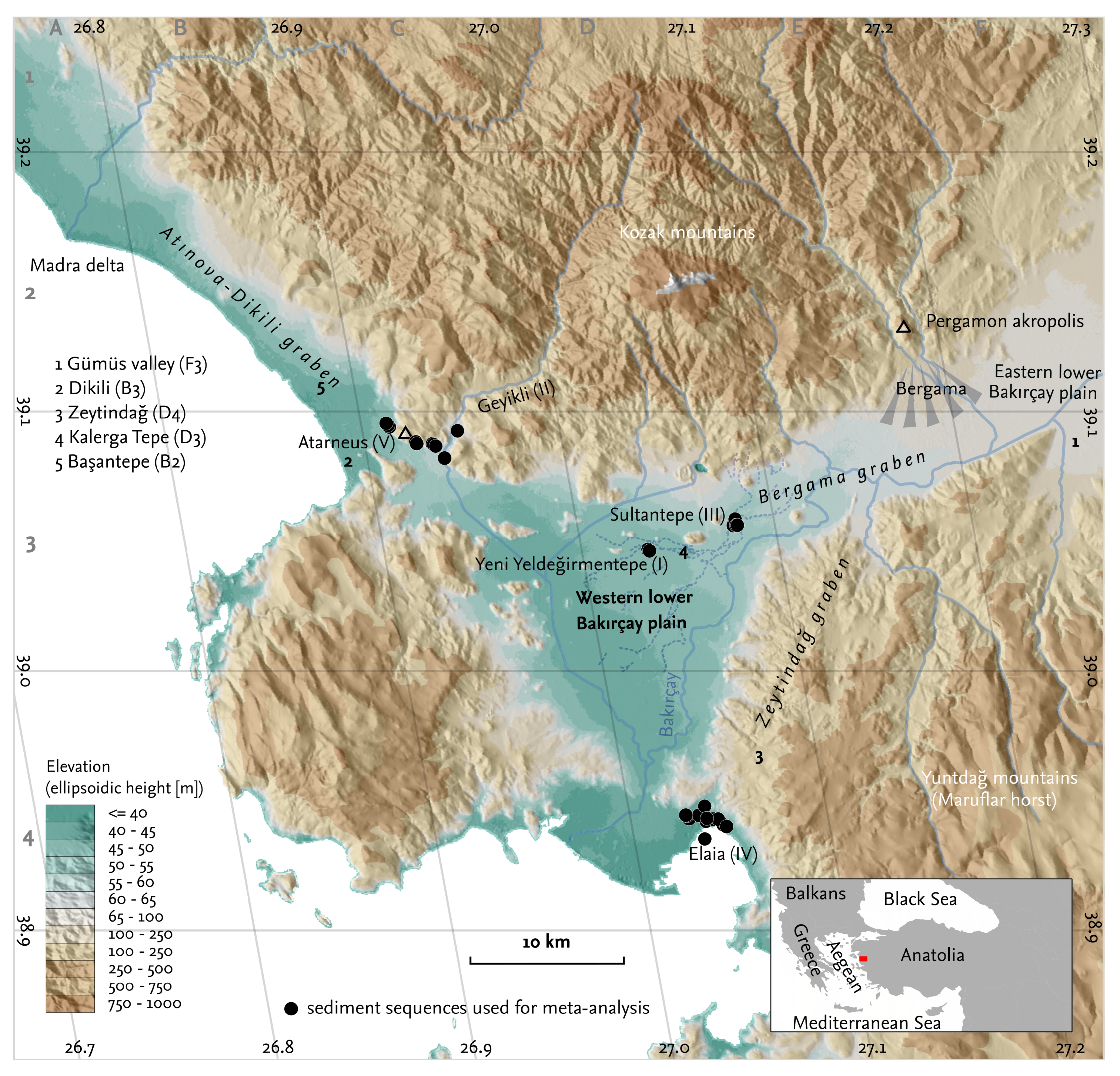


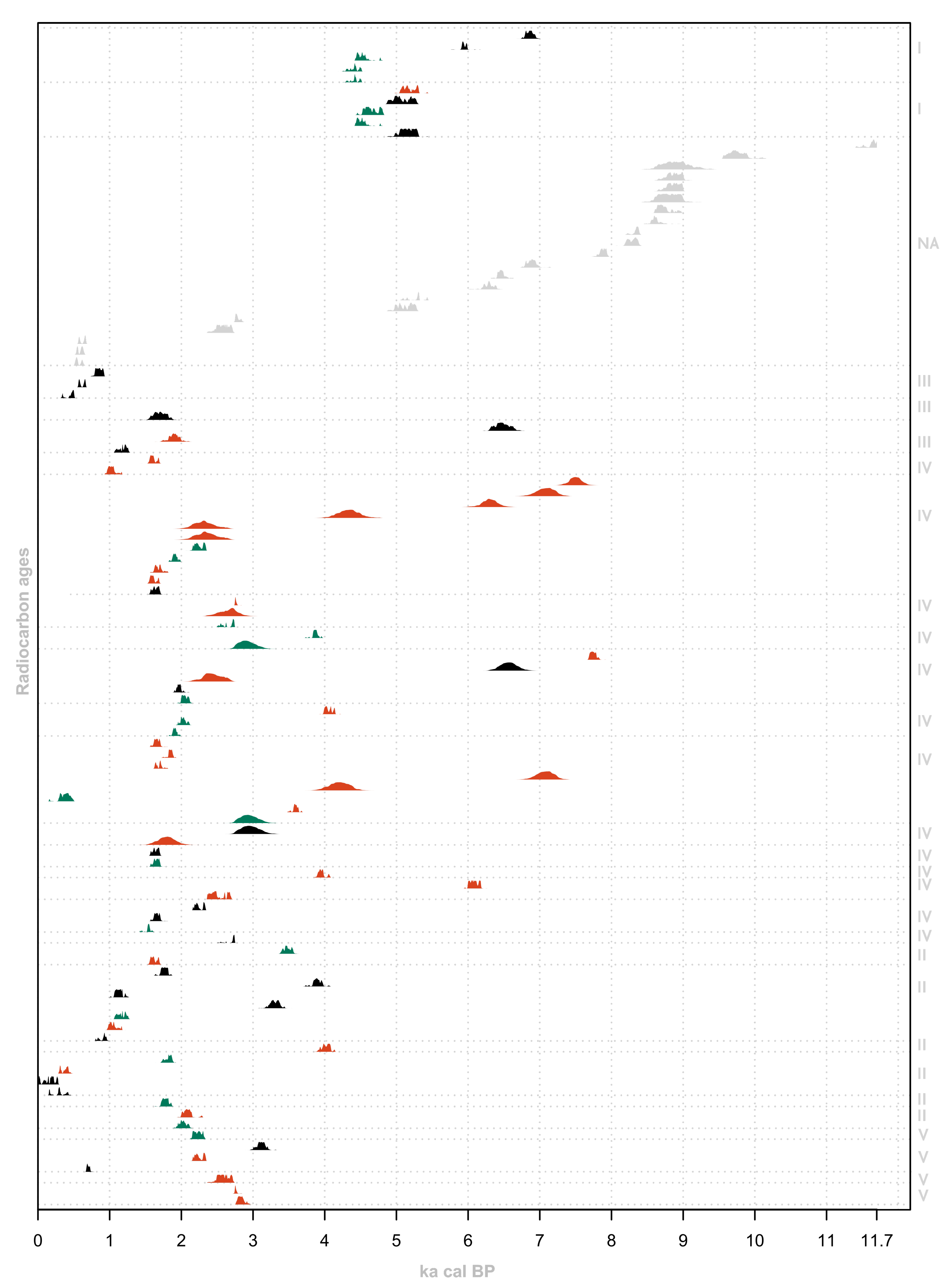
| Location | Sediment Sequences | Geomorphological Description |
|---|---|---|
| (I) Yeni Yeldeğirmentepe | 14C-ages mostly from fluvial sediment layers, some from cultural layers [50]; ; | Northern part of the western lower Bakırçay plain, transition zone of the footslope of a small andesitic hill (circa m) and the wide alluvial flat of the Bakircay plain; 1st order catchments (<0.001 km2) |
| (II) Geyikli valley | Fan/colluvial/sheetflow layers, overbank sediments, braided channel and bar sediments; 14C-ages mainly from fan and sheetflow deposits [48]; ; | Outcrops at the bank/terrace edge of the Geyikli creek, the catchments covers circa 95 km2, the lower Geyikli course is characterised by a narrow valley, fluvial terraces, and the streambed [48] |
| (III) Sultantepe | 14C-ages mainly from channel-related layers, one from overbank sediments [51]; ; | Slightly elevated position in the floodplain of the river Bakırçay, close to the border of the piedmont of the Kozak mountain; sediments affected by the Bakırçay (catchment > 2000 km2). |
| (IV) Elaia | Dating material from marine and terrestrial layers, the latter comprising fluvial and colluvial sediments [37,38,39,40,41]; ; | Closed and open harbor, open bay (sediments classified as marine) and low-order catchments of the littoral plain [37] (catchment area < 3 km2; area lies east of the Bakırçay delta) |
| (V) Atarneus | Dating material obtained mainly from fan and overbank sediments [49]; ; | Transition zone between footslope of a promontory of the Kozak mountains and the adjacent sedimentary plain (alluvial fans) [49]; 1st and 2nd order catchments (<0.5 km2) |
© 2020 by the authors. Licensee MDPI, Basel, Switzerland. This article is an open access article distributed under the terms and conditions of the Creative Commons Attribution (CC BY) license (http://creativecommons.org/licenses/by/4.0/).
Share and Cite
Becker, F.; Knitter, D.; Nykamp, M.; Schütt, B. Meta-Analysis of Geomorphodynamics in the Western Lower Bakırçay Plain (Aegean Region, Turkey). Land 2020, 9, 338. https://doi.org/10.3390/land9090338
Becker F, Knitter D, Nykamp M, Schütt B. Meta-Analysis of Geomorphodynamics in the Western Lower Bakırçay Plain (Aegean Region, Turkey). Land. 2020; 9(9):338. https://doi.org/10.3390/land9090338
Chicago/Turabian StyleBecker, Fabian, Daniel Knitter, Moritz Nykamp, and Brigitta Schütt. 2020. "Meta-Analysis of Geomorphodynamics in the Western Lower Bakırçay Plain (Aegean Region, Turkey)" Land 9, no. 9: 338. https://doi.org/10.3390/land9090338
APA StyleBecker, F., Knitter, D., Nykamp, M., & Schütt, B. (2020). Meta-Analysis of Geomorphodynamics in the Western Lower Bakırçay Plain (Aegean Region, Turkey). Land, 9(9), 338. https://doi.org/10.3390/land9090338