1. Introduction
Protected areas are defined by the International Union for the Conservation of Nature (IUCN) [
1,
2]. As such, they are demarcated geographical spaces which are recognized, dedicated and managed through legal proclamation or other effective means so as to attain the long-term conservation of nature and its associated ecosystem services, human cultural values and wellbeing [
1,
2,
3,
4,
5]. National parks are protected areas which are crucial for sustainable development in all environmental, economic, social and institutional facets. Thus, they are seen as a vehicle for biodiversity conservation at local, regional and global levels [
5]. Furthermore, protected areas such as national parks are regarded as tools for the prevention of habitat loss and degradation. They provide a way to prevent species disappearance induced by rapid landscape changes caused by the unprecedented impact of human activities such as agriculture and urbanization [
6].
The governance of national parks includes community–based, local, national, regional and global frameworks formulated at the various levels. They include but are not limited to Sustainable Development Goals (SDGs) such as SDG 15: life on land, SDG 13: climate action [
7] and the Nagoya Protocol [
8,
9]. The governance of national parks, which draws on a hierarchy of authorities, is complex and challenging. This is even more difficult if communities which live in the vicinity of the parks are marginalized. Thus, in order to promote sustainable natural resource management, communities have to be involved in decision-making [
10,
11,
12]. However, the continuous challenge is for the communities and national park managers to establish operational processes and actions which enable sustainable natural resource management.
The creation of national parks [
13] brings about social, political, institutional, economic and environmental changes to surrounding communities [
10]. For example, communities were displaced for the establishment of national parks such as Yellowstone National Park in USA [
14]. In Africa, the creation of protected areas was mostly as a result of colonial, often draconian, policies, where locals were obliged to leave their habitable land to make way for national parks [
15]. Other examples include Central Africa, where communities were displaced from rainforests to make way for national parks in the Congo basin [
16] and in Uganda where communities were displaced to establish Mount Elgon National Park [
17]. In South Africa communities were also displaced to make way for the establishment of the Kruger National Park [
18]. The removal of communities for the establishment of national parks was backed by draconian legislation to confiscate land. Local communities were marginalized in the developments leading to and after the establishment of the conservation parks with little or no regard for the communities’ livelihoods, role in biodiversity management or sustainability. As a result, the relationship between the parks and communities is characterized by ongoing conflicts and unresolved struggles over land and natural resources [
17,
19]. Currently, 14% of the terrestrial area in Africa is under protected area status, whereas in Zimbabwe 27% is under protected area status [
13].
Community resistance to the establishment of the national parks takes many forms. For example, the Masai Mara Nature reserve in Kenya is experiencing anthropogenic disturbances as a result of livestock grazing by the Masai community [
20]. Similarly, the Masai in Tanzania encroach into the park to secure their subsistence which has been negatively affected by the establishment of the Morogoro National Park [
21]. Some communities, like the Ogiek peoples of Kenya [
22,
23,
24], resorted to the regional courts to reclaim the land they were evicted from [
25].
The establishment of the Gonarezhou National Park in Zimbabwe resulted in the dispossession of the various communities living on the land. The communities who lost their ancestral land, cultural sites and livelihood resources were not compensated for these losses [
26,
27]. The pressure on livelihoods and limited access to natural resources caused increased human-wildlife conflict around Gonarezhou National Park in Zimbabwe [
28]. In order to address the tensions between communities and protected areas, the authorities responsible for the establishment and management of conservation enclaves are increasingly endeavoring to engage with neighboring communities. For example, the Communal Areas Management Programme for Indigenous Resources (CAMPFIRE) in Zimbabwe was formulated to mediate human-wildlife conflict [
29]. The program promotes community-based natural resource management and has facilitated a mutually beneficial engagement between rural local authorities, parks management, safari operators and communities. It is a progressive innovation that was duplicated in various forms in other countries [
29,
30,
31]. However, the CAMPFIRE program’s sustainability was undermined by governance challenges that included a lack of trust and transparency. Another example would be the Sangha Transnational Park which seeks to conserve the dense, remote and threatened forests lying between the borders of the Congo Republic, Cameroon and the Central African Republic [
32]. Trust, accountability and transparency tenets of good governance are often cited as crucial in natural resource management [
33]. When stakeholders involved in the management of a protected area trust each other, there are positive outcomes for conservation [
34,
35,
36]. The inclusion of communities in the management of protected areas has the potential to increase the sustainability of protected areas and ensure that there are mutual benefits from, for example, wildlife tourism [
37]. These community partnerships are known to yield better conservation and community benefits. Thus, accountable, inclusive, transparent, and legitimate collaboration can increase the sustainability of such partnerships [
19]. These experiences from CAMPFIRE and Sangha have provided valuable lessons to inform the formulation of stakeholder engagement in the management of protected areas [
38]. One of the initiatives that draw on these lessons is the partnership between the Zimbabwe Parks and Wildlife Management Authority (ZPWMA) and Frankfurt Zoological Society (FZS) which was established to manage the Gonarezhou National Park. This partnership is working with surrounding communities to establish inclusive meaningful management of the national parks. This study focuses on that partnership. This study has been initiated to complement existing knowledge on the management of protected areas. There have been many studies on livelihoods and poaching in Gonarezhou [
39], ecosystem services [
40,
41], climate change [
42,
43], human-wildlife conflict [
28] and tourism [
44]. There is, however, a dearth of studies focusing on stakeholder relationships and collaborative management in Gonarezhou [
27]. This study therefore (1) assesses recent innovations in the management of the Gonarezhou National Park, (2) evaluates the relationship between the park and communities, (3) examines and highlights challenges faced in the park and limits of the innovation, and (4) draws lessons from the case study of Gonarezhou to contribute to the scholarship in stakeholder engagement and protected areas.
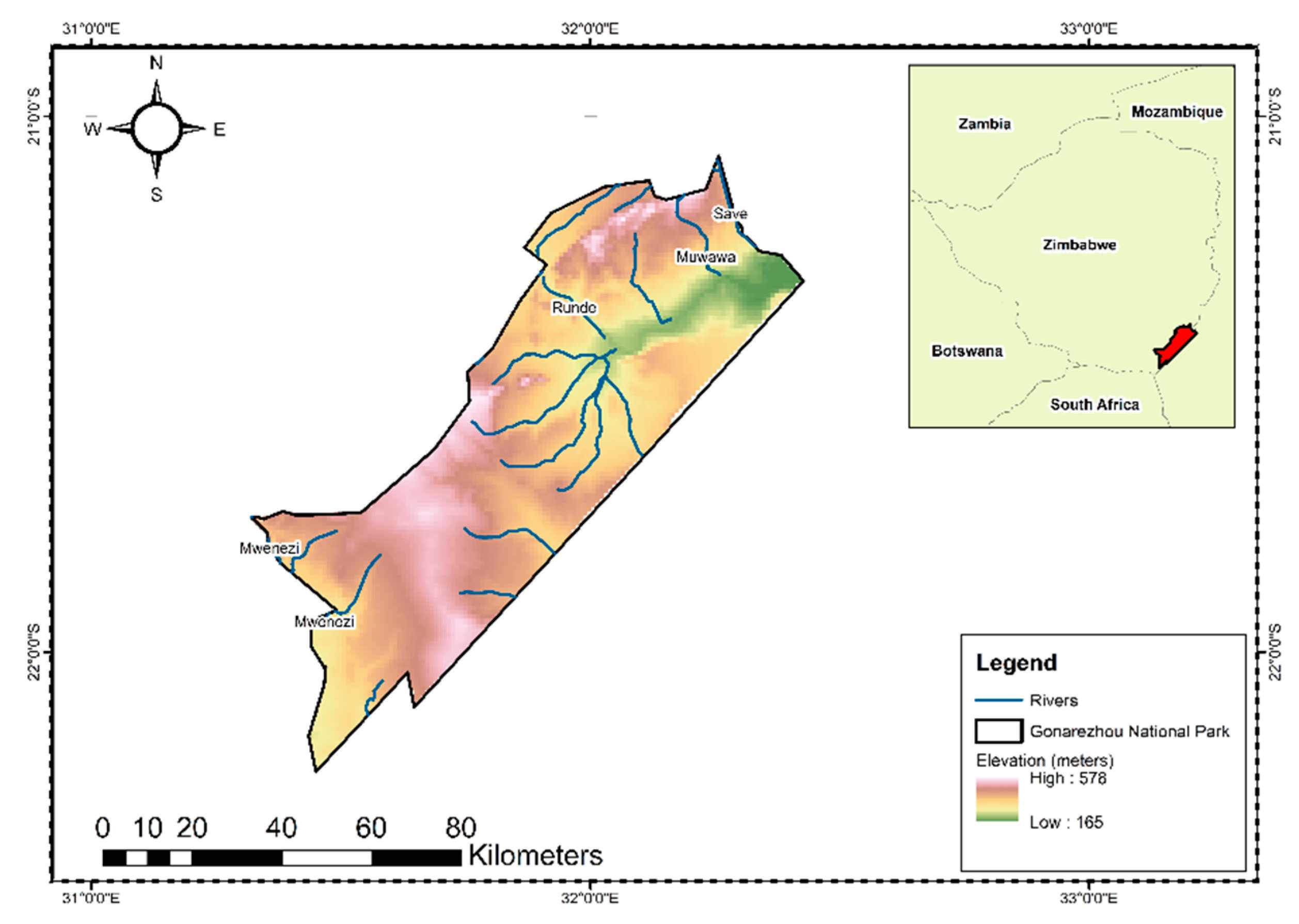
2. Study Area
The Gonarezhou National Park situated in South Eastern Zimbabwe covers an area of 5053 km
2 [
45] and is the second largest protected area in Zimbabwe. Gonarezhou was established as a game reserve in 1935 and declared a national park in 1975. The park consists of an undulating low-lying area, with the lowest elevation point starting at 165 m above sea level, peaking at 578 m (
Figure 1) [
45]. The area is considered a dryland with an average maximum annual temperature of 31 °C. It has winter day maximum temperatures averaging 27 °C and summer day temperatures averaging over 31 °C. The mean annual rainfall of 466 mm is classified as natural region 5 of Zimbabwe which is considered a dryland region [
45,
46]. The Runde, Muwawa and Save Rivers are in the northern section of the park, whereas the Mwenezi is found in the Southern section (
Figure 1). The name Gonarezhou literary means “the place of elephants” due to the large numbers of elephants found in the park. The current elephant population in Africa is estimated at 415,428, with Southern Africa accounting for 293,447 of the herd. It is important to note that Southern Africa’s elephant population is rebounding due to protection programs [
47], and Gonarezhou has a reputation as a premier destination for quality wildlife viewing. The park is an integral part of the Greater Limpopo Trans frontier Park (GLTP), a transboundary conservation area spanning South Africa, Mozambique and Zimbabwe. The GLTP combines the Kruger National Park in South Africa, Limpopo National Park in Mozambique and Gonarezhou National Park in Zimbabwe. The GLTP also consists of private land and concessions as well as communal areas in all three countries.
The park shares boundaries with the settlements under communal tenure such as Malipati, Save and the Chikombedzi. The demarcation of the Gonarezhou National Park in 1975 encroached on land belonging to the indigenous Shangaan ethnic group and resulted in the displacement of communities in its vicinity. These communities include the dominant Shangaan ethnic group as well as some Ndebele and Shona speaking communities [
26,
48]. Among the Shangaan groups who were evicted was the Chitsa community. The Chitsa community have continued to resist eviction and are currently settled within the park boundaries [
26,
48].
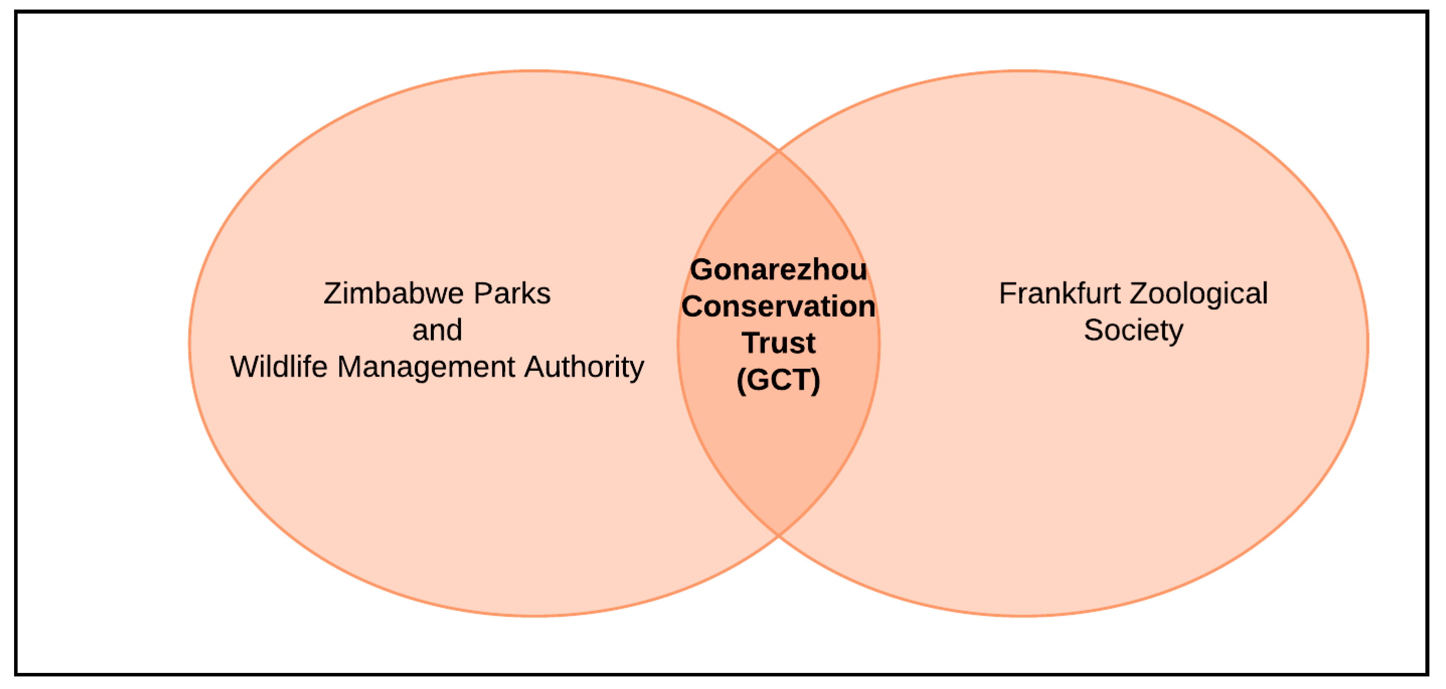
The Zimbabwe government exercises a mandate over the governance of the park through the Parks and Wildlife Act of 1975. The Governor in Masvingo Province where Gonarezhou is located is the government representative and oversees provincial affairs and is appointed by the President of Zimbabwe. The Zimbabwe Parks and Wildlife Management Authority (ZPWA) is a government agency administering national parks in Zimbabwe. Accordingly, the ZPWA has a mandate to manage the entire wildlife population of Zimbabwe, whether on private or communal lands. The Gonarezhou Conservation Trust (GCT), a partnership between the Zimbabwe Parks and Wildlife Management Authority and the Frankfurt Zoological Society was formed in 2017 and now manages the Gonarezhou National Park. The GCT Board of Trustees promotes conservation, commercial viability, community engagement, connectivity and cooperate governance of the Gonarezhou National Park (45).
3. Methods
The study relied on qualitative and quantitative data as the two are complimentary. The data was generated from primary and secondary sources. The secondary data consisted of published and unpublished materials available on the subject. The unpublished materials included records of the National Parks. Secondary data was mostly from documents published by the GCT [
45,
49] and other studies done on Gonarezhou. These were used to examine the history and evaluate the management of the park [
26,
27,
48,
50,
51,
52]. The primary data included satellite imagery and ethnographic methods. The main methods used were key informants and a structured questionnaire. The ethnographic interviews targeted key informants who were knowledgeable about the area and or held positions of influence in the park management and the surrounding communities, community leaders and local non-government organizations. A total of 20 key informants were purposively selected to reflect the diversity of views and experiences among stakeholders of the Gonarezhou National Park. The key informants were also purposively sampled to reflect a gender balance. The key informant interviews were triangulated with the secondary documents as well as follow up questions that were posed in the questionnaire. The researchers also triangulated key informant interviews through informal discussions they held with the stakeholders during the time of the study. The research team also observed participants going about their daily interactions within the park, and debriefed and reflected on their observations. This contributed to the triangulation of the primary data.
The key informant interview schedule was structured around the following themes: history, governance and operations of the GCT, community and stakeholder engagement, ecosystems and biodiversity management, sustainability and climate change. Under the history theme we asked respondents how and when the park was established as well as how it has evolved. On the governance aspect we inquired about the current governance structures of the GCT and its day-to-day operations. Likewise, on community and stakeholder engagement we focused on the GCT initiatives and its relationship with surrounding communities and stakeholders. When administering the key informant interviews, we adopted suitable protocols where we created standard definitions and explanations which were used in data collection [
53,
54]. NVIVO software was used to glean and create themes from the various categories as well as meanings which were derived from the gathered data. Secondary data where we consulted other journal articles and reports supplemented the gathered primary data [
26,
27,
28,
39,
40,
42,
44,
45,
48,
49,
50,
51,
52,
55]. The key informant interviews and secondary data revealed the four themes of history and current management of the Gonarezhou National Park, community engagement, conservation and connectivity, and challenges.
There were challenges with the data collection because of the national boundary of the park which made it impossible for us to engage with the broader constituency of the Gonarezhou as the trans frontier park. The national park in Zimbabwe is subject to various ministries which we did not engage, as these could possibly have complimented the information generated. The issue of land is emotional and political in Zimbabwe, and as a result the researchers had to engage sensitively with the displaced communities. A consequence of this sensitivity was that we failed to engage with the communities settled in the park. The researchers hired community members as research assistants, strictly observing the existing protocols to secure access to the affected people. We also had a limitation of time as we only visited during a particular season. This limited our insight into the ways in which seasonality influences the stakeholder relationships and biodiversity and ecosystem management. However, the authors are confident that the information generated forms an adequate basis for generating the depth of data needed to obtain the insights required to meet the objectives of the study.
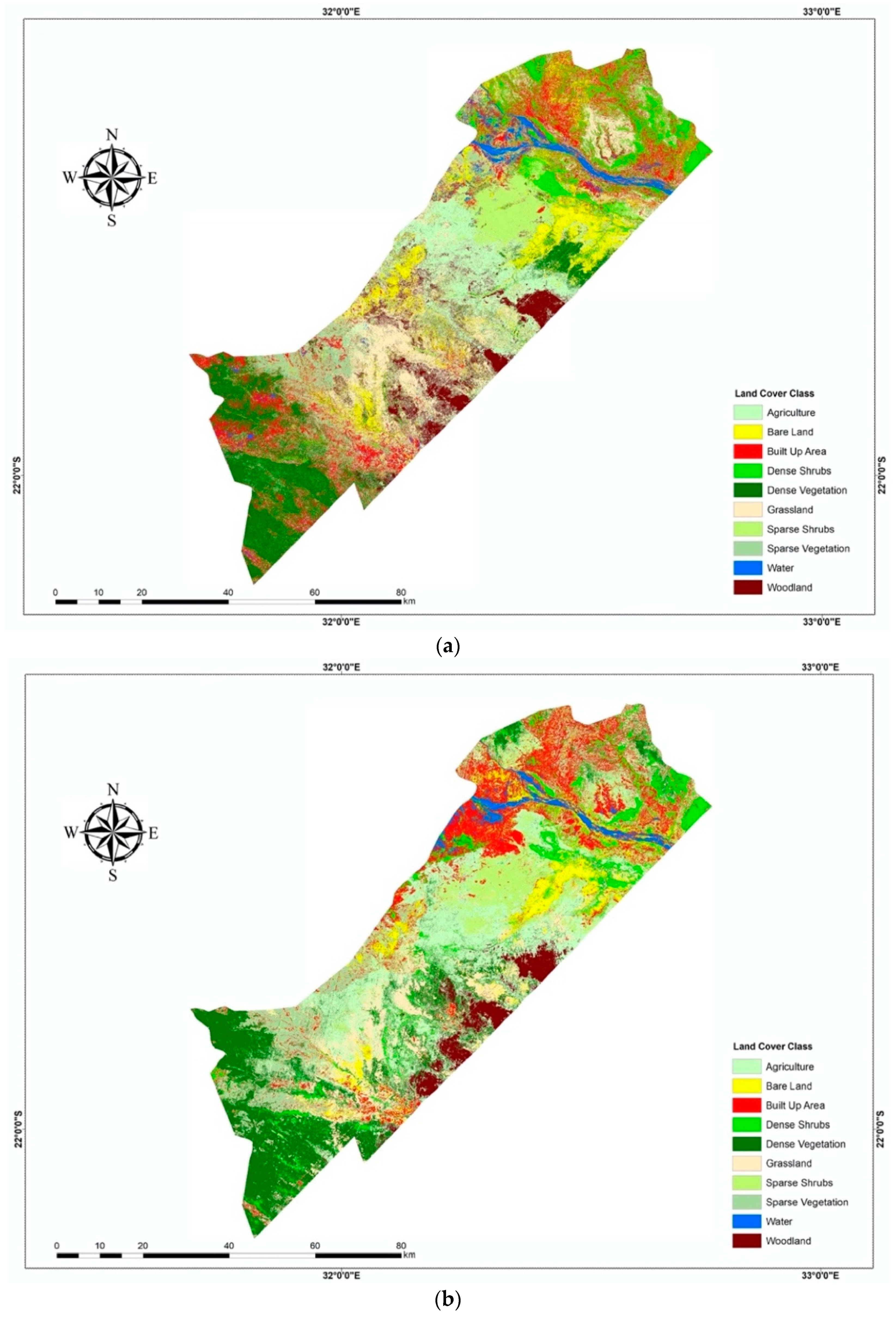
Landcover Classification and Analysis
For the conservation theme we also analyzed changes in land cover data, where we used Landsat 7 satellite imagery for 2007 and 2017 obtained from the United States Geological Services (USGS)]. Atmospheric and radiometric corrections using ArcGIS 10.5 were conducted on the Landsat images. Random forest supervised, pixel-based classification in ArcGIS 10.5 was used to classify the Landsat images. This classification was robust, effective and produced better results in environments such as Gonarezhou, and its utility has been demonstrated in many studies [
56,
57,
58,
59]. A Juno Trimble hand global positioning device was used to collect training samples for the classification and for conducting accuracy assessment. A total of 10 land cover types, consisting of agriculture, bare land, built up areas, dense shrubs, dense vegetation, grassland, sparse shrubs, sparse vegetation, woodland and water, were classified from the Landsat satellite imagery. Google Earth Pro and extensive field visits were utilized to verify the accuracy of the land cover classification [
60]. Consequently, an overall accuracy of 77% and a margin of error 23% for the land cover classification was realized, meaning that 77% of the time the landcover classification confirmed what was on the ground [
41]. The satellite imagery generated qualitative and quantitative data which were used to generate quantitative information and generate landcover change maps.
The rate of transformation of each landcover type was subsequently calculated from the land cover mapping, and crosstabulation of the land cover transformation was conducted using ArcGIS software. The transformation of each land cover type was calculated in percentages as shown in Equation (1) below [
61,
62,
63,
64].
where CA
i denotes the changes in the percentage share of areas covered by each land cover type in relation to the total area of study area (%); A
t+1 is the area of each type of land cover during the time interval t + 1 (ha); A
t represents the area covered with each type of land cover during the time interval t (ha); and TA represents the total study area (ha) [
61,
62,
63,
64]. The rate of transformation was utilized as a proxy to assess whether current efforts are bearing fruit in biodiversity conservation [
41].
4. Results and Discussion
4.1. Establishment of the Gonarezhou Conservation Trust
Here we present the reasons behind establishment of GCT and reflect why it is innovative. Gonarezhou was proclaimed as a national park in 1975 and a government entity managed the park. However, Zimbabwe faced budgetary and governance challenges which negatively impacted on the Gonarezhou National Park. These included a lack of manpower, a declining infrastructure, a decline in tourist visitors, destruction of vegetation and a loss of wildlife. Accordingly, in 2007 the ZPWMA signed a memorandum of understanding with the Frankfurt Zoological Society for 10 years. Under this memorandum of understanding (MOU) the FZS became the technical and financial assistance partner. However, this was a challenge, because Zimbabwe continued to experience turbulence in the governance of land and natural resources, and tourist numbers continued to decline. In 2013, a new MOU between the FZS and ZPWMA was signed which would assist in acquiring manpower, promote revenue generation through tourism, ensure conservation and promote community engagement and participation. Overall, the GCT is trying to maintain and increase the biodiversity of animals in Gonarezhou National Park. In 2017, the ZPWMA and FZS partnered to form the Gonarezhou Conservation Trust (
Figure 2).
This partnership is viewed as an innovative model for managing protected areas and is built on a relationship developed over nine years, during which time, the FZS provided technical assistance to Gonarezhou. The GCT is currently responsible for running the park under a board of trustees made up of equal members from the ZPWMA and the FZS for a period of 20 years. However, there are no community members on the board. The GCT has five main objectives referred to as the five “Cs”, namely, conservation, commercial, community, connectivity and cooperate governance. These are discussed below.
4.2. Community Engagement
In this section we highlight and assess the relationship between the park and communities. Before the establishment of the GCT, there was barely any community engagement, and the relationship with the national park was adversarial. The park criminalized the communities and focused on policing them. This made it difficult for communities to negotiate access to the park for resources for subsistence, construction of their shelters or to perform their cultural ceremonies. When the community did have access, it was considered trespassing and they were liable for arrest. The national park wildlife encroached on the communities’ agricultural lands and posed a constant threat to their livelihoods, and communities had no recourse. The formation of the GCT recognized the community as a strategic pillar of the Gonarezhou National Park [
45]. This culminated in the engagement of the community through a project called the
“Mpfhuka” project which means a journey of community engagement with local communities to ensure a better relationship with the community. The
Mpfhuka project provided an engagement platform which was used to inform communication, engagement, empowerment and education of the communities.
The GCT uses the “Mpfhuka” platform to mobilize all communities within and outside the park boundaries. The mobilization is aimed towards developing a common vision about the protected area. Nevertheless, the meetings between communities and the GCT are described as ’tense’, as communities are given an opportunity to criticize the GCT. For example, one community member says “the GCT expect us to listen to them but they should also listen to us”. Challenges also arise in developing a common vision because of the trust deficit that the communities have of park management. Communities believe that GCT prioritizes animal welfare at the expense of human well-being in the conservation efforts. For example, one key community member said, “wildlife is the number one priority of GCT”. Communities are also not happy about the GCT failure to adequately compensate them for the losses they incur as a result of the human-wildlife conflict. Some of the tensions could be attributed to community unhappiness at the terms of engagement as well as the legacy of painful memories of dispossession. The outcome of the dialogues lays out the work that the GCT needs to do to engender community trust in the new stakeholder engagement strategy.
The GCT uses the “Mpfhuka” project to assist communities in managing and promoting their eco-tourism sites such as bird watching at the Manjinji pan in the Sengwe community. Under the “Mpfhuka” project the key informants explained that the GCT established a liaison officer who is a mediator between park management and the community. This move to appoint a mediator established communication channels between the GCT and the community. The “Mpfhuka” project provided a platform for dialogue between the communities that were displaced to make way for the park. As a result, the two parties agreed on the terms by which the displaced communities could access the Gonarezhou National Park to visit their traditional and cultural sites within the park so as to practice traditional rites such as rain making ceremonies. The “Mpfhuka” project also enables community empowerment as well as awareness and allows communities to harvest natural resources in the park.
The
“Mpfhuka” education project, through the GCT, enables schoolchildren and local communities to undertake educational tours in the park. These education and awareness-raising campaigns targeting school children are a
“simple and fun way” for intergenerational transfer of knowledge on climate change, conservation, and tree planting. The GCT assists in a book project and facilitates the provision of limited scholarships for studies linked to the environment in higher education. The liaison team at GCT believes that such education campaigns promote environmental stewardship which leads people to appreciate the environment and results in reduced poaching, as observed in other studies [
65,
66]. One key informant noted that the educational and awareness campaigns
“create a sense of ownership and appreciation of nature which develops future environmental stewards”.
The GCT is focusing on community empowerment to ensure that communities benefit from tourism and conservation. Firstly, the GCT engages the community, and disadvantaged women in particular, to ensure economic empowerment and that the community benefits from the tourism revenues. The GCT buys the women’s handicraft which is used to furnish some of the buildings of the GCT. Some of the women in the community are involved in selling the grass for thatching. The GCT employs “more than 80% of employees from local communities” which promotes inclusivity, involvement and a sense of ownership since communities would say “it is our local children who work in the park”. The GCT also hires community members for the construction and maintenance of community themed camps called ‘Mananga camps’, which are used for tourist accommodation. Local community members are also employed as tourist guides. The employment generates cash for the local community and reduces community reliance on unsustainable exploitation of the protected area resources.
The GCT have enabled the community to harvest building materials like thatch which are used for construction of community housing structures. Community members also have permission to gather fruit and medicinal plants from the protected area under the supervision of GCT officials. During droughts, the GCT also allows communities to cut grass in the park to give to their livestock. Likewise, communities can harvest natural vegetables in the park and harvest fish bi-annually or upon request in consultation with traditional leaders so as to allow regeneration of this resource. The most common natural vegetable harvested is spider leaf/nyeve/ilude (Cleome gynandra) which is a local delicacy, and some of the communities sell it to earn a living. The GCT and communities have devised ways to ensure that the terms on which communities enter and exploit the park are sustainable.
The key informants believe that the ‘
Mpfhuka’ project has improved relations between the GCT and communities. The GCT’s community engagement strategy has potential to be sustainable. Other studies note that engaging communities is also seen as a form of environmental justice. Examples of this are the engagement of communities adjacent to Kruger National Park in South Africa [
67] and attempts to engage the Baka and Aka hunter-gatherers in the Sangha Tri-National in Cameroon [
68]. The sustainability and effectiveness of this can only be ascertained over time [
69]. Further studies around community engagement and conservation are required to explore this notion in Gonarezhou, because most of these have focused on conservation while neglecting the social and political processes involved in community engagement [
70]. However, more needs to be done to ensure sustained community engagement in natural resource management.
The community argues that they should also benefit from tourist activities at Gonarezhou. This highlights the importance of the tourist contribution to the financial sustainability of the ‘
Mpfhuka’ initiative. The secondary data showed that there was an increase in tourist arrivals from 2100 to 5000 between 2009 and 2014 which consisted mainly of locals compared to regional and international tourists [
51]. The increase in tourism was largely because of the positive perceptions which local tourists have of Gonarezhou [
51]. The Gonarezhou National Park is enhancing revenue generation efforts through the inclusion of mini events and conferences in the park, which pulls tourists to the neighboring Kruger National Park in South Africa. We observed that mini-conference facilities where established at Simuwini camp. Accordingly, the GCT opened a training center and engaged in aggressive marketing in 2019. It also engaged a business development manager to oversee the commercial aspects of the park, and these efforts are expected to increase the number of tourists. It is therefore recommended that the GCT should engage in efforts to ensure financial sustainability and attracting more tourists from regional and international markets. Thus, financial sustainability is crucial in the management of national parks. Financial sustainability of the park is also crucial in facilitating community engagement. National parks need to upgrade their infrastructure and devise innovative products, such as virtual wildlife safaris, which boost revenues. Consequently, more research on the emerging trend of virtual wildlife safaris is proposed.
4.3. Conservation and Connectivity
The GCT views the community as an integral part of enhancing conservation, however the GCT acknowledges that this is a challenging but essential task for sustainable conservation. Gonarezhou is dominated by Mopane, Guibourtia and Combretum woodlands, and the aim is to positively maintain or increase the vegetation [
45]. Likewise, the GCT also seeks to conserve wildlife and flora, and reduce threats which lead to a decline in wildlife [
45]. Consequently, in this section we present the results of the landcover change from Landsat satellite imagery over a 10-year period (2007 to 2017) which covers the conservation theme. The satellite data shows that there has been negative transformation of sparse vegetation, sparse shrubs, grasslands and dense vegetation which had a CA of −9, −6, −6 and −1, respectively (See
Figure 3 and
Table 1). The negative transformation implies that the various vegetation classes declined between 2007 and 2017.
The negative transformation, as confirmed by the key informants, is due to the increasing number of large herbivores particularly elephants which number approximately 11,000. This is “
beyond the ecological carrying capacity” of the park as highlighted by the key informants. and has led to habitat loss and degradation. This is an important finding as it indicates that the communities are not responsible for the loss of biodiversity. This situation undermines the community-park engagement as it fuels the community perception that the GCT prioritizes wildlife over human welfare in conservation. The GCT is challenged to address the threat posed by the wildlife to the habitat. The GCT faces several challenges, as the damage caused be elephants extends beyond the park into the communities’ settlements. The traditional mechanisms for addressing wildlife population excess are no longer available. Elephant culling is prohibited by the Convention on International Trade in Endangered Species of Wild Fauna and Flora (CITES). Exporting live elephants as a strategy is also limited by the CITES guidelines [
71]. Previous attempts to export elephants from Zimbabwe to other countries led to a public outcry. The GCT is therefore placed in an untenable position about the choices it must make to ensure the sustainability of the protected area and reduce human-wildlife conflict.
On the other hand, the protected area has come under pressure from the human agricultural activities in the park. This is attributed to the settlement of the Chitsa community in the northern section within the park boundary, who were given permits by the then governor of Masvingo province to settle, cultivate crops and graze their animals in the park in 2000 during the Fast Track Land Reform Program [
26]. This permission to resettle was given without the knowledge of the Minister of the Environment who oversees national parks in Zimbabwe. The Chitsa Chief also views the settling of people in the Gonarezhou National Park as a restitution of their ancestral lands [
26,
27]. The combination of an excess elephant population and settlement of human beings in the park is undermining conservation efforts and precipitating loss of land cover. This has destabilized the fragile ecosystem [
72]. These developments illustrate the park’s vulnerability to government failures to resolve land injustice issues. This is in line with a trend in Africa and in Zimbabwe in particular, where redistributive land reform efforts and programs have attempted to correct past injustices. At the time of writing, the challenges posed by the elephants and the settlement of people in the park had not been resolved. Such a situation is likely to frustrate GCT conservation efforts and requires extended stakeholder engagement. The situation must be discussed at ministerial, provincial and community levels, and a solution realized which is amicable for all. Nevertheless, this is a challenge given the contested nature of Zimbabwean politics and polarization which often make it challenging to implement collaborative management for natural resource management [
73].
There has been a positive increase of dense shrubs with a CA of 5 which could possibly entail bush encroachment which is a sign of land degradation [
74]. Woodland has remained constant which may mean that conservation efforts are registering a positive impact. This shows that area-based management through the creation of national parks plays an important role in reducing habitat loss and maintaining species diversity. The landcover analysis from satellite data also demonstrates the importance of using remote sensing in monitoring impacts of landcover on ecosystems services. National parks in Zimbabwe lack resources and capacity to engage in research on landcover which hampers their ability to respond to climate change. However, partnering with the scientific communities such as universities and research institutes can provide resources to generate the empirical data needed to inform policymaking. Currently the ZPWMA is keen to partner with local universities to engage in collaborative research, but owing to resource constraints, collaborative research has been limited.
From a faunal perspective the key informants pointed out that there has been an increase in large herbivores. This was confirmed by the aerial survey in 2016 of large herbivores which estimated the population of elephant to be 10,715, impala 7421, buffalo 4797, kudu 1789, and zebra 1830 [
49]. The aerial survey indicated that there has been a general increase in large herbivores since 1992 which points to better management and conservation leading to an increase in wildlife in Gonarezhou. Similarly, the key informants and the predator survey in 2017 also indicated an increase in the number of predators such as lions from 54 to 62 in 2016 and 107 wild dogs which have increased exponentially over that past years. Maintaining predators in an ecosystem is crucial for a balance and ensuring a stable supply of ecosystem goods and services [
4]. Overall, the GCT is trying to maintain and increase the biodiversity of animals in the Gonarezhou National Park. However, the 2016 aerial survey highlighted several challenges such as an increasing presence of domestic livestock. The key informants also confirmed that communities graze their livestock within the park, and wild animals, in particular elephants and buffaloes, raid cultivated fields of communities. Such dynamics perpetuate the human-wildlife conflict. Grazing domestic animals in national parks is not allowed by legislation. Nevertheless, some communities graze their animals in the park owing to a lack of pasture in communities, and porous boundaries. This human-wildlife conflict further demonstrates the need for collaborative management in national parks. Results revealed that communities burn chili-briquettes, producing smoke which irritates elephants thereby repelling them from raiding their crops. Thus, parks affect people and likewise communities affect parks, and the ‘‘
Mpfhuka’ project where the GCT continuously engages communities is a platform to air issues and resolve conflicts.
Enforcement is also challenging, given the elongated nature of the park and the fact that it covers a vast area of 5053 km
2. From an enforcement perspective, prior to formation of the GCT, enforcement and security were hampered by a low staff compliment. The key informants highlighted that the GCT has increased the number of field rangers who conduct foot patrols in the park to 130. The GCT conducts regular training and uses innovative technologies such as the Spatial Monitoring and Reporting Tool (SMART) as an enforcement mechanism [
45,
75]. The GCT also acknowledges that enforcement alone is not enough and that engaging communities ensures long-term sustainability and a reduction in poaching. If the SMART tool and other information communications technologies (ICT) are used by villages adjacent to Gonarezhou, there is the potential that information can be shared with the GCT. Hence this will add another layer of protection and law enforcement. For example, selected community members can be trained on the use of SMART as it only requires a cellphone, and these community members can report any suspicious activities to GCT, thereby strengthening the collaborative management of the park. However, the community members utilizing the SMART require incentives such as a stipend for effective monitoring. The issue of incentives is a reemerging theme, where there must be incentives such as stipends or any other incentives which improve their livelihoods. Thus, there is a need to further explore the use of ICT in conjunction with traditional foot patrols in combating wildlife crime.
Besides the elephants and human settlements, the national park faces threats from poachers, livelihoods stress induced by cyclical drought, economic decline of Zimbabwe and a decline in tourism arrivals. The latter was compounded by Covid-19 induced travel restrictions.
4.4. Challenges
The proceeding discussion examines the challenges faced in the park and limits of the innovation. We draw lessons from the case study of Gonarezhou to contribute to the scholarship in stakeholder engagement and protected areas. The GCT faces several challenges that include the governance of the park, stakeholder engagement, community distrust and lack of coordination among the government representatives in the country. The international protocols for managing elephant populations also undermine the viability and sustainability of the GCT initiative.
The livelihood stresses endured by the poor communities living around the park exert pressure on the communities who may have no option but to resort to unsustainable use of the park to secure their livelihoods. The unsustainable use includes poaching of wildlife for subsistence purposes, unsustainable harvesting of vegetation and biodiversity resources, and the communities’ participation in commercial sophisticated poaching networks targeting big game animals such as elephants. Through education and awareness campaigns and supporting livelihoods of local communities, GCT is trying to reverse these trends. The communities argue that more still needs to be done to enhance their livelihoods; nevertheless, under the difficult economic climate in Zimbabwe this is a challenging task for the GCT.
A further challenge is a lack of coordination between the national and transboundary governance authorities. The key informants mentioned that the Great Limpopo Trans frontier park was formed in 2002 between heads of state of South Africa, Mozambique and Zimbabwe and overlooked its localized impacts. As an example, the Gonarezhou National Park is supposed to link with the Kruger National Park in South Africa through the Sengwe corridor. However, this is inhabited by communities in villages. Therefore, movement of wildlife around and through the corridor would increase the incidences of human-wildlife conflict which is already rife in the area. This experience highlights the need for improved coordination and policy consistency between the diverse authorities engaged in the governance of conservation areas.
The other challenge is the failure by the GCT to deal with the issues of compensating communities for the losses to wildlife which encroaches on their fields and settlements and has created a long-standing grudge over the historical dispossession of land.
The management of protected areas is also facing challenges because of climate change and variability. One of the key informants highlighted this by saying
“just look everywhere you go and turn in this area it’s just dry”. For example, the droughts in 1992, 2002, 2008, 2012 and recently in 2018 have led to food insecurity within communities around the park leading to loss of livelihoods and livestock which increases the rate of small-scale poaching in the park [
76]. It was also noted by one of the key informants that there is farm abandonment because of climate change which is exacerbating poaching activities. Climate change induced drought leads to the migration and relocation of animals and their death. More resources are thus required to feed animals as fodder must be prepared or purchased; likewise, the supply of water in natural pans dries up, requiring the need to pump water artificially for animals. However, there are no artificial water pans in Gonarezhou as it is management’s approach not to interfere with nature but rather to let the system self-regulate.
Climate change affects ecosystem functions because vegetation is reduced or destroyed leading to elephants moving to locations with water. In this process they destroy important ecosystem services such as mopane and acacia woodlands which are important in carbon sequestration and provision of good quality habitats [
52,
55]. Similarly, extreme events such as cyclones have destroyed infrastructure, in particular the bridge which connects the northern and southern sections of the park. This has undermined tourists’ access to the southern section. These droughts and extreme events have affected land use planning and community relations with the park. For example, the key informants indicated that while the GCT encourages people to destock their livestock so as to minimize loss during droughts, some communities still choose to keep them which further fuels human-wildlife conflict. Furthermore, activities in communities outside pose challenges for land use management inside the park. For example, some communities outside the park practice streambank cultivation which leads to soil erosion, disturbing the aquatic systems in rivers through shifting of water pools and affecting the fish population negatively.
5. Conclusions
The purpose of our study was to (1) assesses recent innovations in the management of the Gonarezhou National Park, (2) evaluate the relationship between the park and communities, (3) examine and highlights challenges faced in the park and limits of the innovation and (4) draw lessons from the case study of Gonarezhou to contribute to the scholarship in stakeholder engagement and protected areas. From the study it is evident that for successful management of protected areas, communities must be involved as important stakeholders. However, the terms on which communities are engaged still remains a challenge. Thus, the GCT acknowledges the importance of community mobilization and development, and as a result they have started on a journey of
“Mpfhuka” which engages surrounding communities. Through
“Mpfhuka” the GCT engages the community in conservation while at the same time supporting it in its efforts to improve its livelihood. Other studies also concur that community engagement is an evolving and learning journey that is vital for the collaborative management of protected areas [
10,
17,
77]. Trust is crucial for effective collaboration with communities in the management of protected areas. However, it takes time to build sustainable relationships and solid trust [
10,
35]. A lack of support from or involvement of communities threatens protected areas [
17,
77], for example, through poaching activities in the national park. Solutions for challenges such as poaching as a result of poverty and poor or weak coordination amongst implementing agencies must continuously be sought. Thus, we propose more efforts to engage with and benefit communities from wildlife tourism of protected areas to deter negative and retrogressive actions by communities. Protected area managers are encouraged to therefore genuinely seek to engage communities and not view them as threats.
Our study highlights the importance of innovative partnerships between state and non-state non-profit organizations, local communities, and local and international partners in managing protected areas in Zimbabwe and elsewhere as they provide financial and technical assistance crucial in protected areas administration. Prior to the GCT partnership, tourist numbers were declining, and the conservation efforts were suffering. It is important to note that protected area management is not only about conservation but also about increasing revenue from tourism, enabling protected areas to become self-sustaining.
From a conservation perspective, the partnership has increased elephant and wildlife populations which shows the utility of area-based approaches in conserving wildlife. However, this has resulted in human-wildlife conflict and the park carrying more elephants than it can manage. Nevertheless, international statutes do not allow the culling of elephants, so park authorities are left to deal with a growing problem of animal numbers. Exporting the elephants would be a solution but it is done under strict guidelines. Thus, while it is noble to follow international statutes such as CITES, this should not be at the expense of sustainable management of natural resources and negative outcomes on local livelihoods. This shows the complex structures governing protected areas that need to be navigated as well as divergence between policy and practice.
From a land cover perspective there has been a positive increase of dense shrubs and maintenance of woodland which is crucial for the supply of ecosystem services. The paper illustrates that there are limits to how much local based initiatives like the GCT can resolve vulnerabilities of protected areas. The issues of CITES regulations, community sentiments, transboundary resource governance and sensitivity of natural resource governance issues pose serious challenges whose resolution is beyond the scope of the GCT and this publication. However, the transboundary protected area management regimes and global conservation frameworks have the potential to provide the framework within which these can be sustainably tackled. The findings are that the initiatives like this one work best in a contained environment with a broader stakeholder base engagement. The stakeholder base should be expanded to include the diverse government departments engaged in the governance of natural resources This is even more complex with managing transboundary conservation such as the GLTP. While it is worthwhile and noble to engage in transboundary initiatives, these are difficult to implement due to complex governance structures and competing interests. Lastly, innovative partnerships with communities are crucial for sustainable management of natural resources; however, governance, climate change, and trust are challenges which must be navigated in protected area management.

 ,
, 
