Article

Inventory and Distribution of Rock Glaciers in Northeastern Yakutia

Melnikov Permafrost Institute, Siberian Branch of the Russian Academy of Sciences, Yakutsk 677010, Russia
Land 2020, 9(10), 384; https://doi.org/10.3390/land9100384
Submission received: 2 September 2020 / Revised: 5 October 2020 / Accepted: 8 October 2020 / Published: 10 October 2020
(This article belongs to the Special Issue Permafrost Landscape)

Abstract

:
Rock glaciers are common forms of relief of the periglacial belt of many mountain structures in the world. They are potential sources of water in arid and semi-arid regions, and therefore their analysis is important in assessing water reserves. Mountain structures in the north-east of Yakutia have optimal conditions for the formation of rock glaciers, but they have not yet been studied in this regard. In this article, for the first time, we present a detailed list of rock glaciers in this region. Based on geoinformation mapping using remote sensing data and field studies within the Chersky, Verkhoyansk, Momsky and Suntar-Khayata ranges, 4503 rock glaciers with a total area of 224.6 km2 were discovered. They are located within absolute altitudes, from 503 to 2496 m. Their average minimum altitude was at 1456 m above sea level, and the maximum at 1527 m. Most of these formations are located on the sides of the trough valleys, and form extended sloping types of rock glaciers. An assessment of the exposure of the slopes where the rock glaciers are located showed that most of the rock glaciers are facing north and south.

1. Introduction

The geography of distribution of rock glaciers is quite extensive. They are found in many mountainous regions of Europe, North and South America and Asia, including some circumpolar regions [1,2,3,4,5,6,7,8,9,10,11,12,13,14,15,16,17,18]. Their role as one of the sources of fresh water in arid and semi-arid regions in the coming decades will increase due to global warming. Therefore, taking into account the content of internal ice and its effect on the flow of mountain rivers is an important task of modern geomorphology [19,20]. However, for this, we need to know about their distribution in mountainous regions, especially in the areas with little to no information on them [21].
On the territory of Russia, rock glaciers are found in all mountain ranges, starting from the Caucasus and ending with the Chukchi Highlands, at altitudes from 0 to 3400 m [22]. The features of their distribution in individual mountain regions are described in the works of A.P. Gorbunov [15,16,22]. In the Russian part of North Asia, the coastal 150–200 km zone of the Okhotsk and Bering Seas is the most analyzed, which include the Chukchi, Koryak and Kolyma Uplands and others. More than 6500 rock glaciers of various morphological types are found here [23]. They are confined to the hypsometric interval from 0 to 1400 m. However, most of them are concentrated within 600–800 m [24]. In the rest, only the Suntar-Khayata Mountain Range has been studied so far, where rock glaciers are found in the altitude range from 1297 to 2402 m. So far, 540 rock glaciers have been discovered here, most of which are located in the altitude range of 1500–1900 m [25]. In this work [25], the discovered rock glaciers were marked with chiseled conventional signs that do not take into account area statistics. For the remaining mountainous part of Russian North Asia, information on rock glaciers is not available, despite the fact that the conditions for their formation here are optimal thanks to the presence of permafrost and large mountain structures, such as the Verkhoyansk, Chersky, and Momsky Ranges [1].
This work aims to discuss new data on the distribution of rock glaciers in the mountainous regions of northeastern Yakutia, based on the interpretation of satellite images and a digital elevation model. The mapping results were tested by field observations in the central parts of the Chersky and Suntar-Khayata Ranges.

2. Materials and Methods
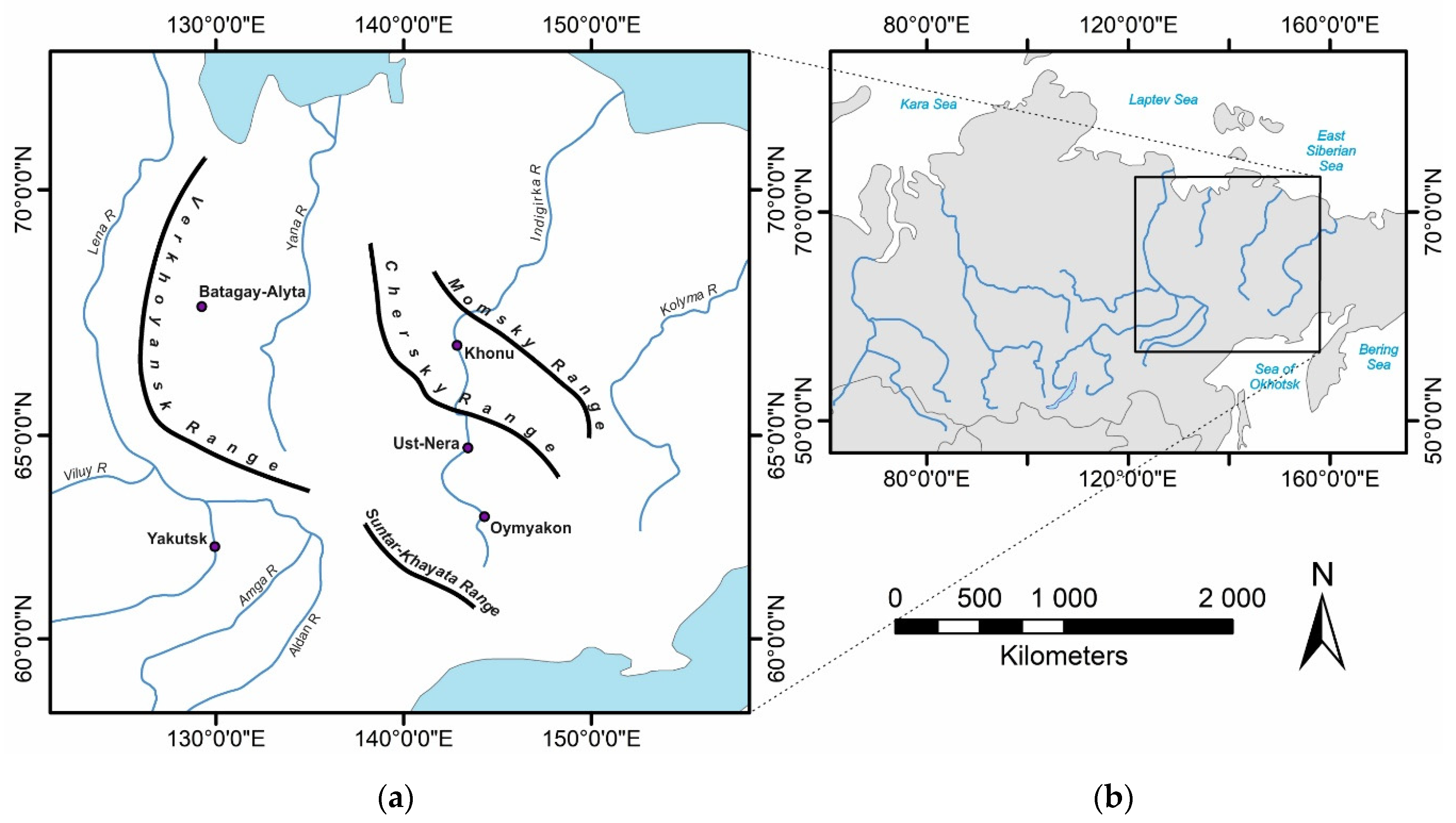
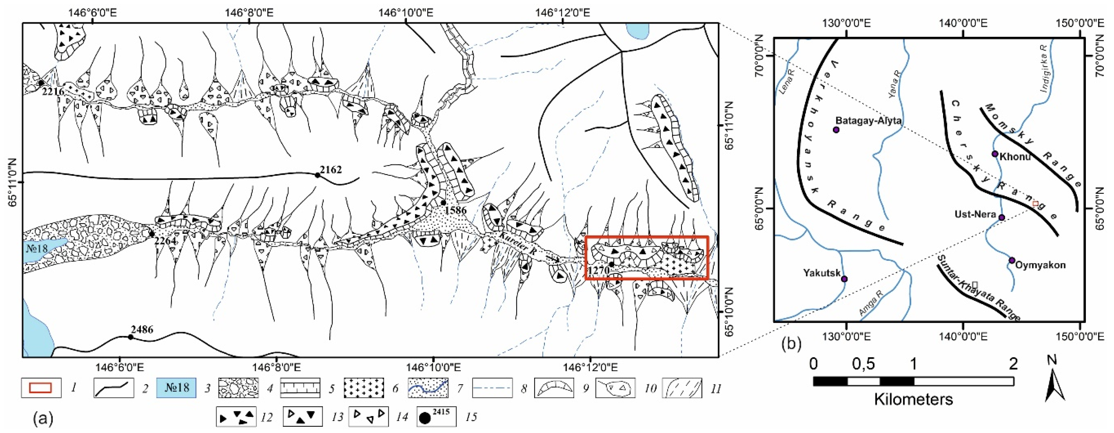
2.1. Research Area

The research area includes four large mountain ranges: Chersky, Suntar-Khayata, Verkhoyansk and Momsky (Figure 1).
The Chersky Range is the largest mountain system in North Asia. It stretches for 1500 km in the northwest direction and is comparable in size with the Caucasus or the Urals. Here, we find the highest elevation in northeast Asia—Peak Pobeda, Sakha (3003 m). The relief has an alpine characteristic—with sharp ranges and peaks, with many cirques. The latter are of modern glaciation of the corrie-valley type, the area of which was 113 km2 at the beginning of the 21st century [26]. The central part of the territory is characterized by sharp dissection, where fluctuations in absolute altitudes sometimes exceed 800–1000 m. The slopes are characterized by significant steepness, reaching 60–70° in the central part of the massif. The trough-type river valleys are incised to a depth of 1000 m and can have a width of 500–700 m. According to the nearest weather station (Ust-Nera Town), located at an altitude of 523 m, the climate is cold and sharply continental. The mean annual temperature of the region is −12.6 °C, the monthly July temperature is 16.5 °C, in January −44.1 °C, and the annual precipitation is 212 mm.
The Suntar-Khayata Range extends 450 km in the northwest direction. The highest altitude of the mountain system of Mus Khaya (2959 m), in the corries of which lie the most studied glaciers of Northeast Asia [27,28,29,30,31,32,33]. The total area of modern glaciation of the corrie-valley type is 129.97 km2 [34]. The peripheral part of the Range is characterized by absolute altitudes up to 2000 m. The most elevated central part of the Range is characterized by a sharply dissected (800–1000 m) alpine relief, with many corries with modern glaciers, trough valleys and cirques. According to the nearest weather station (Oymyakon Village), located at around 736 m, the climate of the studied region is cold and sharply continental. The average annual temperature of the region is −14.2 °C, the monthly July temperature is 15.6 °C, January −44.5 °C; the annual precipitation is 256 mm.
The Verkhoyansk Range extends 1200 km from north to south. The northern part of the Range up to the latitude of 69°85′ N has altitudes of up to 1400 m. To the south, the mountain system consists of several mountain ranges with altitudes of 1500–2000 m. Maximum elevations reach the central part of the Range and do not exceed 2390 m. The relief, except for the northern part, is of alpine-type with deep incisions, and with developed corries and cirques. In the central part of the mountain range, there is modern glaciation, with a total area of 11.4 km2 [35]. According to the nearest weather station (Batagai-Alyta Town), the climate at an altitude of 491 m is subarctic and sharply continental. The mean annual temperature is −11.6 °C, the monthly temperature in July is 13.1 °C, in January it is 45.6 °C, and the annual precipitation is 296 mm.
The Momsky Range extends southeast of the middle reaches of the Indigirka River for 470 km. It represents a large midland with prevailing absolute altitudes of 1600 m. The maximum absolute altitudes (from 2000 to 2533 m) are located in the southwestern slope. The alpine-type relief with numerous corries, cirques and deeply incised trough valleys with elevation differences of up to 1000 m. According to the USSR glacier catalog, 6 glaciers with a total area of 2 km2 were found in the Momsky Range [36]. According to the nearest weather station (Khonu Town), the climate at an altitude of 196 m is subarctic and continental. The mean annual temperature is −12.0 °C, the monthly July temperature is 13.9 °C, in January it is −43.0 °C, the annual precipitation is 216 mm.
The abovementioned mountain ranges are located in the zone of continuous distribution of permafrost with a thickness of 200 to 600 m with temperatures from −4 to −10.5 °C [37]. The permafrost thickness varies significantly depending on the type of topography and its absolute height, reaching maximum values on the watershed spaces not occupied by glaciers. Within the glacial belt at altitudes of 1900–2000 m, the temperature of the permafrost is −8–9 °C [37]. Based on observations from 1958–1975 in a geothermal well with a depth of 45 m drilled near the ELA of glacier No. 31 at the Suntar-Khayata Range (absolute altitude of 2225 m), a boundary of seasonal temperature fluctuations was established at a depth of 10 m from the surface [37]. At lower depths, the glacier temperature gradually rises from −8.9 (10 m) to −7.8 °C (45 m). The calculated geothermal gradient (5–6 °C for every 100 m) inside the glacier is significantly higher than the geothermal gradients of the permafrost beyond glaciation (1.5–1.8 °C for every 100 m). This suggests that the total thickness of the permafrost (including the thickness of the glacier) does not exceed 200 m [37]. The reduced thickness of the permafrost beneath the glaciers can be the result of their significant reduction from their last maximum, and lower thermal conductivity of the ice itself. The presence of permafrost determines the development of various cryogenic processes at all hypsometric levels and elements of the modern relief. They are manifested in the form of frost splitting, heaving, polygon formation, cryosorption, stone runs, and rock glaciers. Note that, among them, rock glaciers are the least studied.

2.2. Research Methods
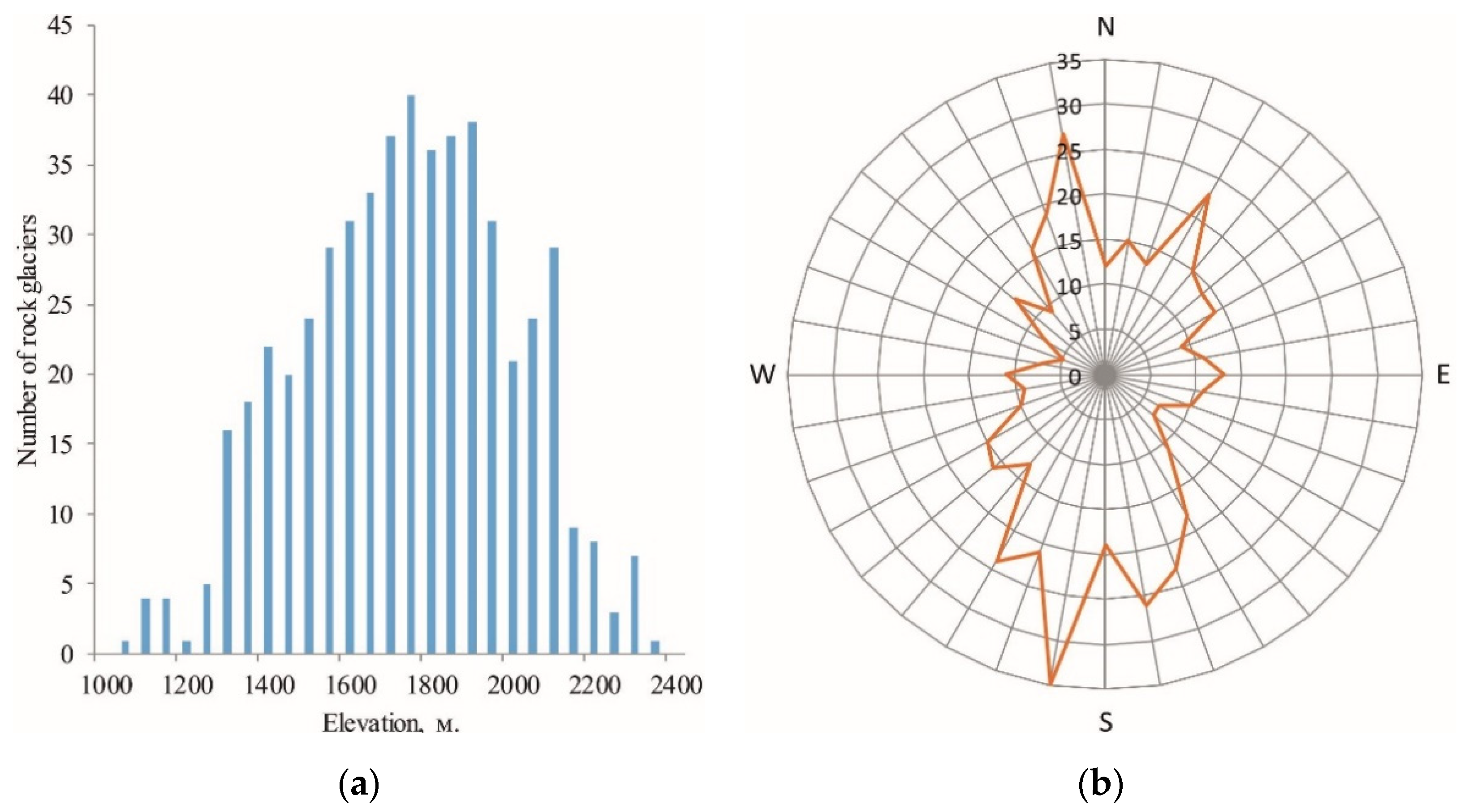
The performed studies are methodologically based on previous analyses on the mapping of rock glaciers of individual mountain regions of the world [12,38], as well as our studies of rock glaciers of the Suntar-Khayata Range [25]. To map the rock glaciers, we used the ArcGIS Online (ESRI) service, with Spot Image high-resolution satellite images and several Digital Globe products [39]. The resolution of satellite images is from 0.3 to 2.5 m/pixel. High-resolution space images were previously used for a number of areas of scientific research [40,41,42,43,44] and mapping rock glaciers in individual mountain regions [6,12,45,46].
Images are automatically loaded into a single raster layer for the entire area of the study area in ArcMap 10.1 software. For the decryption and mapping of other objects, Sentinel-2 satellite images with a resolution of 10 m obtained in the summer period were used [47]. These images were selected in such a way that they had the minimum allowable cloud cover—no more than 10%. The mapping process involved working with satellite image mosaics. The discovered rock glaciers were manually identified and digitized by georeferenced polygons in the vector layer [12,38]. For each rock glacier, the surface was digitized from the edge to the rear seam of the root slope [1,12,38]. Unlike previous authors [12,38], we calculated the surface area of a rock glacier, excluding slopes. There are several reasons for this, the first is the change in the area of the slope depending on the height of the rock glacier, which can sufficiently change the area of the rock glacier in nature. Second, the inclusion of rock glaciers in the total area of the slopes can lead to incorrect calculations of the ice content inside the rock glaciers, since under the slopes, according to our field observations, the ice content is very small. Since, the whole analysis was carried out by only one researcher, the uncertainties associated with identification and delineation were supposed to be consistent [48].
When mapping rock glaciers, we used the classification developed by D. Barsch [1], as well as some taxonomic names discussed in detail earlier [23,25]. In total, two types of rock glaciers were distinguished in relation to the surrounding relief (sloping, cirques).
Sloping rock glaciers form on the sides of the Pleistocene troughs, and they are well distinguished in space images. The front of the rock glaciers bends in the form of a crescent-shaped blade; systems of parallel Ranges appear on the surface. Each large blade of rock glaciers, as a rule, feeds from 1–2 talus cones. In areas of long steep slopes that feed many scree cones, many closely spaced rock-bladed glaciers are formed, some of which merge with the lateral edges, forming a complex multilobed rock glacier. Cirques rock glaciers form inside the corrie and resemble a glacier covered with a powerful cover of clastic material. Parallel Ranges of ramparts are formed on the surface, and some glacial orphosculptures are preserved: the marginal drainage channel, small firn basins, and sloping cracks (Figure 2).
To assess the altitude characteristics of rock glaciers, a digital terrain model GMTED2010 with a spatial resolution of 30 m was used [49]. The determination of the altitude of each rock glacier was carried out by assigning to it the values of a high-altitude raster in the form of additional attributes (Figure 2). The average absolute altitude and exposure were calculated from DEM using the ArcMap Spatial Analyst tool. These parameters were extracted in ArcMap for each pixel lying inside the polygon. The pixel values in each polygon were averaged using ArcMap Zonal Statistics.
As with previous studies [12], the degree of activity was determined while taking into account the estimated ice content, in accordance with the morphological classification of D. Barsch [1] and the use of geomorphological criteria in the interpretation of satellite images. In the catalog, they were divided into relict (not containing internal ice) and intact (containing ice). During interpretation, relict rock glaciers are distinguished on the surface on which a tuberous-pitted inversion microrelief is formed. It is formed after the thawing of ground ice. Moreover, the frontal slope of relict rock glaciers flattens on the surface; individual shrubs and trees begin to grow. Intact rock glaciers have a high and steep frontal ledge, which differs well in sickle shadows in aerospace images. The surface of the rock glaciers is composed of large coarse clastic material. In moving areas, it differs sharply with a darker photon from a steep front slope, which has a lighter tone. In addition, sickle ranges and depressions, which are formed as a result of deformations during its movement, are clearly distinguished on their surface. All of the above parameters were entered in the attributes table (Table 1).
Field studies to verify the results of mapping were carried out in the summer in the upper valleys of the River Kureter (the central part of the Chersky Range) and the River Burgali (the central part of the Suntar-Khayata Range). During field studies, the most typical rock glaciers for the key areas under investigation were described.

3. Results

A total of 4503 rock glaciers were mapped, with a total area of 224.6 km2, which are located within absolute altitudes, from 503 to 2496 m (Figure 3).

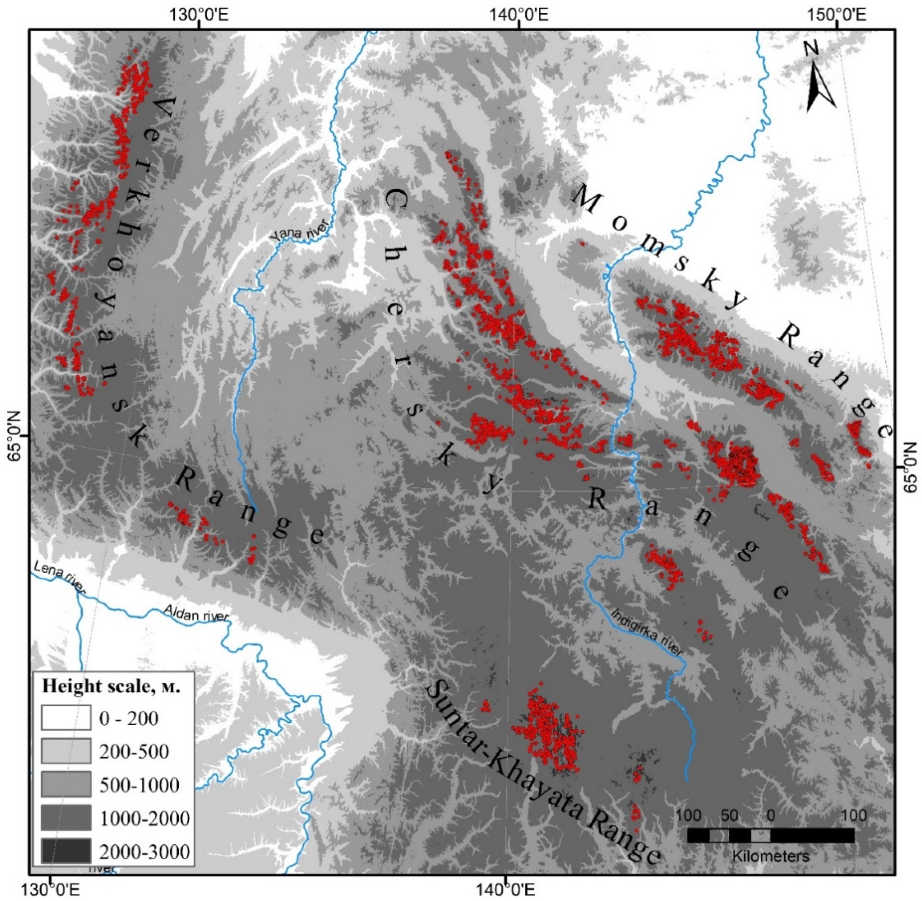
3.1. Distribution of Rock Glaciers on Mountain Ranges

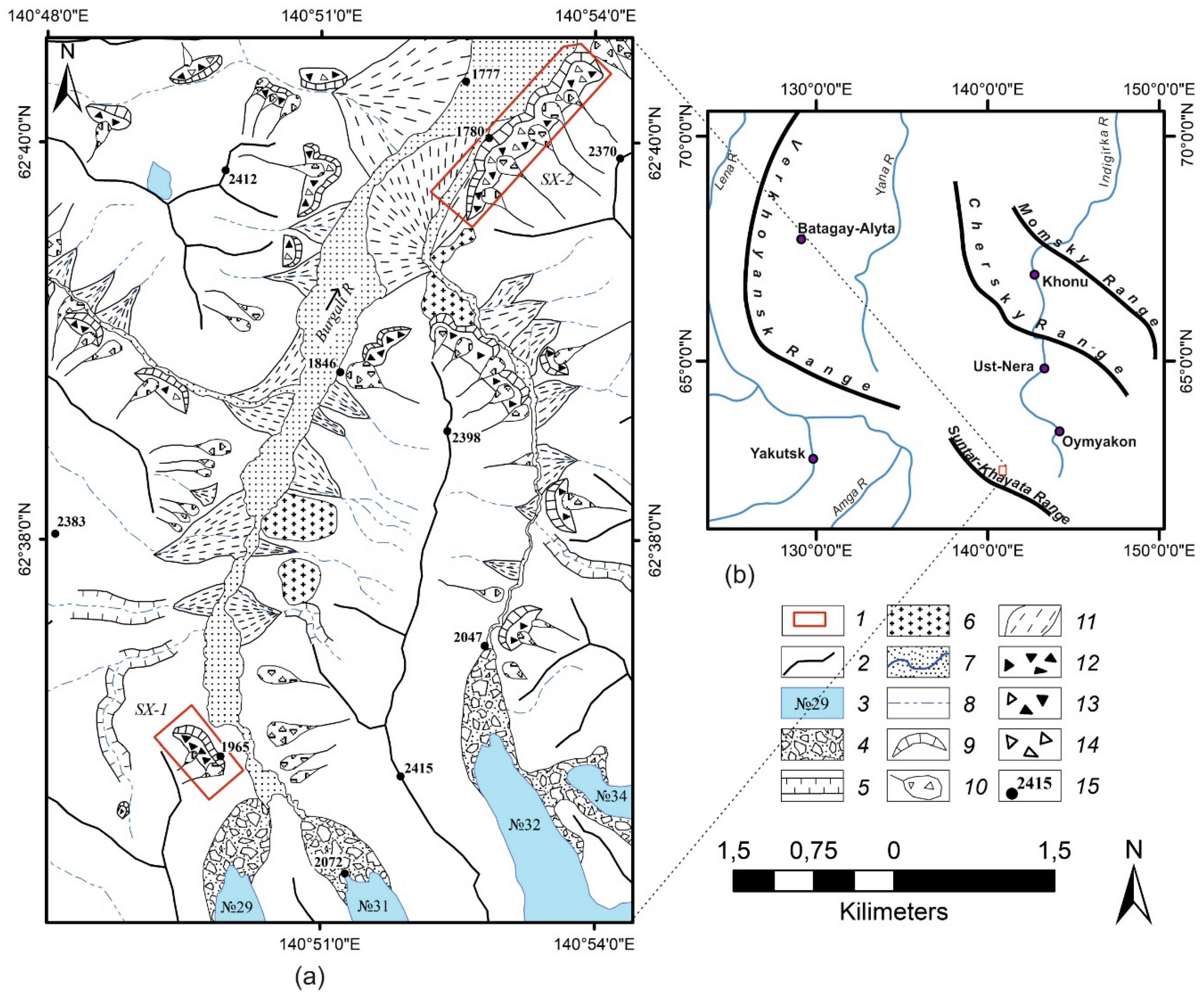
3.1.1. Suntar-Khayata Range

Within the Suntar-Khayat Range, we established 529 rock glaciers with a total area of 31.3 km2 (Table 2). In relation to the surrounding relief, 73 cirques and 456 sloping glaciers were established. In the cirque group, intact formations predominate, with only 2 relict formations. Among the sloping mappings, 286 multilobed rock glaciers and 405 intact were mapped. Sloping formations occupy 24.1 km2, which makes up 77% of the total area of rock glaciers (Table 2).
An analysis of the frequency distributions suggests that the rock glaciers of the region under consideration are distributed in the range of absolute altitudes of 1297–2402 m (Figure 4a). At the same time, the main part of rock glaciers is confined to an interval of 1600–2000 m. 53% of the total number of identified rock glaciers is located here. The average absolute altitudes of rock glaciers of different morphogenetic types are significantly different; cirques are located on average at an altitude of 2061 m, and sloping at 1755 m. An analysis of the frequency distributions of the exposure of the surrounding relief shows that they are mainly southwest- and northeast-oriented (Figure 4b). Some of the sites are located in the northwest.

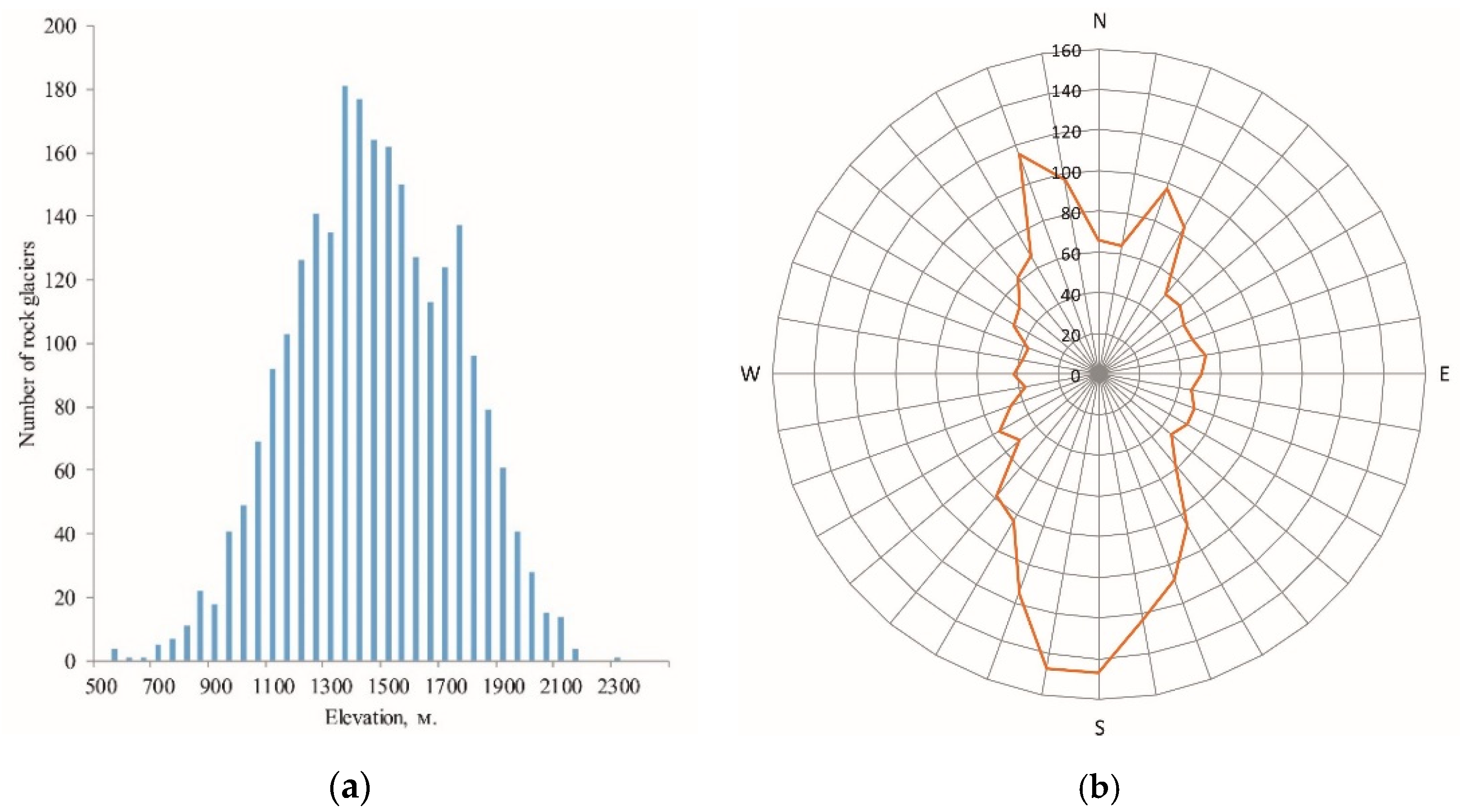
3.1.2. Chersky Range
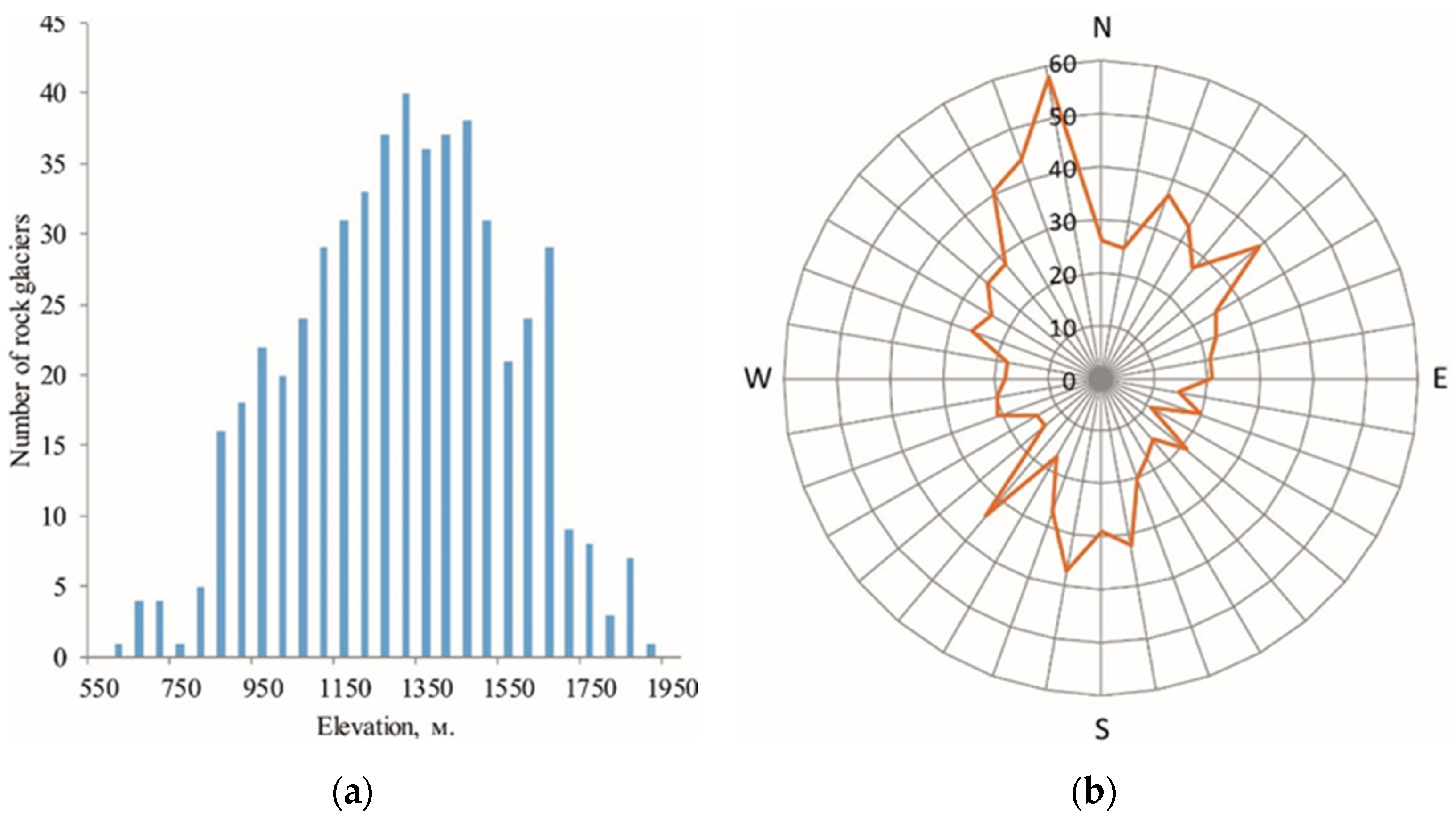
Notably, 2499 rock glaciers of various types were found on the territory of the Chersky Range. In relation to the surrounding relief, 309 rock glaciers belong to the cirque type and 2190 to the slope type. In the group of cirque rock glaciers, the majority are intact (301 formations), some of which consist of several generations of different ages superimposed on one another. In the group of sloping glaciers, 141 relict and 2049 intact relics were found. The total area of rock glaciers is 106.2 km2 (Table 3). Within the studied Range, the minimum area is 0.005 km2, the maximum is 1.25 km2, and the average is 0.04 km2.
The identified types of rock glaciers are located in the range of absolute altitudes of 550–2400 m (Figure 5a), and their maximum number is observed in the range of 1300–1900 m. Overall, 60% of all rock glaciers are located in this range of altitudes. Such altitudes are characteristic of the upper trough valleys. Generations of relict forms of rock glaciers are the most elevated (1716 m). Intact cirque formations are located at an altitude of 1712 m. The average absolute altitude of intact sloping rock glaciers is 1456 m; relict ones are 1254 m. An analysis of the frequency distributions of the exposure of the surrounding relief (Figure 5b) shows that most of the rock glaciers are located in the cirques and on the slopes of the southern and northern exposure.

3.1.3. Momsky Range

Notably, 926 rock glaciers with a total area of 50.5 km2 were mapped in the Momsky Range. Of these, 646 are sloping rock glaciers, and the number of cirque formations is 280 (Table 4). Overall, 67% of the sloping rock glaciers belong to multilobed formations. Among the sloping rock glaciers, 593 intact forms and 53 relict ones were revealed. Among the cirque s, 253 intact formations and 27 relict ones are mapped. Of the total area of rock glaciers, cirques occupy 42.6%. The average area of rock glaciers in the study area is 0.05 km2, the minimum value is 0.0006 km2, and the maximum area is fixed at the multilobed slope rock glacier and is 0.57 km2. The average values of the areas of the sloping and cirque rock glaciers differ significantly, 0.08 km2 of the sloping and 0.07 km2 cirque.
Interpreted rock glaciers are located in the range of absolute heights from 572 to 2210 m (Figure 6a). The main part is located in the range of absolute altitudes from 800 to 1600 m; 67% of the total number of rock glaciers are concentrated here, and they occupy an area equal to 30.3 km2. For sloping rock glaciers, the average absolute altitude is 1299 m, and the cirques are located at an absolute altitude of 1646 m. The highest are intact cirques of rock glaciers, the maximum heights of which reach 1743 m above sea level. Relict backbones spread to a height of just over 1000 m above sea level. Moreover, 58% of the total rock glaciers are concentrated on the northern slopes (Figure 6b), while 42% are on the southern slopes.

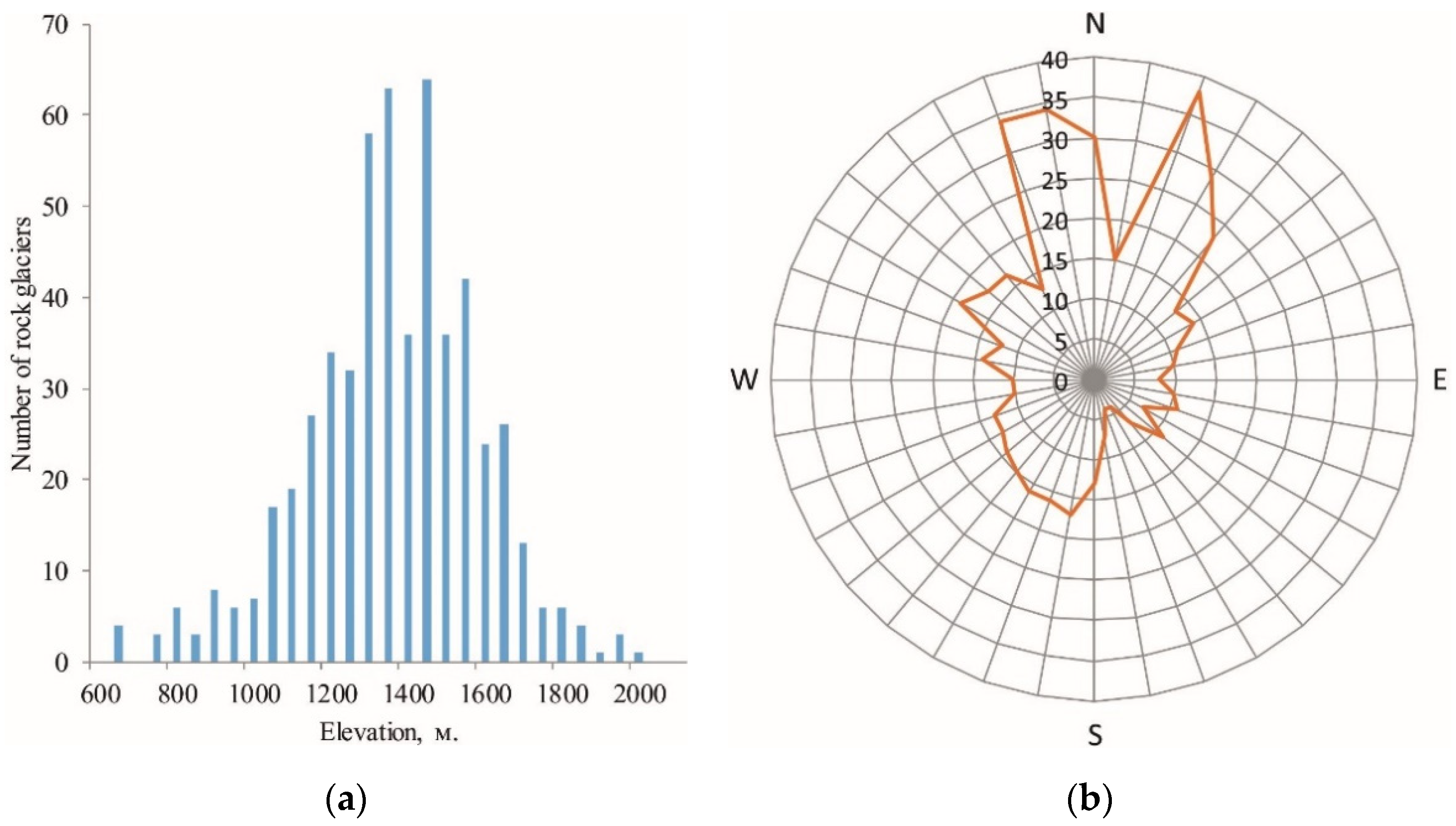
3.1.4. Verkhoyansky Range

A total of 552 rock glaciers with a total area of 36.6 km2 were identified in the Verkhoyansk Range (Table 5). No relict forms were found in this region; absolutely all identified formations have signs of intact rock glaciers. Most (64%) of the interpreted objects are located inside the cirques. The largest rock glacier has an area of 0.8 km2; it belongs to the slope type and consists of several blades. The average area of rock glaciers in the region is 0.06 km2.
The rock glaciers of this region lie in the range of absolute altitudes from 654 m to 2003 m, while 84% of the interpreted objects are in the range of absolute altitudes from 1100 to 1700 m (Figure 7a). The area of rock glaciers in this range is 30.9 km2. In the studied area, rock glaciers are located in the cirques and on the slopes of the northern and north-western exposure (64%) (Figure 7b).

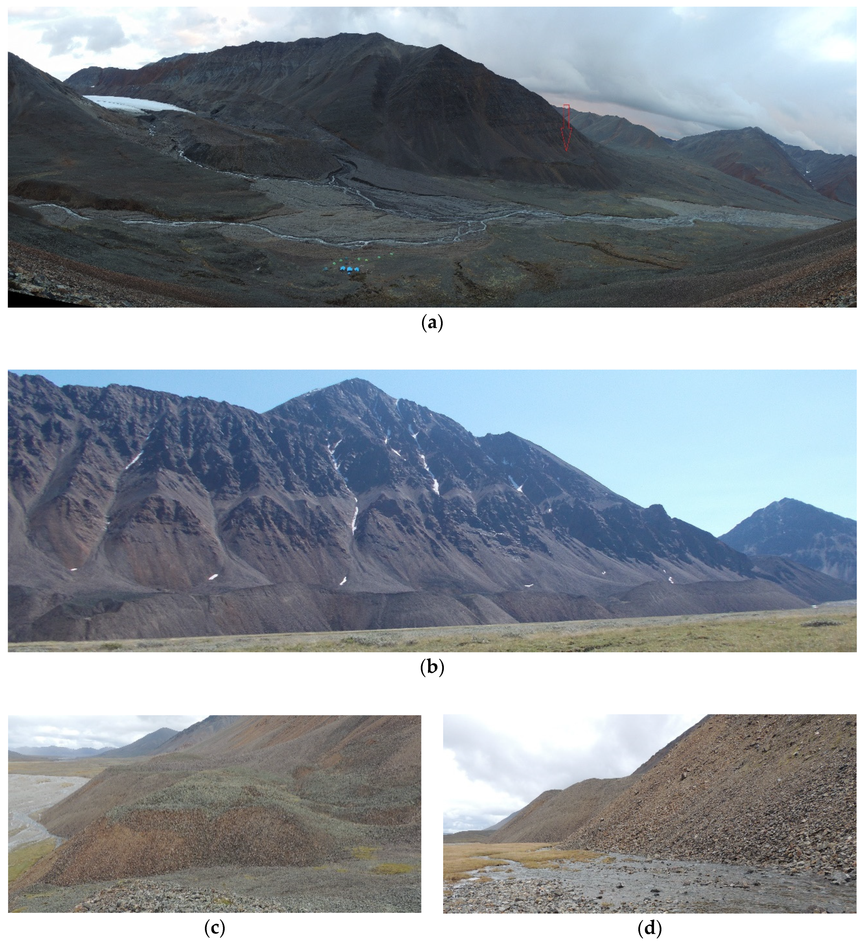
3.2. Field Observations

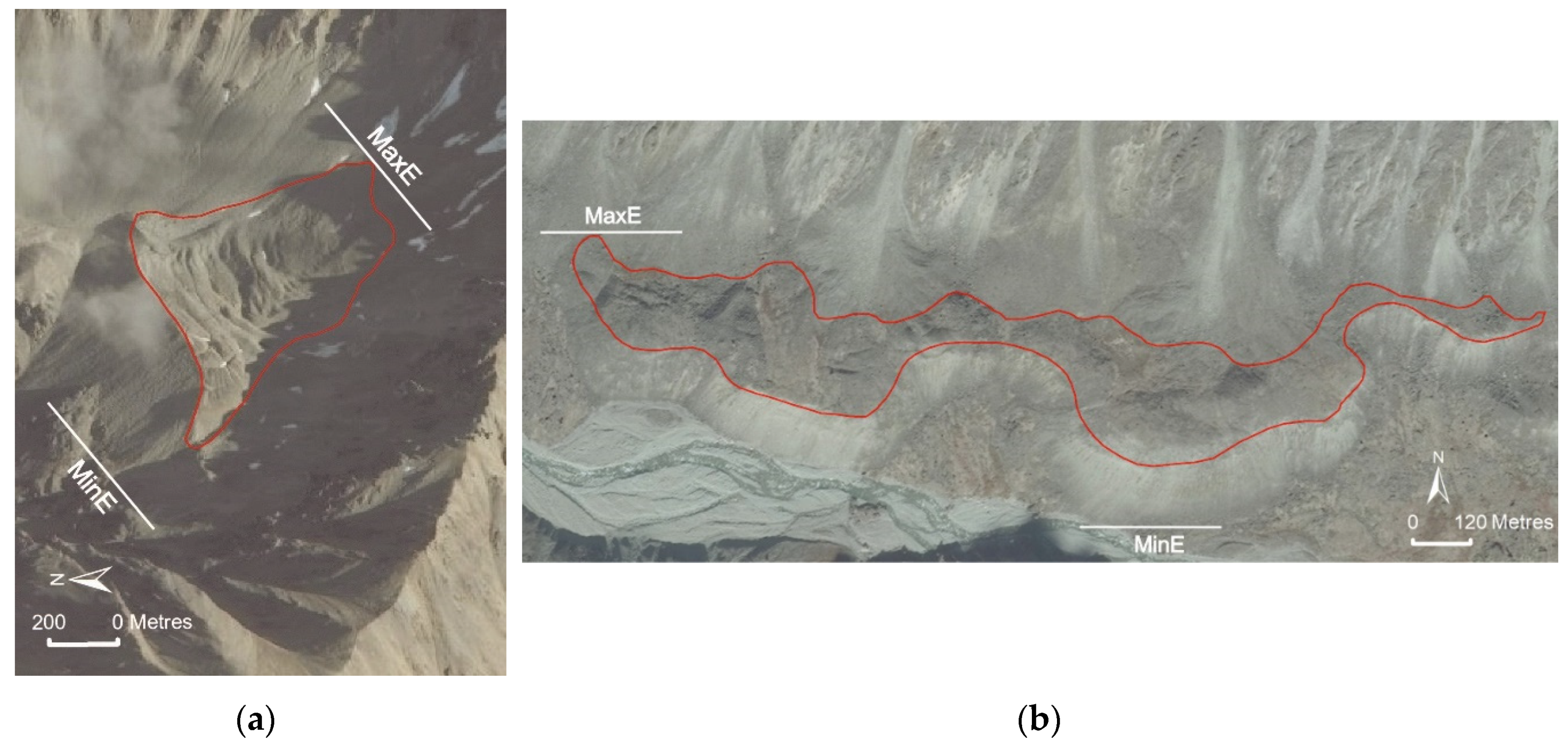
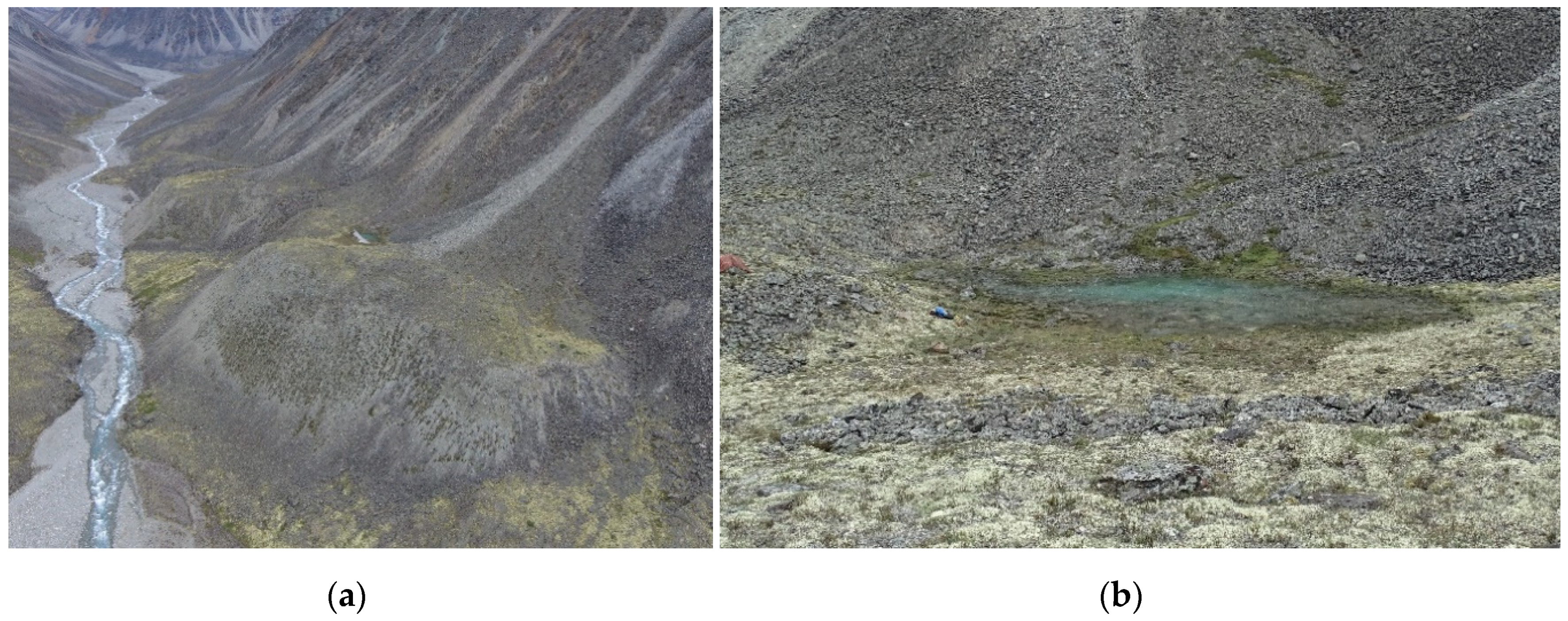
3.2.1. Morphology of Rock Glaciers of the Burgali River Basin

A field study of rock glaciers was carried out in the basin of the upper reaches of the River Burgali on the northern slope of Mus-Khaya (2959 m), in the central part of the Suntar-Khayata Range. Here at the source of the river, there are several large glaciers (Figure 8), the edge parts of which drop to altitudes of 2070–2100 m. Based on the analysis of aerospace data of different times, it was previously established that, at a distance of 400–600 m from the edges of the glaciers, there is an ice moraine belt of the small Little Ice Age [50]. Slope-type rock glaciers mark the sides of the trough valley at a distance of up to 8 km from the edge of the glaciers.
Mono-bladed sloping rock glacier No. SX-1 (62°37′ N; 140°49′ E) is located on the left side of the northeastern flank 1 km from the edge of glacier No. 29 in the altitude range of 1950–1980 m (Figure 8 and Figure 9a). It has a length of about 126 m, a width of 600 m, and a maximum thickness of 35–40 m. This glacier has the shape of a crescent moon, oriented with a convex part in the northeast direction. The feeding area is formed by a steep rocky slope of landslide-scree ablation. In the back of the glacier, there are two large avalanche talus cones. The steepness of the frontal slope varies from 40° to 55°; climbing is impossible. The surface of the glacier is slightly inclined towards the thalweg and is composed of crushed stone and block material of the Verkhoyansk Complex (strongly metamorphosed siliceous siltstones and sandstones). In high-resolution images, a network of polygonal cracks with a cell diameter of 15–20 m appears through a loose fragmentary rock glacier cover. The surface fragments are covered with a weathered crust 1–1.5 mm thick. The vegetation cover is represented exclusively by epiphytic lichens. Their projective cover varies from 5 to 20%. Large boulders from the edge of the frontal slope are randomly scattered at a distance of 20–30 m from the base of the rock glacier. Rock glacier No. SX-1 sharply overlaps the undulating, in some places tuberous-pitted surface of a cloak-like boulder-gravelly moraine, on the surface of which there are rare clumps of moss-herbaceous vegetation. In the northern part of the glacier, a small source emerges from under its frontal slope.
The multi-bladed sloping rock glacier No. SX-2 (62°39′ N; 140°52′ E) is located at a distance of about 8 km from the edge of glacier No. 31 on the right side of the River Burgali of the north-western exposure, in the altitude range of 1780–1820 m (Figure 8). It is formed by a series of merged blades up to 200 m long (Figure 9b), each of which feeds from 1–2 talus cones. The total width of the glacier reaches 1800 m, the area is 0.4 km2, and the maximum thickness is 70 m. Rock glacier crawls on the surface of the grassy-shrubby vegetation floodplain of River Burgali, whose height is 2–3 m. Its direct frontal slope with a steepness of 40–50° and a height of up to 70 m indicate a high activity. The edge and sole of the frontal slope are sinuous, which is associated with different activity and unequal speeds of movement of individual blades of this glacier. This is well reflected in the cover of lichens of the genus Rhizocarpon sp., which are completely absent in active sites of the frontal slope, and reach 20–30 cm in slow-moving ones.
This glacier is composed of angular gravel and large blocks of siltstones, shales and mudstones with isolated fragments of granitoids and tuffs. The surface is slightly inclined towards the thalweg of the River Burgali, has a tuberous-pitted microrelief and is broken by many multidirectional deep cracks, into which blocks and gravel are immersed (Figure 9c). The vegetation cover is formed by single curtains of mosses and bushy lichens. On the exposed fragments, the projective cover of scale lichens reaches 80–90%. Rhizocarpon sp. reach their maximum size (140–150 mm). The runoff of glacier No. SX-2 is carried out from several sources that merge and form a constant watercourse in summer (Figure 9d).

3.2.2. Morphology of Rock Glaciers of the Kureter River Basin

The Kureter River is located on the eastern slope of the Chersky Range; its sources originate from glaciers No. 18 (Figure 10). During fieldwork, we studied the morphometric and geomorphological characteristics of inactive rock glacier No. UC-1.
The multi-blade sloping rock glacier No. UC-1 (65°10′ N; 146°12′ E) is located in the middle reaches of the River Kureter, 9 km from Pobeda Peak, Sakha (3003 m), and represents inactive generation (Figure 11a). It is located on the left side of the northeastern exposure in the altitude range 1270–1310 m. It consists of two merged blades. The length of the first blade is 340 m; the second—270 m. Each blade is fed from one or two talus cones. The width of the rock glacier reaches 610 m; the maximum thickness is 50 m. The thickness of the rock glacier is determined using a measuring tape by measuring the distance from the lower point of the frontal ledge to the edge. The steepness of the frontal slope is 40–45°. The edge and sole of the front slope are sinuous. This glacier is composed of angular gravel and large clumps of liparite porphyry, lavobreccias, tuffites, sandstones, siltstones, shales, diabases, and gravelites, as well as late and early Cretaceous subvolcanic formations, represented by liparithic parfirs, granites, and granite porphyry. The surface is slightly inclined towards the thalweg of the River Kureter. It has a tuberous-pitted microrelief, and in some places, the surface of the rock glacier is broken by cracks, in which blocks and rubble are immersed. On the surface of the rock glacier, there is a thermokarst depression, the bottom of which is composed of finely dispersed (clay) deposits. In these depressions, small temporary reservoirs are formed, which appear during a period of heavy summer rainfall and spring snowmelt. On gently sloping areas, the surface of the rock glacier is weakly soddy; the thickness of the soil cover does not exceed 7 cm. Soddy areas are covered with moss; there are a few areas with sedge vegetation and a few cedar dwarf bushes (Figure 11b).

4. Discussion

As a result of the interpretation of satellite images, more than 4500 rock glaciers were identified, with a total area of 224.6 km2. Among the previously studied mountainous regions of the world (Table 6), the northeast of Yakutia is one of the largest areas of distribution of rock glaciers. This is facilitated by the presence of a continuous permafrost zone, with a thickness of 200 to 600 m and rock temperatures from −4 to −10.5 °C in the entire northeast of Yakutia [37]. In addition, one more important factor contributing to the formation of rock glaciers is a rather severe alpine climate. The mean annual temperatures in the studied mountain regions can drop to −14.0 °C, and the amount of precipitation at an altitude of 2000 m above sea level can reach up to 900 mm/year [27,30]. For example, in the Tatra mountain range [4], where the lowest intact marks of rock glaciers are noted in the European continent, the amount of precipitation can reach 1653 mm, and the mean annual temperature is −3.4 °C. The sharply continental climate also contributes to the rapid cryogenic weathering of rocks that feed rock glaciers [51]. As a rule, sloping rock glaciers studied in the field fed on several avalanche-talus cones, and the surface is composed, for the most part, of medium-sized boulders and rubble. On the other hand, the presence of a low-temperature permafrost zone and a harsh climate strongly affects the speed of rock glaciers. Thus, studies on the estimation of the speed of movement of rock glaciers of a sloping type in Svalbard have shown that they move at a speed of less than 1 cm/ye [52]. The morphology of the glaciers we studied is similar to their counterparts in Svalbard; this may indicate that here they also have low speeds. This is also evidenced by the presence of a fixed plot of meadow vegetation on the frontal slopes in many rock glaciers, which we observed during field studies (Figure 11a). For active ones, the speed of movement is very low, judging by the studied aerial photographs of the 1946s and modern ones. To estimate the displacement rate, we created orthomosaics using the UAV on several rock glaciers, but so far, we have not been able to get there for re-shooting.
In other mountainous regions of the world with an alpine type of permafrost, rock glaciers are indicators of the lower boundary of its distribution and therefore they cannot form below this boundary [7]. Table 6 shows not only the lower limit of the distribution of rock glaciers, but also the lower boundary of the development of permafrost. Here, rock glaciers are limited only by the incidence rate of the trough valleys and by the amount of precipitation depending on their latitude and altitude. So, in the work of A.A. Galanin [23] on the study of rock glaciers within the mountain structures of the north-eastern Asia, where permafrost is mostly continuous in temperatures of −1 to −3 °C, it was found that rock glaciers are confined to areas with precipitation of 500 mm/year and higher, and in areas where precipitation is less than 500 mm/year, rock glaciers were not found. Thus, in the Koryak Range, complex rock glaciers with firn basins are located at an altitude of 750–800 m, and to the north (in the Gydan and Anadyrsky Ranges), they are generally absent, although their altitude reaches 2000 m. In the region studied by us, rock glaciers have different altitudes of formation, moving from south to north. In the southernmost range (Suntar-Khayata Range), rock glaciers do not fall below 1500 m above sea level, and the average altitude here is the highest. Here, the lower elevations of the trough valleys can reach up to 1100 m above sea level. Meanwhile, in the Verkhoyansk Range, the average altitude of rock glaciers is 1386 m above sea level, and the minimum elevations of the trough valleys reach 600–700 m, but due to the small amount of precipitation at such altitudes, rock glaciers cannot form below 1200 m.
When examining the exposition of rock glaciers, it was shown that they exist mainly on the slopes facing north or south. In the Austrian and Swiss Alps, the preferred orientation of rock glaciers is mainly to the northwest and northeast, while in the Southern Alps, the dominant orientation is from south to southeast [1]. In the mountainous regions of North America and the Himalayas, rock glaciers are mostly north-oriented [46,48], while these formations are formed in the southern and southeastern slopes in South America [60]. In northeast Asia, in its Pacific basin, rock glaciers are located mainly on the slopes of the eastern and northeastern expositions [23].

5. Conclusions

The presented inventory of rock glaciers is the first for the studied mountain regions and presents their main statistical criteria. A total of 4503 rock glaciers were inventoried, with a total area of 224.6 km2. This indicator is one of the largest in relation to other mountain regions of the world.
The studied rock glaciers are located at absolute altitudes, from 503 to 2496 m above sea level. However, 69% of rock glaciers are concentrated in the altitude range from 1300 to 2000 m above sea level. The average area of the studied rock glaciers is 0.05 km2, the maximum area is 1.25 km2, while the area of the smallest rock glacier is 0.0005 km2. Most of the rock glaciers are located at the foot of the slopes of the trough valleys, forming sloping rock glaciers. There are 3595 of them and they occupy an area equal to 152.2 km2. Among the sloping areas, rock glaciers prevail, consisting of several blades (multi-lobe), reaching in length from the first hundred meters to 1 km. The distribution of rock glaciers over the mountain ranges is heterogeneous, 55% of the decrypted formations are located in the Chersky Range, 12.2% in the Verkhoyansk Range, 11.7% in the Suntar-Khayata Range and 5.5% in the Momsky Range.
The above results are the first report of rock glaciers in this region. Any information about them can make a significant contribution to the development of the theory of rock glaciers. Their further research should be focused on the study of their internal structure (ice content), since their potential impact on the flow of mountain rivers can be significant in this area.

Funding

The reported study was funded by Russian Foundation for Basic Research, project number 20-35-70027.

Conflicts of Interest

The authors declare no conflict of interest.

References

  1. Barsch, D. Rockglaciers: Indicators for the Present and Former Geoecology in High Mountain Environments; Springer Series in Physical Environment; Springer: Berlin, Germany, 1996. [Google Scholar]
  2. Colucci, R.R.; Boccali, C.; Žebre, M.; Guglielmin, M. Rock glaciers, protalus ramparts and pronival ramparts in the South-Eastern Alps. Geomorphology 2016, 269, 112–121. [Google Scholar] [CrossRef]
  3. Kellerer-Pirklbauer, A.; Rieckh, M. Monitoring nourishment processes in the rooting zone of an active rock glacier in an alpine environment. Z. Geomorphol. Suppl. 2016, 60, 99–121. [Google Scholar] [CrossRef]
  4. Uxa, T.; Mida, P. Rock glaciers in the Western and High Tatra Mountains, Western Carpathians. J. Maps 2017, 13, 844–857. [Google Scholar] [CrossRef] [Green Version]
  5. Fernandes, M.; Palma, P.; Lopes, L.; Ruiz-Fernández, J.; Pereira, P.; Oliva, M. Spatial distribution and morphometry of permafrost-related landforms in the Central Pyrenees and associated paleoclimatic implications. Quat. Int. 2018, 470, 96–108. [Google Scholar] [CrossRef]
  6. Rangecroft, S.; Harrison, S.; Anderson, K.; Magrath, J.; Castel, A.P.; Pacheco, P. A first rock glacier inventory for the Bolivian Andes. Permafr. Periglac. Process. 2014, 25, 333–343. [Google Scholar] [CrossRef]
  7. Azócar, G.F.; Brenning, A.; Bodin, X. Permafrost distribution modelling in the semi-arid Chilean Andes. Cryosphere 2017, 11, 877–890. [Google Scholar] [CrossRef] [Green Version]
  8. Esper Angillieri, M.Y. Permafrost distribution map of San Juan Dry Andes (Argentina) based on rock glacier sites. J. S. Am. Earth Sci. 2017, 73 (Suppl. C), 42–49. [Google Scholar] [CrossRef]
  9. Munroe, J.S. Distribution, evidence for internal ice, and possible hydrologic significance of rock glaciers in the Uinta Mountains, Utah, USA. Quat. Res. 2018, 90, 50–65. [Google Scholar] [CrossRef]
  10. Millar, C.; Westfall, R.D. Rock-glaciers and related periglacial landforms in the Sierra Nevada, CA, USA: Inventory, distribution and climatic relationships. Quat. Int. 2008, 188, 90–104. [Google Scholar] [CrossRef]
  11. Bolch, T.; Gorbunov, A.P. Characteristics and origin of rock glaciers in Northern Tien Shan (Kazakhstan/Kyrgyzstan). Permafr. Periglac. Process. 2014, 25, 320–332. [Google Scholar] [CrossRef] [Green Version]
  12. Jones, D.B.; Harrison, S.; Anderson, K.; Selley, H.L.; Wood, J.L.; Betts, R.A. The distribution and hydrological significance of rock glaciers in the Nepalese Himalaya. Glob. Planet. Chang. 2018, 160 (Suppl. C), 123–142. [Google Scholar] [CrossRef] [Green Version]
  13. Ran, Z.; Liu, G. Rock glaciers in Daxue Shan, south-eastern Tibetan Plateau: An inventory, their distribution, and their environmental controls. Cryosphere 2018, 12, 2327–2340. [Google Scholar] [CrossRef] [Green Version]
  14. Blöthe, J.H.; Rosenwinkel, S.; Höser, T.; Korup, O. Rock-glacier dams in High Asia. Earth Surf. Process. Landf. 2019, 44, 808–824. [Google Scholar] [CrossRef]
  15. Gorbunov, A.P.; Gorbunova, I.A. Geography of Rock Glaciers of the World; A Partnership of Scientific Editions KMK: Moscow, Russia, 2010. (In Russian) [Google Scholar]
  16. Gorbunov, A.P.; Gorbunova, I.A. Geography of Rock Glaciers and Their Analogues in Eurasia; Institute of Geography: Almaty, Kazakhstan, 2013. (In Russian) [Google Scholar]
  17. Sollid, J.L.; Etzelmuller, B. Soerbel, Rock Glaciers from Norway and Svalbard, Version 1; NSIDC—National Snow and Ice Data Center: Boulder, CO, USA, 1988. [Google Scholar] [CrossRef]
  18. Wahrhaftig, C.; Cox, A. Rock glaciers in the Alaska Range. Geol. Soc. Am. Bull. 1959, 70, 383–436. [Google Scholar] [CrossRef]
  19. Jones, D.B.; Harrison, S.; Anderson, K.; Betts, R.A. Mountain rock glaciers contain globally significant water stores. Sci. Rep. 2018, 8, 2834. [Google Scholar] [CrossRef] [PubMed] [Green Version]
  20. Jones, D.B.; Harrison, S.; Anderson, K.; Whalley, W.B. Rock glaciers and mountain hydrology: A review. Earth Sci. Rev. 2019, 193, 66–90. [Google Scholar] [CrossRef]
  21. Delaloye, R.; Barboux, C.; Bodin, X.; Brenning, A.; Hartl, L.; Hu, Y.; Ikeda, A.; Kaufmann, V.; Kellerer-Pirklbauer, A.; Lambiel, C.; et al. Rock glacier inventories and kinematics: A new IPA Action Group. In Proceedings of the 5th European Conference on Permafrost, Chamonix, France, 23 June–1 July 2018; Deline, P., Bodin, X., Ravenel, L., Eds.; Université Savoie Mont Blanc: Chamonix, France, 2018; pp. 392–393. [Google Scholar]
  22. Gorbunov, A.P. Rock glaciers of the Asian Russia. Earth’s Cryosphere 2006, 10, 22–28. (In Russian) [Google Scholar]
  23. Galanin, A.A. Rock glaciers of north-eastern Asia: Mapping and geographical analysis. Earth’s Cryosphere 2009, 13, 49–61. (In Russian) [Google Scholar]
  24. Galanin, A.A. Rock glaciers in the southern Chukchi Peninsula. Geomorfologiya 2017, 1, 66–79. (In Russian) [Google Scholar] [CrossRef] [Green Version]
  25. Lytkin, V.M.; Galanin, A.A. Rock glaciers in the Suntar-Khayata Range. Lëd Sneg 2016, 56, 511–524. (In Russian) [Google Scholar] [CrossRef] [Green Version]
  26. Ananicheva, M.D.; Kapystin, G.A.; Koreicha, M.M. Changing the glaciers in the Suntar-Khayata and Chersky mountains systems is assessed by Landsat imagery (2001 and 2003) and the USSR Glacier Inventory (published in 1970s). Data Glaciol. Stud. 2006, 101, 163–168. (In Russian) [Google Scholar]
  27. Grave, N.; Gavrilova, M.; Gravis, G.; Katasonov, E.; Klyukin, N.; Koreysha, G.; Kornilov, B.; Chistotinov, L. The Freezing of the Earth’s Surface and Glaciation on the Range Suntar-Khayata (Eastern Yakutia); Nauka: Moscow, Russia, 1964. (In Russian) [Google Scholar]
  28. Zhang, Y.; Wang, X.; Jiang, Z.; Wei, J.; Enomoto, H.; Ohata, T. Glacier Surface Mass Balance in the Suntar-Khayata Mountains, Northeastern Siberia. Water 2019, 11, 1949. [Google Scholar] [CrossRef] [Green Version]
  29. Zhang, Y.; Enomoto, H.; Ohata, T.; Kadota, T.; Shirakawa, T.; Tekeuchi, N. Surface Mass Balance on Glacier No. 31 in the Suntar–Khayata Range, Eastern Siberia, from 1951 to 2014. J. Mt. Sci. 2017, 14, 501–512. [Google Scholar] [CrossRef]
  30. Shirakawa, T.; Kadota, T.; Fedorov, A.; Konstantinov, P.; Suzuki, T.; Yabuki, H.; Nakazawa, F.; Tanaka, S.; Miyairi, M.; Fujisawa, Y.; et al. Meteorological and Glaciological Observations at Suntar-Khayata Glacier No. 31, East Siberia, from 2012–2014. Bull. Glaciol. Res. 2016, 34, 33–40. [Google Scholar] [CrossRef] [Green Version]
  31. Tanaka, S.; Takeuchi, N.; Miyairi, M.; Fujisawa, Y.; Kadota, T.; Shirakawa, T.; Kusaka, R.; Takahashi, S.; Enomoto, H.; Ohata, T.; et al. Snow Algal Communities on Glaciers in the Suntar-Khayata Mountain Range in Eastern Siberia, Russia. Polar Sci. 2016, 10, 227–238. [Google Scholar] [CrossRef]
  32. Takeuchi, N.; Fujisawa, Y.; Kadota, T.; Tanaka, S.; Miyairi, M.; Shirakawa, T.; Kusaka, R.; Fedorov, A.; Konstantinov, P.; Ohata, T. The Effect of Impurities on the Surface Melt of a Glacier in the Suntar-Khayata Mountain Range, Russian Siberia. Front. Earth Sci. 2015, 3, 82. [Google Scholar] [CrossRef] [Green Version]
  33. Takahashi, S.; Sugiura, K.; Kameda, T.; Enomoto, H.; Kononov, Y.; Ananicheva, M.; Kapustin, G. Response of Glaciers in the Suntar-Khayata Range, Eastern Siberia, to Climate Change. Ann. Glaciol. 2011, 52, 185–192. [Google Scholar] [CrossRef] [Green Version]
  34. Galanin, A.A.; Lytkin, V.M.; Fedorov, A.N.; Kadota, T. Recession of glaciers in the Suntar-Khayata Mountains and methodological consideration of its assessment. Ice Snow 2013, 4, 30–42. [Google Scholar] [CrossRef]
  35. Ananicheva, M.D.; Karpachevsky, A. Glaciers of the Orulgan Range: Assessment of the current state and possible development for the middle of the 21st century. Environ. Earth Sci. 2015, 74, 1985–1995. [Google Scholar] [CrossRef]
  36. Nekrasov, I.A.; Sheikman, V.S. USSR Glacier Inventory. V. 17. Is/7. Pt. 2,4. V. 17. Pt. 4.; Hydrometeoizdat: Leningrad, Russia, 1981. (In Russian) [Google Scholar]
  37. Nekrasov, I.A.; Maksimov, E.V.; Klimovskiy, I.V. The Last Glaciation and Permafrost in the Southern Verkhoyansk Range; Knizhnoe izdatel’stvo: Yakutsk, Russia, 1973. (In Russian) [Google Scholar]
  38. Pandey, P. Inventory of rock glaciers in Himachal Himalaya, India using high-resolution Google Earth imagery. Geomorphology 2019, 340, 103–115. [Google Scholar] [CrossRef]
  39. ESRI ArcGIS. Available online: https://www.arcgis.com/home/item.html?id=10df2279f9684e4a9f6a7f08febac2a9 (accessed on 2 March 2020).
  40. Maglione, P.; Parente, C.; Vallario, A. Coastline extraction using high-resolution WorldView-2 satellite imagery. Eur. J. Remote Sens. 2014, 47, 685–699. [Google Scholar] [CrossRef]
  41. Mutanga, O.; Adam, E.; Cho, M.A. High-density biomass estimation for wetland vegetation using WorldView-2 imagery and random forest regression algorithm. Int. J. Appl. Earth Obs. Geoinf. 2012, 18, 399–406. [Google Scholar] [CrossRef]
  42. Pu, R.; Landry, S. A comparative analysis of high spatial resolution IKONOS and WorldView-2 imagery for mapping urban tree species. Remote Sens. Environ. 2012, 124, 516–533. [Google Scholar] [CrossRef]
  43. Immitzer, M.; Atzberger, C.; Koukal, T. Tree Species Classification with Random Forest Using Very High Spatial Resolution 8-Band WorldView-2 Satellite Data. Remote Sens. 2012, 4, 2661–2693. [Google Scholar] [CrossRef] [Green Version]
  44. Aguilar, M.A.; Saldaña, M.M.; Aguilar, F.J. GeoEye-1 and WorldView-2 pan-sharpened imagery for object-based classification in urban environments. J. Remote Sens. 2013, 34, 2583–2606. [Google Scholar] [CrossRef]
  45. Charbonneau, A.A.; Smith, D.J. An inventory of rock glaciers in the central British Columbia Coast Mountains, Canada, from high-resolution Google Earth imagery. Arct. Antarct. Alp. Res. 2018, 50. [Google Scholar] [CrossRef] [Green Version]
  46. Schmid, M.-O.; Baral, P.; Gruber, S.; Shahi, S.; Shrestha, T.; Stumm, D.; Wester, P. Assessment of permafrost distribution maps in the Hindu Kush Himalayan region using rock glaciers mapped in Google Earth. Cryosphere 2014, 9, 2089–2099. [Google Scholar] [CrossRef] [Green Version]
  47. Copernicus Open Access Hub. Available online: https://scihub.copernicus.eu/dhus (accessed on 2 March 2020).
  48. Brardinoni, F.; Scotti, R.; Sailer, R.; Mair, V. Evaluating sources of uncertainty and variability in rock glacier inventories. Earth Surf. Process. Landf. 2019, 44, 2450–2466. [Google Scholar] [CrossRef]
  49. U.S. Geological Survey. Available online: https://earthexplorer.usgs.gov/ (accessed on 2 March 2020).
  50. Galanin, A.A.; Lytkin, V.M.; Fedorov, A.N.; Kadota, T. Age and extent of the Last Glacial Maximum in the Suntar-Khayata Range based on lichenometry and Schmidt Hammer Test. Earth Cryosphere 2014, 18, 72–83. (In Russian) [Google Scholar]
  51. Haeberli, W.; Hallet, B.; Arenson, L.; Elconin, R.; Humlum, O.; Kääb, A.; Kaufmann, V.; Ladanyi, B.; Matsuoka, N.; Springman, S.M. Permafrost creep and rock glacier dynamics. Permafr. Periglac. Process. 2006, 17, 189–214. [Google Scholar] [CrossRef]
  52. Kääb, A.; Isaksen, K.; Eiken, T.; Farbrot, H. Geometry and dynamics of two lobe-shaped rock glaciers in the permafrost of Svalbard. Nor. Geogr. Tidsskr.-Nor. J. Geogr. 2002, 56, 152–160. [Google Scholar] [CrossRef] [Green Version]
  53. Seligman, Z.M.; Klene, A.E.; Nelson, F.E. Rock glaciers of the Beartooth and northern Absaroka ranges, Montana, USA. Permafr. Periglac. Process. 2019, 30, 249–259. [Google Scholar] [CrossRef]
  54. Janke, J.R. Colorado Front Range Rock Glaciers: Distribution and Topographic Characteristics. Arct. Antarct. Alpine Res. 2007, 39, 74–83. [Google Scholar] [CrossRef] [Green Version]
  55. Selley, H.; Harrison, S.; Glasser, N.; Wündrich, O.; Colson, D.; Hubbard, A.L. Rock glaciers in central Patagonia. Geogr. Ann. Ser. A Phys. Geogr. 2019, 101, 1–15. [Google Scholar] [CrossRef] [Green Version]
  56. Janke, J.R.; Ng, S.; Bellisario, A. An inventory and estimate of water stored in firn fields, glaciers, debris-covered glaciers, and rock glaciers in the Aconcagua River Basin, Chile. Geomorphology 2017, 296, 142–152. [Google Scholar] [CrossRef]
  57. García, A.; Ulloa, C.; Amigo, G.; Milana, J.P.; Medina, C. An inventory of cryospheric landforms in the arid diagonal of South America (high Central Andes, Atacama Region, Chile). Quat. Int. 2017, 438, 4–19. [Google Scholar] [CrossRef]
  58. Falaschi, D.; Masiokas, M.; Tadono, T.; Couvreux, F. ALOS-derived glacier and rock glacier inventory of the Volcán Domuyo region (~36° S), southernmost Central Andes, Argentina. Z. Geomorphol. 2016, 60, 195–208. [Google Scholar] [CrossRef]
  59. Falaschi, D.; Tadono, T.; Masiokas, M.H. Rock glaciers in the patagonian andes: An inventory for the monte san lorenzo (cerro cochrane) massif, 47° s. Geogr. Ann. Ser. A Phys. Geogr. 2015, 97, 769–777. [Google Scholar] [CrossRef]
  60. Falaschi, D.; Castro, M.A.; Masiokas, M.H.; Tadono, T.; Ahumada, A.L. Rock Glacier Inventory of the Valles Calchaquíes Region (~25°S), Salta, Argentina, Derived from ALOS Data. Permafr. Periglac. Process. 2014, 25, 69–75. [Google Scholar] [CrossRef]
  61. Onaca, A.; Ardelean, F.; Urdea, P.; Magori, B. Southern Carpathian rock glaciers: Inventory, distribution and environmental controlling factors. Geomorphology 2017, 293, 391–404. [Google Scholar] [CrossRef]
  62. Seppi, R.; Carton, A.; Zumiani, M.; Dall’Amico, M.; Zampedri, G.; Rigon, R. Inventory, distribution and topographic features of rock glaciers in the southern region of the Eastern Italian Alps (Trentino). Geogr. Fisica E Din. Quat. 2012, 185–197. [Google Scholar] [CrossRef]
  63. .Baroni, C.; Carton, A.; Seppi, R. Distribution and behaviour of rock glaciers in the Adamello-Presanella Massif (Italian Alps). Permafr. Periglac. Process. 2004, 15, 243–259. [Google Scholar] [CrossRef]
  64. Krainer, K.; Ribis, M. A Rock Glacier Inventory of the Tyrolean Alps (Austria). Austrian J. Earth Sci. 2012, 105, 32–47. [Google Scholar]
  65. Wang, X.; Liu, L.; Zhao, L.; Wu, T.; Li, Z.; Liu, G. Mapping and inventorying active rock glaciers in the northern Tien Shan of China using satellite SAR interferometry. Cryosphere 2016, 11, 997–1014. [Google Scholar] [CrossRef] [Green Version]
Figure 1. Map of the research area (b). The black lines indicate the watershed parts of the mountain ranges (a).
Land 09 00384 g001
Figure 2. Example of deciphering (red line) the surface of cirque (a) and sloping rock glaciers (b), measuring the minimum (MinE) maximum (MaxE) elevations.
Land 09 00384 g002
Figure 3. Distribution of rock glaciers in the study area. Mapped rock glaciers are indicated with red circles.
Land 09 00384 g003
Figure 4. Distribution of mean absolute altitudes (a) and the exposure of the slopes (b) of rock glaciers on the Suntar-Khayat Range.
Land 09 00384 g004
Figure 5. Distribution of mean absolute altitudes (a) and exposure of slopes (b) of rock glaciers on Chersky Range.
Land 09 00384 g005
Figure 6. Distribution of mean absolute altitudes (a) and exposure of slopes (b) and rock glaciers of the Momsky Range.
Land 09 00384 g006
Figure 7. Distribution of mean absolute altitudes (a) and exposure of slopes (b) and rock glaciers of the Verkhoyansk Range.
Land 09 00384 g007
Figure 8. The key research site on the Suntar-Khayata Range is marked with a red square (b). Glacial-periglacial complexes in the Burgali River valley (a). 1—footslope multi-lobe rock glacier No. SX-1 and SX-2; 2—Range crests; 3—glaciers as numbered according to the USSR Glacier Inventory; 4—Late Holocene moraines; 5—erosional cliffs; 6—riegels; 7—floodplain and channel of modern streams; 8—temporary streams; 9—steep fronts of rock glaciers; 10—avalanche talus cones; 11—proluvial cones; 12—surface of active rock glaciers; 13—surface of inactive rock glaciers; 14—surface of relict rock glaciers; 15—altitudes.
Land 09 00384 g008
Figure 9. Footslope rock glaciers in the Burgali River Valley, Suntar-Khayata Range. (a)—SX-1, an active rock glacier at 1965 m asl; (b)—SX-2, a partially active footslope rock glacier at 1780 m asl; (c)—surface of SX-2 rock glacier; (d)—lobes of SX-2 extensive rock glacier.
Land 09 00384 g009
Figure 10. The key research site on the Chersky Range is marked with a red square (b). Glacial-periglacial complexes in the Kureter River valley (a). 1—footslope multi-lobe rock glacier No. UC-1; 2—Range crests; 3—glaciers as numbered in the USSR Glacier Inventory; 4—Late Holocene moraines; 5—erosional cliffs; 6—riegels; 7—floodplain and channel of modern streams; 8—temporary streams; 9—steep fronts of rock glaciers; 10—avalanche talus cones; 11—proluvial cones; 12—surface of active rock glaciers; 13—surface of inactive rock glaciers; 14—surface of relict rock glaciers; 15—altitudes.
Land 09 00384 g010
Figure 11. Morphology of rock glacier No. UC-1 (a) and a temporary lake on its surface (b), which forms during heavy precipitation.
Land 09 00384 g011
Table 1. Attributes derived for the inventory of the rock glaciers.
AttributeMeaning
RG IDRock glacier number
Area (km2)Total area of the rock glacier
Min Ele (m asl)Minimum elevation of the front of the rock glacier
Max Ele (m asl)Maximum elevation of the rock glacier
Mean EleMean elevation of the rock glacier
AspectMajor aspect of the rock glacier in degrees
LocationTerrain location (cirque, sloping)
ComplexityNumber of blades of rock glaciers (mono-or multi-lobed)
Dynamic TypeSeverity of the relief (relict and intact)
Table 2. Statistics of Rock Glaciers of the Suntar-Khayata Range.
Type of Rock GlacierQuantityArea (km2)Area (%)Mean Elevation, m AslMinE, m AslMaxE, m Asl
Slope:45624.177.0177517451808
Intact40518.860.0179917701831
Relict515.317.0158415501624
Cirque:737.223.0206120022126
Intact717.122.7206720072133
Relict20.10.3185518181880
Total52931.3 181517801825
Table 3. Statistics of Rock Glaciers of the Chersky Range.
Type of Rock Glacier QuantityArea (km2)Area (%)Mean Elevation, m AslMinF, m AslMaxE, m Asl
Slope:219083.678.7144314171472
Intact204974.269.9145614301482
Relict1419.48.9125412231288
Cirque:30922.621.3171216601766
Intact30121.520.2171216611766
Relict81.11.0171616561777
Total2499106.2 147614471508
Table 4. Statistics of Rock Glaciers of the Momsky Range.
Type of Rock Glacier QuantityArea (km2)Area (%)Mean Elevation, m AslMEF, m AslMaxE, m Asl
Slope:64629.057.4129912711331
Intact59325.650.7132612982358
Relict433.46.79999681036
Cirque:28021.542.6164615831708
Intact25319.538.6167916151743
Relict272.04.0133612841385
Total92650.5 140413652214
Table 5. Statistics of Rock Glaciers of the Verkhoyansk Range.
Type of Rock Glacier QuantityArea (km2)Area (%)Mean Elevation, m AslMEF, m AslMaxE, m Asl
Slope (Intact)19815.542.3131712821354
Cirque (Intact)35421.157.7147114101536
Total55236.6 138613401436
Table 6. Statistical Parameters of Rock Glaciers of the World.
Research AreaAuthorArea (km2)NumberDynamic TypeMean Elev., m a.s.l.Min n Elev., mMax elev., m
Absaroka (North America)Seligman Z. et al. [53]-270all types 273220933072
Beartooth (North America)Seligman Z. et al. -391all types292922393443
Colorado Front Range (North America)Janke J. [54]19.9220active 359435253668
inactive347734243541
fossil328832273358
Sierra Nevada (North America)Millar C. et al. [10]-289cirque332432423405
valley wall324332013285
Central British Columbia Coast Mountains (North America)Charbonneau A. et al. [46]-165intact2195--
Uinta Mountains (North America) Munroe J. [9]-395all types328532433341
Central Patagonia (South America)Selley H. et al. [55]14.1889intact 17661941
relict 17581919
Aconcagua River Basin (South America)Janke J. et al. [56]70.0669all types381023704565
Central Andes (Atacama region) (South America)Garcia A. et al. [57]44.34477all types442738075504
San Juan Dry Andes (South America)Esper Angillieri M. Y. [8]-526all types4106--
Chilean Andes (South America)Azocar G. et al. [7]-3575 ---
Volcán Domuyo region (~36° S), southernmost Central Andes (South America)Falaschi D. et al. [58]17.7224active304739682664
inactive282135262165
relict264433401955
Monte San Lorenzo massif (South America) Falaschi D. et al. [59]11.31177intact174221551335
fossil159020301267
Valles Calchaquíes Region (South America)Falaschi D. et al. [60]58.5488intact487359084183
fossil469553974072
Western Tatra Mts. (Europe)Uxa T. [4]7.14183intact-1812-
relict-1644-
High Tatra Mts. (Europe)Uxa T. [4]6.7200intact-2011-
relict-1731-
Southern Carpathian (Europe)Onaca A. et al. [61]12.7306all types1998--
Southern regionof the eastern Italian Alps (Europe)Seppi R. et al. [62]33.3705intact263230822716
relict266921691644
South-eastern Alps (Europe)Colucci R. et al. [2] 3.4553all types1778--
Adamello-Presanella Massif (Italian Alps) (Europe)Baroni C. et al. [63]-216all types-23492232
Tyrolean Alps (Europe)Krainer K. et al. [64]167.23145active270427972628
inactive259826652542
fossil233023842279
Nepalese Himalaya (Asia)Jones D. et al. [12] 249.836239intact 52154977
relict 47384541
Himachal Himalaya (Asia)Pandey P. [38]353516all types-49004484
TienShan of China (Asia)Wang X. et al. [65]91.5261all types-34863174
Daxue Shan, south-eastern Tibetan Plateau (Asia)Ran Z. et al. [13]55.70295all types4471-4352
Karakoram, Tien Shan, Altai (Asia)Blothe J. et al. [14]4522082----

