Where Do Ecosystem Services Come From? Assessing and Mapping Stakeholder Perceptions on Water Ecosystem Services in the Muga River Basin (Catalonia, Spain)


Abstract
1. Introduction
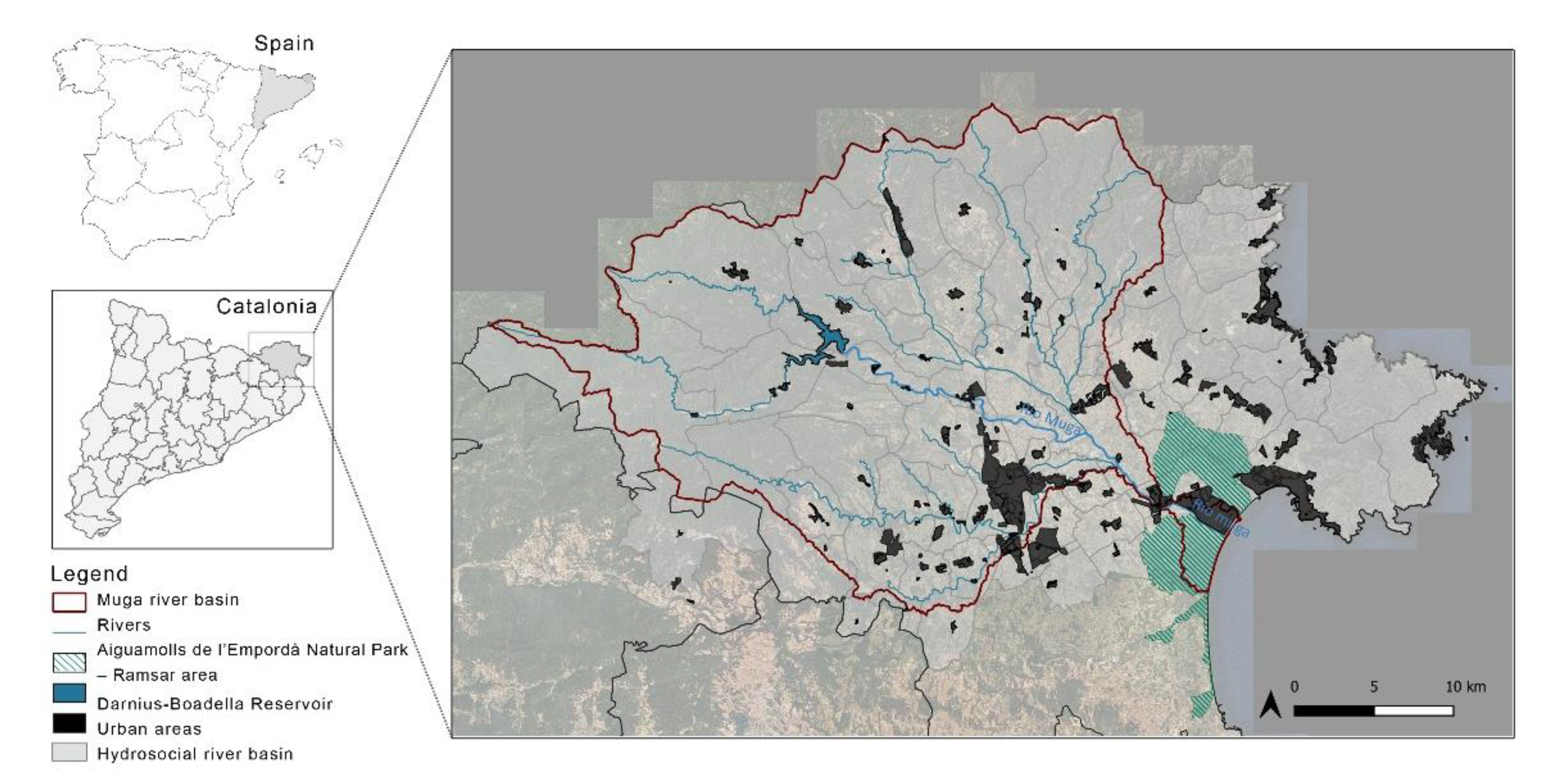
2. Study Area
3. Materials and Methods
3.1. Identification of WES by an Expert Panel
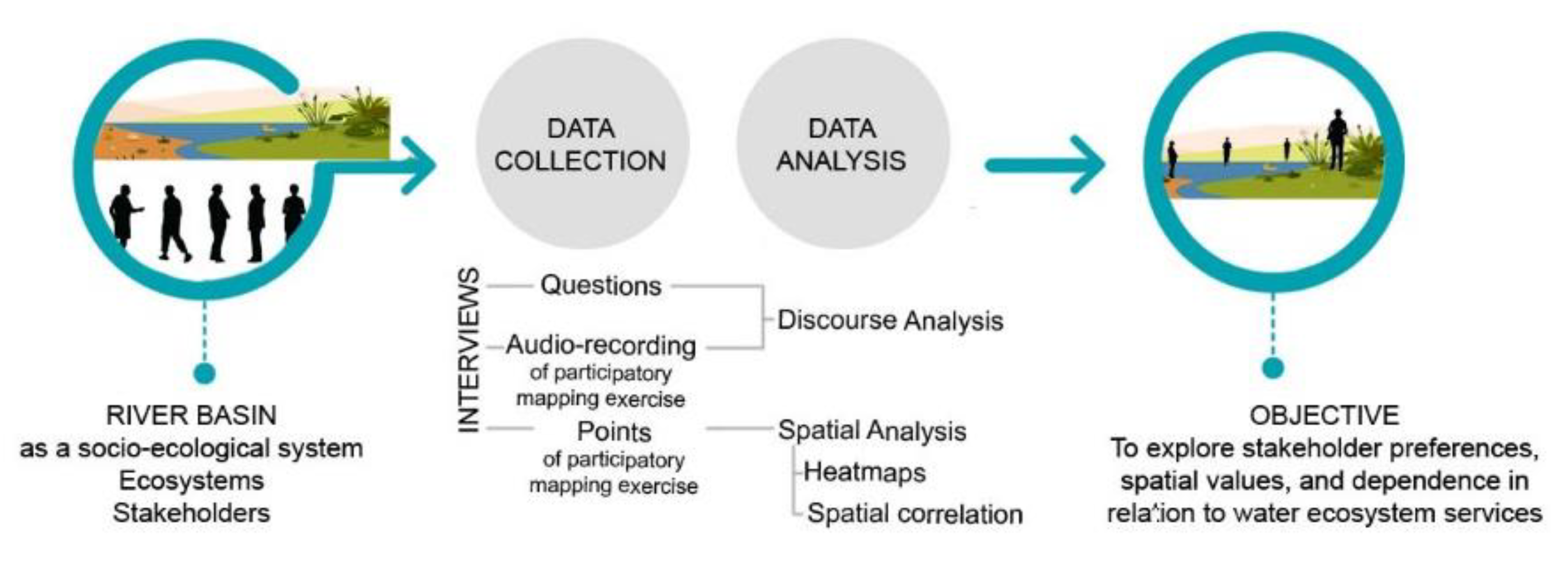
3.2. Data Collection: Interview Design, Sampling, and Participatory Mapping
3.3. Data and Content Analysis
3.4. Spatial Data Analysis
4. Results and Discussion
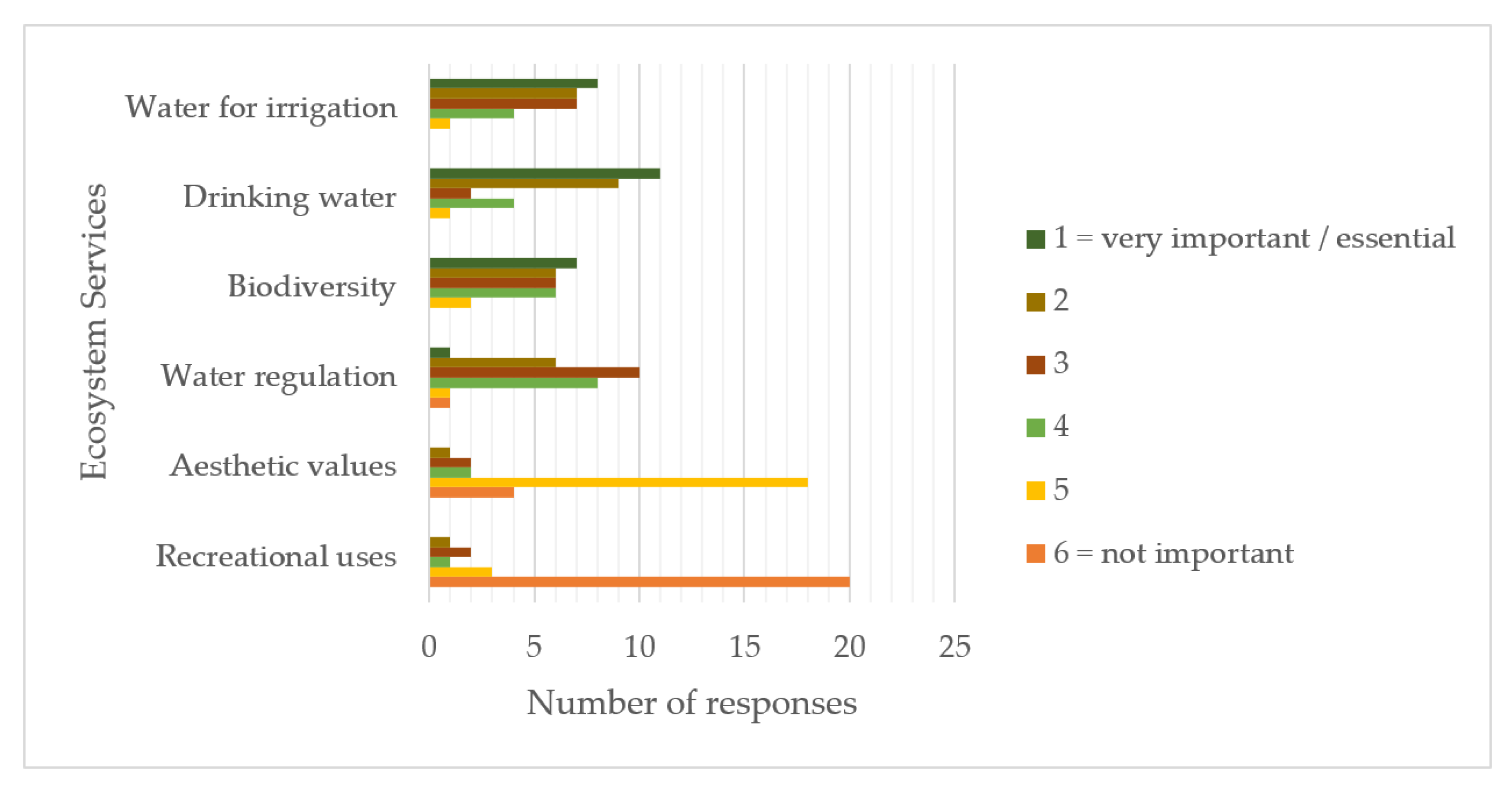
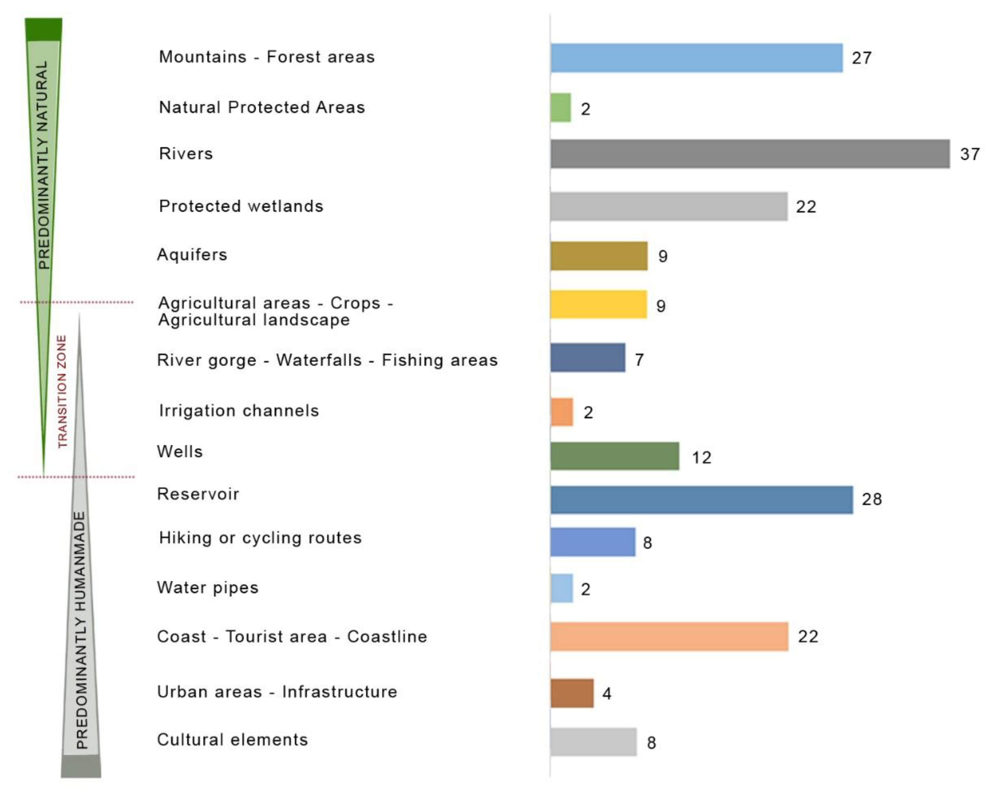
4.1. Identification of the Most Important WES
“We like this landscape that has been embellished by the hand of man. It is our cultural landscape, it’s what makes the Alt Empordà beautiful; This area is like the Garden of Eden, it has everything, it offers all the resources we need, it’s wonderful. I’m in love with it”.
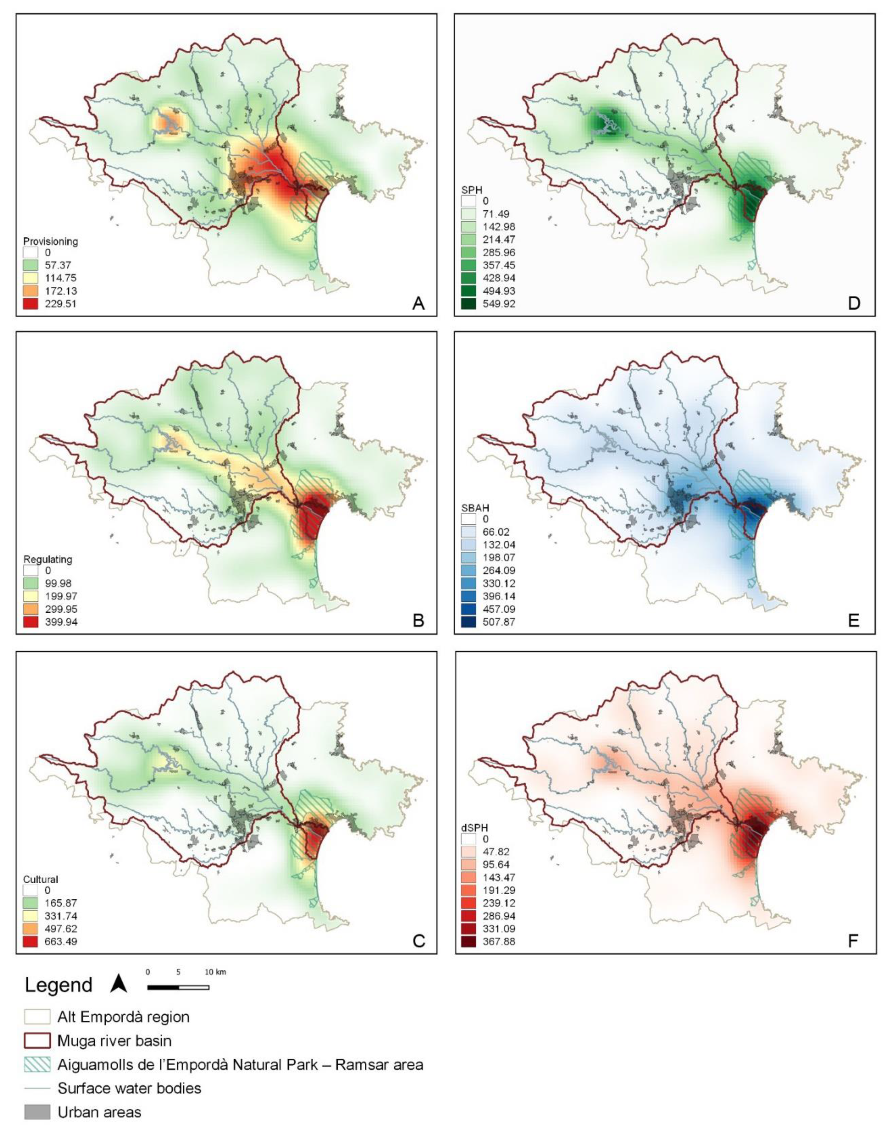
4.2. Social Perceptions and Spatial Distribution of WES
“All the water from the reservoir goes to agriculture; the levels drop to dramatic levels two months a year and all the water is used for agriculture; there’s no water in the river the rest of the year, we’re outraged, they’re throwing it away”.
“When there’s a drought, priority is given to urban and tourism uses, and we’re the ones who are most affected. We’re the only ones who change what we do to use water more efficiently, for example, by planting crops that are more suited to the effects of climate change (temperature, rain, wind, humidity”.
“More and more water is needed for general consumption and tourism; the entire coastline consumes a lot of water here in summer. The thing is, this area has always been agricultural; tourism came later and water that used to be for agriculture has been extracted from the aquifers and now there is less. The need for water has increased, but there is no control, nobody is looking at how many showers tourists are taking a day, for example. But everything we do is controlled. But in our case, a high proportion of the water we use goes back to the aquifer”.
5. Conclusions
“If only the most influential actors put points where they want, lying about reality and their behaviors, and influencing the weakest, they’ll end up making their own interests prevail, like always”.
Author Contributions
Funding
Acknowledgments
Conflicts of Interest
Appendix A

| Stakeholder Groups | |
|---|---|
| DD (Directly dependent on WES) | Crop/livestock farmers (agriculture) |
| Natural protected areas | |
| On-site recreational tourism sector | |
| Recreational leisure tourism sector | |
| ID (Indirectly dependent on WES) | |
| Tourism business sector | |
| Environmental groups and associations | |
| Public bodies (political level) | |
| Public bodies (technical level) | |
Appendix B
| Q1.5 If you had to describe this territory to a person who lived outside the Muga river basin, how would you describe it in a minute? | |
|---|---|
| q1.5\Rurality | 3 |
| q1.5\Place of transit and communication | 6 |
| q1.5\Landscape diversity/multifunctionality | 16 |
| q1.5\Tourism | 7 |
| q1.5\It gives you many options | 0 |
| q1.5\Physical description | |
| q1.5\Physical description\land uses (crops, urban areas, different landscapes) | 8 |
| q1.5\Physical description\coast—plain—mountain | 11 |
| q1.5\Physical description\weather | 3 |
| Q2.2 Do you think that this territory, defined by the Muga river basin, and its different manifestations of water, provides some kind of benefit or positive effect for your well-being and the well-being of society? If so, can you give some examples? | |
| q2.2\Benefits limitation | 3 |
| q2.2\Quality of life | 7 |
| q2.2\Economic benefits-services | 10 |
| q2.2\Cultural ES | |
| q2.2\Cultural ES\hunting | 1 |
| q2.2\Cultural ES\natural protected areas | 4 |
| q2.2\Cultural ESs\Recreational activities-tourism | 8 |
| q2.2\Cultural ES\peace and quiet | 2 |
| q2.2\Cultural ES\beautiful landscapes-sense of attachment to the place | 6 |
| q2.2\Regulating ES | |
| q2.2\Regulating ES \biodiversity-Habitats | 8 |
| q2.2\Regulating ES \good weather - climate regulation | 5 |
| q2.2\Regulating ES \clean air | 5 |
| q2.2\Provisioning ES | |
| q2.2\Provisioning ES\wood | 2 |
| q2.2\Provisioning ES\livestock farming | 2 |
| q2.2\Provisioning ES\water | 5 |
| q2.2\Provisioning ES\food and fresh vegetables | 11 |
| Q4.2 What are the most serious water-related problems in the Muga river basin for you? Could you indicate the main ones? | |
| q4.2\Do not know | 1 |
| q4.2\Territory and landscape management | 1 |
| q4.2\Human pressures | 6 |
| q4.2\Human pressures \lifestyle changes | 2 |
| q4.2\Human pressures \Urban-tourism growth | 5 |
| q4.2\Human pressures \agriculture | 6 |
| q4.2\Climate change | |
| q4.2\Climate change\biodiversity-habitat loss | 6 |
| q4.2\Climate change\fires | 2 |
| q4.2\Climate change\temperature | 4 |
| q4.2\Climate change\drought | 6 |
| q4.2\Climate change\Rainfall regime changes-decreasing water supplies | 17 |
| Q4.6 Do you think there is competition for the use of water resources? If so, do you think that this competition is or could be an incentive or a barrier when implementing water-saving measures? Please justify your answers. | |
| q4.6\Water management proposal | 3 |
| q4.6\No competition | 5 |
| q4.6\Barrier | 3 |
| q4.6\Incentive | 3 |
| q4.6\Yes-no competition (depends on time of year or water available) | 4 |
| q4.6\Competition | |
| q4.6\Competition\urban sector | 2 |
| q4.6\Competition\tourism sector | 1 |
| q4.6\Competition\agricultural sector | 7 |
| q4.6\Competition\agricultural sector\agricultural sector- environmental groups | 4 |
| q4.6\Competition\agricultural sector\agricultural sector-public sector | 1 |
| q4.6\Competition\agricultural sector\agricultural sector-urban sector | 3 |
| q4.6\Competition\agricultural sector\agricultural sector-tourism sector | 6 |
| q4.6\Competition\public sector- environmental groups | 1 |
| q4.6\Competition\tourism sector-urban sector-environmental groups | 3 |
| q4.6\Competition\participatory processes | 2 |
| q4.6\Competition\Public sector | 8 |
| Q4.8 Do you think that working with ecosystem services for the well-being of people and society can help efficient water management in the river basin? Please justify your answer. | |
| q4.8\ I don’t believe in this method | 3 |
| q4.8\I don’t know how | 0 |
| q4.8\To construct a better vision of the territory-better management of natural resources | 9 |
| q4.8\Communication and dissemination of the study | 2 |
| q4.8\To visualize problems on a map | 4 |
| q4.8\To study representativeness and validity | 6 |
| q4.8\To get information | 3 |
| q4.8\Hydraulic works | 2 |
| q4.8\To create a shared awareness-vision among people | 11 |
Appendix C
| (A) Level of Water Use and Consumption | (B) Level of Influence on Decision-Making | ||||
|---|---|---|---|---|---|
| Sector | Levels | Counts | % of Total | Counts | % of Total |
| Urban | High | 16 | 59.3 | 17 | 63.0 |
| Medium | 8 | 29.6 | 4 | 14.8 | |
| Low | 3 | 11.1 | 6 | 22.2 | |
| None | |||||
| Agriculture | High | 20 | 74.1 | 13 | 48.1 |
| Medium | 7 | 25.9 | 8 | 29.6 | |
| Low | 5 | 18.5 | |||
| None | 1 | 3.7 | |||
| Tourism | High | 17 | 63.0 | 17 | 63.0 |
| Medium | 7 | 25.9 | 3 | 11.1 | |
| Low | 3 | 11.1 | 6 | 22.2 | |
| None | 1 | 3.7 | |||
| Conservationist | High | 3 | 11.1 | ||
| Medium | 8 | 63.0 | 10 | 37.0 | |
| Low | 17 | 29.6 | 13 | 48.1 | |
| None | 2 | 7.4 | 1 | 3.7 | |
| Hydroelectric | High | 3 | 11.1 | 3 | 11.1 |
| Medium | 7 | 25.9 | 5 | 18.5 | |
| Low | 13 | 48.1 | 16 | 59.3 | |
| None | 4 | 14.8 | 3 | 11.1 | |
| Forest sector | High | 1 | 3.7 | 1 | 3.7 |
| Medium | 6 | 22.2 | 4 | 14.8 | |
| Low | 17 | 63.0 | 20 | 74.1 | |
| None | 3 | 11.1 | 2 | 7.4 | |
| Public sector | High | 25 | 92.6 | ||
| Medium | 2 | 7.4 | |||
| Low | |||||
References
- European Environment Agency. National Climate Change Vulnerability and Risk Assessments in Europe, 2018; EEA Report No 1/2018; Publications Office of the European Union: Luxembourg, 2018; ISBN 978-92-9213-940-7. [Google Scholar]
- Masson-Delmotte, V.; Zhai, P.; Pörtner, H.-O.; Roberts, D.; Skea, J.; Shukla, P.R.; Pirani, A.; Moufouma-Okia, W.; Péan, C.; Pidcock, R.; et al. Global Warming of 1.5 °C An IPCC Special Report; IPCC: Geneva, Switzerland, 2018; Volume 265, ISBN 9789291691517. [Google Scholar]
- Ohlsson, L. Water conflicts and social resource scarcity. Phys. Chem. Earth Part B Hydrol. Ocean. Atmos. 2000, 25, 213–220. [Google Scholar] [CrossRef]
- Cramer, W.; Guiot, J.; Fader, M.; Garrabou, J.; Gattuso, J.P.; Iglesias, A.; Lange, M.A.; Lionello, P.; Llasat, M.C.; Paz, S.; et al. Climate change and interconnected risks to sustainable development in the Mediterranean. Nat. Clim. Chang. 2018, 8, 972–980. [Google Scholar] [CrossRef]
- World Tourism Organization (UNWTO). UNWTO Regional Seminar on Climate Change, Biodiversity and Sustainable Tourism Development; World Tourism Organization (UNWTO): Madrid, Spain, 2018; ISBN 9789284420148. [Google Scholar]
- Zhao, Q.; Bai, J.; Huang, L.; Gu, B.; Lu, Q.; Gao, Z. A review of methodologies and success indicators for coastal wetland restoration. Ecol. Indic. 2016, 60, 442–452. [Google Scholar] [CrossRef]
- Pueyo-Ros, J.; Ribas, A.; Fraguell, R.M. Uses and Preferences of Visitors to Coastal Wetlands in Tourism Destinations (Costa Brava, Spain). Wetlands 2018, 38, 1183–1197. [Google Scholar] [CrossRef]
- Gössling, S. Global environmental consequences of tourism. Glob. Environ. Chang. 2002, 12, 283–302. [Google Scholar] [CrossRef]
- Gössling, S.; Peeters, P.; Hall, C.M.; Ceron, J.P.; Dubois, G.; Lehmann, L.V.; Scott, D. Tourism and water use: Supply, demand, and security. An international review. Tour. Manag. 2012, 33, 1–15. [Google Scholar] [CrossRef]
- Vollmer, D.; Shaad, K.; Souter, N.J.; Farrell, T.; Dudgeon, D.; Sullivan, C.A.; Fauconnier, I.; MacDonald, G.M.; McCartney, M.P.; Power, A.G.; et al. Integrating the social, hydrological and ecological dimensions of freshwater health: The Freshwater Health Index. Sci. Total Environ. 2018, 627, 304–313. [Google Scholar] [CrossRef]
- Millennium Ecosystem Assessment. Living Beyond Our Means: Natural Assets and Human Well-being. Annu. Rep. 2004, 24. [Google Scholar] [CrossRef]
- García-Nieto, A.P.; Quintas-Soriano, C.; García-Llorente, M.; Palomo, I.; Montes, C.; Martín-López, B. Collaborative mapping of ecosystem services: The role of stakeholders’ profiles. Ecosyst. Serv. 2015, 13, 141–152. [Google Scholar] [CrossRef]
- Castro, A.J.; Vaughn, C.C.; Julian, J.P.; García-Llorente, M. Social Demand for Ecosystem Services and Implications for Watershed Management. J. Am. Water Resour. Assoc. 2016, 52, 209–221. [Google Scholar] [CrossRef]
- Castro, A.J.; Julian, J.P.; Vaughn, C.C.; Martin-Mikle, C.J.; Quintas-Soriano, C. Ecosystem Services across US Watersheds: A Meta-Analysis of Studies 2000–2014. Ecosyst. Serv. Glob. Ecol. 2018. [Google Scholar] [CrossRef]
- Martín-López, B.; Iniesta-Arandia, I.; García-Llorente, M.; Palomo, I.; Casado-Arzuaga, I.; Del Amo, D.G.; Gómez-Baggethun, E.; Oteros-Rozas, E.; Palacios-Agundez, I.; Willaarts, B.; et al. Uncovering ecosystem service bundles through social preferences. PLoS ONE 2012, 7. [Google Scholar] [CrossRef]
- García-Nieto, A.P.; García-Llorente, M.; Iniesta-Arandia, I.; Martín-López, B. Mapping forest ecosystem services: From providing units to beneficiaries. Ecosyst. Serv. 2013, 4, 126–138. [Google Scholar] [CrossRef]
- Iniesta-Arandia, I.; García-Llorente, M.; Aguilera, P.A.; Montes, C.; Martín-López, B. Socio-cultural valuation of ecosystem services: Uncovering the links between values, drivers of change, and human well-being. Ecol. Econ. 2014, 108, 36–48. [Google Scholar] [CrossRef]
- Villamor, G.B.; Palomo, I.; Santiago, C.A.L.; Oteros-Rozas, E.; Hill, J. Assessing stakeholders’ perceptions and values towards social-ecological systems using participatory methods. Ecol. Process. 2014, 3. [Google Scholar] [CrossRef]
- Garcia-Martin, M.; Fagerholm, N.; Bieling, C.; Gounaridis, D.; Kizos, T.; Printsmann, A.; Müller, M.; Lieskovský, J.; Plieninger, T. Participatory mapping of landscape values in a Pan-European perspective. Landsc. Ecol. 2017, 32, 2133–2150. [Google Scholar] [CrossRef]
- Pérez-Ramírez, I.; García-Llorente, M.; Benito, A.; Castro, A.J. Exploring sense of place across cultivated lands through public participatory mapping. Landsc. Ecol. 2019, 9. [Google Scholar] [CrossRef]
- Fagerholm, N.; Eilola, S.; Kisanga, D.; Arki, V.; Käyhkö, N. Place-based landscape services and potential of participatory spatial planning in multifunctional rural landscapes in Southern highlands, Tanzania. Landsc. Ecol. 2019, 34, 1769–1787. [Google Scholar] [CrossRef]
- García-Díez, V.; García-Llorente, M.; González, J.A. Participatory mapping of cultural ecosystem services in madrid: Insights for landscape planning. Land 2020, 9, 244. [Google Scholar] [CrossRef]
- Xu, H.; Zhao, G.; Fagerholm, N.; Primdahl, J.; Plieninger, T. Participatory mapping of cultural ecosystem services for landscape corridor planning: A case study of the Silk Roads corridor in Zhangye, China. J. Environ. Manage. 2020, 264, 110458. [Google Scholar] [CrossRef]
- Plieninger, T.; Dijks, S.; Oteros-Rozas, E.; Bieling, C. Assessing, mapping, and quantifying cultural ecosystem services at community level. Land Use Policy 2013, 33, 118–129. [Google Scholar] [CrossRef]
- Palomo, I.; Martín-López, B.; Potschin, M.; Haines-Young, R.; Montes, C. National Parks, buffer zones and surrounding lands: Mapping ecosystem service flows. Ecosyst. Serv. 2013, 4, 104–116. [Google Scholar] [CrossRef]
- García-Nieto, A.P.; Huland, E.; Quintas-Soriano, C.; Iniesta-Arandia, I.; García-Llorente, M.; Palomo, I.; Martín-López, B. Evaluating social learning in participatory mapping of ecosystem services. Ecosyst. People 2019, 15, 257–268. [Google Scholar] [CrossRef]
- Steinbacher, M.; Bardgett, R.D.; Tappeiner, U.; Turner, C.; Schermer, M.; Lamarque, P.; Lavorel, S.; Szukics, U. Stakeholder perceptions of grassland ecosystem services in relation to knowledge on soil fertility and biodiversity. Reg. Environ. Chang. 2011, 11, 791–804. [Google Scholar] [CrossRef]
- Brown, G.; Strickland-Munro, J.; Kobryn, H.; Moore, S.A. Mixed methods participatory GIS: An evaluation of the validity of qualitative and quantitative mapping methods. Appl. Geogr. 2017, 79, 153–166. [Google Scholar] [CrossRef]
- Brown, G.; Weber, D. Measuring change in place values using public participation GIS (PPGIS). Appl. Geogr. 2012, 34, 316–324. [Google Scholar] [CrossRef]
- Brown, G.; Montag, J.M.; Lyon, K. Public Participation GIS: A Method for Identifying Ecosystem Services. Soc. Nat. Resour. 2012, 25, 633–651. [Google Scholar] [CrossRef]
- IDESCAT. Sistemas Fluviales. AportaciónPor Temporadas. Metodología. Available online: https://www.idescat.cat/pub/?id=aec&n=211&lang=es (accessed on 10 May 2020).
- Saurí i Pujol, D.; Ventura Pujolar, M.; Ribas i Palom, A. Gestión del agua y conflictividad social en la cuenca del río Muga (Alt Empordá). Geographicalia 2000, 59–76. [Google Scholar] [CrossRef]
- Tàbara, D.; Saurí, D.; Ribas, A.; Bayés, C.; Pavón, D.; Ventura, M. The old and the new Exploring social learning and participation processes under the WFD. The case of the Muga river basin, Catalonia. In Proceedings of the V Congreso Ibérico de Gestión y Planificación del Agua, Tortosa, Spain, 8–12 December 2004. [Google Scholar]
- United Nations Environment Programme and World Tourism Organization Background Report Tourism in the Green Economy; World Tourism Organization (UNWTO) and the United Nations Environment Programme (UNEP): Madrid, Spain, 2012; ISBN 9789284414512.
- Ramsar SISR. Servicio de Información Sobre Sitios Ramsar Aiguamolls de l’Empordà. Available online: https://rsis.ramsar.org/es/ris/592?language=es (accessed on 20 June 2020).
- Torres-Bagur, M.; Ribas, A.; Vila-Subirós, J. Incentives and barriers to water-saving measures in hotels in the Mediterranean: A case study of the Muga river basin (Girona, Spain). Sustainability 2019, 11, 3583. [Google Scholar] [CrossRef]
- Gabarda Mallorquí, A.; Ribas Palom, A.; Daunis-i-Estadella, J. Desarrollo turístico y gestión eficiente del agua. Una oportunidad para el turismo sostenible en la Costa Brava (Girona). Rev. Investig. Turísticas 2015, 9. [Google Scholar] [CrossRef]
- Pascual, D.; Zabalza Martínez, J.; Funes, I.; Vicente-Serrano, S.M.; Pla, E.; Aranda, X.; Savé, R.; Biel, C. Impacts of Climate and Global Change on the Environmental, Hydrological and Agricultura Systems in the LIFE MEDACC Case Study Basins. Available online: http://medacc-life.eu/ (accessed on 24 June 2020).
- Haines-Young, R.; Potschin, M. Common International Classification of Ecosystem Services (CICES) V5.1 and Guidance on the Application of the Revised Structure. Available online: www.cices.eu (accessed on 11 October 2020).
- Cowling, R.M.; Egoh, B.; Knight, A.T.; O’Farrell, P.J.; Reyers, B.; Rouget, M.; Roux, D.J.; Welz, A.; Wilhelm-Rechman, A. An operational model for mainstreaming ecosystem services for implementation. Proc. Natl. Acad. Sci. USA 2008, 105, 9483–9488. [Google Scholar] [CrossRef] [PubMed]
- Raymond, C.M.; Bryan, B.A.; MacDonald, D.H.; Cast, A.; Strathearn, S.; Grandgirard, A.; Kalivas, T. Mapping community values for natural capital and ecosystem services. Ecol. Econ. 2009, 68, 1301–1315. [Google Scholar] [CrossRef]
- Tashakkori, A.; Teddlie, C. Handbook of Mixed Methods in Social & Behavioral Research; Thousand Oaks: Thousand Oaks, CA, USA, 2003. [Google Scholar]
- Ventura Pujolar, M. Conflictes Socioterriorials i Participació Pública en la Gestió de L’aigua de la Conca del riu Muga (Alt Empordà); Universitat de Girona: Girona, Spain, 2005. [Google Scholar]
- Ricart Casadevall, S. Vers una gestió territorial del regadiu. Model i aplicació a tres casos d’estudi de l’Europa meridional; Universitat de Girona: Girona, Spain, 2014. [Google Scholar]
- Brown, G.; Kyttä, M. Key issues and research priorities for public participation GIS (PPGIS): A synthesis based on empirical research. Appl. Geogr. 2014, 46, 122–136. [Google Scholar] [CrossRef]
- Pocewicz, A.; Nielsen-Pincus, M.; Brown, G.; Schnitzer, R. An Evaluation of Internet Versus Paper-based Methods for Public Participation Geographic Information Systems (PPGIS). Trans. GIS 2012, 16, 39–53. [Google Scholar] [CrossRef]
- Fagerholm, N.; Käyhkö, N.; Ndumbaro, F.; Khamis, M. Community stakeholders’ knowledge in landscape assessments—Mapping indicators for landscape services. Ecol. Indic. 2012, 18, 421–433. [Google Scholar] [CrossRef]
- Garcia, X.; Benages-Albert, M.; Pavón, D.; Ribas, A.; Garcia-Aymerich, J.; Vall-Casas, P. Public participation GIS for assessing landscape values and improvement preferences in urban stream corridors. Appl. Geogr. 2017, 87, 184–196. [Google Scholar] [CrossRef]
- Software, V. MAXQDA 2020 [computer software]. Berlin, Germany: VERBI Software. Available online: https://www.maxqda.com/ (accessed on 15 July 2020).
- The Jamovi Project. jamovi (Version 1.2) [Computer Software]. 2020. Available online: https://www.jamovi.org (accessed on 15 July 2020).
- QQGIS Development Team. QGIS Geographic Information System. Open Source Geospatial Foundation Project. 2020. Available online: http://qgis.osgeo.org (accessed on 15 July 2020).
- Baumeister, C.F.; Gerstenberg, T.; Plieninger, T.; Schraml, U. Exploring cultural ecosystem service hotspots: Linking multiple urban forest features with public participation mapping data. Urban For. Urban Green. 2020, 48, 126561. [Google Scholar] [CrossRef]
- R Core Team 2020. R: A Language and Environment for Statistical Computing. Vienna, Austria. Available online: https://www.r-project.org/ (accessed on 15 July 2020).
- Milcu, A.I.; Hanspach, J.; Abson, D.; Fischer, J. Cultural ecosystem services: A literature review and prospects for future research. Ecol. Soc. 2013, 18. [Google Scholar] [CrossRef]
- Bauer, D.F. Constructing confidence sets using rank statistics. J. Am. Stat. Assoc. 1972, 67, 687–690. [Google Scholar] [CrossRef]
- Zilio, M.I.; Alfonso, M.B.; Ferrelli, F.; Perillo, G.M.E.; Piccolo, M.C. Ecosystem services provision, tourism and climate variability in shallow lakes: The case of La Salada, Buenos Aires, Argentina. Tour. Manag. 2017, 62, 208–217. [Google Scholar] [CrossRef]
- Pueyo-Ros, J.; Ribas, A.; Fraguell, R.M. A cultural approach to wetlands restoration to assess its public acceptance. Restor. Ecol. 2019, 27, 626–637. [Google Scholar] [CrossRef]
- Brown, G.; Fagerholm, N. Empirical PPGIS/PGIS mapping of ecosystem services: A review and evaluation. Ecosyst. Serv. 2015, 13, 119–133. [Google Scholar] [CrossRef]
- Pavon, D. La gran obra hidràulica a les conques de la Muga i del Fluvià: Dels projectes a les realitzacions (1850-1980); Tesis doctoral, Universitat de Girona: Girona, Spain, 2007. [Google Scholar]
- Palomo, I.; Felipe-Lucia, M.R.; Bennett, E.M.; Martín-López, B.; Pascual, U. Disentangling the Pathways and Effects of Ecosystem Service Co-Production, 1st ed.; Elsevier Ltd.: Amsterdam, The Netherlands, 2016; Volume 54, ISBN 9780081009789. [Google Scholar]
- Kandziora, M.; Burkhard, B.; Müller, F. Interactions of ecosystem properties, ecosystem integrity and ecosystem service indicators: A theoretical matrix exercise. Ecol. Indic. 2013, 28, 54–78. [Google Scholar] [CrossRef]
- Torres-Bagur, M.; Ribas Palom, A.; Vila-Subirós, J. Perceptions of climate change and water availability in the Mediterranean tourist sector: A case study of the Muga River basin (Girona, Spain). Int. J. Clim. Chang. Strateg. Manag. 2019, 11, 552–569. [Google Scholar] [CrossRef]
- Grizzetti, B.; Lanzanova, D.; Liquete, C.; Reynaud, A.; Cardoso, A.C. Assessing water ecosystem services for water resource management. Environ. Sci. Policy 2016, 61, 194–203. [Google Scholar] [CrossRef]
- Surowiecki, J. The Wisdom of Crowds; Anchor: New York, NY, USA, 2005. [Google Scholar]


| River Length | 65 km (from La Garrotxa d’Empordà Mountains to Castellò d’Empúries Beach) |
|---|---|
| Extension | 758 km2 |
| Landscape typology | Mountain (holm oak, cork oak, and pine trees and bushes) Agricultural plain (irrigated crops: corn, sorghum, sunflowers, rice; fruit trees: apple, nectarine, peach; vineyards, olive trees and rain-fed cereals) Coastline (coastal dunes and wetlands, tourist and residential buildings, tourist facilities and campsites) |
| Protected areas | Albera Natural Park, Alta Garrotxa Natural Park, Salines-Bassegoda Natural Park, and Aiguamolls de l’Empordà Natural Park (Ramsar wetlands site) |
| Population | 140,000 inhabitants |
| Land uses | 71% forest, 24% crops (estimated 75% of all water consumption in basin), 10% urban (estimated 20% of all water consumption in basin) (Pascual et al., 2016) |
| Sources of socio-environmental conflicts and tensions | Water contamination due to high nitrate levels in agricultural soil (pig farming); excessive groundwater extraction; morphological changes to river; invasive species; morphological changes to coastline. |
| Variable | Category | n | % | Mean | SD |
|---|---|---|---|---|---|
| Gender | Female | 4 | 14.8 | ||
| Male | 23 | 85.2 | |||
| Age (years) | 47 | 23.5 | |||
| Educational level | Primary school | 3 | 11.1 | ||
| Secondary school | 1 | 3.7 | |||
| Vocational training | 2 | 7.4 | |||
| University | 19 | 70.4 | |||
| No studies | 1 | 3.7 | |||
| No answer | 1 | 3.7 | |||
| Place of residence | Inside study area | 16 | 59.3 | ||
| Outside study area | 11 | 40.7 | |||
| Stakeholder group | Directly dependent (DD) on water ecosystem services | 14 | 51.9 | ||
| Indirectly dependent (ID) on water ecosystem services | 13 | 48.1 |
| Number of Points Mapped | |||
|---|---|---|---|
| Category | Water Ecosystem Services | Group | |
| DD | ID | ||
| Provisioning | 1372 | 1535 | |
| Water for irrigation | 603 | 637 | |
| Drinking water | 769 | 838 | |
| Regulating | 2264 | 2027 | |
| Biodiversity | 1245 | 1104 | |
| Water regulation | 1019 | 983 | |
| Cultural | 2052 | 2013 | |
| Aesthetic values | 1023 | 1033 | |
| Recreational uses | 1029 | 980 | |
| SPH-DD | SPH-ND | SBAH-DD | SBAH-ND | dSPH-DD | dSPH-ND | |
|---|---|---|---|---|---|---|
| SPH-DD | 0.944 | 0.808 | 0.647 | 0.892 | 0.801 | |
| SPH-ND | 0.742 | 0.631 | 0.832 | 0.794 | ||
| SBAH-DD | 0.919 | 0.924 | 0.835 | |||
| SBAH-ND | 0.816 | 0.857 | ||||
| dSPH-DD | 0.883 | |||||
| dSPH-ND |
| WES (X) WES (Y) | Irrigation | Drinking Water | Biodiversity | Water Regulation | Aesthetic Values | Recreational Uses |
|---|---|---|---|---|---|---|
| Water for Irrigation |  | | |  | | |
| Drinking water | | | | | | |
| Biodiversity | | | |  | | |
| Water regulation | | | | | | |
| Aesthetic values | | | | | | |
| Recreational uses | | | | | | |
| An increase in (Y) has a reducing effect on (X). Strong probability for exclusion and competition perceived by stakeholders (trade-offs) → Negative relationships | |||||
| An increase in (Y) has a supporting effect on (X). Strong probability for mutual support perceived by stakeholders (bundles) → Positive relationships | |||||
| An increase in (Y) has no relevant direct effect on (X) → No significant direct interactions perceived by stakeholders | |||||
| SPH_ Irrigation | SPH_ Drinking Water | SPH_ Biodiversity | SPH_ Water Regulation | SPH_ Aesthetic Values | SPH_ Recreational Uses | |
|---|---|---|---|---|---|---|
| SPH_Irrigation | 0.8449133 | 0.6556189 | 0.8113572 | 0.6382932 | 0.6106935 | |
| SPH_Drinking water | 0.5101186 | 0.7811566 | 0.6545207 | 0.6117226 | ||
| SPH_Biodiversity | 0.8889195 | 0.9065911 | 0.9027135 | |||
| SPH_Water regulation | 0.8927745 | 0.8598754 | ||||
| SPH_Aesthetic values | 0.9833962 | |||||
| SPH_Recreational uses | ||||||
| Spatial match and trade-offs → Negative relationships | ||||||
| Spatial match and synergies (bundles) → Positive relationships | ||||||
| Partial spatial match | ||||||
© 2020 by the authors. Licensee MDPI, Basel, Switzerland. This article is an open access article distributed under the terms and conditions of the Creative Commons Attribution (CC BY) license (http://creativecommons.org/licenses/by/4.0/).
Share and Cite
Garau, E.; Vila-Subiros, J.; Pueyo-Ros, J.; Ribas Palom, A. Where Do Ecosystem Services Come From? Assessing and Mapping Stakeholder Perceptions on Water Ecosystem Services in the Muga River Basin (Catalonia, Spain). Land 2020, 9, 385. https://doi.org/10.3390/land9100385
Garau E, Vila-Subiros J, Pueyo-Ros J, Ribas Palom A. Where Do Ecosystem Services Come From? Assessing and Mapping Stakeholder Perceptions on Water Ecosystem Services in the Muga River Basin (Catalonia, Spain). Land. 2020; 9(10):385. https://doi.org/10.3390/land9100385
Chicago/Turabian StyleGarau, Enrica, Josep Vila-Subiros, Josep Pueyo-Ros, and Anna Ribas Palom. 2020. "Where Do Ecosystem Services Come From? Assessing and Mapping Stakeholder Perceptions on Water Ecosystem Services in the Muga River Basin (Catalonia, Spain)" Land 9, no. 10: 385. https://doi.org/10.3390/land9100385
APA StyleGarau, E., Vila-Subiros, J., Pueyo-Ros, J., & Ribas Palom, A. (2020). Where Do Ecosystem Services Come From? Assessing and Mapping Stakeholder Perceptions on Water Ecosystem Services in the Muga River Basin (Catalonia, Spain). Land, 9(10), 385. https://doi.org/10.3390/land9100385