Article

‘Mind the Gap’: Reconnecting Local Actions and Multi-Level Policies to Bridge the Governance Gap. An Example of Soil Erosion Action from East Africa

1
School of Geography, Earth and Environmental Sciences, University of Plymouth, Plymouth PL4 8AA, UK
2
Nelson Mandela African Institution of Science and Technology, Arusha P.O.Box 447, Tanzania
3
Faculty of Ecological Design Thinking, Schumacher College, Totnes TQ9 6EA, UK
4
Psychology, University of Exeter, Exeter EX4 4QG, UK
*
Author to whom correspondence should be addressed.
Land 2020, 9(10), 352; https://doi.org/10.3390/land9100352
Submission received: 28 August 2020 / Revised: 21 September 2020 / Accepted: 22 September 2020 / Published: 25 September 2020

Abstract

:
Achieving change to address soil erosion has been a global yet elusive goal for decades. Efforts to implement effective solutions have often fallen short due to a lack of sustained, context-appropriate and multi-disciplinary engagement with the problem. Issues include prevalence of short-term funding for ‘quick-fix’ solutions; a lack of nuanced understandings of institutional, socio-economic or cultural drivers of erosion problems; little community engagement in design and testing solutions; and, critically, a lack of traction in integrating locally designed solutions into policy and institutional processes. This paper focusses on the latter issue of local action for policy integration, drawing on experiences from a Tanzanian context to highlight the practical and institutional disjuncts that exist; and the governance challenges that can hamper efforts to address and build resilience to soil erosion. By understanding context-specific governance processes, and joining them with realistic, locally designed actions, positive change has occurred, strengthening local-regional resilience to complex and seemingly intractable soil erosion challenges.

1. Introduction

Land degradation and, more specifically, soil erosion are part of a suite of ‘wicked’ problems that appear on the surface to be natural resource issues but which are, in reality, largely driven by complex interactions between environmental, institutional, socio-economic, and cultural processes [1,2,3]. Successfully tackling intractable soil erosion problems requires all stakeholders to step outside of the well-trodden pathways of looking for natural resource management solutions; and instead to look for ways to understand the wider, less obvious reasons for how and why these issues have occurred [3,4]. Often, responding successfully to degradation and building resilience to future shocks means finding ways to strike a balance between potentially competing environmental, social, cultural, economic and institutional needs and priorities [5]. This wider perspective means that we need to consider how such a balance might be achieved, bringing questions around governance and participation to the fore [6,7].
The role of governance in delivering sustainable management of human–environment systems is highlighted and defined in the Intergovernmental Science-Policy Platform on Biodiversity and Ecosystem Services (IPBES) conceptual framework; ‘Institutions and governance systems and other indirect drivers are the ways in which people and societies organize themselves and their interactions with nature at different scales’ [8] (p. 6). Further, Diaz et al. [8] (p. 6) note that: ‘Institutions encompass all formal and informal interactions among stakeholders and social structures that determine how decisions are taken and implemented, how power is exercised, and how responsibilities are distributed’. Governance approaches clearly require mechanisms that enable stakeholders to participate in making and implementing decisions about resources and that, in turn, requires integration of diverse knowledge systems, perspectives and understandings.
In Western conceptualisations of ‘science’, knowledge is characterised as objective and independent. Problems are resolved by looking in from outside, trying to discern where interventions should happen, what those interventions should be, and how they should be implemented. This has been the dominant paradigm in land degradation and soil erosion research. Despite many decades of high quality scientific research, however, natural resource degradation, including soil erosion, is getting worse in many contexts [9,10]. As Blaikie has noted, part of the problem is that, as scientists, we rarely have the opportunity to reflect fully on the wider complexity driving these situations, and to ask what impact our potential ‘solutions’ might have on everyday life beyond the particular problems we are looking to help solve [11]; but we should. Given that, as researchers, we are generally ‘outside’ of the specific socio-cultural context in which ‘wicked’ problems such as soil erosion are situated, we cannot fully understand all of the subtle nuances and complexities that drive them [11,12]. We can, however, create opportunities for those who do have that knowledge to lead the search for solutions; we can contribute our own expertise to support that process. We can also recognise the impact of complexity, and support identification of contextually realistic, sustainable solutions [13]. As Mazzocchi [14] (p. 464) notes, ‘Western science—which is deeply rooted both in the philosophy of Ancient Greece and the Renaissance—and traditional knowledge systems have developed radically different strategies to create and transmit knowledge, and it is exceedingly difficult to analyse one form of knowledge using the criteria of another tradition’. Embracing and acknowledging the importance of these other forms of knowledge opens the possibility of finding solutions that tackle current soil erosion problems and build more sustainable communities. This approach creates new opportunities to balance the relationship between the environment, society and the economy at multiple spatial levels, and to support enhanced community and regional resilience to future resource challenges [15,16,17]. Building on this philosophy, this paper focusses on the need for policy integration and action between community and regional spatial levels. Drawing on experiences from interdisciplinary research in an East-African governance context (the Jali Ardhi and Ardhi na Kujifunza suite of projects), this paper integrates multiple perspectives and sources of knowledge to highlight some practical and institutional disjuncts between formal policy elements and traditional governance systems; and examines the resulting challenges that have hampered efforts to address soil erosion and land degradation (for further details, see [13,18]).

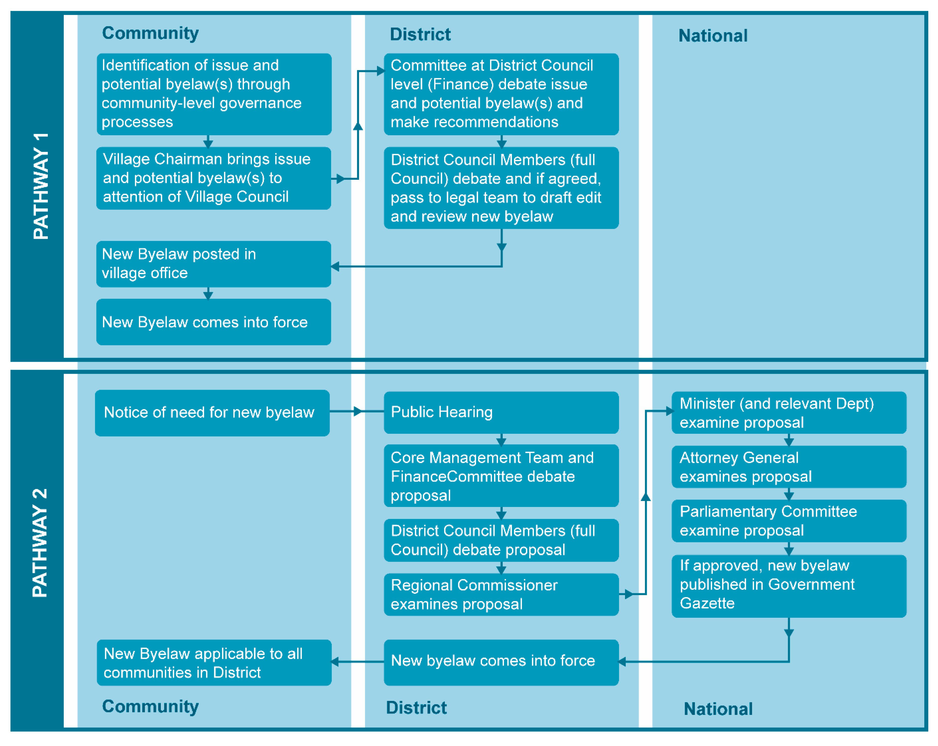
The Tanzanian Governance Context

The Tanzanian governance context provides a good example of how seemingly distant historic policy landscapes can still influence the way communities interact with their environments. Historical records suggest that prior to colonial occupation and, later, independence, indigenous cultures in East Africa were often spatially overlapping with dynamic and interacting spheres of influence [19]. Pre-colonial land use regulation in this geographical area demonstrated remarkable flexibility in adapting to new agricultural technologies, climate fluctuations, livelihood opportunities, population change and trading relations [20]. Resource and land use systems were based on deep knowledge of specific landscapes, and embedded in complex socio-cultural governance mechanisms. For example, agriculture and resource extraction activities were adapted to the requirements of specific ecosystems, and societies developed sophisticated ways to regulate resource use in these dynamic environments. These mechanisms were, however, subsequently displaced by Western-centric and top–down colonial natural resource management practices [21].
Colonial imperialism ended indigenous self-determination in East Africa by taking advantage of governance structures weakened by the impacts of slave raiding, disease and drought. Colonial rule subjugated native populations from the end of the nineteenth century, first as German East Africa, and from 1919 to 1967 as the British territory of Tanganyika [21]. Whilst the policy approaches of these colonial administrators differed, they were both instrumental in centralisation or abandonment of traditional local governance systems [22,23]. The key driver of these changes was a Western-centric ideology that separated and compartmentalised human–environment interactions into market-led agriculture and commercial resource management to the benefit of colonial interests [23,24,25,26]. During the latter part of the colonial era in Tanganyika, the British administration attempted to stimulate rural development through agricultural modernisation with a push towards enforcing adoption of Western agricultural ‘improvement’ practices. Byelaws were used to enforce top–down crop selection, reduce cattle numbers and establish disease controls such as livestock dipping. Little or no attention was paid to the on-the-ground realities of this ‘improvement’ [27].
Parallel to enforcement of Westernised land use policies was the almost total dismissal of local indigenous land and resource governance processes [28]. Eventually, grievances centred on British interference in land use and management formed one of the key drivers of the ‘nationalist’ movement, seeking self-determination and eventually leading to independence in 1961 [29,30]. Post-independence, the new Tanzanian administration chose to move away from colonial top–down ideologies of economic expansion and development based on agricultural modernisation. The new policy discourse focussed on development and equality; eradicating poverty and creating opportunities based on citizen participation, self-reliance and community action [31]. Colonial instruments to ‘force’ engagement, such as byelaws, were roundly rejected in favour of a culture of empowerment through education. Whilst the new ruling class rejected the exploitative nature of the colonial state, they retained a faith in the state as the driver of development [19,28]. At the outset, there was a desire to create a sense of self-direction and capacity to act within communities, and a belief in local-level innovation for sustained change. Ironically, however, although this new governance approach was focussed and built upon ‘grassroots’ participation, it did not engage with, or acknowledge, the long established traditional governance systems that had been marginalised or ignored by colonial systems and institutions for so long [31]. This fundamentally antagonistic relationship between informal indigenous and more rigid ‘new’ governance systems resurrected tensions that had remained along class and cultural fault lines. Eventually, and as a result of emerging tensions during the late 1960s and early 1970s, the socialist ideals of self-help lost traction as power shifted back towards centralised control, undermining the original self-help development drivers of community spirit and local pride.
The return to a top–down state-centric governance model culminated in the ‘Ujamaa Vijiji’ (villagisation) policy, through which new and formalised villages were ‘created’ across the spatial landscape, where people with very different cultural backgrounds and identities were often forced to move and, in the case of pastoralists, settle. This artificial creation of the ‘village’ as a nucleus for governance, development and policy implementation was one of the most severe spatial and socio-cultural disruptions of indigenous resource management and governance systems. Although based on deep knowledge and experience of specific landscapes, culturally embedded and well understood, these older informal systems were not always adhered to [32,33,34,35,36]. Moreover, these new and unfamiliar governance systems were sometimes unclear and led to power struggles. The role and power of Village Development Committees (VDCs), for example, were often undermined or severely curtailed by the perceived superiority of District Development Committees (DDCs) [6].
Systemic corruption and a lack of effective engagement in global-level processes eventually resulted in an economic collapse during the 1970s [34,37]. Under these deteriorating conditions, a ‘quiet revolution’ took place, replacing state-led centralism with localised governance systems [38]. Through this new liberalisation, major policy reforms in the 1990s which sought to reinvigorate the economy opened up new markets and agriculture to foreign investment [39,40,41]. The liberalisation of markets and land rights increased conflict between state policies and indigenous land management mechanisms, and by granting land traditionally used for extensive grazing to private sector agri-businesses continued the exclusion of pastoral communities [40,42,43]. Furthermore, the ongoing existence of both formal government leasing of land rights and informal indigenous land tenure systems continued to fuel land conflict, decreased land security and undermined incentives for long-term sustainable natural resource management [44,45]. The ongoing lack of recognition for indigenous land management systems and rights continues today and has further increased marginalisation of pastoralist communities [46,47]. Yet despite these historic lock ins and current challenges, liberalisation has also re-enabled a degree of self-determination within communities and provided new opportunities to reconnect them with regional-level governance processes [48].

2. Materials and Methods

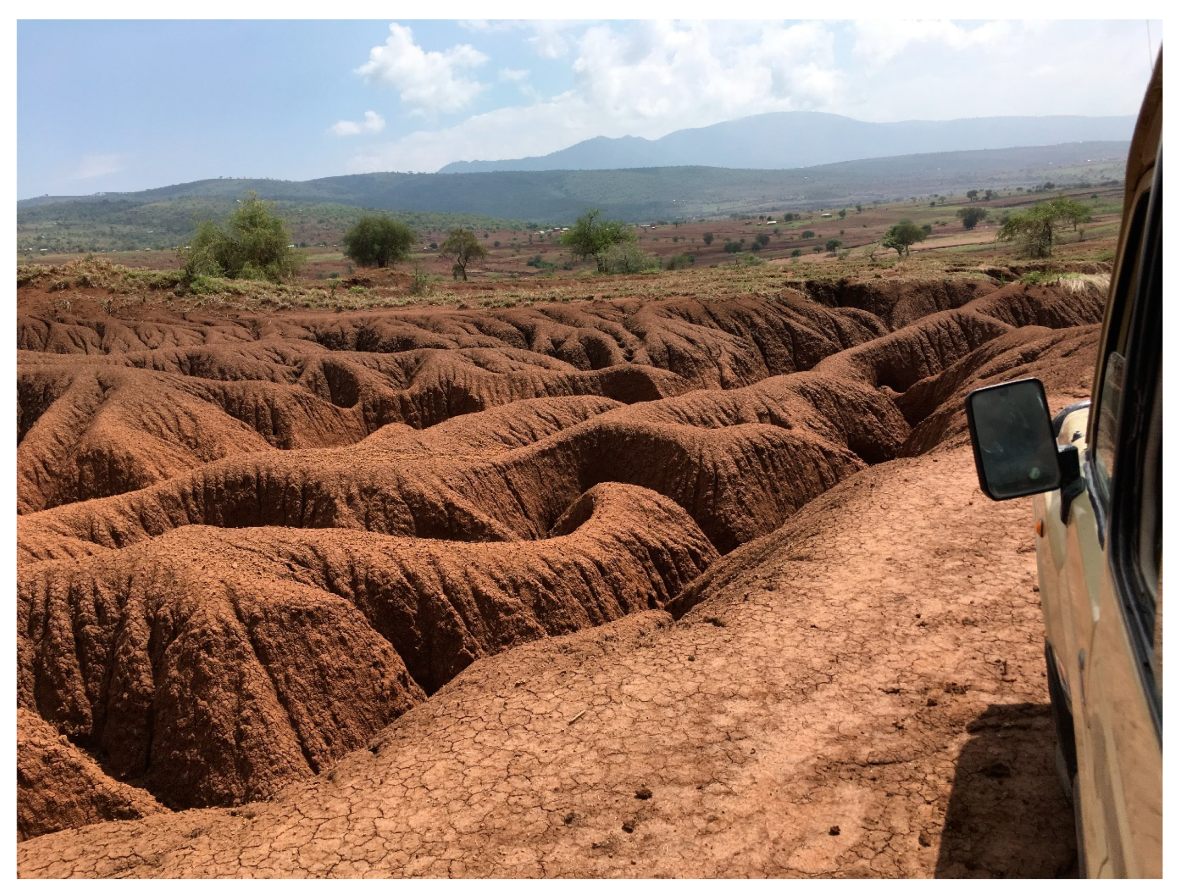
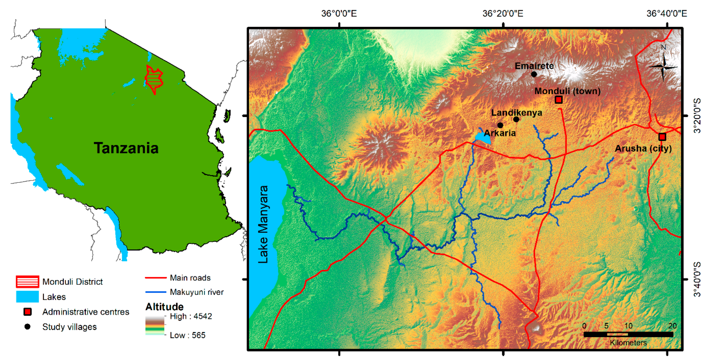
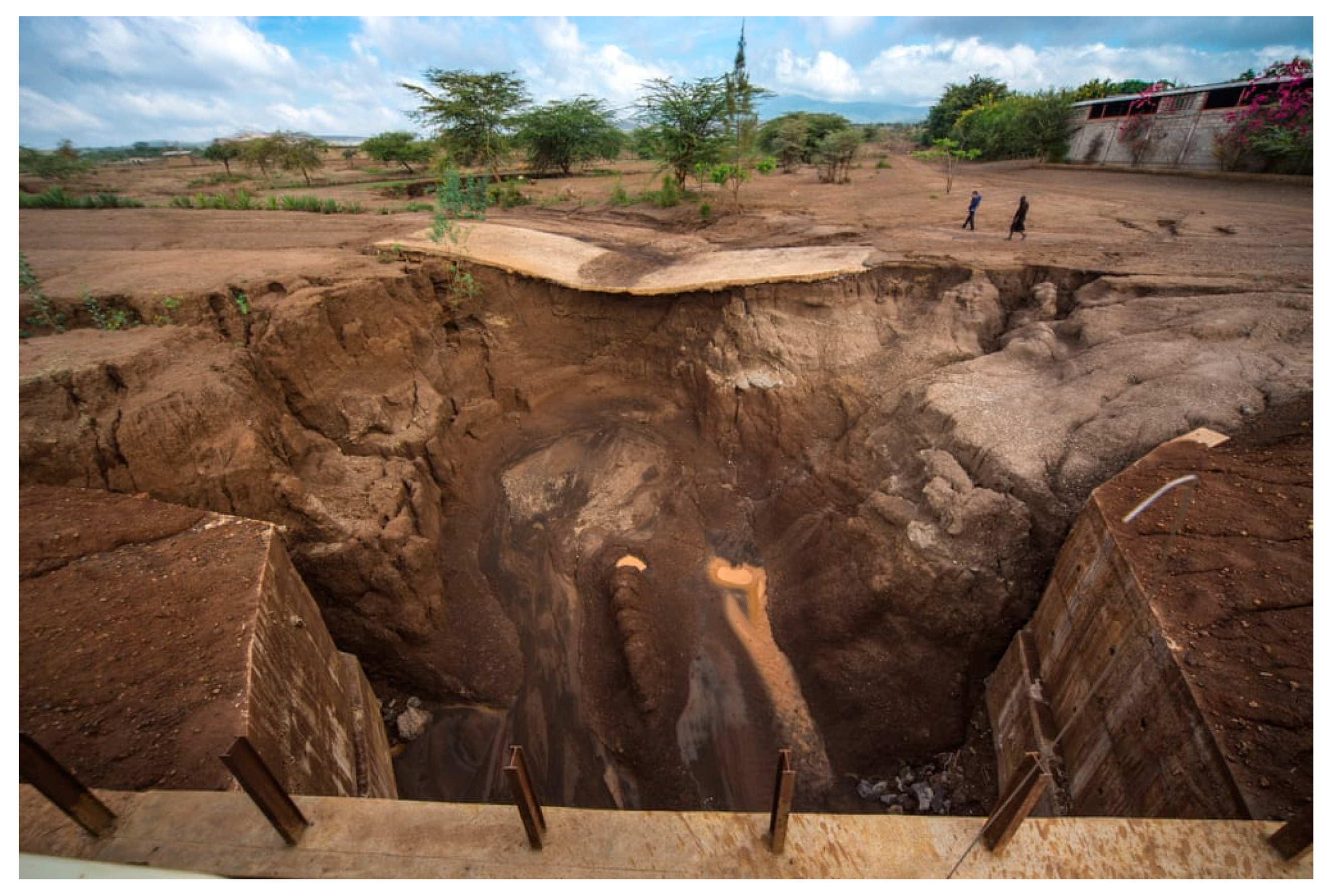
2.1. Case Study Context

The research reported here is part of a programme of sustained and ongoing engagement with three Maasai pastoralist communities (Figure 1) in Monduli, a district close to Arusha in northern Tanzania (for full case study justification and methodological details, see [13,16,18]). Participatory co-design work over a period of three years has gradually built trust and understanding between the communities and the UK and Tanzanian research teams. This pattern of ongoing engagement has been critical to establishing a deeper understanding of roles and responsibilities between participants, and in re-shaping power imbalances away from the original ‘researcher–subject’ duality of initial contact into more nuanced and equitable collaborative problem solving [49,50].
The three case study communities were selected, in collaboration with village leaders, to represent a range of climate, gradient and socio-cultural contexts [51]. One community is in the upland area (1814 m Emaerete) and the other two communities are in mid-elevation (1430 m Landikinya and Arkaria) areas. The geology is of volcanic origin and soils are characterised by highly weathered loamy clay andosols on the slopes, with swelling clay vertisols in the topographic swales. The mean annual rainfall ranges across a gradient from mid-elevation areas to upland areas [52]. The area has a typical bimodal wet season, with a short peak that occurs from November to December and a long peak between February and May; and one long dry season from June to October [53]. Local and global climatic phenomena such as the El Nino Southern Oscillation and the Indian Ocean Dipole interlink to create a high interannual variation wherein the short rains can fail (droughts) or connect to the long rains (wet) [54]. The natural vegetation is mostly an elevation-defined transition between savannah bushland and afro-montane rainforest. The landscape is characterized by severe surface denudation in open grazing land with notable rill and gully erosion by overland flow [16]. At all sites, sheetwash and associated soil erosion were causing notable loss of topsoil and incision of flow convergence pathways and drainage lines (Figure A1 and Figure A2, Appendix A) [13,18]. The population is expanding exponentially in this part of Tanzania, and figures are subject to change but, as an indication in 2012, Ward-level data shows that Monduli Juu (including Emaraete) had a total population of 15,914; and Sepeko (including Lendikinya and Arkaria) had a total population of 16,720 [55].
Local-level byelaws were one of the most often-cited requirements within a suite of institutional support needs identified by various stakeholder groups in previous research actions [13,16,18]. These needs fell into three broad categories:
  • Information (training in sustainable agriculture; terrace construction; contour farming; soil management; tree and shrub planting);
  • Policies (new byelaws; better monitoring and enforcement of existing byelaws; land use planning and zoning); and
  • Resources (Agricultural Extension Workers; locally appropriate tree species; better roads and trackways to avoid run off and erosion).
New byelaws were seen as a workable mechanism at the community level to:
  • Deal with existing erosion issues,
  • Develop sustainable land management strategies, and
  • Ensure legitimacy though existing governance processes.
There are currently two separate pathways through which new local legislation (byelaws) can be designed and enacted (Figure 2). Both processes are facilitated at the district level but there are key differences between them, depending on the nature of the issue to be addressed and the geographic applicability of the new byelaw. Pathway 1 is ‘bottom–up’ in that it is initiated at the community level. The process takes approximately three months to complete, is under the control of the district, with no need for state approval and results in a new byelaw that is applicable and enforceable only in the community in which it originated. Pathway 2 is ‘top–down’ in that it is initiated more generally at the district level, takes up to a year to complete and involves referral to state-level committees. This more complex pathway results in a byelaw that is applicable and enforceable district wide. Pathway 1 byelaws, established at the community level, that prove valuable and applicable to a wider geographic area (and or their clauses) can be formalised into laws/acts by parliament if they subsequently go through Pathway 2. In principle, then, Pathway 2 provides an avenue for byelaws developed at the community level to advance to national-level adoption and implementation if they prove particularly effective and/or reflect best practice.

2.2. Workshop Context and Follow-Up Interviews

The purpose of the workshop was to define and clarify the information, resource and policy needs identified in the earlier research actions noted above; and to explore whether locally designed and tailored byelaws (using Pathway 1, Figure 2) could provide potential policy solutions. All three case study communities were brought together for the workshop, which took place in a central and accessible location in Monduli District. A total of 57 participants attended the workshop, including agro-pastoralists from each of the three communities (48 in total); four officers from Monduli District Council (Land specialist, Economist and Agricultural Extension specialists); two non-governmental organisation (NGO) representatives and three ‘community champions’ from other communities in the locality. These ‘community champions’ had implemented sustainable production methods (agriculture, agro-pastoralism and/or fisheries) within their communities and were willing to share their knowledge and experiences with the case study communities.
The workshop (conducted in Swahili) was divided into three main working sessions, with soil erosion issues as the overarching theme (Table A1). Participants were grouped by community and each group also included a participant from Monduli District Council, together with a local ‘community champion’. Facilitation in each group was provided by a member of the Tanzanian research team, with an assistant. The three sessions were:(i) a community-specific session exploring existing information, policies, and resources; (ii) a community-specific reflexive session identifying actions to ‘stop’, ‘start’ and ‘keep’ in each community in order to address soil erosion challenges; and (iii) a sharing session (not community specific) in which individuals discussed and committed to actions they would take to tackle soil erosion over the short term (two weeks), medium term (two months), and long term (two years). Subsequent follow-up interviews were conducted (in Swahili) in each community to explore any successful actions and identify implementation problems.
As the local-level byelaw process is community specific, and the reasons for the lack of effectiveness of existing policies, laws and services were likely to be community specific, a plan was developed to enable communities to work together as a group first in order to keep a tight focus on identifying community-specific and tangible actions. The points emerging from these discussions could then be shared collectively in a feedback session to identify potential synergies and opportunities for intercommunity collaboration (Table A2). The workshop concluded with a sharing session, in which any individual or organisation could highlight actions that they wanted to take in the short, medium and long terms to address any aspects of the challenges discussed in the earlier sessions. This sharing session was voluntary, open to all and not community specific.
Previous Jali Ardhi project data sets were used during data analysis to provide contextual evidence of the governance background. This contextual data was integrated with new data from the byelaw workshop and subsequent follow-up interviews in the three communities (October 2019) in order to provide a deeper understanding of the impacts of policy mismatches and governance gaps on soil erosion challenges in the case study communities.

3. Results

3.1. Governance Challenges

Initial discussions during the workshop focussed on awareness of existing policies and the applicability and utility of those policies before moving on to identify community-specific policy needs. Tensions between different governance mechanisms, for example between cultural traditions around specific tree species, and district permit systems for tree cutting and forest clearance, were also revealed, as were perceived mismatches between actions and sanctions.
In terms of existing policies and policy instruments, there were differences between the three communities; some already had specific byelaws related to land management and resource conservation in place, whilst others did not. For those communities that did have byelaws, these were not necessarily related to soil erosion issues, and they were not consistently applied, enforced or effective. For example, although fines were applied to those breaking local byelaws aimed at limiting herd sizes (generally 30,000 Tanzanian Shilling or approximately £10 GBP), little action was taken until environmental conditions had a direct impact, as this community member notes:
EM1: ‘[…] And even livestock keeping has reduced to a big extend so far this is because during summer they get hard time getting grass for the animals. […] Even the laws have forced them to reduce the numbers of livestock but they still ignored but since they are facing drought and no enough areas of grazing they have decided to reduce the number of live stocks by themselves.’
In other communities, compliance with any existing agreements or byelaws depended on whether the transgression was likely to be seen or not, suggesting that although social norms around compliance existed, they were tempered by practical day to day pressures, as these examples highlight:
AK1: ‘Honestly, the big thing is terracing, but the main challenge is livestock crossing over terraces where by people would tend to watch if you are present or not and if you are present they won’t allow the herd to cross over otherwise If you are absent then destruction takes place.’
Interviewer:‘Do people challenge the laws made about environment?’
AK3: ‘Not all, people are now following laws its only drought that is the problem. If there are rains then everyone will follow.’
Enforcement of existing byelaws also revealed tensions and gaps between traditional and formal governance mechanisms. Traditional laws exist and are implemented, often with stricter enforcement or sanctions compared to formal byelaws. These traditional laws are monitored and enforced by the elder/leader of the group (Laigwanan). Discussions included how fines should be paid (in cash or in livestock), the need for translation of formal policies and laws from Swahili into Maasai, and tensions centred on how permits for cutting wood were assessed and administered. For example, one community highlighted a potential conflict of interest and tension between spatial levels and governance systems over effective monitoring and management of forest resources. The issue centred on the income generated from issuing permits for tree cutting in the community. This community did not have an existing land management plan, and no formal assessment of resources (including traditionally important tree species, which in the past were protected) had been completed before permits were issued, as this statement from a rapporteur during the workshop highlights:
Rapporteur 1:‘And in the past, the law was allowing people to take wood for cooking but not cutting trees. And it’s funny that people in the District […] they normally give permits for people to cut trees and in this District, they don’t know how many trees are there. Yeah, so they are allowing people to cut things which are not there, because they want the income. And also they allow them to cut trees and burn charcoal, and prepare charcoal for sale. And there is some traditional trees that were not supposed to be [cut], and there’s no any byelaw that is directing the proper land use plan.’
Many similarities emerged between communities in terms of activities deemed to be damaging either to the environment or to communities’ ability to sustainably manage resources. Several individuals highlighted the need for byelaws to address specific practices such as grazing cattle in the forest, and forest cutting and clearing, although it was recognised that these actions often occurred due to the interaction of these pressures with extreme or prolonged drought, which did not necessarily occur every year. Key areas for new byelaws were identified including:
  • To prevent forest and scrub clearance. Policy instruments were requested to control felling of trees and cutting branches for firewood and other uses.
  • To ensure conservation farming measures were implemented in upland areas, including contour ploughing, terrace construction and maintenance, and water run-off management in upland and upslope areas, to prevent erosion further downslope.
  • To prevent existing trackways becoming new gullies.
  • To create and better manage livestock grazing zones to prevent uncontrolled and overuse of key areas prone to erosion and enable vegetation recovery and land cover during drought.
As noted above, more collaborative planning of access rights to water resources was also needed, particularly for cattle drinking areas, access to which was shared with other nearby communities, or where traditional reciprocal rights and arrangements to water existed but were not being managed. For example, the trackways used to move cattle around the community and between grazing areas were specifically mentioned. These trackways have been identified by previous work within these communities as one of the key drivers of soil erosion and gullying in this area (see [13,16,18]). These trackways are heavily used by both cattle and people (including motorbikes and vehicles) and eventually become key channels for water run off and incision. New byelaws were therefore identified as a need in order to encourage better management and maintenance of the trackways, using locally available materials to create more durable surfaces. Many participants also highlighted the need for much more support to enable formal land use plans to be drawn up for each community, including identifying sensitive areas where grazing needed better control. Follow-up interviews with community members revealed some progress in developing new byelaws to address these issues but in most cases, action had stalled in 2019 due to drought, which had shifted the priority to securing water. Further follow-up interviews with communities and the District Council are scheduled for October 2020.

3.2. Practical Challenges

The majority of participants were clear on their recognition of the soil erosion problem and their strong desire to take action (see Table A1). Several attempts were made to remediate gully formation by back filling with manure, branches and other materials which were locally available but these efforts had not been successful. Follow-up interviews revealed that participants had made good on their commitments to plant trees, but this had not been successful because of a lack of knowledge on tree aftercare, a lack of water availability and management, and livestock grazing off the new growth, as these interviewees highlighted:
EM1:‘Yes, tree seedlings were planted but we faced a few challenges as the rains were not forthcoming at the time. We organised with the people from the tree nursery and they transported the same to us and people got involved in planting but at the time the rainfall levels were diminishing and thus some dried out from the scorching sun. Those who planted earlier in other areas were successful.’
AK1:‘The first was drought, but the other challenge was livestock such as goats which are troublesome because in the Maasai tribe there are big and small goats (mbalelo). The older goats are taken away from home to search for pasture but the younger ones remain at home. So, the growing ones eat leaves and also eat up planted trees. Therefore, preventing the young goats from being destructive is hard.’
Participants called, therefore, for context-specific support and training, such as on-site demonstration, to identify and implement rehabilitation plans for these areas (Table A1). Expert advice was also requested to identify locally appropriate tree species for reforestation that were disease and drought tolerant, and were not so palatable to livestock. Several participants identified potential sources for trees, alongside suggestions for appropriate local organisations to manage distribution and planting in order to ensure effective planting and ongoing maintenance. Similarly, a need for information and training on water management on farms to control erosion and provide water for newly planted trees was highlighted, with demonstration plots and visits to local farms using best practice in integrated water management seen as the best way to encourage uptake of these measures within communities. A lack of education, and a culturally-based lack of willingness to engage in learning without being able to see demonstrations of positive change was also highlighted by some communities as a barrier, but also a mechanism for success, as these two statements highlight:
Rapporteur 2:‘So they are saying, of what they know, the Maasai people, they state it is very difficult for them to accept new things. They say they will believe it if they see it happen [with their own eyes], they say that if they come there and they need to be told and be given the information and later the mobilisation to ensure that the land degradation issues are addressed. So they want to see it, yeah.’
EM3:‘What has changed is people now want to learn more about environmental conservation. Many people right now are copying from those who have conserved the environment. For example, when many pass by my house and see me planting trees they are always curious to know how I’ve done to improve my environment. So, I begin to teaching them how to grow trees and look after the environment. People also dig wells to store water and also to harvest rainwater.’
Regular movement of livestock on unsurfaced trackways was raised by all three communities as a problem practice that needed to be addressed. Surfacing with locally available stone was suggested as a potential solution, allied to better control of stock movements from other communities, through traditional reciprocal grazing and cattle drinking arrangements, which were uncoordinated and unregulated. Solutions included a request for support from the District Council to enable the provision of livestock drinking places in each community which would reduce the need for extensive herd movements between villages, and grazing policies to prevent haphazard and unregulated grazing on communal lands.

3.3. Wider Issues

Participants identified wider issues such as education and development needs; family planning; challenging cultural and social norms, including gender roles; and the impacts of climate change. In dealing with these challenges, however, participants highlighted some of the socio-cultural changes that they wanted to make, including changing negative environmental behaviours, and encouraging better acceptance of the need for education and knowledge sharing, alongside better compliance with existing regulations including byelaws and other conservation legislation. Several participants also highlighted the need to develop capacity within communities for innovation and to draw on internally-held resources to become less dependent on external support in the future. Where externally provided training and support to build capacity were available, they were not always deemed effective for the following reasons (Table A2):
  • Distance. The villages nearest to tarmac roads were often the ones approached first to participate in research, support or training, whilst those further from good roads were less likely to be chosen, leading to a sense of being forgotten, and slower in terms of development.
  • Purpose. Many initiatives included multiple objectives which were not always integrated—for example, child care and environmental conservation. Villagers were unclear on what actions they should focus on, resulting in failure across all actions.
  • Follow up. Where initiatives were brought to the village, they were often not effectively followed up, hence failing to achieve any medium- or long-term objectives. Allied to this was a lack of feedback to the community, with no information on whether the project as a whole had failed or what lessons the community could learn from the outcomes.
The lack of training and support orientated to women farmers were also raised as a particular need, along with more easily accessible opportunities within each community so that all community members (not just some) could attend training events. Alongside this, need for better understanding of, and support for, family planning and gender-based rights and issues were also raised, although the discussion on this during the workshop was limited and it was clearly a very sensitive topic. Follow-up interviews did, however, show that socio-cultural changes had been gaining traction:
Interviewer:‘What are the things that people still do from the past? The things that are yet to change? Like people do them as their routine?’
[…]
EM1:‘A lot are yet done. But for now, people have changed. For instance, in the past small girls were married but now people educate their children mostly the girls because they have known that girl children are more helpful if educated. This was something that was very difficult for a Maasai to do.’
Interviewer: ‘Do they involve women in meetings?’
EM1: ‘Yes they do, but in the past women themselves where the ones keeping themselves out. But right now they are aware that they can do a lot of things and right now when you go in the markets women are the ones that do business. But before they used to go graze the animals with the children. Most women right now have involved themselves in smalls groups of loans that they get money to buy basic needs and even building houses by themselves.’
Interviewer:‘Is there anything that has changed so much that you think was not there before?’
EM1:‘In general, during the past people never bothered building houses even if they had a lot of livestock, and even farming was not in Maasai culture. They only thought that having a lot of livestock was enough and there was no need of getting a farm to farm, or educating the children or doing any other business. But right now, they keep animals, they farm, they educate and also build nice houses. So, a lot has changed now.’
Barriers and challenges in changing day to day actions and shifting livelihoods onto more sustainable pathways provide clear indications of the impact of wider-than-focal-issue constraints on implementing potential solutions. These insights also highlight the complex and dependent connectivity that exists between socio-cultural, institutional, economic and environmental processes operating at different speeds and across variable spatial levels, and which have a clear impact on the ability of communities to build resilience to soil erosion challenges.

4. Discussion

4.1. Fragmented Governance Approaches

Tanzania has one of the most advanced legal and policy frameworks in Africa to enable the management and ownership of natural resources by rural communities. Since the late 1990s, responsibility for natural resource management has been gradually transferred from central government to local communities [56]. This shift, starting in 1998, pushed for the first time for a change in the way wildlife and forests were managed (e.g., Wildlife Policy and the National Forestry Policy). It was followed in 2002 by the Forest Act and in 2004 by the Wildlife Act, which allowed communities a much more significant stake in managing (or co-managing) forests and wildlife [57,58,59].
As noted in the introduction, this state-led governance context overlays much older cultural and ethnically-rooted governance systems, which were alluded to by several workshop participants. Despite management devolution efforts for some natural resources, state-led institutions and policies are still conceptualised and disseminated within a formal institutional and spatial framework (state; region; district; division; ward; village) which, at this local level in particular, is sometimes at odds with the ways that other, linked environmental resources, (access to water and grazing for livestock, for example) are managed day to day. In this example, top–down governance often lacks the spatial and temporal nuances needed to manage dynamic and complex East-African rangelands with their historic socio-cultural systems [17]. Modern policy instruments tend to use a broad brush unlike older governance systems, which are more tightly coupled with local environmental conditions, enabling adaptable, flexible and reciprocal responses to seasonal and longer-term changes, although even these are not always enforced [16,60]. In this context, the workshop data has shown that implementation of socially acceptable and environmentally desirable state-defined solutions is often limited by (i) fundamental gaps between knowledge bases at different spatial levels, and missing information on the local situation; and (ii) an implementation gap between science-based recommendations, policies and temporal dynamics (such as droughts) on the ground [56,59].
Conversely, the workshop data also shows that customary and informal governance systems that have co-evolved with local environmental dynamics are potentially enforceable, through identity-based loyalties. However, historic dismissal of customary systems in combination with increasing heterogeneity of Tanzanian communities have undermined their efficacy. As Figure 2 has highlighted, however, Tanzania’s governance system allows for the need for, and design of, hybrid context-specific byelaws to be designed and implemented through a local-district-level process, without recourse to national-level decision making. Although these byelaws are only applicable at the local/district level, they, nonetheless, provide a relatively rapid way for natural resource management issues, such as the soil erosion challenges seen in our communities, to be addressed. In addition, the appetite for hybrid policy development shown by our study communities highlights the possibility that if new byelaws prove effective in supporting positive change, there could be an opportunity for advancement to Pathway 2 but this would need to be initiated from the district level. This option was not explored by our study but it is something that we are considering investigating for future work, and we hope to continue to track and support progress in this respect.

4.2. Closing the Governance Gap

More information is needed to enable the longer-term applicability of hybrid and integrated governance approaches to emerge. Several studies have attempted to understand the impacts of different governance models on nationally designated protected areas, such as forests (c.f. [57,61,62,63,64]). For instance, Blomley et al. [56] found that forests under participatory forest management regimes showed positive signs of improvement in forest condition. These initial findings, however, need to be assessed over much longer timescales and using multiple environmental and socio-economic variables in order to clearly show their benefits for soil erosion mitigation and other land management challenges.
The Jali Ardhi participatory research has started to address these wider contextual issues in that the workshop revealed the existence of a mismatch between community-based participatory policy making and centrally-coordinated governance systems. Follow-on interviews have highlighted small steps forward, alongside ongoing shifts in deeper socio-cultural norms within the communities. The reasons for the mismatch or governance ‘gap’ have emerged through a process of state-level evolution, as Tanzania has shifted through different phases of nation making. Whilst both bottom–up (co-stewardship of community resources) and top–down (centrally-managed strategic conservation and socio-economic development objectives) are important, especially in sustaining natural resources at the landscape level, combining them can create a formidable approach that is context responsive and can provide long-term solutions to support sustainable resource use. Based on the data emerging from the workshops, and alongside current best practice in equitable and sustainable land management, there is a significant opportunity to build institutional capacity and coordinate strategic agendas across spatial levels to enable better decision making, support development trajectories and make significant progress in implementing key Sustainable Development Goals (SDGs) across Tanzania.
Moreover, the integration of local informal systems into formal and centralised governance structures diminishes the confusion/mismatch and conflicts that still exist between both systems. Formalised byelaws provide legal back up if challenged, potentially leading to better levels of trust in the governance of natural resources. These findings are not just related to soil erosion challenges but relevant across sustainable development objectives and can build resilience to future challenges by supporting the emergence of a new culture of innovation from within communities, not imposed from outside. In that context, it is important that byelaws and policies are focussed on specific local resource management issues to achieve better long-term environmental and social sustainability.
This study highlights the potential of the byelaw system to bridge the gap between dynamic local resource management needs and wider regional and national policy ambitions, including the need for effective monitoring and enforcement. The byelaw system provides a framework to formalise previously customary rules and integrate them into the Tanzanian legal system. Locally designed byelaws are better suited for the specific socio-ecological context and, at the same time, are no longer dependent on identity-based loyalties; participants were clear that these new governance approaches had the potential to work for everyone within the community, regardless of their cultural background [38].

5. Conclusions

Despite the challenges, solid progress has been made in starting to develop locally tailored policy and practical solutions by paying attention to the seemingly peripheral issues of governance ‘mismatches’ and wider-than-focal-issue drivers and impacts. This work shows that by understanding the context-specific role of local governance processes, and joining those process together with clear and realistic locally designed actions, collective energy for change can result, thereby strengthening community- and, potentially, regional-level resilience to complex and seemingly intractable soil erosion challenges.
This study focussed on the challenges originating from implementation of conservation and land management policies and practices based on information and models generated elsewhere and in the past. The researchers worked with three pastoralist communities in northern Tanzania to understand the basis for formulating and implementing the rules and regulations that govern natural resource use at the local level. It is anticipated that the information and experiences gained can be used to inform and contribute to the adoption of co-management approaches elsewhere in order to support integration of externally-derived knowledge with a context-relevant community/stakeholder-driven approach.
Governance styles in natural resources management in Tanzania have undergone significant shifts across the twentieth and into the twenty-first century, from pre-colonial environmental system based, through rigid and formalised colonial rule, and on through post-independence centralised and semi-centralisation to current hybrids. These hybrids, with their bottom–up focus on local environmental knowledge, have a more socio-culturally driven basis to resource management compared to state-led strategically informed systems which are more socio-economic and development driven. Both systems have well-documented negative aspects but recognising and creating mutually beneficial connections between these systems can offer significant opportunities to create more robust, locally appropriate and better understood policy actions which can result in sustainable, and sustained livelihood change [16,60,65].
Soil erosion is a multi-scalar challenge, driven by complex and sometimes hidden processes, and is deeply impacted by past institutional and governance contexts. Our research has also shown that action for change to enable sustainable responses to soil erosion challenges can be achieved by making governance processes locally understandable, and creating space for actors from multiple spatial levels to connect and engage with each other more effectively. In this context, byelaws can offer a starting point for integrating local resource management systems into formal government policy structures, leading to effective, sustained and positive change. Ultimately, this can lead to sustainable livelihoods and the achievement of long-held development ambitions, including the eradication of poverty, equitable gender roles and education for all.

Author Contributions

Conceptualisation, C.K., M.N., A.P., L.K.M., K.M.M, W.B., P.A.N., G.W., M.W., A.R., D.G. and F.M.; methodology, C.K., M.N. and A.P.; formal analysis, C.K., A.P. and M.N.; investigation, C.K., M.N., A.P., L.K.M., K.M.M., F.M., W.B., and P.A.N.; writing—original draft preparation, C.K. and M.W.; writing—review and editing, L.K.M., K.M.M., and M.N. All authors have read and agreed to the published version of the manuscript.

Funding

This research was funded by UK Research and Innovation Global Challenges Research Fund (GCRF), grant number NE/P015603/1 and UK Natural Environment Research Council (NERC), grant number NE/R009309/1. The APC was funded by the University of Plymouth.

Acknowledgments

The research team is indebted to all of the local community leaders, community members, facilitators, ‘champions’, NGO and support organisation staff and Monduli District Council, for their participation, enthusiasm and committed engagement with the research programme. Furthermore, the authors would like to thank Tim Absalom and Jamie Quinn from the GeoMapping unit of the University of Plymouth for their assistance in designing the figures.

Conflicts of Interest

The authors declare no conflict of interest. The funders had no role in the design of the study; in the collection, analyses, or interpretation of data; in the writing of the manuscript, or in the decision to publish the results.

Appendix A

Figure A1. Severe gullying, Monduli District, Tanzania. Source: Authors.
Land 09 00352 g0a1
Figure A2. Impacts of soil erosion processes on community infrastructure. Source: Carey Marks/University of Plymouth.
Land 09 00352 g0a2
Table A1. Byelaw workshop structure.
TimeActionFormatDetails
9 am–9:30 amArrival
Tea/Coffee
All togetherGuide participants to tables (Note: every village has its own designated table)
9:30 am–10 amWelcome/Brief introduction to project and teamAll together
  • Jali Ardhi project; past and present
  • The purpose of today’s workshop
  • The day’s schedule
  • Introduction to the first exercise
10 am–12 pmActivity 1: What do we have; information, resources, policies?Village-specific round table discussion—1 table for each villageFacilitators recount discussion summary from each community back to allEach table consists of:
  • 10–15 participants from the same village
  • A District Council rep
  • A champion
  • A facilitator
  • A facilitation assistant
12 pm–1 pmLunch
1 pm–2:30 pmActivity 2:
What do we need; start-stop-keep?
Village-specific round table discussion—1 table for each village
Facilitators recount discussion summary from each community back to all
This exercise is a combination of group discussion and individual work

Following the morning discussion, the facilitators and champions encourage participants to note down what (information, resources, and policies) they would keep, what existing things they think need to stop and what new actions they think should start

During lunch break, facilitator assistants will help team to capture the emerging themes from the morning discussions to keep the afternoon exercise focused on actual specifics
2:30 pm–3 pmSharing ideas and committing to actionAll togetherFeedback and discussion led by facilitators;
individuals are invited to share actions they will take in the next two weeks, two months, and two years
3 pm–4 pmGifts
Tea/Coffee
All togetherThanks, future plans and goodbye
Table A2. Examples of information, resource, training and policy issues, as identified by communities.
INFORMATION AND RESOURCES
Information needs
  • Most information provided by trainers into our village is a general information; therefore, we suggest that information to be provided based on where people come from (specific location). Those dwelling on uplands will tend to have slightly different practices compared those in lowlands.
  • Using pastors and church leaders to inform and encourage people on environment conservation because people trust such leaders.
  • Involve and train women on environment conservation because women are the most practitioners group in most plans
  • Follow up of those who attend trainings

Resource needs
  • Need for experts from agriculture, land use planning, and legal authority
  • Availability of trees for planting is limited. Tree nurseries should be established and also provide people with education on how to plant trees
  • Water is a huge challenge and therefore digging wells can help the availability of water
  • Experts on land use planning should visit the village and educate people rather than selecting few people and educating them outside the village.
TRAINING
Available training
  • There have been trainings on land conservation but not regularly. For example, at district level there has been a few people from the village involved six years ago.
  • Training from World Vision
  • Training on child care and environment conservation from HIMS
  • Training on agricultural practices from Selian agricultural research institute

Has training been effective?Most trainings into the village haven’t been effective due to the following reasons:
  • Distance. Villages near by good roads (tarmac) get favoured with various projects/trainings while those far from good roads remain forgotten hence leading to slow development
  • Projects brought into the village aren’t effectively followed up hence failing to achieve what was intended
  • Lack of feedback to the community. No information on whether project failed or what went wrong for its failure
  • Multiple objectives rather than single objective. For example, child care and environmental conservation. Villagers fail to catchup on what they can actually focus at resulting into a failure

Things needed to implement the techniques learned;
  • Education to the community because of low understanding. For example, out of ten people only two know how to plant trees
  • Various techniques of environment conservation
  • Practical support in conserving the environment rather than just theoretical
  • Environment conservation and improvement committee
POLICY
Existing land management policies
  • There are no laws that guide the village on land uses
  • The village has no wide understanding of the national and international policies
  • There are no any translated policies and made available in village offices. Also, if available the policies are not translated in simple language that can be understood by everyone
  • There are no policies that control family growth
  • Permits for cutting down trees are issued at district levels and therefore it’s an income source hence environment destruction takes place because there is no enough information about the environment situation in each village. It’s advised the permits be issued at village level

Suggested byelaws
  • Each family to plant five trees otherwise a fine of Tsh 30,000 should be charged to those who violate
  • Old trees such as Oreteti shouldn’t be cut down
  • Byelaw that protects catchment areas and stop livestock from entering the catchment areas. No one should be allowed to go beyond 70m close to the catchment area
  • Byelaw that all farmers on the uphill to obtain advice from agricultural experts before farming season starts so that they can learn how poor farming on the uphill triggers soil erosion on the slopes
  • Byelaw that prevents animals from moving anywhere but rather setting special areas where livestock can graze. Grazing on prohibited areas can lead to Tsh 30,000 fine

Are these byelaws implementable?
  • Yes. When the byelaws are enacted, those who attended trainings should be a good example to who haven’t attended the training
  • We will stop people from cutting down trees we have planted
  • We will make sure every member of the community is aware of the byelaws on land management
Source: Bylaw community workshop, Monduli, December 2018.

References

  1. Blaikie, P. Land Degradation and Society; Blaikie, P., Brookfield, H., Eds.; Methuen: London, UK, 1987; p. 296. [Google Scholar]
  2. Wilson, G.A.; Juntti, M. (Eds.) Unravelling Desertification: Policies and Actor Networks in Southern Europe; Wageningen Academic Publishers: Wageningen, The Netherlands, 2005; p. 246. [Google Scholar]
  3. Brockington, D. Fortress Conservation: The Preservation of the Mkomazi Game Reserve, Tanzania; Indiana University Press: Bloomington, IN, USA, 2002. [Google Scholar]
  4. Briassoulis, H. Governing Desertification in Mediterranean Europe: The challenge of Environmental Policy Integration in Multi-Level Governance Contexts. Land Degrad. Dev. 2011, 22, 313–325. [Google Scholar] [CrossRef]
  5. Kelly, C.; Ferrara, A.; Wilson, G.A.; Ripullone, F.; Nolè, A.; Harmer, N.; Salvati, L. Community Resilience and Land Degradation in Forest and Shrubland Socio-Ecological Systems: Evidence from Gorgoglione, Basilicata, Italy. Land Use Policy 2015, 46, 11–20. [Google Scholar] [CrossRef] [Green Version]
  6. Pretty, J. Participatory Learning for Sustainable Agriculture. World Dev. 1995, 23, 1247–1263. [Google Scholar] [CrossRef]
  7. Pretty, J.N. Agri-Culture: Reconnecting People, Land and Nature; Earthscan: London, UK, 2002. [Google Scholar]
  8. Díaz, S.; Demissew, S.; Carabias, J.; Joly, C.; Lonsdale, M.; Ash, N.; Larigauderie, A.; Adhikari, J.R.; Arico, S.; Báldi, A.; et al. The IPBES Conceptual Framework—Connecting Nature and People. Curr. Opin. Environ. Sustain. 2015, 14, 1–16. [Google Scholar] [CrossRef] [Green Version]
  9. FAO. Status of the World’s Soil Resources: Main Report; Food and Agriculture Organisation of the United Nations, ITPS, Global Soil Partnership: Rome, Italy, 2015. [Google Scholar]
  10. Borrelli, P.; Robinson, D.A.; Fleischer, L.R.; Lugato, E.; Ballabio, C.; Alewell, C.; Meusburger, K.; Modugno, S.; Schütt, B.; Ferro, V.; et al. An assessment of the global impact of 21st century land use change on soil erosion. Nat. Commun. 2017, 8, 2013. [Google Scholar] [CrossRef] [PubMed] [Green Version]
  11. Blaikie, P. Changing environments or changing views? A political ecology for developing countries. Geography 1995, 80, 203–214. [Google Scholar]
  12. Smit, H.; Muche, R.; Ahlers, R.; Zaag, P. The Political Morphology of Drainage—How Gully Formation Links to State Formation in the Choke Mountains of Ethiopia. World Dev. 2017, 98, 231–244. [Google Scholar] [CrossRef]
  13. Blake, W.H.; Rabinovich, A.; Wynants, M.; Ndakidemi, P. Soil erosion in East Africa: An interdisciplinary approach to realising pastoral land management change. Environ. Res. Lett. 2018, 13, 124014. [Google Scholar] [CrossRef] [Green Version]
  14. Mazzocchi, F. Western science and traditional knowledge. Despite their variations, different forms of knowledge can learn from each other. EMBO Rep. 2006, 7, 463–466. [Google Scholar] [CrossRef] [Green Version]
  15. Wilson, G.A.; Kelly, C.L.; Briassoulis, H.; Ferrara, A.; Quaranta, G.; Salvia, R.; Detsis, V.; Curfs, M.; Cerda, A.; El-Aich, A.; et al. Social Memory and the Resilience of Communities Affected by Land Degradation. Land Degrad. Dev. 2017, 28, 383–400. [Google Scholar] [CrossRef]
  16. Wynants, M.; Kelly, C.; Mtei, K.; Munishi, L.; Patrick, A.; Rabinovich, A.; Nasseri, M.; Gilvear, D.; Roberts, N.; Boeckx, P. Drivers of increased soil erosion in East Africa’s agro-pastoral systems: Changing interactions between the social, economic and natural domains. Reg. Environ. Change 2019, 19, 1–13. [Google Scholar]
  17. Habtezion, S.; Adelekan, I.; Aiyede, E.; Biermann, F.; Fubara, M.; Gordon, C.; Gyekye, K.; Kasimbazi, E.; Kibugi, R.; Lawson, E.; et al. Earth System Governance in Africa: Knowledge and capacity needs. Curr. Opin. Environ. Sustain. 2015, 14, 198–205. [Google Scholar] [CrossRef]
  18. Rabinovich, A.; Kelly, C.; Wilson, G.; Nasseri, M.; Ngondya, I.; Patrick, A.; Blake, W.H.; Mtei, K.; Munishi, K.; Munishi, L.; et al. “We will change whether we want it or not”: Soil erosion in Maasai land as a social dilemma and a challenge to community resilience. J. Environ. Psychol. 2019, 66, 101365. [Google Scholar] [CrossRef]
  19. Mamdani, M. Citizen and subject: Contemporary Africa and the Legacy of Late Colonialism; Princeton University Press: Princeton, NJ, USA, 2018. [Google Scholar]
  20. Snyder, K.A. Agrarian change and land-use strategies among Iraqw farmers in northern Tanzania. Hum. Ecol. 1996, 24, 315–340. [Google Scholar] [CrossRef]
  21. Diaw, M.C. Social and Production Relationships in the Artisanal Maritime Fisheries of West Afrcia: A Comparative Analysis; Michigan State University: Lansing, MI, USA, 1983. [Google Scholar]
  22. Kjekshus, H. Ecology Control & Economic Development in East African History: The Case of Tanganyika 1850–1950; Ohio University Press: Athens, OH, USA, 1996. [Google Scholar]
  23. Anderson, D. Depression, dust bowl, demography, and drought: The colonial state and soil conservation in East Africa during the 1930s. Afr. Aff. 1984, 83, 321–343. [Google Scholar] [CrossRef]
  24. Smith, C.D. Did Colonialism Capture the Peasantry: A Case Study of the Kagera District, Tanzania; Nordic Africa Institute: Uppsala, Sweden, 1989. [Google Scholar]
  25. Huijzendveld, F.D. Changes in political economy and ecology in West-Usambara, Tanzania: Ca. 1850–1950. Int. J. Afr. Hist. Stud. 2008, 41, 383–409. [Google Scholar]
  26. Monson, J. Relocating Maji Maji: The politics of alliance and authority in the southern highlands of Tanzania, 1870–1918. J. Afr. Hist. 1998, 39, 95–120. [Google Scholar] [CrossRef]
  27. Lovett, J.; Quinn, C.; Kiwasila, H.; Stevenson, S.; Pallangyo, N.; Muganga, C. Overview of Common Pool Resource Management in Semi-Arid Tanzania; Centre for Ecology, Law and Policy, University of York: Heslington, UK, 2001. [Google Scholar]
  28. Burton, A.; Jennings, M. Introduction: The emperor’s new clothes? Continuities in governance in late colonial and early postcolonial East Africa. Int. J. Afr. Hist. Stud. 2007, 40, 1–25. [Google Scholar]
  29. Mung’ong’o, C.; Loiske, V. Structural Adjustment Programmes and Peasant Responses in Tanzania; Pluto Press: London, UK, 1995. [Google Scholar]
  30. Cliffe, L.R. Nationalism and the reaction to enforced agricultural change in Tanzania during the Colonial period. Taamuli 1970, 1, 3–15. [Google Scholar]
  31. Jennings, M. A Very Real War: Popular Participation in Development in Tanzania During the 1950s & 1960s. Int. J. Afr. Hist. Stud. 2007, 40, 71–95. [Google Scholar]
  32. Kjekshus, H. The Tanzanian villagization policy: Implementational lessons and ecological dimensions. Can. J. Afr. Stud. Rev. Can. Des Études Afr. 1977, 11, 269–282. [Google Scholar]
  33. Boesen, J. Tanzania-From Ujamaa to Villagization; Institute for Development Research: Bochum, Germany, 1976. [Google Scholar]
  34. Hydén, G. Beyond Ujamaa in Tanzania: Underdevelopment and an Uncaptured Peasantry; University of California Press: Berkeley, VA, USA, 1980. [Google Scholar]
  35. Lawi, Y.Q. Tanzania’s Operation Vijiji and Local Ecological Consciousness: The Case of Eastern Iraqwland, 1974–1976. J. Afr. Hist. 2007, 48, 69–93. [Google Scholar] [CrossRef]
  36. Kikula, I.S. Policy Implications on Environment: The Case of Villagisation in Tanzania; Nordic Africa Institute: Uppsala, Sweden, 1997. [Google Scholar]
  37. Coulson, A. Agricultural Policies in Mainland Tanzania, 1946–1976. In Rural Development in Tropical Africa; Springer: Berlin/Heidelberg, Germany, 1981; pp. 52–89. [Google Scholar]
  38. Heald, S. State, law, and vigilantism in northern Tanzania. Afr. Aff. 2005, 105, 265–283. [Google Scholar] [CrossRef]
  39. Coldham, S. Land tenure reform in Tanzania: Legal problems and perspectives. J. Mod. Afr. Stud. 1995, 33, 227–242. [Google Scholar] [CrossRef]
  40. Sendalo, D. A Review of Land Tenure Policy Implications on Pastoralism in Tanzania; Ministry of Livestock Development and Fisheries: Dar es Salaam, Tanzania, 2009. [Google Scholar]
  41. United Republic of Tanzania. National Land Policy 2; Surveys and Mapping: Dar es Salaam, Tanzania, 1997. [Google Scholar]
  42. Lane, C.R.; Pretty, J.N. Displaced Pastoralists and Transferred Wheat Technology in Tanzania; IIED, International Institute for Environment and Development: London, UK, 1990. [Google Scholar]
  43. Homewood, K.; Coast, E.; Thompson, M. In-Migrants and Exclusion in East African Rangelands: Access, Tenure and Conflict. Africa 2004, 74, 567–610. [Google Scholar] [CrossRef]
  44. Odgaard, R. Scrambling for land in Tanzania: Processes of formalisation and legitimisation of land rights. Eur. J. Dev. Res. 2002, 14, 71–88. [Google Scholar] [CrossRef]
  45. John, P.; Kabote, S.J. Land Governance and Conflict Management in Tanzania: Institutional Capacity and Policy-Legal Framework Challenges. Am. J. Rural Dev. 2017, 5, 46–54. [Google Scholar] [CrossRef] [Green Version]
  46. Bluwstein, J.; Lund, J.F.; Askew, K.; Stein, H.; Noe, C.; Odgaard, R.; Maganga, F.P.; Engström, L. Between dependence and deprivation: The interlocking nature of land alienation in Tanzania. J. Agrar. Chang. 2018, 18, 806–830. [Google Scholar] [CrossRef]
  47. African Union. Policy Framework for Pastoralism in Africa: Securing, Protecting and Improving the Lives, Livelihoods and Rights of Pastoralist Communities; African Union: Addis Ababa, Ethiopia, 2010. [Google Scholar]
  48. Hodgson, D.L. Being Maasai, Becoming Indigenous: Postcolonial Politics in a Neoliberal World; Indiana University Press: Bloomington, IN, USA, 2011. [Google Scholar]
  49. Beierle, T.C.; Cayford, J. Democracy in Practice: Public Participation in Environmental Decisions; Resources for the Future: Washington, DC, USA, 2002. [Google Scholar]
  50. Tracy, S.J. Qualitative Quality: Eight “Big-Tent” Criteria for Excellent Qualitative Research. Qual. Inq. 2010, 16, 837–851. [Google Scholar] [CrossRef] [Green Version]
  51. Wynants, M.; Solomon, H.; Ndakidemi, P.; Blake, W.H. Pinpointing areas of increased soil erosion risk following land cover change in the Lake Manyara catchment, Tanzania. Int. J. Appl. Earth Obs. Geoinf. 2018, 71, 1–8. [Google Scholar] [CrossRef]
  52. Karger, D.N.; Conrad, O.; Böhner, J.; Kawohl, T.; Kreft, H.; Soria-Auza, R.W.; Zimmermann, N.E.; Linder, H.P.; Kessler, M. Climatologies at high resolution for the earth’s land surface areas. Sci. Data 2017, 4, 170122. [Google Scholar] [CrossRef] [PubMed] [Green Version]
  53. Prins, H.H.T.; Loth, P.E. Rainfall Patterns as Background to Plant Phenology in Northern Tanzania. J. Biogeogr. 1988, 15, 451–463. [Google Scholar] [CrossRef]
  54. Nicholson, S.E. The nature of rainfall variability over Africa on time scales of decades to millenia. Glob. Planet. Chang. 2000, 26, 137–158. [Google Scholar] [CrossRef]
  55. TSED. Census 2012. Available online: http://www.dataforall.org/tanzania/ (accessed on 21 September 2020).
  56. Blomley, T.; Iddi, S. Participatory Forest Management in Tanzania; Lessons Learned and Experiences to Date; Tourism, M.O.N.R.A., Ed.; United Republic of Tanzania: Dar es Salaam, Tanzania, 2009. [Google Scholar]
  57. Blomley, T.; Ramadhani, H. Going to scale with Participatory Forest Management: Early lessons from Tanzania. Int. For. Rev. 2006, 8, 93–100. [Google Scholar] [CrossRef]
  58. Homewood, K.; Trench, P.C.; Kristjanson, P. Pastoral Livelihoods, Diversification and the Role of Wildlife in Development. In Staying Maasai; Springer: Berlin/Heidelberg, Germany, 2009; pp. 369–408. [Google Scholar]
  59. nited Republic of Tanzania. United Republic of Tanzania Fifth National Report on Implementation of the Convention of Biological Diversity; United Republic of Tanzania: Dar es Salaam, Tanzania, 2014. [Google Scholar]
  60. Enfors, E.I.; Gordon, L.J. Analysing resilience in dryland agro-ecosystems: A case study of the Makanya catchment in Tanzania over the past 50 years. Land Degrad. Dev. 2007, 18, 680–696. [Google Scholar] [CrossRef]
  61. Alden Wily, L. Forest law in eastern and southern Africa: Moving towards a community-based forest future? Unasylva 2000, 51, 19–26. [Google Scholar]
  62. Alden Wily, L.; Dewees, P.A. From Users to Custodians: Changing Relations between People and the State in Forest Management in Tanzania; The World Bank: Washington, DC, USA, 2001. [Google Scholar]
  63. Hamza, K.; Kimwer, E. Tanzania’s forest policy and its practical achievements with respect to community based forest management in MITMIOMBO. For. Res. 2007, 24–33. [Google Scholar]
  64. Hogan, R.; Mwambeso, P.A.; Nandi, R.X.L.; Elbariki, R.; Chande, M.O. Rural community capacity-building through increasing local control over forest resources—The case of Tanzania through the example of village communities in Rufiji district. Small Scale For. Rural Dev. Intersect. Ecosyst. Econ. Soc. 1999, 164–177. [Google Scholar]
  65. Homewood, K.; Kristjanson, P.; Trench, P. Livelihoods, conservation and development in East African rangelands. In Staying Maasai; Springer: Berlin/Heidelberg, Germany, 2009; Volume 5. [Google Scholar]
Figure 1. Monduli District, Tanzania, showing location of case study communities.
Land 09 00352 g001
Figure 2. Two pathways for community-level policy instruments (byelaws) in Tanzania.
Land 09 00352 g002

