Article

Urbanization and Increasing Flood Risk in the Northern Coast of Central Java—Indonesia: An Assessment towards Better Land Use Policy and Flood Management

by
Wiwandari Handayani
1,
Uchendu Eugene Chigbu
2,*,
Iwan Rudiarto
1 and
Intan Hapsari Surya Putri
1
1
Department of Urban and Regional Planning, Diponegoro University, Semarang 50275, Indonesia
2
Chair of Land Management, Faculty of Aerospace and Geodesy, Technical University of Munich (TUM), 80333 Munich, Germany
*
Author to whom correspondence should be addressed.
Land 2020, 9(10), 343; https://doi.org/10.3390/land9100343
Submission received: 14 August 2020 / Revised: 19 September 2020 / Accepted: 21 September 2020 / Published: 23 September 2020
(This article belongs to the Special Issue Land, Women, Youths, and Land Tools or Methods)

Abstract

:
This study explores urbanization and flood events in the northern coast of Central Java with river basin as its unit of analysis. Two types of analysis were applied (i.e., spatial data and non-spatial data analysis) at four river basin areas in Central Java—Indonesia. The spatial analysis is focused on the assessment of LULC change in 2009–2018 based on Landsat Imagery. The non-spatial data (i.e., rural-urban classification and flood events) were overlaid with results of spatial data analyses. Our findings show that urbanization, as indicated by the growth rate of built-up areas, is very significant. Notable exposure to flood has taken place in the urban and potentially urban areas. The emerging discussion indicates that river basins possess dual spatial identity in the urban system (policy- and land-use-related). Proper land use planning and control is an essential instrument to safeguard urban areas (such as the case study area) and the entire island of Java in Indonesia. More attention should be put upon the river basin areas in designing eco-based approach to tackle the urban flood crises. In this case, the role of governance in flood management is crucial.

1. Introduction

Flood is the most common disaster across the globe [1,2,3,4]. Rapid urbanization in low-lying areas leads to higher exposure to various types of floods, in addition to the increase in coastal flooding caused by sea-level rise and rainfall pattern deviation as a result of climate change [5,6,7,8,9]. Urbanization can be clearly indicated by the conversion of land into residential areas based on the premise that the growing urban population requires more land. Land conversion expands both downstream and upstream to accommodate the needs and activities of the growing urban populations. Deng et al. [10] (p. 1341) and Chin [11] (p. 469) assert that urbanization is a significant contributor to changes in the river system and structure as it usually increases flood risk.
Land use policy provides the opportunity to conduct systematic assessment of land and water potential and to identify options to improve flood-prone areas and mitigate flood occurrence. As “a culmination of all activities and decisions concerned with guiding the allocation and use of land in patterns that enable improvements in people’s way of living”, land use planning policy is a crucial process for mitigating floods [12] (p. 8). On this basis, Hegger et al. [13] propose flood risk prevention as a way to decrease the exposure of people/property using spatial planning policy as a critical approach to Flood Risk Management (FRM). Therefore, flood risk prevention is vital in the flood adaptation cycle. It is related to the capacity to transform and to adapt long-term perspectives in addressing disturbance to achieve sustainable urbanization. The Hyogo Framework for Action 2005–2015 [14] and Sendai Framework for Disaster Risk Reduction 2015–2030 [15] have strengthened the role of land use policy to contribute to disaster risk reduction. Both global commitments prioritize land use allocation through policy instrument to reduce risk factors, considering that the policy will accommodate physical and ecological characteristics in allocating various types of land use.
Many factors affect the occurrence of flooding. However, recent studies in various parts of Asia have shown a significant connection between urbanization (influenced by land-use change) and flooding events [7,13,16,17,18,19,20]. Some of these studies are worth mentioning here. Chen et al. [17] investigated the connection between population growth and land-use changes in relation to natural hazard occurrence in China. They found that the Pearl River Basin is increasingly exposed to floods because of population growth and land conversion. Song et al. [18] assessed the water level dynamics in the Yangtze River Delta and found that precipitation and urbanization caused increased flood risk. Focusing on drainage adaptation, Zhou et al. [19] revealed that land-use changes in Northern China exacerbated the increase in surface runoff due to flooding, which is caused by poor drainage system planning. Zope et al. [20] investigated Land Use-Land Cover (LULC) changes in Oshiwara River Basin in Mumbai—India and revealed that increase in LULC correspondingly led to the increase in flood frequency. In the book Disaster Governance in Urbanizing Asia, Miller and Douglass’ [2] argued that that urbanization is a leading factor in the exposure of human settlements to floods and vulnerabilities of various forms. All of the studies mentioned above have influenced this study to infer that controlling urbanization and reducing flood risk cannot be executed separately. The whole urban system at the regional level needs to be considered. After all, most “sites of intense urbanization are prone to natural hazards, such as flood, landslide, drought, and tidal flood” in Indonesia [21] (p. 287).
All of these studies [13,16,17,18,19,20,21] indicate that flood and urbanization are complex issues. Flood risk is identified based on water system delineation and defined based on gravity-driven river flow pattern following landscape ecology, which then forms a river basin [22]. Accordingly, a river basin is usually characterized by a land area that consists of various types of land use and a number of watersheds that drain from the upstream to downstream area [23]. Water flows without recourse to administrative jurisdictions, and spatial planning (i.e., land use policy) to control urbanization are examined based on the administrative jurisdiction. In Indonesia, it is common that a river basin covers more than one administrative boundary or local government authorities. This means that a river basin may be subject to the management of more than one responsible party. Such a scenario creates a challenge in land use planning and in developing control mechanisms for river management.
This study explores urbanization and flood events in the northern coast of Central Java using the river basin as its unit of analysis. We addressed two main research questions herein: (1) How have urbanization and flood events taken place from the perspective of river basin delineation? (2) To what extent the comprehension of river basin as land and land use could contribute to reducing flood risk through land use policy and better flood management? To answer these questions, this paper is divided into three main sections. Section 2 is a description of the scope and methods used in this study; Section 3 provides an analysis on land-use changes and flood events within the scope of study; and Section 4 discusses issues emerging from the analysis, focusing on the importance of understanding the spatial identity of river basins to contribute to better land use policy and governance mechanisms for flood management.

2. Materials and Methods
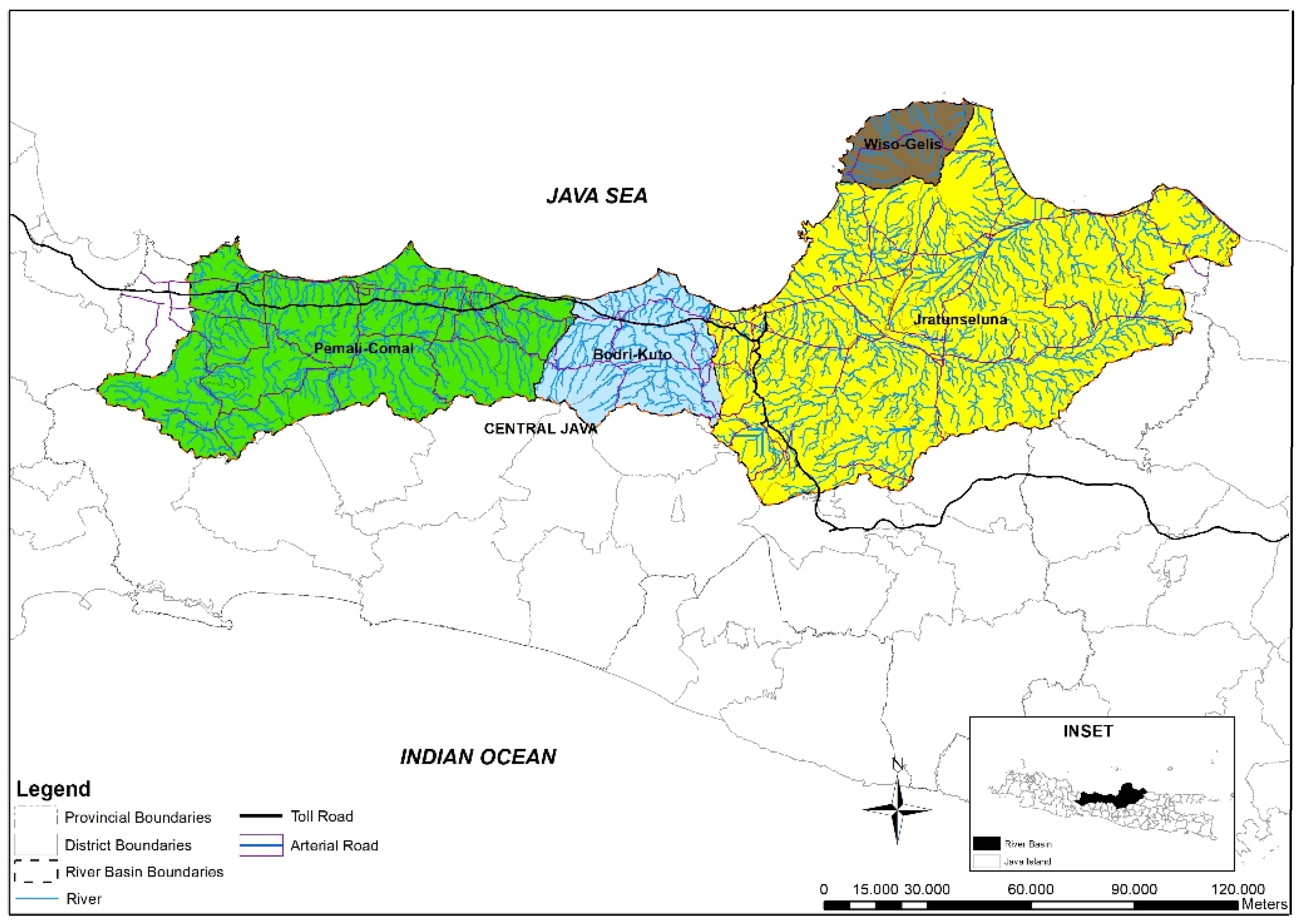
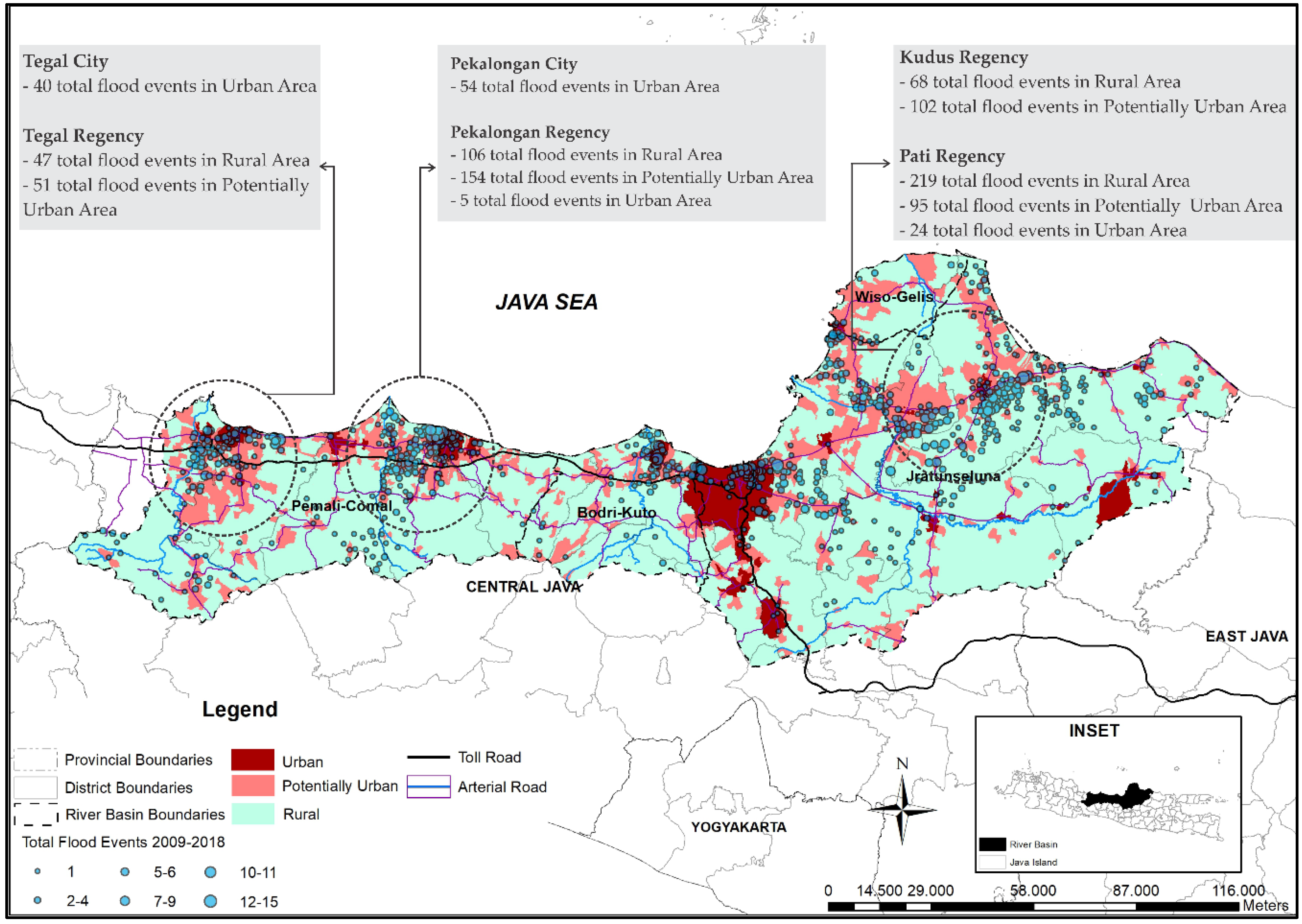
2.1. Study Area

Java is the most populous island in Indonesia. Its inhabitants constitute 60% of the total Indonesian population, even though it is less than 7% of the total area in Indonesia [24]. According to the Presidential Decree [25], the Island has around 1200 watersheds and 24 river basins. Some of them are categorized as National Strategic River Basins—meaning that their strategic socioeconomic and environmental functions should be preserved. Our study area is located in the mid-northern part of the Island (see Figure 1), which consists of four river basins. A large part of the area belongs to Central Java Province, which stretches through several local government authorities (or municipalities) that are categorized as either regencies or cities. The existence of arterial and toll roads in the northern corridor is an infrastructural boost that has led to rapid economic development in the area. Accordingly, some emerging threats on the functions of river basins are mostly triggered by uncontrolled population growth. Such growth results in the reduction in non-built-up areas, as forest and agriculture lands are converted to settlement and industrial zones.
Pemali-Comal, Bodri-Kuto, Wiso-Gelis, and Jratunseluna River Basins cover a total area of 16,403 km2 that cuts across four cities (Tegal, Pekalongan, Semarang, and Salatiga) and 17 regencies (Brebes, Tegal, Pemalang, Pekalongan, Batang, Kendal, Temanggung, Demak, Jepara, Kudus, Pati, Rembang, Blora, Grobogan, Sragen, Boyolali, and Semarang) (Figure 1). Table 1 highlights the main features of these basins. Jratunseluna is the biggest river basin in the study area. It is a National Strategic River Basin with several vital functions and a significant number of people living in the area. Indeed, proper governance/institutional setting is crucial in managing the basins, considering that the river basin areas are not under local authorities.
In general, as shown in Figure 2, rainfall in the four river basins fluctuated over nine years period. In most cities and regencies in which all basins, except for Pemali-Comal, are located, the rainfall increased from the previous year and peaked in 2010, followed by a sharp decline the year after. In Jratunseluna, the critical years with the highest frequency of rainfall were 2010, 2013, and 2016. Throughout 2010, 2014, and 2016, the rainfall in Bodri-Kuto continued to increase, peaking at approximately 3600 mm/year. In contrast, the average rainfall in Pemali-Comal River Basin considerably increased in 2012 and 2015 and then remained constant until 2018. However, the rainfall patterns in Wiso-Gelis River Basin, which covers only one regency and was generated from only one climatological station, differ from that of the other river basins. A steady increase was observed from 2009 to 2011 and 2012 to 2015, followed by a decrease in 2016.

2.2. Methods of Data Collection

2.2.1. Spatial Data

Remote sensing data were used to produce Land-Use-Land Cover (LULC) map for 2009 and 2018 30 × 30 m resolution to assess LULC change in Central Java North Coast. In addition, watershed data were used to delineate the river basin area according to Presidential Decree and Ministry Regulation. Table 2 details the spatial data that were processed for the analysis.

2.2.2. Urban and Rural Classification Data

Rural and urban areas are classified based on their administrative jurisdiction, Central Bureau of Statistics (CBS) criteria [26], as well as the direction of built-up area expansion. These resulted in three classifications, namely urban, potentially urban and rural areas. An area is classified as urban when its administrative jurisdiction lies in the city or the capital of a regency. Meanwhile, a potentially urban area refers to any area categorized as rural-urban according to the CBS criteria, in which its rural-urban potential is also considered (see Table 3).
To further comprehend the classification explained in Table 3, it is important to note that a village is the lowest administrative jurisdiction in Indonesia. Accordingly, there are three types of villages based on their rural and urban status. The first is desa, which are villages located in a regency and characterized as rural. The second is kelurahan, which are categorized as urban villages and are located in a city. Third, some villages are characterized as urban according to the CBS criteria, yet they are referred to as desa instead of kelurahan. Therefore, they are categorized as potentially urban. Another essential difference between desa and kelurahan is that the local residents elect the head of desa, while the head of kelurahan is appointed by the mayor or regent, both of which are government employees.

2.2.3. Disaster Data

The primary data source for flood events is the Disaster Management Board (DMB) of Central Java Province. According to DMB, based on the Law concerning Disaster Management [27], flooding is an event or condition where an area or land is submerged due to water volume increase. Flash flood, also known as fluvial flood, involves sudden water discharge in large volume due to river flow obstruction. The DMB flood data are based on a compilation of reports from local (City/Regency) government informing the location (name of villages/kelurahan), duration, depth, and damage/loss status. However, not all local governments have reported the events, as it is not an obligatory procedure. Accordingly, this study also investigated data on flood events and fatalities published by mass media websites or other institutions and used them to validate formal data released by the government. The internet-based data were collected using three keywords via Google search engine: flood, name of the district or city concerned, and the year of occurrence.
Data collection on flood events was performed by looking for news articles that contain information on flood location (sub-district and village or kelurahan), time of occurrence, height of inundation, the time required for inundation to recede (duration of inundation), and the magnitude of impact or loss due to flooding. Information search regarding flood events in regencies/cities and the specified year were deemed to be completed when the search engine (Google) detected that no more articles related to the keywords were found.
The news reports on flood events from 2009 to 2018 were collected, totaling in 2123 news pieces from approximately 98 sources, including the mass media or institutional website. The total number of flood events was 1925, of which 1609 were reported by one news source (single rapporteur), while the rest were reported by more than one news source (joint rapporteur). Table 4 describes the number of total incidents reported from five sources that had the largest contribution in disaster news. Formal government report only covers around 52% of the total incidents, showing that a significant number of incidents took place yet they were not formally reported to the authorized government.

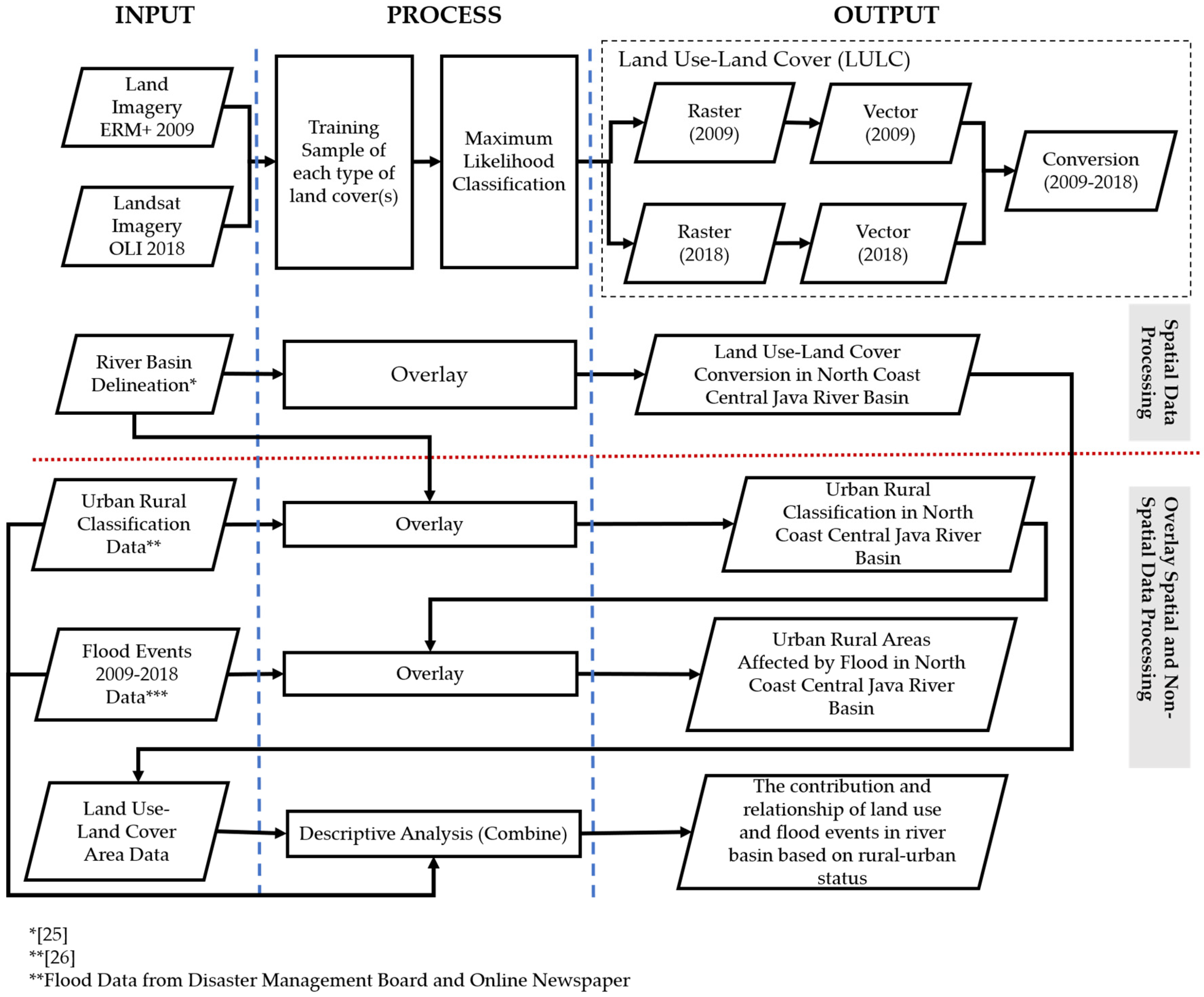
2.3. Methods of Data Analyses

This study uses two types of analysis: spatial data and non-spatial data analysis (Figure 3). The spatial analysis was focused on assessing LULC change in 2009–2018 based on Landsat Imagery. The non-spatial data (i.e., rural-urban classification and flood events) were overlaid with the results of spatial data analyses.
LULC was classified into five types based on the Indonesian National Standard Regulation [28], namely the built-up, industry, rice fields, forest, and mix plantations (see Table 5). Supervised classification was done on land cover imagery, in which the training sample was determined using Maximum Likelihood Classification in ArcGIS. The accuracy of tentative LULC produced in this step was confirmed through field observations and using the instrument conformity table, totaling in 306 observation points. This was then used to improve LULC interpretation.
As illustrated in Figure 3, the result of spatial data analysis was overlaid with two data attributes at the village level; i.e., rural-urban classification and flood events. This step combined urban-rural classification data (as explained in Table 5) and flood events with river basin classification and land-use change in 2009–2018. In the next stage, descriptive analysis was conducted to identify the relationship between land use changes, i.e., from built-up to non-built up areas, with the occurrence of flood over nine years period. In this case, a matrix composed of four elements, including river basin, urban-rural status, land use change and flood events, was generated. The built-up areas consist of settlements and industrial areas, while the non-built up areas include forests, rice fields and mix-plantations.

3. Results or Outcomes

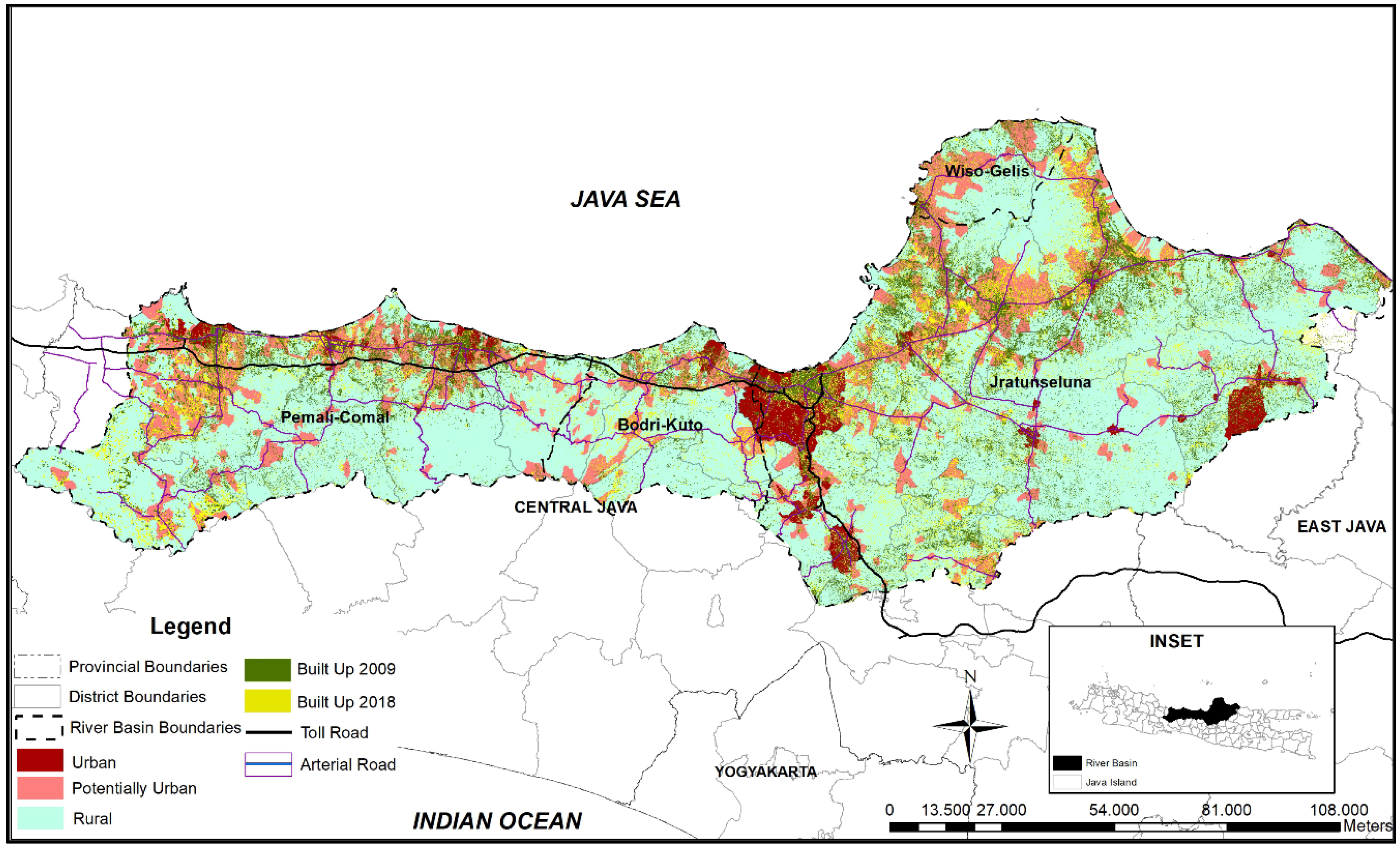
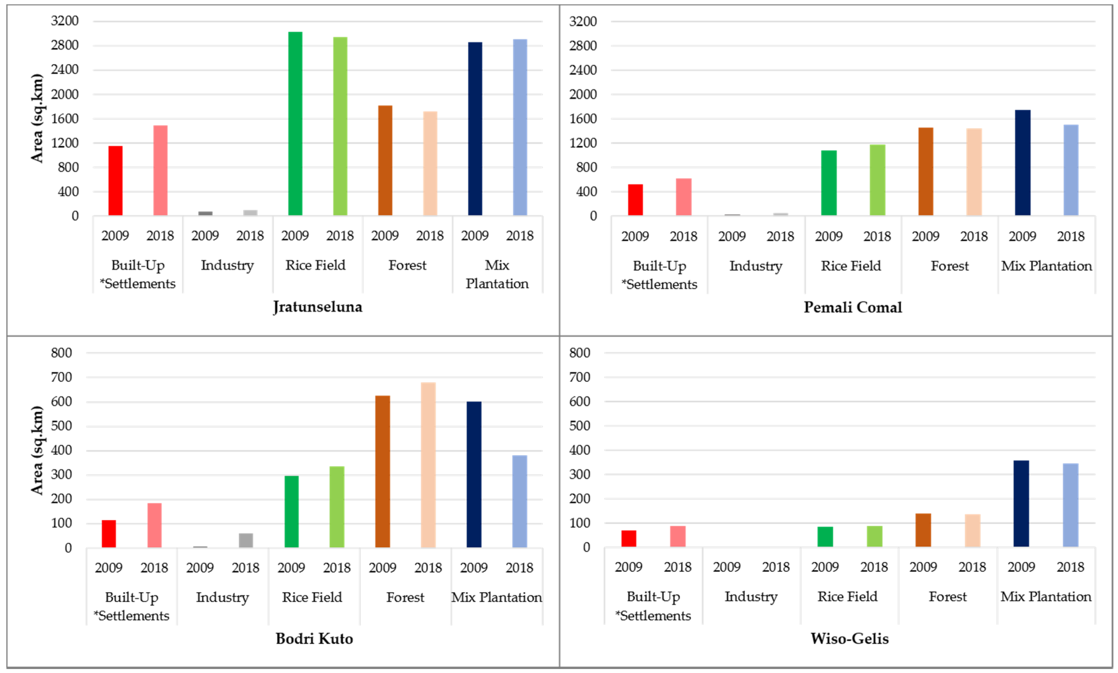
3.1. Land Use Change in the Northern Coast of Java 2009–2018

Significant urban expansion has taken place in the Northern Coast of Java. The land conversion rate for each river basin based on its rural-urban classification is listed in Table 6. Each basin has a particular growth rate pattern. Bodri-Kuto River Basin experienced the most critical changes (up to 108%) over nine years compared to the others, which means that massive built-up development occurred in this river basin in terms of settlements and industrial area. It is then followed by Jratunseluna River Basin, in which the built-up area has expanded from 1222 to 1581 km2 since 2009 to 2018. Most of the expansion took place in the urban area at approximately 137%. Meanwhile, the development of Pemali-Comal River Basin mostly occurred in the potentially urban area (43.31%), specifically in Tegal and Pekalongan Regency. The growth of built-up area in Wiso-Gelis was significantly higher in the rural area (36.13%) than in the potentially urban (17.54%) and urban (10.08%) areas. This scenario is indicative that substantial urbanization within the study area [7] has led to a significant land conversion that expanded to rural areas surrounding the urban centers. On the governance side, administrative autonomy, which devolves the authority over land use allocation to local government, has led to uncontrollable land conversion due to a lack of coordination among local governments.
The land conversion status for each river basin varies. Bodri-Kuto River Basin experienced the highest rate of land conversion to built-up areas over nine years, followed by Jratunseluna, Wiso-Gelis and Pemali-Comal, respectively. The highest increase in built-up area is in the urban area of Jratunseluna River Basin. In contrary, in Pemali-Comal and Bodri-Kuto River Basin, there was a significant increase in built-up area in the potentially urban area, specifically in Tegal and Kendal Regency.
As illustrated in Figure 4, the increase in built-up area was not only concentrated in urban areas. Among the three river basins, there was a significant development in potentially urban and rural areas during the 2009–2018 period. Thus, growth in potentially urban areas is also influenced by nearby urban activities. Accordingly, urban expansion is extended to areas surrounding the city centers even though there are more vacant lands available for use. Toll road development and industrial zone establishment have very much influenced the growth and direction of land conversion. To illustrate this, the land allocation for industrial lands in Bodri-Kuto increased significantly, from less than 10 km2 to more than 60 km2. This is then followed by the expansion of residential and commercial activities in surrounding areas to accommodate the needs of industrial employees.
Figure 5 further illustrates land-use changes in several types of land allocation. Rice fields, forests and mix plantations are dominant throughout the river basins. However, there was a considerable loss of mix plantation land in most of the river basins, except in Jratunseluna. Bodri-Kuto experienced the highest loss of mix plantation areas (that is up to 221 km2 between 2009 and 2018), followed by Pemali-Comal (13.98%) and Wiso-Gelis (3.28%). In all river basins, the loss of mix plantation areas occurred in potentially urban areas, for example in Tegal, Pekalongan and Demak Regency. Despite the significant reduction in land use for mix plantations, Figure 4 depicts that there was a slight increase in the rural forest area in Bodri-Kuto which went up to approximately 53 km2 over nine years. Growth of forest area within some river basins in Central Java is in line with the enacted regulations of the Governor of Central Java [29] and the Minister of Environment and Forestry Regulation [30]. The regulation provides evidence that a policy should serve as a strategic instrument in controlling land allocation and improving river performance.
The increase in built-up area, especially in certain regencies or rural areas, occurred because land has been converted into rural-urban potential areas, and at some point, urban areas. Within this scenario, in the near future Java will become an urban island, on which built-up areas will expand downstream to upstream, overall creating problems in the environment. Based on the built-up ratio in 2018 (which categorizes the area as a rural-urban potential area), more than 600,000 inhabitants are spread throughout approximately 250 villages. This indicates that more rural areas have been urbanized due to the increasing population and expanding built-up area. For example, Pati Regency has the highest number of villages belonging to the potentially urban area (129 villages), followed by Kudus Regency, where 113 villages are potentially categorized as urban areas. Both regencies are located at the downstream of Jratunseluna River Basin.

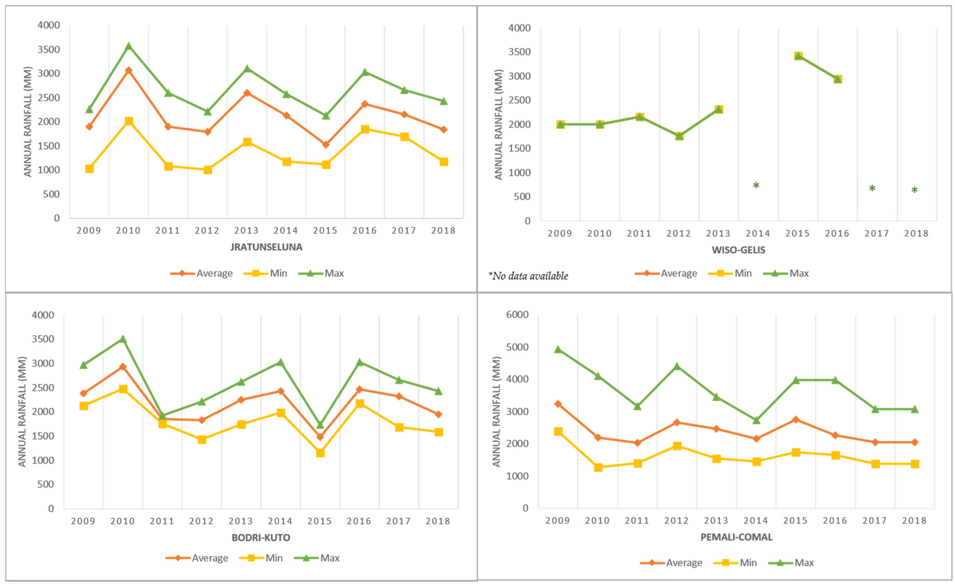
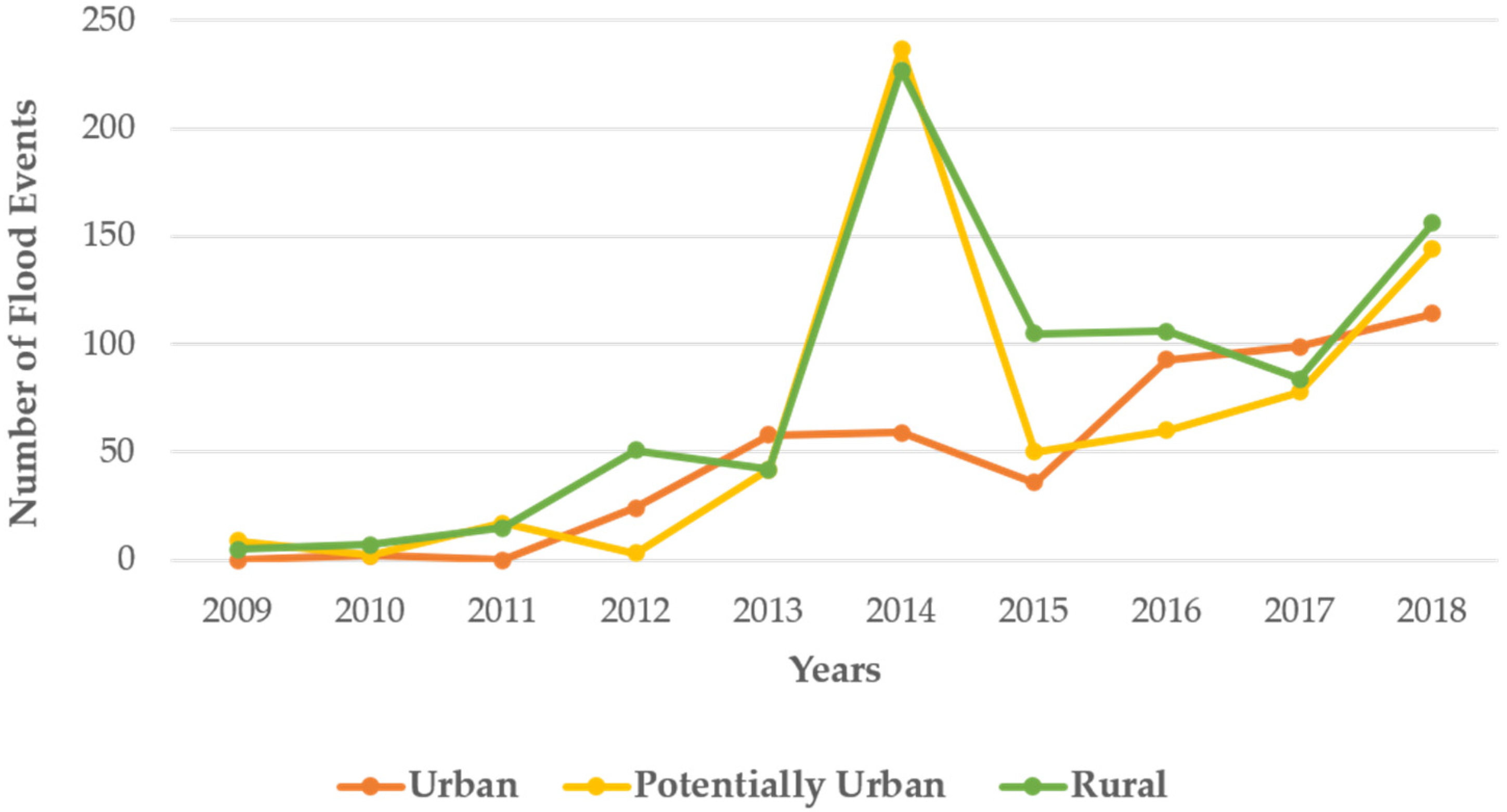
3.2. Flood Events in the River Basins

The frequency of flood in the four river basins fluctuates. There are limited data for flood events in the initial years (2009–2011) because the local disaster management board has yet been established and the mass online media have not been widely used in reporting disaster news in details. Accordingly, in 2009–2011, a small number of floods occurred in all areas, including in the urban, rural-urban and rural areas (Figure 6). The number of floods in the rural and urban areas has increased in 2012 and 2013 since the disaster data report has been updated. In addition, in 2014, flood occurrence sharply increased, especially for the rural-urban areas. In the rural areas alone, there were more than 200 incidents of flooding reported. Two of the most prominent river basins in the study area, Jratunseluna and Pemali-Comal River Basin, contribute to a high number of flood events. Specifically, up to 2014, a majority of flood events in the Jratunseluna River Basin happened in namely Pati, Kudus and Jepara Regency. Meanwhile, in the Pemali-Comal River Basin, the Pekalongan Regency contributes to a massive number of flood incidents.
It is notable that the peak of flood events on the North Coast of Central Java occurred in 2014, followed by a dramatic drop in 2015 and a steady increase afterwards up to 2018. On average, the height of flood in the study area is 20–40 cm. The flood duration varies from less than one hour to more than 24 h. In more detail, 56 out of 925 flood events analyzed in this study reached a height of 1.5 m or more and are categorized as severe flooding. This occurred mainly in Pati Regency, Rembang Regency and Semarang City, which are part of the Jratunseluna River Basin, and in several cities or regencies within the Pemali-Comal River Basin, including Pekalongan City and Pemalang Regency. In particular, the worst flood reached up to 3.5 m in Pemalang Regency in 2018. In addition, 259 flood events were up to 1-m high, most frequently in Kudus, Pekalongan and Jepara Regency.
Figure 6 presents the number of floods in the urban, potentially urban and rural areas surrounding river basins over the past nine years. It is evident that flood mostly took place in the rural areas rather than in the urban and rural-urban areas. The total number of flood events in urban, rural-urban, and rural areas in 2009–2018 was 485, 642 and 798 incidents, respectively. Flooding is very much influenced by rainfall intensity. The expansion of urbanization promotes flooding due to the increase in total impervious areas, leading to excessive rainfall. In addition, disaster risk reduction initiatives are also of importance.
In the study area, flood events occurred during the rainy season. It was identified that 70% of flood events happened in January to March, during which the highest frequency of rainfall was reported, especially in 2014. For example, Pekalongan Regency contributed to the most significant flood events in 2014 (around 45%). According to the Meteorological, Climatological, and Geophysical Agency [31] the highest rainfall in Pekalongan Regency was recorded in January–February, at 991 mm and 1117 mm per month, respectively. In contrast, the rate of rainfall in the same month of the previous and following years was lower, at approximately 500–800 mm per month [32,33]. As revealed by other studies on rainfall patterns, since 2003, Java Island had a shorter term and higher intensity of rainfall [34]. Siswanto and Supari [35] revealed that extreme rainfall in Java tends to be irregular, in which such event is spatially distributed across the island and the positive and negative trends are proportional.
Figure 7 further illustrates flood events in each river basin. Jratunseluna, the biggest river basin, experienced the highest number of floods compared to other river basins. The flood events were concentrated in specific flood-prone areas, namely the Pati Regency, Kudus Regency and Semarang City, all of which represent the rural, potentially urban, and urban characteristics within Jratunseluna River Basin. In total, there were 1057 flood events in Jratunseluna River Basin, accounting for up to 48% of total flooding in the rural area over nine years. The rural area of Pati Regency contributed to the highest frequency of flood events, amounting to 219 out of 509 events spread out through 88 rural villages. In addition, up to 31% of flood events in Jratunseluna happened in the potentially urban area, with Kudus Regency experiencing the highest flood frequency with 102 flood events spread throughout 28 villages. In the urban areas, the highest frequency of flood events was recorded in Semarang City, which contributed up to 80% of total urban flood events spread throughout 26 kelurahan in 2009–2018. Flood events in the urban area continued to increase considerably over nine years, in contrast to the fluctuating flood in rural and potentially urban areas. The worst flood event in Jratunseluna River Basin took place in Grobogan Regency in 2013, which inundated approximately 5000 houses due to broken embankments. Demak Regency was also hit by severe flooding (1–2 m in height) in 2017, forcing 1450 households to abandon their homes. For the case of Jratunseluna, floods mostly hitthe rural area compared to the urban and potentially urban areas.
Similarly, the flood events in Pemali-Comal River Basin peaked in 2014, with up to 236 incidents. In total, there were 671 incidents throughout 2009–2018 in the region, spreading through 290 villages dominantly categorized as potentially urban areas. In detail, the number of flood events in potentially urban area within Pemali-Comal River Basin was up to 269 flood events, which contribute to approximately 40% of total incidents. Significant built-up land expansion (39%) in the potentially urban areas within Pemali-Comal River Basin was also observed, followed by a rise in flood events in those areas. Pekalongan had the most significant number of flood events compared to other regencies, with 154 incidents spread throughout 46 potentially urban villages. In respect to flood events in rural areas, Pekalongan Regency also contributed to the most significant number (43%) of total incidents. In Pemali-Comal and the Jratunseluna River Basin, flood incidents in the urban areas were less frequent than in the rural and potentially urban areas. Interestingly, flooding was more frequent in Pekalongan City compared to in other cities/regencies, which contributed up to 30% of total incidents in the urban area. Additionally, Tegal City and Brebes Regency also contributed to a high number of floods at approximately 25% and 24% of overall urban floods, respectively. This indicates that most villages on the coast of Pekalongan and Tegal Greater Area are prone to flood. More than 10 floods events occurred over nine years in the most flood prone villages within both river basins. Severe flooding in Pemali-Comal River Basin took place in Pemalang Regency in 2018. Due to river runoff following heavy rainfall, a flood as high as 3.5 m inundated thousands of houses in several villages.
With their smaller size compared to Jratunseluna and Pemali-Comal, there were fewer flood events in Bodri-Kuto and Wiso-Gelis River Basins. In Bodri-Kuto, there was a considerable fluctuation of flood events from 2009 to 2017, which peaked in 2018 with 53 flood events. Approximately 90% of flood events in this river basin occurred in Kendal Regency, while the rest took place in Semarang City. The urban area of Bodri-Kuto River Basin has the highest contribution of flood events at 60% of total flood events spread throughout 16 villages. It mainly occurred in Kendal Regency, where 13 flood events were reported at the village level. As noted by the Disaster Management Agency [36], flooding in Kendal urban area was caused by river runoff and low drainage capacity for water conveyance. Meanwhile, there was a slight increase in flood events in potentially urban and rural villages in Bodri-Kuto, amounting to 36 and 37 flood events during the nine-year period, respectively. The worst flood in Bodri-Kuto River Basin took place in Kendal Regency in early 2014, during which almost ten districts were affected by a 1.5-m flood.
Similarly, Wiso-Gelis as the smallest river basin experienced the worst flood around 1–1.5 m in height in 2014. The flood submerged 990 houses in Jepara Regency. In total, 17 flood events were recorded from 2009–2018. This shows that flood events mainly occurred in four villages within the rural and urban areas, in which with the number of flood events in the rural area was slightly higher than in the urban area. Accordingly, there is an indication that floods occur only occasionally in the potentially urban areas of the river basin. Since 2016, flooding in the Wiso-Gelis River Basin has been trending negatively, as shown by the decreasing number of flood events in the urban, potentially urban and rural areas of this river basin.

3.3. Land Use Change and Flood Phenomenon in River Basins

The population of Java has significantly grown from four million (at the beginning of the 19th century) to 40 million (in the early 20th century), to more than 150 million inhabitants in 2018 [37,38]. Moreover, the population within our study has increased from 17.1 million in 2009 to 18.3 million lives in 2018. Population growth led to significant land conversion and deforestation, which creates an impact on water cycle and rainfall pattern. Longer dry seasons lead to significant water supply problems, as the area keeps developing and experiencing rapid population growth. A previous study [39] showed that during the dry season (June and July), the rainfall patterns in most parts of Indonesia, including Central Java, tend to deviate from its normal conditions.
The overall contributions of land use and flood events over nine years (between 2009 and 2018) within four river basins are shown in Table 7. Approximately 80% of the river basin areas belong to the non-built-up area, which consists of rice fields, forests and mixed plantation areas. However, at the same time, the overall built-up area also increased significantly in all river basins, while the non-built up area decreased. Bodri-Kuto River Basin showed the highest loss in non-built up areas. In 2018, the non-built up area contributed to 85% of the total area within this river basin, while in 2009 the percentage was higher. Nonetheless, there was an upward trend of non-built up area in urban part of Jratunseluna in 2018, which was sharply expanded up to 30%. In contrast, the non-built up area in all other river basins showed a downward trend. The rise of the non-built up area in urban part of the Jratunseluna River Basin was caused by the transformation of settlement areas into mixed plantations or wetlands. For example, in the shoreline of Semarang City and Demak Regency, the increase in non-built up area occurred due to erosion in the area [40]. Accordingly, coastal erosion and inundation have caused a substantial loss of coastal land surrounding Demak Regency. Water as Leverage for Resilient Cities Asia Program Report [41] explained that Semarang’s dynamic shoreline has been shifting faster over the last decade due to the changing climate and land subsidence, eroding mangrove areas, fishponds, villages and city assets. Moreover, the area of Demak Regency has experienced the most significant coastal erosion and loss of mangroves and aquaculture.
A significant exposure to flood has taken place in the urban and potentially urban areas following the increase in built-up areas (Table 7). Flood events are more frequent in the urban and potentially urban areas, most of which are located nearby the coastal line. This is also in line with a previous study by Rudiarto et al. [7,42], where 40% of flooding events were found within the range of 10 km from the coastline, while 80% of tidal flooding was distributed mostly in the areas of less than 5 km from the coastline. Flooding is a result of various factors, and urban flooding is not only mostly caused by water overflowing from the river (fluvial flooding) but also by land conversion in combination with weak drainage systems (pluvial flooding). As flooding is more common in the urban areas, which means that densification has a significant influence on the increasing event of pluvial flooding. Densification typically occurs due to the conversion of agricultural land into settlement and industrial land, leaving a lot of the areas vulnerable to flooding [43]. It is likely that the number of rainy days significantly decreases with higher rain intensity. This very much influences the surface water runoff and put more pressure on the river and drainage systems. Robust and adaptive drainage arrangements, therefore, is of importance in this circumstance.
Aside from pluvial flooding (which happens mostly in urban fabric area), fluvial flooding (which occurs because of the overbank of the water from the river) also has a significant influence in the rural-urban and rural areas. In this regard, it is caused by land-use change that transforms forests in the rural area into a built-up area. Some rural areas have been hit by intensive flooding, especially in the Jratunseluna and Wiso-Gelis River Basin, which contributed to more than 40% of the total flood events over nine years (Table 7). However, flooding in this region is not only connected to deforestation, but also to in situ urbanization. Handayani [44] found that industrialization at the rural level is happening in Central Java. This type of industrialization may potentially lead to the increase in flood risk in areas that are not necessarily located in the big urban center.

4. Discussion and Issues Emerging from the Study

The results that emerged from this study have some implications to the urban development and policies. This study reflects that land use dynamics would depend on policy decisions and implementations for improvement. Sufficient comprehension on policies at the river basin level is an essential prerequisite in flood risk management. For the sake of solution-oriented discussions, two issues emerged from this study. First, the need to create a better understanding on urbanization and flooding phenomena, to raise more solution-oriented awareness through land use policy. This is crucial, especially in countries like Indonesia. For that reason, the authors have put an emphasis on Indonesia through case studies. Second, there is a need to identify the role of governance in flood management, particularly in curbing urban flooding. Both issues are discussed further in the following sections.

4.1. River Basins Have Dual Spatial Identity that Embraces Policy and Land Use Issues in the Urban System

Knowledge concerning river basins dynamics in the urban system is still vague. It is, in most cases, simply viewed as a landscape or an appendage of water bodies [45]. Though it is often used as a point of departure in discussing several issues related to urbanization, it is unduly taken for granted in terms of its functions in the urban system. The analytical aspect of this study offers a renewed systematic way of looking at river basins as a sub-ecosystem embedded within the urban system, and as a concept in the urban discourse. As can be deduced from the case presented in this study (at least in the context of Java), river basins have a dual spatial identity in the urban system. It is both a natural land object, as well as a form of land use.
A river basin is a part of the land because it is a section of the “earth surface with all physical, chemical and biological features” [46] (p. xix). It can be viewed as a land object because it is uniquely embedded to (as well as a natural embodiment of) the physical urban system, and yet are distinguishable in legal (invisible) ecosystems recognized in policies, laws and statutes. In fact, within the land administration system, the river basin can be categorized as a cadastral object and as a unique legal entity, which can be both fiat (i.e., invisible) and bona fide (i.e., visible). It has a boundary and can be surveyed and measured in physical, ecological, socioeconomic, and cultural terms. It can also be viewed as a “property”, because it is the embodiment of several “set of rights and a set of duties or obligations” (including interests and privileges) that subsist in the urban land, which the urban people expect to leverage or enjoy [47] (p. 2). Hence, it has various forms of values attached to it—including ecological, economic, political, cultural, social, touristic, aesthetic, and other urban functional values. As a result, a river basin should be viewed as a portion of land meant to be administered, managed, and controlled to ensure that it fulfils its function within the urban system. In this regard, flooding is a negative consequence of the relationship between a river basin and its urban surroundings, which makes the area unavailable to urban people.
River basins also constitute an essential type of land use in the urban system. The perspective of conceiving the river basins for land use is best illustrated by answering the question: why do urban people want to live around a river basin? In the context of Java, the river basin is a sub-system that embodies vegetation and waterways required for food, energy, water, biodiversity, and shelter, among many others. It serves a cooling effect in the urban heat island concerns [48]. Hence, river basins constitute land use because they are part of the decisions people make regarding land or natural resources available to them within permissible natural and administrative restrictions. Land use is, therefore, a purposeful intervention made by humans concerning what and how to exploit, explore, protect or conserve aspects of the land system [49,50]. Urban river basins are, therefore, subject to land use adoptable by urban people according to permissible natural and legal (or administrative) characteristics, leading to transformations in the way they live in the urban system.
How does the above idea relate to tackling urban flooding? The dual spatial identity of river basins (both as a land object and land use in the urban system) offers an opportunity to mitigate flooding, mostly in coastal areas. However, it will also pose a threat if it is not managed well. In the case of Java, it can be argued that built-up area expansion to the upstream area of the river basins lead to significant negative consequences. Not only it threatens the food and water supply sustainability (referring to river basin as land), but it also generates issues in infrastructure provision (such as to manage flood) and ownership due to rapid settlement growth in areas that play a strategic role in the river system (conflict of interest regarding land use).
Chen et al. [17] argue that, based on the experience in China, the sprawling built-up land increases the difficulty and costs to deploy and manage hazard-resistant infrastructures, construction-wise. Accordingly, the compact city concept is perceived as the most sustainable urban form to limit the uncontrolled effects of infrastructure provision caused by the need to contain urban growth. Global urban sprawl usually leads to the increase in emission load due to the increased use of transportation. However, what is usually not written much about is that sprawl development causes problems that limit water conveyance and supply. Rudiarto et al. [7] stated that the urbanization of north Central Java has been very significant since the 1990s. This is followed by the increase in climate disasters, as shown by incessant floods. Handayani and Rudiarto [51] have further examined this phenomenon in Semarang Metropolitan, the biggest urban center in the area. In this regard, Douglass [2] argued that it creates an urban disaster in Asia, a situation where agglomerations affect urban areas. Thus, there lies an urgent call to focus on urban growth management in an integrated framework following an ecosystem-based (or eco-based) regional approach. An eco-based approach would involve conceiving the river basins as a unique ecosystem and employing a wide range of ecosystem management activities to reduce the vulnerability of urban people and urban environment due to flooding. In this regard, the approach would tackle urban challenges that arise from the location of river basins. Hence, whereas flooding is a critical problem linked to the river basins, it can be mitigated as part of broader ecological system management.
Focusing on the use of urban infrastructure provision to check flood events, Zhou et al. [19] have shown through their study that the drainage system is vital in reducing the risk of urban flood. Based on several cases in major cities in Northern China, they [19] revealed that the frequency of flooding is caused by the lack of or failure in the urban drainage system. A similar case in the UK [52] revealed that drainage is essential in reducing flood risk, since flooding is very much influenced by urban densification and changing rainfall patterns. Accordingly, a proper drainage system is very critical to accommodate water conveyance during intensive rainfall. Even though there is still much debate on this matter in Indonesia, just as in the UK, there is evidence of a change in rain patterns in Java due to rapid urban growth and deforestation [37,53]. The number of rainy days is likely to decrease significantly but with a higher intensity of rainfall. This very much influences the surface water runoff and puts more pressure on the river and drainage systems. Such situation requires robust and adaptive drainage arrangements.

4.2. There Are Several Opportunities to Broaden the Role of Governance in Flood Management

Any serious effort to tackle urban flooding induced or influenced by the river basins demands the problematization of river basins, that is, viewing them as a problem that requires a solution. This is important in urban policymaking or urban reform efforts that are targeted for urban flood management. Historically, river basin development “has been used to structure water resource management” [54] (p. 839). Evidence from cases presented in this study shows that the management of river basins, if geared towards solving the flood problems, would have a mitigative effect in controlling the situation.
Understanding the opportunities for flood management through governance should be a critical aspect of urban development. The governance of river basins in specific, or water resources in general, would allow urban administrators to explore various technical and socio-political strategies to mitigate flood at various levels (basin, local, regional and national). Consequently, a governance approach capable of addressing both general urban issues and flood challenges is imperative. Governance-related urban policy instruments can serve as an essential factor in ensuring proper flood intervention to manage urbanization and flood prevention. In this regard, Friend et al. [55] argued that there is always a gap between policy planning and implementation, while there is a need for communication and negotiation among actors.
In the context of Java, such interactions are even more critical in respect to flood prevention, as there are many authorities with different roles and functions that manage the river basins (Figure 8). Both vertical and horizontal coordination are needed to ensure integrated policies. Vertical coordination is essential because the National Government (i.e., the Ministry of Public Works through the River Management Centre) is responsible in managing the rivers from upstream to downstream, while the drainage systems that cross through two different regencies are under the responsibility of the Provincial Government. Institutions at different levels of authority need to work intensively with the local governments (cities and regencies) in regard to the river basin management. This involves spatial planning policies that include various infrastructure provisions under the local government authority. Accordingly, horizontal coordination is also crucial, mostly because urban expansion due to rapid urbanization takes place beyond the administrative jurisdiction. Indeed, integration and collaborations would enable more sustainable urbanization.
In principle, the governance arrangement reflects subsidiarity. Each level deals with a specific role and decision making is made at both the top and the lowest level. However, in practice (and focusing on the river basins), decision making in water management is not made at the lowest level, where water is used. The national and provincial authorities are the ones who carry out the roles of river management and drainage systems, respectively. This, therefore, leads to the need for better interagency collaborations to allow for effective communication and the co-designing of strategies for action.
It is essential to introduce governance in flood management. However, this is a relatively new concept that needs to be discussed further [2,56]. The term becomes vital in current situation because the issue of flooding cannot be solved by one sole organization. After all, it is a multifaceted challenge that affects housing, farming and forestry as well as transport, among many others. It requires an effective decision-making process that involves various sectors and authorities. It also prompts integrated approaches that are certainly not limited to infrastructural work [57,58]. For this reason, Hegger et al. [13] categorized five types of strategies in flood risk management: flood risk prevention, flood defense, flood risk mitigation, flood preparation and flood recovery. According to Hegger’s strategy typology, land-use change should be controlled through proper spatial planning and this may serve as a policy instrument for flood risk prevention. However, it is interesting to note that based on Hegger et al.’s [13] and Raikes et al.’s [59] investigation in selected countries across the globe, there is still a lack of integration among the different types of strategies in place. Policies related to water supply, flood management and spatial planning are also fragmented. Despite that, both scholars [13,60] also argue that fragmentation is inevitable, because there are many strategies involved and each country has their own policy direction on flood management, with varying strengths and weaknesses.
Raikes et al. [59] reveal that most government policies are more focused on infrastructural work rather than on comprehensive flood prevention (through spatial planning policy). Handayani et al. [16] hold a similar position based on their two case scenarios, also done in Indonesia. Accordingly, Pardoe et al. [58] argued that infrastructural work will not be sufficient to accommodate the balance among land, people, and water interactions. Instead, Pardoe et al. [7] proposed a holistic policy instrument, which is vital to ensure the availability of a sustainable space for people and water. Many countries around the world have their own country-specific strategy for managing flood situations. The Netherlands with the concept of “Room for the River” [60] (p. 369) and the UK with “Making Space for Water” [61] (p. 534) approach demonstrate a case on how flood could be managed through suitable land use allocation.
There is, indeed, a responsibility of the government to provide public infrastructures to mitigate flood events. Infrastructure provision requires not only technical capacity and funding but also proper coordination among different government institutions. A considerable amount of investment allocated for significant infrastructural work for flood prevention will only act as a short-term and reactive solution rather than a long-term one. On the other hand, there is an increasing role of developers, since most of the land is owned privately. They are dominant players in developing industrial and housing estates, which are regarded as major land conversion within the study area. Accordingly, collaborations with private sectors (landowners) is an excellent opportunity to further manage river basins, mostly to mitigate flood, which is unavoidable in the situation where urbanization (i.e., land conversion) has spread through the whole area.

5. Conclusions

Limited attention has been paid to the potential effects of river basins on urbanization-associated floods. In general terms, it is well known that “most cities are historically developed near rivers or oceans to ensure the supply of water” [62] (p. 1). It is therefore not surprising that Indonesia—a country surrounded by waters from many rivers—has cities that are located around waters. Therefore, this study confirms Zhang et al.’s [63] (p. 384) thesis that the process of urbanization “exacerbates flood responses” in low-lying areas. Using this case study, we identified possible urban land use components of the global urban flooding crisis. This also implies that rapid urbanization, in addition to the lack of land-use planning (or inappropriate implementation of the plan), have increased the amount of land exposed to floods [62] (p. 1). One key issue deduced from this study is that there is a relationship between flooding and urbanization. However, such a relationship may not always be straightforward. It can vary from country to country depending on their respective planning and development strategies, human behavior or response to flood and urbanization scenarios; and most importantly, the role of governance in the management of floods. From the context of land use and management, this study has shown that the river basin is a linkage factor or object in the flood–urbanization relationship.
The study highlights the importance of investigating the role of river basins in impacting flood events in highly urbanized areas. Disaster risk reduction through proper land use planning and controlling is an essential instrument for safeguarding urban areas (such as the case study area, and the entire island of Java in Indonesia). This provides an opportunity to sustain coastal or island settlements and prevent them from being converted into urban islands, which may face complex environmental issues, including extreme precipitation or water-related disasters, and hydrometeorology-associated events. However, without proper management measures, technical measures alone are not sufficient to improve this situation. In this regard, the role of governance in flood management is crucial. This aspect is a missing link in the urban environmental risk management strategy in Indonesia. The country’s decentralization policy, which has been in operation since 1999, has led to a cumbersome coordination process for land use allocation instead of a solution-oriented one. Due to the decentralization policy, the local government is lacking in authority in this context. Instead, each local or municipality government is focused on the economic development, which is highly dependent on massive land conversion with no recourse to geographical delineations of the river basins. Such action will continue to bring dire environmental consequences, especially given that no appropriate actions have been taken to alleviate them. Hence, the effect of urban land-use on extreme precipitation and flooding should be studied more explicitly. The study presented in this paper is an urgent call to comprehend urbanization beyond a mere administrative-based process. Urban environmental risks generated from urbanization can be mitigated by understanding their land use components. We hope that this study will motivate other scholars from the Global South to investigate the role of river basins in other urban areas in search of solutions for sustainable environmental risk governance in urban areas.

Author Contributions

Conceptualization, W.H. and U.E.C.; methodology, W.H. and I.R.; Resources, W.H., I.R., U.E.C., and I.H.S.P.; Formal analysis, W.H., I.R., and I.H.S.P.; Investigation, W.H., I.R., and I.H.S.P.; writing—original draft preparation, W.H., I.R., and I.H.S.P.; writing—review and editing, W.H. and U.E.C.; Validation, W.H., I.R., U.E.C., and I.H.S.P.; visualization, I.H.S.P. All authors have read and agreed to the published version of the manuscript.

Funding

This research was funded by Diponegoro University and Ministry of Research, Technology, and Higher Education Indonesia, and the APC was funded by Technical University of Munich.

Acknowledgments

Acknowledgment is given to the Director General of Higher Education, Ministry of Research, Technology, and Higher Education Indonesia, Diponegoro University, and Technical University of Munich for supporting this research. This publication was supported by the German Research Foundation (DFG) and the Technical University of Munich (TUM) in the framework of the Open Access Publishing Program.

Conflicts of Interest

The authors declare no conflict of interest.

References

  1. Deng, X.; Xu, Y. Degrading Flood Regulation Function of River Systems in the Urbanisation Process. Sci. Total Environ. 2018, 622, 1379–1390. [Google Scholar] [CrossRef] [PubMed]
  2. Miller, M.A.; Douglass, M. (Eds.) Disaster Governance in Urbanising Asia; Springer: Singapore, 2016; pp. 1–12. [Google Scholar]
  3. Sarauskiene, D.; Kriauciuniene, J.; Reihan, A.; Klavins, M. Flood Pattern Changes in the Rivers of the Baltic Countries. J. Environ. Eng. Landsc. Manag. 2015, 23, 28–38. [Google Scholar] [CrossRef] [Green Version]
  4. Adhikari, P.; Hong, Y.; Douglas, K.R.; Kirschbaum, D.B.; Gourley, J.; Adler, R.; Brakenridge, G.R. A digitized global flood inventory (1998–2008): Compilation and preliminary results. Nat. Hazards 2010, 55, 405–422. [Google Scholar] [CrossRef]
  5. Bertilsson, L.; Wiklund, K.; de Moura Tebaldi, I.; Rezende, O.M.; Veról, A.P.; Miguez, M.G. Urban flood resilience—A multi-criteria index to integrate flood resilience into urban planning. J. Hydrol. 2019, 573, 970–982. [Google Scholar] [CrossRef]
  6. Buchori, I.; Pramitasari, A.; Sugiri, A.; Maryono, M.; Basuki, Y.; Sejati, A.W. Adaptation to coastal flooding and inundation: Mitigations and migration pattern in Semarang City, Indonesia. Ocean Coast. Manag. 2018, 163, 445–455. [Google Scholar] [CrossRef]
  7. Rudiarto, I.; Handayani, W.; Setyono, J.S. A Regional Perspective on Urbanisation and Climate-Related Disasters in the Northern Coastal Region of Central Java, Indonesia. Land 2018, 7, 34. [Google Scholar] [CrossRef] [Green Version]
  8. McGranahan, G.; Balk, D.; Anderson, B. The rising tide: Assessing the risks of climate change and human settlements in low elevation coastal zones. Environ. Urban. 2007, 19, 17–37. [Google Scholar] [CrossRef]
  9. Neumann, B.; Vafeidis, A.T.; Zimmermann, J.; Nicholls, R.J. Future Coastal Population Growth and Exposure to Sea-Level Rise and Coastal Flooding—A Global Assessment. PLoS ONE 2015, 10, e0118571. [Google Scholar] [CrossRef]
  10. Deng, X.; Xu, Y.; Han, L.; Song, S.; Yang, L.; Li, G.; Wang, Y. Impacts of Urbanisation on River Systems in the Taihu Region, China. Water 2015, 7, 1340–1358. [Google Scholar] [CrossRef]
  11. Chin, A. Urban Transformation of River Landscapes in A Global Context. Geomorphology 2006, 79, 460–487. [Google Scholar] [CrossRef]
  12. Chigbu, U.E.; Kalashyan, V. Land-use planning and public administration in Bavaria, Germany: Towards a public administration approach to land-use planning. Geomat. Land Manag. Landsc. 2015, 4, 7–17. [Google Scholar] [CrossRef]
  13. Hegger, D.L.; Driessen, P.P.; Wiering, M.; Van Rijswick, H.F.; Kundzewicz, Z.W.; Matczak, P.; Crabbé, A.; Raadgever, G.T.; Bakker, M.H.N.; Priest, S.J.; et al. Toward more flood resilience: Is a diversification of flood risk management strategies the way forward? Ecol. Soc. 2016, 21, 52. [Google Scholar] [CrossRef]
  14. ISDR. Hyogo Framework for Action 2005–2015: Building the Resilience of Nations and Communities to Disasters. In Proceedings of the World Conference on Disaster Reduction, Kobe, Japan, 18–22 January 2005. [Google Scholar]
  15. UNISDR. Sendai Framework for Disaster Risk Reduction 2015–2030: United Nations International Strategy for Disaster Reduction; UNISDR: Geneva, Switzerland, 2015. [Google Scholar]
  16. Handayani, W.; Fisher, M.R.; Rudiarto, I.; Setyono, J.S.; Foley, D. Operationalizing resilience: A content analysis of flood disaster planning in two coastal cities in Central Java, Indonesia. Int. J. Disaster Risk Reduct. 2019, 35, 101073. [Google Scholar] [CrossRef]
  17. Chen, Y.; Xie, W.; Xu, X. Changes of Population, Built-up Land, and Cropland Exposure to Natural Hazards in China from 1995 to 2015. Int. J. Disaster Risk Sci. 2019, 10, 557–572. [Google Scholar] [CrossRef] [Green Version]
  18. Song, S.; Xu, Y.P.; Wu, Z.F.; Deng, X.J.; Wang, Q. The relative impact of urbanisation and precipitation on long-term water level variations in the Yangtze River Delta. Sci. Total Environ. 2019, 648, 460–471. [Google Scholar] [CrossRef]
  19. Zhou, Q.; Leng, G.; Su, J.; Ren, Y. Comparison of urbanization and climate change impacts on urban flood volumes: Importance of urban planning and drainage adaptation. Sci. Total Environ. 2019, 658, 24–33. [Google Scholar] [CrossRef]
  20. Zope, P.E.; Eldho, T.I.; Jothiprakash, V. Impacts of land use–land cover changes and urbanisation on flooding: A case study of Oshiwara River Basin in Mumbai, India. Catena 2016, 145, 142–154. [Google Scholar] [CrossRef]
  21. Handayani, W.; Rudiarto, I.; Setyono, J.S.; Chigbu, U.E.; Sukmawati, A.M. Vulnerability assessment: A comparison of three different city sizes in the coastal area of Central Java, Indonesia. Adv. Clim. Chang. Res. 2017, 8, 286–296. [Google Scholar] [CrossRef]
  22. Parkes, M.W.; Morrison, K.E.; Bunch, M.J.; Hallström, L.K.; Neudoerffer, R.C.; Venema, H.D.; Waltner-Toews, D. Towards Integrated Governance for Water, Health and Social-Ecological Systems: The Watershed Governance Prism. Glob. Environ. Chang. 2010, 20, 693–704. [Google Scholar] [CrossRef]
  23. Gregersen, H.M.; Ffolliott, P.F.; Brooks, K.N. (Eds.) Integrated Watershed Management: Connecting People to Their Land and Water; CABI: Wallingford, UK, 2007. [Google Scholar]
  24. Handayani, W.; Waskitaningsih, N. Kependudukan dalam Perencanaan Wilayah dan Kota; Teknosain: Yogyakarta, Indonesia, 2019. [Google Scholar]
  25. Indonesia Government. Presidential Decree No. 12/2012: The Determination of River Areas; Indonesia Government: Jakarta, Indonesia, 2012.
  26. Central Bureau of Statistics (CBS). Head of Central Bureau of Statistics Regulation No. 37/2010: Urban Rural Classification in Indonesia; CBS: Jakarta, Indonesia, 2010.
  27. Indonesia Government. Law No. 24/2007: Disaster Management; Indonesia Government: Jakarta, Indonesia, 2007.
  28. National Standardization Agency of Indonesia. Indonesian National Standard Regulation Number 7645: 2010 Land Cover Classification; National Standardization Agency of Indonesia: Jakarta, Indonesia, 2010.
  29. Central Java Government. Governor of Central Java Regulation No. 46/2012: The Provincial Level of Forestry Plan 2011–2030; Central Java Government: Central Java, Indonesia, 2012.
  30. Indonesian Ministry of Environment and Forestry. Minister of Environment and Forestry Regulation No. P.41/MENLHK/SETJEN/KUM.1/7/2019: The National Level of Forestry Plan 2011–2030; Indonesian Ministry of Environment and Forestry: Jakarta, Indonesia, 2019.
  31. MCGA (Meteorological, Climatological, and Geophysical Agency). Data Online—Data Iklim: Pusat Database BMKG, Semarang-Indonesia, 2014. Available online: http://dataonline.bmkg.go.id/data_iklim (accessed on 15 April 2019).
  32. MCGA (Meteorological, Climatological, and Geophysical Agency). Data Online—Data Iklim: Pusat Database BMKG, Semarang-Indonesia, 2015. Available online: http://dataonline.bmkg.go.id/data_iklim (accessed on 15 April 2019).
  33. MCGA (Meteorological, Climatological, and Geophysical Agency). Data Online—Data Iklim: Pusat Database BMKG, Semarang-Indonesia, 2016. Available online: http://dataonline.bmkg.go.id/data_iklim (accessed on 15 April 2019).
  34. MCGA (Meteorological, Climatological, and Geophysical Agency). Data Online—Data Iklim: Pusat Database BMKG, Semarang-Indonesia, 2017. Available online: http://dataonline.bmkg.go.id/data_iklim (accessed on 15 April 2019).
  35. Siswanto, S.; Supari, S. Rainfall Changes Over Java Island, Indonesia. J. Environ. Earth Sci. 2015, 5, 1–10. [Google Scholar]
  36. Kendal Disaster Management Agency. Banjir Limpas Sungai Kendal. 2019. Available online: http://bpbd.kendalkab.go.id/berita/id/20190127001/banjir_limpas_sungai_kendal (accessed on 15 April 2019).
  37. Pawitan, H. Perubahan Penggunaan Lahan dan Pengaruhnya Terhadap Hidrologi Daerah Aliran Sungai (Effect of Land Use Change to the Hydrology in Watersheds); Laboratorium Hidrometeorologi FMIPA IPB: Bogor, Indonesia, 2004. [Google Scholar]
  38. Central Bureau of Statistics (CBS). Statistik Indonesia 2018 (Indonesian Statistic 2018); Central Bureau of Statistics: Jakarta, Indonesia, 2018.
  39. Avia, L.Q. Change in Rainfall Per-Decades over Java Island, Indonesia. IOP Conf. Ser.: Earth Environ. Sci. 2019, 374, 012037. [Google Scholar] [CrossRef]
  40. Dewi, R.S.; Bijker, W. Dynamics of Shoreline Changes in the Coastal Region of Sayung, Indonesia. Egypt. J. Remote Sens. Space Sci. 2020, 23, 181–193. [Google Scholar] [CrossRef]
  41. Water as Leverage for Resilient Cities Asia Program. One Resilient Semarang: Volume II Concept Design Proposals Final Report; Water as Leverage Consortium Project Report: Semarang, Indonesia, 2019. [Google Scholar]
  42. Rudiarto, I.; Pamungkas, D. Spatial Exposure and Livelihood Vulnerability to Climate-Related Disasters in the North Coast of Tegal City, Indonesia. Int. Rev. Spat. Plan. Sustain. Dev. 2020, 8, 34–53. [Google Scholar] [CrossRef]
  43. Rudiarto, I.; Handayani, W.; Wijaya, H.B.; Insani, T.D. Land Resource Availability and Climate Change Disasters in the Rural Coastal of Central Java–Indonesia. IOP Conf. Ser. Earth Environ. Sci. 2018, 202, 012029. [Google Scholar] [CrossRef]
  44. Handayani, W. Rural-urban transition in Central Java: Population and economic structural changes based on cluster analysis. Land 2013, 2, 419–436. [Google Scholar] [CrossRef] [Green Version]
  45. Das, S.; Teron, R.; Duary, B.; Bhattacharya, S.S.; Kim, K.H. Assessing C–N balance and soil rejuvenation capacity of vermicompost application in a degraded landscape: A study in an alluvial river basin with Cajanus cajan. Environ. Res. 2019, 177, 108591. [Google Scholar] [CrossRef] [PubMed]
  46. Fleischhauer, E.; Eger, H. Can Sustainable Land Use be Achieved? An Introductory View on Scientific and Political Views. In Towards Sustainable Land Use: Furthering Cooperation between People and Institutions; Blume, H.P., Eger, H., Fleischhauer, E., Hebel, A., Reij, C., Steiner, K.G., Eds.; Catena Verlag GMBh: Reiskirchen, Germany, 1998; Volume 1, pp. xix–xxxii. [Google Scholar]
  47. Gwaleba, M.J.; Chigbu, U.E. Participation in Property Formation: Insights from Land-Use Planning in an Informal Urban Settlement in Tanzania. Land Use Policy 2020, 92, 104482. [Google Scholar] [CrossRef]
  48. Yao, R.; Wang, L.; Gui, X.; Zheng, Y.; Zhang, H.; Huang, X. Urbanisation Effects on Vegetation and Surface Urban Heat Islands in China’s Yangtze River Basin. Remote Sens. 2017, 9, 540. [Google Scholar] [CrossRef] [Green Version]
  49. Zhanlu, Z.; Zhang, Z. Land Use Planning; China Renmin University Press: Beijing, China, 2006. [Google Scholar]
  50. Wang, W.; Han, T. Land Use Planning; China Agriculture Press: Beijing, China, 2013. [Google Scholar]
  51. Handayani, W.; Rudiarto, I. Dynamics of urban growth in Semarang Metropolitan-Central Java: An examination based on built-up area and population change. J. Geogr. Geol. 2014, 6, 80. [Google Scholar] [CrossRef] [Green Version]
  52. Miller, J.D.; Hutchins, M. The Impacts of Urbanisation and Climate Change on Urban Flooding and Urban Water Quality: A Review of the Evidence Concerning the United Kingdom. J. Hydrol. Reg. Stud. 2017, 12, 345–362. [Google Scholar] [CrossRef] [Green Version]
  53. Haryani, G.S. Ecohydrology in Indonesia: Emerging Challenges and Its Future Pathways. Ecohydrol. Hydrobiol. 2016, 16, 112–116. [Google Scholar] [CrossRef]
  54. Fatch, J.J.; Manzungu, E.; Mabiza, C. Problematising and Conceptualising Local Participation in Transboundary Water Resources Management: The Case of Limpopo River Basin in Zimbabwe. Phys. Chem. Earth Parts A/B/C 2010, 35, 838–847. [Google Scholar] [CrossRef]
  55. Friend, R.; Jarvie, J.; Reed, S.O.; Sutarto, R.; Thinphanga, P.; Toan, V.C. Mainstreaming urban climate resilience into policy and planning; reflections from Asia. Urban Clim. 2014, 7, 6–19. [Google Scholar] [CrossRef]
  56. Tierney, K. Disaster Governance: Social, Political, and Economic Dimensions. Annu. Rev. Environ. Resour. 2012, 37, 341–363. [Google Scholar] [CrossRef]
  57. Pardoe, J.; Penning-Rowsell, E.; Tunstall, S. Floodplain Conflicts: Regulation and Negotiation. Nat. Hazards Earth Syst. Sci. 2011, 11, 2889–2902. [Google Scholar] [CrossRef] [Green Version]
  58. Heintz, M.D.; Hagemeier-Klose, M.; Wagner, K. Towards A Risk Governance Culture in Flood Policy—Findings from the Implementation of the “Floods Directive” in Germany. Water 2012, 4, 135–156. [Google Scholar] [CrossRef] [Green Version]
  59. Raikes, J.; Smith, T.F.; Jacobson, C.; Baldwin, C. Pre-disaster Planning and Preparedness for Floods and Droughts: A Systematic Review. Int. J. Disaster Risk Reduct. 2019, 38, 101207. [Google Scholar] [CrossRef]
  60. Rijke, J.; Van Herk, S.; Zevenbergen, C.; Ashley, R. Room for The River: Delivering Integrated River Basin Management in The Netherlands. Int. J. River Basin Manag. 2012, 10, 369–382. [Google Scholar] [CrossRef]
  61. Jones, P.; Macdonald, N. Making Space for Unruly Water: Sustainable Drainage Systems and the Disciplining of Surface Runoff. Geoforum 2007, 38, 534–544. [Google Scholar] [CrossRef]
  62. Bae, S.; Chang, H. Urbanisation and Floods in the Seoul Metropolitan Area of South Korea: What Old Maps Tell Us. Int. J. Disaster Risk Reduct. 2019, 37, 101186. [Google Scholar] [CrossRef]
  63. Zhang, W.; Villarini, G.; Vecchi, G.A.; Smith, J.A. Urbanisation Exacerbated the Rainfall and Flooding Caused by Hurricane Harvey in Houston. Nature 2018, 563, 384–388. [Google Scholar] [CrossRef] [PubMed]
Figure 1. Study Area.
Land 09 00343 g001
Figure 2. Rainfall in the Study Area in 2009–2018. Source: Meteorological, Climatological, and Geophysical Agency (MCGA) and Central Bureau of Statistics (CBS) 2009–2018. No data available for Wiso Gelis (2014, 2017, 2018). Rainfall data for Wiso-Gelis, Jatunseluna, Bodri-Kuto and Pemali-Comal are collected from 1, 9, 4, and 7 climatology stations, respectively.
Land 09 00343 g002
Figure 3. Analytical Method Flowchart.
Land 09 00343 g003
Figure 4. Land Conversion, 2009–2018.
Land 09 00343 g004
Figure 5. Land Use Change in Selected River Basins, 2009–2018.
Land 09 00343 g005
Figure 6. Flood Events in Urban, Potentially Urban and Rural Areas in the North Coast of Central Java 2009–2018. Flood events data in 2009–2011 are highly depend on online news due to limited data from DMB.
Land 09 00343 g006
Figure 7. Urbanization and Flood Events in the Four Selected River Basins.
Land 09 00343 g007
Figure 8. Roles and Responsibilities Related to River Management and Land Use Allocation.
Land 09 00343 g008
Table 1. River Basins in the Northern Coast of Central Java.
River BasinArea (km2)WatershedTerritorial Areas of JurisdictionPopulation
Jratunseluna92166910 Regencies, 2 Cities
(2231 Villages/Kelurahan)
8.9 million
Wiso-Gelis663271 Regency
(92 Villages/Kelurahan)
1.2 million
Bodri-Kuto1662123 Regencies
(396 Villages/Kelurahan)
1.3 million
Pemali-Comal4860324 Regencies, 2 Cities
(961 Villages/Kelurahan)
6.9 million
Note: Kelurahan refers to a village that is located in a city.
Table 2. Spatial Data Collection.
NoData TypeYearData FormatSource
1Landsat 8 Satellite Image2009 and 2018ImageUnited States Geological Survey (USGS)
2Watershed delineation2018ShapefilePresidential Decree No. 12/2012
Ministry of Environment and Forestry
Table 3. Rural and Urban Classifications.
NoClassificationDefinitionDelineation
1Urban areaConsist of kelurahan (located in cities) and urban villages
(as capital of regency)
Jurisdiction based on government regulation
2Potentially Urban AreaConsist of villages (desa) that are characterized as urban, located in regencies
  • CBS scoring [26] based on census data 2010 that is calculated according to selected variables, including population density, percentage of farming households, percentage of households served by electricity, percentage of households served by telephone network, access to main urban facilities, and access to supporting facilities (also explained in [7])
  • Neighboring villages of the rural-urban area 2010 that has more than 28.6% built-up area in 2018 (the number is based on the average of built-up in the rural-urban area in 2010 (classification no. 3).
3Rural AreaConsist of villages (desa) that are located in regenciesThe rest of the area
Table 4. Largest Contribution of Flood Data Sources.
SourcesTotal Incidents ReportedContributions (%)
Formal Government Report
Disaster Management Board of Central Java Province110452.00
Online Newspapers
Tribune News1075.04
Kompas864.05
Sindo Newa632.97
Detik News602.83
Others Media
(85 Media which reported less than 60 incidents)
70333.11
Total2123100
Table 5. Land Use Classification in Study Area.
Land Use TypeDescription
Built-up-SettlementLand covered by buildings, dominated by grey color, are likely to cluster and/or to be built around the road network.
Built-up-IndustryLand covered by big buildings, dominated by light grey/white color, are likely to cluster and/or to be built around the road network.
Rice fieldLand for agricultural with or without slopping terraces, dominated by light green color, mostly characterized as a dike pattern with a smooth texture
ForestNatural and man-made forests, approximately 75% covered by trees, dominated by dark green color and a rough texture.
Mix PlantationDifferent types of vegetation with various density, the color and texture are in between that of the rice fields and forests.
Source: Authors, developed from SNI 7645 [28].
Table 6. Land Conversion in the Selected River Basins 2009–2018.
River BasinArea (km2)Average Annual Growth Rate (%)
20092018Change (%)
Built-UpBuilt-Up
Jratunseluna1222.581581.2629.343.26
Urban89.19211.93137.6215.29
Potentially Urban330.88467.6941.354.59
Rural802.51901.6412.351.37
Wiso-Gelis70.7289.8126.993.00
Urban2.382.6210.081.12
Potentially Urban31.4236.9317.541.95
Rural36.9250.2636.134.01
Bodri-Kuto 117.17244.56108.7212.08
Urban12.3417.441.004.56
Potentially Urban41.5188.39112.9412.55
Rural63.32138.77119.1613.24
Pemali-Comal556.14670.7120.602.29
Urban63.2769.710.161.13
Potentially Urban204.47293.0243.314.81
Rural288.4307.996.790.75
Table 7. Contribution of Land Use and Flood Events in the Study Areas.
River Basin Land Use Contribution (%)Flood Events Contribution (%)Total Flood Events Contribution 2009–2018 (%)
20092018
Built-UpNon-Built UpBuilt-UpNon-Built Up2009201020112012201320142015201620172018
Jratunseluna
Urban1.03.72.34.80.016.720.420.435.47.716.730.227.023.020.3
Potentially Urban3.714.65.112.742.90.06.16.131.346.923.318.831.231.031.6
Rural9.068.09.965.157.183.373.573.533.345.460.051.041.846.048.2
Total13.786.317.382.7
100100100100100100100100100100100100100
Wiso-Gelis
Urban0.40.30.40.20.00.00.00.00.040.010050.00.00.035.3
Potentially Urban4.831.15.628.90.00.00.00.00.020.00.033.30.00.017.7
Rural5.657.87.657.30.00.00.00.010040.00.016.70.010047.1
Total10.889.213.686.4
1001000.00.00.00.0100100100100100100100
Bodri-Kuto
Urban0.83.91.13.60.01000.087.542.354.510057.785.750.959.4
Potentially Urban2.516.95.414.11000.00.00.026.922.70.011.59.524.520.0
Rural3.972.08.567.40.00.00.012.530.822.70.030.84.824.520.6
Total7.192.914.985.1
1001001001000.0100100100100100100100100
Pemali-Comal
Urban1.32.31.52.20.00.00.00.068.410.69.838.543.426.123.6
Potentially Urban4.219.86.117.80.050.01000.026.346.236.134.632.343.940.1
Rural6.066.56.466.110050.00.01005.343.254.126.924.229.936.4
Total11.588.514.086.0
100100100100100100100100100100100100100

