Abstract
Agriculture and rural life in the Middle East have gone through several changes in the past few decades. The region is characterized by high population growth, urbanization, and water scarcity, which poses a challenge to maintaining food security and production. This paper investigates agricultural and rural challenges in the Duhok governorate of Iraqi Kurdistan from biophysical, political, and socio-economic perspectives. Satellite data is used to study land use and productivity, while a review of government policies and interview data show the perspectives of the government and the local population. Our results reveal that these perspectives are not necessarily in line with each other, nor do they correspond well with the biophysical possibilities. While the government has been trying to increase agricultural productivity, satellite data show that yields have been declining since 2000. Furthermore, a lack of services in rural areas is driving people to cities to seek better opportunities, which means that the local population’s incentive to increase agricultural activity is low. Governmental plans suggest land extensification to increase production and self-sufficiency, but the land use classification shows little available land. Instead, we recommend supporting small-scale traditional agriculture development as a more sustainable and feasible alternative. Additionally, more resources need to be focused on improving rural infrastructure and services to increase access to education and health care as a means of gaining support from the local population.
1. Introduction
Agriculture is one of the drivers of global environmental change. Approximately 12% of the Earth’s ice-free land surface is covered by croplands [1], and investments in agricultural development have in recent decades led to increased productivity [2]. However, despite these recent gains, roughly one in ten people globally is undernourished due to poverty and high food prices [3]. This could be exacerbated by volatility in food prices stemming from market speculation, political instability, or climatic shocks (droughts, floods, etc.) [4]. The development of practical solutions that address these challenges is a key task for both the scientific community and policy makers. Therefore, a better understanding of the intricate link between human activity and the land system is necessary. Thus, there is growing emphasis on the need to make assessments that integrate both social and natural aspects of the Earth’s system.
Agricultural productivity is threatened by shortage of water, severe land degradation, land-use intensification, invasive species, prospects of energy price hikes, loss of biodiversity and ecosystem services, and climate change [5,6]. This convergence of current and rapidly emerging problems represents major environmental, economic, and social challenges for humanity. One response to these challenges is the development of more sustainable food systems.
In the context of socio-economic transitions, agrarian systems may change trajectories. An increasing body of literature focuses on changes to the land system related to shifts in the economic or political system [7,8,9,10,11], urbanization [12], or as an effect of conflict [13,14,15,16]. These changed trajectories do not necessarily mean improved sustainability, as shown by Hanh et al. [17], who studied changes to the agrarian system in relation to socio-economic change in Vietnam. Rapid urbanization related to economic growth can lead to loss of arable land, which may reduce the potential for sustainable development, especially in regions with poor regional planning [17,18].
As one of the world’s most rapidly developing regions, the Middle East has been confronted with a number of challenges that impact food production. Rapid population growth, urbanization, and changing patterns of food consumption are weakening domestic food supply bases, making the region increasingly food insecure and reliant on food imports [19]. At the same time, biophysical constraints on food production, such as limited natural resources (particularly water and arable land), are adding to the region’s food insecurity and aggravating national and regional tensions. In the 20th century, the cropland cover in the Middle East more than doubled, from 3.5% of its total area in 1900, to 8.4% in 1990 [20]. Over the same time period, the region’s population increased by a factor of approximately seven. The minimum cropland area to feed the inhabitants was estimated to be 0.05 km2 per capita in 1989 [21]; however, in 1990, per capita cropland in the Middle East averaged about 0.00025 km2, which is 200 times less [20]. The productivity of the Middle Eastern croplands has been affected not only by changes in soil fertility and climatic variability, but also by national and international politics. An example of this is hydropolitics originating from upstream countries’ exercise of power over transboundary waters, as it affects water availability in downstream countries.
The Kurdistan Region of Iraq (KR-I) has been severely affected by warfare and political conflict over the past 40 years. These conflicts have affected the social wellbeing of the population and contributed to an underdeveloped agricultural sector [22,23,24]. Iraq’s economy was mainly based on agriculture before the development of the oil sector in the 1930s [25]. As oil revenues rose, the country experienced an urbanization process that led to higher population growth and a stagnation of the agricultural sector [26]. In the 1960s, the demand for food began to exceed supply and Iraq was compelled to increase its reliance on food imports [25]. Iraq’s involvement in armed conflicts, beginning with the Iran-Iraq war in 1980–1988, severely affected the country’s food security. The Iran-Iraq war was costly and siphoned significant economic resources. By the end of that war, the Iraqi Government carried out a large-scale genocide campaign known as Anfal, consisting of a series of attacks against the Kurdish Peshmerga (militia) in the northern governorates, who supported Iran during the war [23,27]. Villages and agricultural land were destroyed, forcing a large portion of the population to move to cities or collective towns. These internally displaced people were converted from a lifestyle of production to a lifestyle of consumption. Instead of growing their own food, they now relied largely on imports. Two years after the Iran-Iraq war, Saddam Hussein invaded Kuwait and set off the First Gulf War [25]. This led to a quick response from the international community, and the United Nations (UN) adopted a resolution that imposed economic sanctions prohibiting exports of Iraqi oil. Iraq’s economic ability to import food and agricultural inputs was severely affected. A satellite-based study of agriculture near Baghdad found that during the sanctions period agricultural land was substantially extended through governmental incentives due to a lack of means to intensify agriculture [26]. Once sanctions were lifted, the area of agricultural land decreased. In order to combat food insecurity and malnutrition, the Iraqi government introduced the Public Distribution System (PDS) in 1991 that distributed basic food staples to the population [28]. The UN-led Oil for Food Programme (OFF) allowed the Iraqi government to export oil in exchange for food aid, thus further expanding the PDS [29,30]. The sanctions and the OFF programme ended in 2003 with the US invasion of Iraq and the removal of Saddam Hussein from power [28,29,30]. This led to a quick resumption of food imports and the extension of the PDS through international aid organizations. Although Iraq’s agriculture was severely constrained by decades of armed conflict and sanctions, the PDS and the OFF further obstructed local agricultural development, as local farmers could not compete with subsidized imported foods. The autonomy of the Kurdistan region subsequent to the US invasion of Iraq led to a period of rapid economic growth.
The aftermath of the US invasion led to significant political change such as the constitutional right of the Kurdistan Regional Government (KRG) to 17 percent of the oil revenues of the Iraqi government [31]. Historically, agriculture had a crucial share in the region’s economy, but oil revenues currently constitute the majority of the KRG’s economy [32], and contribute to the material well-being and economic prosperity in urban areas [33]. According to Söylemez [31], a lack of sustainable agricultural policies is an indicator that KRG has adopted a strategy that seeks to bring foreign investment into the region rather than encourage local farmers through, for example, investment in new technology. However, Baban [34] reported that the KRG Ministry of Agriculture and Water Resources plans to develop the agricultural sector in order to attain “food sufficiency” and “security” in the region.
To ensure an improved understanding of the complex and dynamic interactions in agricultural development in the KR-I, we apply an integrated approach that combines biophysical and socio-economic assessments for the period 2000–2013. The findings from the current trend in land productivity and use is complemented by content analysis of government policies and interview data from rural communities in the Duhok governorate in northern Iraq. Both biophysical and socio-political opportunities and challenges for developing agriculture in Iraqi Kurdistan are discussed, and alternative pathways are identified. By doing so, we attempt to complement and elaborate the biophysical assessment of land and unfold the various understandings attached to land by society and political actors as well as the political barriers for the pathways towards sustainable agriculture.
2. Materials and Methods
2.1. Study Area and Background
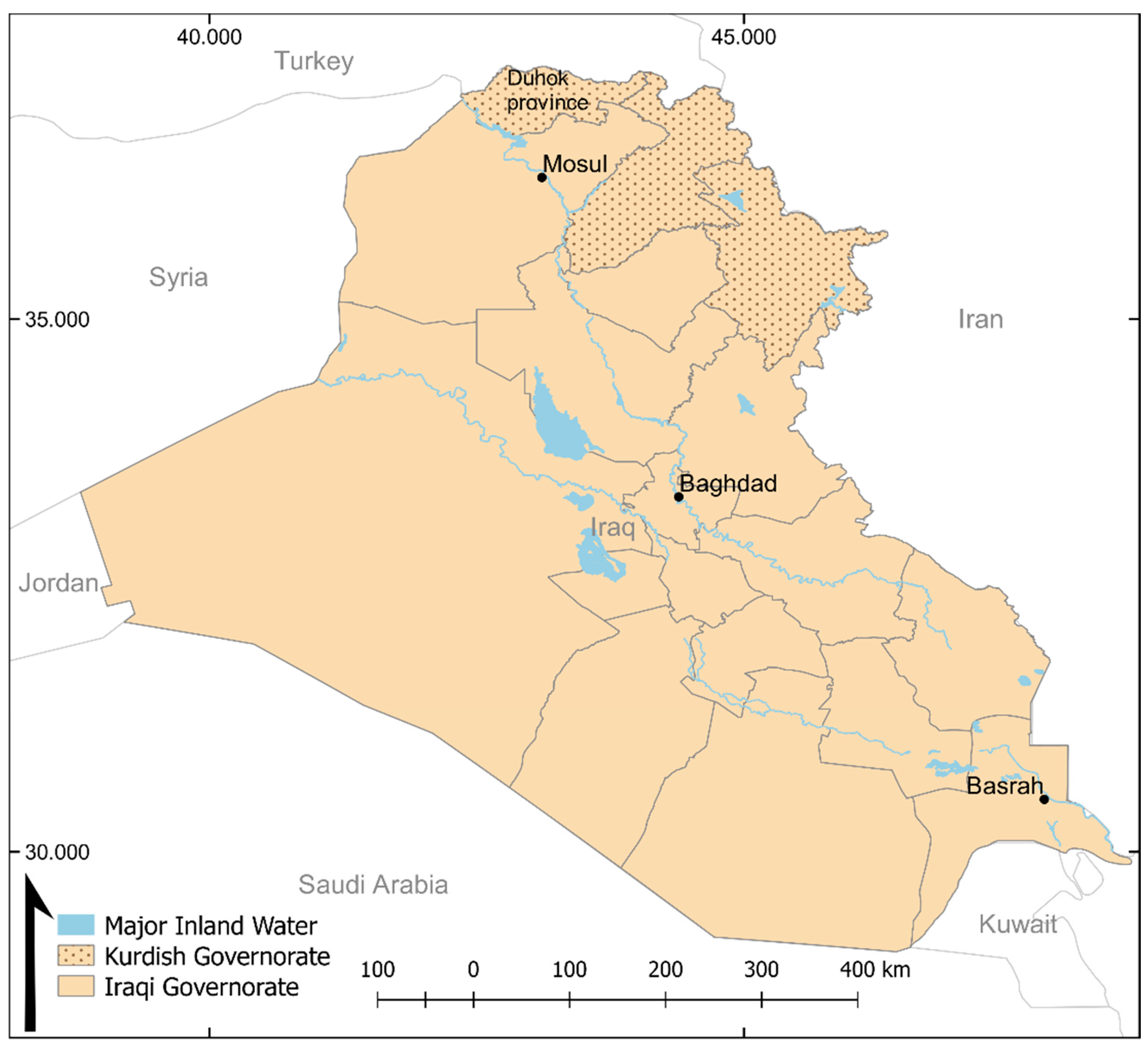
The KR-I covers an area of about 40,000 km2, which includes the three provinces of Duhok, Erbil, and Suleymania, where the city of Erbil is the capital and home to the KRG headquarters (Figure 1).

Figure 1.
Study area map showing Iraq, the location of Iraqi Kurdistan (including the Duhok governorate), and major rivers and lakes.
The KR-I borders Syria in the northwest, Turkey in the north, Iran in the northeast, and Iraq in the south (Figure 1). The area is home to three large dams, the Mosul dam, Dokan dam, and Darbandikhan dam. The northern parts of Kurdistan are mountainous areas, with peaks of up to 3600 m above mean sea level while the southern parts consist of plains suitable for grain production [16]. The climate of Kurdistan is governed by orographic precipitation from the mountains, leading to high precipitation rates in the northern parts, and drier climate in the plains [35]. Precipitation is concentrated from October to May, while the hotter summer months hold little or no precipitation at all. The average annual precipitation ranges between 300 and 1000 mm, with inter-annual variations of between 100 mm and 1300 mm [36,37,38]. The mean daily temperature for winter is around 5 °C and in summer the mean temperature is around 30 °C, but can rise to 50 °C in the southern parts [38].
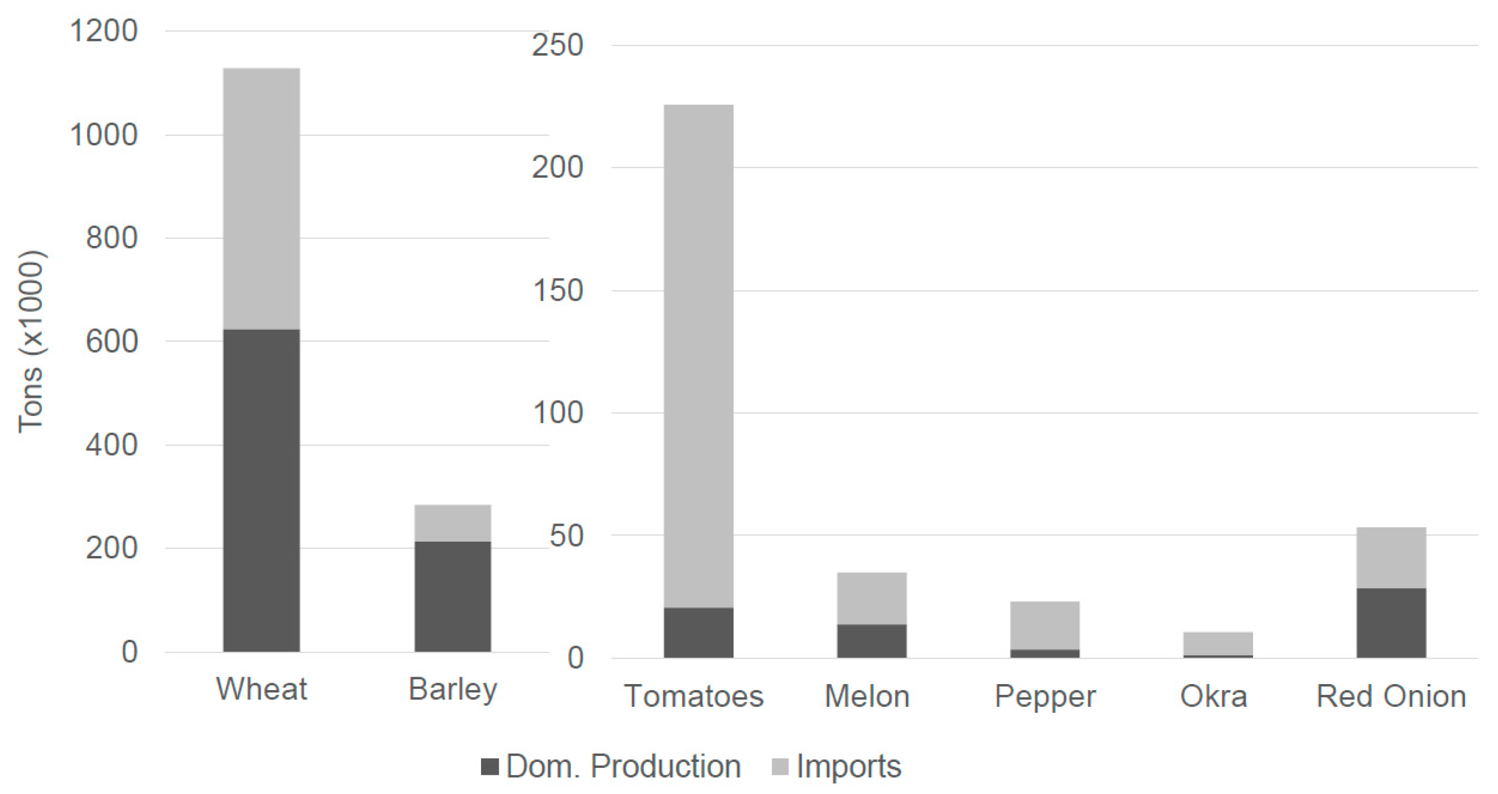
The most common crop dominating the landscape of Kurdistan is wheat, taking up about 16.5% of the total KR-I area in 2011 [39]. Barley is the second most common crop, with nearly 6% of the KR-I area allocated to its production. All other crops, vegetables, and pulses are substantially less extensive, with areas of between 0.1% and 0.2% of the total KR-I area. Figure 2 shows that the KRG was importing large shares of the vegetables consumed in the region in 2010. For wheat and barley, however, the domestic production was higher than the imports, although only slightly more wheat was produced domestically compared to the imported amount. These statistics suggest that the region is highly dependent on imports.
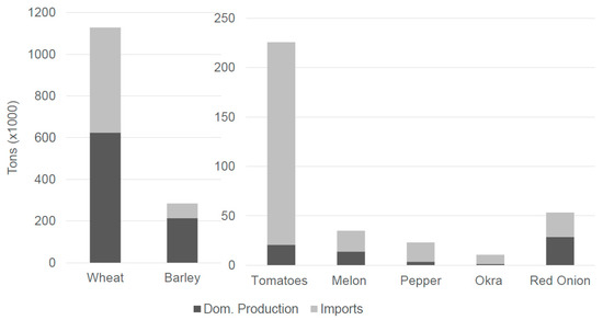
Figure 2.
Kurdistan Regional Government (KRG) domestic production and imports for 2010. Source: Kurdistan Region Statistics Office (KRSO) [39,40].
This study specifically focuses on the Duhok governorate, which is situated in the northwestern part of the KR-I (Figure 1). The Duhok governorate had a population of approximately 1.2 million people in 2009, of which 27% resided in Duhok City, the main urban center in the province [41]. The Duhok governorate has historically been a largely rural and agricultural area, but is now, like other parts of the KR-I, facing urban expansion and economic growth. This makes the area an interesting case study for understanding agricultural and rural development in the context of socio-economic and political changes.
2.2. Data and Methods
2.2.1. Biophysical Assessment
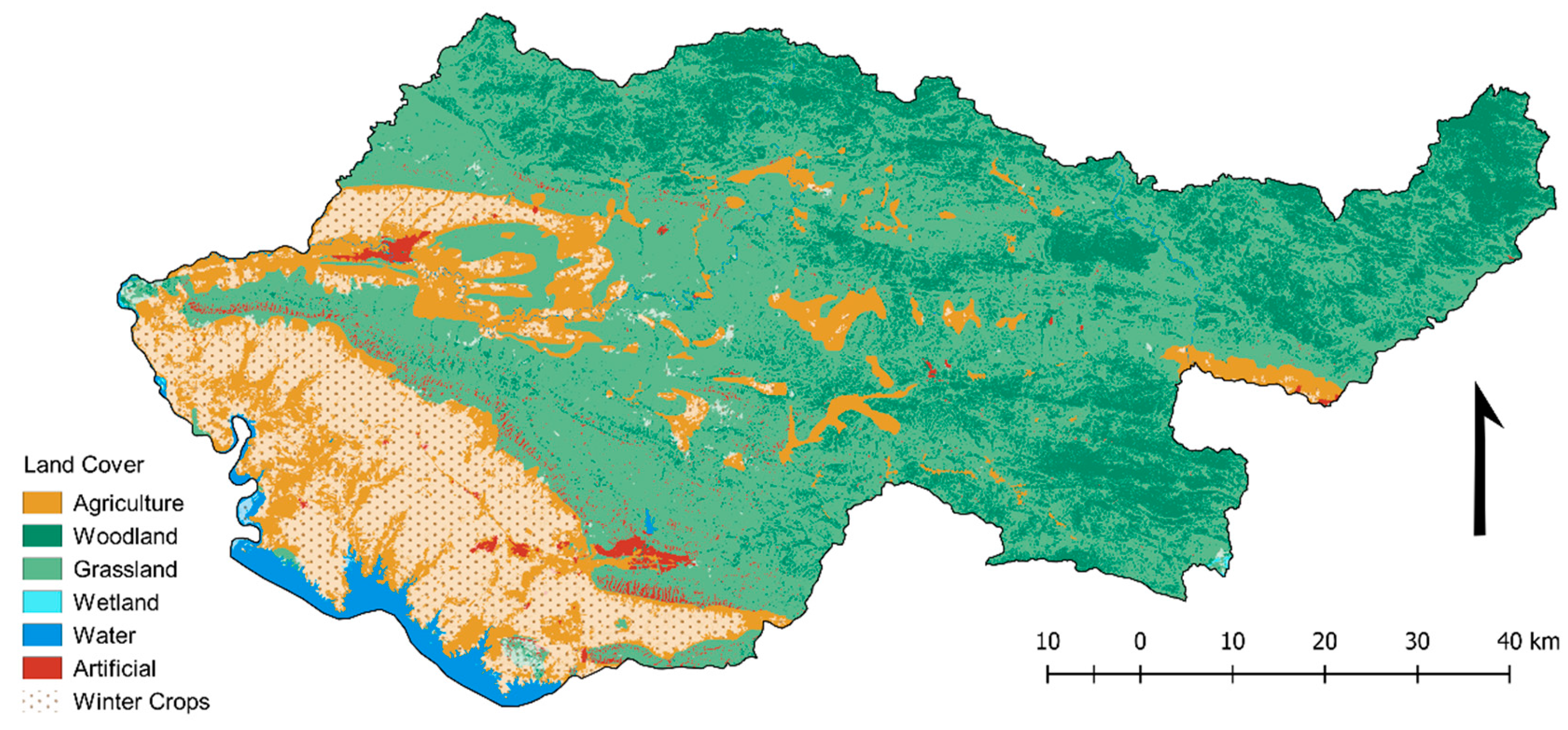
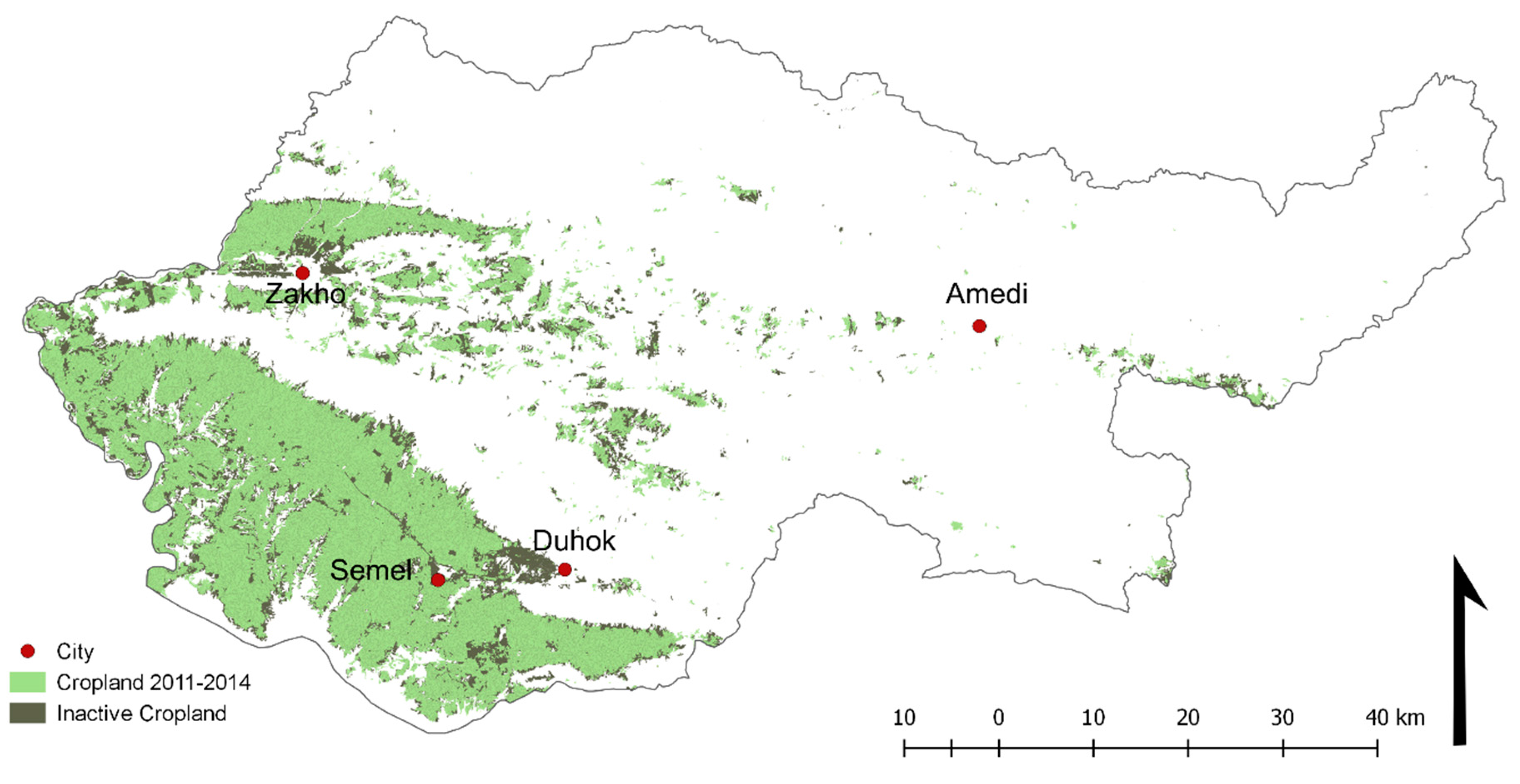
We used a dataset based on the classification of winter cropland (primarily cereals) using the difference between pre- and post-harvest vegetation greenness (represented by Normalized Difference Vegetation Index, NDVI) to identify differences in trends between croplands and other land uses. Winter cropland classification allows for the study of the dynamics between active and inactive croplands. We used the dataset to identify land that has been cultivated at least once between 1984 and 2014, hereafter referred to as “arable land”. We compared that extent to land that was cultivated between 2011 and 2014, and identified areas that could be reclaimed for agriculture. For the cropland productivity analysis, we used the areas that were classified as cropland during both periods 1998–2002 and 2011–2014 in the dataset (Figure 3). The Globeland30 land cover dataset [42] was used solely to visualize the other land cover classes in Duhok governorate (Figure 3).
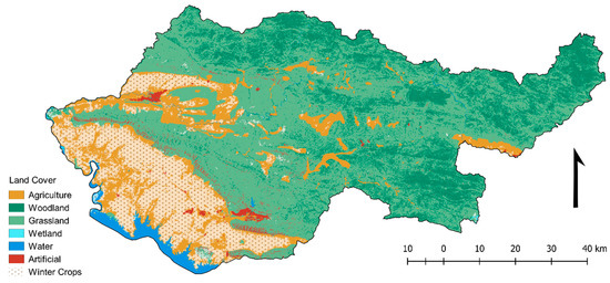
Figure 3.
Land cover in the Duhok governorate by 2010 based on Globeland30 (provided by National Geomatics Center of China, DOI:10.11769/GlobeLand30.2010.db). Winter crop areas for the period 1998–2014 are superimposed on the land cover classification.
Net photosynthesis is the amount of carbon that plants extract from the atmosphere and store as phytomass minus the carbon spent on maintenance respiration. Vegetation productivity can be measured using net photosynthesis, which has been proven to be positively correlated with agricultural yield [43]. Net photosynthesis was calculated every eight days over a 14-year time period (2000–2013) using the light use efficiency model as applied in the MOD17 product of the Moderate Resolution Imaging Spectroradiometer (MODIS) satellite sensor:
where PSN is the net photosynthesis of an ecosystem independent of land use; APAR is absorbed photosynthetically active radiation, which is a product of total incoming photosynthetically active radiation and its fraction absorbed by the vegetation canopy; εmax represents maximum light use efficiency under hypothetical biome specific ideal conditions; VPD and Tmin are vapor pressure deficit and minimum temperature, respectively, which reduce light use efficiency due to environmental conditions; Rm (maintenance respiration) represents the respiration of leaves and fine roots. Further descriptions of the MOD17 model are detailed in Zhao et al. [44] and the MOD17 product is available from the NASA Earth Observation System repository at the University of Montana (http://www.ntsg.umt.edu/project/mod17).
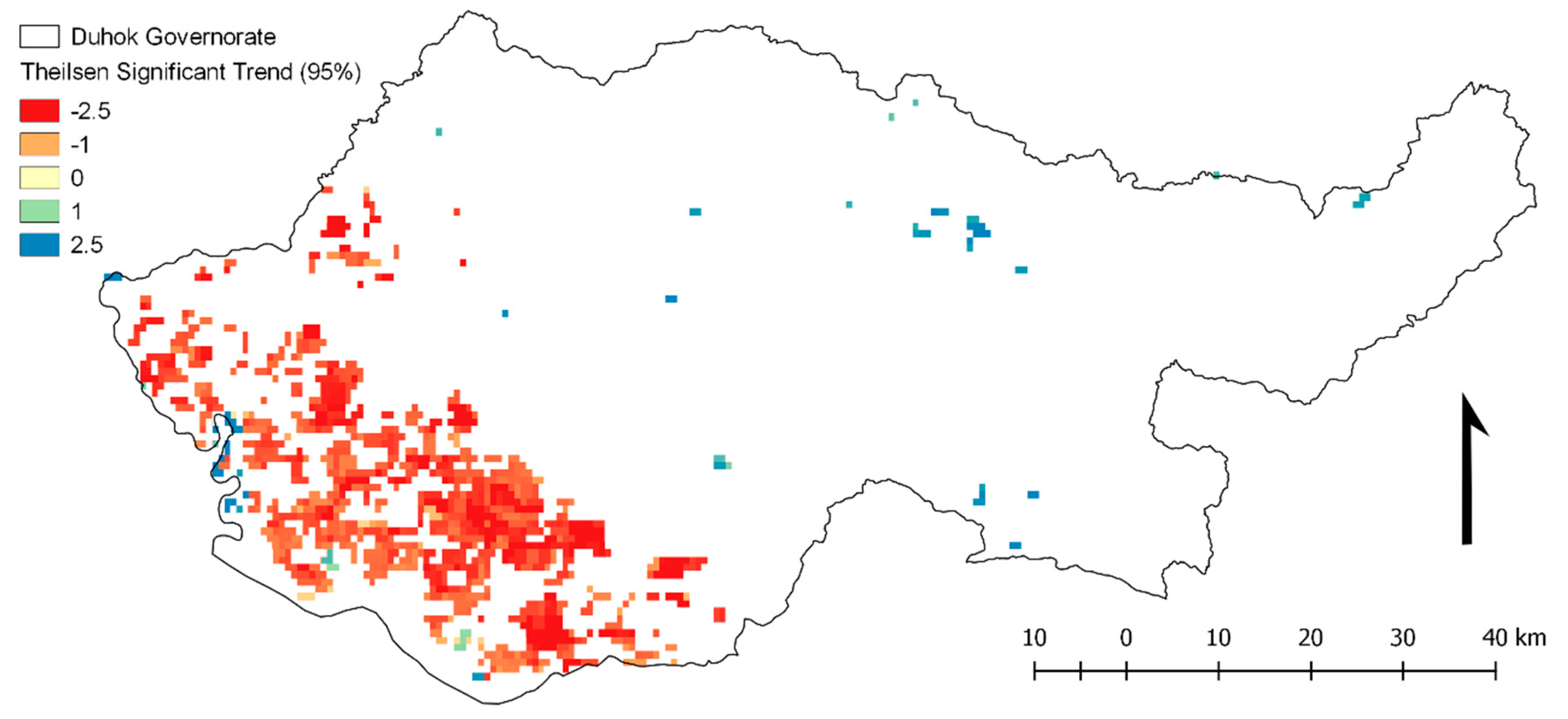
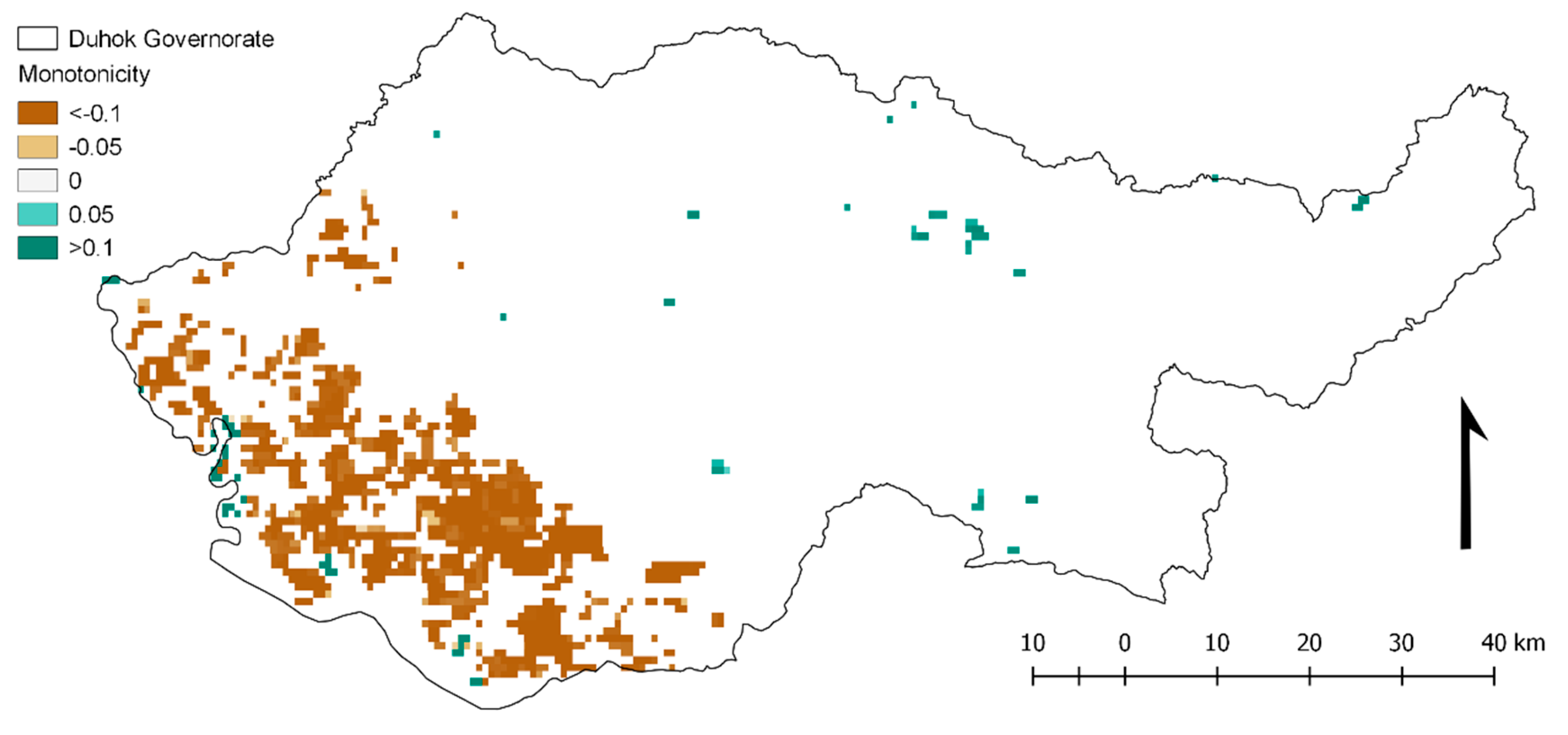
After the isolation of cropland and non-cropland areas, the growing season for each year in the 14-year time series was defined as spanning Day of Year (DOY) 65 (March 6) to DOY 177 (June 26) of the MODIS PSN time series, based on Eklund and Seaquist (2015) [35]. Then, a two-sided Mann-Kendall trend test was applied to the growing season data. The null hypothesis of the Mann-Kendall trend test is that the MODIS PSN data are independent and randomly ordered; the alternative hypothesis is that the data possesses a monotonic trend in one or more years. Monotonicity refers to the proportion of increases relative to decreases in time (and vice versa) considering all possible pairwise time differences. The output of the Mann-Kendall trend test statistic ranges from +1 to −1, depending on the strength of the monotonicity. The test statistic will be positive if the data values are increasing, and negative if they are decreasing. The closer the statistic is to ±1, the higher the monotonicity between the values. We applied the nonparametric Theil-Sen slope estimate to gauge the magnitude of the trend. Here, the null hypothesis is rejected if the test statistic is different from zero at the 5% significance level.
2.2.2. Socio-Economic and Political Assessment
To assess the socio-economic situation for agriculture, we follow a qualitative approach and apply policy analysis on two publications: (1) Regional Development Strategy for Kurdistan Region (KRG MoP, 2011); and (2) “Revitalising Agriculture and Water Sectors in the Kurdistan Region, Iraq”, authored by the former Minister of Agriculture and Water Resources [45]. Additionally, we conducted a series of household surveys in order to understand the pivotal role of politics and conflict in understanding the link between people and the land ([46], p. 17). Survey field work took place in April 2013 and included interviews in six villages with a total of 31 households (Table 1). The villages were chosen based on a previous survey that revealed an urban-to-rural migration trend and the selected villages had received the majority of this type of migration [47]. We used a systematic sampling approach by choosing the households in every third house on the left side of the main street. The semi-structured interviews were carried out in Kurdish (aided by a translator). The answers were written down in English and each interview took approximately 30 min. The questions were about migration trends, land tenure, and agriculture. To provide the anonymity of household identities, the villages were given codes instead of using their real names (Table 1). Villages 1 and 4 were located in the plains in the southern and southwestern parts of Duhok governorate. Villages 2 and 3 were located in the mountainous area in the northern part of the governorate, and villages 5 and 6 were located in the northwestern part, between two mountain ranges. The topography surrounding the villages influenced the suitability for certain types of agriculture. We used a thematic coding analysis technique manually administered to identify recurring patterns in the household interviews that were relevant for this study.

Table 1.
Summary of village interviews.
3. Results
3.1. Land Use and Vegetation Productivity Trends
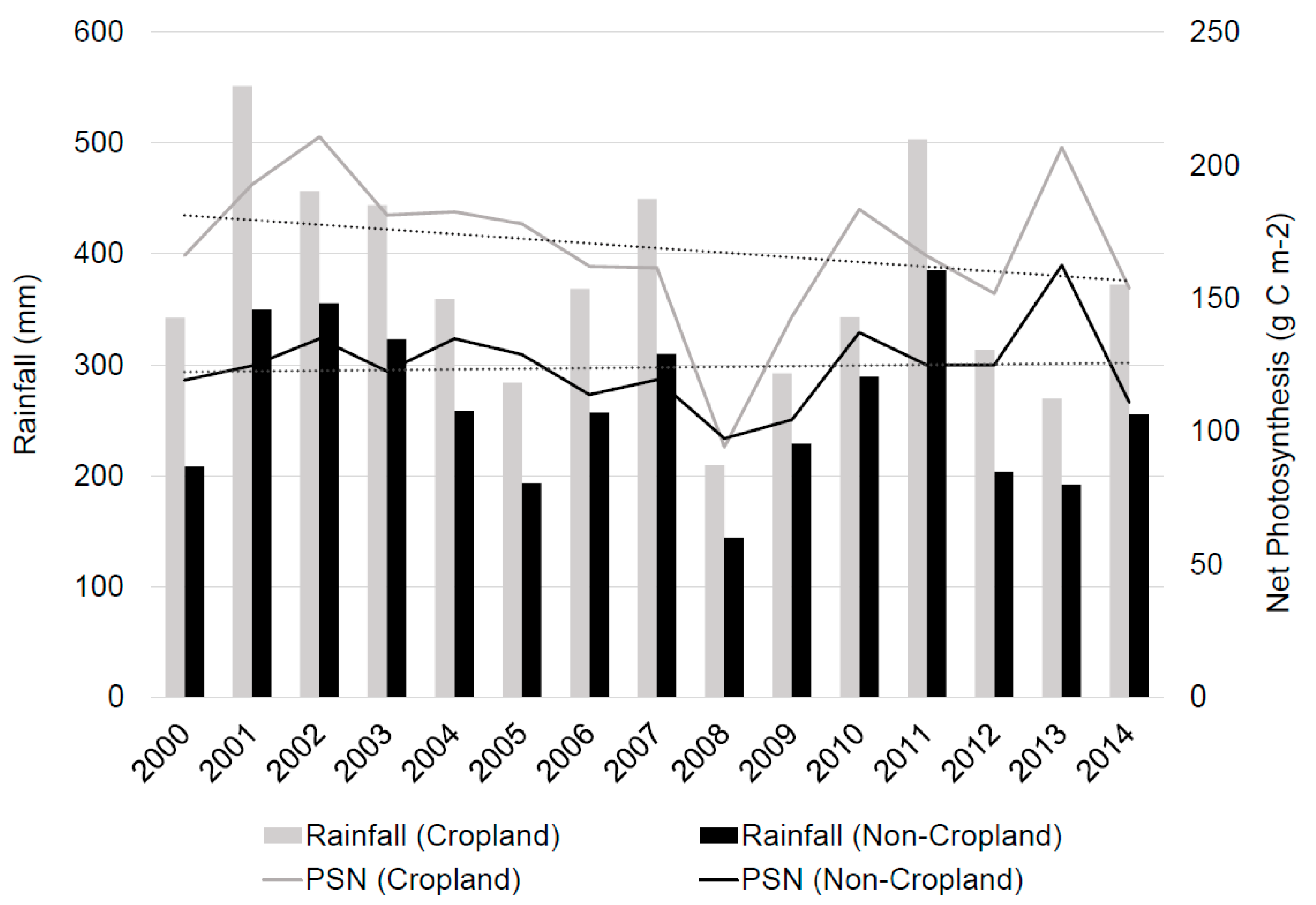
Areas defined as “arable land” amounted to 1550 km2, which represents 24% of Duhok governorate (Figure 4). Between 2011 and 2014, 1140 km2 of land were classified as active, leaving 410 km2 that had previously been used for cereal cultivation, but had changed land use or became fallow. Much of the fallow land is located around the urban areas of Duhok and Zakho, which suggests that these lands are part of an urban expansion process (Figure 4). A significant negative trend in vegetation productivity is evident in areas classified as winter cropland (Figure 5), indicating land degradation and reduction of productivity in these areas. A few areas exhibiting positive trends in vegetation productivity are found in mountainous areas where the dominant land cover is woodland and grassland. The monotonicity of the Mann-Kendall trend shows the extent to which the trend has been steadily decreasing (negative values) or increasing (positive values). The values in cropland areas show a moderate monotonicity, indicating that there are some fluctuations between different years, but that the overall trend in vegetation productivity is negative (Figure 6). Between 2000 and 2013 the average vegetation productivity fluctuated strongly in cropland areas and followed a similar temporal pattern as the precipitation (Figure 7). Croplands show an overall negative trend in productivity, while non-cropland areas show a stable trajectory. The drop in vegetation productivity in 2008 coincides with a documented meteorological drought [35], but non-cropland areas did not exhibit the same drastic change in productivity.

Figure 4.
Active and inactive (or converted) cropland in the period 2011–2014.
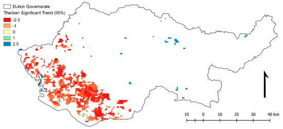
Figure 5.
Growing season productivity trend represented by the trend slope, i.e., the gain or loss of net photosynthesis (PSN, gCm−2) per year. Only statistically significant (p < 0.05) areas are shown.
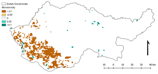
Figure 6.
Monotonicity of net photosynthesis in areas with significant trend (p < 0.05). Positive values indicate that the proportion of increases over time are higher relative to decreases. Higher values in either direction signify increasing (+) or decreasing (−) monotonicity.
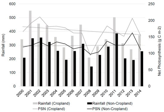
Figure 7.
Growing season net photosynthesis (PSN) and rainfall trends in cropland and non-cropland areas between 2000 and 2013.
3.2. Socio-Economic Potential and Challenges
Below are the results based on the policy analysis and qualitative interviews. These are emerging socio-economic issues that concern the future development of agriculture in Duhok governorate and the Kurdistan Region in general.
3.2.1. Policy Analysis
The main objective of the Ministry of Agriculture and Water Resources in the Kurdistan Region of Iraq is to “achieve food and water sufficiency and security” [45]. In order to reach this goal a road map has been developed, which is described by Baban [45], minister of Agriculture and Water Resources in the KR-I during 2012–2014. According to the Regional Development Strategy (RDS) report, a major obstacle for agricultural development is fragmented land [48]. Reduced areas of arable lands and inheritance-based land rights have led to the fragmentation of large agricultural lands into small and economically unfeasible units. This is considered an obstacle by the regional government, as private sector-led large-scale agricultural development is one of the goals of this development strategy. The RDS (2012) states that “considerable efforts should be made to expand the area of agricultural land through concentrating on reclamation on uncultivable land”, suggesting land extensification [49] as a strategy to meet the demands of the population.
In the Kurdistan region, agriculture and irrigation practices have been part of a political-administrative modernization strategy both before and after the Iraq war that began in 2003 [31]. The RDS report confirms this strategy, as private sector involvement, and utilization of modern technology and foreign expertise are listed as the mission of the regional government for agriculture development [48]. The RDS [48] also states that their goal is to increase the production rate of basic crops by 8% per year.
One of the short-term priorities listed by Baban [45] is to grant more support to “productive farmers” and link the support to the actual quality and quantity of agricultural produce. Providing a help package to farmers is presented as a long-term strategy that has been achieved already [45]. These packages include loans to farmers, improved seeds, fertilizers, farm equipment, transport subsidies, machinery, agricultural extension services, and animal fodder. Also, the revival of rural areas has been identified as a critical step to revitalize agriculture in the region. This includes providing suitable living environments in the villages in order to facilitate people returning to the land and local involvement in food production. So far this has not been addressed sufficiently by the government, and is presented as one of the challenges to implement the road map. The RDS [48] mentions this problem as well, emphasizing the shortage of services and infrastructure, and the general quality of life.
3.2.2. Local Perspectives on Agriculture and Rural Life
Three main themes emerged from the interview data; agricultural production and management of land, government support to rural areas, and urban-rural dynamics. These are described and discussed below.
A majority of the households (74%) in the surveyed villages were engaged in agriculture (Table 1). In villages 1, 4, and 5, households were engaged in grain production, mainly the production of wheat. In these villages, fallow practices involved either leaving half of the land fallow, or changing from wheat to melon every other year. In the other villages (2, 3, and 6), orchard agriculture was the dominant cultivation type. The villages involved in orchard agriculture generally irrigated their lands, but the grain production was mostly rain fed. Upon questioning, very few households responded that they intend to expand their agricultural production. Some would like to add some other types of trees to their orchards, and one household would like to switch to more income-yielding crops but stated that there was no support from the government to do so. When asked about the general agricultural situation in the village now compared to ten years ago, many respondents stated that technology has improved the situation for farmers, but that there was generally more rain ten years ago. One household states that it was much better ten years ago when the local production could compete better with the imports.
The general response of the interviewees to the question of government support was that they received none. However, when asked more specific questions some households reported that they receive pesticides and/or water tanks. In village 4, we did an interview with the village leader (mokhtar) who explained that it was his role to pass information from the local government onto the villagers. Despite this, only one household in that village reported receiving information from the government, e.g., about sowing and harvest.
Twenty-five out of 31 households had migrated to their current village in the past ten years (2003–2013). Most of these households moved from the cities Duhok or Zakho (both located inside the Duhok governorate), or from Baghdad. All but one of the households explained that they chose their respective village because they had family ties to the land. In a few of the interviews we discovered that the village in question had been destroyed during the 1970s by the Iraqi government, forcing people into urban areas and collective towns. A difficult housing situation in the city and the rebuilding of their old village were given as reasons for leaving Duhok and Zakho, while people leaving Baghdad generally did so for security reasons. When asked about the households’ plans to remain in their village, several households expressed a desire to move to Duhok or Zakho to get better access to health care and education facilities, and a higher standard of living in general.
4. Discussion
4.1. Productivity Decline
The biophysical assessment of Duhok governorate indicates that yields have been decreasing due to a decline in the productivity of winter cropland areas. The situation was more stable in the non-cropland areas, where some areas had positive trends in vegetation productivity. The disparity in productivity between cropland and non-cropland areas highlights the need for more attention to the land management practices in cropland areas. These findings are contradictory to the report from the Ministry of Agriculture and Water Resources, who documented an overall yield increase in wheat in the Duhok governorate [39]. The RDS, on the other hand, found that wheat yields decreased from 1203 kg/ha to 1180 kg/ha between 2003 and 2006 [48], while our assessment for this period shows a steady decline. Here, remote sensing can be a good complement for government assessments of productivity and agricultural land use.
In the context of declining vegetation productivity, the socio-economic assessment of potential development of agriculture in the Duhok governorate attempts to provide insights about land management practices. Our assessment showed that government policies support agricultural development, while in practice there are several structural challenges. The RDS [48] stated increasing productivity as one of their goals, but no explanations for how this should be done were provided. Baban [45] also highlighted the need for increasing productivity and presents both long-term and short-term strategies. A short-term strategy is to provide more support to productive farmers, while a long-term strategy is to provide help packages to farmers in general. While this latter strategy has been implemented, few of the households interviewed for this study acknowledged support from the government, and the biophysical assessment indicates that it has not been successful in improving land productivity.
4.2. Land Extensification
The RDS [48] presented fragmented lands as a challenge and emphasizes increasing the cultivated area as a way to increase the agricultural production in the region. The interviews revealed that there was very little incentive among farmers to expand their area under cultivation. Furthermore, our biophysical assessment shows that there is not much land available for extensification in areas which have previously been cultivated. Instead, a land extensification would need to happen on previously uncultivated land, which may not be suitable for large-scale cultivation. Land extensification is also considered problematic, as it occurs at the expense of other land use and cover types, such as forests or natural areas, thereby having impacts on ecosystem services, biodiversity, and the carbon budget [50,51,52]. If the lands to be reclaimed for agriculture are unsuitable for that purpose, the extensification may also lead to water- and input-intensive agriculture, putting even more pressure on water and land resources [53]. Furthermore, increasing production by increasing the area under cultivation has been associated with poor governance [50].
4.3. The Rural-Urban Dilemma
According to the Regional Development Strategy for Kurdistan region, agriculture was the source of livelihood for 35% of the region's population in 2000 [48]. However, this number declined to 23% in 2007. A study of migration and livelihoods in the Duhok governorate from 2011 showed that only 20% of the surveyed rural households drew an income from agriculture, and only 11% had agriculture as their only income (Eklund and Pilesjö [47]). In the six villages, almost 75% of the interviewed households were engaged in agriculture, but not all were producing for commercial purposes.
Increasing unemployment rates in rural areas as well as deteriorating land resources are often considered to be reasons why more people migrate to urban areas [48]. The findings of Eklund and Pilesjö [47], however, showed an opposite migration trend. An interesting pattern among the responses emerged when investigating the urban-rural migration detected by Eklund and Pilesjö [47], showing that many of the households who had left an urban area to live in their family village were eager to move back to the cities. Lack of housing in the cities of Duhok and Zakho pushed people to migrate to the rural areas, but lack of health care and educational facilities are pushing them back to urban areas. This is a finding that requires the government’s attention if they want to ensure that people stay in rural areas and continue developing the agricultural sector for food self-sufficiency. Both Baban [45] and RDS [48] acknowledge the lack of infrastructure in rural areas, but so far very little has been done. Furthermore, the interviews reflect a difficult situation in urban areas where housing has become too expensive for some people. The urban-rural migration pattern thus partly reflects a counter-effect of the rural-urban migration and urbanization trend that has been witnessed in the main cities of Iraqi Kurdistan [54].
4.4. Political Conflict and Mobility
The current conflict and instability in the neighboring areas of Iraq, Syria, and Turkey can potentially threaten the stability of the rural areas and thus the agricultural production in the Duhok governorate. Eklund and Pilesjö [47] found that the population of the Duhok governorate are highly mobile and have a history of migration when the security situation gets acute. This might have a negative impact on the future of sustainable agriculture and land use, as the relation between farmers and land is constantly interrupted.
5. Conclusions
The results of this study show the agricultural situation in Iraqi Kurdistan from three perspectives, the biophysical, the political, and the socio-economic. We identify several challenges for the region that relate to these three perspectives. First of all, the land is becoming less productive. In order to combat this degradation of land we need to identify the specific causes of it, and further investigate how land and water resources are managed and the policies around that. Another aspect is that small-scale agriculture is becoming a less desired way of life. Many of the rural residents would prefer an urban lifestyle with improved services and access.
If the KRG want to increase the region’s agricultural production and attain food self-sufficiency with support from the local population, more resources need to be focused on improving rural infrastructure and services to increase access to education and health care. Furthermore, they need to consider whether land extensification is possible, as our study shows clear limitations to that.
We also find that the KRG is interested in developing large-scale agriculture in the Kurdistan region. Their strategy for agricultural development is listed as private sector involvement, and utilization of modern technology and foreign expertise. Although agribusiness’ large farms can be a solution to reduce unemployment and improve technology, they have serious implications on the environment as well as on the social fabric, as they often replace smaller farms. Our findings highlight that locals have strong ties to their lands and traditional agricultural practices are still prevalent. In this context, supporting small-scale traditional agriculture development might be more sustainable and feasible.
Practices of small-scale agriculture in self-rule communities can serve as an alternative model to top-down large-scale agriculture as aspired by the KRG. In order to overcome the current and future problems of food scarcity, communities, like Rojava in Syrian Kurdistan, have started their own agricultural plan based on permaculture farming and participatory principles (see Cemgil [55]). Agro-collectives in Rojava are seen as a core local institution which aims to provide social equality by putting limits on the market economy [56]. In this context, it is important to pay attention to different class-based structures, which might enable or disable these community-based initiatives especially in conflict geographies like Iraqi Kurdistan.
Based upon the results of this study, we suggest that policy makers:
- Identify the reasons behind the land degradation trend, by looking over irrigation systems and other practices of land management, to come up with a strategy to combat land degradation.
- Improve infrastructure and services in rural areas in order to facilitate a rural lifestyle and support traditional food production.
- Develop a land use plan that considers the need for arable land and makes sure that land use changes, such as urban expansion, are done in a sustainable manner.
This study highlights the added value of an assessment that includes multiple perspectives on agricultural and rural development. By using a mixed methodology, we can better understand whether the government plans align with the rural population’s perspectives and the biophysical availability, or productivity, of land. A further development of this research would include a more thorough biophysical assessment of land degradation and land use to identify needs for improvement in management and policies. Furthermore, an in-depth analysis of migration patterns and rural development, through, for example, studies of accessibility, would provide information about where resources are needed to improve rural development.
Acknowledgments
This research was supported through a grant from the Lund University Centre of Excellence for Integration of Social and Natural Dimensions of Sustainability (LUCID). L.E. is supported by the Middle East in the Contemporary World (MECW) project funded by the Swedish Research Council. The survey data collection in Kurdistan was supported by the Swedish Society for Anthropology and Geography (SSAG). The authors thank Shawkat Mohammad for helping during the field work and Darcy Thompson and Jonathan Seaquist for helpful comments on the manuscript.
Author Contributions
Lina Eklund and Mine Islar developed the initial idea for the research; Lina Eklund and Mine Islar designed the surveys, and Lina Eklund conducted the interview fieldwork; Abdulhakim Abdi and Lina Eklund performed the biophysical assessment; Mine Islar and Lina Eklund carried out the socio-economic and political assessment. Lina Eklund led the writing of the paper and wrote it together with Abdulhakim Abdi and Mine Islar.
Conflicts of Interest
The authors declare no conflict of interest.
References
- Ramankutty, N.; Evan, A.T.; Monfreda, C.; Foley, J.A. Farming the planet: 1. Geographic distribution of global agricultural lands in the year 2000. Glob. Biogeochem. Cycles 2008, 22, GB1003. [Google Scholar] [CrossRef]
- Fuglie, K.O. Productivity growth and technology capital in the global agricultural economy. In Productivity Growth in Agriculture: An International Perspective; Fuglie, K.O., Wang, S.L., Ball, V.E., Eds.; CAB International: Wallingford, UK, 2012; pp. 335–357. [Google Scholar]
- FAO; IFAD; WFP. The State of Food Insecurity in the World; Food and Agriculture Organization of the United Nations: Rome, Italy, 2015. [Google Scholar]
- Chavas, J.-P.; Hummels, D.; Wright, B.D. The Economics of Food Price Volatility; University of Chicago Press: Chicago, IL, USA, 2014. [Google Scholar]
- Millennium Ecosystem Assessment. Ecosystems and Human Well-Being; Island Press: Washington, DC, USA, 2005. [Google Scholar]
- Pretty, J.; Sutherland, W.J.; Ashby, J.; Auburn, J.; Baulcombe, D.; Bell, M.; Bentley, J.; Bickersteth, S.; Brown, K.; Burke, J.; et al. The top 100 questions of importance to the future of global agriculture. Int. J. Agric. Sustain. 2010, 8, 219–236. [Google Scholar] [CrossRef]
- Baumann, M.; Kuemmerle, T.; Elbakidze, M.; Ozdogan, M.; Radeloff, V.C.; Keuler, N.S.; Prishchepov, A.V.; Kruhlov, I.; Hostert, P. Patterns and drivers of post-socialist farmland abandonment in Western Ukraine. Land Use Policy 2011, 28, 552–562. [Google Scholar] [CrossRef]
- Baumann, M.; Ozdogan, M.; Kuemmerle, T.; Wendland, K.J.; Esipova, E.; Radeloff, V.C. Using the Landsat record to detect forest-cover changes during and after the collapse of the Soviet Union in the temperate zone of European Russia. Remote Sens. Environ. 2012, 124, 174–184. [Google Scholar] [CrossRef]
- Hostert, P.; Kuemmerle, T.; Prishchepov, A.; Sieber, A.; Lambin, E.F.; Radeloff, V.C. Rapid land use change after socio-economic disturbances: The collapse of the Soviet Union versus Chernobyl. Environ. Res. Lett. 2011, 6, 045201. [Google Scholar] [CrossRef]
- Kuemmerle, T.; Müller, D.; Griffiths, P.; Rusu, M. Land use change in Southern Romania after the collapse of socialism. Reg. Environ. Chang. 2009, 9, 1–12. [Google Scholar] [CrossRef]
- Prishchepov, A.V.; Radeloff, V.C.; Baumann, M.; Kuemmerle, T.; Müller, D. Effects of institutional changes on land use: Agricultural land abandonment during the transition from state-command to market-driven economies in post-Soviet Eastern Europe. Environ. Res. Lett. 2012, 7, 024021. [Google Scholar] [CrossRef]
- Dadi, D.; Azadi, H.; Senbeta, F.; Abebe, K.; Taheri, F.; Stellmacher, T. Urban sprawl and its impacts on land use change in Central Ethiopia. Urban For. Urban Green. 2016, 16, 132–141. [Google Scholar] [CrossRef]
- Baumann, M.; Kuemmerle, T. The impacts of warfare and armed conflict on land systems. J. Land Use Sci. 2016, 11, 672–688. [Google Scholar] [CrossRef]
- Baumann, M.; Radeloff, V.C.; Avedian, V.; Kuemmerle, T. Land-use change in the Caucasus during and after the Nagorno-Karabakh conflict. Reg. Environ. Chang. 2014, 15, 1703–1716. [Google Scholar] [CrossRef]
- Eklund, L.; Degerald, M.; Brandt, M.; Prishchepov, A.V.; Pilesjö, P. How conflict affects land use: Agricultural activity in areas seized by the Islamic State. Environ. Res. Lett. 2017, 12, 054004. [Google Scholar] [CrossRef]
- Eklund, L.; Persson, A.; Pilesjö, P. Cropland changes in times of conflict, reconstruction, and economic development in Iraqi Kurdistan. Ambio 2015, 45, 78–88. [Google Scholar] [CrossRef] [PubMed]
- Hanh, H.Q.; Azadi, H.; Dogot, T.; Ton, V.D.; Lebailly, P. Dynamics of Agrarian Systems and Land Use Change in North Vietnam. Land Degrad. Dev. 2017, 28, 799–810. [Google Scholar] [CrossRef]
- Liu, Y.S.; Wang, J.Y.; Long, H.L. Analysis of arable land loss and its impact on rural sustainability in Southern Jiangsu Province of China. J. Environ. Manag. 2010, 91, 646–653. [Google Scholar] [CrossRef] [PubMed]
- Kamrava, M.; Babar, Z.; Woertz, E.; Harrigan, J.; Bush, R.; Salami, H.; Mohtashami, T.; Naeini, M.S.N.; Mundy, M.; Al-Hakimi, A. Food Security and Food Sovereignty in the Middle East. Available online: https://papers.ssrn.com/sol3/papers.cfm?abstract_id=2839219 (accessed on 28 April 2017).
- Ramankutty, N.; Foley, J.A.; Olejniczak, N.J. People on the Land: Changes in Global Population and Croplands during the 20th Century. AMBIO J. Hum. Environ. 2002, 31, 251–257. [Google Scholar] [CrossRef]
- Lal, R. Land Degradation and Its Impact on Food and Other Resources; Academic Press: San Diego, CA, USA, 1989; Volume 85. [Google Scholar]
- Kurdistan Regional Government (KRG). About Kurdistan Region: Contemporary History; Kurdistan Regional Government: Erbil, Iraq, 2010.
- Hardi, C. Gendered Experiences of Genocide: Anfal Survivors in Kurdistan-Iraq; Ashgate Publishing Company: Aldershot, UK, 2011. [Google Scholar]
- Barwari, N. Rebuilding peace: Land and water management in the Kurdistan Region of northern Iraq. In Land and Post-Conflict Peacebuilding; Unruh, J., Williams, R.C., Eds.; Routledge: Abingdon-on-Thames, UK, 2013. [Google Scholar]
- Schnepf, R. Iraq Agriculture and Food Supply: Background and Issues; CRS: Washington, DC, USA, 2004. [Google Scholar]
- Gibson, G.R.; Campbell, J.B.; Wynne, R.H. Three decades of war and food insecurity in Iraq. Photogramm. Eng. Remote Sens. 2012, 78, 885–895. [Google Scholar] [CrossRef]
- Human Rights Watch. Genocide in Iraq—The Anfal Campaign Against the Kurds; Human Rights Watch: New York, NY, USA, 1993. [Google Scholar]
- World Food Program (WFP). Comprehensive food Security & Vulnerability Analysis (CFSVA) Iraq; World Food Program: Erbil, Iraq, 2008. [Google Scholar]
- Meyer, J.A.; Califano, M.G. Good Intentions Corrupted: The Oil-for-Food Program and the Threat to the U.N., 1st ed.; Public Affairs: New York, NY, USA, 2006. [Google Scholar]
- WFP Iraq—North Coordination Office. "Oil For Food"—Food Basket Adequacy Assessment Survey (Draft); WFP: Erbil, Iraq, 2001. [Google Scholar]
- Söylemez, E. An Analysis of Kurdistan Regional Government’s Economic Policy Between 2003–2013. Available online: http://www.academia.edu/12475597/An_Analysis_of_Kurdistan_Regional_Government_s_Economic_olicy_Between_2003_-_2013 (accessed on 28 April 2017).
- Khalil, L. Stability in Iraqi Kurdistan: Reality or Image? Ekurd: Erbil, Iraq, 2009. [Google Scholar]
- Leezenberg, M. Urbanization, Privatization, and Patronage: The Political Economy of Iraqi Kurdistan; Saqi: Lodon, UK, 2006. [Google Scholar]
- Baban, S. Agriculture and the Road Map to Self-Sufficiency in Kurdistan. In Proceedings of the World Kurdish Congress 2012, Erbil, Iraq, 11–15 October 2012. [Google Scholar]
- Eklund, L.; Seaquist, J. Meteorological, agricultural and socioeconomic drought in the Duhok Governorate, Iraqi Kurdistan. Nat. Hazards 2015, 76, 421–441. [Google Scholar] [CrossRef]
- Held, C.C.; Cotter, J.V. Middle East Patterns, 4th ed.; Westview Press: Boulder, CO, USA, 2006. [Google Scholar]
- UNDP. Drought—Impact Assessment, Recovery and Mitigation Framework and Regional Project Design in Kurdistan Region (KR); UNDP: New York, NY, USA, 2010. [Google Scholar]
- Hijmans, R.J.; Cameron, S.; Parra, J.; Jones, P.; Jarvis, A.; Richardson, K. Worldclim—Global Climate Data. Available online: http://www.worldclim.org/ (accessed on 28 April 2017).
- Kurdistan Region Statistics Office (KRSO). Agricultural Areas in the Governorates Of Kurdistan Region; Kurdistan Region Statistics Office: Erbil, Iraq, 2012.
- Elam, T.M. IRAQ and KRG Wheat and Barley (2011). Kurdistan: Food Security, Food Safety, Agriculture, Water, Livestock. Available online: www.kurdistanfoodsecurity.com (accessed on 28 April 2017).
- Kurdistan Region Statistics Office (KRSO). Population 1977–2013; Kurdistan Region Statistics Office: Erbil, Iraq, 2014.
- Chen, J.; Chen, J.; Gong, P.; Liao, A.; He, C. Higher resolution GLC mapping. Geomat. World 2011, 4, 12–14. [Google Scholar]
- Zelitch, I. The Close Relationship between Net Photosynthesis and Crop Yield. BioScience 1982, 32, 796–802. [Google Scholar] [CrossRef]
- Zhao, Y.; Wei, F.; Yang, H.; Jiang, Y. Discussion on Using Antecedent Precipitation Index to Supplement Relative Soil Moisture Data Series. In Proceedings of the 3rd International Conference on Environmental Science and Information Application Technology, Beijing, China, 18–19 June 2011; Procedia Environmental Sciences: Beijing, China; pp. 1489–1495. [Google Scholar]
- Baban, S. Revitalising Agriculture and Water Sectors in the Kurdistan Region, Iraq. In Proceedings of the ATINER’S Conference Paper Series, Athens, Greece, 1–4 June 2015. [Google Scholar]
- Blaikie, P.; Brookfield, H. Land Degradation and Society; Methuen: Lodon, UK, 1987. [Google Scholar]
- Eklund, L.; Pilesjö, P. Migration Patterns in Duhok Governorate, Iraq, 2000–2010. Open Geogr. 2012, 5, 48–58. [Google Scholar] [CrossRef]
- KRG MoP. Regional Development Strategy for Kurdistan Region 2012–2016; KRG MoP: Erbil, Iraq, 2011.
- Bilsborrow, R.E.; Ogendo, H. Population-driven changes in land use in developing countries. Ambio 1992, 21, 37–45. [Google Scholar]
- Mandemaker, M.; Bakker, M.; Stoorvogel, J. The role of governance in agricultural expansion and intensification: A global study of arable agriculture. Ecol. Soc. 2011, 16, 8. [Google Scholar] [CrossRef]
- Kalnay, E.; Cai, M. Impact of urbanization and land-use change on climate. Nature 2003, 423, 528–531. [Google Scholar] [CrossRef] [PubMed]
- Daily, G.C.; Söderqvist, T.; Aniyar, S.; Arrow, K.; Dasgupta, P.; Ehrlich, P.R.; Folke, C.; Jansson, A.; Jansson, B.-O.; Kautsky, N.; et al. The Value of Nature and the Nature of Value. Science 2000, 289, 395–396. [Google Scholar] [CrossRef] [PubMed]
- Lal, R. Laws of sustainable soil management. In Sustainable Agriculture; Springer: Dordrecht, The Netherlands, 2009; pp. 9–12. [Google Scholar]
- Silva, A. Geopolitics of Urbanisation in Kurdistan; Abitare: Milan, Italy, 2010. [Google Scholar]
- Cemgil, C. The republican ideal of freedom as non-domination and the Rojava experiment ‘States as they are’ or a new socio-political imagination? Philos. Soc. Crit. 2016, 42, 419–428. [Google Scholar] [CrossRef]
- Küçük, B.; Özselçuk, C. The Rojava Experience: Possibilities and Challenges of Building a Democratic Life. South Atl. Q. 2016, 115, 184–196. [Google Scholar] [CrossRef]
© 2017 by the authors. Licensee MDPI, Basel, Switzerland. This article is an open access article distributed under the terms and conditions of the Creative Commons Attribution (CC BY) license (http://creativecommons.org/licenses/by/4.0/).