Article

Forest Transition in Madagascar’s Highlands: Initial Evidence and Implications

1
Center for Global Change and Earth Observations, Michigan State University, East Lansing, MI 48823, USA
2
Center for Systems Integration and Sustainability, Michigan State University, East Lansing, MI 48823, USA
3
Department of Geography, University of North Carolina, Chapel Hill, NC 27599, USA
4
Institut de Géographie et Durabilité, Université de Lausanne, 1015 Lausanne, Switzerland
5
Department of Anthropology, Michigan State University, East Lansing, MI 48823, USA
*
Author to whom correspondence should be addressed.
Land 2015, 4(4), 1155-1181; https://doi.org/10.3390/land4041155
Submission received: 2 August 2015 / Revised: 26 October 2015 / Accepted: 9 November 2015 / Published: 25 November 2015
(This article belongs to the Special Issue Changing Land Use, Changing Livelihoods)

Abstract

:
Madagascar is renowned for the loss of the forested habitat of lemurs and other species endemic to the island. Less well known is that in the highlands, a region often described as an environmental “basket-case” of fire-degraded, eroded grasslands, woody cover has been increasing for decades. Using information derived from publically available high- and medium-resolution satellites, this study characterizes tree cover dynamics in the highlands of Madagascar over the past two decades. Our results reveal heterogeneous patterns of increased tree cover on smallholder farms and village lands, spurred by a mix of endogenous and exogenous forces. The new trees play important roles in rural livelihoods, providing renewable supplies of firewood, charcoal, timber and other products and services, as well as defensible claims to land tenure in the context of a decline in the use of hillside commons for grazing. This study documents this nascent forest transition through Land Change Science techniques, and provides a prologue to political ecological analysis by setting these changes in their social and environmental context and interrogating the costs and benefits of the shift in rural livelihood strategies.

1. Introduction

Madagascar is still losing its natural forest cover, despite decades of conservation efforts [1]. Many temperate countries and a few tropical countries have undergone a “forest transition,” whereby net deforestation is reversed, but Madagascar as a whole does not yet fit this pattern [2]. However, at the regional scale, the island nation exhibits large pockets where tree cover is expanding. In the highlands, for instance, which a century ago were largely grasslands devoid of tree cover, introduced eucalypts, pines, acacias, and diverse fruit trees have become ubiquitous.
While widespread and seemingly driven by rural people together with state foresters, this phenomenon presents several challenges for researchers and environmental managers. For one, methodologically, it has been difficult to map and quantify these tree cover dynamics. Traditional remote sensing techniques struggle with these sparse land covers, which are also very patchy and distributed across a landscape mosaic (unlike large blocks of closed canopy forest). Second, such tree cover—largely dominated by exotic species—is often ignored by conservationists for its lesser biological value, yet it turns out to be central to livelihoods and rural development, as well as being relevant to soil and water conservation, carbon budgets, invasion biology, and other aspects of environmental management.
In this paper, we seek to determine the degree to which the highlands of Madagascar are experiencing a sub-national forest transition, and to identify the causes and livelihood consequences of changes in tree cover in a region widely regarded as the scene of ecological and economic devastation. The specific objectives of the study were to document the dynamics of low-density woody cover in the highlands region, and to explain these dynamics and their livelihood implications. We use a simple, two-step mixed Land Change Science – Political Ecology approach [3], in which we first characterize the nature of tree cover change using remote sensing, and then subsequently paint a picture of the diverse factors—livelihood strategies, forestry and land tenure policies, struggles for resource control, ideas about proper environmental management, and plant invasiveness—that combine to cause these changes. More specifically, we applied novel remote sensing techniques involving “continuous” measures of tree cover at the pixel level, rather than delimiting strict forest cover categories. This allows us to characterize the extent and dynamics of low-density woody vegetation in the highlands over the past two decades. We then explain these changes, situating them in the context of land use and livelihoods in the highlands, setting the stage for further political ecological investigation. This study seeks to contribute to the rapidly maturing theoretical literature on the forest transition, which is briefly reviewed below, before an exposition of the novel remote sensing methods we bring to bear on the debate over forest change in Madagascar.

1.1. Theoretical Motivations

The realization that large parts of the world had undergone net increases in forest cover during the 20th Century has sparked one of the most important lines of inquiry in human-environment research over the past ten years, owing in part to growing interest in questions of carbon sequestration and other ecosystem services. The process of slowing deforestation and a subsequent shift towards net forestation in Western Europe and eastern North America as those economies shifted from agricultural to industrial bases has been coined the “forest transition” [4,5]. Detection of similar phenomena in East and South Asian countries [6,7] has fueled interest in the possibility that this phenomenon might be reproduced elsewhere—particularly in the tropics where deforestation continues to be a dominant and still growing trend [8]. This has become one of the most promising avenues for theoretical advancement in the emerging science of land change [9,10,11,12].
It was initially theorized that forest transitions mark the end of the process of clearing forest land to make way for agriculture. According to this explanation, industrialization leads to the concentration of population in urban centers, and consequent rural depopulation, spurring a spatial contraction of increasingly intensive agricultural production. It also leads to levels of affluence at which forests are increasingly valued for aesthetic purposes [4,5]. Cross-national analyses have provided some support for this explanation, but have also suggested a second—so-called “forest-scarcity”—path to the forest transition in developing countries, i.e., the planting of trees in response to perceived shortage of forest products [13].
The development of forest plantations around town centers has been a central tenet of land-use theory since its inception; von Thünen [14] theorized the development of a zone of tree production in proximity to towns, just outside a more proximate zone dedicated to the production of perishable products. Initial attempts have been made to link the von Thünen model with forest transition theory under idealized conditions [15], but a great need exists for empirical examination of the actual patterns and processes of the suggested “forest scarcity” pathway [13].
As it begins to mature, forest transition theory has attracted critical review on several counts. In terms of establishing the facts of forest cover change, there is concern that the “dependent variable”—spatio-temporal forest cover patterns—requires more systematic treatment. Generally, the procedures used to assess forest dynamics from remote sensing at global and continental scales suffer from lack of standardization, sometimes failing to differentiate natural forest from exotic monoculture plantations [16]. This issue is particularly acute in sub-humid landscapes, where trees are very important elements of agroecosystems even at relatively low densities [17].
In terms of attributing changes in forest cover to particular causes, forest transition theory is cited for lack of attention to scalar dynamics—the recognition that different processes tend to be more strongly associated with land change at different levels of observation [18,19,20,21]. Finally, critics caution proponents of forest transition theory against a “universalist approach and a structuralist-functionalist account,” calling instead for research emphasizing “historical contingencies, variable causes among cases, and other contextual specificities” ([16]; pp. 109, 111).
Place-based research on tropical forest transitions has so far focused largely on Latin America [5,22,23,24,25] and South and Southeast Asia [26,27,28] (see also [29,30]). Meanwhile, studies of the role of trees in African landscapes have not yet, to our knowledge, been framed within the forest transition debate. However, some of the foundational contributions to the fields of Political Ecology [31,32] and Environmental History [33] set out to challenge the dominant received wisdom of peasant-driven environmental degradation in Africa [34,35,36,37] (see also [38]). In one rather famous case, the landscape of Machakos, Kenya, was observed to have undergone significant intensification under conditions of rapid population growth, upending the conventional population-poverty spiral view [39].
African smallholders have traditionally retained beneficial trees within their fields, and are now experimenting with the incorporation of other woody species into their production systems, often in collaboration with government and NGO efforts [40,41,42]. These outside interventions, along with differential access to land and other resources constitute a crucial set of institutional factors shaping the distribution and consequences of trees in African landscapes [43,44]. Understanding such institutional factors is a key challenge for the development of forest transition theory [45], and the governance of forests and other resources more generally [46,47].

1.2. Forest Change Studies in Madagascar and Advances in Remote Sensing
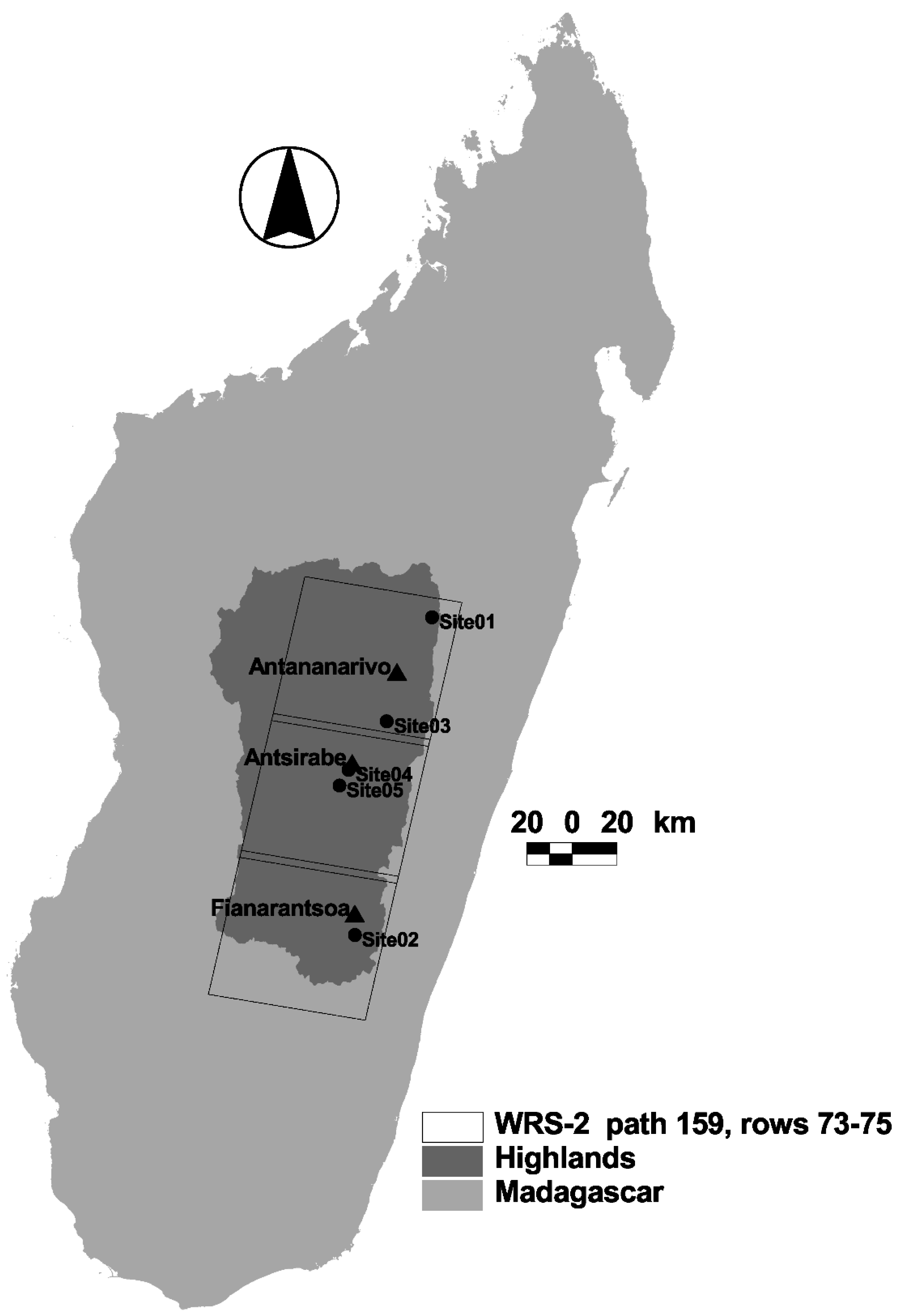
A vast literature exists documenting the loss of forest in Madagascar, almost exclusively focusing on what is considered “natural” or pristine formations, under the assumption that greater height, greater canopy closure and higher species diversity are indicators of habitat quality for endangered wildlife, such as lemurs. These assumptions may generally hold for the purposes of conserving biological diversity. However, from the standpoint of local livelihoods, woody species play important roles at much lower density and diversity.
Detecting the presence of woody cover at low densities using traditional remote sensing techniques presents methodological challenges and this, along with the conservation motives of most land-cover change studies in places like Madagascar, means that changes involving such land covers are typically not captured. In particular, traditional satellite image processing techniques reflect cartographic technology favoring choropleth maps, in which the landscape is divided into units of internally homogenous land-cover types, with the number of categories limited to ease the readability of the map. In practice, however, it is quite rare for studies to actually specify what they consider to constitute forest cover. For example, among nearly two dozen studies of land change in Madagascar (See Table S01 in Supplementary Materials), we were able to identify only one that provided an explicit definition of forest. Harper and colleagues, in their review of half a century of deforestation and forest fragmentation in Madagascar, defined forest as “areas of primary vegetation dominated by tree cover at least seven meters in height, with neighboring tree crowns touching or overlapping when in full leaf” ([1]; p. 2). The issue of conflicting definitions of forest is treated explicitly by Dufils [48], and McConnell and Kull [49].
The past decade has witnessed rapidly growing interest in the development of techniques for the classification of remotely sensed imagery to obtain continuous depictions of the landscape, along gradients such as “percent tree cover” [50]. Such techniques allow the detection of trees and other woody vegetation at a range of densities, including those with important livelihood implications that are overlooked in most studies. At the same time, the rapid increase in the availability of recent high resolution commercial satellite imagery, through platforms such as Google Earth®, provides an unprecedented ability to collect the kind of information needed to “train” an automated classification of multispectral imagery. Of course, understanding the causes of the changes revealed through these remote sensing and image classification techniques still requires “boots on the ground.” The present study brings together decades of such concerted fieldwork with novel remote sensing techniques to document and explain changes in the open woodlands, woodlots and orchards of highland Madagascar.

2. Study Area

Madagascar is classified as a low-income country by the World Bank, with 88 percent of the population subsisting on $1.25 per day, and four-fifths of the population consists of families operating farms averaging roughly 1 ha with manual labor and animal traction. Large, mechanized farms are the exception. The smallholder farms face high transport costs due to poor infrastructure, usually combining subsistence and market-oriented production. Most market production is destined for local or regional (within the island) consumers, though certain regions have found specialized export niches, such as green beans in the central highlands around Antananarivo [51,52,53,54].
Like elsewhere in Africa, farmers seek to diversify their livelihoods as a risk-reduction strategy. If they can, households combine crop production, livestock rearing, unskilled wage labor, seasonal or periodic migration (as labor on farms or in mining), small-scale artisanal or trading activities, urban employment, opportunistic resource exploitation, and other activities [53,55]. In this way, households respond to opportunities and constraints, such as the expansion of economic opportunities linked to preferential trade agreements [53], or the contraction of the livestock sector due to increased dangers of cattle rustling [56]. Natural resource extraction helps as a safety net in the case of crises, whether drought, cyclone, market shifts, or illness or death of household labor [57,58]. Woody tree species—whether native, planted, or invasive—often serve such a role, offering rural people either regular income or a kind of backup option to earn supplemental cash in times of difficulty [59,60].
The central highlands (defined by the current administrative regions of Bongolava, Analamanga, Itasy, Vakinankaratra, Amoron’i Mania and Haute Matsiatra; Figure 1) cover an area of approximately 96,000 km2, contain three of the island’s largest cities (including the capital), and support nearly half (ca. 7.5 million) of the island’s human population. Total annual rainfall decreases westward, with the eastern portion of the highlands hosting tropical rainforests, while the western portion is mostly composed of low productivity rangeland. The human imprint on Madagascar’s highlands is characterized by a mix of irrigation infrastructure and extensive cattle grazing, illustrating the blending of African and Asian cultural heritages [61,62]. Farmers cultivate irrigated rice and a number of upland crops, such as manioc, sweet potatoes, beans, and potatoes. All farms keep at least some animals, and the region’s grasslands are typically burned nearly every year to provoke late dry season forage for cattle, and to prevent bush encroachment [63]. These fires, combined with the region’s ubiquitous erosion gullies, known as lavaka, have given the highlands a reputation as a site of environmental degradation [64,65,66].

3. Methods

The application of forest transition theory in landscapes dominated by smallholder plots requires a multi-level approach that enables the consistent detection of woody cover dynamics across a broad area, combined with highly contextualized explanations of processes occurring in specific landscapes. We therefore begin with a broad scale assessment of land-cover change using innovative techniques for the classification of moderate resolution (i.e., 30m horizontal resolution) satellite imagery. The procedure yields change maps that highlight particularly dynamic areas, from which we select some for closer examination using field observations in combination with ancillary information.

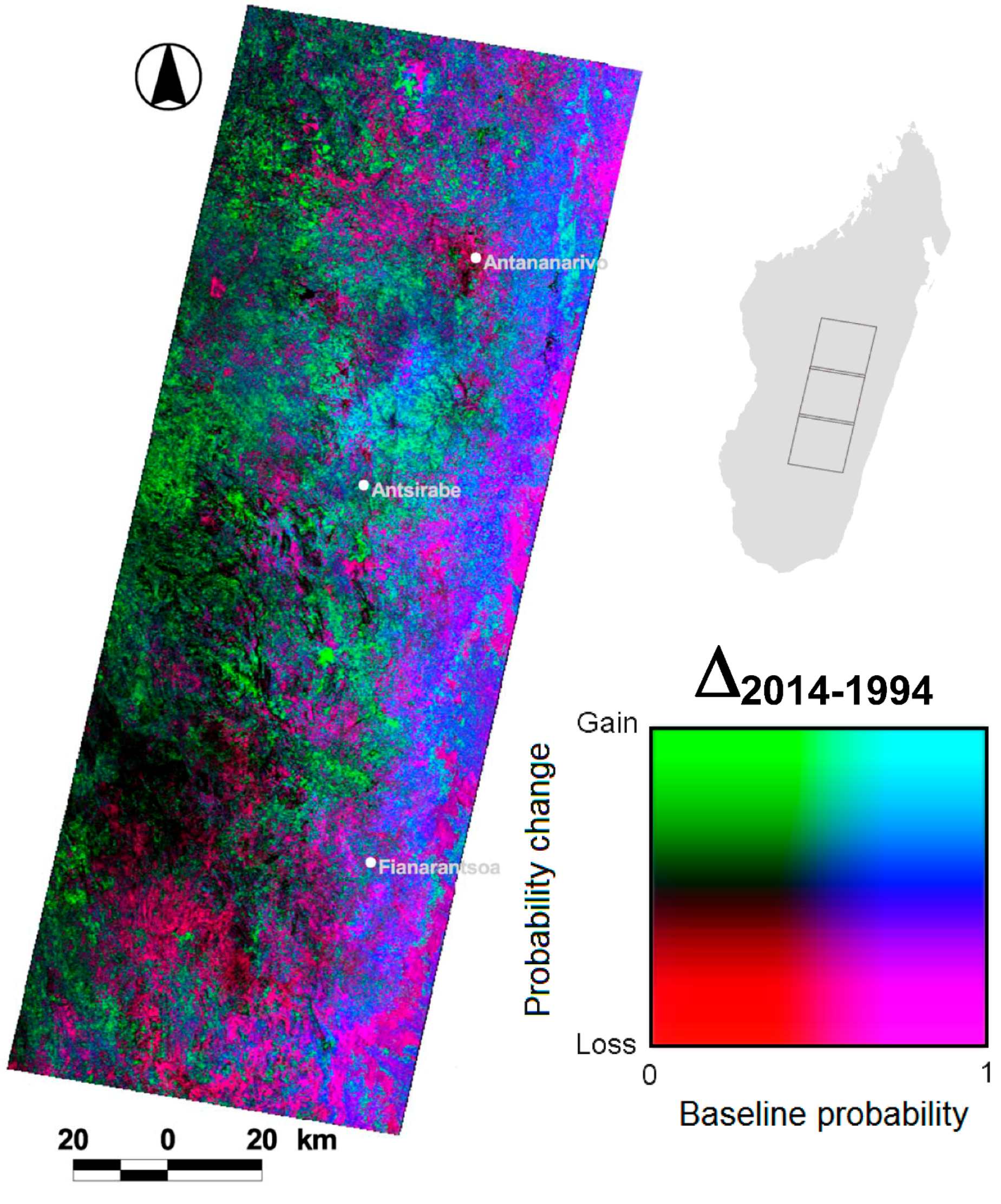
3.1. Remotely Sensed Data, Digital Image Processing and Change Detection

Woodland dynamics in the highlands were evaluated using three multi-spectral scenes (path 159, rows 73 to 75 of the World Reference System-2 (WRS-2)) acquired by the Thematic Mapper (TM) sensor onboard the Landsat-5 satellite system and by the Operational Land Imager (OLI) sensor onboard the Landsat-8 satellite system on September 25, 1994 and September 16, 2014, respectively. The use of anniversary data from the dry season (i.e., September) was preferred because it enabled the use of mostly cloud-free scenes. These scenes account for ca. 80 percent of the central highlands (Figure 1).
Figure 1. The study region was defined by the area within three Landsat scenes (path 159, rows 73 to 75 of the World Reference System-2 (WRS-2)), comprising ca. 80 percent of Madagascar’s Highlands. Also shown are the locations of three main cities and five field sites visited between 2003 and 2006 whose land-cover dynamics are explained in more detail in the text.
Land 04 01155 g001
The three scenes per date were mosaicked, and a relative radiometric normalization was applied to render the radiometric structure of the scenes from the two anniversary dates (i.e., 25 September 1994 and 16 September 2014) comparable. The normalization consisted of the development of linear regression models for each of six optical bands (i.e., bands 1–5 and 7 of the Landsat TM, and bands 2–7 of the Landsat OLI), to predict the brightness values of the 2014 imagery that would have been obtained had they been acquired under the same atmospheric conditions as the 1994 imagery. A total of 40 pseudo-invariant targets (i.e., wet and dry targets present in both scenes assumed to be constant reflectors through time so that any changes in their brightness values could be attributed to sensor calibration, astronomic, atmospheric and phase angle differences) were used to develop the linear regression models. Table 1 shows the coefficients of these models.
Table 1. Coefficients of linear regression models (one for each spectral band) developed using pseudo-invariant targets. These linear models were constructed in order to match the radiometric structure of the six optical bands of the 16 September 2014 Landsat Operational Land Imager (OLI) imagery to that of the September 25, 1994 Thematic Mapper (TM) imagery.
BandSlopeInterceptR2
Blue0.013−51.1280.928
Green0.007−28.1630.910
Red0.008−33.2070.949
Near Infrared0.006−20.4270.971
Shortwave Infrared 10.010−44.6850.986
Shortwave Infrared 20.007−32.1210.978
We estimated the probability of an area to exhibit woody cover using a fuzzy classification algorithm based on the principle of maximum entropy [67] using MaxENT, a general purpose machine-learning method for making predictions from incomplete information [68]. To calibrate and validate the maximum entropy classification algorithm, we developed a dataset of 280 “ground truth” polygons of the same area as a Landsat pixel (ca. 900 m2) semi-randomly distributed throughout the study area, in which the interpretation of an initial set of 250 randomly distributed polygons was used to oversample in areas exhibiting some woody cover. Within each of these polygons we randomly distributed 10 points. Using high spatial resolution imagery available in Google Earth®, we visually ascertained the number of points per polygon coinciding with a tree canopy. To assess the reliability of the interpretation of imagery in Google Earth®, two image interpreters independently performed the point counts. The average point count between the two interpreters was obtained, and only those polygons that exhibited a point count difference of 10 percent or less between the two interpreters were used.
Following the classification of forested areas established by the United Nations Food and Agriculture Organization [69], we employed a threshold of 10 percent tree cover as a definition of woodland (encompassing closed canopy forest, plantations, treed savanna, riparian growth and sometimes dense shrubland), and considered a polygon to be at least 10 percent covered by woody vegetation if one or more points per polygon coincided with such cover. Out of the 280 ground truth polygons, 97 (i.e., 34.6 percent) had 10 percent or greater woody cover. Using these data together with the MaxEnt algorithm, we created a woody cover probability (i.e., the probability of having tree cover of 10 percent or higher) map from the multi-spectral bands (i.e., bands 2–7) of the 2014 Landsat imagery. The output probability map was validated using a cross-validation procedure in which 2/3 of the ground truth polygons were used for calibration and the remaining 1/3 used for validation. To reduce dependence on a single random partition into calibration and validation, we generated 10 different random partitions to be used in 10 different classifications, which were then averaged. The 10 output probability maps were validated by means of a receiver operating characteristic (ROC) curve [70]. The ROC curve is a plot of the sensitivity values (i.e., true positive fraction) vs. their equivalent 1-specificity values (i.e., false positive fraction) for all possible probability thresholds. The area under the ROC curve (AUC) is a measure of model accuracy, with AUC values ranging from 0 to 1, where a score of 1 indicates perfect classification, a score of 0.5 implies a classification that is not better than random, and values lower than 0.5 imply a worse than random classification. The average AUC value was 0.872, which was significantly (p < 0.0001) different from 0.5 and denotes high classification accuracy. The average coefficients of the validated classification of the multi-spectral bands of the 2014 Landsat OLI imagery were then applied to classify the multi-spectral bands (bands 1–5 and 7) of the 1994 Landsat TM imagery.
A simple image differencing technique (in essence, a post-classification comparison [71]), in which the probability of woody cover in 1994 was subtracted from the 2014 probability, was performed on a per-pixel basis yielding a continuous measure of change over 20 years from the 1994 probability, which was used as the baseline. This procedure yields an output map that depicts spatial patterns of more subtle dynamics than is captured by more traditional image “hard” classification approaches in which each pixel is assigned to one of a fixed set of categories. The dynamics revealed by the multi-date Landsat imagery include: no significant change in probability, which we interpret as stability; an increase in probability, which we interpret as gain in woody cover; and a decrease in probability, which we interpret as loss in woody cover. These dynamics were then further explored using the high resolution imagery from Google Earth®, in conjunction with aerial photographs from the early/mid 1990s, along with ground level photos and field visits conducted midway through the study period (i.e., 2003 and 2006).

3.2. Explaining the Observed Woodland Dynamics

Interpretation of the documented land change patterns was based on field observations and previous studies over the past two and a half decades, in conjunction with the published literature. In particular, we relied on two dozen case study sites (selected using a spatially stratified random sample) previously investigated using 1950s and 1990s air photos as well as field visits [72]. Then, in this two-step Land Change Science–Political Ecology study, we move from the more descriptive remote sensing and case study site discussion of tree cover changes to an investigation of the various factors lying behind these changes. Following a political ecological framework, attention was accorded to not only market incentives, demographic pressure, and official policies, but also to access to resources and to the livelihood strategies of rural residents including land tenure arrangements, de-facto rules around trees, and environmental ideologies, as well as the invasive characteristics of some of the trees themselves [55,73,74].

4. Results

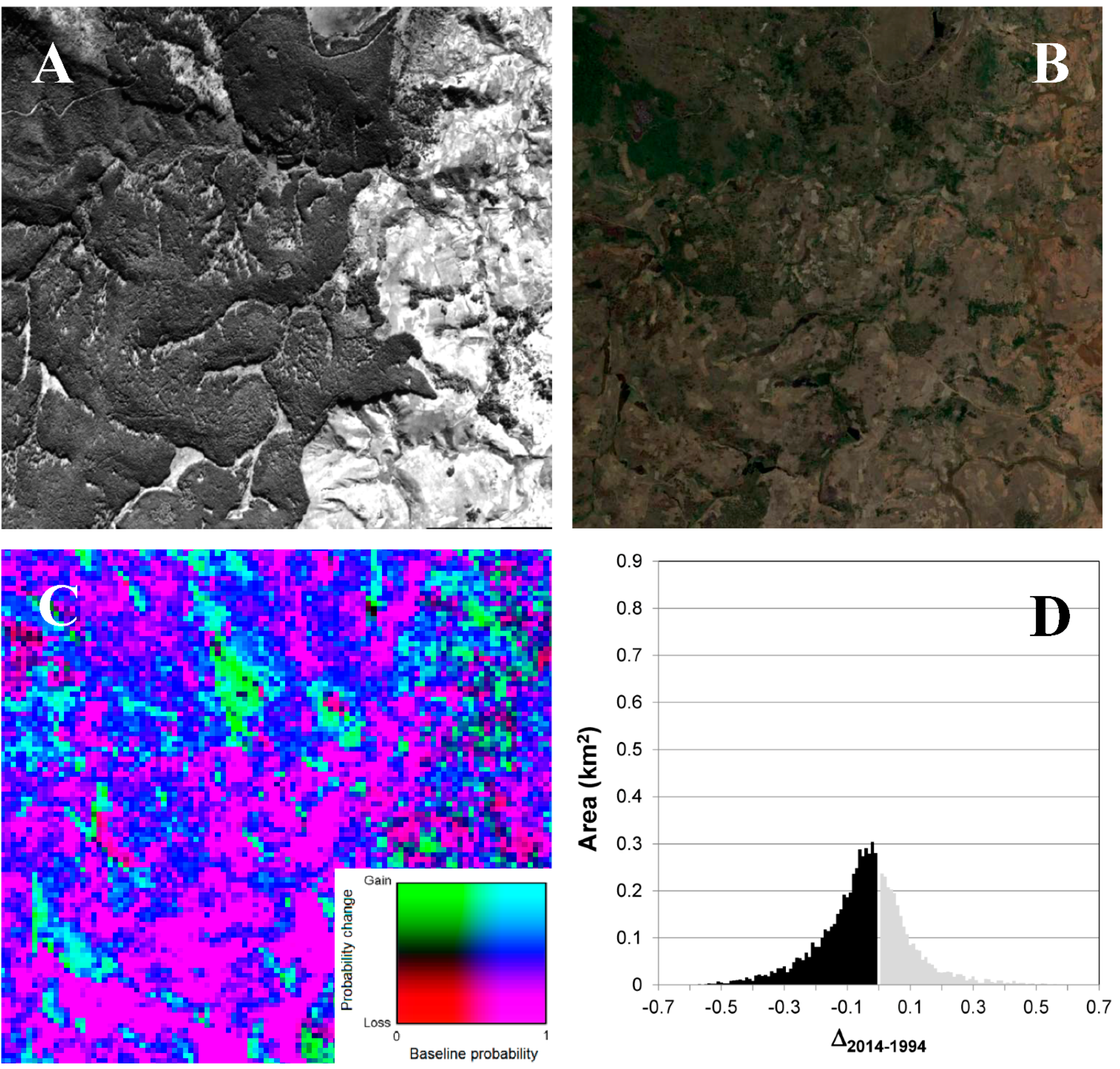
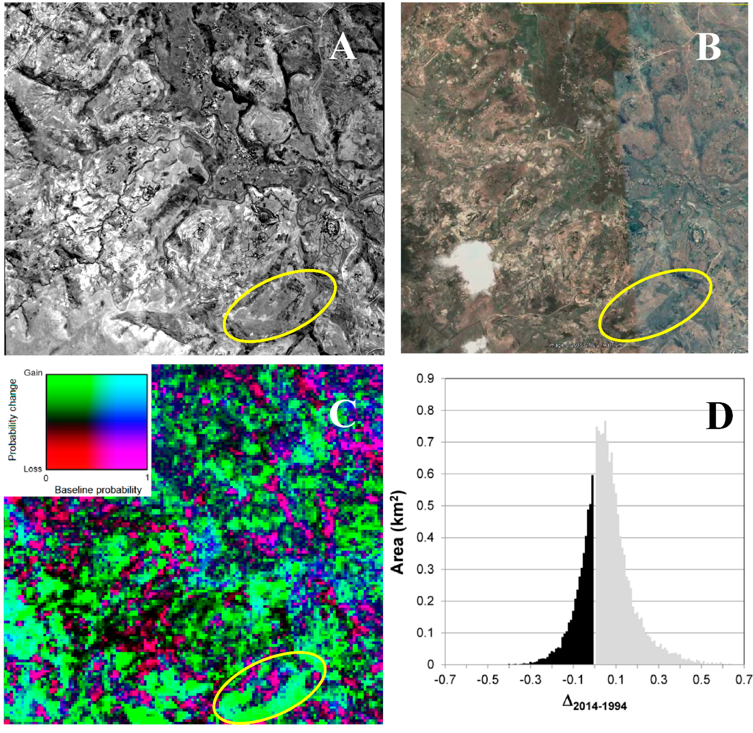
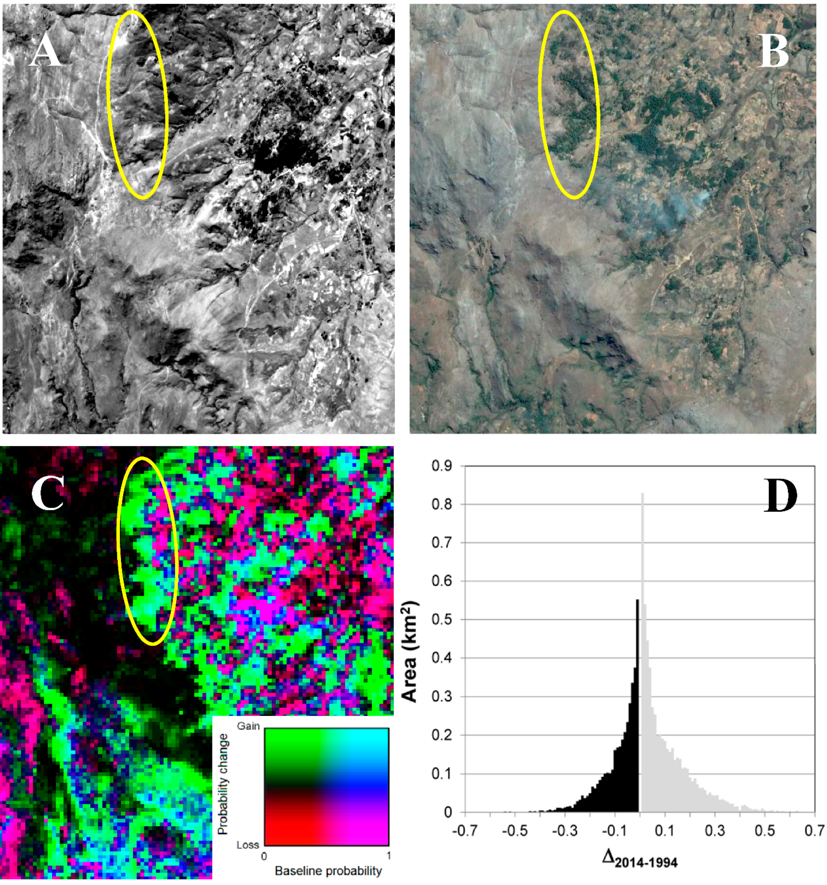
4.1. Remote Sensing and Case Study Analysis

The results of the probability map differencing procedure are shown in Figure 2. Increases and decreases in probability between 1994 and 2014 (expressed in the map as gains and losses, respectively) represent increases and decreases in woody cover. Increases in woody cover are indicated in shades of green, and decreases in shades of red, while the initial cover (i.e., baseline probability value in 1994) is given by shades of blue. The combinations of these colors yield gradations among six trends depicting woody cover dynamics between 1994 and 2014 over the study area. What is notable is the wide extent of increasing tree cover, particularly in interior highland areas often treated in broad scale assessments as essentially devoid of trees. Below, we describe in detail the three main categories of change shown in Figure 2 (landscape stability, decreases in woody cover, and increases in woody cover), linking the general patterns to specific dynamics revealed in drill-down analyses of the specific case study sites.
Figure 2. Spatial distribution of the temporal dynamics (i.e., gain, loss, no change) of woody cover in the study area over a 20-year period (i.e., 1994–2014), as a function of the baseline probability of woody cover (i.e., probability of woody cover in 1994). Also shown are the locations of the three major cities (including the capital) in the Highlands of Madagascar.
Land 04 01155 g002
First, stable landscapes are represented in Figure 2 with black and blue tones, representing herbaceous and forest landscapes, respectively. In the case of more dense (higher probability) woody cover in 1994, this stasis is rendered in dark blue, which one would expect from undisturbed forest. This dynamic is seen in the eastern portion of the study area, which contains the region’s remaining dense forests, along the eastern escarpment of the highlands, as well as in some of the larger and longer-term zones of woodlot forests (e.g., east of Antananarivo).
The darkest tones in the map represent areas that had a low probability of woody cover at either date, and these are concentrated in the western, and especially southern, portion of the study area, which are also drier and less populated (Figure 2). These areas are often characterized by lateritic soils with minimal organic layers. Typically, herbaceous vegetation covers the uplands, with woody vegetation restricted to slope hollows and the edges of streams and seasonal drainages.
A second category of change is decrease in woody cover. A decrease in woody cover is unlikely when the initial probability was low, explaining the paucity of deep red in Figure 2. This dynamic could result, though, from the burning of grasslands containing shrubs and occasional trees, but occurs quite infrequently in our results. Much more common are decreases from a more dense initial cover, shown in magenta. This dynamic is particularly visible along the far eastern edge of the study area, and corresponds to significant degradation of woody cover, as would be expected from clearing of forest for agriculture (Figure 2). In this region, it is likely that some—or even most—of these forests had been subject to some degree of disturbance prior to 1994, but our study period only comprises the dynamics after 1994, which prevents us from distinguishing such prior disturbance. Elsewhere, however, our fieldwork and the literature allow us to identify the conversion of dense forest to other land-cover types. We recognize two distinct processes, one involving cyclical loss of canopy, known as a coppice. This entails removing the stems of tree species capable of re-sprouting from their stump, a property that has made several species of eucalyptus very popular in Madagascar. The large eucalyptus plantations around the capital (Antananarivo), including the Manjakandriana Massif, have been well-described [75]. Such coppicing appears in the change map as large magenta blocks around the black mass of the city in the northeast portion of the study area (Figure 2), interspersed with increases in woody cover (described below).
Smaller, more dispersed stands of eucalyptus have heretofore received less attention in the peer-reviewed literature, but are revealed in our results. A good example is our field site at Ambongabe, north of Anjozorobe (Site 01; Figure 3), where dense woody cover visible in the 1992 aerial photograph was much more open in a 2014 Digital Globe image, resulting in bright magenta tones in the change map. Zooming in on the high resolution imagery reveals this to be a well-organized hilltop plantation with large crowns in 1992, and much smaller crowns in 2014 (Ellipse 1 in Figure 3). Our fieldwork confirms this to be a eucalyptus plantation, which was probably coppiced twice during the intervening 20 years.
Another process explaining decreased woody cover, particularly in plantations, involves more complete harvesting. The study area includes several large government and private plantations subject to regular clearcutting and replanting, much as in other parts of the world. Some of our field sites, however, are characterized by a spectrally similar, yet institutionally different, process. The Landsat change map is dominated by bright magenta tones (representing decreased woody cover) at our Ambozontany field site (Site 02, Figure 4) where portions of the government’s Haute Matsiatra pine plantations—shown in the 1991 aerial photos to be closed canopy plantations—had been cleared for upland cultivation when Digital Globe’s sensor recorded an image in October of 2014. This process was well under way during a field visit in 2006, which revealed that this conversion represented the unsanctioned actions of communities who had previously been dispossessed of the land for the creation of the state plantations during the first decade following Independence. The village lands in the eastern third of the image have their usual eucalyptus woodlots, but the pine stands were rather threadbare (see Figure S1 in Supplementary Materials).
Figure 3. Dynamics of woody cover at Site 01, Ambongabe, near the town of Anjozorobe north of Antananarivo (18°19'S, 47°54'E). (A) Aerial photograph taken in 1992. (B) Digital Globe image taken in 2014. (C) Change map based on Landsat imagery (see Figure 2). (D) Histogram depicting the frequency distribution of the delta of woody cover probability values between 2014 and 1994 based on Landsat imagery. Woody cover loss is represented in black, while gain is represented in gray. Ellipses in (A–C) relate to particular woody cover dynamics described in the text. See Figure 1 for the geographic location of Site 01 within the study area.
Land 04 01155 g003
Figure 4. Dynamics of woody cover at Site 02, Ambozontany, south of Fianaratsoa (21°48'S, 47°6'E). (A) Aerial photograph taken in 1991. (B) Digital Globe image taken in 2014. (C) Change map based on Landsat imagery (see Figure 2). (D) Histogram depicting the frequency distribution of the delta of woody cover probability values between 2014 and 1994 based on Landsat imagery. Woody cover loss is represented in black, while gain is represented in gray. See Figure 1 for the geographic location of Site 02 within the study area.
Land 04 01155 g004
The third and final set of dynamics, representing increases in woody cover, is concentrated in very different parts of the landscape. In the Landsat change map cyan tones represent an increase from an already dense initial cover. These are predominantly found in the eastern area, where secondary growth often occupies land previously cleared for agriculture (Figure 2). They are also particularly visible north of Antsirabe, in a region with a long history of woodlot plantations that continues to intensify. These frequently co-occur with magenta tones, in landscapes where fallow periods are long enough for woody vegetation to reestablish itself following cultivation. This dynamic was also observed, however, farther west, where forests were rare or absent in 1994. For example, in the same field site at Ambongabe described above (Ellipse 2 in Figure 3) as showing evidence of eucalyptus coppices, we see evidence of hilltops covered in brush in 1992 that later showed tree canopies.
Of great interest to the present study are areas appearing in the Landsat change map in bright green tones, representing substantial increases in woody cover over the 20 year period. This can only occur when initial woodland probability was low, and is concentrated in the central and western portions of the study area. Three of our field sites exhibit these dynamics.
Near Ambatolampy (Site 03; Figure 5) well-organized plantations were already evident in the 1991 aerial photographs, and the 2013 CNES Astrium image shows these had expanded significantly, resulting in bright green tones in the Landsat change map (Ellipse 1 in Figure 5). Field work confirms these to be eucalyptus plantations. Farther west at the same site is a dense, well-managed pine forest, with some araucaria, sweet gum, and silver wattle. This is a private 48 ha land holding of a family residing in the capital (Ellipse 2 in Figure 5). A ground-level panorama shot in 2003 (Figure S2 in Supplementary Materials) shows the widespread, low-density eucalyptus plantations, as well as a foreground “scrub” of Helichrysum spp. and silver wattle.
Meanwhile Ambohijatovo (Site 04; Figure 6) is a typical intensively cultivated central highland site, marked by eucalyptus woodlots, rice fields, and market vegetables, as shown in a panorama photo taken in 2003 (Figure S3 in Supplementary Materials) from the valley bottom. Comparing the 1991 aerial photograph and the 2013 CNES Astrium image reveals the expansion of a hilltop plantation down to the rice paddies in the valley bottom, once again shown in the Landsat change map in shades of green (Ellipse in Figure 6). Likewise, in the western portion of our Soamahazina site (Site 05; Figure 7), an expansion of tree cover is evident between 1991 and 2013, showing up in the Landsat change map in shades of green. Fieldwork in 2003 documented the development of village woodlots in these cool uplands (1700-2000m) where transport is relatively difficult, but the site is close enough to the town of Antsirabe that charcoal production is economically viable (Ellipse in Figure 7). The haphazard arrangement and sizes of the trees at this site suggest that these woodlots are being expanded in incremental fashion, different from the more regimented rows of even-aged trees seen in other sites.
Finally, it should be noted that there are other “new” tree covers than the spatially dominant eucalyptus and pine woodlots, also responsible for the green tones in the Landsat change map. In particular, Kull [72,73,76] documented a dynamic involving fruit orchards, hedge trees, ornamentals, and other trees in and around settlements. Given their spectral similarities at low stem densities, these cannot easily be distinguished from other woodlots in our remote sensing analysis, but result from different land management processes. Such a landscape element is shown in the panorama photo (Figure S3 in Supplementary Materials) of the Ambohijatovo case study (Site 04), notably on the right hand side (location indicated in Figure 6).
Figure 5. Dynamics of woody cover at Site 03, south of the town of Ambatolampy (19°25'S, 47°25'E). (A) Aerial photograph taken in 1991. (B) CNES Astrium image taken in 2013. (C) Change map based on Landsat imagery (see Figure 2). (D) Histogram depicting the frequency distribution of the delta of woody cover probability values between 2014 and 1994 based on Landsat imagery. Woody cover loss is represented in black, while gain is represented in gray. Ellipses in (A–C) relate to particular woody cover dynamics described in the text. See Figure 1 for the geographic location of Site 03 within the study area.
Land 04 01155 g005
Figure 6. Dynamics of woody cover at Site 04, Ambohijatovo, centered on a rice cultivating valley just south of Anstirabe (19°56'S, 47°0'E). (A) Aerial photograph taken in 1991. (B) CNES Astrium imagery taken in 2013. (C) Change map based on Landsat imagery (see Figure 2). (D) Histogram depicting the frequency distribution of the delta of woody cover probability values between 2014 and 1994 based on Landsat imagery. Woody cover loss is represented in black, while gain is represented in gray. Ellipses in (A–C) relate to a particular woody cover dynamic described in the text. See Figure 1 for the geographic location of Site 04 within the study area.
Land 04 01155 g006
Figure 7. Dynamics of woody cover at Site 05, Soamahazina, an upland area southwest of Antsirabe (20°06'S, 46°54'E). (A) Aerial photograph taken in 1991. (B) CNES Astrium taken in 2013. (C) Change map based on Landsat imagery (see Figure 2). (D) Histogram depicting the frequency distribution of the delta of woody cover probability values between 2014 and 1994 based on Landsat imagery. Woody cover loss is represented in black, while gain is represented in gray. Ellipses in (A–C) relate to a particular woody cover dynamic described in the text. See Figure 1 for the geographic location of Site 05 within the study area.
Land 04 01155 g007

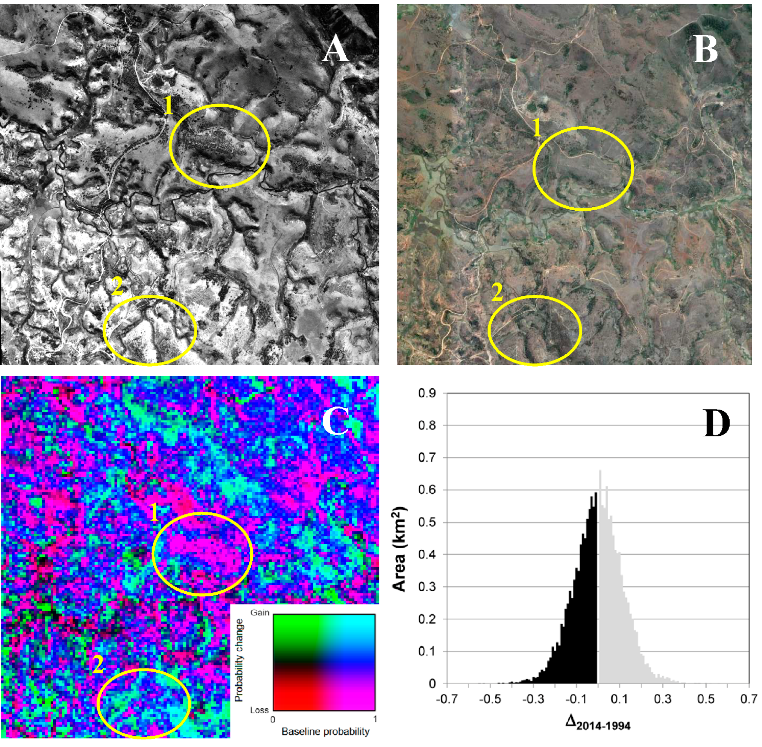
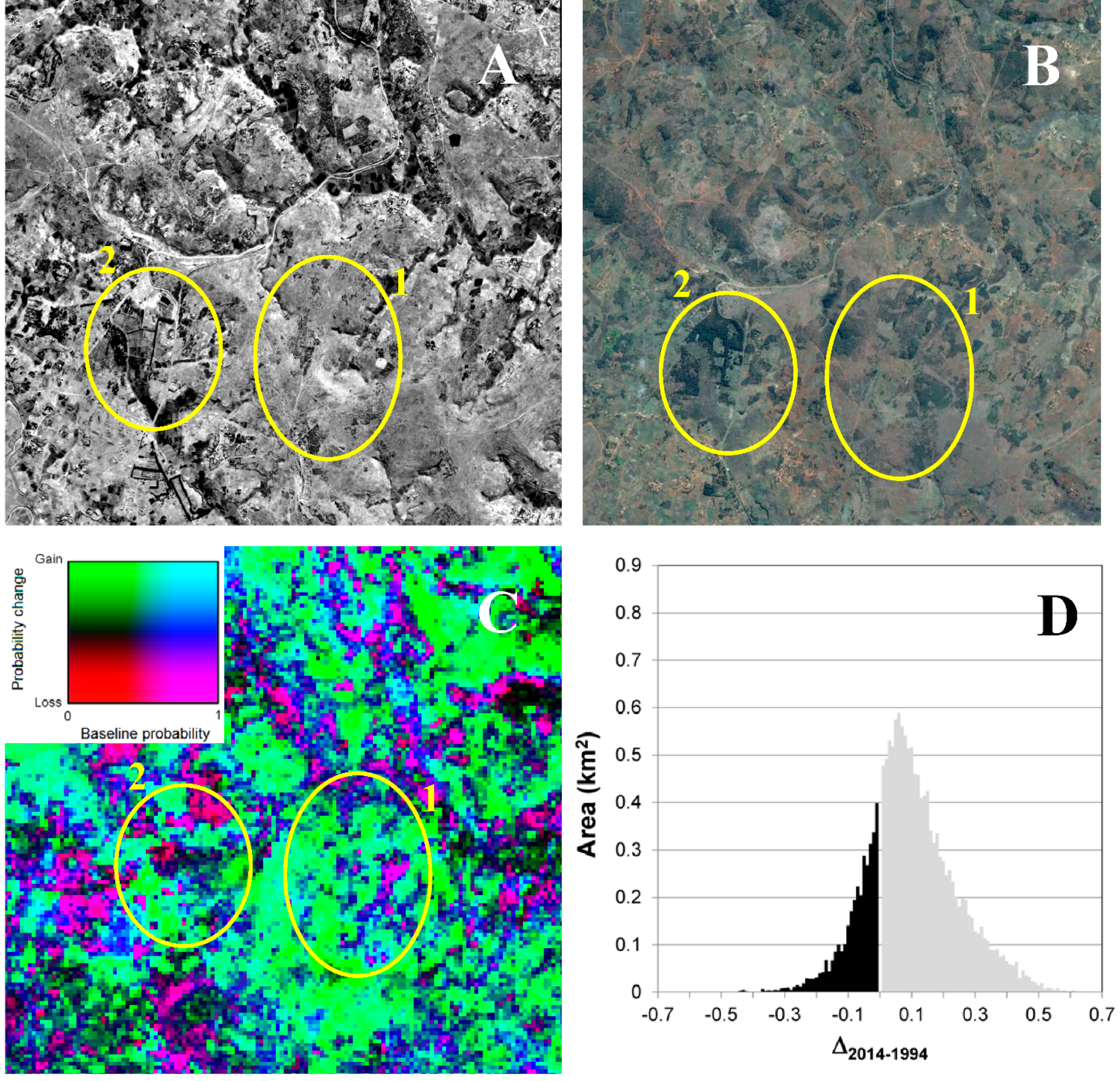
4.2. Political Ecological Context of Tree Cover Change

A variety of intertwined endogenous and exogenous factors can be shown to lie behind the tree cover dynamics of the highlands. Six factors emerged from the analysis of the empirical case study sites and the literature: household livelihood strategies, urban market demand, land tenure struggles, dominant environmental ideas and resulting policy, government forestry interventions, and the invasiveness of some of the trees themselves. Each of these factors was already operative at the beginning of the study period. We argue that the conjuncture of these processes spurred the tree cover increase (following [77] and [78]). Further research could determine the precedence of particular factors in different places. We review each factor in turn.
First, a vast array of household needs is met by the trees increasingly covering the highlands. They are utilized in diverse ways, sometimes to meet subsistence needs, sometimes for cash income. Domestic fuel in rural areas comes almost purely from locally grown woody cover. Construction uses include floors, roofs, balconies, railings, stairs, cattle pens, pig sheds, and fence posts. Carpentry uses include beds, chairs, tables, cooking utensils, oxcarts, toys, and much more. Fruit trees and shrubs—from oranges to mangos, from vines to peaches—provide obvious consumable and marketable products, as well as secondary uses of dead branches as fuel wood, and mulberry leaves as silk worm fodder, among many other uses. Other benefits derived from trees include the production of honey based on eucalyptus flowers, the improvement of soil fertility based on acacia nitrogen fixation, and the sale of eucalyptus essential oils [79,80,81]. It is important to note that population growth in Madagascar is still quite rapid, with the country’s population doubling between 1990 and 2013. Meanwhile, economic stagnation in urban areas has actually led to highly unusual urban-to-rural migration [82]. At the same time, the benefits previously derived from the cultivation of uplands have decreased with declining soil quality, while the benefits of grazing cattle have been undermined by increasing cattle rustling [56], which may in turn be interpreted as symptomatic of a weak, neopatrimonial state [83].
Second, urban market demand for wood fuel—particularly charcoal for urban consumers, or even to run industrial installations—as well as for construction wood, drives investment in woodlots [55,75,79,80,84,85,86,87]. Several areas of the highlands contain landscapes particularly devoted to the production of charcoal, firewood, and wood products. The most notable are the eucalyptus-dominated hills east and northeast of the capital, in the districts of Manjakandriana and Anjozorobe, where over 70 percent of the land—mostly former grassland—is now treed. At a smaller scale other similar landscapes are found outside other highland cities, such as the high-elevation pine and wattle groves between Antsirabe and Faratsiho [80].
Third, land tenure issues play a contributing role. Since around 1930 and continuing to the present, the plantation of woodlots was recognized by the state as evidence of land appropriation and development, a prerequisite to formal title registration (it should be noted that, in contrast, extant native forests were long ago declared state domain). Thus, urban and rural investors not only benefit from a growing urban market demand for the products from their woodlots, but they can also use the woodlots as part of a strategy to claim title to lands otherwise considered state-owned [55,84,88] or to lay out claims to common lands.
Fourth, it is important to understand the context of prominent environmental discourses in shaping perceptions of the highlands and policy responses. From early colonial days through to the present, scientists, foresters, and government agents have perceived the highlands as “barren” and deforested, and in need of “re-greening.” This discourse is based both in a concern over soil degradation and biodiversity loss, as well as more pragmatic concerns with the supply of fuel and construction material [64,72]. Understanding the context of prominent environmental discourses is crucial to understanding government interventions, the next factor.
Fifth, both the colonial and independent governments, together with non-governmental organizations (NGOs), have repeatedly promoted the afforestation of the highlands. Tree planting to create communal forest reserves was at times obligatory and at other times a punishment for crimes [64,89]. The government’s Direction des Eaux et Forêts (the Forest Service), founded at the dawn of French colonial control, still oversees a number of tree nurseries, forest stations, and forest plantations. Forestry stations, such as Manankazo (near Ankazobe), Manjakatompo and Antsampandrano (on the Ankaratra massif) and Angavokely (east of the capital) oversaw important reforestation projects and are at the center of regions with smallholder woodlots. The Forest Service also embarked on large, industrial plantations of Pinus spp, in particular in the Haute Matsiatra, northeast and southeast of Fianarantsoa as well as the Haute Mangoro, north of Moramanga (outside our study area). In the past two decades, however, the approaches have been more voluntary, sponsored for instance by projects run through local and foreign NGOs, aid agencies, universities, and conservationists. As just one example among many, the overseas wing of the French Office National des Forêts sponsors the work of the Malagasy NGO Tany Meva to plant trees across a few hundred hectares in a municipality some 30 km outside the capital [90]. At the same time, the state’s inability to provide rural security has created disincentives to traditional livestock practices and surplus grain production, thus encouraging a shift in land use favoring trees, while its regulation of the charcoal trade has had mixed results [91] (see also [92] on the issue of corruption in law enforcement in Madagascar generally, and [93] on the specific question of conservation enforcement).
Sixth, and finally, the trees themselves have played a role in expanded tree cover in the highlands, taking advantage of suitably invasible landscapes. In particular, both pines and acacias have been relatively successful in reproducing themselves and dispersing from initial plantations [94], mirroring their behavior elsewhere [95,96].

5. Discussion and Conclusions

5.1. On Pathways and Processes of Forest Transitions and Landscape Change

While the rainforests of the eastern side of Madagascar’s highlands continue to be exploited, a dynamic of woodlot rotations and tree planting is transforming the central and western highlands. Based on the state-of-the-art remote sensing evidence, we argue that this represents an incipient, sub-national forest transition. Building on the analysis of factors facilitating this trend, we furthermore argue that this transition follows a “scarcity” pathway pushed and pulled by endogenous and exogenous factors [97].
The land-use transition underway in the highlands of Madagascar shares little with other cases prominent in the forest transition literature. The economic development pathway is not relevant, since neither rural depopulation driven by industrialization nor rising affluence are operative in Madagascar, where the opposite trends are at work [82]. As for the traditional forest scarcity pathway, the few large-scale government-sponsored plantations account for a modest portion of the increased woody cover detected, and many of those were seen to be reverting to agricultural uses. Meanwhile, there are no large-scale private operations like the rubber and palm oil plantations of Southeast Asia. The situation in Madagascar bears some resemblance to the “smallholder stewardship” dynamic in the Ecuadorian Amazon described by [98], in which farmers with abundant land and labor are increasingly allowing certain trees to grow in their pastures. In the Malagasy highlands, though, pasture clearing is typically less labor-intensive than in Amazonia and, while farmers allowing spontaneous regeneration is certainly a part of the story, smallholders are also purposely planting trees that would not otherwise occur. Perhaps more instructive is the Vietnam case presented by Lambin and Meyfroidt [99] and [100], in which smallholders incorporate trees in their landscapes in response to a mix of endogenous and exogenous factors. In that case, the key exogenous factors included market liberalization and land tenure reform, which increased the relative profitability of lowland cultivation, leading farmers to reallocate labor from shifting cultivation, and planting the uplands with trees. In the case of highland Madagascar, market liberalization has not spurred a similar intensification of paddy land, despite massive investment by the United States Agency for International Development and other donors. Rather, it appears that continued uncertainty in rice prices, in concert with the increasing risk of theft—both of grain stores and cattle purchased with the proceeds—have created incentives for farmers to use former grazing land to plant trees. Thus, external factors, including the provision of material, knowledge and incentives to plant trees at the micro level, seem to have combined with the state’s inability to provide functioning markets and rural security to spur farmers to plant trees. To our knowledge, this pathway to the forest transition has not been documented elsewhere.
Outside the forest transition literature, the predominant way to understand the long-term evolution of the highlands landscapes has been the Boserupian model of agricultural intensification linked to intertwined growth of population, markets, and property structures [101,102]. For instance, Rakoto Ramiarantsoa [55] has called the style of population-driven agricultural intensification and expansion found at the margins of the central highlands “mérinisation,” by which he refers to a progressive transformation of open land to an intensively-cultivated cultural landscape typical of the Merina ethnic group in its homeland of Imerina, centered around the capital city. His concept imbues the Boserupian process with a cultural symbolic role. Yet his use of the term does not capture the conquest of the highlands by woodlots of exotic forestry tree species. Indeed, Rakoto Ramiarantsoa calls these eucalyptus-draped landscapes a departure from the Merina model ([55]; p. 299). Given the widespread adoption of these trees into peoples’ livelihoods and landscapes over the past century (as he himself documents: e.g., [103]), these trees arguably deserve to be considered as an integral part of current day highland landscapes, whether Imerina or other cultural and regional divisions, like Vakinankaratra or Betsileo.

5.2. On Resilient Livelihoods and Sustainable Environments

What are the implications of the typically patchy, often low density, largely exotic tree cover that we have documented to be continuing to expand over significant parts of the highlands? We have demonstrated that it is central to rural livelihoods, and meets growing urban needs. Few other places in Africa can boast such a supply of locally produced items, instead being reliant on imported materials (sometimes for local manufacture) such as metal doors and window frames, cooking utensils, etc. The supply of such household goods perhaps leaves the Malagasy economy on a much more sustainable footing than it would otherwise enjoy. One could argue that this is a renewable wood supply, particularly in contrast with the rest of sub-Saharan Africa, where biomass for fuel (whether wood or charcoal) comes predominantly from natural forests. The extent and importance of private, and especially smallholder woodlots in meeting—and exceeding—subsistence needs, is a question of great importance. Madagascar, along with Rwanda, appears to be at the leading edge in the proportion of urban energy needs being met by such small-scale woodlots [104] (although doubt has recently been cast on the sustainability of Antananarivo’s peri-urban eucalyptus plantations, given observations of a shortening of the coppice cycle below the six years recommended for maximum productivity [87]).The present study contributes to our understanding of this important phenomenon.
On the policy front, the pattern of state support for, and indeed investment in, forestry plantations corroborates the findings of Chidumayo and Gumbo [105] and Zulu and Richardson [106] that the provision of woodfuel supplies from plantations has been a long-standing policy goal in many countries, but the success of large, state-sponsored plantations has been mixed. Highland farmers have long been encouraged in their afforestation efforts by the colonial and independent governments of Madagascar, despite the fact that Ghilardi and colleagues [107] report that charcoal supply is often absent from the energy policies of countries that rely heavily on this source of energy.
In some ways, this is a tale of a Machakos Miracle writ large [39]. It highlights the role of endogenous factors, with government support, as opposed to the alternative approach of large government plantations. However, caution is warranted on several counts. First, closer examination of the Machakos case has revealed that, while it may represent a laudable example of environmental rehabilitation in the face of population pressure, not all people involved benefited equally. In that Kenyan case, elite retirees returned to their home areas, bringing with them intellectual and financial capital not available to others who ended up displaced to marginal lands, with negative environmental and social consequences [108]. In the Malagasy highlands, the tree-based dynamics of land control and connections to urban markets likewise are part and parcel of the dynamics of social differentiation between local or urban elites and marginalized members of society, though perhaps without the obvious displacement to marginal lands seen in Machakos [103].
Second, the ecological consequences of expanded woody cover in the highlands remain to be investigated. The trees affect soil chemistry, soil biology, and soil erosion, as well as hydrology, often in complex ways [109,110]. Several of the species common in the new tree cover (Acacia spp., Pinus spp.) are widely known to be invasive elsewhere, which is one reason for their spread here, and a reason some farmers like them or at least see them as an opportunity. But this also constitutes a potential challenge for the future, since, for instance, pines have invaded endemic Uapaca woodlands and montane heaths.
On the more positive side, this new tree cover is unsurprisingly not of central interest to biodiversity conservation planners, yet there are indications that such landscapes are not irrelevant. For instance, some plantation forests or hedgerows may serve as corridors or nursery landscapes, particularly in the more humid forest edge areas [111,112,113,114]. In addition, the new forests have implications for Madagascar’s contributions to carbon sequestration [115].

5.3. Future Directions

We can only go so far in quantifying and explaining the changes we observe, and in understanding the social and environmental consequences, until further and more detailed field studies are undertaken. Seeking to balance and assess the complex implications of these environmental transformations in the highlands of Madagascar is a challenge; the most important and relevant assessment is probably that of the residents of the highlands themselves, for which these new woody resources constitute a treasure not to be squandered.

Supplementary Files

Supplementary File 1

Acknowledgments

Air photo analyses and fieldwork by CK were funded by the Province of Quebec (FCAR 2002-SC-79002), the Australian Research Council (DP0666131), the Anne U. White Fund of the AAG, and Monash University.

Author Contributions

WM and AV conceived the research; WM, AV, CK, and CB collected and analyzed the data; WM, AV, and CK wrote the paper.

Conflicts of Interest

The authors declare no conflicts of interest.

References

  1. Harper, G.J.; Steininger, M.K.; Tucker, C.J.; Juhn, D.; Hawkins, F. Fifty years of deforestation and forest fragmentation in Madagascar. Environ. Conserv. 2007, 34, 325–333. [Google Scholar] [CrossRef]
  2. Kull, C.A.; Ibrahim, C.K.; Meredith, T.C. Tropical forest transitions and globalization: NEO-liberalism, migration, tourism, and international conservation agendas. Soc. Nat. Resour. 2007, 20, 723–737. [Google Scholar] [CrossRef]
  3. Brannstrom, C.; Vadjunec, J.M. Notes for avoiding a missed opportunity in sustainability science: Integrating land change science and political ecology. In Land Change Science, Political Ecology, and Sustainability Synergies and Divergences; Brannstrom, C., Vadjunec, J.M., Eds.; Routledge: New York, NY, USA, 2013; pp. 1–23. [Google Scholar]
  4. Mather, A.S.; Needle, C.L. The forest transition: A theoretrical basis. Area 1998, 30, 117–124. [Google Scholar] [CrossRef]
  5. Rudel, T.K. Is there a forest transition? Deforestation, reforestation, and development. Rural Sociol. 1998, 63, 533–552. [Google Scholar] [CrossRef]
  6. Foster, A.D.; Rosenzweig, M.R. Economic growth and the rise of forests. Q. J. Econ. 2003, 118, 601–637. [Google Scholar] [CrossRef]
  7. Kauppi, P.E.; Ausubel, J.H.; Fang, J.; Mather, A.S.; Sedjo, R.A.; Waggoner, P.E. Returning forests analyzed with the forest identity. Proc. Natl. Acad. Sci. USA 2006, 103, 17574–17579. [Google Scholar] [CrossRef] [PubMed]
  8. Hansen, M.C.; Potapov, P.V.; Moore, R.; Hancher, M.; Turubanova, S.; Tyukavina, A.; Thau, D.; Stehman, S.; Goetz, S.; Loveland, T. High-resolution global maps of 21st-century forest cover change. Science 2013, 342, 850–853. [Google Scholar] [CrossRef] [PubMed]
  9. Caldas, M.; Walker, R.; Arima, E.; Perz, S.; Aldrich, S.; Simmons, C. Theorizing land cover and land use change: The peasant economy of Amazonian deforestation. Ann. Assoc. Am. Geogr. 2007, 97, 86–110. [Google Scholar] [CrossRef]
  10. Gutman, G.; Janetos, A.C.; Justice, C.O.; Moran, E.F.; Mustard, J.F.; Rindfuss, R.R.; Skole, D.; Turner, B.L., II; Cochrane, M.A. Land Change Science: Observing, Monitoring and Understanding Trajectories of Change on the Earth's Surface; Kluwer Academic Publishers: Dordrecht, The Netherlands, 2004. [Google Scholar]
  11. Lambin, E.; Geist, H.; Rindfuss, R.R. Introduction: Local processes with global impacts. In Land Use and Cover Change; Lambin, E., Geist, H., Eds.; Springer: Berlin, Germany, 2006. [Google Scholar]
  12. Rindfuss, R.R.; Walsh, S.J.; Turner, B.L.; Fox, J.; Mishra, V. Developing a science of land change: Challenges and methodological issues. Proc. Natl Acad. Sci. USA 2004, 101, 13976–13981. [Google Scholar] [CrossRef] [PubMed]
  13. Rudel, T.K.; Coomes, O.T.; Moran, E.; Achard, F.; Angelsen, A.; Xu, J.C.; Lambin, E. Forest transitions: Towards a global understanding of land use change. Glob. Environ. Change-Hum. Policy Dimens. 2005, 15, 23–31. [Google Scholar] [CrossRef]
  14. Von Thünen, J.H. Die isolierte Staat in Beziehung auf Landwirtshaft und Nationalökonomie; Wartenberg, C.M., Translator; Pergamon Press: New York, NY, USA, 1826. [Google Scholar]
  15. Angelsen, A. Forest Cover Change in Space and Time: Combining the von Thünen and Forest Transition Theories; World Bank Policy Research Working Paper 4117; World Bank: Washington, DC, USA, 2007. [Google Scholar]
  16. Perz, S.G. Grand theory and context-specificity in the study of forest dynamics: Forest transition theory and other directions. Prof. Geogr. 2007, 59, 105–114. [Google Scholar] [CrossRef]
  17. Whittaker, R.J.; Grainger, A. Tropical open woodlands special issue—Introduction. Glob. Ecol. Biogeogr. 1999, 8, 177–178. [Google Scholar] [CrossRef]
  18. Aspinall, R. Modelling land use change with generalized linear models—A multi-model analysis of change between 1860 and 2000 in Gallatin Valley, Montana. J. Environ. Manag. 2004, 72, 91–103. [Google Scholar] [CrossRef] [PubMed]
  19. Evans, T.P.; Kelley, H. Multi-scale analysis of a household level agent-based model of landcover change. J. Environ. Manag. 2004, 72, 57–72. [Google Scholar] [CrossRef] [PubMed]
  20. Kok, K. The role of population in understanding Honduran land use patterns. J. Environ. Manag. 2004, 72, 73–89. [Google Scholar] [CrossRef] [PubMed]
  21. Walsh, S.J.; Evans, T.P.; Welsh, W.F.; Entwisle, B.; Rindfuss, R.R. Scale-dependent relationships between population and environment in northeastern Thailand. Photogramm. Eng. Remote Sens. 1999, 65, 97–105. [Google Scholar]
  22. Perz, S.G.; Skole, D.L. Secondary forest expansion in the Brazilian Amazon and the refinement of forest transition theory. Soc. Nat. Resour. 2003, 16, 277–294. [Google Scholar] [CrossRef]
  23. Klooster, D. Forest transitions in Mexico: institutions and forests in a globalized countryside. Prof. Geogr. 2003, 55, 227–237. [Google Scholar]
  24. Walker, R. Deforestation and economic development. Can. J. Reg. Sci. 1993, 16, 481–497. [Google Scholar]
  25. Farley, K.A. Grasslands to tree plantations: forest transition in the andes of Ecuador. Ann. Assoc. Am. Geogr. 2007, 97, 755–771. [Google Scholar] [CrossRef]
  26. Southworth, J.; Nagendra, H.; Cassidy, L. Forest transition pathways in Asia—Studies from Nepal, India, Thailand, and Cambodia. J. Land Use Sci. 2012, 7, 51–65. [Google Scholar] [CrossRef]
  27. Meyfroidt, P.; Lambin, E.F. Forest transition in Vietnam and Bhutan: Causes and environmental impacts. In Reforesting Landscapes; Nagendra, H., Southworth, J., Eds.; Springer: Dordrecht, The Netherlands, 2010; pp. 315–339. [Google Scholar]
  28. Xu, J.; Yang, Y.; Fox, J.; Yang, X. Forest transition, its causes and environmental consequences: Empirical evidence from Yunnan of Southwest China. Trop. Ecol. 2007, 48, 137. [Google Scholar]
  29. Hecht, S.B.; Morrison, K.D.; Padoch, C. The Social Lives of Forests: Past, Present, and Future of Woodland Resurgence; University of Chicago Press: Chicago, IL, USA, 2014. [Google Scholar]
  30. Nagendra, H.; Southworth, J. Reforesting Landscapes: Linking Pattern and Process; Springer Science & Business Media: Dordrecht, The Netherlands, 2009. [Google Scholar]
  31. Peet, R.; Watts, M. Liberation Ecologies; Routledge: London, UK, 2004. [Google Scholar]
  32. Robbins, P. Political Ecology: A Critical Introduction; Blackwell: Oxford, UK, 2004. [Google Scholar]
  33. Batterbury, S.P.J.; Bebbington, A.J. Environmental histories, access to resources and landscape change: An introduction. Land Degrad. Dev. 1999, 10, 279–289. [Google Scholar] [CrossRef]
  34. Tiffen, M.; Mortimore, M.; Gichuki, F. More People, Less Erosion; John Wiley and Sons: Chichester, UK, 1994. [Google Scholar]
  35. Fairhead, J.; Leach, M. Misreading the African Landscape; Cambridge University Press: Cambridge, UK, 1996. [Google Scholar]
  36. Leach, M.; Mearns, R. Lie of the Land: Challenging Received Wisdom on the African Environment; James Currey: Oxford, UK, 1996. [Google Scholar]
  37. McCann, J.C. The plow and the forest—Narratives of deforestation in Ethiopia, 1840–1992. Environ. Hist. 1997, 2, 138–159. [Google Scholar] [CrossRef]
  38. Kull, C.A. Deforestation, erosion, and fire: Degradation myths in the environmental history of Madagascar. Environ. Hist. 2000, 6, 423–450. [Google Scholar] [CrossRef]
  39. Mortimore, M.; Tiffen, M. Population and Environment in Time Perspective: The Machakos Story; John Wiley and Sons: Chichester, UK, 1995. [Google Scholar]
  40. Arnold, J.E.M.; DeWees, P. Farms, Trees and Farmers; Earthscan: London, UK, 1997. [Google Scholar]
  41. Clinecole, R.A. Manufacturing Forests & Farming Trees in Nigeria. In The Lie of the Land: Challenging Received Wisdom on the African Environment; Leach, M., Mearns, R., Eds.; Heineman: Portsmouth, UK, 1996; pp. 122–139. [Google Scholar]
  42. Weston, P.; Hong, R.; Kaboré, C.; Kull, C.A. Farmer-managed natural regeneration enhances rural livelihoods in dryland west Africa. Environ. Manag. 2015, 55, 1402–1417. [Google Scholar] [CrossRef] [PubMed]
  43. Fortmann, L.; Bruce, J.W. Whose Trees? Proprietary Dimensions of Forestry; Westview Press: Boulder, CO, USA, 1998. [Google Scholar]
  44. Rocheleau, D.; Edmunds, D. Women, men and trees: Gender, power and property in forest and agrarian landscapes. World Dev. 1997, 25, 1351–1371. [Google Scholar] [CrossRef]
  45. Mather, A.S. Recent Asian forest transitions in relation to forest-transition theory. Int. For. Rev. 2007, 9, 491–502. [Google Scholar]
  46. Dietz, T.; Ostrom, E.; Stern, P.C. The struggle to govern the commons. Science 2003, 302, 1907–1912. [Google Scholar] [CrossRef] [PubMed]
  47. Moran, E.; Ostrom, E. Seeing the Forest and the Trees: Human-Environment Interactions in Forest Ecosystems; MIT Press: Cambridge, MA, USA, 2005. [Google Scholar]
  48. Dufils, J.M. Remaining forest cover. In The Natural History of Madagascar; Goodman, S., Benstead, J., Eds.; The University of Chicago Press: Chicago, IL, USA, 2003; pp. 88–96. [Google Scholar]
  49. McConnell, W.; Kull, C.A. Deforestation in Madagascar: Debates over the island’s forest cover and challenges of measuring forest change. In Conservation and Environmental Management in Madagascar; Scales, I.R., Ed.; Earthscan Conservation and Development Series; Routledge: London, UK, 2014; pp. 67–104. [Google Scholar]
  50. Hansen, M.; DeFries, R.; Townshend, J.; Carroll, M.; Dimiceli, C.; Sohlberg, R. Global percent tree cover at a spatial resolution of 500 meters: First results of the MODIS vegetation continuous fields algorithm. Earth Interact. 2003, 7, 1–15. [Google Scholar] [CrossRef]
  51. Barrett, C.B. Food marketing liberalization and trader entry: evidence from Madagascar. World Dev. 1997, 25, 763–777. [Google Scholar] [CrossRef]
  52. Fraslin, J.H. Quel avenir pour les paysans de Madagascar? Afr. Contemp. 2002, 202–203, 93–110. [Google Scholar]
  53. Minten, B.; Randrianarison, L.; Swinnen, J.F. Global retail chains and poor farmers: Evidence from Madagascar. World Dev. 2009, 37, 1728–1741. [Google Scholar] [CrossRef]
  54. Minten, B.; Barrett, C.B. Agricultural technology, productivity, and poverty in Madagascar. World Dev. 2008, 36, 797–822. [Google Scholar] [CrossRef]
  55. Rakoto Ramiarantsoa, H. Chair de la Terre, Oeil de l'Eau... Paysanneries et Recompositions de Campagnes en Imerina (Madagascar); Éditions de l'Orstom: Paris, France, 1995. [Google Scholar]
  56. Fafchamps, M.; Moser, C. Crime, Isolation, and Law Enforcement. J. Afr. Econ. 2003, 12, 625–671. [Google Scholar] [CrossRef]
  57. Olson, S. Environments as shock absorbers, examples from Madagascar. Environ. Hist. Rev. 1988, 12, 61–80. [Google Scholar] [CrossRef]
  58. Shackleton, C.; Shackleton, S. The importance of non-timber forest products in rural livelihood security and as safety nets: A review of evidence from South Africa. S. Afr. J. Sci. 2004, 100, 658–664. [Google Scholar]
  59. Montagne, P.; Bertrand, A. Kajiala, Tattali, Djekabaara: Valoriser les produits pour mieux conserver les forêts. Tome 1: les expériences nationales Volume 1: Madagascar; Projet GESFORCOM; Antananarivo, Madagascar, 2012. [Google Scholar]
  60. Gardner, C.J.; Gabriel, F.U.; St John, F.A.; Davies, Z.G. Changing livelihoods and protected area management: A case study of charcoal production in south-west Madagascar. Oryx 2014. [Google Scholar] [CrossRef]
  61. Raison, J.P. Les hautes terres de Madagascar et leurs confins occidentaux: enracinement et mobilité des sociétés rurales; Karthala Editions: Paris, France, 1984. [Google Scholar]
  62. République. In Regions et Developpement: Programmes regionaux et projects locaux (Fianarantsoa); République de Madagascar, Ministere de l’Economie at du Plan; Programme des Nations Unies pour le Developpement Projet PNUD/OPS MAG/89/018; Dirasset: Tunis, Tunisia, 1991.
  63. Kull, C.A. Isle of Fire: the Political Ecology of Landscape Burning in Madagascar; University of Chicago Press: Chicago, IL, USA, 2004. [Google Scholar]
  64. Gade, D.W. Deforestation and its effects in highland Madagascar. Mt. Res. Dev. 1996, 16, 101–116. [Google Scholar] [CrossRef]
  65. Jolly, A. Madagascar: A world apart. Natl. Geogr. 1987, 171, 148–183. [Google Scholar]
  66. Unruh, J.D.; McConnell, W.; Rodman, J. Environmental change and adaptation in degraded agro-ecosystems: the case of highland Madagascar. Area 2010, 42, 359–368. [Google Scholar] [CrossRef]
  67. Jaynes, E.T. Information theory and statistical mechanics. Phys. Rev. 1957, 106, 620–630. [Google Scholar] [CrossRef]
  68. Phillips, S.J.; Anderson, R.P.; Schapire, R.E. Maximum entropy modeling of species geographic distributions. Ecol. model. 2006, 190, 231–259. [Google Scholar] [CrossRef]
  69. FAO. Global Forest Resources Assessment 2010; Food and Agriculture Organization of the United Nations: Rome, Italy, 2010. [Google Scholar]
  70. Hanley, J.A.; Mcneil, B.J. The meaning and use of the area under a receiver operating characteristic (ROC) curve. Radiology 1982, 143, 29–36. [Google Scholar] [CrossRef] [PubMed]
  71. Coppin, P.; Jonckheere, I.; Nackaerts, K.; Muys, B.; Lambin, E. Digital change detection methods in ecosystem monitoring: a review. Int. J. Remote Sens. 2004, 25, 1565–1596. [Google Scholar] [CrossRef]
  72. Kull, C.A. Air photo evidence of historical land cover change in the highlands: wetlands and grasslands give way to crops and woodlots. Madag. Conserv. Dev. 2012, 7, 144–152. [Google Scholar] [CrossRef]
  73. Kull, C.A. Leimavo revisited: Agrarian land-use change in the highlands of Madagascar. Prof. Geogr. 1998, 50, 163–176. [Google Scholar] [CrossRef]
  74. McConnell, W.J.; Sweeney, S.P. Challenges of forest governance in Madagascar. Geogr. J. 2005, 171, 223–238. [Google Scholar] [CrossRef]
  75. Verhaegen, D.; Randrianjafy, H.; Montagne, P.; Danthu, P.; Rabevohitra, R.; Tassin, J.; Bouvet, J.-M. Historique de l'introduction du genre Eucalyptus à Madagascar. Bois et Forêt des Tropiques 2011, 17–25. [Google Scholar]
  76. Kull, C.A. Historical landscape repeat photography as a tool for land use change research. Norsk Geografisk Tidsskrift 2005, 59, 253–268. [Google Scholar] [CrossRef]
  77. Ragin, C.C. The Comparative Method: Moving beyond Qualitative and Quantitative Strategies; University of California Press: Berkeley, CA, USA, 2014. [Google Scholar]
  78. Rudel, T.K. Tropical Forests: Paths of Destruction and Regeneration; Columbia University Press: New York, NY, USA, 2013. [Google Scholar]
  79. Carrière, S.M.; Randriambanona, H. Biodiversité introduite et autochtone: antagonisme ou complémentarité? Le cas de l'eucalyptus à Madagascar. Bois et Forêts des Tropiques 2007, 292, 5–21. [Google Scholar]
  80. Kull, C.A.; Tassin, J.; Rangan, H. Multifunctional, scrubby, and invasive forests? Wattles in the highlands of Madagascar. Mt. Res. Dev. 2007, 27, 224–231. [Google Scholar] [CrossRef]
  81. Tassin, J.; Rangan, H.; Kull, C.A. Hybrid improved tree fallows: harnessing invasive woody legumes for agroforestry. Agrofor. Syst. 2012, 84, 417–428. [Google Scholar] [CrossRef]
  82. The World Bank Group. Madagascar: Systemic Country Diagnostic; Report #99197; The World Bank: Washington, DC, USA, 2015. [Google Scholar]
  83. Van der Walle, N. African Economies and the Politics of Permanent Crisis; Cambridge University Press: Cambridge, UK, 2001. [Google Scholar]
  84. Rakoto Ramiarantsoa, H. Les boisements d'eucalyptus dans l'est de l'Imerina (Madagascar). In Terre, Terroir, Territoire: Les Tensions Fonciers; Blanc-Pamard, C., Cambrézy, L., Eds.; OSTROM: Paris, France, 1995; pp. 83–103. [Google Scholar]
  85. Bertrand, A. La Dynamique Seculaire des Plantations Paysannes d'Eucalyptus sur les Hautes Terres Malgaches. Afr. Stud. Q. 1999, 3, 61–68. [Google Scholar]
  86. Carrière, S.M.; Andrianotahiananahary, H.; Ranaivoarivelo, N.; Randriamalala, J. Savoirs et Usages des Recrus Post-Agricoles du Pays Betsileo: Valorisation d'une Biodiversite Oubliee a Madagascar. VertigO – La revue en sciences de l'environnement 2005, 16, 1–15. [Google Scholar] [CrossRef]
  87. Verhaegen, D.; Randrianjafy, H.; Rakotondraoelina, H.; Trendelenburg Rakotonirina, M.-C.; Andriamampianina, N.; Montagne, P.; Rasamindisa, A.; Chaix, G.; Bouillet, J.-P.; Bouvet, J.-M. Eucalyptus robusta pour une production durable de bois énergie à Madagascar: Bilan des connaissances et perspectives. Bois et Forêts des Tropiques 2014, 320, 15–30. [Google Scholar]
  88. Bertrand, A. Le boisement, le bail, et la législation environnemental à Madagascar: trois articles courts. Afr. Stud. Q. 1999, 3, 47–59. [Google Scholar]
  89. Gade, D.W.; Perkins-Belgram, A. Woodfuels, reforestation, and ecodevelopment in highland Madagascar. GeoJournal 1986, 12, 365–374. [Google Scholar] [CrossRef]
  90. Office National de Forets. Reboisement Communautaire des Hautes Terres, Madagascar. 2010. Available online: http://www.developpement-durable.gouv.fr/IMG/pdf/Madagascar_ONF_Reboisement.pdf (accessed on 13 November 2015).
  91. Minten, B.; Sander, K.; Stifel, D. Forest management and economic rents: Evidence from the charcoal trade in Madagascar. Energy Sustain. Dev. 2013, 17, 106–115. [Google Scholar] [CrossRef]
  92. Root, H. Environment for Investment in Madagascar: Institutional Reform for Market Economy; Center for Institutional Reform and the Informal Sector, University of Maryland at College Park: College Park, MD, USA, 1993. [Google Scholar]
  93. Gore, M.L.; Ratsimbazafy, J.; Lute, M.L. Rethinking corruption in conservation crime: Insights from Madagascar. Conserv. Lett. 2013, 6, 430–438. [Google Scholar] [CrossRef]
  94. Kull, C.A.; Tassin, J.; Carriere, S.M. Approaching invasive species in Madagascar. Madag. Conserv. Dev. 2014, 9, 60–70. [Google Scholar] [CrossRef]
  95. Richardson, D.M.; Rejmánek, M. Trees and shrubs as invasive alien species—A global review. Divers. Distrib. 2011, 17, 788–809. [Google Scholar] [CrossRef]
  96. Van Wilgen, B.W.; Richardson, D.M. Challenges and trade-offs in the management of invasive alien trees. Biol. Invasions 2014, 16, 721–734. [Google Scholar] [CrossRef]
  97. Laney, R.M. Disaggregating induced intensification for land-change analysis: A case study from Madagascar. Ann. Assoc. Am. Geogr. 2002, 92, 702–726. [Google Scholar] [CrossRef]
  98. Lerner, A.M.; Rudel, T.K.; Schneider, L.C.; McGroddy, M.; Burbano, D.V.; Mena, C.F. The spontaneous emergence of silvo-pastoral landscapes in the Ecuadorian Amazon: Patterns and processes. Reg. Environ. Change 2014, 15, 1–11. [Google Scholar] [CrossRef]
  99. Lambin, E.F.; Meyfroidt, P. Land use transitions: Socio-ecological feedback versus socio-economic change. Land Use Policy 2010, 27, 108–118. [Google Scholar] [CrossRef]
  100. Meyfroidt, P. Environmental cognitions, land change and social-ecological feedbacks: Local case studies of forest transition in Vietnam. Hum. Ecol. 2013, 41, 367–392. [Google Scholar] [CrossRef]
  101. Boserup, E. The Conditions of Agricultural Progress; Aldine Publishing Company: Chicago, IL, USA, 1965. [Google Scholar]
  102. Kull, C.A. Saving the land with spades: human landscape transformations in the central highlands. In Greening the Great Red Island: Madagascar in Nature and Culture; Kaufmann, J.C., Ed.; Africa Institute of South Africa: Pretoria, South Africa, 2008; pp. 113–135. [Google Scholar]
  103. Blanc-Pamard, C.; Rakoto Ramiarantsoa, H. Le Terroir et son Double: Tsarahonenana 1966–1992 Madagascar; Editions de l’Institut de Recherches pour le Developpement: Paris, France, 2000. [Google Scholar]
  104. Owen, M.; van der Plas, R.; Sepp, S. Can there be energy policy in Sub-Saharan Africa without biomass? Energy Sustain. Dev. 2013, 17, 146–152. [Google Scholar] [CrossRef]
  105. Chidumayo, E.N.; Gumbo, D.J. The environmental impacts of charcoal production in tropical ecosystems of the world: A synthesis. Energy Sustain. Dev. 2013, 17, 86–94. [Google Scholar] [CrossRef]
  106. Zulu, L.C.; Richardson, R.B. Charcoal, livelihoods, and poverty reduction: Evidence from sub-Saharan Africa. Energy Sustain. Dev. 2013, 17, 127–137. [Google Scholar] [CrossRef]
  107. Ghilardi, A.; Mwampamba, T.; Dutt, G. What role will charcoal play in the coming decades? Insights from up-to-date findings and reviews. Energy Sustain. Dev. 2013, 2, 73–74. [Google Scholar] [CrossRef]
  108. Rocheleau, D. More on Machakos. Environment 1995, 37, 3–5. [Google Scholar]
  109. Bruijnzeel, L.A. Hydrological functions of tropical forests: not seeing the soil for the trees? Agric. Ecosyst. Environ. 2004, 104, 185–228. [Google Scholar] [CrossRef]
  110. Baohanta, R.; Thioulouse, J.; Ramanankierana, H.; Prin, Y.; Rasolomampianina, R.; Baudoin, E.; Rakotoarimanga, N.; Galiana, A.; Randriambanona, H.; Lebrun, M. Restoring native forest ecosystems after exotic tree plantation in Madagascar: Combination of the local ectotrophic species Leptolena bojeriana and Uapaca bojeri mitigates the negative influence of the exotic species Eucalyptus camaldulensis and Pinus patula. Biol. Invasions 2012, 14, 2407–2421. [Google Scholar]
  111. Ganzhorn, J.U. A possible role of plantations for primate conservation in Madagascar. Am. J. Primatol. 1987, 12, 205–215. [Google Scholar] [CrossRef]
  112. Martin, E.A.; Viano, M.; Ratsimisetra, L.; Laloë, F.; Carrière, S.M. Maintenance of bird functional diversity in a traditional agroecosystem of Madagascar. Agric. Ecosyst. Environ. 2012, 149, 1–9. [Google Scholar] [CrossRef]
  113. Kull, C.A.; Carrière, S.M.; Moreau, S.; Ramiarantsoa, H.R.; Blanc-Pamard, C.; Tassin, J. Melting pots of biodiversity: Tropical smallholder farm landscapes as guarantors of sustainability. Environ.: Sci. Policy Sustain. Dev. 2013, 55, 6–16. [Google Scholar] [CrossRef]
  114. Gérard, A.; Ganzhorn, J.U.; Kull, C.A.; Carriere, S.M. Possible roles of introduced plants for native vertebrate conservation: The case of Madagascar. Restor. Ecol. 2015, 23, 768–775. [Google Scholar] [CrossRef]
  115. Razakamanarivo, R.H.; Grinand, C.; Razafindrakoto, M.A.; Bernoux, M.; Albrecht, A. Mapping organic carbon stocks in eucalyptus plantations of the central highlands of Madagascar: A multiple regression approach. Geoderma 2011, 162, 335–346. [Google Scholar] [CrossRef]

