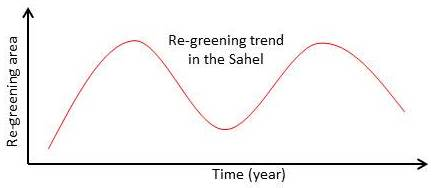
The Re-Greening of the Sahel: Natural Cyclicity or Human-Induced Change?


Abstract
:
1. Introduction
2. Materials and Methods
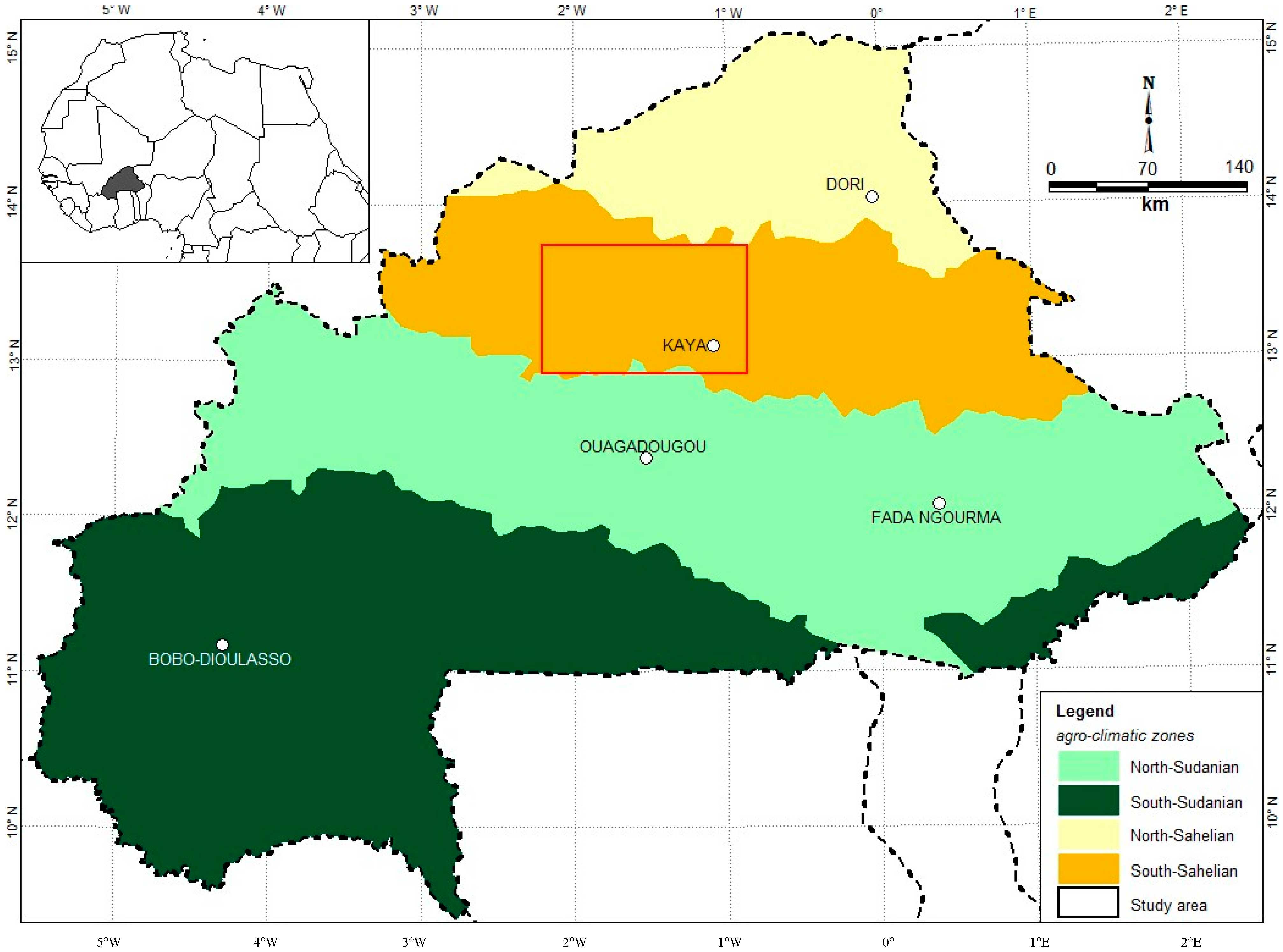
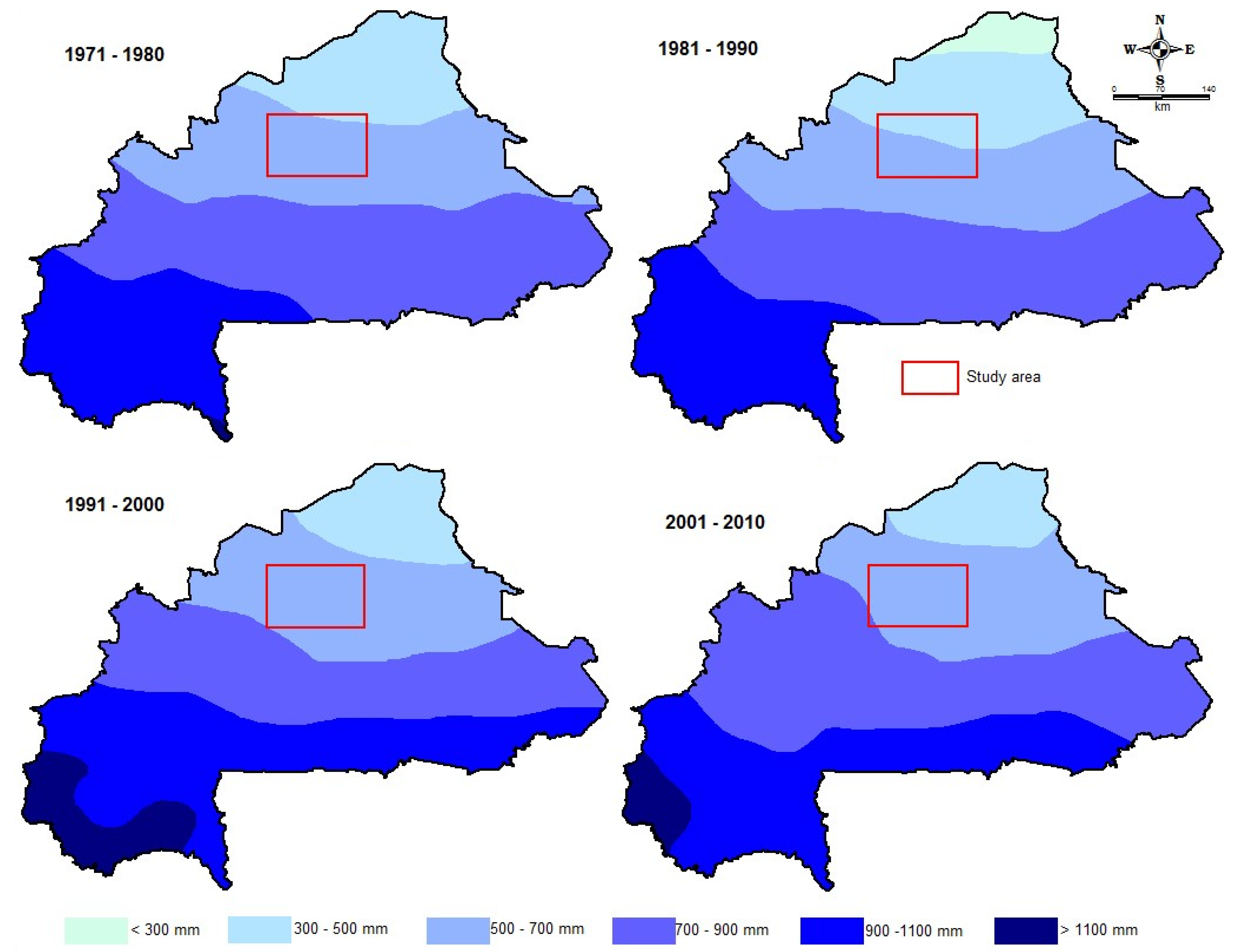
2.1. Study Area
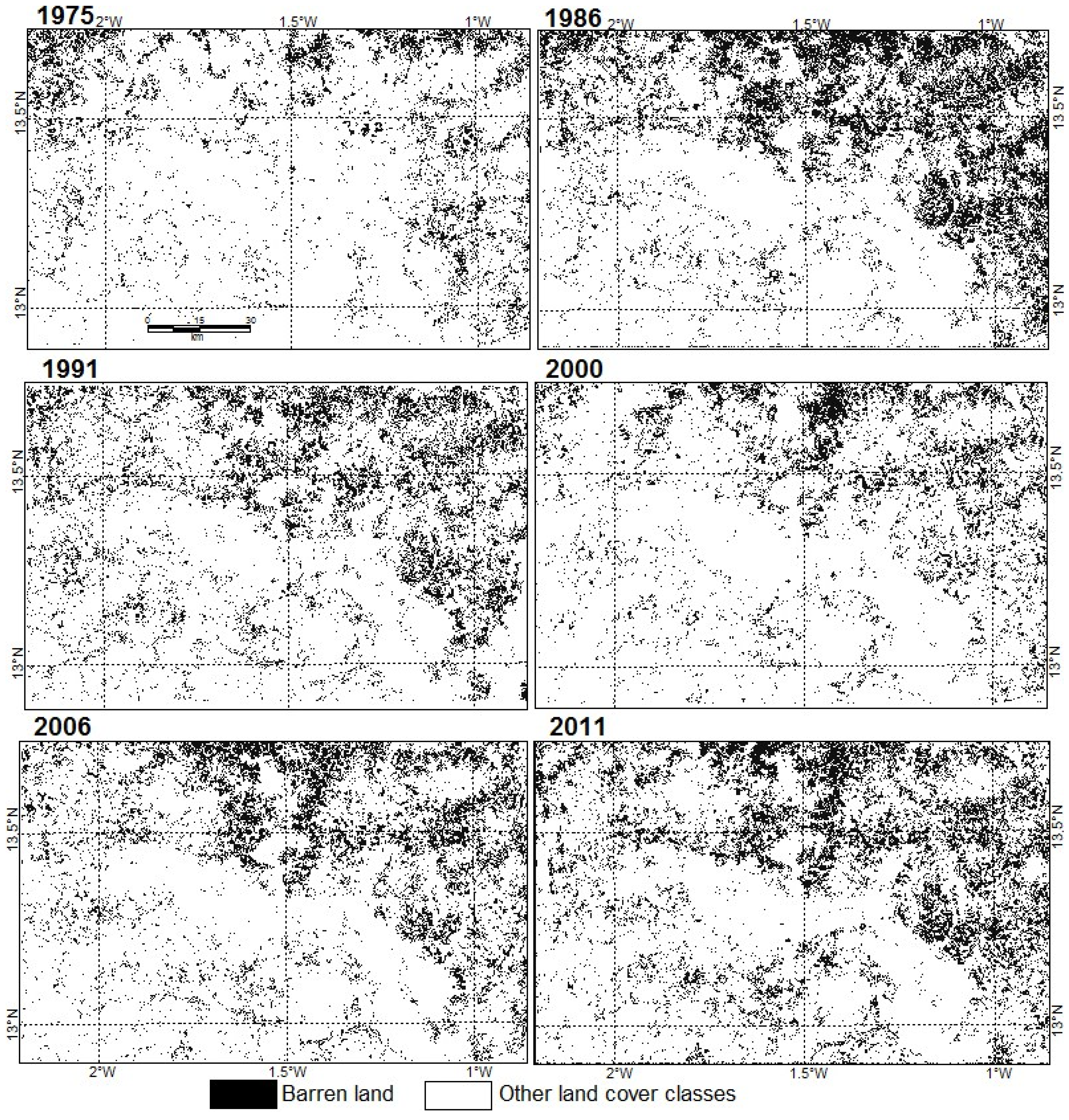
2.2. Detection of Barren Land

| Scene Reference | Satellite | Date of Acquisition | Resolution |
|---|---|---|---|
| p210r51_2m19751125 | Landsat MSS | 25 November 1975 | 68 m × 83 m |
| p195r51_5t861118 | Landsat MSS | 18 November 1986 | 68 m × 83 m |
| L4195051_05119910108 | Landsat TM | 8 January 1991 | 30 m |
| L71195051_05120001218 | Landsat TM | 18 December 2000 | 30 m |
| L5195051_05120061109 | Landsat TM | 9 November 2006 | 30 m |
| L5195051_05120110208 | Landsat TM | 8 February 2011 |
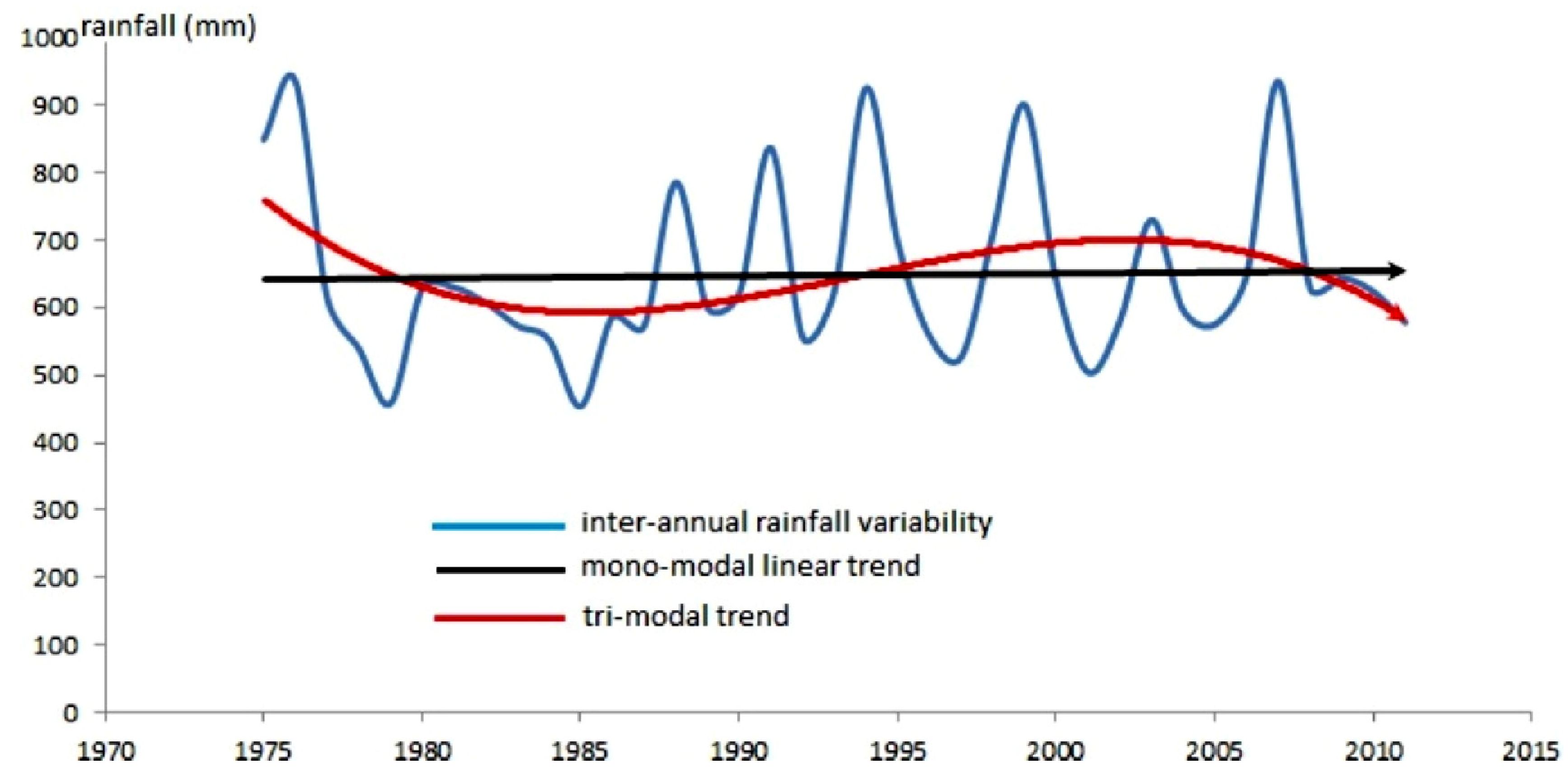
2.3. Rainfall Data
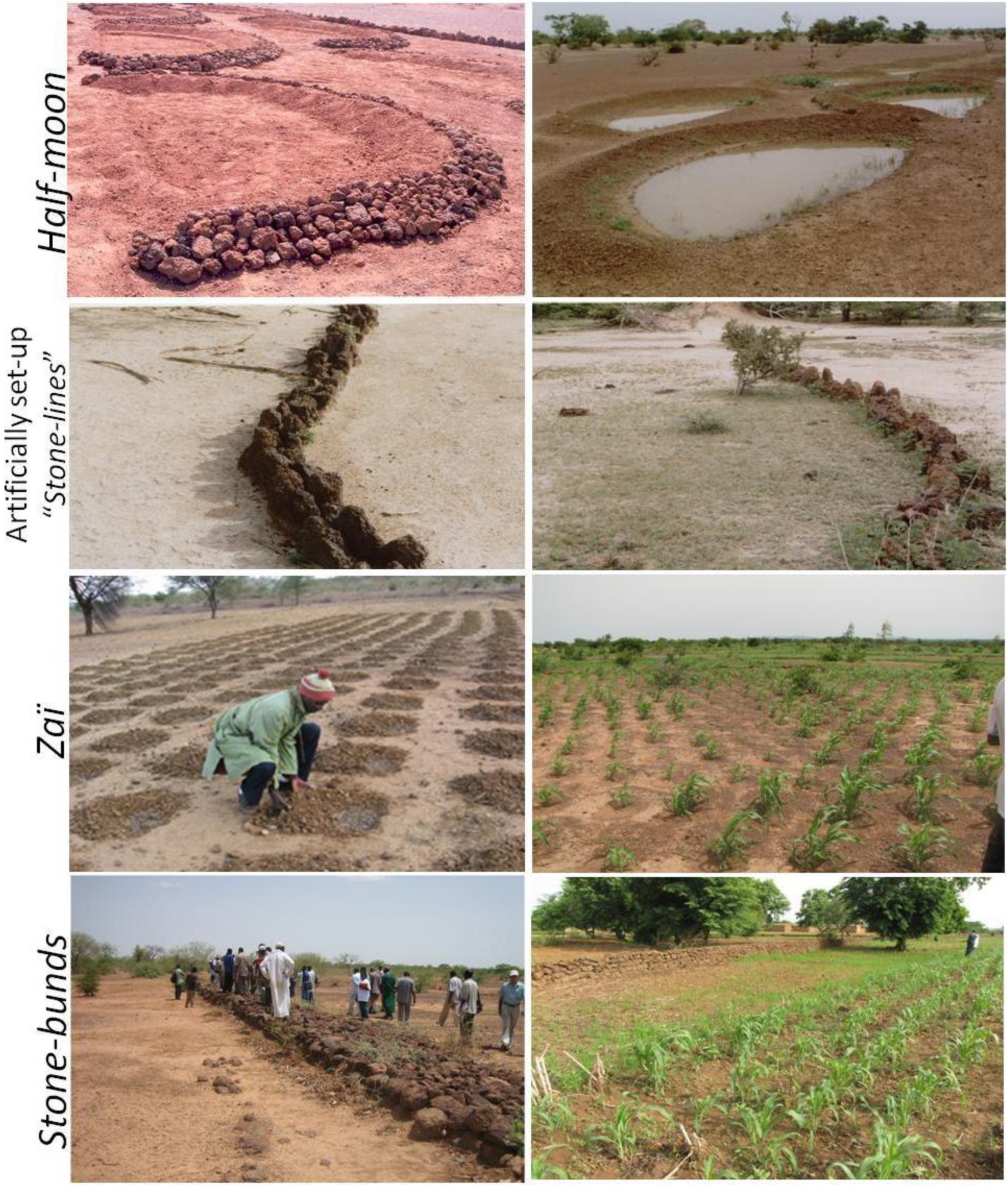
2.4. Field Observations and Discussion with Land Managers
3. Results
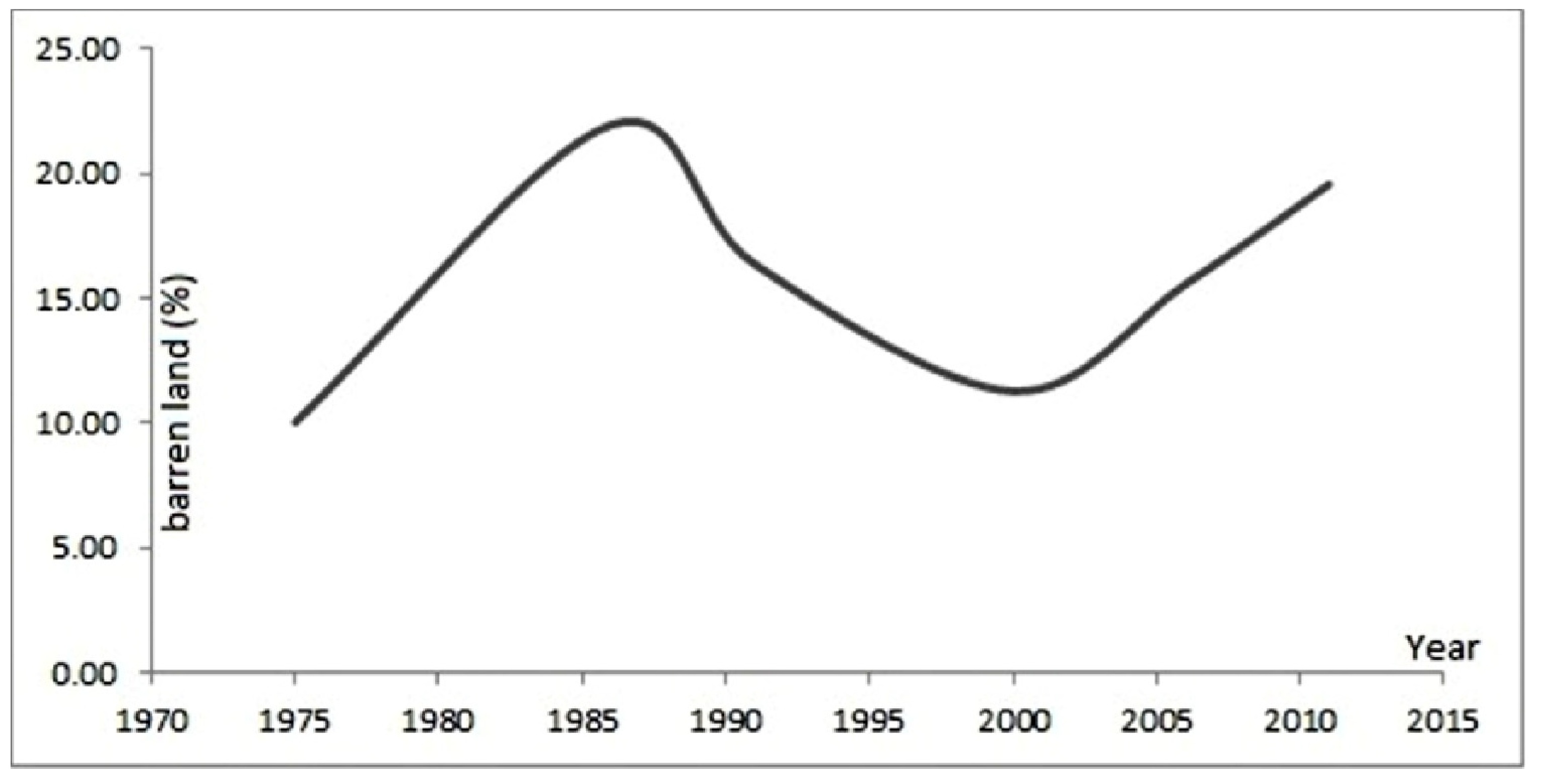
3.1. Changes in Barren Land Area

3.2. Rainfall Variability
3.3. Land Management Practices
4. Discussion
5. Conclusions
Acknowledgments
Author Contributions
Conflicts of Interest
References
- Charney, J.G. Dynamics of deserts and drought in the Sahel. Quart. J. Roy. Met. Soc. 1975, 101, 193–202. [Google Scholar] [CrossRef]
- Michetti, M.; Zampieri, M. Climate-human-land interactions: A review of major modelling approaches. Land 2014, 3, 793–833. [Google Scholar] [CrossRef]
- Brovkin, V.; Claussen, M.; Petoukhov, V.; Ganopolski, A. On the stability of the atmosphere-vegetation system in the Sahara/Sahel region. J. Geophys. Res. 1998, 103, 31613–31624. [Google Scholar] [CrossRef]
- Claussen, M.; Gayler, V. The greening of the Sahara during the mid-Holocene: Results of an interactive atmosphere-biome model. Glob. Ecol. Biogeogr. Lett. 1997, 6, 369–377. [Google Scholar] [CrossRef]
- Claussen, M.; Kubatzki, C.; Brovkin, V.; Ganopolski, A.; Hoelzmann, P.; Pachur, H.J. Simulation of an abrupt change in Saharan vegetation at the end of the mid-Holocene. Geophys. Res. Lett. 1999, 24, 2037–2040. [Google Scholar]
- Gray, L.C. Is land being degraded? A multi-scale investigation of landscape change in southwestern Burkina Faso. Land Degrad. Dev. 1999, 10, 329–343. [Google Scholar] [CrossRef]
- Ouedraogo, I.; Tigabu, M.; Savadogo, P.; Compaoré, H.; Oden, P.C.; Ouadba, J.M. Land cover change and its relation with population dynamics in Burkina Faso, West Africa. Land Degrad. Dev. 2010. [Google Scholar] [CrossRef]
- Anyamba, A.; Tucker, C.J. Analysis of Sahelian vegetation dynamics using NOAA-AVHRR NDVI data from 1981 to 2003. J. Arid Environ. 2005, 63, 596–614. [Google Scholar] [CrossRef]
- Hickler, T.; Eklundh, L.; Seaquist, J.W.; Smith, B.; Ardö, J.; Olsson, L.; Sykes, M.T.; Sjöström, M. Precipitation controls Sahel greening trend. Geogr. Res. Lett. 2005, 32. [Google Scholar] [CrossRef]
- Dardel, C.; Kergoat, L.; Hiernaux, P.; Mougin, E.; Grippa, M.; Tucker, C.J. Re-greening Sahel: 30 years of remote sensing data and field observations (Mali, Niger). Remote Sens. Environ. 2014, 140, 350–364. [Google Scholar] [CrossRef]
- Fensholt, R.; Langanke, T.; Rasmussen, K.; Reenberg, A.; Prince, S.D.; Tucker, C.; Scholes, R.J.; Le, Q.B.; Bondeau, A.; Eastman, R.; et al. Greenness in semi-arid areas across the globe 1981–2007—An Earth observing satellite based analysis of trends and drivers. Remote Sens. Environ. 2012, 121, 144–158. [Google Scholar] [CrossRef]
- Huber, S.; Fensholt, R.; Rasmussen, K. Water availability as the driver of vegetation dynamics in the African Sahel from 1982 to 2007. Glob. Planet. Change 2011, 76, 186–195. [Google Scholar] [CrossRef]
- Herrmann, S.M.; Anyamba, A.; Tucker, C.J. Recent trends in vegetation dynamics in the African Sahel and their relationship to climate. Glob. Environ. Change 2005, 15, 394–404. [Google Scholar] [CrossRef]
- Herrmann, S.M.; Tappan, G.G. Vegetation impoverishment despite greening: A case study from central Senegal. J. Arid Environ. 2013, 90, 55–66. [Google Scholar] [CrossRef]
- Olsson, L.; Eklundh, L.; Ardö, J. A recent greening of the Sahel—Trends, patterns and potential causes. J. Arid Environ. 2005, 63, 556–566. [Google Scholar] [CrossRef]
- Seaquist, J.W.; Hickler, T.; Eklundh, L.; Ardö, J.; Heumann, B.W. Disentangling the effects of climate and people on Sahel vegetation dynamics. Biogeosci. Discuss. 2008, 5, 3045–3067. [Google Scholar] [CrossRef]
- Sop, T.K.; Oldeland, J. Local perception of wood vegetation dynamics in the context of a “green Sahel”: A case study from Burkina Faso. Land Degrad. Dev. 2013, 24, 511–527. [Google Scholar] [CrossRef]
- Hiernaux, P.; Diarra, L.; Trichon, V.; Mougin, E.; Soumaguel, N.; Baup, F. Woody plant population dynamics in response to climate changes from 1984 to 2006 in Sahel (Gourma, Mali). J. Hydrol. 2009, 375, 103–113. [Google Scholar] [CrossRef] [Green Version]
- Ahmedou, O.C.A.; Nagasawa, R.; Osman, A.E.; Hattori, K. Rainfall variability and vegetation dynamics in the Mauritanian Sahel. Clim. Res. 2008, 38, 75–81. [Google Scholar] [CrossRef]
- Botoni, E.; Reij, C. La Transformation Silencieuse de l’Environnement et des Systèmes de Production au Sahel: Impacts des Investissements Publics et Privés Dans la Gestion des Ressources Naturelles; Vrije Universiteit Amsterdam (VUA) and Comité permanent Inter-Etats de Lutte contre la Secheresse dans le Sahel (CILSS): Amsterdam, The Netherland, 2009. [Google Scholar]
- Kaboré, D.; Reij, C. The Emergence and Spreading of an Improved Traditional Soil and Water Conservation Practice in Burkina Faso; The International Food Policy Research Institute (IFPRI): Washington, DC, USA, 2004. [Google Scholar]
- Reij, C.; Tappan, G.; Belemvire, A. Changing land management practices and vegetation on the Central Plateau of Burkina Faso (1968–2002). J. Arid Environ. 2005, 63, 642–659. [Google Scholar] [CrossRef]
- Reij, C.; Tappan, G.; Smale, M. Agroenvironmental transformation in the Sahel: Another kind of “Green Revolution”; The International Food Policy Research Institute (IFPRI): Washington, DC, USA, 2009. [Google Scholar]
- Sendzimir, J.; Reij, C.P.; Magnuszewski, P. Rebuilding resilience in the Sahel: Regreening in the Maradi and Zinder regions of Niger. Ecol. Soc. 2011, 16, 1. [Google Scholar]
- Brandt, M.; Verger, A.; Diouf, A.; Baret, F.; Samimi, C. Local vegetation trends in the Sahel of Mali and Senegal using long time series FAPAR satellite products and field measurement (1982–2010). Remote Sens. 2014, 6, 2408–2434. [Google Scholar] [CrossRef]
- Brandt, M.; Grau, T.; Mbow, C.; Samimi, C. Modeling soil and woody vegetation in the Senegalese Sahel in the context of environmental change. Land 2014, 3, 770–792. [Google Scholar] [CrossRef]
- Boulet, R. Notice et Carte des Ressources en sol de la Haute-Volta; ORSTOM: Paris, France, 1976. [Google Scholar]
- Chevallier, P.; Valentin, C. Influence des micro-organisations pelliculaires superficielles sur l’infiltrabilité d’un type de sol Sahélien. Bull. du GFHN 1984, 17, 9–22. [Google Scholar]
- Traoré, S.; Anne, C.A.T. Soils. In Biodiversity Atlas of West Africa; Thiombiano, A., Kampmann, D., Eds.; Biota: Frankfurt, German, 2010; pp. 130–133. [Google Scholar]
- Rasmussen, L.V.; Reenberg, A. Land use rationales in desert fringe agriculture. Appl. Geogr. 2012, 34, 595–605. [Google Scholar] [CrossRef]
- Fontes, J.; Guinko, S. Carte de Végétation et de l’Occupation du sol du Burkina Faso; Université de Toulouse: Toulouse, France, 1995. [Google Scholar]
- Le Houerou, H.N. The rangelands of the Sahel. J. Range Manag. 1980, 33, 41–46. [Google Scholar] [CrossRef]
- Institut National des Statistiques et de la Démographie (INSD). Résultats Préliminaires du Recensement Général de la Population et de l’Habitat de 2006; Direction de la Démographie-INSD: Ouagadougou, Burkina Faso, 2007. [Google Scholar]
- Ouedraogo, I. Land Use Dynamics and Demographic Change in Southern Burkina Faso. Ph.D. Thesis, Swedish University of Agricultural Sciences, Alnarp, Sweden, 2010. [Google Scholar]
- Ouedraogo, I.; Ouattara, K.; Kaboré/Sawadogo, S.; Paré, S.; Barron, J. Permanent internal migration as response to food shortage: Implication to ecosystem services in Southern Burkina Faso. In Food Production: Approaches, Challenges and Tasks; Aladjadjiyan, A., Ed.; InTech: Rijeka, Croatia, 2012; pp. 41–54. [Google Scholar]
- Ouedraogo, I.; Savadogo, P.; Tigabu, M.; Cole, R.; Odén, P.C.; Ouadba, J.M. Is rural migration a threat to environmental sustainability in southern Burkina Faso? Land Degrad. Dev. 2009, 20, 217–230. [Google Scholar] [CrossRef]
- Reij, C.; Tappan, G.; Smale, M. Chapter 7. Re-greening the Sahel: Farmer-led innovation in Burkina Faso and Niger. In Millions Fed: Proven Successes in Agricultural Development; International Food Policy Research Institute (IFPRI): Washington, DC, USA, 2009; pp. 53–58. [Google Scholar]
- Thiombiano, L. Etude de l’Importance des Facteurs Edaphiques et Pédopaysagiques Dans le Développement de la Désertification en zone Sahélienne du Burkina Faso. Ph.D. Thesis, Université de Cocody, Abidjan, Côte d’Ivoire, 2000. [Google Scholar]
- Crist, E.P.; Cicone, R.C. Application of the Tasseled Cap concept to simulated thematic mapper data. Photogramm. Eng. Remote Sens. 1984, 50, 343–352. [Google Scholar]
- Gray, L.C. What kind of intensification? Agricultural practice, soil fertility and socioeconomic differentiation in rural Burkina Faso. Geogr. J. 2005, 171, 70–82. [Google Scholar] [CrossRef]
- Traoré, S.; Tom, O. Dirty droughts causing loss and damage in northern Burkina Faso. Int. J. Glob. Warm. 2013, 5, 498–513. [Google Scholar] [CrossRef]
- Eklundh, L.; Olsson, L. Vegetation index trends for the African Sahel 1982–1999. Geophys. Res. Lett. 2003, 30, 1430. [Google Scholar] [CrossRef]
- Slingerland, M.A.; Stork, V.E. Determinants of the practice of Zai and mulching in North Burkina Faso. J. Sustain. Agric. 2000, 16, 53–76. [Google Scholar] [CrossRef]
- Sorgho, M.M.; Sylvain, K.; Karim, T. Burkina Faso: The Zai Technique and Enhanced Agricultural Productivity; IK Notes No.80; The World Bank: Ouagadougou, Burkin Faso, 2005; p. 4. [Google Scholar]
- Douxchamps, S.; Ayantunde, A.; Barron, J. Taking stock of forty years of agricultural water management interventions in smallholder systems of Burkina Faso. Water Resour. Rural Dev. 2014, 3, 1–13. [Google Scholar] [CrossRef]
- Rasmussen, L.V.; Rasmussen, K.; Reenberg, A.; Proud, S. A system dynamics approach to land use changes in agro-pastoral systems on the desert margins of Sahel. Agric. Syst. 2012, 107, 56–64. [Google Scholar] [CrossRef]
- Youl, S.; Barbier, B.; Moulin, C.H.; Manlay, R.J.; Botoni, E.; Masse, D.; Hien, V.; Feller, C. Modélisation empirique des principaux déterminents socio-économiques de la gestion des exploitations agricoles au sud-ouest du Burkina Faso. Biotechnol. Agron. Soc. Environ. 2008, 12, 9–21. [Google Scholar]
- Brandt, M.; Romankiewicz, C.; Spiekermann, R.; Samimi, C. Environmental change in time series—An interdisciplinary study in the Sahel of Mali and Senegal. J. Arid Environ. 2014, 105, 52–63. [Google Scholar] [CrossRef]
- Dasylva, S.; Cosandey, C.; Sambou, S. Acuité des problèmes lies à l’eau et la nécessité d’une gestion intégrée des eaux pluviales dans la Région de Dakar. In Proceedings of Colloque Développement Durable: Leçons et Perspectives, Ouagadougou, Burkina Faso, 1–4 June 2004.
- Reenberg, A.; Maman, I.; Bouzou Moussa, I.; Fog, B. Land saturation in SE Niger: Triangulating qualitative and quantitative information for critical assessment of land use trajectories. Land 2013, 2, 508–533. [Google Scholar] [CrossRef]
- Nicholson, S.E. Recent rainfall fluctuations in Africa and their relationshipto past conditions over the continent. Holocene 1994, 4, 121–131. [Google Scholar] [CrossRef]
- Nicholson, S.E. The West African Sahel: A Review of Recent Studies on the Rainfall Regime and Its Interannual Variability. ISRN Meteorol. 2013, 2013, 453521. [Google Scholar] [CrossRef]
- Traoré, K.; Toé, A.M. Capitalisation des Initiatives sur les Bonnes Pratiques Agricoles au Burkina Faso; Ministère de l’Agriculture, de l’Hydraulique et des Ressources Halieutiques (MAHRH): Ouagadougou, Burkina Faso, 2008. [Google Scholar]
© 2014 by the authors; licensee MDPI, Basel, Switzerland. This article is an open access article distributed under the terms and conditions of the Creative Commons Attribution license (http://creativecommons.org/licenses/by/3.0/).
Share and Cite
Ouedraogo, I.; Runge, J.; Eisenberg, J.; Barron, J.; Sawadogo-Kaboré, S. The Re-Greening of the Sahel: Natural Cyclicity or Human-Induced Change? Land 2014, 3, 1075-1090. https://doi.org/10.3390/land3031075
Ouedraogo I, Runge J, Eisenberg J, Barron J, Sawadogo-Kaboré S. The Re-Greening of the Sahel: Natural Cyclicity or Human-Induced Change? Land. 2014; 3(3):1075-1090. https://doi.org/10.3390/land3031075
Chicago/Turabian StyleOuedraogo, Issa, Jürgen Runge, Joachim Eisenberg, Jennie Barron, and Séraphine Sawadogo-Kaboré. 2014. "The Re-Greening of the Sahel: Natural Cyclicity or Human-Induced Change?" Land 3, no. 3: 1075-1090. https://doi.org/10.3390/land3031075
APA StyleOuedraogo, I., Runge, J., Eisenberg, J., Barron, J., & Sawadogo-Kaboré, S. (2014). The Re-Greening of the Sahel: Natural Cyclicity or Human-Induced Change? Land, 3(3), 1075-1090. https://doi.org/10.3390/land3031075