Article

Accessibility Evaluation and Educational Implications for Ecological Civilization Education Fields: A Case Study of the Tibet Autonomous Region, China


1
State Key Laboratory of Regional Environment and Sustainability, School of Environment, Beijing Normal University, Beijing 100875, China
2
School of Geographic Sciences, East China Normal University, Shanghai 200241, China
*
Author to whom correspondence should be addressed.
These authors contributed equally to this work.
Land 2026, 15(8), 1389; https://doi.org/10.3390/land15081389
Submission received: 18 June 2026 / Revised: 28 July 2026 / Accepted: 29 July 2026 / Published: 2 August 2026
(This article belongs to the Special Issue Feature Papers for "Landscape Ecology" Section (Second Edition))

Abstract

Ecological civilization education has become an important component of environmental education and sustainable development strategies in China. Field-based learning in real ecological environments is essential for helping students understand ecological processes and human–environment relationships. However, limited attention has been paid to whether schools can spatially access ecological learning sites within feasible travel-time ranges, especially in plateau and mountainous regions where transportation constraints are strong. From the perspective of ecosystem service flow, forest parks can be regarded as supply sites of ecological learning services, secondary schools as demand sites, and road networks as the pathways through which such services are transformed into actual educational opportunities. To address this gap, this study evaluates the accessibility of forest-park-based ecological learning resources for secondary schools in the Tibet Autonomous Region, China. Taking 11 national forest parks and 137 secondary schools as research objects, a network-based travel-time model was constructed using road network data, and 1 h, 3 h, and 6 h service areas were generated to assess forest park service capacity and school accessibility. The results show that forest park educational service capacity is highly uneven. Nimu, Jiedexiu, and Caina Forest Parks have the highest service capacity, each covering more than 60 secondary schools within 6 h, while nearly half of the parks show relatively limited coverage. School accessibility also presents a clear core–periphery pattern, with high-accessibility schools concentrated around Lhasa and nearby transport corridors, whereas many schools in western and northern Tibet remain outside the 6 h service range. Based on the accessibility levels, differentiated field education strategies are proposed, including short field observation, one-day field trips, cross-regional fieldwork, and virtual or school-based alternatives. This study provides a spatial analytical framework for understanding the flow of ecological learning services from forest parks to schools and offers evidence for optimizing geography field education and improving equitable access to ecological civilization education in mountainous regions.

1. Introduction

China has experienced rapid urbanization, accompanied by the continued expansion of urban agglomerations and the increasing concentration of population and socioeconomic activities [1]. This process has substantially transformed land-use patterns and intensified concerns regarding ecological degradation and biodiversity conservation, highlighting the need to better integrate urban development with ecological planning [2]. Against this background, ecological civilization construction has become a core national strategy in China, integrating environmental protection, sustainable development, and education reform [3,4,5]. Within this framework, ecological civilization education has been increasingly emphasized as an important pathway to cultivate environmental literacy, spatial thinking, and human–nature awareness among students [4,5]. However, despite its policy importance, ecological education in schools is still predominantly delivered through classroom-based instruction, which limits students’ direct engagement with natural environments. This is a critical limitation because ecological learning is inherently experiential and place-based, requiring direct interaction with ecosystems to fully understand ecological processes and human–environment relationships [6,7]. Recent studies in outdoor learning and environmental education consistently demonstrate that field-based learning significantly enhances students’ cognitive understanding, environmental awareness, and socio-emotional development compared to classroom-only instruction [6,7,8]. However, access to outdoor learning environments is spatially uneven, and schools often face constraints such as safety requirements, supervision capacity, transportation conditions, and the need to complete field activities within limited time (e.g., one-day round trips). As a result, spatial accessibility has become a key determinant of whether ecological education can be effectively implemented outside the classroom [8,9]. Therefore, assessing the accessibility between schools and ecological sites is essential for translating ecological education policies into practical learning opportunities.
Recent studies on outdoor learning and nature-based education have highlighted the importance of natural environments in supporting students’ experiential learning, environmental awareness, and place-based understanding [6]. Forest parks, scenic areas, and other natural landscapes are also widely recognized as important spatial carriers for recreation, tourism experience, and informal learning activities [10,11]. In parallel, accessibility analysis has become a fundamental approach in geography and spatial planning for evaluating the ease of reaching spatially distributed resources under real transportation constraints [12]. This approach has been widely applied in studies of park green spaces and public facilities to identify spatial disparities in resource access and service provision [13]. However, existing studies mainly focus on tourism development, recreational behavior, or urban service equity, while limited attention has been given to the accessibility relationship between educational institutions and natural environments for field-based learning purposes. Therefore, further research is needed to integrate accessibility analysis into outdoor education contexts in order to better understand how spatial constraints influence the feasibility of geography field-based education.
Because accessibility analysis emphasizes the spatial linkage among resource locations, potential users, and connecting pathways, its analytical logic is closely related to the concept of ecosystem service flow. Ecosystem service flow refers to the process through which ecosystem services are transferred from ecological supply areas to human demand areas and are ultimately perceived, accessed, or used by beneficiaries [14]. For recreation-related ecosystem services, this process is particularly dependent on spatial mobility because the realization of recreational value requires not only the existence of ecological resources but also actual visits, experiences, and interactions with natural spaces [10,15]. Existing studies have further shown that recreational ecosystem services are closely associated with human well-being, cultural experience, and practical landscape governance, while mismatches between supply and demand may reduce the effective use of such services [16]. In outdoor recreation management, coordinating recreational supply and demand has also been regarded as important for improving conservation, health, and accessibility outcomes [17]. In the context of field-based geography education, forest parks can therefore be regarded as the supply areas of recreation and ecological learning services, secondary schools as the demand areas, and road networks as the flow pathways connecting the two. Moreover, in mountainous ecological regions, landscape connectivity strongly shapes the organization of ecological spaces and the possibility of human–nature interaction [18]. Accordingly, introducing ecosystem service flow into accessibility analysis helps reinterpret school–forest park accessibility not merely as a transportation issue but as a spatial process through which ecological resources are transformed into practical geography field-education opportunities.
The conceptual framework links three complementary bodies of scholarship. Place-based and field-based geography education explains the pedagogical value of direct engagement with landscapes and human–environment relationships, while research on nature-specific outdoor learning emphasizes that learning outcomes depend on the setting and the way outdoor experiences are organized [19]. The cultural ecosystem service perspective identifies experiential, interpretive, recreational, and educational benefits that people obtain through interaction with ecological environments, whereas recent ecosystem service research distinguishes potential supply from flow and actual use [20]. Integrating these perspectives, this study treats educational opportunity as a relational outcome among ecological resource supply, school demand, and the spatial pathway that enables students and teachers to reach and use natural sites. Accessibility is therefore interpreted as a necessary spatial condition for place-based ecological learning, rather than as a complete measure of actual educational participation.
Tibet provides a particularly suitable empirical context for examining the accessibility of forest-park-based geography field education. As an ecologically important plateau region, it supports diverse ecosystems and key ecological functions, while its high-altitude terrain and uneven transportation network create substantial spatial constraints on the educational use of ecological resources [21,22,23]. Against this background, this study takes national forest parks and secondary schools in Tibet as the research objects, constructs a network-based travel-time accessibility model, and evaluates both forest park service capacity and school accessibility. The purpose is to identify spatial mismatches between ecological learning resources and educational demand and to provide spatial evidence for differentiated geography field-education planning.
Accordingly, this study makes three contributions. Conceptually, it extends the ecosystem service flow perspective to geography field education by explicitly linking ecological learning-resource supply, school demand, and network-constrained connections. Methodologically, it combines a supply-side assessment of how many schools each park can potentially serve with a demand-side assessment of each school’s minimum travel time to the park system. From an applied perspective, it translates the resulting accessibility structure into differentiated field-education strategies, providing a transferable framework for diagnosing spatial mismatches between ecological learning resources and educational demand in geographically constrained regions.
In this study, educational implications are organized across three linked dimensions. The first concerns teaching organization: accessibility conditions can inform differentiated combinations of inquiry-based, project-based, place-responsive, and hybrid field–virtual learning. The second concerns curriculum integration: field activities can be organized as sequenced pre-field preparation, on-site investigation, and post-field analysis that connect geography with ecology, environmental science, and civic inquiry. The third concerns assessment and organizational support: learning can be documented through field notebooks, portfolios, maps, group reports, and reflective tasks, while implementation may be supported through teacher preparation, risk planning, park–school collaboration, and shared regional facilities. Accessibility analysis does not demonstrate that these educational practices are already implemented; rather, it provides spatial evidence for identifying feasible educational options under different geographic constraints.

2. Materials and Methods

2.1. Study Area

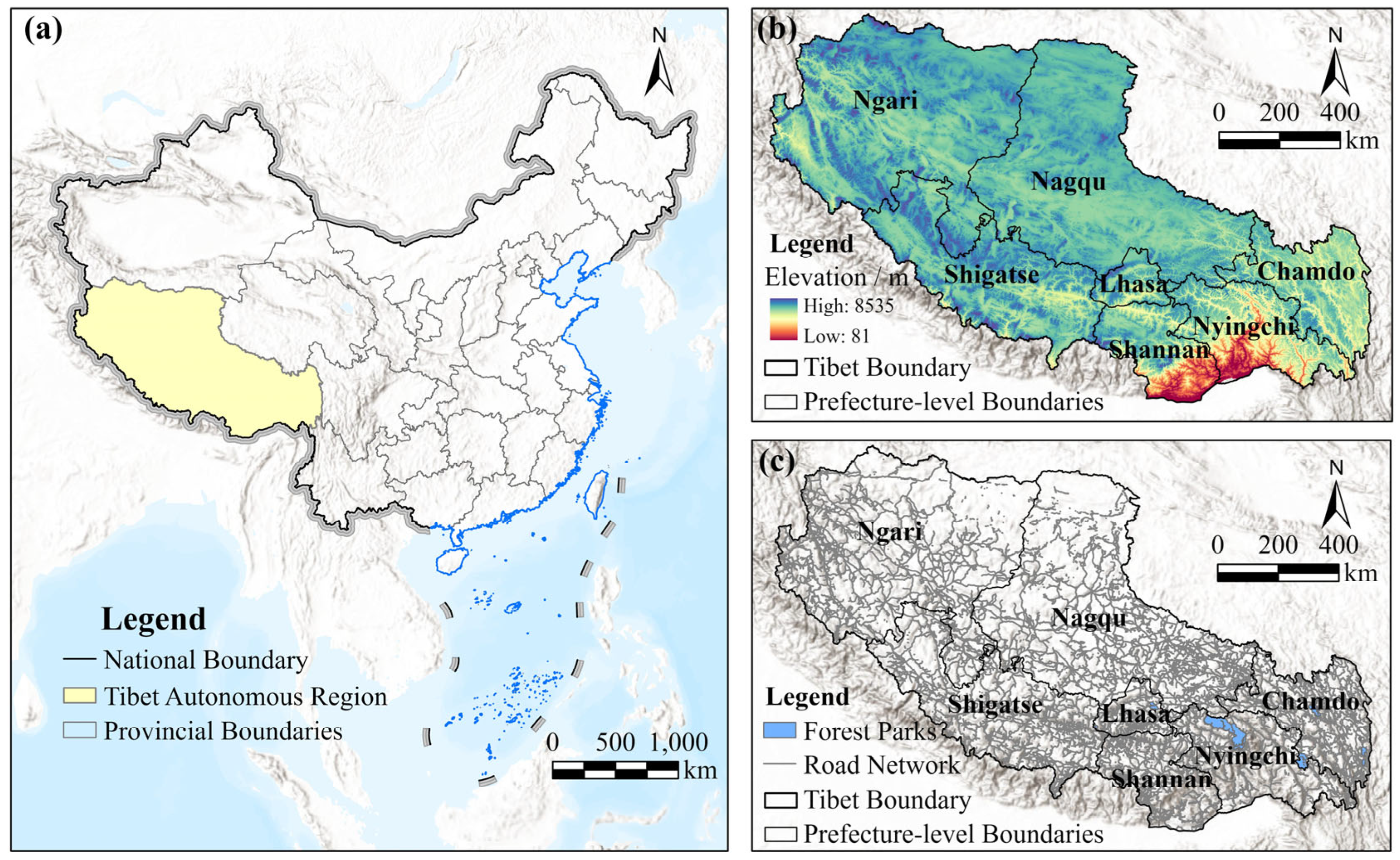
The Tibet Autonomous Region is located in southwestern China and occupies the main part of the Qinghai–Tibet Plateau (Figure 1a). It covers approximately 1.22 million km2 and is characterized by high elevation, complex terrain, large topographic gradients, and fragile plateau ecosystems (Figure 1b). The region includes extensive mountains, valleys, forests, wetlands, grasslands, and river systems, forming an important ecological security barrier in China and supporting key ecosystem functions such as water conservation, biodiversity maintenance, climate regulation, and soil conservation [21,22]. These geographical and ecological characteristics make Tibet a representative region for examining the relationship between ecological resources and educational use.
In this study, national forest parks in Tibet were selected as ecological learning resource sites (Figure 1c). Forest parks integrate natural landscapes, forest ecosystems, recreational functions, and environmental interpretation, making them suitable spatial carriers for geography field education and ecological civilization education. Secondary schools were selected as the educational demand points because they are directly related to geography curriculum implementation and field-based learning activities. However, Tibet’s high-altitude terrain and uneven road network conditions create considerable spatial constraints for schools attempting to use forest parks as outdoor learning sites [23]. Therefore, evaluating the travel-time accessibility between secondary schools and national forest parks can help identify which schools are able to access ecological learning resources within feasible field-trip time thresholds.
This study focuses on 11 national forest parks and 137 secondary schools in Tibet. Based on the road network, travel-time service areas were constructed to evaluate the spatial service ranges of each forest park for geography field education. The study area provides a typical plateau context for exploring how ecological resources, school demand, and transportation conditions jointly shape the feasibility of field-based geography education.

2.2. Data Sources

The data used in this study mainly include administrative boundary data, national forest park data, secondary school data, and road network data. Administrative boundary data for the Tibet Autonomous Region and its prefecture-level units were obtained from the National Catalogue Service for Geographic Information (https://www.webmap.cn/) and were used to define the study area and support cartographic visualization. National forest park data were compiled from official information published by the National Forestry and Grassland Administration (https://www.forestry.gov.cn/) and the People’s Government of the Tibet Autonomous Region (https://www.xizang.gov.cn/). These data were used to represent the supply side of ecological learning resources, including 11 forest parks in Tibet. Secondary school data were obtained from Point of Interest (POI) datasets provided by the Amap Open Platform (https://lbs.amap.com/) and comprised a total of 137 secondary schools. These data represent the demand side of geography field education and cover junior secondary schools, senior secondary schools, complete secondary schools, nine-year schools, and twelve-year schools. Each school was geocoded and verified to ensure spatial accuracy before analysis. Road network data were obtained from OpenStreetMap (OSM; https://www.openstreetmap.org/) and used to construct the travel-time-based accessibility model. All spatial datasets were checked, standardized, and projected into a unified coordinate system before analysis. Spatial data processing, network accessibility analysis, service area calculation, and map visualization were conducted using ArcGIS Pro 3.0.2 with the Network Analyst extension (Esri, Redlands, CA, USA). To improve network consistency, OSM road classes were standardized before impedance assignment, and school and park access points were connected to reachable road-network locations before service-area analysis. The model is therefore intended as a regional-scale estimate of potential spatial accessibility. No region-wide dataset of observed school field trips, GPS travel times, or administrative trip records was available for external behavioral validation. The selected park access points represent the road-network entrances at which external travel is considered complete. Therefore, the modeled travel time covers the school-to-park access stage but does not include movement from the entrance through internal park roads or trails to specific ecological teaching sites. This boundary is made explicit so that the service areas are interpreted as external network accessibility rather than complete door-to-learning-site travel time.

2.3. Research Framework

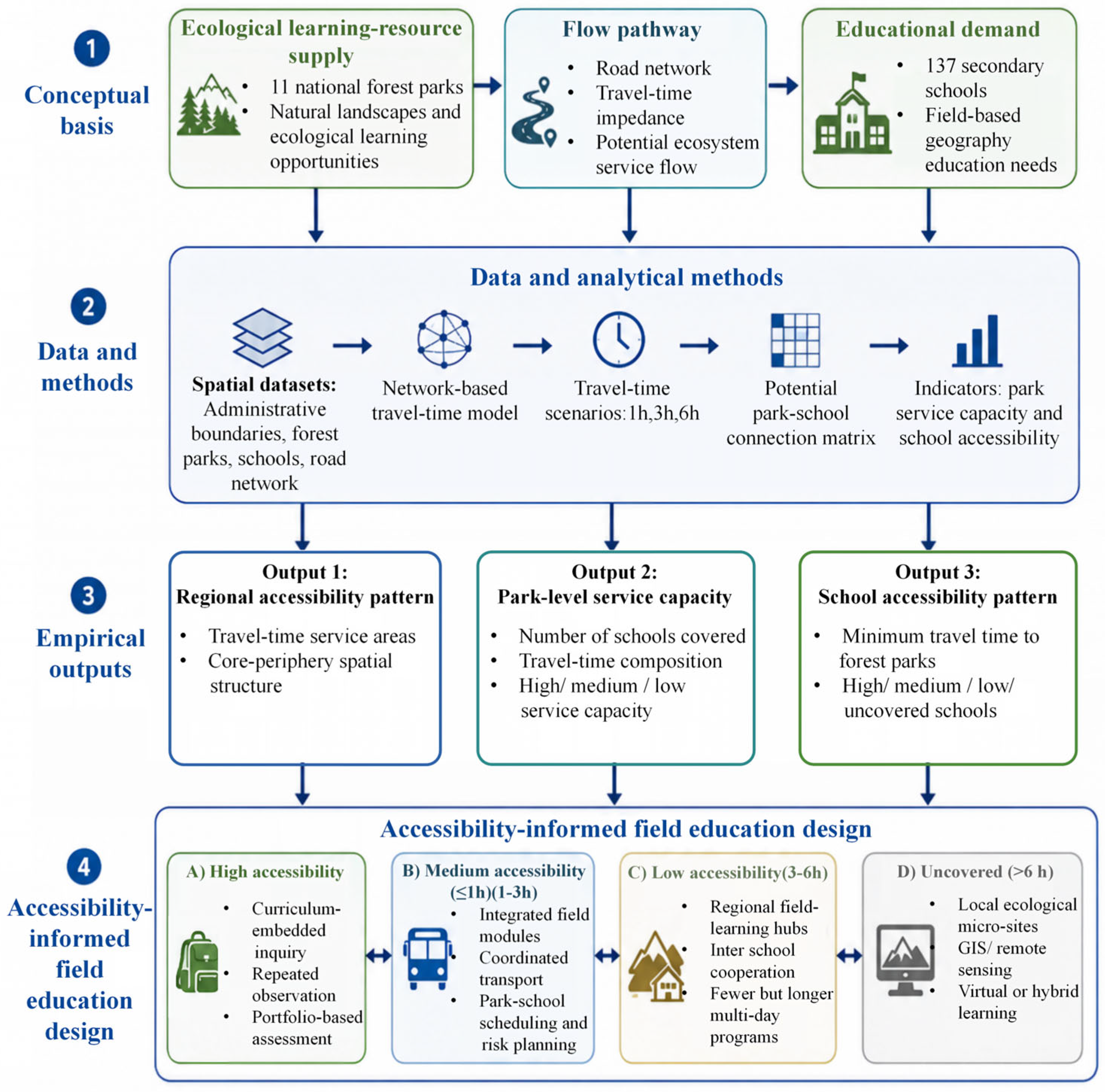
This study develops a four-stage conceptual and analytical framework linking ecological learning-resource supply, network-constrained potential service flows, empirical accessibility evaluation, and differentiated geography field-education design (Figure 2). At the conceptual level, forest parks are treated as the supply nodes of ecological learning resources, secondary schools as the demand nodes of field-based geography education, and road networks as the spatial pathways connecting supply and demand. Network travel time represents the spatial impedance constraining potential park–school connections. Accessibility is therefore interpreted as a necessary spatial condition for ecological learning opportunities rather than as evidence of actual field-trip participation or learning outcomes.
At the analytical level, administrative boundaries, forest parks, secondary schools, and road networks are integrated into a unified spatial database. A network-based travel-time model is then constructed under the 1 h, 3 h, and 6 h scenarios, from which a potential park–school connection matrix is generated. The matrix is evaluated from both the supply and demand sides. The supply-side assessment measures the number and travel-time composition of schools potentially served by each forest park, whereas the demand-side assessment identifies the minimum travel time from each school to the forest park system.
The analysis produces three complementary empirical outputs: the regional pattern of travel-time service areas, park-level educational service capacity, and school-level accessibility. Based on minimum travel time, schools are classified as having high accessibility (≤1 h), medium accessibility (1–3 h), low accessibility (3–6 h), or being uncovered (>6 h or not connected within the study threshold). These accessibility classes provide the analytical basis for differentiated field-education design, including curriculum-embedded and repeated inquiry for highly accessible schools, integrated field modules for medium-accessibility schools, regional field-learning hubs and inter-school cooperation for low-accessibility schools, and local or hybrid alternatives for uncovered schools. These strategies represent accessibility-informed educational options whose implementation additionally depends on school resources, transportation arrangements, safety, weather conditions, and institutional support.

2.4. Methods

2.4.1. Ecosystem Service Flow and Park–School Accessibility

Following the distinction among ecosystem service supply, demand, flow, and use [24,25], the park–school pair is adopted as the basic unit of analysis. For each pair, the model estimates whether a potential educational service connection can be established under a specified network travel-time threshold. The potential connection between forest park i and secondary school j is expressed as follows [14]:
E S F i j = f S i , D j , T i j
where ESFij represents the potential educational ecosystem service connection between forest park i and school j; Si represents the availability of the forest-park supply node; Dj represents the presence of the secondary-school demand node; and Tij represents the network travel-time cost between the two nodes. Because comparable park-level educational quality scores and school-level demand weights are unavailable, Si and Dj are treated as presence terms, while variation in potential connections is determined by Tij and the scenario threshold.
For a travel-time threshold t, a binary potential connection Cij(t) is assigned a value of 1 when the modeled minimum travel time Tij is less than or equal to t and 0 otherwise. Aggregation across schools provides the park-side service-capacity indicator, whereas minimization across parks provides the school-side accessibility indicator.
At the network level, the binary connection matrix is summarized using the total number of potential connections F(t), connection density R(t) = F(t)/(mn), and the increment in connections between adjacent travel-time scenarios. Here, m = 11 represents the number of forest parks, and n = 137 represents the number of secondary schools. These indicators quantify the scenario-dependent spatial possibility of educational service connections; they do not represent actual visits, participation frequency, visitor volume, or observed learning outcomes.

2.4.2. Network-Based Travel Time Accessibility Model

A network-based approach was adopted to evaluate spatial accessibility between secondary schools and national forest parks. Unlike Euclidean distance methods, the network analysis considers real-world transportation constraints, including road geometry and travel impedance [26].
The road network was modeled as a directed weighted graph, where road segments represent edges and intersections represent nodes. Travel time was assigned as the impedance weight for each edge, reflecting realistic transportation conditions in mountainous regions. The shortest path algorithm was applied to compute the minimum travel time between each forest park and secondary school using ArcGIS Network Analyst.
The travel time for each road segment is calculated as follows [27,28]:
T = L V × 60
where T is travel time (minutes), L is road length (km), and V is the assumed average travel speed (km/h) based on road type.
To make the impedance model reproducible, road-class-specific average operating speeds were assigned as follows: motorway, 80 km/h; trunk, 70 km/h; primary, 60 km/h; secondary, 50 km/h; tertiary, 40 km/h; unclassified and residential roads, 30 km/h; service roads, 20 km/h; and tracks, 15 km/h. The values are regional-scale operating assumptions rather than statutory speed limits or real-time observations. They preserve the functional hierarchy among OSM road classes while adopting conservative speeds for the plateau–mountain context. As a result, the travel-time surface should be interpreted as a static regional accessibility scenario, not as a prediction of any specific trip.
Because road conditions vary across seasons and routes, these class-based speeds are used only to establish a transparent baseline scenario. No uniform seasonal correction factor was imposed because snow, rainfall, slope failure, maintenance, and traffic regulation affect different road segments unevenly, and reliable region-wide time-specific speed data were unavailable. Classification uncertainty is expected to be greatest for park–school pairs whose modeled travel times lie close to the 1 h, 3 h, or 6 h boundaries. Accordingly, the service classes should be interpreted as planning bands rather than exact operational guarantees.
This network-based approach allows for a more realistic representation of accessibility in Tibet, where terrain complexity and road connectivity strongly influence travel efficiency.

2.4.3. Service Area Construction

Service areas were generated around each forest park to represent the spatial extent of accessible ecological learning resources within given travel-time thresholds [29]. Unlike buffer-based methods, network service areas follow actual road connectivity, ensuring that accessibility reflects real travel conditions.
The educational interpretation of the thresholds is based on a trip time-budget logic rather than on the assumption that the same cutoffs apply to every school. Let A = H − 2T − O, where A is the time remaining for on-site learning, H is the total time window available for the activity, T is one-way network travel time, and O represents loading, breaks, meals, safety checks, and other non-teaching overhead. Because H and O vary among schools, the thresholds are used as scenario bands, not as empirical universal cutoffs. The ≤1 h band indicates comparatively favorable conditions for routine or half-day use; the 1–3 h band ranges from full-day feasibility at its lower end to extended-day or overnight organization near its upper end; and the 3–6 h band is more realistically associated with multi-day or regional-hub programs. This interpretation is consistent with outdoor and place-responsive learning research emphasizing that duration, organization, and local context jointly shape implementation.
The service area for each forest park is defined as
S A i = x R 2 T i ( x ) t
where S A i denotes the service area of forest park i, T i ( x ) represents the shortest travel time from forest park i to location x, and t is the predefined travel-time threshold [30].
The “disks” and “rings” outputs generated by ArcGIS Network Analyst were used to represent cumulative and incremental accessibility zones, respectively. These outputs enable visualization of both absolute coverage and marginal accessibility expansion across different time thresholds.
The selected park access points represent the road-network entrances at which external travel is considered complete. Therefore, the modeled travel time covers the school-to-park access stage but does not include movement from the entrance through internal park roads or trails to specific ecological teaching sites. This boundary is made explicit so that the service areas are interpreted as external network accessibility rather than complete door-to-learning-site travel time.

2.4.4. Educational Service Capacity of Forest Parks

The educational service capacity of forest parks was quantified based on the number of secondary schools that can be reached within specified travel-time thresholds [31]. This indicator reflects the potential of each forest park to support geography field education and ecological civilization education.
Let N i ( t ) represent the number of schools accessible from forest park i within time threshold t:
N i ( t ) = j = 1 n I T i j t
where I() is a binary indicator function (1 if condition is satisfied, 0 otherwise), and n = 137 represents the total number of secondary schools [11].
The cumulative accessibility at 360 min was used as the primary indicator for classifying forest parks into three service capacity levels: high, medium, and low [32]. This classification reflects the spatial heterogeneity of educational ecosystem service provision under real transportation constraints in mountainous regions. For reproducible classification, the ordered 6 h coverage counts were grouped into high capacity (≥60 schools), medium capacity (10–59 schools), and low capacity (<10 schools). These thresholds are case-specific relative classes based on the distribution of the 11 parks and are used only to summarize differentiation within the present study area; they should not be interpreted as universal standards of forest-park educational capacity.

2.4.5. Accessibility Evaluation of Secondary Schools

To evaluate the accessibility of ecological learning resources for secondary education, each school was assigned a minimum travel time to the nearest forest park. This approach assumes that each school will preferentially access the closest available ecological learning site [33,34].
The minimum travel time is calculated as
T m i n ( j ) = min i F T i j
where T m i n ( j ) is the shortest travel time from school j to any forest park, F is the set of forest parks, and T i j is the travel time between forest park i and school j.
Based on T m i n ( j ) , secondary schools were classified into four accessibility categories: high (≤1 h), medium (1–3 h), low (3–6 h), and uncovered (>6 h or no reachable forest park within the study threshold). This classification reflects the feasibility of organizing geography field trips under typical school scheduling constraints, particularly the requirement for same-day return in most secondary education settings [35]. In the current analysis, each secondary school is treated as one demand node, and school-level differences in enrollment size, financial resources, teacher capacity, transportation availability, and willingness to organize field activities are not explicitly incorporated because comparable region-wide data were unavailable.

3. Results

3.1. Regional Pattern of Forest Park Travel-Time Accessibility

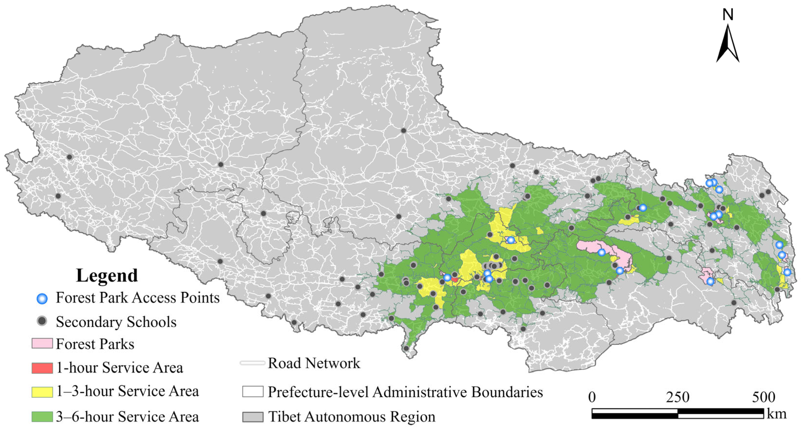
The travel-time service areas of forest parks exhibit pronounced spatial heterogeneity across Tibet, with a clear gradient from the central and southeastern regions toward the western and northwestern plateau (Figure 3). Overall, accessible zones are primarily concentrated in the Lhasa–Shannan–Nyingchi corridor, where forest parks, road networks, and secondary school distributions are relatively dense, forming a continuous accessibility belt. In contrast, northern and western Tibet remain largely outside the 6 h service range, reflecting strong constraints from sparse road infrastructure and low settlement density.
At the 1 h threshold, service areas are highly fragmented and mainly occur around forest parks located near Lhasa and parts of Shannan and Nyingchi. These areas indicate extremely limited but highly favorable conditions for short-duration field-based geography activities. The spatial concentration around Lhasa reflects the effect of administrative and transportation centrality, where both ecological resources and educational demand are relatively clustered.
The 1–3 h service areas expand significantly and form several distinct accessibility clusters. The most prominent cluster is located around Lhasa and surrounding counties, where high road density and school concentration enable one-day field trips. Additional clusters appear in eastern Tibet, particularly in Nyingchi and parts of Chamdo, where natural forest resources are relatively abundant, and road connectivity is comparatively better. These areas represent the core feasible zone for integrating forest parks into routine secondary-school geography field education.
The 3–6 h service areas constitute the largest spatial extent, extending from central Tibet toward eastern and southeastern regions. This zone includes peripheral parts of Shannan, eastern Chamdo, and southern Nyingchi. Although this expands the potential educational coverage of forest parks, the longer travel time introduces significant constraints for regular teaching activities, making these areas more suitable for organized fieldwork, thematic inquiry trips, or multi-day educational programs.
By contrast, western and northwestern Tibet, including large portions of Ngari and northern Nagqu, show minimal or no service coverage within the 6 h threshold. These areas are characterized by extremely low road network density and sparse school distribution, leading to a clear mismatch between ecological learning resources and educational demand.
Overall, the results indicate that forest park accessibility for secondary schools in Tibet is strongly shaped by a “central–eastern corridor effect,” with Lhasa functioning as the dominant accessibility core, while Nyingchi and Shannan form secondary high-accessibility clusters. Spatial disparities highlight the combined influence of topography, infrastructure, and settlement patterns on the feasibility of geography field education.

3.2. Park-Level Differences in Educational Service Capacity

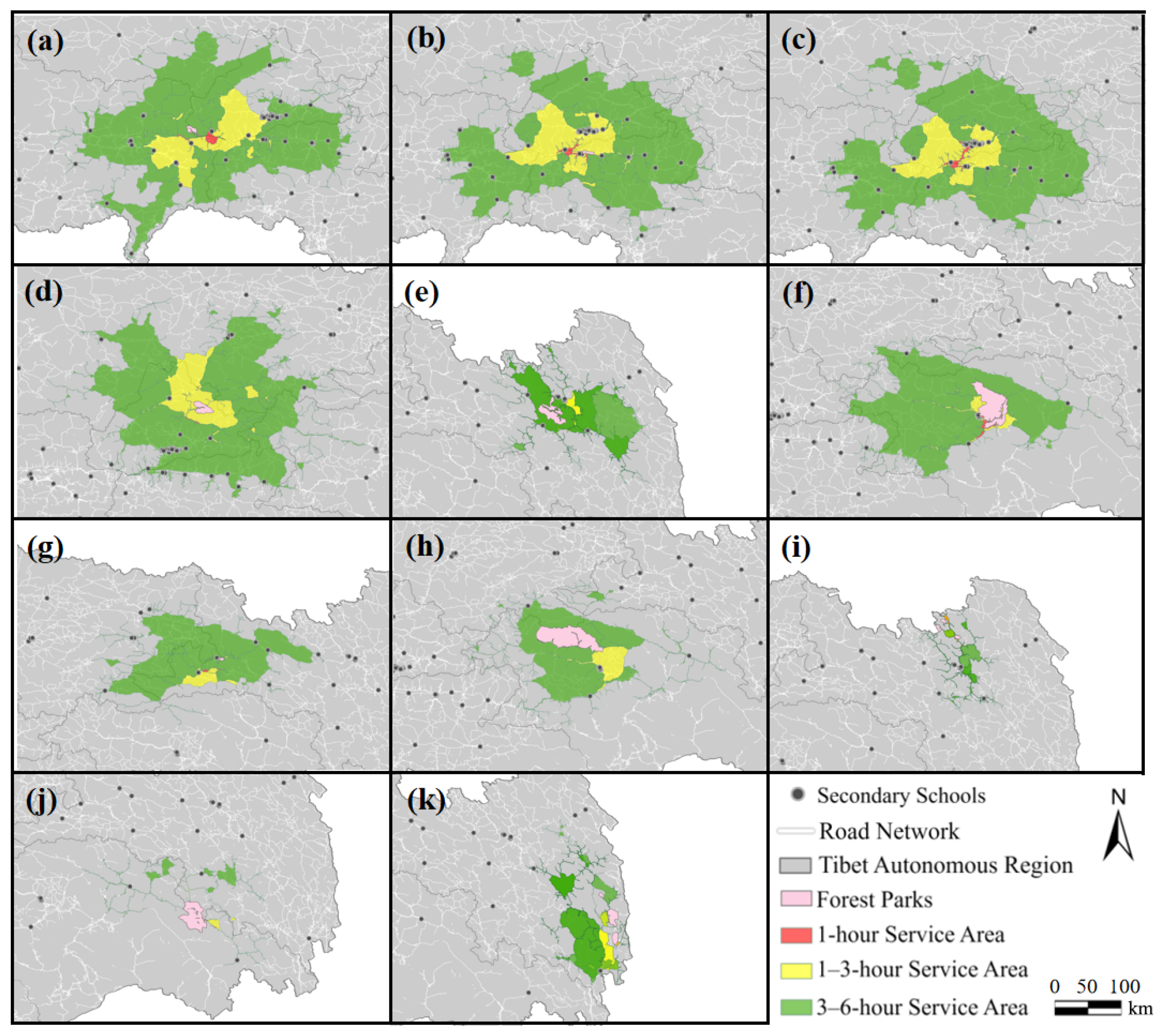
The spatial service areas of the 11 national forest parks in Tibet were first analyzed based on travel-time thresholds of 1 h, 3 h, and 6 h (Figure 4). Clear spatial heterogeneity is observed among different forest parks in terms of their accessibility to secondary schools.
Forest parks located in central Tibet, particularly around Lhasa, such as Caina and Jiedexiu, exhibit relatively extensive service coverage and can reach a large number of secondary schools within short travel times. In contrast, forest parks in eastern and border regions, including Ranwu and Mangkam, show significantly more limited accessibility, with most surrounding schools only falling within longer travel-time thresholds or remaining largely uncovered.
These differences indicate that the spatial reach of forest parks is strongly influenced by regional transportation conditions and geographical location, resulting in an uneven distribution of ecological education resources.
The statistical results further confirm the spatial disparities observed in the service areas (Table 1). Among the 11 forest parks, three parks (Nimu, Jiedexiu, and Caina) are classified as having high service capacity, with strong coverage of secondary schools within 1–6 h travel times. Three parks (Reting, Karuo Yeguola, and Sejila) fall into the medium category, showing moderate accessibility performance. The remaining five parks, including Bianba Dongxiang, Basum Co., Karuo Zhaquju, Ranwu, and Mangkam, are classified as low-service-capacity areas.
In general, forest parks with higher service capacity tend to be located in regions with relatively dense road networks and higher school concentrations, while low-capacity parks are mostly situated in more remote or topographically constrained areas.
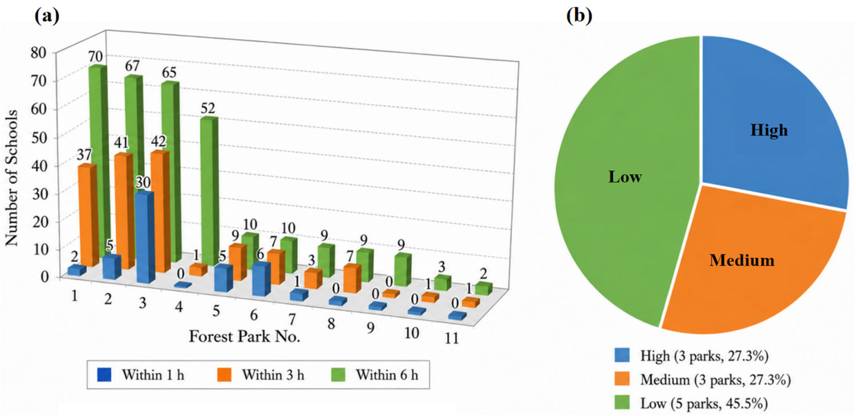
Figure 5 reveals significant heterogeneity in the educational service capacity of the 11 national forest parks in Tibet. Under the 1 h threshold, most parks cover only a very limited number of schools, indicating that short-distance accessibility is generally weak. Among all parks, Park 3 stands out by covering 30 schools within 1 h, suggesting a strong locational advantage and closer proximity to school clusters. In contrast, several parks, including Parks 4, 8, 9, 10, and 11, do not cover any schools within this threshold, reflecting substantial constraints in near-distance access.
As travel time increases, inter-park differences become more evident. At the 3 h threshold, Parks 1, 2, and 3 form the leading group, with coverage rising to 37, 41, and 42 schools, respectively. At the 6 h threshold, the same group remains dominant, reaching 70, 67, and 65 schools, respectively. Park 4 also shows a notable increase at this stage, covering 52 schools within 6 h, which suggests that although its short-range accessibility is weak, it still possesses broader regional service potential. By contrast, Parks 7–11 remain at relatively low coverage levels even under the 6 h threshold, indicating persistent spatial marginality.
The pie chart in Figure 5b further summarizes these differences by classifying the parks into three service-capacity levels. Low-capacity parks account for the largest share (45.5%), whereas high-capacity and medium-capacity parks each account for 27.3%. Overall, the results suggest that forest park educational services in Tibet are characterized by a clear polarization pattern: a few parks provide strong and extensive school coverage, while nearly half of the parks remain limited in their ability to serve surrounding schools.
The statistical results further demonstrate the strong differentiation in forest park service capacity. The mean number of schools covered by the 11 parks increases from 4.45 within 1 h to 13.55 within 3 h and 27.82 within 6 h. However, the expansion of service coverage is highly uneven among parks. Nimu, Jiedexiu, and Caina consistently maintain the largest school coverage, whereas several peripheral parks continue to serve fewer than 10 schools even under the 6 h threshold. These differences indicate that expanding the travel-time range increases overall potential connectivity but does not eliminate the structural imbalance in educational service provision among forest parks.
The accessibility results can also be summarized from the perspective of potential park–school connectivity. Across the three travel-time thresholds, the total number of accessible park–school links increases from 49 within 1 h to 149 within 3 h and 306 within 6 h. This expansion indicates that increasing the allowable travel-time budget substantially enlarges the number of potential connections between forest parks and secondary schools. However, these connections represent spatial accessibility relationships rather than observed ecosystem service flows. Actual educational use would additionally depend on field-trip frequency, student participation, school resources, and institutional capacity.
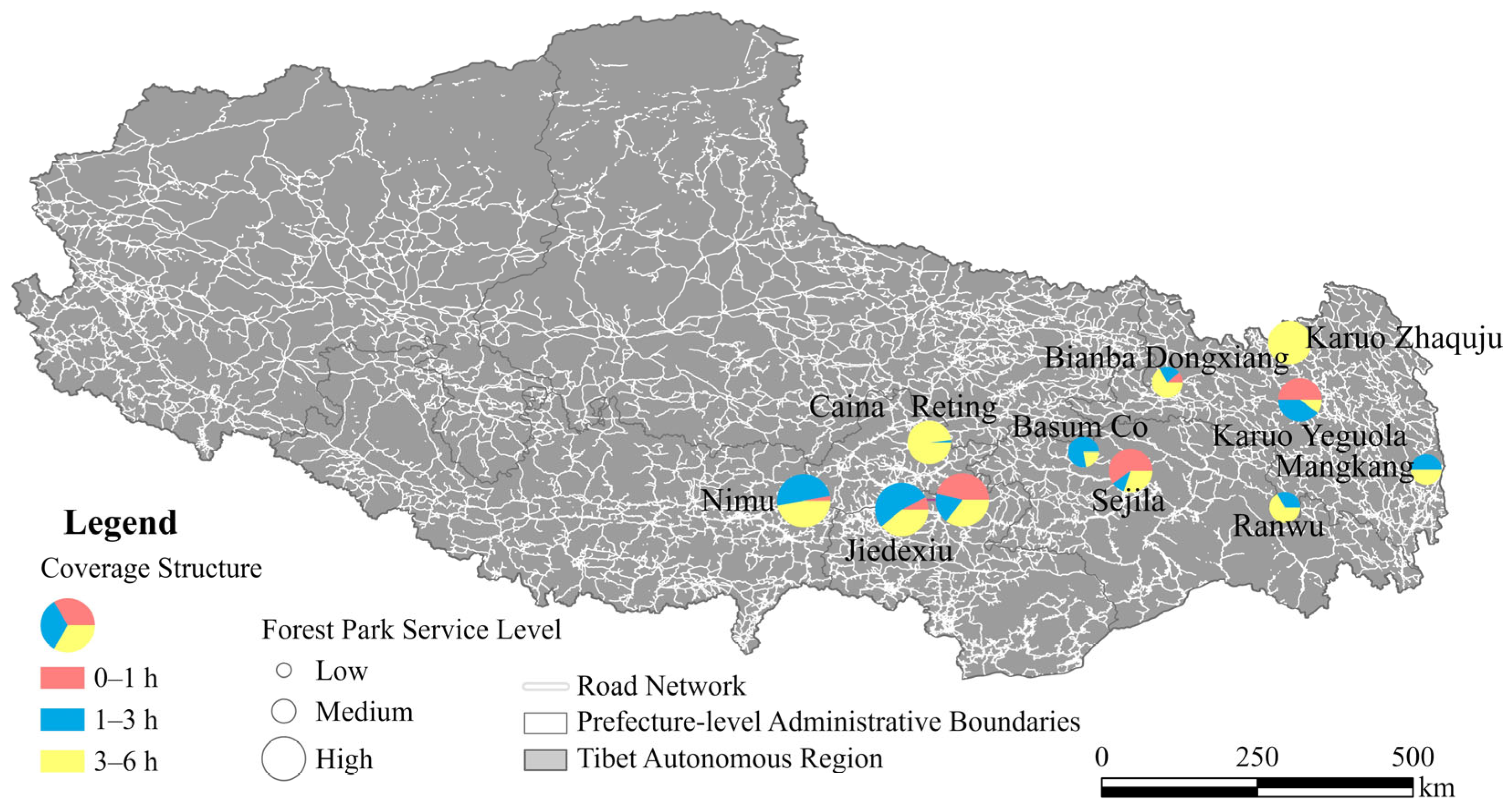
The spatial distribution of forest park service capacity shows a clear clustered pattern in Tibet, while the internal composition of accessibility is further revealed through travel-time-based pie charts (Figure 6). High-capacity forest parks are primarily concentrated in central and southeastern Tibet, especially in the Lhasa and Shannan regions, where transportation accessibility is relatively favorable and secondary schools are densely distributed.
Medium-capacity parks are mainly distributed in transitional zones surrounding the central plateau, reflecting moderate accessibility conditions shaped by both terrain constraints and road network connectivity. In contrast, low-capacity parks are located in more peripheral areas such as eastern and northern Tibet, where sparse road networks, greater terrain complexity, and lower population density jointly restrict accessibility between ecological resources and educational demand points.
Beyond the spatial clustering pattern, the pie charts further illustrate the composition of school accessibility within different travel-time thresholds (0–1 h, 1–3 h, and 3–6 h). High-capacity parks generally show a larger proportion of short- and medium-distance accessibility, indicating stronger proximity advantages and more efficient linkage with surrounding school clusters. By contrast, low-capacity parks tend to rely more heavily on long-distance accessibility (3–6 h), reflecting weaker spatial coupling between ecological resources and educational demand.
Overall, the results demonstrate a strong spatial mismatch between forest parks and secondary school distribution while also highlighting substantial differences in the internal accessibility structure across parks. This suggests that forest park service capacity in Tibet is jointly shaped by spatial location, transportation connectivity, and multi-scale travel-time constraints.

3.3. Accessibility Pattern of Secondary Schools

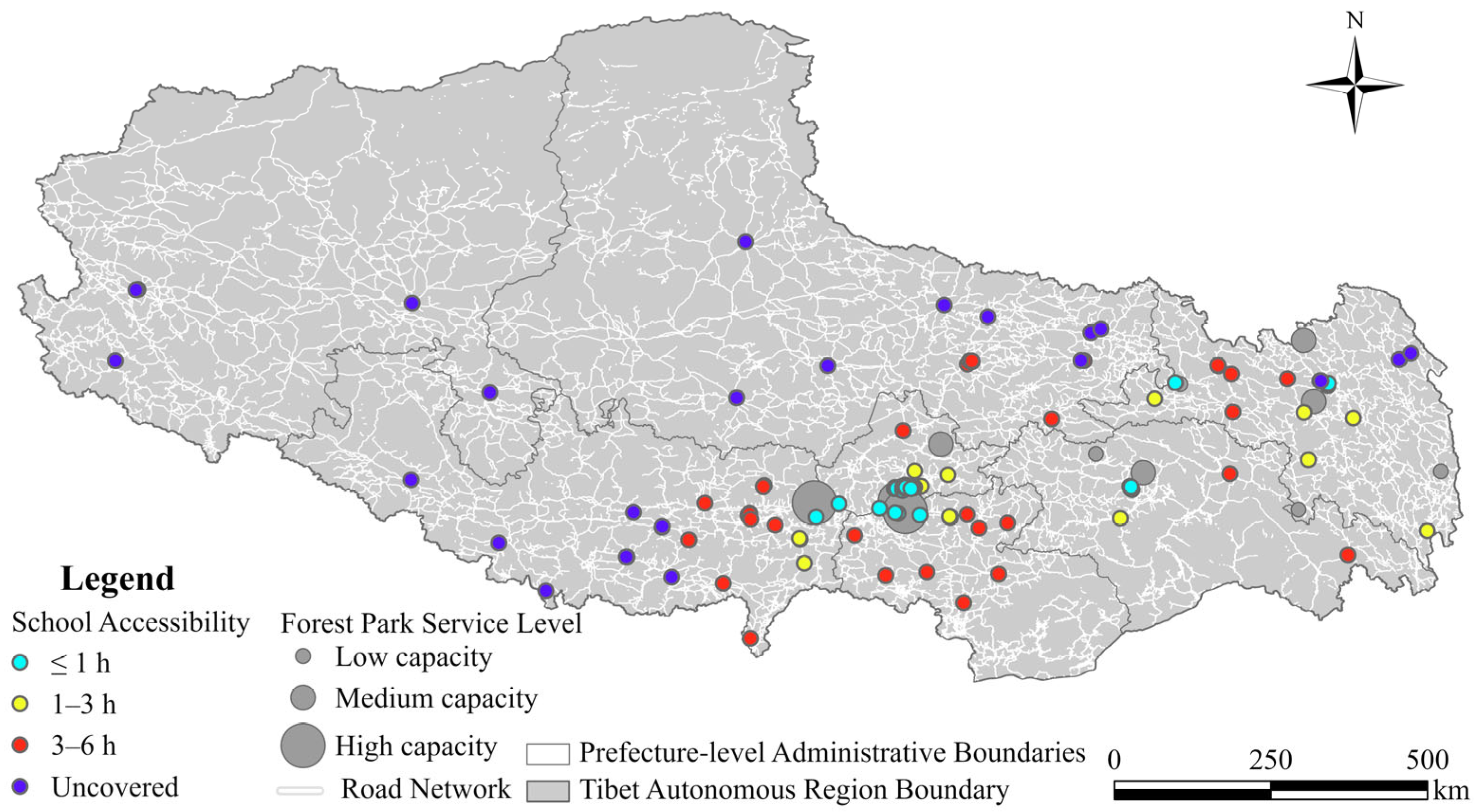
The accessibility levels of secondary schools to forest parks show a clear spatially uneven pattern across Tibet (Figure 7). Schools with high accessibility (≤1 h) are mainly concentrated in central Tibet, particularly around Lhasa and nearby areas where road connectivity is relatively strong, and forest parks are located close to school clusters. These schools have the most favorable conditions for frequent field-based geography learning.
Medium-accessibility schools (1–3 h) are distributed around the high-accessibility core and in some eastern and southeastern areas with relatively good transport connections. These schools can access forest parks within a feasible one-day travel range, indicating moderate opportunities for field-based ecological learning.
Low-accessibility schools (3–6 h) are more widely distributed across central, eastern, and southern Tibet. Although these schools remain within the maximum service threshold, the longer travel time limits the frequency and flexibility of outdoor learning activities. In contrast, uncovered schools are mainly located in western and northern Tibet, where road networks are sparse, and forest parks are distant from school locations.
Overall, the spatial pattern indicates a distinct core–periphery structure. Schools around Lhasa and several eastern transport corridors have better access to forest park resources, whereas schools in remote western and northern areas face stronger spatial barriers. This suggests that the opportunity for secondary schools to use forest parks as ecological learning sites is highly dependent on both road accessibility and the spatial matching between schools and forest parks.

3.4. Accessibility-Informed Educational Implications and Field Education Design

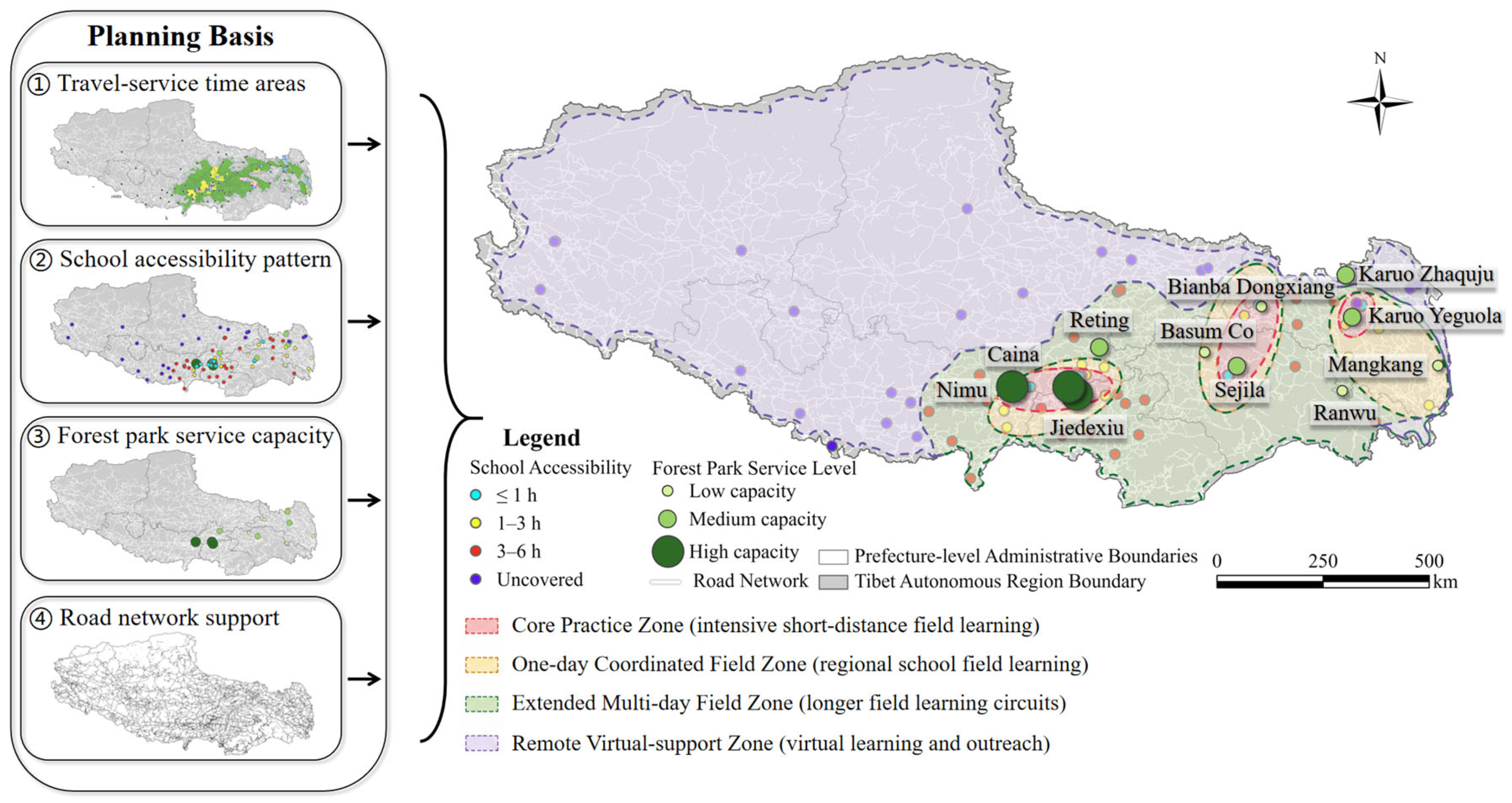
Based on the accessibility classification results, this study constructs a differentiated field education design framework that links travel-time constraints, spatial accessibility patterns, and feasible geography field teaching strategies (Figure 8). The classification of accessibility into four levels—high, medium, low, and uncovered—provides the structural basis for translating spatial analysis results into educational planning (Table 2).
The planning framework (Figure 8) illustrates how travel-service time areas, school accessibility patterns, forest park service capacity, and road network support jointly shape the feasibility of field-based education. Together, these components form an integrated system in which spatial accessibility is not only an analytical output but also a direct input for educational design.
To translate accessibility results into educational implications, the framework uses three linked implementation layers. First, teaching organization connects spatial opportunity to inquiry, project-based investigation, repeated observation, and hybrid field–virtual learning. Second, curriculum integration organizes field learning as a sequence of pre-field preparation, on-site data collection, and post-field interpretation, allowing field evidence to enter regular geography units rather than remain an isolated excursion. Third, assessment and organizational support use field notebooks, portfolios, GIS maps, group reports, and reflective tasks, while matching each accessibility class with specific arrangements for transport coordination, park–school scheduling, teacher preparation, safety management, and cost sharing. The resulting strategies are therefore accessibility-informed educational options, not automatic prescriptions derived from travel time alone.
For schools located in the high-accessibility zone (≤1 h), the main educational implication is to prioritize curriculum-embedded and recurrent field learning. Short ecological observations can be organized as repeated modules linked to regular geography units: students formulate questions before departure, collect landscape or ecological observations on site, and complete post-field mapping, comparison, or reflection tasks. Repeated visits also make longitudinal observation possible. Assessment can combine field notebooks, observation records, GIS products, and short inquiry reports rather than relying only on classroom knowledge tests.
For schools within the medium-accessibility zone (1–3 h), implementation requires a planned integrated field module rather than assuming that every destination is automatically feasible as a routine one-day trip. Destinations near the lower end of the band may support full-day investigation, whereas trips near the upper end may require extended-day or overnight arrangements. Practical implementation should include advance park–school scheduling, shared or coordinated transport, explicit safety and contingency plans, structured group tasks, and a pre-field/field/post-field curriculum sequence. Where several schools are clustered, joint transport procurement and shared teacher preparation can reduce per-school organizational burden.
For the low-accessibility zone (3–6 h), simply recommending more thematic trips would not resolve the underlying cost and safety constraints. A more feasible pathway is a regional field-learning hub or inter-school consortium model: schools can pool transport and accommodation costs, coordinate trained staff and safety procedures, and organize fewer but longer multi-day programs around selected high-capacity parks. Virtual orientation before departure and GIS- or remote sensing-based follow-up after return can extend learning time while limiting the number of physically demanding journeys. Such programs should be conditional on budget, weather, road status, and risk assessment rather than triggered by accessibility class alone.
For uncovered schools (>6 h or not covered), the educational implication is to move beyond reliance on virtual fieldwork alone and adopt a layered local-hybrid model. Schools can combine campus and community ecological micro-sites, nearby river or grassland observations, remote interpretation sessions with park staff, GIS and remote sensing analysis, and virtual visits to representative forest-park sites. Common inquiry questions and assessment rubrics can link local observations with remote park cases, allowing students to participate in comparable curriculum goals despite unequal physical access.

4. Discussion

4.1. Spatial Inequality and Its Geographical Drivers

The uneven accessibility of forest-park-based learning resources should be understood as an issue of educational equity rather than solely as a transportation outcome. Even where ecological civilization education is intended to provide broad educational benefits, differences in spatial access may create unequal opportunities for students to participate in field-based geography and ecological learning [24]. Accessibility therefore represents an important geographical condition affecting whether ecological education can extend beyond classroom instruction.
This inequality reflects the combined influence of administrative centrality, educational resource concentration, settlement patterns, transportation investment, and topographic constraints. Regional centers concentrate schools, public services, and transport infrastructure, strengthening the spatial correspondence between educational demand and accessible ecological resources. At the same time, mountainous terrain channels roads and settlements through valleys, basins, and intermontane corridors, producing uneven and corridor-oriented accessibility rather than uniform spatial coverage [25]. The observed pattern is therefore the result of long-term interactions between geographical conditions and institutional development.
From a policy perspective, spatial inequality cannot be addressed through a uniform regional model. Improvements in road connectivity may enhance access in some locations, but infrastructure expansion alone cannot fully resolve differences arising from terrain, settlement dispersion, school resources, and institutional capacity. Regional education planning should therefore combine spatial accessibility assessment with coordinated resource allocation, park–school cooperation, and support for geographically disadvantaged schools [36]. Spatial accessibility should be regarded as one component of educational equity rather than as its complete representation.

4.2. Interpreting Educational Accessibility Through Ecosystem Service Flows

The ecosystem service flow perspective provides a relational interpretation of educational accessibility. Forest parks represent the supply of ecological and cultural learning resources, secondary schools represent educational demand, and road networks provide the spatial pathways through which potential educational benefits may be accessed [26]. From this perspective, the educational value of a forest park depends not only on the presence of natural resources but also on the spatial connections that enable students and teachers to reach and use them.
This interpretation explains why ecological resource abundance does not automatically produce educational opportunity. A forest park with rich landscapes and substantial environmental education potential may remain weakly connected to schools because of distance, terrain, or limited transportation infrastructure. Conversely, parks located near transportation corridors and school clusters may potentially serve a larger educational population [28,29]. The supply–pathway–demand framework therefore extends conventional resource inventories by identifying the spatial relationships through which ecological learning opportunities may be formed.
The framework should nevertheless be interpreted as an assessment of potential rather than realized ecosystem service flows. A short modeled travel time indicates that educational use is spatially possible, but it does not demonstrate that a visit occurred, how many students participated, or whether educational outcomes were achieved. Following the distinction among ecosystem service supply, flow, and actual use [37], a more comprehensive evaluation would require field-trip records, participant numbers, seasonal travel information, school-level institutional capacity, and learning assessments. The current analysis therefore identifies the spatial conditions under which ecological learning resources may become available to schools rather than measuring their actual educational use.

4.3. Transferability and Implementation Conditions

The educational design presented in Section 3.4 demonstrates how spatial accessibility results can be translated into differentiated planning options. Its broader value lies in connecting geographical analysis with curriculum organization, rather than prescribing a fixed teaching format for each travel-time category. Field-based learning is most effective when direct observation is linked to clearly defined inquiry questions, curriculum content, and post-field interpretation [33]. Accessibility classification can support this process by helping schools identify feasible forms and frequencies of field engagement.
However, the implementation of accessibility-informed educational design depends on institutional and organizational conditions that are not captured by travel time alone. Effective field education requires coordination among schools, forest parks, education authorities, teachers, transport providers, students, and families. Pre-field preparation, on-site investigation, and post-field analysis also need to be integrated into a coherent learning sequence rather than treated as separate activities [34]. Financial resources, teacher preparation, safety management, weather conditions, administrative approval, and curriculum schedules may all influence whether a spatially feasible activity can be implemented.
The framework is potentially transferable to other mountainous, plateau, island, border, or infrastructure-constrained regions, but its parameters should not be applied mechanically. Travel-time thresholds, road-speed assumptions, ecological learning destinations, school distribution, institutional capacity, and available teaching technologies should be recalibrated according to local conditions. Virtual fieldwork, GIS, remote sensing, local ecological sites, and remote interaction with park staff can complement direct field experience where physical access is constrained [38]. These approaches should support comparable curriculum goals while remaining responsive to local environmental and educational contexts.

4.4. Limitations and Future Research

This study evaluates potential accessibility using OSM road data and fixed road-class-specific travel speeds. These assumptions may not fully capture differences in road quality, maintenance, traffic regulation, vehicle conditions, seasonal hazards, or temporary closures. Snow, rainfall, landslides, and freeze–thaw damage may cause actual travel times to differ from the modeled estimates.
Forest parks are represented by road-network access points, while internal roads, trails, elevation differences, restricted management zones, and the locations of specific ecological teaching sites are not incorporated. The analysis also treats each school as an equivalent demand node and does not account for enrollment, financial resources, teacher capacity, transport availability, institutional support, or willingness to organize field activities.
Future research should combine network analysis with observed travel times, seasonal transportation conditions, internal park accessibility, school and teacher surveys, field-trip records, organizational costs, and educational outcomes. Such evidence would help distinguish potential spatial opportunity from actual participation and clarify how accessibility is converted into realized educational use.

5. Conclusions

This study evaluated the potential accessibility between 11 forest parks and 137 secondary schools in Tibet using a network-based travel-time approach. The results reveal a pronounced core–periphery pattern. Forest parks located around Lhasa and major transport corridors have substantially greater potential to serve secondary schools, whereas many schools in western and northern Tibet remain beyond the 6 h service range. Expanding the travel-time threshold increases the overall number of potential park–school connections but does not eliminate the spatial concentration of educational service capacity.
By integrating the ecosystem service flow perspective with geography field education, this study interprets accessibility as the spatial condition through which ecological learning resources may become available to schools. The park-side and school-side assessments jointly identify mismatches between ecological resource supply, transportation pathways, and educational demand. The resulting accessibility classes can support differentiated educational planning, including recurrent curriculum-embedded inquiry in highly accessible areas, coordinated field modules and inter-school cooperation in less accessible areas, and local or hybrid alternatives where direct forest-park access is strongly constrained.
The results represent potential spatial accessibility rather than actual educational participation. The model does not incorporate seasonal road conditions, internal park travel, school resources, organizational costs, field-trip frequency, or learning outcomes. Future research should combine network analysis with observed travel times, school and teacher surveys, institutional information, and actual field-education records to examine how potential accessibility is converted into realized educational use.

Author Contributions

Methodology, J.M.; formal analysis, Z.W. and J.M.; investigation, Z.W.; data curation, Z.W.; writing—original draft, J.M.; writing—review and editing, Z.W. and S.L.; visualization, J.M.; project administration, S.L.; funding acquisition, S.L. All authors have read and agreed to the published version of the manuscript.

Funding

This research was funded by the National Natural Science Foundation of China (grant number 42271097) and the National Key Research and Development Program of China (grant number 2022YFF1303204).

Data Availability Statement

The raw data supporting the conclusions of this article will be made available by the authors on request.

Conflicts of Interest

The authors declare no conflicts of interest.

References

  1. Zhang, D.; Peng, J.; Yang, Z. Identifying Urban Agglomeration’s Range: Integrating Clustering and Accessibility Analysis. Cities 2026, 171, 106708. [Google Scholar] [CrossRef]
  2. Toor, G.; Tater, N.G.; Chandra, T. Exploring Recent Trends in Integrating Urban Planning and Ecology. Environ. Dev. Sustain. 2024, 26, 19093–19111. [Google Scholar] [CrossRef]
  3. Li, Y.; Tang, Y.-T.; Tan-Mullins, M.; Ives, C.D. Exploring the Potential Opportunities of China’s Environmental Agenda, Ecological Civilization, on Global Sustainable Development. Sustainability 2023, 15, 5135. [Google Scholar] [CrossRef]
  4. Wu, M.; Liu, C.-C. What Could and Should Ecological Civilization Education Be? Sustainability 2021, 13, 11735. [Google Scholar] [CrossRef]
  5. Perkins, N.; Hazelton, E.; Erickson, J.; Allan, W. Place-Based Education and Geographic Information Systems: Enhancing the Spatial Awareness of Middle School Students in Maine. J. Geogr. 2010, 109, 213–218. [Google Scholar] [CrossRef]
  6. Mann, J.; Gray, T.; Truong, S.; Brymer, E.; Passy, R.; Ho, S.; Sahlberg, P.; Ward, K.; Bentsen, P.; Curry, C.; et al. Getting Out of the Classroom and Into Nature: A Systematic Review of Nature-Specific Outdoor Learning on School Children’s Learning and Development. Front. Public Health 2022, 10, 877058. [Google Scholar] [CrossRef] [PubMed]
  7. Becker, C.; Lauterbach, G.; Spengler, S.; Dettweiler, U.; Mess, F. Effects of Regular Classes in Outdoor Education Settings: A Systematic Review on Students’ Learning, Social and Health Dimensions. Int. J. Environ. Res. Public Health 2017, 14, 485. [Google Scholar] [CrossRef] [PubMed]
  8. Millward, A.A.; Borisenoka, I.; Bhagat, N.; LeBreton, G.T.O. Environmental Education during the COVID-19 Pandemic: Lessons from Ontario, Canada. Front. Educ. 2024, 9, 1430882. [Google Scholar] [CrossRef]
  9. Wu, N.; Liang, Z.; Liu, M.; Zhang, J.; Guo, Y.; Qiao, J. Regional drivers or local constraints? Spatial patterns and development pathways of specialized villages in Henan, China. J. Rural Stud. 2026, 121, 103877. [Google Scholar] [CrossRef]
  10. Wang, Z.; Jian, Y.; Huang, Z.; Qureshi, S.; Cheng, K.; Bai, Z.; Zhang, Q. Transforming Research on Recreational Ecosystem Services into Applications and Governance. Land 2023, 12, 509. [Google Scholar] [CrossRef]
  11. Mao, J.; Wang, Z.; Ding, Z. Evaluating and Identifying Influencing Factors of the Development Level of Regional Red Tourism Scenic Spots: A Case Study of the Central Plains Region. Reg. Ecol. Manag. 2026, 1, 5. [Google Scholar] [CrossRef]
  12. Ma, X.; Cui, F. Perceived Accessibility: Literature Review and Future Prospects. J. Transp. Land Use 2024, 17, 827–847. [Google Scholar] [CrossRef]
  13. Luo, W.; Chen, H.; Yang, Z.; Liu, J. Accessibility and Equity of Park Green Spaces: Considering Differences in Walking Speeds Across Age Groups. Land 2024, 13, 2240. [Google Scholar] [CrossRef]
  14. Wang, Z.; Liu, S.; Liu, M.; Wang, W.; Li, Y.; Fan, J.; Lin, J.; Tian, Z.; Mao, J.; Wu, G. Coupling Relationships between Water-Carbon Ecosystem Service Flows under the Integrated Perspective of “Three Waters”: A Case Study in Guizhou Province. Ecol. Front. 2025, 45, 1774–1783. [Google Scholar] [CrossRef]
  15. Fan, Q.; Lu, Q.; Yang, X. Spatiotemporal Assessment of Recreation Ecosystem Service Flow from Green Spaces in Zhengzhou’s Main Urban Area. Humanit. Soc. Sci. Commun. 2025, 12, 97. [Google Scholar] [CrossRef]
  16. Sun, X.; Liu, H.; Liao, C.; Nong, H.; Yang, P. Understanding Recreational Ecosystem Service Supply-Demand Mismatch and Social Groups’ Preferences: Implications for Urban–Rural Planning. Landsc. Urban Plan. 2024, 241, 104903. [Google Scholar] [CrossRef]
  17. Morse, W.C.; Cerveny, L.K.; Blahna, D.J. Coordinating and Standardizing Outdoor Recreation Supply and Demand Databases to Facilitate Management and Promote Conservation, Health, and Accessibility. J. Park Recreat. Adm. 2022, 40, 175–194. [Google Scholar] [CrossRef]
  18. Wang, Z.; Shi, Z.; Zhu, W.; Mao, J.; Liu, S. Policy Orientations Reshape Landscape Connectivity in Mountainous Regions: Simulation and Spatial Optimization in Funiu Mountain Area in Central China. Glob. Ecol. Conserv. 2026, 66, e04105. [Google Scholar] [CrossRef]
  19. Zhou, C.; Zhang, D.; He, X. Transportation Accessibility Evaluation of Educational Institutions Conducting Field Environmental Education Activities in Ecological Protection Areas: A Case Study of Zhuhai City. Sustainability 2021, 13, 9392. [Google Scholar] [CrossRef]
  20. Mao, J.; Liu, Y.; Wang, C.; Wu, H.; Sha, L.; Wang, Z. Mapping ecological civilization education from a geographical education perspective: Knowledge structure, thematic evolution, and pedagogical implications. J. Eur. Acad. Open Univ. 2026, 2. [Google Scholar] [CrossRef]
  21. Lu, T.; Li, C.; Zhou, W.; Liu, Y. Fuzzy Assessment of Ecological Security on the Qinghai–Tibet Plateau Based on Pressure–State–Response Framework. Remote Sens. 2023, 15, 1293. [Google Scholar] [CrossRef]
  22. Liu, L.; Zhang, S.; Liu, W.; Qu, H.; Guo, L. Spatiotemporal Changes and Simulation Prediction of Ecological Security Pattern on the Qinghai–Tibet Plateau Based on Deep Learning. Land 2024, 13, 1073. [Google Scholar] [CrossRef]
  23. Gao, X.; Sun, D. Transport Accessibility and Social Demand: A Case Study of the Tibetan Plateau. PLoS ONE 2021, 16, e0257028. [Google Scholar] [CrossRef] [PubMed]
  24. Wu, S.; Liu, K.; Zhang, W.; Dou, Y.; Chen, Y.; Zhang, T.; Li, D. An Integrated Analysis Framework of Supply, Demand, Flow, and Use to Better Understand Realized Ecosystem Services. Ecosyst. Serv. 2024, 69, 101649. [Google Scholar] [CrossRef]
  25. Burkhard, B.; Kandziora, M.; Hou, Y.; Müller, F. Ecosystem Service Potentials, Flows and Demands—Concepts for Spatial Localisation, Indication and Quantification. Landsc. Online 2014, 34, 1–32. [Google Scholar] [CrossRef]
  26. Higgins, C.; Palm, M.; DeJohn, A.; Xi, L.; Vaughan, J.; Farber, S.; Widener, M.; Miller, E. Calculating Place-Based Transit Accessibility: Methods, Tools and Algorithmic Dependence. J. Transp. Land Use 2022, 15, 95–116. [Google Scholar] [CrossRef]
  27. Delamater, P.L.; Messina, J.P.; Shortridge, A.M.; Grady, S.C. Measuring Geographic Access to Health Care: Raster and Network-Based Methods. Int. J. Health Geogr. 2012, 11, 15. [Google Scholar] [CrossRef] [PubMed]
  28. Florath, J.; Chanussot, J.; Keller, S. Road Accessibility during Natural Hazards Based on Volunteered Geographic Information Data and Network Analysis. ISPRS Int. J. Geo-Inf. 2024, 13, 107. [Google Scholar] [CrossRef]
  29. Liu, Y.; Gu, H.; Shi, Y. Spatial Accessibility Analysis of Medical Facilities Based on Public Transportation Networks. Int. J. Environ. Res. Public Health 2022, 19, 16224. [Google Scholar] [CrossRef] [PubMed]
  30. Wang, Z.; Shen, X.; Mao, J.; Yao, Z.; Liu, S. Spatiotemporal evolution and driving factors of land economic density at township scale: A case study of Anyang City, China. Land 2025, 14, 2227. [Google Scholar] [CrossRef]
  31. Kelobonye, K.; Zhou, H.; McCarney, G.; Xia, J. Measuring the Accessibility and Spatial Equity of Urban Services under Competition Using the Cumulative Opportunities Measure. J. Transp. Geogr. 2020, 85, 102706. [Google Scholar] [CrossRef]
  32. Yang, Y.; He, R.; Tian, G.; Shi, Z.; Wang, X.; Fekete, A. Equity Study on Urban Park Accessibility Based on Improved 2SFCA Method in Zhengzhou, China. Land 2022, 11, 2045. [Google Scholar] [CrossRef]
  33. Meena, D.K.; Tripathi, R.; Agrawal, S. An Evaluation of Primary Schools and Its Accessibility Using GIS Techniques: A Case Study of Prayagraj District, India. GeoJournal 2023, 88, 1921–1951. [Google Scholar] [CrossRef] [PubMed]
  34. Jiang, J.; Wang, Z.; Yong, Z.; He, J.; Yang, Y.; Zhang, Y. Spatial Distribution and Accessibility Analysis of Primary School Facilities in Mega Cities: A Case Study of Chengdu. Sustainability 2024, 16, 723. [Google Scholar] [CrossRef]
  35. Sakti, A.D.; Rahadianto, M.A.E.; Pradhan, B.; Muhammad, H.N.; Andani, I.G.A.; Sarli, P.W.; Abdillah, M.R.; Anggraini, T.S.; Purnomo, A.D.; Ridwana, R.; et al. School Location Analysis by Integrating the Accessibility, Natural and Biological Hazards to Support Equal Access to Education. ISPRS Int. J. Geo-Inf. 2021, 11, 12. [Google Scholar] [CrossRef]
  36. Ellington, A.; Prado, C. Connecting Schools and Communities: A Look at Place-Based Learning and Equitable Access in SF Bay Area Outdoor Environmental Education. Environ. Educ. Res. 2024, 30, 1327–1347. [Google Scholar] [CrossRef]
  37. Villamagna, A.M.; Angermeier, P.L.; Bennett, E.M. Capacity, Pressure, Demand, and Flow: A Conceptual Framework for Analyzing Ecosystem Service Provision and Delivery. Ecol. Complex. 2013, 15, 114–121. [Google Scholar] [CrossRef]
  38. Mead, C.; Buxner, S.; Bruce, G.; Taylor, W.; Semken, S.; Anbar, A.D. Immersive, Interactive Virtual Field Trips Promote Science Learning. J. Geosci. Educ. 2019, 67, 131–142. [Google Scholar] [CrossRef]
Figure 1. Study area and spatial context of the Tibet Autonomous Region, China. Subfigure (a) shows the location of Tibet within China; (b) presents the digital elevation model (DEM) of Tibet; and (c) illustrates the road network and distribution of national forest parks in the study area.
Land 15 01389 g001
Figure 2. Research framework of this study.
Land 15 01389 g002
Figure 3. Travel-time service areas of forest parks for secondary-school geography field education in Tibet.
Land 15 01389 g003
Figure 4. Spatial service areas of 11 national forest parks in Tibet based on travel-time accessibility (1 h, 3 h, and 6 h thresholds). Subfigures (ak) correspond to the service areas of the 11 national forest parks in Tibet: (a) Nimu Forest Park, (b) Jiedexiu Forest Park, (c) Caina Forest Park, (d) Reting Forest Park, (e) Karuo Yeguola Forest Park, (f) Sejila Forest Park, (g) Bianba Dongxiang Forest Park, (h) Basum Co Forest Park, (i) Karuo Zhaquju Forest Park, (j) Ranwu Forest Park, and (k) Mangkam Forest Park.
Land 15 01389 g004
Figure 5. Comparison of school coverage and service capacity levels of 11 national forest parks in Tibet: (a) Number of secondary schools covered within 1 h, 3 h, and 6 h by each forest park. (b) Proportion of forest parks by service capacity level. Percentages may not sum to 100% because of rounding.
Land 15 01389 g005
Figure 6. Spatial distribution and travel-time composition of forest park educational service capacity in Tibet.
Land 15 01389 g006
Figure 7. Classification of secondary school accessibility and corresponding educational implications in Tibet.
Land 15 01389 g007
Figure 8. Accessibility-based planning framework for differentiated geography field education in Tibet.
Land 15 01389 g008
Table 1. Accessibility-based service capacity classification of forest parks in Tibet.
No.Forest ParkSchools Within 1 hSchools Within 3 hSchools Within 6 hService Capacity Level
1Tibet Nimu National Forest Nature Park23770High
2Tibet Jiedexiu National Forest Nature Park54167High
3Tibet Caina Autonomous Region-Level Forest Nature Park304265High
4Tibet Reting National Forest Nature Park0152Medium
5Tibet Karuo Yeguola Autonomous Region-Level Forest Nature Park5910Medium
6Tibet Sejila National Forest Nature Park6710Medium
7Tibet Bianba Dongxiang Autonomous Region-Level Forest Nature Park139Low
8Tibet Basum Co National Forest Nature Park079Low
9Tibet Karuo Zhaquju Autonomous Region-Level Forest Nature Park009Low
10Tibet Ranwu National Forest Nature Park013Low
11Tibet Mangkang Autonomous Region-Level Forest Nature Park012Low
Table 2. Interpretation of school accessibility levels and educational implications.
Accessibility LevelTravel TimeEducational MeaningSuggested Teaching Strategy
High≤1 hRoutine or half-day use potentially feasibleCurriculum-embedded inquiry; repeated observation; portfolio assessment
Medium1–3 hFull-day to extended-day/overnight planning, depending on exact time and logisticsIntegrated field module; coordinated transport; park–school scheduling and risk planning
Low3–6 hMulti-day or regional-hub field learningInter-school consortium; pooled costs; fewer, longer thematic programs; hybrid preparation and follow-up
Uncovered>6 h/not coveredDirect forest-park access highly constrainedLocal ecological micro-sites; virtual fieldwork; GIS/remote sensing; remote park interpretation
Disclaimer/Publisher’s Note: The statements, opinions and data contained in all publications are solely those of the individual author(s) and contributor(s) and not of MDPI and/or the editor(s). MDPI and/or the editor(s) disclaim responsibility for any injury to people or property resulting from any ideas, methods, instructions or products referred to in the content.