


Abstract
Understanding the driving mechanisms of land-use structure change is fundamental for exploring co-evolutionary dynamics of coupled human-land systems. This study focuses on traditional villages in Enshi Tujia and Miao Autonomous Prefecture, integrating spatial analysis, landscape pattern indices, and structural equation modeling (SEM) with field surveys and multi-source data. It analyzes spatial distribution, spatiotemporal evolution, and the direct and indirect pathways of topographic heterogeneity, human activities, economic development, and social level on land-use structure change. Results show: (1) Villages concentrate in mountainous junctions at 800–1200 m (52.2%), forming a multi-core, west-dense east-sparse pattern with significant spatial dependence. (2) During 1990–2020, Dong villages exhibited a development-oriented evolution, with slightly expanded cultivated and forest land, intensified fragmentation (patch density increased by up to 8.55%), increased landscape diversity, and slightly decreased grassland and water, reflecting an adaptive balance between economic development and ecological constraints. (3) SEM reveals that topographic heterogeneity exerts significant negative direct effects on human activities (−0.694) and economic development (−0.686), and indirectly constrains social level through multiple mediating pathways; human activities (0.829) and economic development (0.837) strongly drive social level, with economic development also synergistically promoting human activities. This study reveals cascading transmission mechanisms of land-use structure change, providing an empirically grounded theoretical foundation and decision-making reference for ecological protection, cultural inheritance, and sustainable development in mountainous ethnic areas.
1. Introduction
Throughout human social development, various production and living activities depend on land resources. Changes in land-use processes often alter regional climate and soil ecology, which in turn affect human production and lifestyles. As a critical component of a changing environment, land use/land cover change (LUCC) has profound impacts on global ecosystems and climate [1]. Driven by vigorous promotion of economic development and global modernization, human beings have rapidly intensified the exploitation of land resources, leading to significant transformations in the global land-use structure and a pronounced conflict between human demands and land availability [2]. The protection and rational development of land and ecological resources constitute an essential link in the sustainable development of human society [3]. Against this background, exploring the rational use of land resources and its impact on the regional ecological environment has become an important research issue that requires urgent attention.
Traditional villages are regarded as “nature-society” complex systems, serving as the core carriers of long-term ecological adaptation and livelihood coupling, and as key units for studying human-environment coordination [4]. Rapid urbanization has subjected them to intense human development, resulting in systematic ecological degradation and challenges such as fragmented landscapes, deteriorating ecosystems, and an imbalance between protection and development [5]. This calls for moving beyond single-element protection and reconstructing the theoretical paradigm and technical pathways for traditional village conservation from the perspective of human earth system resilience. The relevant studies in the foreign academic community mostly focus on the more inclusive research object of “settlements”, with the core centered around the protection of historical cultural heritage, spatial pattern evolution, and the coordination of human-land relations in these areas [6]. This has led to the formation of a relatively mature theoretical system and practical experience [7]. In 2021, China’s central authorities issued the Opinions on Strengthening the Protection and Inheritance of Historical and Cultural Heritage in Urban and Rural Construction, which first proposed a “system for the protection and inheritance of historical and cultural heritage in urban and rural areas,” elevating traditional village protection to territorial spatial governance [8]. This marks a paradigm shift from “single site rescue” to “comprehensive territorial control” [9]. Land, as the carrier of human activities, provides products and services and is closely linked to human survival, livelihood, production, development, society, economy, and politics [10]. Changes in land use methods transform land use structure and functions, subsequently altering spatial distribution patterns; LUCC research can promote sustainable land use. Under urbanization and economic transformation, the cultural heritage of traditional villages must be inherited, yet rapid urbanization objectively creates impacts, making these villages hotspots of acute land contradictions [11]. Therefore, quantitative LUCC research in concentrated traditional village areas supports local sustainable development and cultural protection.
The traditional villages concentrated in Enshi Prefecture, Hubei Province, offer a representative case through which to examine the challenges outlined above. This area hosts a dense distribution of nationally recognized traditional villages, whose land-use patterns embody a distinctive spatial logic [12]. The land-use structure of these villages is organized along a clear elevational gradient shaped by the region’s karst topography. Forest land dominates the steep upper slopes and ridge lines, functioning as a natural water catchment and ecological buffer. Cultivated land is concentrated on narrow valley floors and gently sloping mid-mountain terraces, where centuries of terrace construction have transformed marginal hillsides into productive paddy fields and dryland plots [13]. Yet these villages now face acute, land-use-driven problems. Accelerated fragmentation of traditional settlement patterns [14] is occurring as collectively managed forests and farmland are carved into scattered construction land under the pressure of rural tourism and infrastructure expansion. At the same time, the ecological substrate is deteriorating [15] abandonment or marginalization of traditional woodland and agroforestry management has resulted in tangible water shortages during critical farming periods, intensified soil erosion, and the progressive disappearance of managed forest patches [16]. Finally, conservation mandates and development aspirations are increasingly in tension: ecological redlines, hillside cultivation bans, and reforestation programs, while ecologically effective, have generated social frictions [17] by restricting timber harvesting, reducing subsistence cropland, and prohibiting construction within ecological zones, directly colliding with the spatial demands of tourism entrepreneurship that many rural households see as their main route out of poverty.
Research on land use change mechanisms focuses on interactions among driving factors and the identification of those with significant explanatory power. These factors are grouped into two broad categories: natural and socio-economic. The researcher adopted the perspective of spatial genes and established a framework of Korean traditional villages for analyzing the spatial genes of traditional villages. He discovered that there was a significant correlation among the spatial genes [18]. Plata-Rocha et al. differentiate proximate causes from underlying driving forces, a framework that has structured much global land-change research [19]. Natural factors include climatic elements such as temperature, precipitation, and humidity, and topographic characteristics such as elevation, slope, and aspect [20,21]. Socio-economic factors encompass per capita GDP, population density, industrial structure, policies, and regulations [22]. The natural environments and economic development levels differ across regions, driving factors vary spatially, requiring comprehensive consideration of multiple factors together with in-depth analysis of each factor’s relationship with land use change and of the interactions among factors [23]. Su et al. analyzed that Italy’s integrated community approach is significantly superior to China’s decentralized national-led model in terms of maintaining population, culture, and tourism quality [24]. The complexity of driving mechanisms has so far prevented a unified conclusion [25], yet a consensus on analytical approaches has emerged: comparing historical and current land use data, and constructing conceptual or mathematical models that integrate natural conditions and socio-economic development [26]. The researcher conducted on-site investigations of traditional villages, as well as interviews and questionnaires with urban architectural experts and village residents. They found that the traditional environment was regarded as an element conducive to ecological balance. The environmentally conscious residents of the villages are striving to solve the problem of garbage disposal in a more environmentally friendly way [27]. The 1995 IIASA project “Land Use/Land Cover Change Simulation for Europe and Northern Asia” systematically combined land resources, human activities, and socio-economic factors, emphasizing the important role of socio-economic drivers, particularly their impact on land use change in the study region [28]. Driving-force models include statistical, mathematical, and conceptual types, each with its own advantages and disadvantages [29]. For factors that are difficult to quantify, such as policies and customary practices [30], analysis often relies on expert experience and conceptual models, while mathematical models like principal component analysis, logistic regression, and multiple regression can quantitatively assess the effects of influencing factors [31]. Overall, land use encompasses population, economy, and ecological environment, and the research content can be summarized into four main areas: (1) historical processes of land use change, analyzing spatiotemporal patterns and quantitative changes from the past to the present [32]; (2) driving forces of land use change; (3) ecological effects of land use change, i.e., the impacts on the ecological environment and on human social ecology [33]; and (4) prediction of land use change trends, using various methods and models to forecast future directions [34].
These studies provide a rich background, illustrating the multidimensionality of global ecological restoration through case studies across regions and ecosystems. This study employs a resident-centered framework to examine factors shaping willingness to participate in land-use structure change, integrating perceptions of topographic constraints, social governance, government regulation, and economic development. These factors are recognized as important yet have rarely been examined together through primary survey data in mountainous traditional villages. Existing research has mostly relied on qualitative fieldwork in one or a few villages, yielding micro-level insights but limited spatial generalizability, which is insufficient for a systematic understanding of macro-regions with diverse terrains, settlement forms, and development stages. Moving beyond this paradigm, the present study takes Enshi Prefecture as the study area, covers multiple traditional villages, conducts structured questionnaire surveys at a broader spatial scale, and incorporates multi-source data such as fine-scale remote sensing imagery. This design enables macro-scale analysis of spatiotemporal land-use change patterns and identification of universal factors shaping participation willingness and their effect magnitudes, thereby integrating large-scale coverage with contextualized explanation and complementing statistical representativeness with mechanistic depth. Compared with approaches relying solely on remote sensing or macro-policy analysis, this framework is better suited to the research problem. It directly accesses micro-level behavioral mechanisms, including residents’ attitudes toward specific land-use practices, perceptions of policy legitimacy, and willingness to alter land-use behavior, which collectively produce observable land-cover outcomes. It captures mediating factors such as long-established ecological knowledge, community norms, and trust in local governance, which are invisible to satellite imagery yet decisive for policy effectiveness. It also generates field-validated primary data on the perceived effectiveness and acceptability of existing land governance approaches, providing an evidence base for designing interventions that combine ecological effectiveness with local legitimacy.
2. Materials and Methods
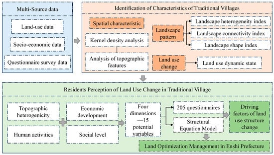
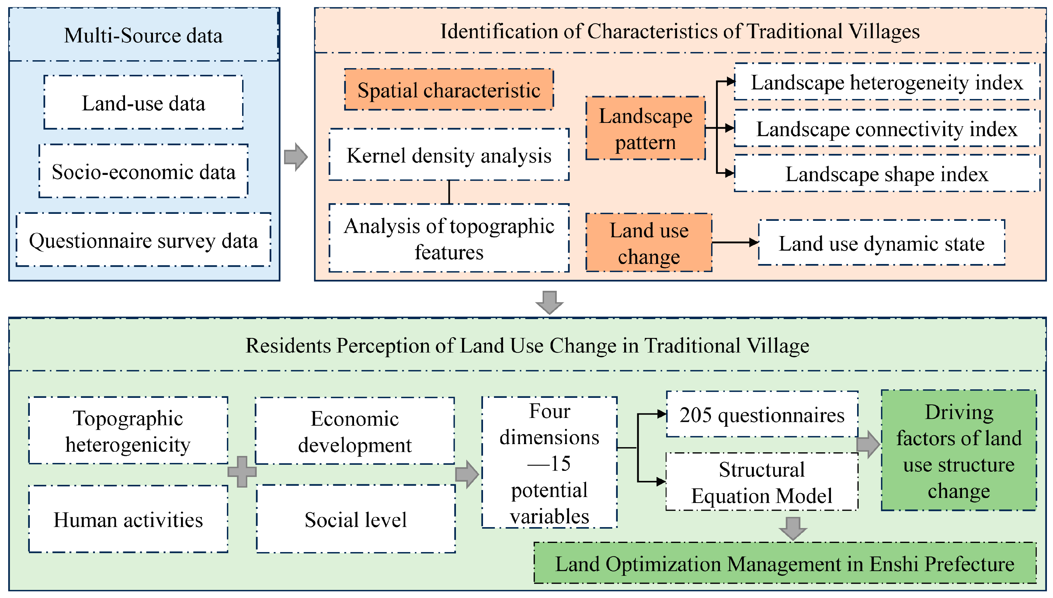
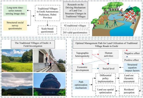
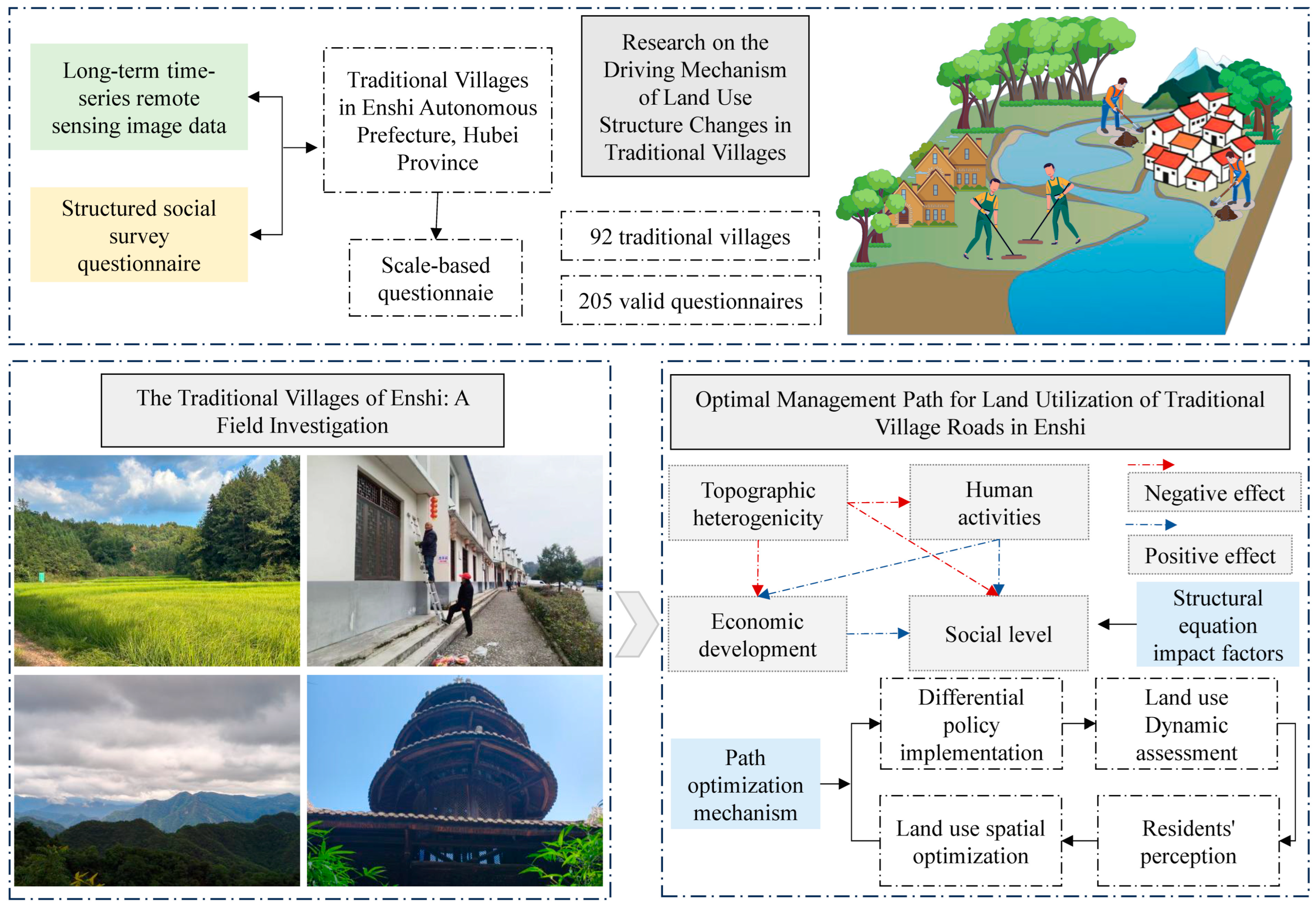
At the data level, this study integrated multi-source heterogeneous datasets, including high-resolution remote sensing imagery, a digital elevation model, land-use and land-cover data, socio-economic statistical records, and 205 resident perception questionnaires. These datasets were unified under a common spatial coordinate system and subjected to standardized preprocessing to construct a comprehensive database. At the spatial analysis level, kernel density estimation and spatial autocorrelation analysis were employed to identify the spatial distribution patterns and agglomeration characteristics of traditional villages in Enshi Prefecture. Concurrently, a land-use transition matrix and a dynamic degree model were applied to quantitatively characterize land-use change within a 2 km buffer zone surrounding each village. Landscape pattern indices were introduced to reveal the fragmentation and heterogeneity trends of land cover across the patch, class, and landscape levels. Building on these analyses, the survey data capturing residents’ perceptions of topographic constraints, economic development, social level, and human activities were incorporated into a structural equation model to systematically disentangle the multi-dimensional driving factors and their pathways influencing land-use structure change in traditional villages. Finally, by synthesizing the findings on spatial patterns, landscape evolution, and residents’ behavioral mechanisms, targeted optimization strategies were proposed to support the sustainable development of mountainous traditional villages. This technical route achieves a deep integration of remote sensing-based earth observation and community-level social investigation, reconciling macro-scale spatial patterns with micro-scale mechanisms, and thereby provides methodological support for research on human–land relationships in traditional village contexts. The comprehensive framework of this study is depicted in Figure 1, outlining the methodological approach and analytical processes undertaken.
Figure 1.
Framework of this study.
2.1. Research Area
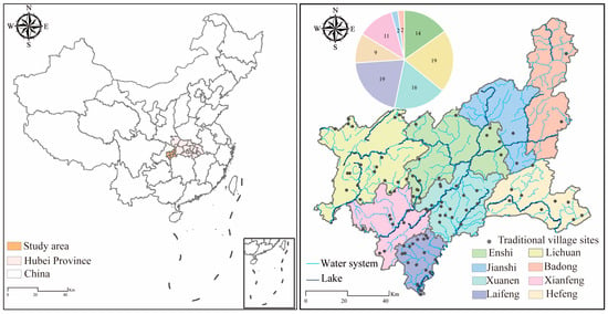
Enshi Tujia and Miao Autonomous Prefecture is located in southwestern Hubei Province, bordering Jingchu in the east, Xiaoxiang in the south, Chongqing and Guizhou in the west, and Shennongjia in the north (Figure 2) [35]. The prefecture has a total area of 24,000 km2. As of 2025, Enshi Prefecture administers two county-level cities and six counties, with a permanent resident population of 33,772 million [36]. The terrain of Enshi is predominantly mountainous, characterized by a typical karst landscape, with over 70% of the area at elevations above 800 m, resulting in a spatial pattern of crisscrossing gullies and ravines [37]. From a macro-ecological perspective, Enshi Prefecture is located in the upper reaches of the Qingjiang River and the mainstream of the Yangtze River within the Yangtze River Basin, constituting an important part of the “upper-reach ecological barrier” of the Yangtze River Economic Belt [38]. The forest vegetation and wetlands surrounding the villages provide key ecological services, including water yield, soil conservation, and biodiversity maintenance, thereby affecting the ecological security of the Qingjiang River Basin and the mainstream of the Yangtze River. The high-altitude, humid subtropical climate of Enshi Prefecture has shaped its ecological support system, whose uniqueness directly influences the production, living practices, and ecological perceptions of local villagers [39]. This superimposition of ecological barrier functions and the livelihood demands of human settlements makes the traditional villages of Enshi Prefecture a typical sample for studying the co-evolution of mountain ecosystems and human activities [40]. According to the six batches of national-level traditional villages announced between 2012 and 2022, Enshi Prefecture in Hubei Province has 92 villages included in the list, accounting for 24.9% of the total number of national-level traditional villages in Hubei Province (370 villages) and 8.3% of the total in the Wuling Mountain area [15]. This makes Enshi Prefecture one of the core distribution areas of traditional villages in Hubei Province.
Figure 2.
Numerical distribution of traditional villages in the Enshi Prefecture.
2.2. Data Sources
In this work, a large amount of data was analyzed to determine the factors affecting structural changes in the land use around the villages. Digital elevation model (DEM) data (resolution 30 m × 30 m) were obtained from the National Earth System Science Data Sharing Platform, and the slope was obtained from the digital elevation model (DEM) data. Construction land and cultivated land data were extracted from remote sensing land-use data for 1990, 2000, 2010, and 2020 from the Resource and Environment Science and Data Center of the Chinese Academy of Sciences (http://www.resdc.cn/). The land use data covered from 1990 to 2020, with a spatial resolution of 30 m. The GDP data were derived from the GDP statistics of the county administrative area where the grid unit was located, weighted by the standardized land-use types and resident-density GDP. Using the resampling technique, all data were standardized at a uniform resolution of 30 m. The traditional village data in this paper came from the Global Change Scientific Research Data Release System, and the village coordinates were extracted from the six batches of Chinese traditional village lists released by the Ministry of Housing and Urban-Rural Development, the Ministry of Culture, and the Ministry of Finance.
2.3. Quantitative Analysis of the Spatial Distribution of Traditional Villages
2.3.1. Kernel Density Estimation
In order to reveal the overall evolutionary trend and morphological characteristics of traditional villages in the Enshi Autonomous Prefecture, this study uses the Kernel Density Estimation (KDE) method to depict the distribution pattern of traditional villages. KDE is a non-parametric estimation method that can smooth the estimation of the probability density function of sample data without relying on assumptions about the distribution of the variables. It is widely used in the analysis of spatiotemporal distribution and evolution trends. The general form of one-dimensional kernel density estimation is as follows [41]:
In the formula, represents the estimated probability density value at position x; n is the sample size; h is the bandwidth parameter, which controls the smoothness of the kernel function; a small value of h leads to overly rough estimation results, while a large value may mask the local structure; and is the mean. K is the kernel function, and in this paper, the Gaussian kernel function is selected.
2.3.2. Landscape Pattern Assessment
The landscape index can represent highly condensed information about landscape patterns and is a simple quantitative indicator that reflects certain characteristics of the landscape’s structural composition and spatial configuration. By calculating traditional village patches using the landscape pattern index method, the relationship between traditional village forms and spatial patterns across different years and locations in the Enshi Autonomous Prefecture can be quantitatively described [42]. This study focuses on three aspects of traditional villages: size, shape, and spatial configuration. Eight landscape pattern indices (Table 1) were selected, and the index calculations were completed in the Fragstats 4.2 software.
Table 1.
Selection of landscape pattern indices.
2.3.3. The Establishment of a Buffer Zone
Buffer analysis is a technique for creating a buffer area based on points, lines, or planes in a geographic location by a specified distance or range. These buffer areas can be used to analyze and predict the features, resource distribution, and potential risks around a location [43]. The diffusion distance determines the influence range and mutual gravity of the point, and it is generally believed that the closer to the central point, the greater the impact. The impact of traditional villages on their surroundings can be measured by establishing buffer zones [44]. In order to further explore the influence of traditional villages on each variable and combine the area and precision of the study area, we established buffers in the ArcGIS 10.8 software with the village point as the center and r as the radius (r = 2 km) and extracted the values of different explanatory variables within the buffer for analysis.
2.4. Field Survey and Questionnaire Collection
The field survey was conducted in Enshi Prefecture, Hubei Province, over a period of two months. Data were collected through a combination of online and offline methods. Offline, we carried out face-to-face interviews and questionnaire surveys with villagers in multiple traditional villages across the prefecture. Online, questionnaires were distributed via the Wenjuanxing platform, and respondents were screened based on their IP location to ensure they were residents of the targeted villages. The questionnaire was structured into several sections, covering respondents’ basic demographic information, their perceptions of topographic constraints, social governance, government regulation, and economic development, as well as their willingness to participate in land-use structure change. Key questions employed a five-point Likert scale to measure residents’ attitudes toward specific land-use practices, perceived policy legitimacy, and intention to modify land-use behavior. A total of 205 valid questionnaires were collected. The complete questionnaire is provided in the Supplementary Materials.
For the spatial analysis of human activities and land-use influences, a 2 km buffer zone was defined around each village settlement. This distance was selected based on the local specificity of the mountainous terrain in Enshi Prefecture. Steep slopes, rugged topography, and limited accessibility substantially restrict the daily mobility range of residents. Field observations and the analysis of local land-use patterns indicate that the majority of villagers’ routine activities, including farming, water collection, fuelwood gathering, and social interactions, are concentrated within a 2 km radius of their homes. Therefore, the 2 km buffer adequately captures the spatial extent of anthropogenic pressures and land-use dynamics that directly shape the village-level land-use structure, ensuring that the derived spatial metrics (e.g., ratios of construction land and cultivated land, road density) accurately reflect the perceived and actual intensity of human activities.
2.5. Structural Equation Model
2.5.1. Selection of Driving Factors
To capture natural constraints, topographic heterogeneity, measured by elevation and slope, was selected. Elevation governs temperature regimes, vegetation zonation, and the vertical distribution of agricultural and settlement patterns, while slope directly determines soil erosion risk, cultivation feasibility, and construction costs. Human activities were captured through four indicators. Road density reflects spatial accessibility and the penetration of infrastructure into previously remote areas, a primary mechanism driving land-use conversion. Population density represents demographic pressure on land resources and the demand for residential and agricultural space. Fixed asset investment captures capital-driven land transformation. Economic development was operationalized through five indicators. Per capita GDP reflects the overall level of regional economic output and development stage, which strongly correlates with land-use intensity. Rural residents’ disposable income captures household-level economic capacity, which shapes individual land-use decisions such as farmland management, crop selection, and participation in off-farm activities. Night-time light intensity serves as an integrated proxy for economic agglomeration, urbanization intensity, and infrastructure density, all of which drive land-use structural change. The proportion of primary and secondary industries captures sectoral composition, which directly governs the allocation of land among agricultural, industrial, and urban uses. Agricultural industrial structure reflects the internal composition of the agricultural sector itself, influencing land-use allocation within agricultural landscapes. The social level was measured by two indicators. The proportion of environmental protection expenditures in total fiscal expenditures reflects governmental commitment to ecological governance and its regulatory influence on land-use outcomes, as higher environmental spending is typically associated with stricter land-use regulation and more investment in ecological restoration. Landscape pattern indices serve as synthetic metrics that capture the spatial configuration of land use and provide diagnostic feedback linking spatial patterns to socio-economic processes.
2.5.2. Calculation of Drivers of Land Use Change
To gain a deeper understanding of residents’ intentions and participation levels in the land-use change process of traditional villages in Enshi Autonomous Prefecture, Hubei Province, this study designed and conducted a comprehensive questionnaire survey. The survey was primarily conducted through semi-structured interviews and online platforms to ensure efficient and comprehensive data collection. A total of 205 valid questionnaires were recovered, covering traditional villages in Enshi Autonomous Prefecture. Given that the questionnaire covered some professional topics related to modern urban development and ecological protection, farmers with no education might have difficulty answering. Therefore, residents with certain educational levels, as well as agricultural managers and technicians, were selected as respondents to ensure the validity and accuracy of the data. The sample size ensured the universality and reliability of the research results. The questionnaire collection strictly adhered to personal information protection laws and regulations; all data were anonymized and used solely for research purposes. The collected questionnaire data underwent strict quality control and preprocessing to eliminate invalid and incomplete responses. Data coding and statistical analysis were conducted using SPSS 25.0 to ensure the accuracy and scientific rigor of the analysis. The Structural Equation Model (SEM) is a multivariate statistical tool that integrates factor analysis and path analysis [45]. The associations among various parts of the model can be depicted through the covariance matrix of variables, covering latent variables, observed variables, and measurement errors, as well as the covariance relationships among them, and decomposing the direct, indirect, and total effects of independent variables on dependent variables [46]. SEM was used in this study to further analyze the driving factors influencing land-use landscape change in traditional villages of the Enshi Autonomous Prefecture, based on residents’ intentions. The calculation steps are as follows [47]:
In the equation, represents the exogenous latent variable; and respectively represent the path coefficient matrices of the exogenous latent variable and the endogenous latent variable; X represents the observed variable of the endogenous latent variable; Y represents the observed variable of the exogenous latent variable; and represent the loading coefficient matrices between the observed variables and the endogenous and exogenous latent variables; represents the endogenous latent variable; and , , and represent the residuals.
3. Results
3.1. The Spatial Distribution Characteristics of Traditional Villages
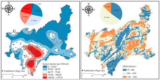
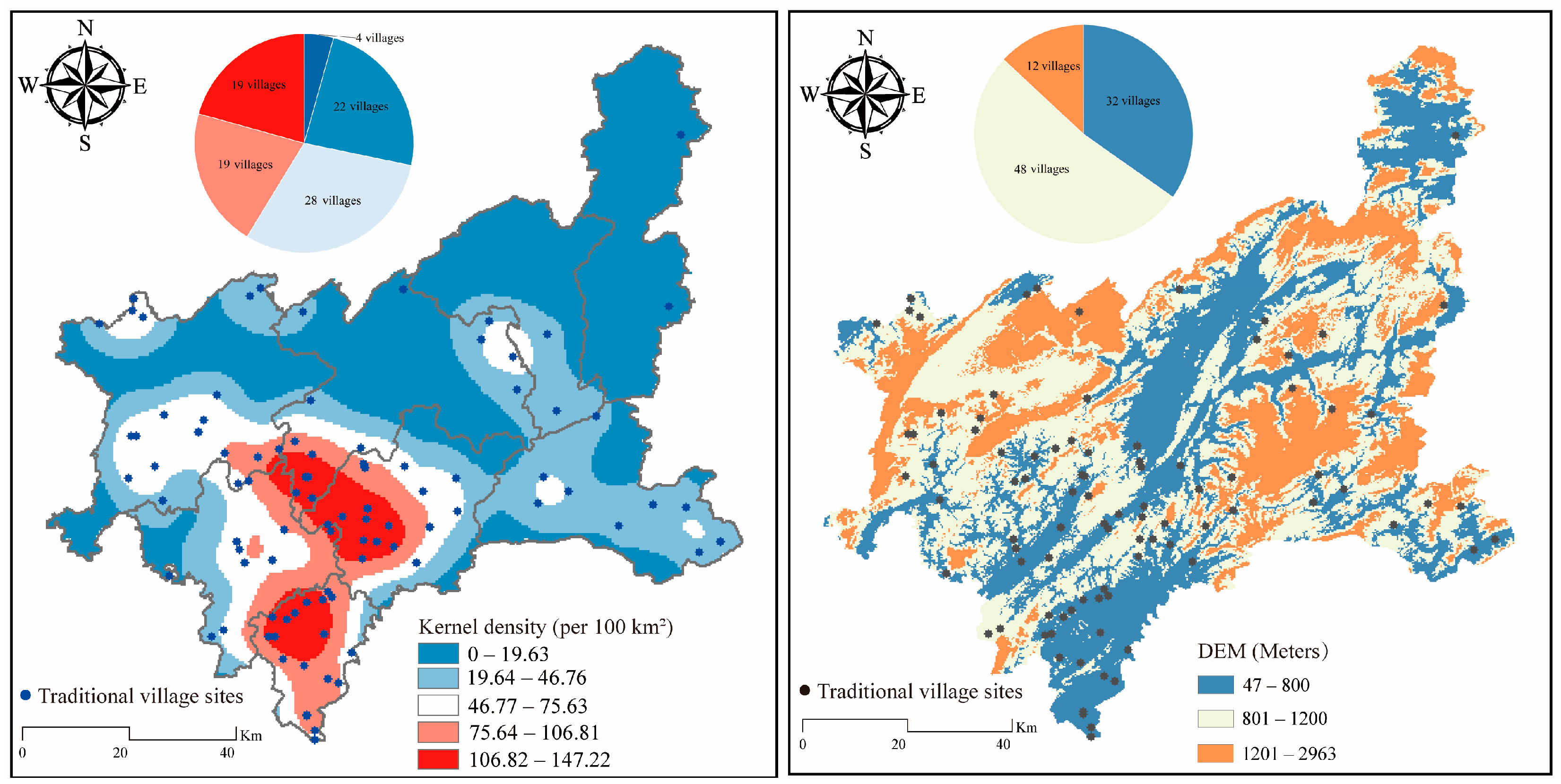
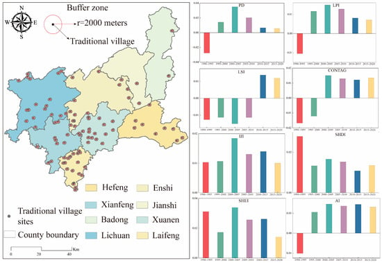
Overlaying the traditional village distribution with elevation data reveals that traditional villages in Enshi Prefecture are mainly concentrated in the mountainous junction of the Wuling and Dalou Mountains, where limited economic development reduces external interference and supports their preservation (Figure 3). Villages at altitudes of 800–1200 m account for the largest share (52.2%), those below 800 m account for 34.8%, and those above 1200 m account for only 13%. Tujia traditional villages in Enshi generally occupy low-elevation areas, mostly river valleys, plains, and gentle slopes with abundant water, convenient transportation, and conditions suitable for living and agriculture; above 1200 m, the climate is colder and farming is more difficult. The spatial distribution displays a distinct multi-core clustering pattern driven by specific geographical, historical, and socio-economic factors with strong spatial dependence, rather than uniform or random dispersion. The overall pattern diffuses and attenuates from high-density core areas to low-density peripheries, showing significant spatial heterogeneity. The number of villages follows an olive-shaped distribution across core density levels, with the medium-density zone concentrating the vast majority. The western core cluster lies in central Lichuan City, exhibiting the highest density and widest extent as the largest core area. The central core cluster spans northern Xuan’en, southern Xianfeng, and northeastern Laifeng, forming a contiguous high-density belt and the second largest core. The southeastern core cluster is located in central Hefeng County, constituting a relatively independent high-density patch.
Figure 3.
The spatial distribution characteristics of traditional villages in Enshi.
3.2. Land Use Changes in Traditional Villages
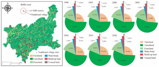
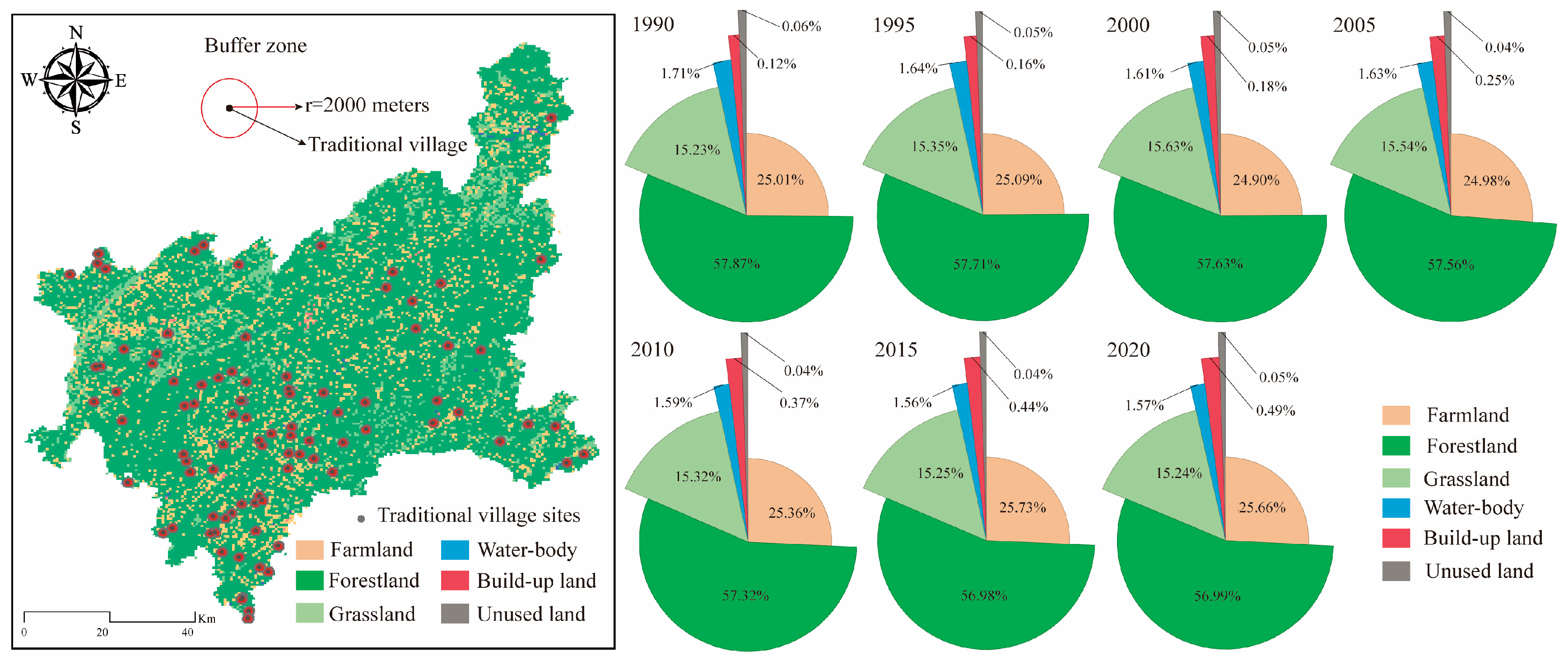
The land-use changes in the traditional village reflect the balance and tension between ecological protection and economic development of this traditional village (Figure 4). The increase in cultivated land is approximately 0.89%, indicating that agriculture still holds an important position in land use in the village, possibly related to the continuous development of rice cultivation and dryland agriculture. The forest area increased from 58.25% to 59.05%, although the increase was small, it was still positive and continuous, suggesting that the forest protection awareness in the traditional village area is strong, or it may be related to the implementation of ecological projects. The grassland area remained basically stable, indicating that animal husbandry accounts for a relatively low proportion in the livelihood of the traditional village. The water body decreased from 1.71% to 1.47%, a reduction of about 14%, it still needs to be monitored for its impact on the traditional ecological agriculture systems, such as the “rice-fish-duck system” of the traditional village.
Figure 4.
Changes in land use structure around traditional villages in 2 km buffers.
3.3. The Changes in the Landscape Pattern of Traditional Villages
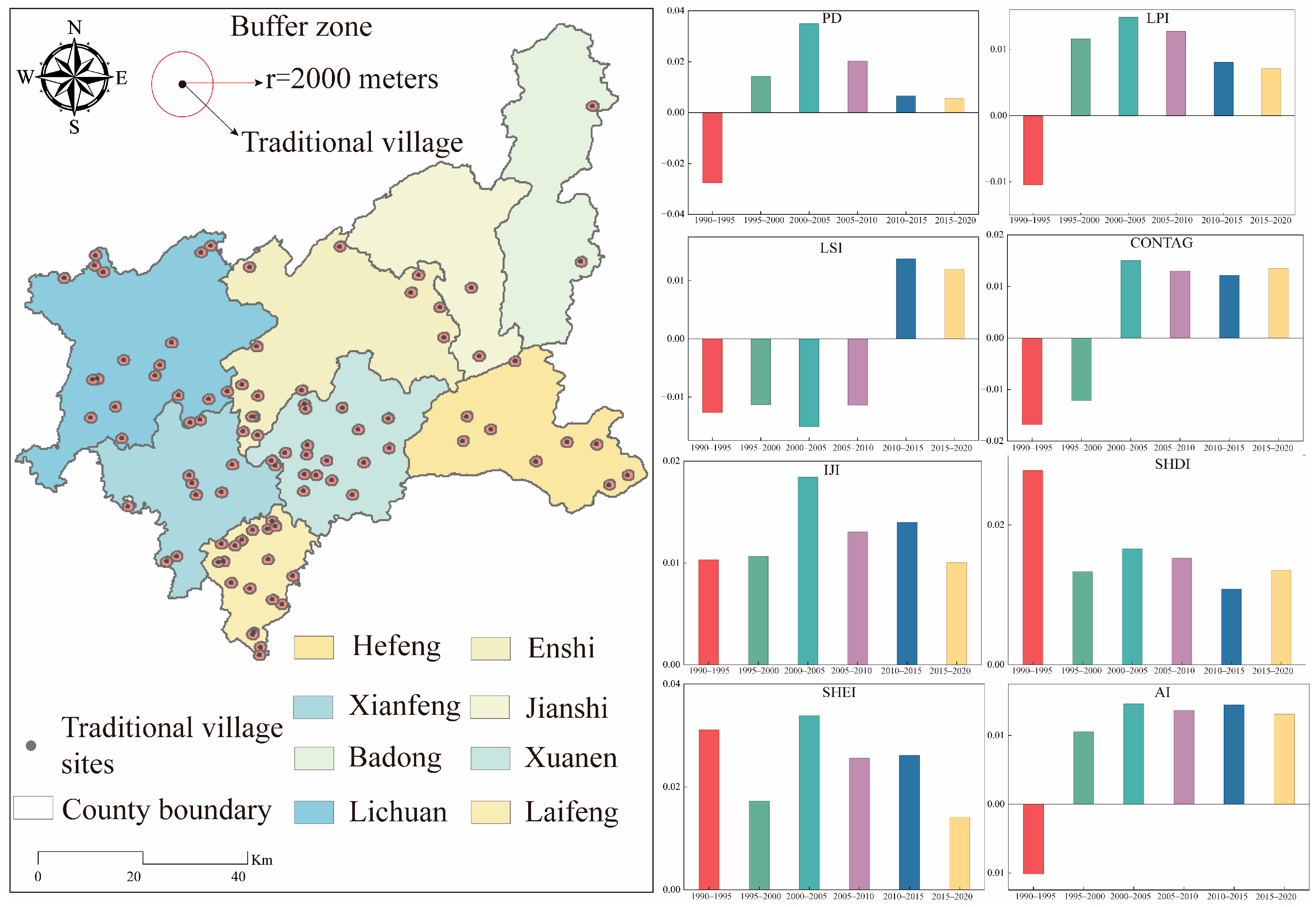
The landscape pattern of the traditional villages showed an evolution trend of “increased fragmentation, fluctuating dominance, decreased connectivity, and increased diversity” from 1990 to 2020, revealing the profound landscape reconfiguration process experienced by this ethnic group between rapid socioeconomic development and traditional culture inheritance (Figure 5). The patch density (PD) remained positively increasing in most periods, with an increase of up to 8.55% in 2015–2020, indicating that landscape fragmentation continued to intensify. This directly corresponds to the reality that rural construction, tourism facility development, and the densification of transportation networks in the traditional village area have led to the division of natural and semi-natural landscapes. The maximum patch index (LPI) fluctuated sharply, reflecting the instability of the size of dominant patches, which was influenced by land use competition and policy adjustments. The landscape shape index (LSI) increased by 1.77% from 2010 to 2015. The spread degree index (CONTAG) showed a continuous and accelerating downward trend, clearly indicating that the overall connectivity of the landscape has deteriorated, and the patch types have tended to be dispersed. This is consistent with the increase in PD, and the dispersion and juxtaposition index (IJI) remained positively increasing, indicating that the adjacency relationship between different landscape types has become more frequent and diverse, which is a direct manifestation of intensified human activities and diversified land use in space. The Shannon diversity index (SHDI) and the uniformity index (SHEI) showed an overall upward trend, indicating that the richness of landscape types and the uniformity of their spatial distribution have been enhanced. To a certain extent, this can be regarded as a spatial mapping of the transformation of the industrial structure in the traditional village area from a relatively single agricultural sector to diversified forms such as tourism services and specialty planting.
Figure 5.
Changes in landscape pattern around traditional villages in 2 km buffers.
3.4. Residents’ Diverse Perceptions in the Land Use Structure Change
3.4.1. Research Hypotheses
This study aims to explore the factors influencing the changes in land use structure in traditional villages of Enshi. In particular, it focuses on the influence of residents on Topographic heterogeneity, Human activities, Economic development and Social level, as well as the interactions among them, and how these interactions affect the willingness of land use structure changes. Based on this study, the following hypotheses are proposed:
Hypothesis 1.
Topographic heterogeneity has a significant negative direct effect on the willingness of land use structure changes, because steeper or more fragmented terrain constrains the feasibility and intensity of land use conversion.
Hypothesis 2.
Human activities have a significant positive direct effect on the willingness of land use structure changes, as increased resident-driven interventions accelerate the transformation of land use patterns.
Hypothesis 3.
Economic development mediates the relationship between Human activities and the willingness of land use structure changes, meaning that higher levels of human activity promote economic growth, which in turn enhances residents’ willingness to alter land use structures.
Hypothesis 4.
Social level mediates the relationship between Economic development and the willingness of land use structure changes, such that improved economic conditions raise social capital and collective decision-making capacity, thereby shaping land use change intentions.
Hypothesis 5.
Topographic heterogeneity moderates the effect of Human activities on the willingness of land use structure changes: in areas with higher topographic heterogeneity, the positive impact of human activities on land use change willingness is significantly weakened due to physical and institutional constraints.
3.4.2. Characteristic Analysis of the Samples
This study collected questionnaire information from a total of 205 residents in traditional villages in Enshi, Hubei Province, through a combination of online and offline methods. The analysis of the basic characteristics of the respondents is as follows: The group aged 31–40 accounted for the highest proportion (38.64%), followed by those aged 20–30 (37.31%), and together they accounted for 75.95% of the sample size, indicating that the respondents were mainly young and middle-aged laborers. In terms of educational level, there was a significant “high-education” feature. There were 120 people with a bachelor’s degree, accounting for 58.54%, occupying the absolute majority; 26 people with a postgraduate degree or above (12.68%); and those with a high school education or below accounted for only 12.77%. This distribution deviates from the usual perception of the educational level of traditional villages. The occupational composition shows a diversified and modern transformation feature. The category of “other” accounted for the highest proportion (36.81%), and considering the actual situation of the ethnic village, this category is likely to cover tourism service providers (such as tour guides, artisans), individual business owners, and new occupations. The next largest category was government officials (21.89%) and students (20.07%), reflecting the active participation of village governance personnel and young students in local development. Among traditional livelihood practitioners, agricultural laborers accounted for 13.10%, and pastoral laborers accounted for 8.13%, totaling 21.23%, which was significantly lower than non-agricultural occupations, directly confirming the trend of the livelihood mode in the study area transitioning from traditional agriculture and animal husbandry to a diversified and composite economy. The distribution of monthly income showed a spindle-shaped structure with a large middle and small ends. Those with an income of less than 4000 yuan and more than 10,001 yuan accounted for 30.68% and 9.62% respectively, and the middle three income segments (4001–10,000 yuan) accounted for 59.70%. This distribution is in line with the basic income level of rural areas in central and western ethnic regions, reflecting the effectiveness of poverty alleviation and also indicating that the overall income level is still in the development stage. The distribution of household registration types was nearly equal (53.57% agricultural household, 46.36% non-agricultural household), reflecting that among the population structure of the ethnic village, local registered residents still account for the majority, but the proportion of non-agricultural households is nearly half.
3.5. Empirical Analysis of Factors Influencing Land Use Structure Change
The overall Cronbach’s value of the questionnaire is 0.86, which exceeds the standard of 0.7, indicating a high degree of internal consistency for all items. Moreover, the Cronbach’s value did not increase even after deleting any items, suggesting that no items need to be deleted. The confirmation factor analysis results show that the ratio of chi-square to degrees of freedom (χ2/df) is less than 3, and the root mean square error of approximation (RMSEA) is less than 0.08. Both of these indicate that the model fits well. Additionally, the comparison of CFI and TLI both exceed 0.9, indicating that this scale has good structural validity (Table 2).
Table 2.
Validation factor model fit indictors.
The results of the convergent validity test (as shown in Table 3) indicate that the factor loadings of all variable items are greater than 0.6. The average extracted variance (AVE) values of all variables range from 0.658 to 0.697, exceeding the threshold of 0.6. The composite reliability (CR) values range from 0.812 to 0.859, exceeding the threshold of 0.7. Therefore, it can be concluded that the convergent validity of the scale data is reliable. And the absolute value of the correlation coefficient between any two potential variables is less than the square root of the AVE corresponding to those potential variables. This indicates that there is a certain degree of distinction among the studied variables, confirming that these five variables are distinct constructs. This further proves the reliability of the discriminant validity of this scale.
Table 3.
Differential validity analysis.
3.6. Analysis of Factors Affecting Land Use Structure
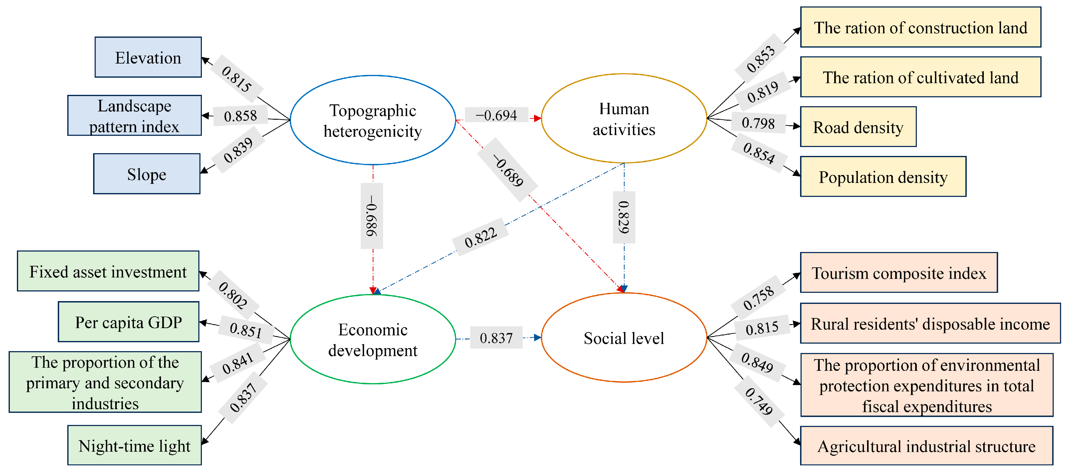
As shown in Figure 6, various factors influencing the changes in land use structure include topographic heterogeneity, human activities, social levels, and economic development. These factors interact with each other through different pathways, jointly influencing the changes in land-use structure, promoting ecological protection and improvement, reducing ecological damage, and ensuring ecological balance and health. Terrain heterogeneity has a significant negative impact on human activities and economic development, with standardized path coefficients of −0.694 and −0.686, respectively, indicating that the higher the regional terrain complexity and the stronger the spatial heterogeneity, the more significant the inhibitory effect on human activities and economic development. This is in line with the constraints of natural geography on human social and economic activities. At the same time, terrain heterogeneity has an indirect negative impact on social levels through human activities (path coefficient −0.689), indicating that terrain heterogeneity limits the intensity of human activities and indirectly affects the regional social development level. Human activities have a significant positive direct impact on social levels, with a standardized path coefficient of 0.829, indicating that the increase in human activity intensity has a significant promoting effect on regional social development. Population concentration, urban development, and transportation improvement, etc., are the core driving forces of social level improvement.
Figure 6.
Structural equation impact factors for land use structure change. The dotted arrows represent the interaction relationship between latent variables, while the solid arrows represent the explanatory effect of the observed variables on their corresponding latent variables.
Human activities impose the negative constraints of terrain heterogeneity and transmit them to social levels, playing a key mediating role between the natural background and social development, and serving as the core hub connecting the natural system and the social system. Economic development has a significant positive direct impact on social levels, with a standardized path coefficient of 0.837, being the most influential direct path in the model, indicating that economic expansion, optimization of the industrial structure, and enhancement of economic vitality directly promote the improvement of social dimensions such as people’s livelihood, tourism development, and ecological protection. At the same time, economic development undertakes the negative constraints of terrain heterogeneity (path coefficient −0.686) and acts positively through the path, forming a synergy with the transmission path of human activities. Moreover, economic development has a significant positive indirect impact on human activities (path coefficient 0.822), indicating that economic development promotes human activities such as urban development and population concentration, further strengthening the driving effect on social levels, forming a multi-path synergy-driven effect.
4. Discussion
4.1. Analysis of the Effects of Factors and the Mechanism
The results (Table 4) indicate that topographic heterogeneity exerts no direct effect on the social development level; rather, its influence is transmitted indirectly through human activities and economic development, yielding significant negative indirect effects. This finding corroborates the threshold constraint theory, which posits that the natural environment imposes limits on socio-economic systems. The indirect effect of Path 1 (via human activities) is −0.576, and that of the economic development pathway is −0.574, a nearly identical magnitude. This symmetry implies that terrain spatial heterogeneity substantially inhibits the social system, whether by constraining human activities or by impeding economic growth. Chain-mediated pathways further reinforce this constraint: Path 6 yields an indirect effect of −0.477 and Path 7 yields −0.468, revealing that topographic heterogeneity generates a superimposed negative transmission through the interplay between human activities and economic development, thereby intensifying the overall constraint on the social system. Consequently, natural geographical conditions constitute the fundamental underlying logic that restricts social development in ethnic traditional villages. Human activities and economic development serve as the core positive drivers of social level enhancement. Path 4 exhibits an indirect effect of 0.693, the highest among all paths, indicating that human activities act as a pivotal nexus that promotes coordinated socio-economic advancement and yields multiplier effects on the social level through economic transmission. Path 5 demonstrates an indirect effect of 0.682, highlighting the foundational driving role of economic development, which not only provides the material basis for human activities but also directly facilitates increases in rural household income, tourism development, and investment in environmental protection. These results confirm that regional economic progress can effectively translate into improvements in social well-being. For ethnic traditional villages, economic development can help overcome the constraints imposed by natural endowments, propelling the social level from low-quality agglomeration toward high-quality enhancement through improved public services, optimized industrial structures, and related pathways.
Table 4.
The indirect effects among the latent variables.
In summary, the evolution of the social level in Enshi traditional villages is driven by the joint action of natural constraints and human-induced factors, forming a complex multi-path causal structure. Topographic heterogeneity acts as a persistent constraint system through multiple pathways, while human activities and economic development together constitute a mutually reinforcing driving system. This interplay between negative and positive indirect effects reflects the dynamic evolution of the human-land relationship: during early stages, natural constraints dominate and social development remains at a low-quality agglomeration stage; as economic growth and urbanization progress, positive driving effects gradually intensify, offset natural limitations, and propel the social level toward high-quality enhancement. The structural equation modeling thus quantitatively elucidates the dual mechanism of natural constraints and anthropogenic driving forces within the traditional village buffer zone, offering both theoretical insights and empirical evidence for understanding the coupled evolution of regional human-land systems.
4.2. Strengths and Limitations of Approaches in Land-Use Research
Land-use patterns are shaped by the interplay of human activities and the natural environment. During the formation of traditional villages, residents’ productive activities modify surrounding land use, while social conditions and policies significantly reshape these patterns. The spatial distribution of villages reflects livability and long-standing human–land relationships. Owing to spatial heterogeneity, broad-scale patterns are strongly governed by geographical conditions [48]. Wang et al. found that while immediate village landscapes in Enshi Prefecture remained stable, prefectural-level analysis revealed accelerating urban growth [49].
Different land-use patterns are linked to the services that ecosystems can provide, further shaping the relationship between humans and nature. For instance, while agriculture-dominated environments can supply food and other products, their landscape patterns tend to be less diverse and may therefore compromise other ecological functions. In mountainous counties, appropriate proportions of forest and grassland are significantly correlated with the spatial heterogeneity of ecosystem service values. Spatiotemporal analysis of LUCC supports the monitoring and investigation of land-use dynamics and characteristics [50]. Moreover, analyses based on landscape metrics have proven effective in quantifying landscape patterns and aiding the design of land management strategies. Different landscape metrics can capture features of landscape patterns such as diversity, composition, and degree of fragmentation [51]. When integrated into spatiotemporal analyses, these metrics serve as indicators of landscape evolution. Under urbanization and farmland conservation, greater attention to the landscape patterns of traditional villages in fragile environments is warranted [52].
The driving factors of traditional village land-use patterns are complex, involving natural conditions, socio-economic forces, and historical–cultural legacies, with spatial variation leading to divergent findings. Most studies have adopted a micro perspective, with limited attention to urban regional scales. Advances in GIS and multivariate statistics have enabled macro-scale investigations. Bedate et al., quantitatively assessed rural morphology in Spain by integrating natural environment, urban and transport locations, and policies [53]. Long et al., identified economic restructuring, urbanization, conceptual shifts, and national policies as primary drivers of spatial morphology [54]. Liu et al. demonstrated institutional forces such as insecure land tenure shaping village-scale land-use change [55]. Murgante and Danese applied spatial statistics to over two decades of data in Potenza, Italy, examining density, distance to infrastructure, and spatial autocorrelation [56]. Zareei employed GIS to model biogas potential from rural waste in Iran [50]. Despite these methodological advances, studies that combine spatial quantitative analysis with primary resident-level data remain limited [57].
Existing studies largely focus on individual villages and thus fail to capture immediate human–land interactions in their surroundings, precisely characterize micro-scale urbanization disturbances to adjacent ecosystems, or deeply integrate quantitative spatial analysis with field-based surveys. To address these gaps, this study takes 92 nationally recognized traditional villages in Enshi Prefecture, Hubei Province, as the sample. By integrating spatial quantitative analysis from geographic information science with questionnaire surveys, it achieves a progressive focus from macro-level analysis of the full sample to micro-level characterization of individual villages. This multi-scalar mixed-methods design captures both broad patterns and local specificities, filling an academic gap in differentiated human–land relationship research and providing a transferable scientific reference for living conservation, rural revitalization, and ecological civilization construction of traditional villages.
4.3. Comprehensive Strategies for Ecological Protection and Suggestions for Policy Optimization
This study proposes a multi-system coupling-based strategy to guide Enshi’s villages toward coordinated ecological, cultural, economic, and livelihood progress, and offers scientific references for protecting traditional villages in mountainous ethnic and ecologically sensitive areas across China, holding significant value for systematic, precise, and sustainable conservation (Figure 7). This study identifies topographic heterogeneity as the core natural constraint significantly negatively affecting human activities and economic development, and indirectly influencing social development and ecosystem health through mediating pathways, thereby determining the ecological security pattern of Enshi’s traditional villages [58]. Enshi’s mountainous terrain, high relief, landscape heterogeneity, and ecological sensitivity make it prone to degradation, erosion, and fragmentation under uncontrolled development [9]. Therefore, a differentiated, ecologically centered protection pattern based on topographic gradients is necessary. In core protection areas, strict controls on development intensity and expansion of construction land and intensive agriculture are needed [59], with classification-based controls according to elevation, slope, and landscape patterns [60]. Ecological restoration, soil-water conservation, and vegetation reconstruction in sensitive areas should be prioritized, reducing disturbance at the source and transforming natural constraints into protective advantages. Human activities mediate between natural and socio-economic systems, and their intensity, distribution, and patterns determine protection effectiveness [61]; while promoting social development, they also pressure ecosystems, and unreasonable activities amplify vulnerability. Hence, precise regulation and an eco-friendly transition are essential [26]. Population, construction, and industries should proceed within reasonable limits to avoid ecological and cultural damage from excessive urbanization. Ecological agriculture, organic farming, and circular planting–breeding models should be promoted to reduce farmland disturbance and non-point source pollution [62]. Wastewater treatment, waste sorting, and clean energy use should advance to improve living environments. Micro-renovation and targeted enhancement in construction should preserve traditional patterns and original features, achieving harmonious coexistence between human activities and ecosystems [63].
Figure 7.
Optimization management and suggestions for land utilization in traditional villages of Enshi.
Economic development is the core driver for resolving the conflict between protection and development, and sustaining long-term ecological protection [64], exerting the strongest positive effect on social development and feeding back into ecological governance through social empowerment. Given Enshi’s weak economic base and homogeneous industrial structure, a development path prioritizing ecology, green growth, and cultural tourism integration is imperative. Low-impact sustainable industries such as under-forest economy, ecological planting and breeding, ethnic cultural tourism, and wellness retreats should be developed to transform ecological advantages into economic benefits [65]. Ecological compensation mechanisms, value realization for ecological products, and green finance policies should be improved, enabling residents to gain a stable income from protection and shifting from “passive protection” to “active guardianship” [66]. Green development should drive livelihood improvements, strengthening protection willingness and forming a virtuous ecology–economy–society cycle.
Improving social governance is fundamental for effective protection. Social development, driven by economic development and human activities, enhances ecological investment, environmental awareness, and community co-governance capacity [67]. Enshi should accelerate a government-led, village-based collaborative governance system with full participation. Ecological protection should be incorporated into village rules, grassroots assessments, and territorial spatial planning [68]. Investment in monitoring, remediation, and public services should increase, and a long-term ecosystem health monitoring and early-warning mechanism should be institutionalized to protect [69]. Policies on ecology, rural revitalization, cultural heritage preservation, and land use control should be integrated to break sectoral barriers and form a coordinated system with clear rights and responsibilities [70].
5. Conclusions
Taking traditional villages in Enshi Tujia and Miao Autonomous Prefecture, Hubei Province, as a typical case, this study systematically investigates the spatial patterns, evolution characteristics, and multi-system coupling driving mechanisms of land use structure change in mountainous ethnic regions by integrating spatial statistics, landscape pattern analysis, and structural equation modeling. The main conclusions are as follows:
The spatial distribution of traditional villages exhibits significant topographic gradient effects and multi-core clustering characteristics. Traditional villages in Enshi Prefecture are mainly distributed in mid-mountain areas at elevations between 800 m and 1200 m, accounting for more than 52%, while villages above 1200 m are relatively few (13%). The overall pattern is an unbalanced “dense in the west, sparse in the east” distribution. This reflects that the location and persistence of traditional villages are jointly shaped by physical geographical units and historical-cultural factors, with strong spatial dependence.
Land use and landscape pattern evolution show ethnically differentiated patterns. Taking the Dong ethnic traditional villages as an example, from 1990 to 2020, cultivated land and forest area increased slightly, grassland remained basically stable, and water bodies decreased slightly. The landscape pattern exhibited continuously increasing fragmentation, decreasing connectivity, and increasing diversity. This “development-oriented” evolution pattern reveals the tension between external development and local protection in traditional villages, and is a spatial mapping of the transformation of the industrial structure from a relatively single agricultural sector towards diversified forms such as tourism services and specialty planting.
Topographic heterogeneity is the core natural constraint governing land use structure change. The structural equation model confirms that topographic heterogeneity has significant negative direct effects on both human activities (standardized path coefficient −0.694) and economic development (−0.686). It also indirectly affects the social level through two mediating chains. This indicates that complex and rugged terrain not only directly restricts development intensity but also indirectly constrains social development by inhibiting economic agglomeration and population activities, constituting the underlying constraint of the ecological security pattern in mountainous ethnic regions. Human activities and economic development constitute dual core pathways driving social level improvement. The direct positive effect of human activities on the social level is 0.829, and the direct positive effect of economic development on the social level is 0.837, the latter being the strongest path in the model.
This study encompassed multiple villages across Enshi Prefecture, Hubei Province, integrating structured questionnaire surveys with fine-scale remote sensing data to achieve macro-level coverage and micro-level mechanistic depth. Second, although topographic constraints, human activities, social level, and economic development have all been recognized as important factors influencing land-use behavior, they have rarely been examined simultaneously using primary survey data from mountainous traditional villages; this study integrates these four dimensions within a unified analytical framework. Third, existing methods have largely relied on remote sensing or macro-policy analysis, neither of which captures the mediating factors that shape policy effectiveness on the ground; this study accesses long-accumulated ecological knowledge, community norms, and perceptions of local governance—factors that are critical for behavioral uptake. By providing field-validated primary evidence on residents’ perceptions and willingness to participate, this study lays the foundation for designing land-use interventions that combine ecological effectiveness with local legitimacy.
Supplementary Materials
The following supporting information can be downloaded at: https://www.mdpi.com/article/10.3390/land15071189/s1. Which contain the relevant questions of this survey questionnaire.
Author Contributions
Conceptualization, Y.B. and L.G.; methodology, H.Q. and W.W.; validation, formal analysis, investigation, H.Q. and W.W.; writing—original draft preparation, H.Q.; writing—review and editing, H.Q. and Y.B. All authors have read and agreed to the published version of the manuscript.
Funding
This research was funded by the National Key R&D Program of China (2023YFE0112804).
Institutional Review Board Statement
The study was conducted in accordance with the Declaration of Helsinki, and the protocol was approved by the Research Institute of Forestry, Chinese Academy of Forestry on 25 June 2026.
Data Availability Statement
The data that support the findings of this study are available from the corresponding author upon reasonable request.
Conflicts of Interest
The authors declare no conflicts of interest.
References
- Ma, S.; Wang, L.J.; Jiang, J.; Zhao, Y.G. Land use/land cover change and soil property variation increased flood risk in the black soil region, China, in the last 40 years. Environ. Impact Assess. Rev. 2024, 104, 107314. [Google Scholar]
- Wen, X.Y.; Liu, T.T.; Wang, Z.J. Assessment of ecological security risk in rocky desertification area based on land-use change model. Ecol. Indic. 2023, 156, 111000. [Google Scholar] [CrossRef] [Scilit]
- Shen, F.X.; Yang, L.; Zhang, L.; Guo, M.; Huang, H.L.; Zhou, C.H. Quantifying the direct effects of long-term dynamic land use intensity on vegetation change and its interacted effects with economic development and climate change in jiangsu, China. J. Environ. Manag. 2023, 325, 116562. [Google Scholar]
- Ma, H.D.; Tong, Y.Q. Spatial differentiation of traditional villages using ArcGIS and GeoDa: A case study of Southwest China. Ecol. Inform. 2022, 68, 101416. [Google Scholar]
- Zhang, J.; Zhang, R.N.; Li, Q.L.; Zhang, X.; He, X. Spatial Sifferentiation and Differentiated Development Paths of Traditional Villages in Yunnan Province. Land 2023, 12, 1663. [Google Scholar] [CrossRef] [Scilit]
- Kim, D.H. A Study on Backgrounds and Characteristics of Folk Village Formation Based on Cases of Traditional Villages in Korea and China. J. Resid. Environ. Inst. Korea 2021, 19, 293–314. [Google Scholar] [CrossRef] [Scilit]
- Huang, C.; Qiu, J.; Huang, T.M. Mode selection of post-earthquake recovery and reconstruction of traditional villages using dependency analytic process: Taking Xiluo-Buzi village in the 2022 M6.8 Luding earthquake as an example. Front. Public Health 2023, 11, 1240573. [Google Scholar] [PubMed]
- Wang, L.L.; Wang, Y.X.; Huang, W.C.; Han, J. Analysis Methods for Landscapes and Features of Traditional Villages Based on Digital Technology-The Example of Puping Village in Zhangzhou. Land 2024, 13, 1539. [Google Scholar]
- Chen, X.H.; Xie, W.Z.; Li, H.B. The spatial evolution process, characteristics and driving factors of traditional villages from the perspective of the cultural ecosystem: A case study of Chengkan Village. Habitat Int. 2020, 104, 102250. [Google Scholar] [CrossRef] [Scilit]
- Liu, M.X.; Dong, X.B.; Zhang, Y.F.; Wang, X.C.; Wei, H.J.; Zhang, P.; Zhang, Y. Spatiotemporal changes in future water yield and the driving factors under the carbon neutrality target in Qinghai. Ecol. Indic. 2024, 158, 111310. [Google Scholar]
- Ma, Y.; Zhang, Q.L.; Huang, L.Y. Spatial distribution characteristics and influencing factors of traditional villages in Fujian Province, China. Humanit. Soc. Sci. Commun. 2023, 10, 883. [Google Scholar] [CrossRef] [Scilit]
- Wei, K.X.; He, Y.X.; Wang, M.Q.; Zhu, R.; Wang, Z.X. Identification, inheritance and restoration of traditional village landscape gene: A case study of Lidipo Village in Tongchuan, Shaanxi Province. npj Herit. Sci. 2025, 13, 18. [Google Scholar] [CrossRef] [Scilit]
- Li, B.H.; Yang, F.D.; Long, X.Y.; Liu, X.Y.; Cheng, B.; Dou, Y.D. The organic renewal of traditional villages from the perspective of logical space restoration and physical space adaptation: A case study of Laoche village, China. Habitat Int. 2024, 144, 102988. [Google Scholar] [CrossRef] [Scilit]
- Wang, D.; Wei, X.D.; Yan, X.Q.O. Sohaib, A Study on Sustainable Design of Traditional Tujia Village Architecture in Southwest Hubei, China. Buildings 2024, 14, 128. [Google Scholar]
- Liu, X.H.; Yuan, L.; Tan, G.Y. Identification and Hierarchy of Traditional Village Characteristics Based on Concentrated Contiguous Development-Taking 206 Traditional Villages in Hubei Province as an Example. Land 2023, 12, 471. [Google Scholar] [CrossRef] [Scilit]
- Tan, G.Y.; Zhu, J.K.; Chen, Z.X. Deep learning based identification and interpretability research of traditional village heritage value elements: A case study in Hubei Province. Herit. Sci. 2024, 12, 200. [Google Scholar] [CrossRef] [Scilit]
- Yuan, L.; Xu, L.Q.; Zhang, Z.T.; Xu, Y. Traditional village clustered protection and utilization methods based on network science. npj Herit. Sci. 2025, 13, 140. [Google Scholar] [CrossRef] [Scilit]
- Zhang, X.F.; Zhou, L.J.; Zhou, T.F. Quantitative analysis of spatial gene in traditional villages: A case study of Korean traditional villages in Northeast China. J. Asian Archit. Build. Eng. 2025, 24, 2577–2588. [Google Scholar]
- Plata-Rocha, W.; Monjardin-Armenta, S.A.; Pacheco-Angulo, C.E.; Rangel-Peraza, J.G.; Franco-Ochoa, C.; Mora-Felix, Z.D. Proximate and Underlying Deforestation Causes in a Tropical Basin through Specialized Consultation and Spatial Logistic Regression Modeling. Land 2021, 10, 186. [Google Scholar] [CrossRef] [Scilit]
- Jiang, S.M.; Feng, F.; Zhang, X.N.; Xu, C.Y.; Jia, B.Q.; Lafortezza, R. Driving factors of fragmentation in urban landscapes: Local contributions, spatial relationships, and causal effects. Ecol. Indic. 2025, 174, 113454. [Google Scholar] [CrossRef] [Scilit]
- Anato, N.J.; Chen, J.; Tang, A.P.; Assogba, O.C. Numerical Investigation of Ground Settlements Induced by the Construction of Nanjing WeiSanLu Tunnel and Parametric Analysis. Arab. J. Sci. Eng. 2021, 46, 11223–11239. [Google Scholar]
- Zheng, Q.H.; Chen, W.; Li, S.L.; Yu, L.; Zhang, X.; Liu, L.F.; Singh, R.P.; Liu, C.Q. Accuracy comparison and driving factor analysis of LULC changes using multi-source time-series remote sensing data in a coastal area. Ecol. Inform. 2021, 66, 101457. [Google Scholar]
- Yang, C.B.; Yan, F.Q.; Lei, X.L.; Ding, X.L.; Zheng, Y.; Liu, L.F.; Zhang, S.W. Investigating Seasonal Effects of Dominant Driving Factors on Urban Land Surface Temperature in a Snow-Climate City in China. Remote Sens. 2020, 12, 3006. [Google Scholar] [CrossRef] [Scilit]
- Su, Y.; Chen, X.Y.; Almodovar-Melendo, J.M. A Comparative Analysis of Preservation and Revitalization Policies for Traditional Villages in China and Italy. Buildings 2025, 15, 3515. [Google Scholar] [CrossRef] [Scilit]
- Bera, D.; Chatterjee, N.D.; Dinda, S.; Ghosh, S.; Bera, S.; Mandal, M.; Dhiman, V.; Kashyap, A.; Zhran, M. Evaluating the Impact of Diverse Driving Factors on Carbon Stock Variability in Tropical Dry Deciduous Forests of West Bengal, India. Environ. Manag. 2025, 75, 3601–3615. [Google Scholar] [CrossRef] [Scilit]
- Wang, N.F.; Chen, X.P.; Zhang, Z.L.; Pang, J.X. Spatiotemporal dynamics and driving factors of county-level carbon storage in the Loess Plateau: A case study in Qingcheng County, China. Ecol. Indic. 2022, 144, 109460. [Google Scholar] [CrossRef] [Scilit]
- Byun, K.H. The Awareness of Tradition and Environmentally Friendly Elements in Traditional Villages near the Center of Gangneung, Korea. J. Asian Archit. Build. Eng. 2015, 14, 137–144. [Google Scholar] [CrossRef] [Scilit]
- Liu, W.X.; Meng, Q.Y.; Allam, M.; Zhang, L.L.; Hu, D.; Menenti, M. Driving Factors of Land Surface Temperature in Urban Agglomerations: A Case Study in the Pearl River Delta, China. Remote Sens. 2021, 13, 2858. [Google Scholar] [CrossRef] [Scilit]
- Wang, W.W.; Zhang, F.; Zhao, Q.; Liu, C.J.; Jim, C.Y.; Johnson, V.C.; Tan, M.L. Determining the main contributing factors to nutrient concentration in rivers in arid northwest China using partial least squares structural equation modeling. J. Environ. Manag. 2023, 343, 118249. [Google Scholar] [CrossRef] [Scilit]
- Zhang, H.; Luo, J.A.; Wu, J.Y.; Dong, H.T. Dynamic response of carbon storage to future land use/land cover changes motivated by policy effects and core driving factors. J. Plant Ecol. 2024, 17, rtae042. [Google Scholar] [CrossRef] [Scilit]
- Zhu, Y.Y.; Ling, G.H.T. Driving forces and prediction of urban open spaces morphology: The case of Shanghai, China using geodetector and CA-Markov model. Ecol. Inform. 2024, 82, 102763. [Google Scholar] [CrossRef] [Scilit]
- Lv, G.Y.; Li, X.; Fang, L.; Peng, Y.B.; Zhang, C.X.; Yao, J.Y.; Ren, S.L.; Chen, J.Y.; Men, J.; Zhang, Q.Z.; et al. Disentangling the Influential Factors Driving NPP Decrease in Shandong Province: An Analysis from Time Series Evaluation Using MODIS and CASA Model. Remote Sens. 2024, 16, 1966. [Google Scholar] [CrossRef] [Scilit]
- Huang, X.; Huang, X.J.; Liu, M.M.; Wang, B.; Zhao, Y.H. Spatial-temporal Dynamics and Driving Forces of Land Development Intensity in the Western China from 2000 to 2015. Chin. Geogr. Sci. 2020, 30, 16–29. [Google Scholar] [CrossRef] [Scilit]
- Zhang, X.Y.; Zhou, Y.Z.; Long, L.L.; Hu, P.; Huang, M.Q.; Chen, Y.C.; Chen, X.Y. Prediction of the spatiotemporal evolution of vegetation cover in the Huainan mining area and quantitative analysis of driving factors. Environ. Monit. Assess. 2023, 195, 776. [Google Scholar] [CrossRef] [Scilit] [PubMed]
- Li, D.Y.; Li, T.T.; Wu, J.Y.; Zhang, M.; Wang, Z.X. Potential Distribution Modeling and Conservation Gap Identification for Rare and Endangered Plant Species: A Case Study of 10 Species in Hubei Province. Ecol. Evol. 2025, 15, e72672. [Google Scholar] [CrossRef] [Scilit] [PubMed]
- Cheng, J.; Huang, C.B.; Gan, X.T.; Peng, C.H.; Deng, L. Can forest carbon sequestration offset industrial CO2 emissions? A case study of Hubei Province, China. J. Clean. Prod. 2023, 426, 139147. [Google Scholar] [CrossRef] [Scilit]
- Liu, W.P.; Yu, P.M. Quantifying synergistic effects of multi-temporal ecosystem service bundles for degraded ecosystem restoration: A case study in Hubei Province, China. Environ. Res. Lett. 2023, 18, 094003. [Google Scholar] [CrossRef] [Scilit]
- Liu, J.Y.; Zhou, Y.; Wang, L.; Zuo, Q.; Li, Q.; He, N. Spatiotemporal Analysis and Multi-Scenario Prediction of Ecosystem Services Based on Land Use/Cover Change in a Mountain-Watershed Region, China. Remote Sens. 2023, 15, 2759. [Google Scholar]
- Long, X.J.; Zhang, H.M.; Liu, H.; Wang, Z.K.; Zeng, L.H.; Huang, X.Y.; Chen, X. Components of dissolved organic carbon in relation to environmental factors in lakes along an altitudinal gradient in central China. Environ. Monit. Assess. 2024, 196, 846. [Google Scholar] [CrossRef] [Scilit] [PubMed]
- He, N.; Zhou, Y.; Wang, L.; Li, Q.; Zuo, Q.; Liu, J.Y.; Li, M.Y. Spatiotemporal evaluation and analysis of cultivated land ecological security based on the DPSIR model in Enshi autonomous prefecture, China. Ecol. Indic. 2022, 145, 109619. [Google Scholar] [CrossRef] [Scilit]
- Pang, D.Y.; Zhao, M.Y.; Hu, Y.X.; Cai, L.P.; Liu, X.; Zhao, W.W. Ecosystem health assessment and driver analysis in the Otindag Sandy Land, China. Ecol. Front. 2025, 45, 1397–1406. [Google Scholar] [CrossRef] [Scilit]
- Adams, H.; Leroux, S.J. Integrating Field Data and a Meta-ecosystem Model to Study the Effects of Multiple Terrestrial Disturbances on Small Stream Ecosystem Function. Ecosystems 2024, 27, 951–968. [Google Scholar] [CrossRef] [Scilit]
- Sylla, M. Ecosystem Services Contributing to Local Economic Sectors—Conceptual Framework of Linking Ecosystem Services, Benefits and Economic Sectors. Econ. Environ. 2023, 85, 52–67. [Google Scholar] [CrossRef] [Scilit]
- Zhou, S.B.; Huang, Y.Y.; He, H.; Zhang, Z.X. Focusing on structural changes and future risks of ecosystems: An opportunity-cost based ecosystem service account for riparian ecosystems and its case study. Ecol. Indic. 2024, 158, 111523. [Google Scholar] [CrossRef] [Scilit]
- Cudjoe, D.; Zhang, H.M.; Wang, H. Predicting residents’ adoption intention for smart waste classification and collection system. Technol. Soc. 2023, 75, 102381. [Google Scholar] [CrossRef] [Scilit]
- Sun, Z.H.; Li, Y.F.; Gao, S.K. Residents’ Cognition, Attitudes, and Intentions to Participate in Long-Term Care Insurance: Moderating Effect of Policy Support. Behav. Sci. 2024, 14, 895. [Google Scholar] [CrossRef] [Scilit] [PubMed]
- Leicht, T.; Giovanardi, M.; Darler, W.; Kavaratzis, M. The Role of Resident-Place Identification in Mediating Consumption Localism and Mobility Intentions. J. Reg. Sci. 2025, 65, 518–534. [Google Scholar]
- Tao, W.; Chen, H.; Lin, J. Spatial form and spatial cognition of traditional village in syntactical view: A case study of Xiaozhou Village, Guangzhou. Acta Geogr. Sin. 2013, 68, 209–218. [Google Scholar]
- Wang, L.Q.; Wen, C. Traditional Villages in Forest Areas: Exploring the Spatiotemporal Dynamics of Land Use and Landscape Patterns in Enshi Prefecture, China. Forests 2021, 12, 65. [Google Scholar] [CrossRef] [Scilit]
- Peng, J.; Liu, Y.; Li, T.; Wu, J. Regional ecosystem health response to rural land use change: A case study in Lijiang City, China. Ecol. Indic. 2017, 72, 399–410. [Google Scholar] [CrossRef] [Scilit]
- Wang, Y.; Dai, E.; Yin, L.; Ma, L. Land use/land cover change and the effects on ecosystem services in the Hengduan Mountain region, China. Ecosyst. Serv. 2018, 34, 55–67. [Google Scholar] [CrossRef] [Scilit]
- Statuto, D.; Cillis, G.; Picuno, P. Analysis of the effects of agricultural land use change on rural environment and landscape through historical cartography and GIS tools. J. Agric. Eng. 2016, 47, 28. [Google Scholar] [CrossRef] [Scilit]
- Bedate, A.; Herrero, L.C.; Sanz, J.Á. Economic valuation of the cultural heritage: Application to four case studies in Spain. J. Cult. Herit. 2004, 5, 101–111. [Google Scholar] [CrossRef] [Scilit]
- Long, H.; Zou, J.; Pykett, J.; Li, Y. Analysis of rural transformation development in China since the turn of the new millennium. Appl. Geogr. 2011, 31, 1094–1105. [Google Scholar] [CrossRef] [Scilit]
- Liu, Y.; Yang, R.; Long, H.; Gao, J.; Wang, J. Implications of land-use change in rural China: A case study of Yucheng, Shandong province. Land Use Policy 2014, 40, 111–118. [Google Scholar] [CrossRef] [Scilit]
- Murgante, B.; Danese, M. Urban Versus Rural: The Decrease of Agricultural Areas and the Development of Urban Zones Analyzed with Spatial Statistics. Int. J. Agric. Environ. Inf. Syst. (IJAEIS) 2011, 2, 16–28. [Google Scholar]
- Zareei, S. Evaluation of biogas potential from livestock manures and rural wastes using GIS in Iran. Renew. Energy 2018, 118, 351–356. [Google Scholar] [CrossRef] [Scilit]
- Jia, H.D.; Li, L.B.; Wu, S.Y.; Zhao, R.Q.; Yang, H. The Spatial Distribution Characteristics and Driving Factors of Traditional Villages’ Tourism Transformation Level in Shaanxi, China. Land 2025, 14, 1602. [Google Scholar] [CrossRef] [Scilit]
- Liang, Q.B.; Pan, Z.; Huang, Y.H.; Zheng, L.; Fang, J.Y.; Qin, Y.R.; Zhu, Y.F.; Kang, L.L.; Chen, Y.L. Distribution and driving factors of settlement heritage of coastal peninsulas via GIS: Evidence from Shandong, China. Front. Earth Sci. 2025, 13, 1735907. [Google Scholar] [CrossRef] [Scilit]
- Liu, L.; Xu, J.; Zhang, Z.; Bi, Y.X. Assessing the digital village development in China and its driving factors: An analysis using online media data. Habitat Int. 2026, 168, 103707. [Google Scholar]
- Du, J.C.; Bi, S.B.; Zhang, Y.; Chen, M. Landscape ecological risk assessment and driving factors in Guyi Basin cultural heritage sites: A multi-scenario simulation perspective. npj Herit. Sci. 2026, 14, 36. [Google Scholar] [CrossRef] [Scilit]
- Chen, W.X.; Yang, Z.; Yang, L.Y.; Wu, J.H.; Bian, J.J.; Zeng, J.; Liu, Z.L. Identifying the spatial differentiation factors of traditional villages in China. Herit. Sci. 2023, 11, 149. [Google Scholar] [CrossRef] [Scilit]
- Sun, Y.; Chen, C.; Yang, H.H. Exploring the spatial patterns of rural multifunctionality in China’s metropolitan hinterland and its driving forces: The case of Shanghai-Suzhou-Jiaxing-Huzhou region. Habitat Int. 2025, 165, 103562. [Google Scholar]
- Sun, Y.R.; Li, X.J.; Luo, J.; Tian, L.L. Evolution and driving mechanism of rural settlements in traditional plain agricultural areas from the perspective of migrant workers. Habitat Int. 2026, 171, 103757. [Google Scholar] [CrossRef] [Scilit]
- Ge, H.Y.; Wang, Z.T.; Bao, Y.; Huang, Z.S.; Chen, X.T.; Wu, B.; Qiao, Y.W. Study on space diversity and influencing factors of Tunpu settlement in central Guizhou Province of China. Herit. Sci. 2022, 10, 85. [Google Scholar] [CrossRef] [Scilit]
- Jin, T.T.; Yu, F. Spatial distribution characteristics and influencing factors of Suzhou traditional villages from the perspective of “Millennium Village”. npj Herit. Sci. 2026, 14, 172. [Google Scholar] [CrossRef] [Scilit]
- Zhang, H.J.; Peng, L.; Qiu, Y.; Ma, Z.H. What are the differences between ecosystem services and residents’ perceptions? Insights from perception gap, heterogeneity, and cross-level driving mechanisms. Appl. Geogr. 2026, 186, 103808. [Google Scholar]
- Wang, C.C.; Zhang, Y.Q.; Yang, Y.S.; Yang, Q.C.; Hong, J. What is driving the abandonment of villages in the mountains of Southeast China? Land Degrad. Dev. 2019, 30, 1183–1192. [Google Scholar] [CrossRef] [Scilit]
- Liu, P.Y.; Zhao, Y.; Ravenscroft, N.; Harder, M.K. Responsibility-driven collective action in the context of rapid rural depopulation. J. Rural Stud. 2020, 75, 48–56. [Google Scholar] [CrossRef] [Scilit]
- Wang, L.Y.; Yang, G.Q. The Mechanism of Socio-Spatial Evolution in Rural Areas Driven by the Development of the Planting Industry-A Case Study of Yuezhuang Village in Shandong Province, China. Land 2024, 13, 768. [Google Scholar]


Disclaimer/Publisher’s Note: The statements, opinions and data contained in all publications are solely those of the individual author(s) and contributor(s) and not of MDPI and/or the editor(s). MDPI and/or the editor(s) disclaim responsibility for any injury to people or property resulting from any ideas, methods, instructions or products referred to in the content. |
© 2026 by the authors. Licensee MDPI, Basel, Switzerland. This article is an open access article distributed under the terms and conditions of the Creative Commons Attribution (CC BY) license.