Spatiotemporal Dynamics and Multi-Scenario Simulations of Land-Use Carbon Emissions and Carbon Storage in Xinjiang Under SSP-RCP Scenarios Using the SD-PLUS-InVEST Model


Abstract
1. Introduction
2. Materials and Methods
2.1. Study Area
2.2. Data Source
2.3. Methods
2.3.1. Quantitative Land-Use Projections
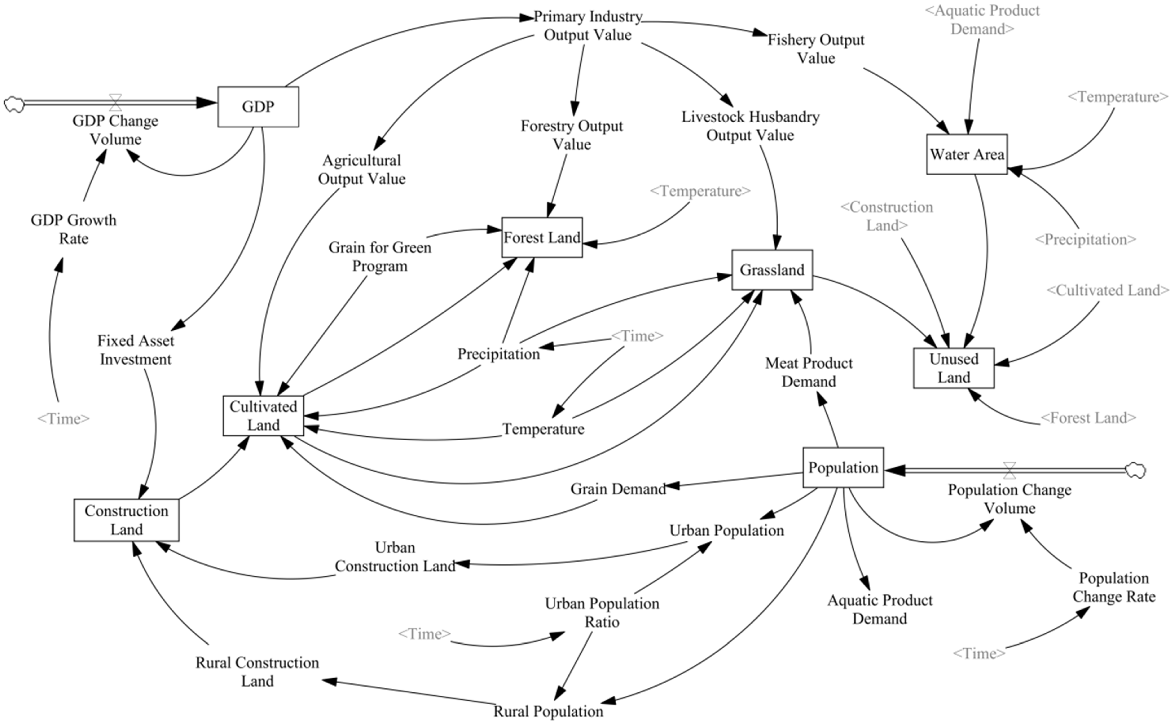
- Model Construction
- 2.
- Model validation
- 3.
- Parameter settings for multiple land-use scenarios
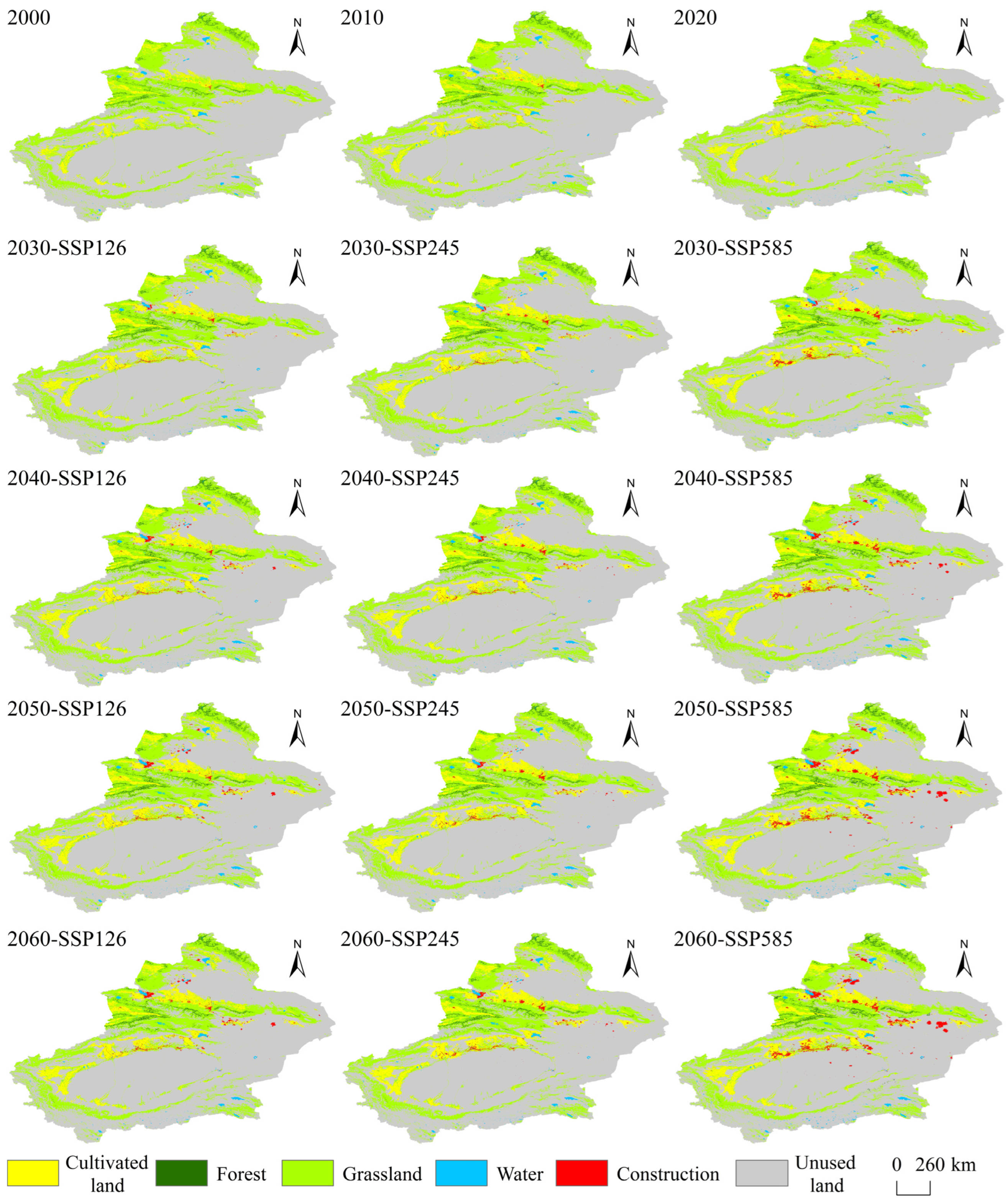
2.3.2. Spatial Prediction of Land Use
- LEAS Module
- 2.
- CARS Module
- 3.
- Accuracy Validation
2.3.3. Calculation of Carbon Emissions
- Direct Carbon Emission Calculation
- 2.
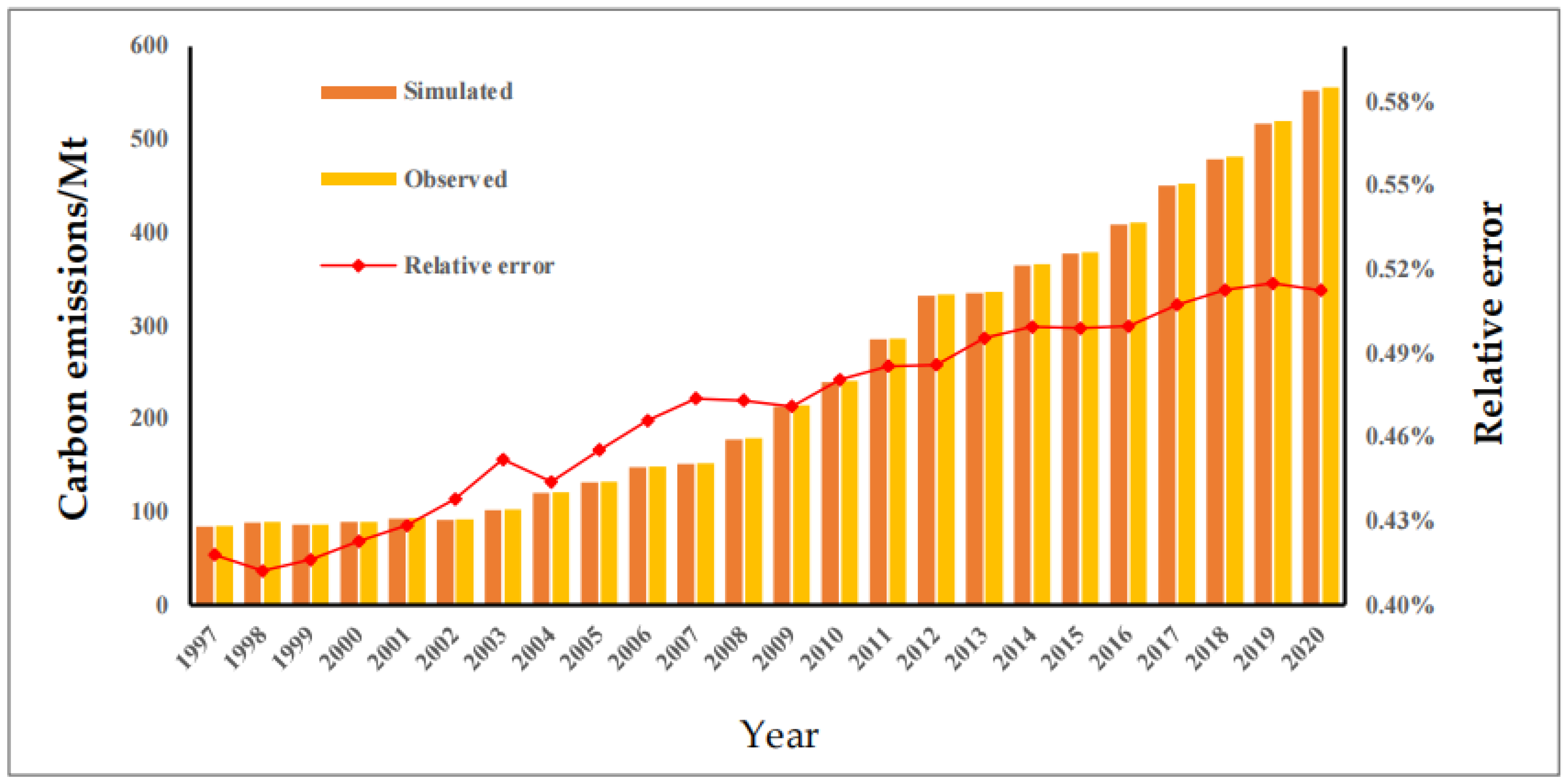
- Indirect Carbon Emissions Calculations for 2000–2020
- 3.
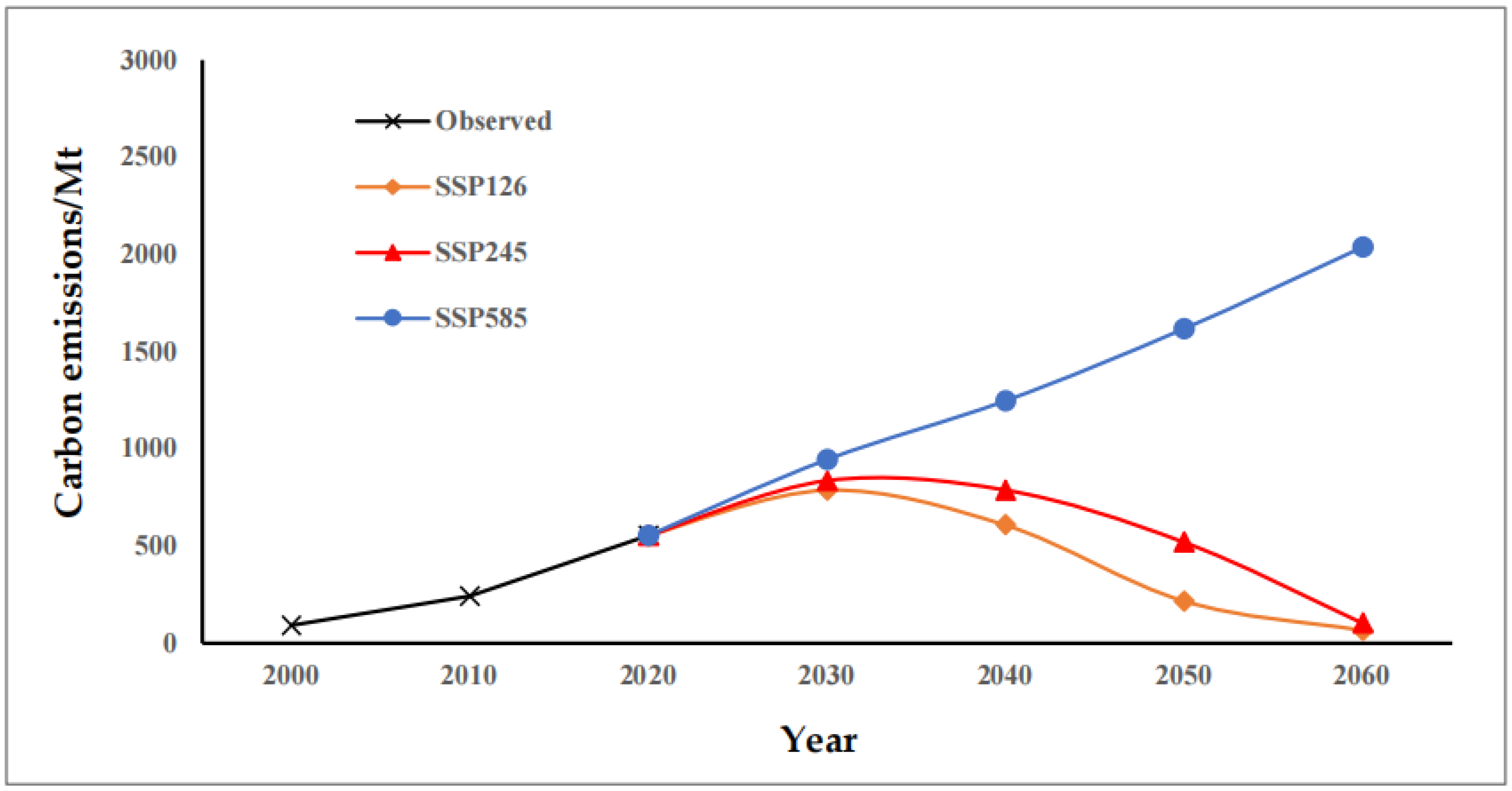
- Projection of Future Indirect Carbon Emissions
2.3.4. Carbon Storage Estimation
2.3.5. Calculation of CESR
3. Results
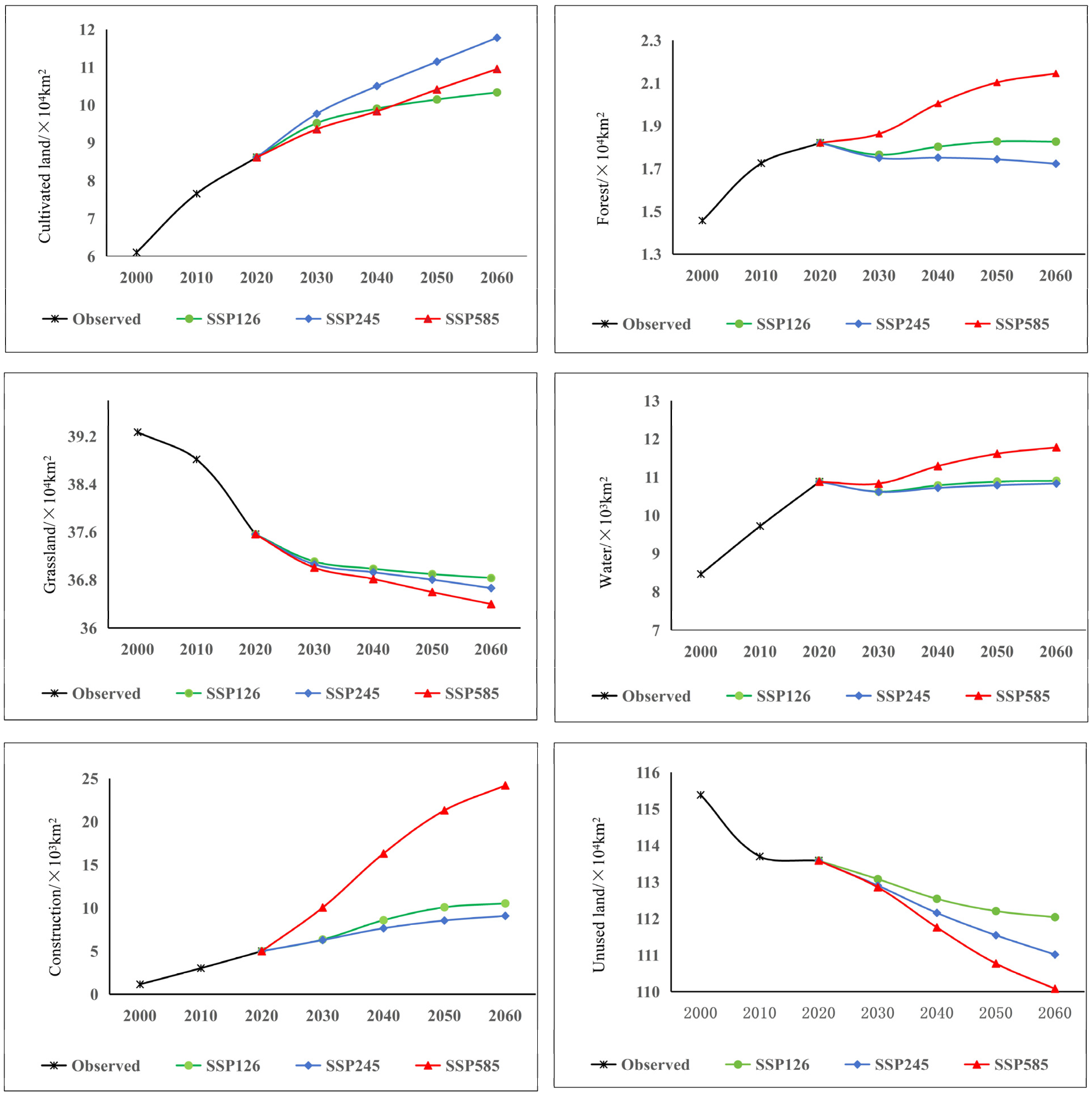
3.1. Spatiotemporal Evolution of Land Use
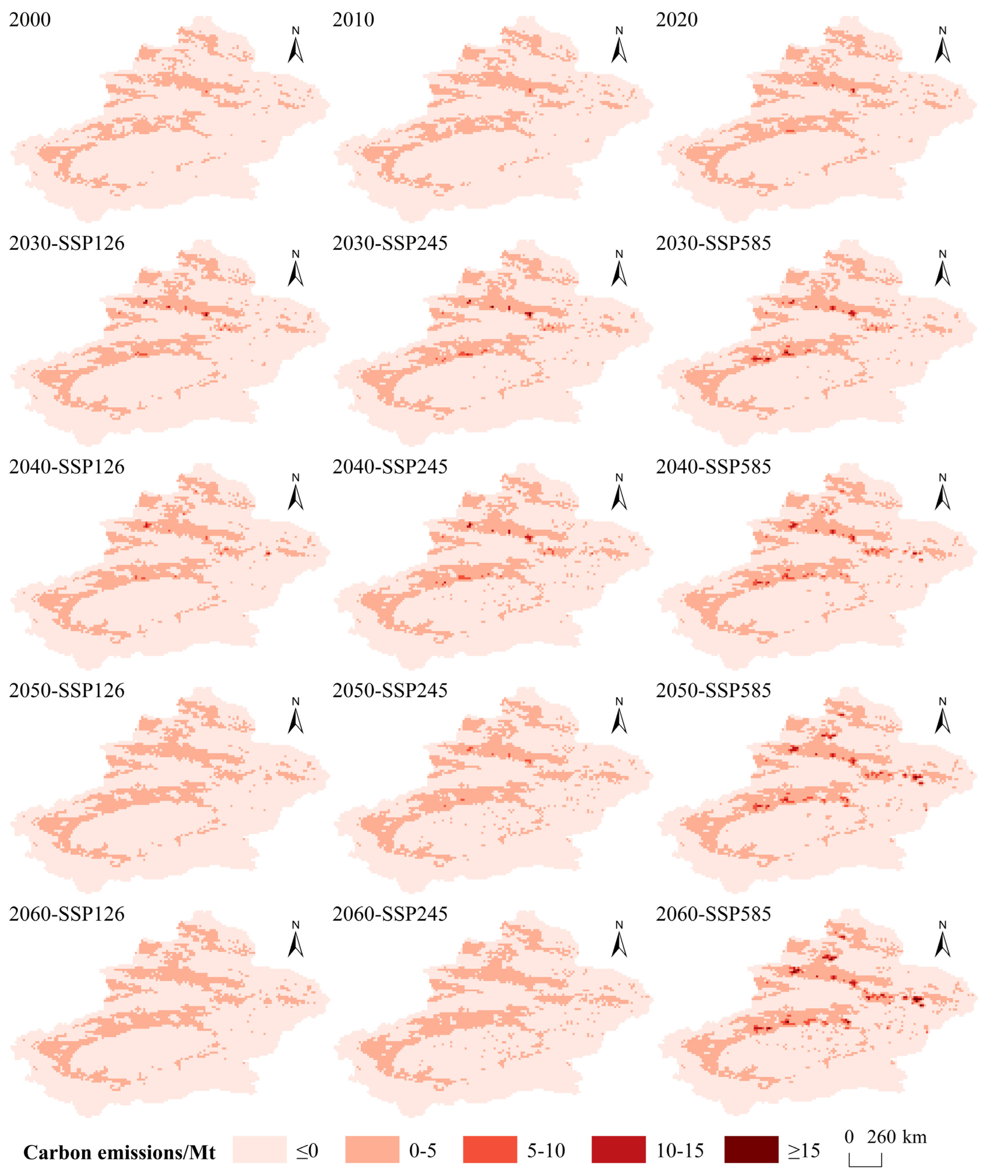
3.2. Spatiotemporal Evolution of Land-Use Carbon Emissions
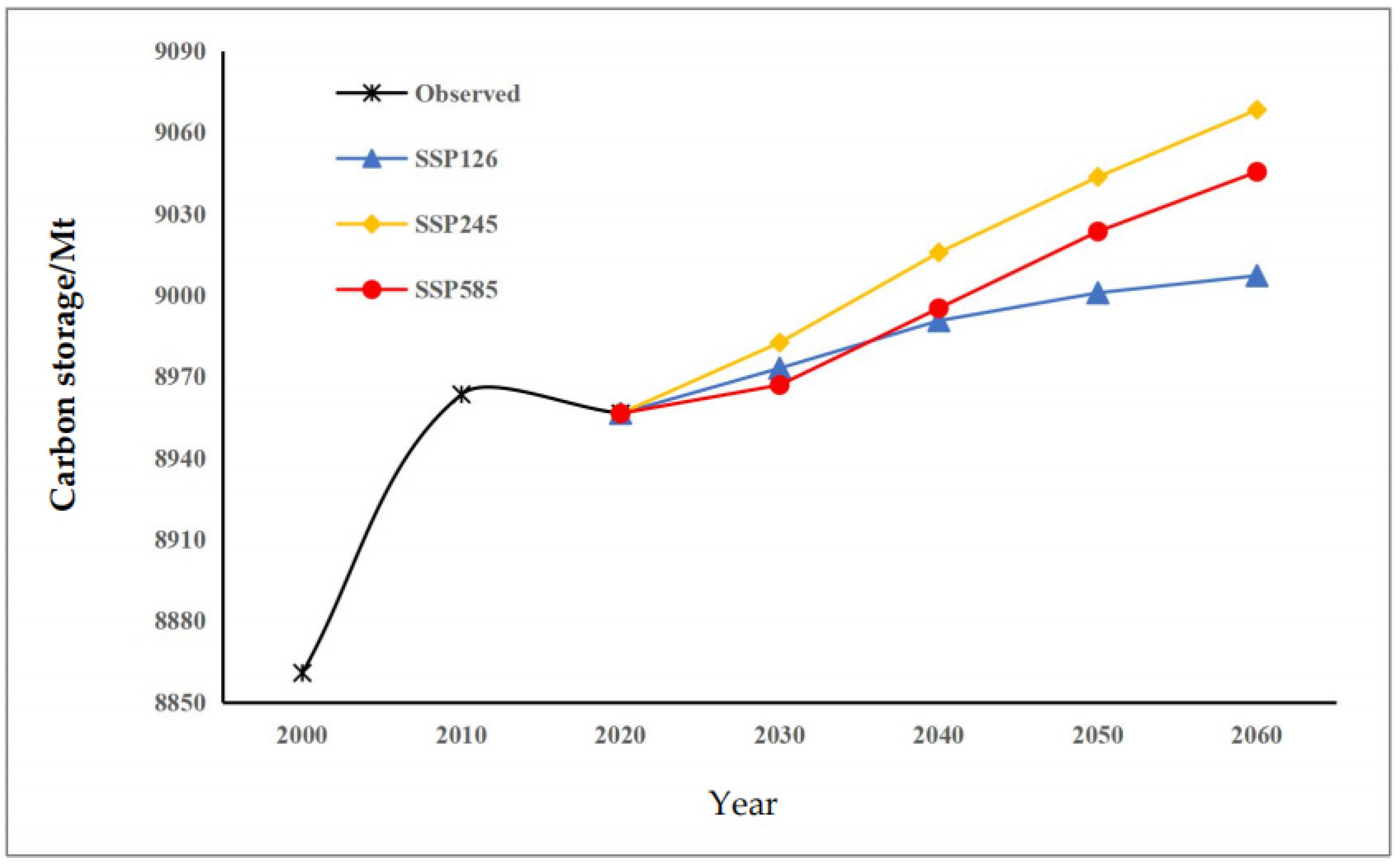
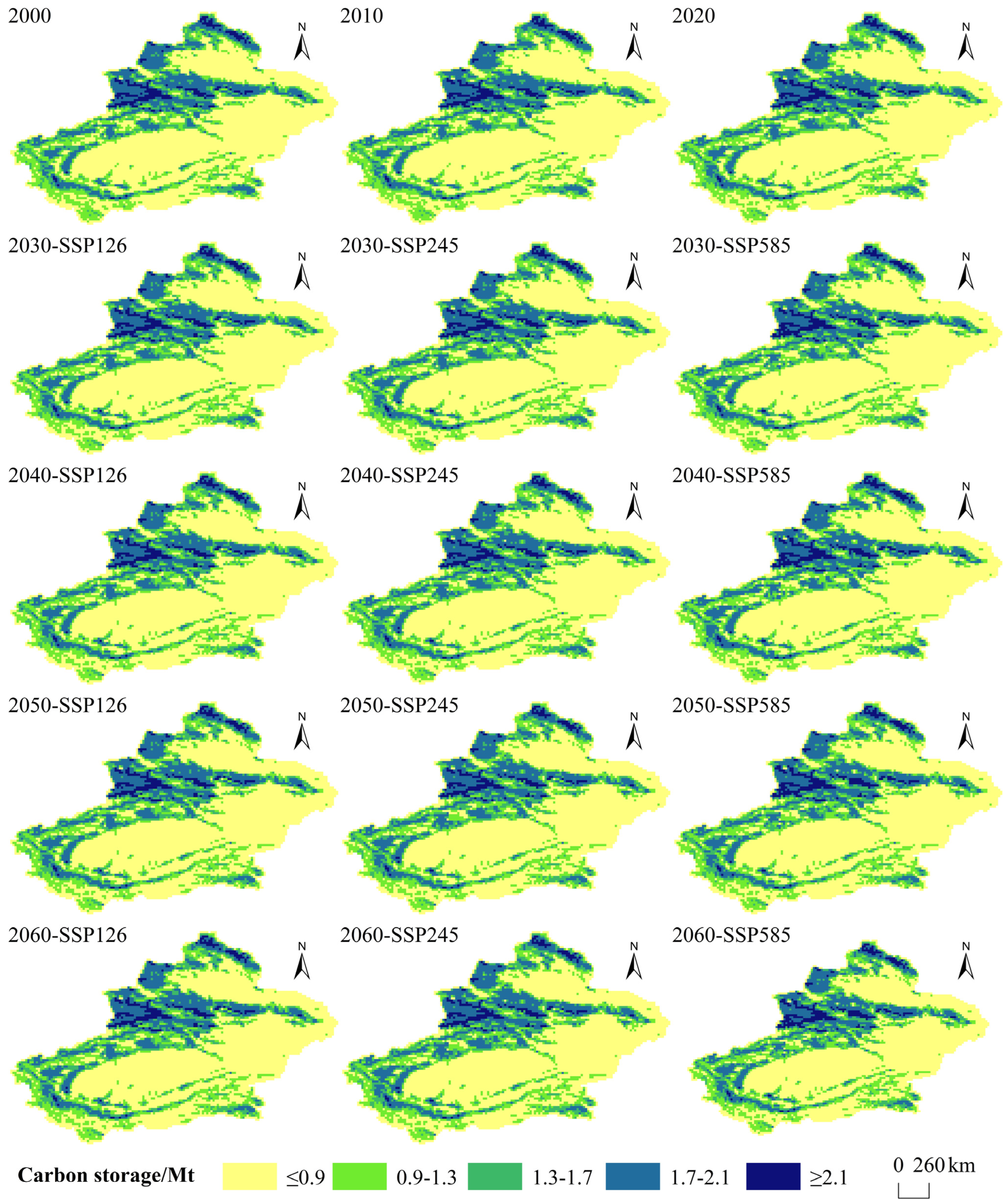
3.3. Spatiotemporal Evolution of Carbon Storage
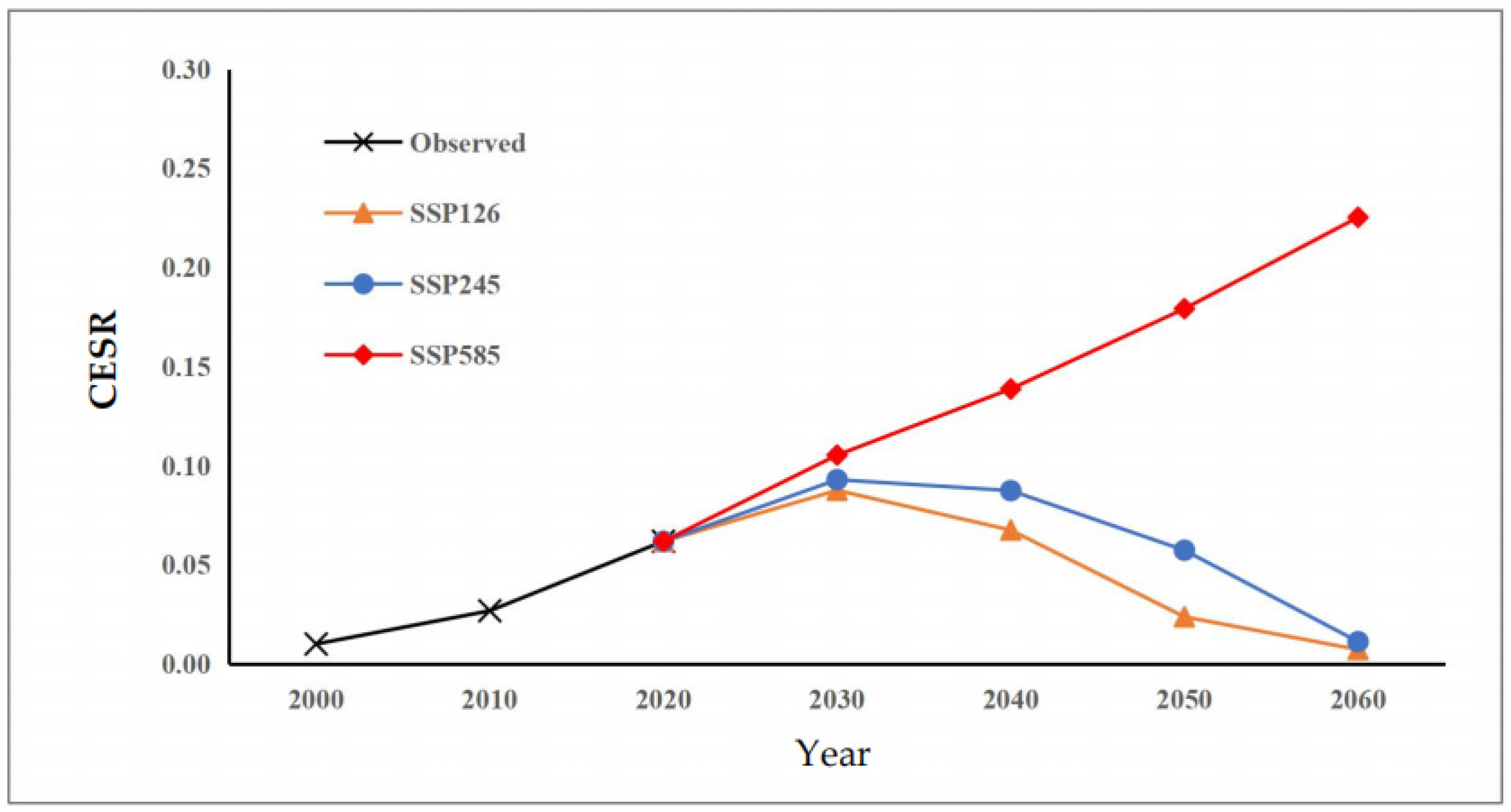
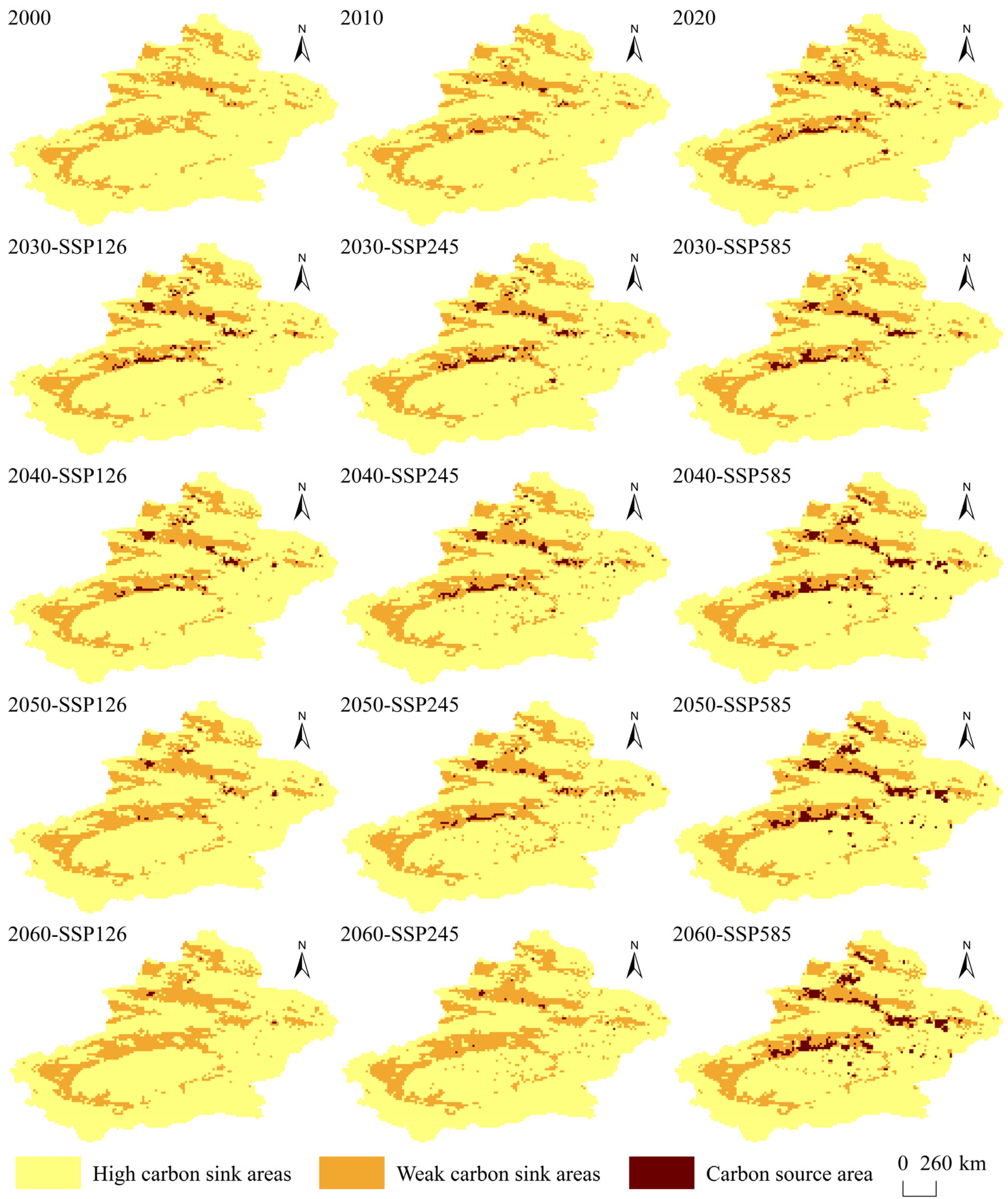
3.4. Spatiotemporal Evolution of CESR
4. Discussion
4.1. Spatiotemporal Variations in Land Use, Carbon Emissions, Carbon Storage, and CESR in Xinjiang
4.2. Countermeasures and Suggestions
4.3. Limitations and Future Perspectives
5. Conclusions
Author Contributions
Funding
Data Availability Statement
Acknowledgments
Conflicts of Interest
Appendix A

| Type | Equations |
|---|---|
| Cultivated land | 650 + e−0.2231 × Agricultural output − 1.05 × Construction + 115.2 × Temperature − 1.3 × Precipitation + 215.6 × Grain demand |
| Forest | 17,850 + e3.912 × Forest output − 15 × Temperature + 10 × Precipitation − 0.05 × Cultivated land |
| Grassland | 380,500 − 150 × Temperature + 80 × Precipitation − e−0.6932 × Animal husbandry output − 0.2 × Cultivated land + 1.2 × Demand for meat products |
| Water | 9050 − 43.8 × Temperature + 3.2 × Precipitation + 5.8 × Demand for Aquatic products + e3.157 × Fishery output |
| Construction | 1850 − 0.18 × Rural construction land + 1.25 × Urban construction land + e−2.1203 × Fixed investment |
| Unused land | 1,631,675 − Cultivated land − Forest − Grassland − Water − Construction − Unused land |
References
- Chen, W.X.; Gu, T.C.; Fang, C.L.; Zeng, J. Global urban low-carbon transitions: Multiscale relationship between urban land and carbon emissions. Environ. Impact Assess. Rev. 2023, 100, 107076. [Google Scholar] [CrossRef] [Scilit]
- Ding, M.L.; Yang, X.N.; Zhao, R.Q.; Zhang, Z.P.; Xiao, L.G.; Xie, Z.X. Optimization of Territorial Spatial Pattern Under the Carbon Neutrality Goal: Theoretical Framework and Practical Strategies. J. Nat. Resour. 2022, 37, 1137–1147. [Google Scholar] [CrossRef] [Scilit]
- Li, D.C.; Lu, J.Q.; Xie, X.W.; Yu, H.; Li, Y.; Wu, S. Optimization of Territorial Spatial Zoning Under the Classification Constraints of Major Function Zones from the Perspective of Carbon Neutrality: A Case Study of Fujian Province. Acta Ecol. Sin. 2022, 42, 10111–10126. [Google Scholar] [CrossRef] [Scilit]
- Yang, G.Q.; Zhu, W.R.; Wen, Y.; Lin, Y.C. Spatial Differentiation in the Intensity and Efficiency of Carbon Emission from Land Use in Guangdong Province in Past Two Decades. Ecol. Environ. Sci. 2019, 28, 332–340. [Google Scholar] [CrossRef]
- Fang, J.Y. Ecological Perspectives of Carbon Neutrality. Chin. J. Plant Ecol. 2021, 45, 1173–1176. [Google Scholar] [CrossRef] [Scilit]
- Baumann, M.; Gasparri, I.; Piquer-Rodríguez, M.; Gavier Pizarro, G.; Griffiths, P.; Hostert, P.; Kuemmerle, T. Carbon emissions from agricultural expansion and intensification in the Chaco. Glob. Change Biol. 2017, 23, 1902–1916. [Google Scholar] [CrossRef] [Scilit]
- Houghton, R.A. Revised Estimates of the Annual Net Flux of Carbon to the Atmosphere from Changes in Land Use and Land Management 1850–2000. Tellus B 2003, 55, 378–390. [Google Scholar] [CrossRef] [Scilit]
- Liu, L.; Qu, J.; Gao, F.; Maraseni, T.N.; Wang, S.; Aryal, S.; Zhang, Z.; Wu, R. Land Use Carbon Emissions or Sink: Research Characteristics, Hotspots and Future Perspectives. Land 2024, 13, 279. [Google Scholar] [CrossRef] [Scilit]
- Friedlingstein, P.; O′SUllivan, M.; Jones, M.W.; Andrew, R.M.; Gregor, L.; Hauck, J.; Le Quéré, C.; Luijkx, I.T.; Olsen, A.; Peters, G.P.; et al. Global Carbon Budget 2022. Earth Syst. Sci. Data 2022, 14, 4811–4900. [Google Scholar] [CrossRef] [Scilit]
- Li, Z.; Zhang, L.; Wang, W.; Ma, W. Assessment of Carbon Emission and Carbon Sink Capacity of China’s Marine Fishery under Carbon Neutrality Target. J. Mar. Sci. Eng. 2022, 10, 1179. [Google Scholar] [CrossRef] [Scilit]
- Wen, H.; Li, Y.; Li, Z.; Cai, X.; Wang, F. Spatial Differentiation of Carbon Budgets and Carbon Balance Zoning in China Based on the Land Use Perspective. Sustainability 2022, 14, 12962. [Google Scholar] [CrossRef] [Scilit]
- Chen, J.Q.; Zhang, K.; Li, X.S.; Shao, Z.H.; Zhai, X.Y. Accounting of Carbon Source/Sink and the Zoning Regulation of Carbon Balance in the Yangtze River Economic Belt: Practicing the Concept of “Prioritizing Ecological Conservation over Excessive Development”. J. Nat. Resour. 2025, 40, 3370–3393. [Google Scholar] [CrossRef] [Scilit]
- Liu, J.M.; Pei, X.T.; Zhu, W.Y.; Jiao, J.Z. Multi-Scenario Simulation of Carbon Budget Balance in Arid and Semi-Arid Regions. J. Environ. Manag. 2023, 346, 119016. [Google Scholar] [CrossRef] [Scilit]
- Li, J.Q.; Zhang, F.Y.; Li, Q.; Teng, L.; Li, D.Q.; Zhou, X.Y. Spatiotemporal Evolution Analysis and Simulation of Carbon Emissions and Carbon Storage from Land Use in Xinjiang Based on the PLUS-InVEST Model. J. Agric. Resour. Environ. 2025, 42, 1636–1647. (In Chinese) [Google Scholar] [CrossRef]
- Yang, Y.P.; Hu, W.M.; Jia, G.Y.; Li, G.; Li, Y. Scenario Simulation of Land Use Carbon Storage in the Surrounding Areas of Dongting Lake Based on InVEST and ANN-CA Models. J. Nanjing For. Univ. (Nat. Sci. Ed.) 2023, 47, 175–184. [Google Scholar] [CrossRef]
- Rani, A.; Gupta, S.K.; Singh, S.K.; Meraj, G.; Kumar, P.; Kanga, S.; Đurin, B.; Dogančić, D. Predicting Future Land Use Utilizing Economic and Land Surface Parameters with ANN and Markov Chain Models. Earth 2023, 4, 728–751. [Google Scholar] [CrossRef] [Scilit]
- Zhang, J.C.; Li, L.; Li, Q.S.; Chen, W.Q.; Huang, J.C.; Guo, Y.L.; Ji, G.X. Multiscenario Land Use Change Simulation and Its Impact on Ecosystem Service Function in Henan Province Based on FLUS-InVEST Model. Ecol. Evol. 2025, 15, e71111. [Google Scholar] [CrossRef] [Scilit] [PubMed]
- Liu, X.P.; Liang, X.; Li, X.; Xu, X.C.; Ou, J.P.; Chen, Y.M.; Li, S.Y.; Wang, S.J.; Pei, F.S. A Future Land Use Simulation Model (FLUS) for Simulating Multiple Land Use Scenarios by Coupling Human and Natural Effects. Landsc. Urban Plan. 2017, 168, 94–116. [Google Scholar] [CrossRef] [Scilit]
- Halmy, M.W.A.; Gessler, P.E.; Hicke, J.A.; Salem, B.B. Land Use/Land Cover Change Detection and Prediction in the North-Western Coastal Desert of Egypt Using Markov-CA. Appl. Geogr. 2015, 63, 101–112. [Google Scholar] [CrossRef] [Scilit]
- Ma, S.L.; Huang, J.L.; Wang, X.X.; Fu, Y. Multi-Scenario Simulation of Low-Carbon Land Use Based on the SD-FLUS Model in Changsha, China. Land Use Policy 2025, 148, 107418. [Google Scholar] [CrossRef] [Scilit]
- Zhang, Z.R.; Li, X.M.; Liu, X.Y. Dynamic Simulation and Projection of Land Use Change Using System Dynamics Model in the Chinese Tianshan Mountainous Region, Central Asia. Sci. Total Environ. 2024, 487, 110564. [Google Scholar] [CrossRef] [Scilit]
- Rong, T.Q.; Qin, M.Z.; Zhang, P.Y.; Chang, Y.H.; Liu, Z.Y.; Zhang, Z.F. Spatiotemporal Evolution of Land Use Carbon Emissions and Multi-Scenario Simulation in the Future—Based on Carbon Emission Fair Model and PLUS Model. Environ. Technol. Innov. 2025, 38, 104087. [Google Scholar] [CrossRef] [Scilit]
- Meng, J.J.; Wang, C.; Zou, Y.; Han, Z.Y.; Zou, G.N. Multi-Scale Spatiotemporal Interactions Between Land Use Transformation and Carbon Emissions in China from 1980 to 2020. Resour. Conserv. Recycl. 2026, 226, 108653. [Google Scholar] [CrossRef] [Scilit]
- Nelson, E.; Sander, H.; Hawthorne, P.; Conte, M.; Ennaanay, D.; Wolny, S.; Manson, S.; Polasky, S. Projecting Global Land-Use Change and Its Effect on Ecosystem Service Provision and Biodiversity with Simple Models. PLoS ONE 2010, 5, e14327. [Google Scholar] [CrossRef] [Scilit]
- Peng, M.; Yang, Y.; Deng, Y.; Jize, D.; Chen, H.; Hai, Y.; Liu, G.; Wang, H.; Xie, T.; Li, H.; et al. The Impact of the Grain-for-Green Programme on Carbon Storage in the Upper Yangtze River Basin Based on the PLUS-InVEST Model. Carbon Balance Manag. 2025, 20, 24. [Google Scholar] [CrossRef] [Scilit] [PubMed]
- Li, Y.; Peng, Y.-L.; Cheng, W.-Y.; Peng, H.-N. Spatial-Temporal Evolution and Multi-Scenario Prediction of Carbon Emissions from Land Use in the Adjacent Areas of Nature Reserves. Ecol. Indic. 2025, 170, 113047. [Google Scholar] [CrossRef] [Scilit]
- Wu, Q.; Wang, L.; Wang, T.Y.; Ruan, Z.Y.; Du, P. Spatial–Temporal Evolution Analysis of Multi-Scenario Land Use and Carbon Storage Based on PLUS-InVEST Model: A Case Study in Dalian, China. Ecol. Indic. 2024, 166, 112448. [Google Scholar] [CrossRef] [Scilit]
- Li, D.Q.; Zhang, F.Y.; Li, Q.; Zhou, H.T.; Li, J.Q.; Zhou, X.Y. Spatiotemporal Evolution and Prediction of Carbon Storage in the Bosten Lake Basin Based on the PLUS-InVEST Model. J. Agric. Resour. Environ. 2025, 42, 1267–1276. (In Chinese) [Google Scholar] [CrossRef]
- Jiang, H.; Cui, Z.; Fan, T.; Yin, H. Impacts of Land Use Change on Carbon Storage in the Guangxi Beibu Gulf Economic Zone Based on the PLUS-InVEST Model. Sci. Rep. 2025, 15, 6468. [Google Scholar] [CrossRef] [Scilit]
- Yang, J.; Huang, X. The 30 m Annual Land Cover Dataset and Its Dynamics in China from 1990 to 2019. Earth Syst. Sci. Data 2021, 13, 3907–3925. [Google Scholar] [CrossRef] [Scilit]
- Chen, Y.D.; Guo, F.; Wang, J.C.; Cai, W.J.; Wang, C.; Wang, K.C. Provincial and Gridded Population Projection for China under Shared Socioeconomic Pathways from 2010 to 2100. Sci. Data 2020, 7, 83. [Google Scholar] [CrossRef] [Scilit]
- Murakami, D.; Yoshida, T.; Yamagata, Y. Gridded GDP Projections Compatible with the Five SSPs (Shared Socioeconomic Pathways). Front. Built Environ. 2021, 7, 760306. [Google Scholar] [CrossRef] [Scilit]
- Xing, X.T.; Wang, Q.; Meng, F.; Liu, P.D.; Huang, L.; Zhuo, W. Assessing the Land Use-Carbon Storage Nexus Along G318: A Coupled SD-PLUS-InVEST Model Approach for Spatiotemporal Coordination Optimization. Land 2025, 14, 2067. [Google Scholar] [CrossRef] [Scilit]
- Li, Y.; Wang, C.D.; Sun, M.X.; Zhang, H. Dynamic Simulation of Land Use Change and Assessment of Ecosystem Services Under Climate Change Scenarios: A Case Study of Shanghai, China. Land 2025, 14, 1791. [Google Scholar] [CrossRef] [Scilit]
- Wang, Z.Y.; Li, X.; Mao, Y.T.; Li, L.; Wang, X.R.; Lin, Q. Dynamic Simulation of Land Use Change and Assessment of Carbon Storage Based on Climate Change Scenarios at the City Level: A Case Study of Bortala, China. Ecol. Indic. 2022, 134, 108499. [Google Scholar] [CrossRef] [Scilit]
- Cui, Y.Y.; Wu, C.B.; Niu, G.; Huang, G.H. Water Yield Service Flow Assessment Under Future SSP-RCP Scenarios in the Yellow River Basin: Coupled Effect of Climate and Land Use Change. J. Hydrol. 2025, 662, 133852. [Google Scholar] [CrossRef] [Scilit]
- Liang, X.; Guan, Q.F.; Clarke, K.C.; Liu, S.S.; Wang, B.Y.; Yao, Y. Understanding the Drivers of Sustainable Land Expansion Using a Patch-Generating Land Use Simulation (PLUS) Model: A Case Study in Wuhan, China. Comput. Environ. Urban Syst. 2021, 85, 101569. [Google Scholar] [CrossRef] [Scilit]
- Dietz, T.; Rosa, E.A. Effects of Population and Affluence on CO2 Emissions. Proc. Natl. Acad. Sci. USA 1997, 94, 175–179. [Google Scholar] [CrossRef] [Scilit]
- Hou, Y.F.; Chen, Y.N.; Li, Z.; Li, Y.P.; Sun, F. Land Structure Change and Ecological Effects Under Future Development Scenarios in Tarim River Basin, Central Asia. Geogr. Sustain. 2025, 6, 100300. [Google Scholar] [CrossRef] [Scilit]
- Ye, Y.; Lai, M.; Dong, M.; Li, Z.; Yuan, J.; Lyu, J. Coupling the PLUS-InVEST Model for Multi-Scenario Land Use Simulation and Carbon Storage Assessment in Northern Anhui, China. Sustainability 2025, 17, 4185. [Google Scholar] [CrossRef] [Scilit]
- Jing, J.; Wei, F.; Jiang, H.; Chen, Z.; Lv, S.; Li, T.; Li, W.; Tang, Y. Prediction of Land Use Change and Carbon Storage in Lijiang River Basin Based on InVEST-PLUS Model and SSP-RCP Scenario. Land 2025, 14, 460. [Google Scholar] [CrossRef] [Scilit]
- Alam, S.A.; Starr, M.; Clark, B.J.F. Tree Biomass and Soil Organic Carbon Densities across the Sudanese Woodland Savannah: A Regional Carbon Sequestration Study. J. Arid. Environ. 2013, 89, 67–76. [Google Scholar] [CrossRef] [Scilit]
- Giardina, C.P.; Ryan, M.G. Evidence that decomposition rates of organic carbon in mineral soil do not vary with temperature. Nature 2000, 404, 858–861. [Google Scholar] [CrossRef] [Scilit]
- Zhu, G.F.; Qiu, D.; Zhang, Z.; Sang, L.; Liu, Y.; Wang, L.; Zhao, K.; Ma, H.; Xu, Y.; Wan, Q. Land-Use Changes Lead to a Decrease in Carbon Storage in Arid Region, China. Ecol. Indic. 2021, 127, 107770. [Google Scholar] [CrossRef] [Scilit]




| Type | Data | Resolution | Source | |
|---|---|---|---|---|
| Land-use data | Land-use remote sensing data for the years 2000, 2010, and 2011–2020 | 30 m × 30 m | China Annual Land Cover Dataset [30] | |
| Carbon emission data | Indirect carbon emission data for Xinjiang, 1997–2020 | — | China Carbon Emissions Database (https://www.ceads.net.cn, accessed on 20 January 2026) | |
| Socio-economic and climate data | Data on temperature, precipitation, GDP, etc., in Xinjiang from 2011 to 2020 | — | Xinjiang Statistical Yearbook | |
| SSP-RCP data for 2021–2060 | Temperature, precipitation | — | CMIP6 climate dataset (https://pcmdi.llnl.gov/CMIP6/, accessed on 20 January 2026.) | |
| GDP | — | SSP1–5 Global 1/12° Gridded GDP Forecast Data [32] | ||
| Population | — | China Population Grid Data at Kilometre Scale [31] | ||
| Driver factor data | Physical geographical factors | DEM | 30 m × 30 m | Geospatial Data Cloud (http://www.gscloud.cn, accessed on 20 January 2026.) |
| Grade and aspect | 30 m × 30 m | ArcGIS 10.8 software performs spatial analysis on DEMs to obtain | ||
| Annual average precipitation and annual average temperature for 2018 | 30 m × 30 m | Centre for Resource and Environmental Science and Data, Chinese Academy of Sciences (https://www.resdc.cn/Default.aspx, accessed on 20 January 2026.) | ||
| Socio-economic factors | Population and GDP in 2018 | 1 km × 1 km | Centre for Resource and Environmental Science and Data, Chinese Academy of Sciences (https://www.resdc.cn/Default.aspx, accessed on 20 January 2026.) | |
| Transport factors | Distance to railway station, distance to motorway junction, distance to city arterial road, distance to national highway | — | ArcGIS software performed Euclidean distance analysis on road data to obtain | |
| Variable | 2020–2030 | 2030–2040 | 2040–2050 | 2050–2060 | ||||||||
|---|---|---|---|---|---|---|---|---|---|---|---|---|
| SSP126 | SSP245 | SSP585 | SSP126 | SSP245 | SSP585 | SSP126 | SSP245 | SSP585 | SSP126 | SSP245 | SSP585 | |
| Population growth rate/% | 0.91 | 1.09 | 1.12 | 0.62 | 0.81 | 1.09 | 0.35 | 0.64 | 0.93 | 0.2 | 0.57 | 0.64 |
| GDP growth rate/% | 8.57 | 6.28 | 10.78 | 4.81 | 2.82 | 6.06 | 2.12 | 1.56 | 2.9 | 0.42 | 0.74 | 1.3 |
| Annual mean temperature/°C | 7.96 | 8.13 | 8.41 | 7.77 | 7.96 | 8.44 | 7.97 | 8.42 | 9.37 | 8.09 | 8.74 | 10.1 |
| Annual average precipitation/mm | 144.92 | 144.89 | 144.53 | 148.12 | 152.58 | 157.8 | 149.24 | 157.07 | 166.5 | 147.56 | 156.82 | 167.67 |
| Type | 2012 | 2014 | 2016 | 2018 | 2020 | |
|---|---|---|---|---|---|---|
| Cultivated Land | Observed value | 81,431 | 84,882 | 86,756 | 85,946 | 86,164 |
| Simulated value | 78,970 | 81,173 | 84,560 | 87,121 | 89,130 | |
| Relative error (%) | 0.45 | 4.37 | 2.53 | 1.37 | 3.44 | |
| Forest | Observed value | 17,337 | 17,702 | 17,945 | 18,145 | 18,199 |
| Simulated value | 17,991 | 17,754 | 18,312 | 17,772 | 18,023 | |
| Relative error (%) | 3.78 | 0.3 | 2.05 | 2.05 | 0.96 | |
| Grassland | Observed value | 382,494 | 380,973 | 380,411 | 378,547 | 375,606 |
| Simulated value | 376,327 | 374,413 | 379,438 | 374,884 | 377,092 | |
| Relative error (%) | 1.61 | 1.72 | 0.26 | 0.97 | 0.40 | |
| Water | Observed value | 9936 | 9958 | 10,410 | 11,052 | 10,857 |
| Simulated value | 10,397 | 10,352 | 10,553 | 10,463 | 10,619 | |
| Relative error (%) | 4.65 | 3.96 | 1.38 | 5.33 | 2.35 | |
| Construction | Observed value | 3393 | 3796 | 4112 | 4505 | 4990 |
| Simulated value | 3389 | 3710 | 3932 | 4461 | 4709 | |
| Relative error (%) | 0.09 | 2.26 | 4.35 | 0.96 | 5.63 | |
| Unused Land | Observed value | 1,137,084 | 1,134,364 | 1,132,041 | 1,133,480 | 1,135,841 |
| Simulated value | 1,144,598 | 1,144,271 | 1,134,877 | 1,136,972 | 1,132,100 | |
| Relative error (%) | 0.66 | 0.87 | 0.25 | 0.31 | 0.33 |
| Type | SSP126 | SSP245 | SSP585 | ||||||||||
|---|---|---|---|---|---|---|---|---|---|---|---|---|---|
| 2030 | 2040 | 2050 | 2060 | 2030 | 2040 | 2050 | 2060 | 2030 | 2040 | 2050 | 2060 | ||
| Cultivated land | Area | 95,213.45 | 99,042.45 | 101,445.65 | 103,331.65 | 97,684.6 | 104,999.5 | 111,446.5 | 117,781 | 93,594.1 | 98,328.7 | 104,090.5 | 109,522.5 |
| Absolute change | 9049.45 | 3829 | 2403.2 | 1886 | 11,520.6 | 7314.9 | 6447 | 6334.5 | 7430.1 | 4734.6 | 5761.8 | 5432 | |
| Percentage change | 10.5 | 4.02 | 2.43 | 1.86 | 13.37 | 7.49 | 6.14 | 5.68 | 8.62 | 5.06 | 5.86 | 5.22 | |
| Forest | Area | 17,646.85 | 18,022.95 | 18,270.15 | 18,260.55 | 17,498.1 | 17,513.2 | 17,431.8 | 17,224.4 | 18,624 | 20,038.8 | 21,025.9 | 21,447.5 |
| Absolute change | 176.05 | 376.1 | 247.2 | 9.6 | 700.9 | 15.1 | 81.4 | 207.4 | 425 | 1414.8 | 987.1 | 421.6 | |
| Percentage change | −0.97 | 2.13 | 1.37 | −0.05 | −3.85 | 0.09 | −0.46 | −1.19 | 2.34 | 7.60 | 4.93 | 2.01 | |
| Grassland | Area | 371,058 | 369,846 | 368,953 | 368,291 | 370,572 | 369,259 | 368,031 | 366,616 | 370,039 | 368,138 | 365,957 | 363,947 |
| Absolute change | 4548 | 1212 | 893 | −662 | 5034 | 1313 | 1228 | 1415 | 5567 | 1091 | 2181 | 2010 | |
| Percentage change | −1.21 | −0.33 | −0.24 | −0.18 | −1.34 | −0.35 | −0.33 | −0.38 | −1.48 | −0.51 | −0.59 | −0.55 | |
| Water | Area | 10,619.2 | 10,781.8 | 10,878.4 | 10,899.9 | 10,610.9 | 10,716.1 | 10,785.8 | 10,830.2 | 10,828.6 | 11,287 | 11,608.9 | 11,778.6 |
| Absolute change | 255.8 | 162.6 | 96.6 | 21.5 | 264.1 | 105.2 | 69.7 | 44.4 | 46.4 | 458.4 | 321.9 | 169.7 | |
| Percentage change | −2.35 | 1.53 | 0.9 | 0.2 | −2.43 | 0.99 | 0.65 | 0.41 | −0.43 | 4.23 | 2.85 | 1.46 | |
| Construction | Area | 6341.41 | 8578.79 | 10,076.8 | 10,522.7 | 6279.79 | 7642.27 | 8543.42 | 9076.95 | 10,039 | 16,310.2 | 21,296.1 | 24,193.6 |
| Absolute change | 1351.41 | 2237.38 | 1498.01 | 445.9 | 1289.79 | 1362.48 | 901.15 | 533.53 | 5049 | 6271.2 | 4985.9 | 2897.5 | |
| Percentage change | 27.08 | 35.28 | 17.46 | 4.43 | 25.85 | 21.7 | 11.79 | 6.24 | 101.18 | 62.47 | 30.57 | 13.61 | |
| Unused land | Area | 1,130,796.09 | 1,125,403.01 | 1,122,051 | 1,120,369.2 | 1,129,029.61 | 1,121,544.93 | 1,115,436.48 | 1,110,146.45 | 1,128,550.3 | 1,117,572.3 | 1,107,696.6 | 1,100,785.8 |
| Absolute change | 5044.91 | 5393.08 | 3352.01 | 1681.8 | 6811.39 | 7484.68 | 6108.45 | 5290.03 | 7290.7 | 10,978 | 9875.7 | 6910.8 | |
| Percentage change | −0.44 | −0.48 | −0.3 | −0.15 | −0.6 | −0.66 | −0.54 | −0.47 | −0.64 | −0.97 | −0.88 | −0.62 | |
Disclaimer/Publisher’s Note: The statements, opinions and data contained in all publications are solely those of the individual author(s) and contributor(s) and not of MDPI and/or the editor(s). MDPI and/or the editor(s) disclaim responsibility for any injury to people or property resulting from any ideas, methods, instructions or products referred to in the content. |
© 2026 by the authors. Licensee MDPI, Basel, Switzerland. This article is an open access article distributed under the terms and conditions of the Creative Commons Attribution (CC BY) license.
Share and Cite
Li, J.; Zhang, F.; Ma, A.; Ma, J.; Li, D.; Li, Q. Spatiotemporal Dynamics and Multi-Scenario Simulations of Land-Use Carbon Emissions and Carbon Storage in Xinjiang Under SSP-RCP Scenarios Using the SD-PLUS-InVEST Model. Land 2026, 15, 756. https://doi.org/10.3390/land15050756
Li J, Zhang F, Ma A, Ma J, Li D, Li Q. Spatiotemporal Dynamics and Multi-Scenario Simulations of Land-Use Carbon Emissions and Carbon Storage in Xinjiang Under SSP-RCP Scenarios Using the SD-PLUS-InVEST Model. Land. 2026; 15(5):756. https://doi.org/10.3390/land15050756
Chicago/Turabian StyleLi, Jianqiang, Feiyun Zhang, Ao Ma, Jingjing Ma, Daqiang Li, and Qian Li. 2026. "Spatiotemporal Dynamics and Multi-Scenario Simulations of Land-Use Carbon Emissions and Carbon Storage in Xinjiang Under SSP-RCP Scenarios Using the SD-PLUS-InVEST Model" Land 15, no. 5: 756. https://doi.org/10.3390/land15050756
APA StyleLi, J., Zhang, F., Ma, A., Ma, J., Li, D., & Li, Q. (2026). Spatiotemporal Dynamics and Multi-Scenario Simulations of Land-Use Carbon Emissions and Carbon Storage in Xinjiang Under SSP-RCP Scenarios Using the SD-PLUS-InVEST Model. Land, 15(5), 756. https://doi.org/10.3390/land15050756