Dasymetric Mapping for People-Centered Wildfire Risk Assessment Case Study: Northern Portugal





Abstract
1. Introduction
2. Materials and Methods
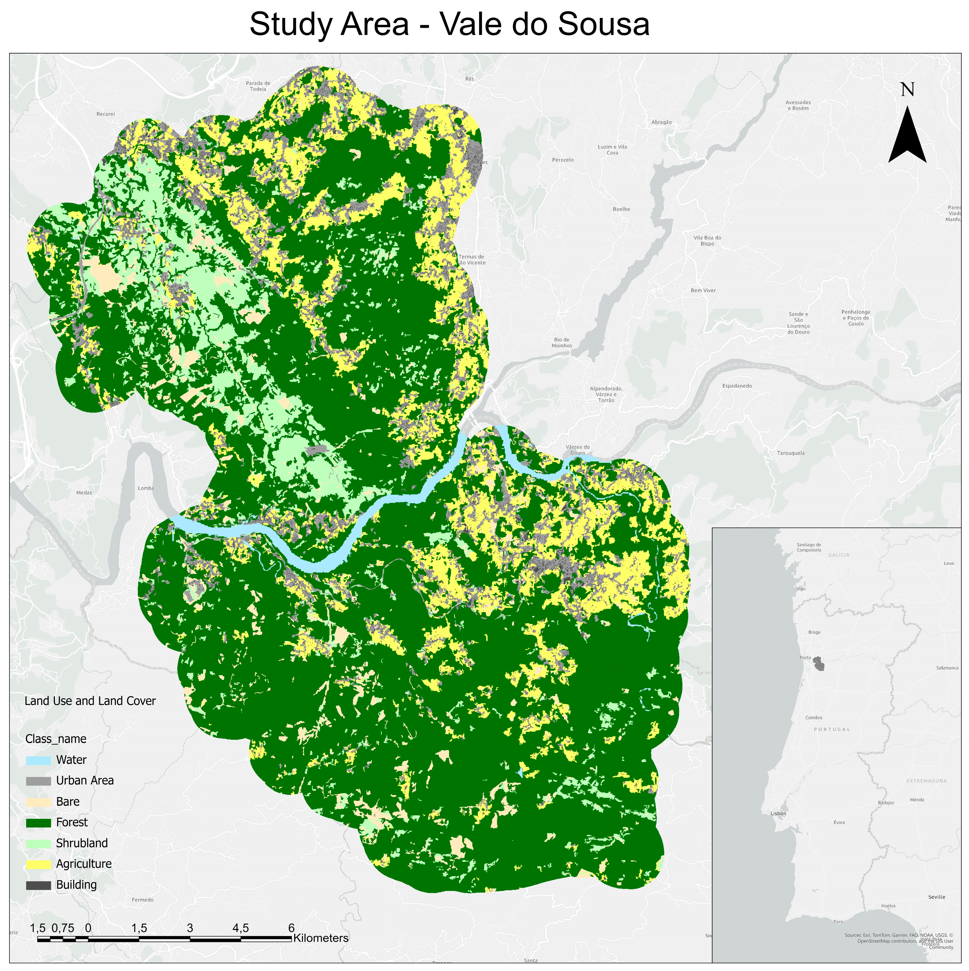
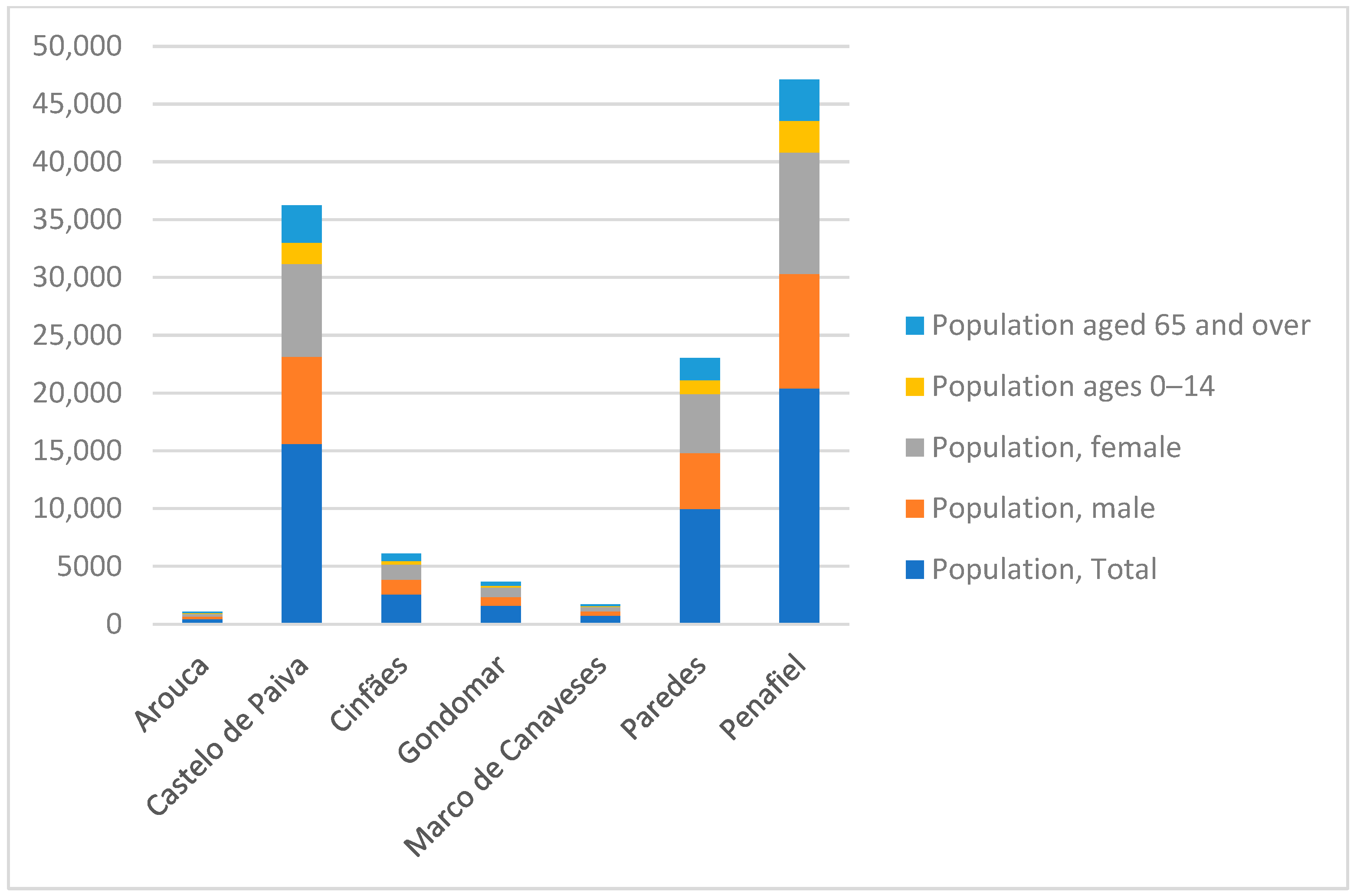
2.1. Remote Sensing Datasets and Demography Information
2.2. WUI Deliniation
- The distance from U to V is equal to the distance from U to W;
- The distance from V to W is equal to the distance from U to W;
- The sum of the distances U-V and V-W is less than the distance U-W multiplied by a tolerance factor T (usually 1.05).
2.3. Dasymetric Mapping
2.4. Population Exposure
3. Results
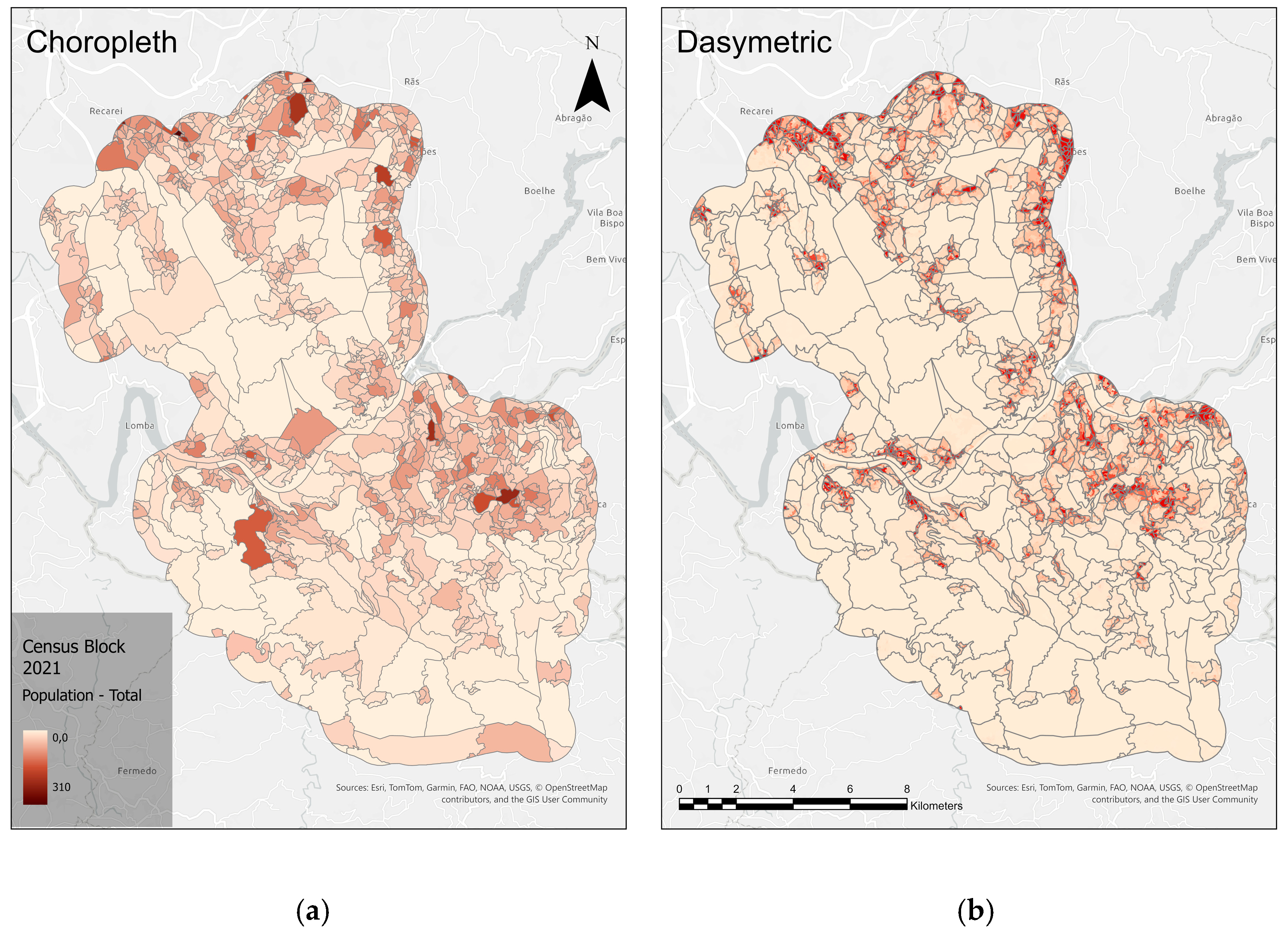
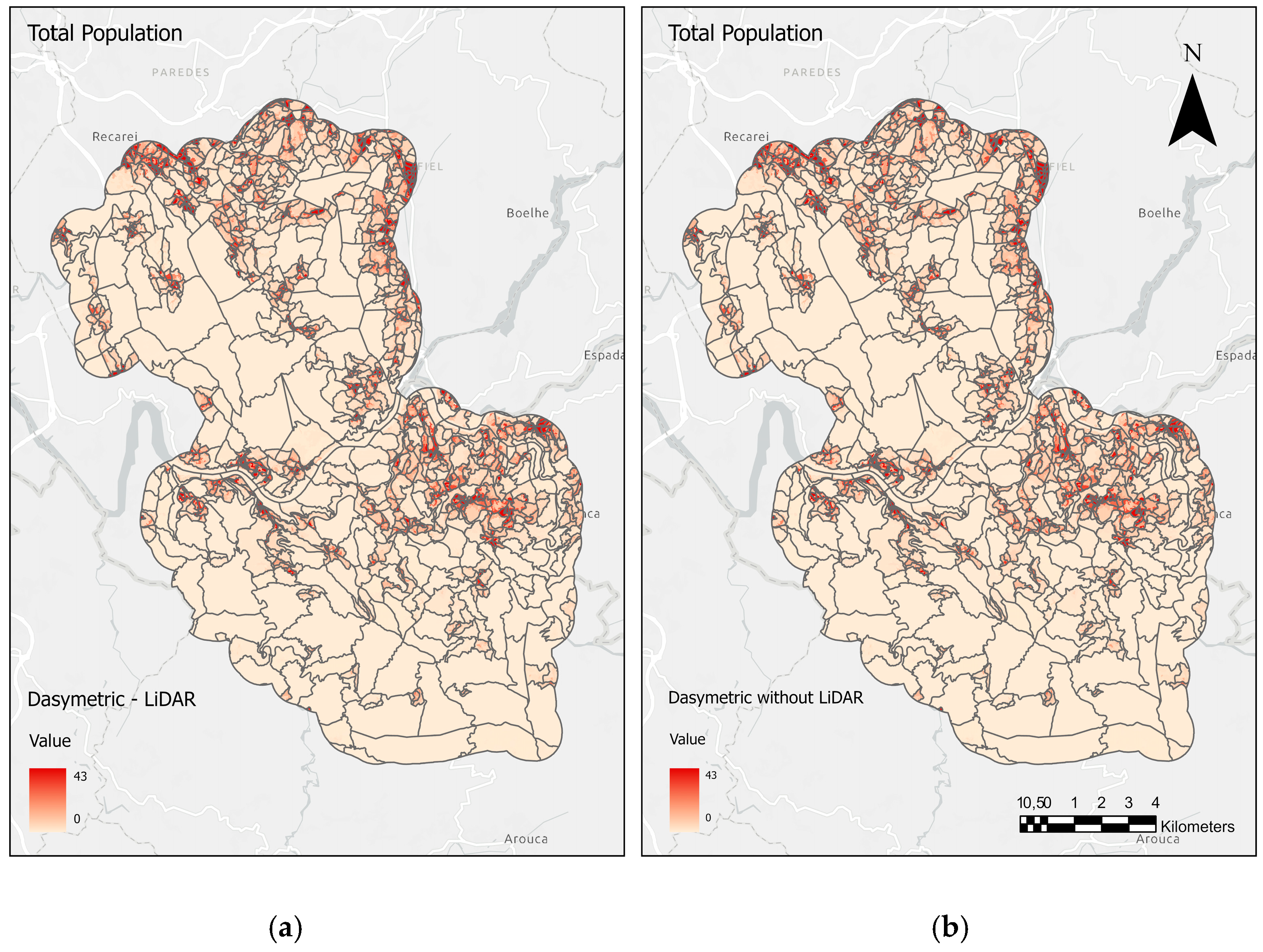
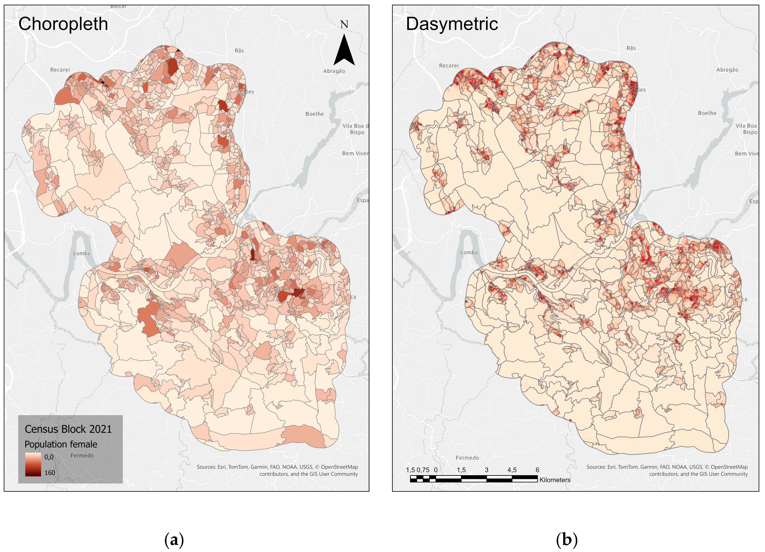
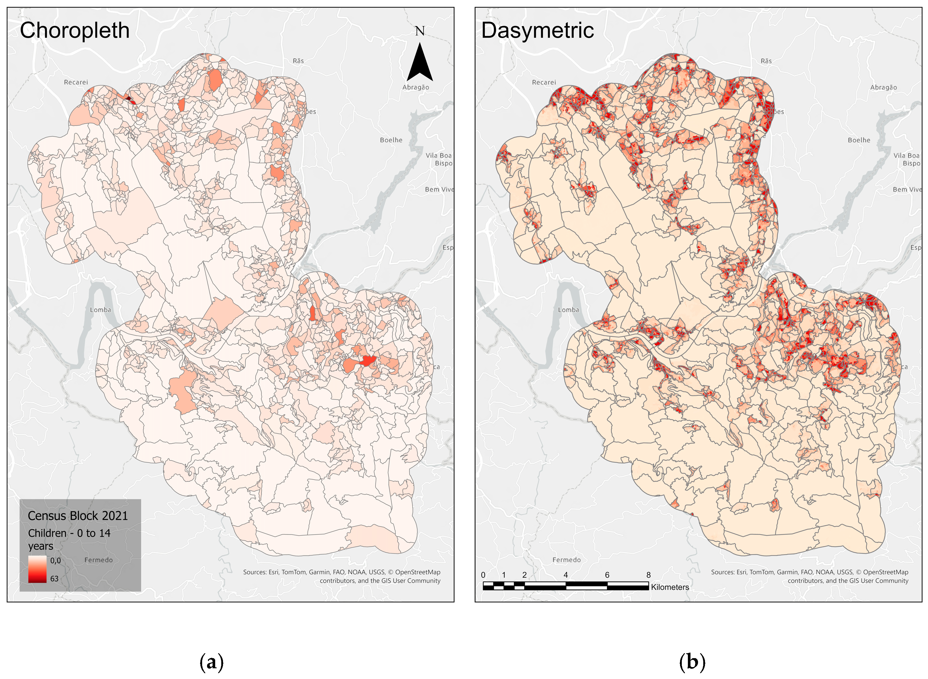
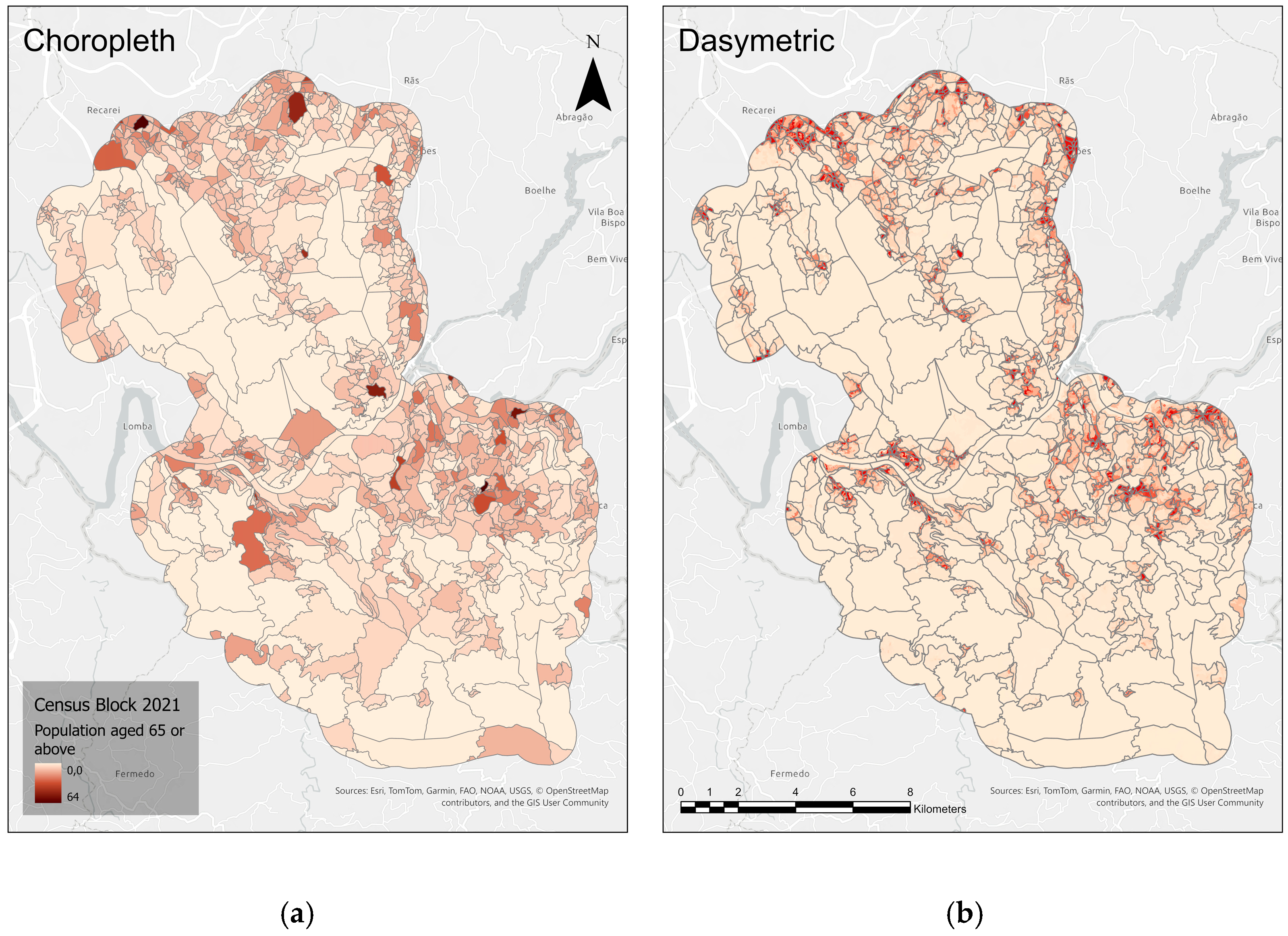
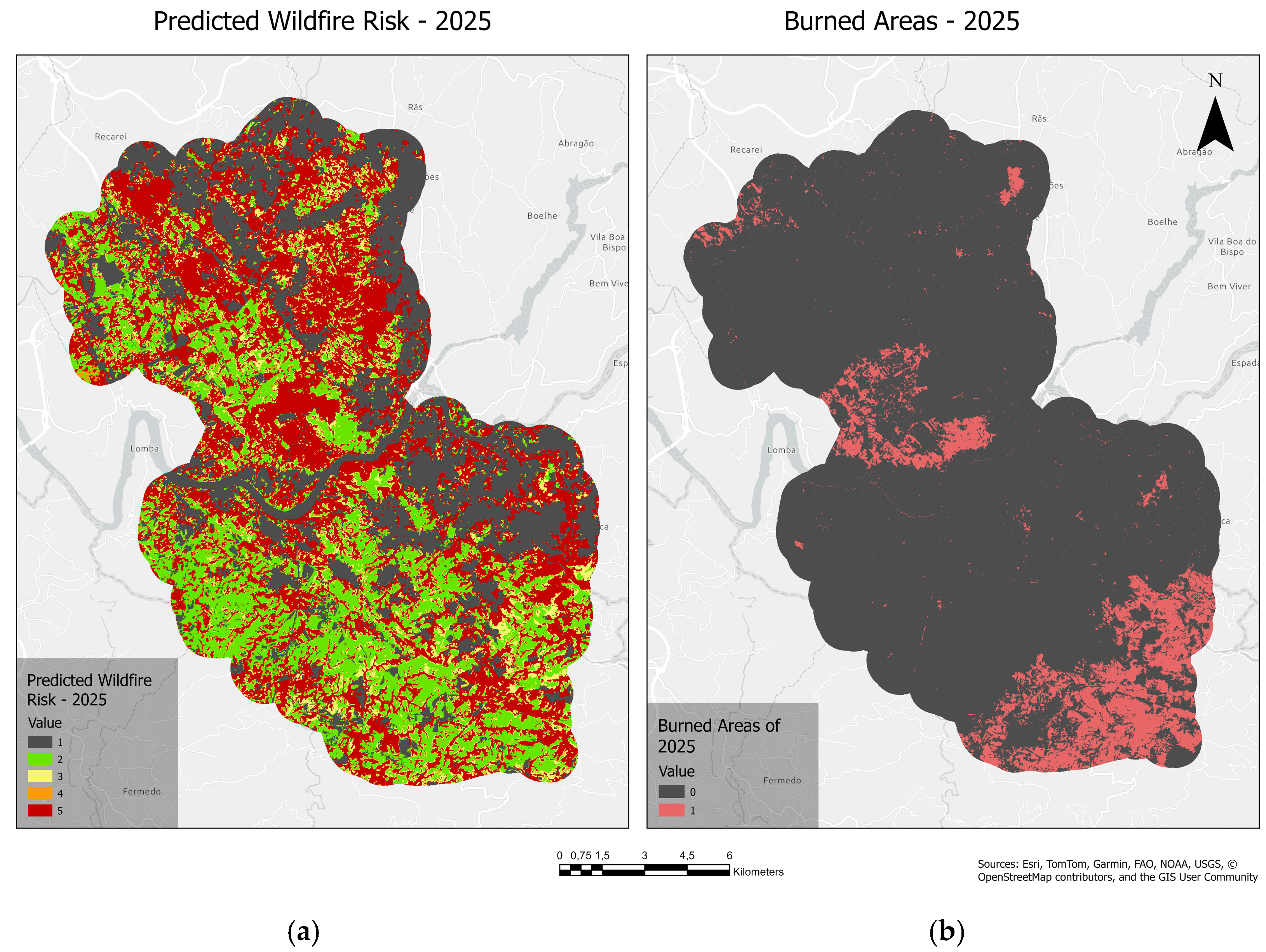
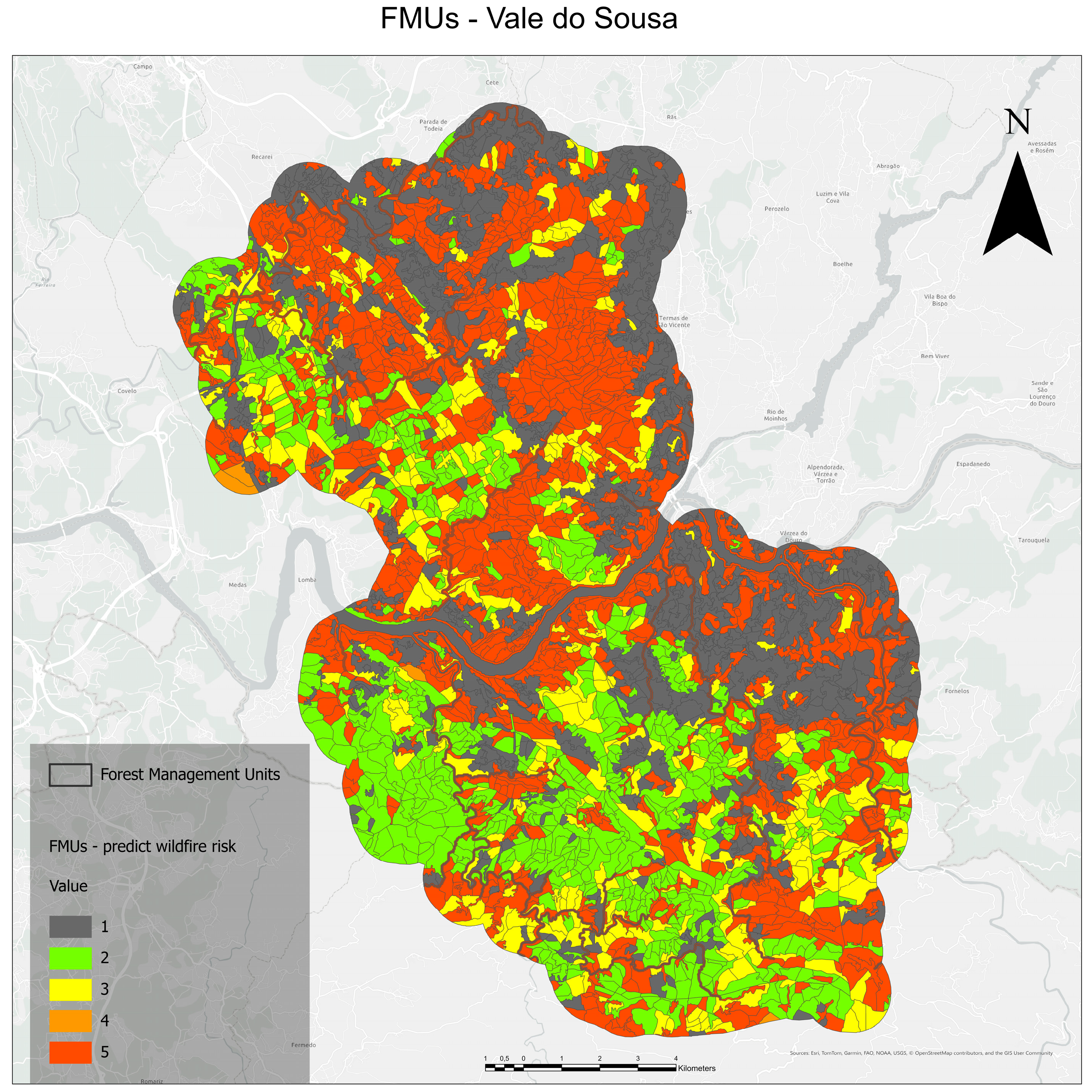
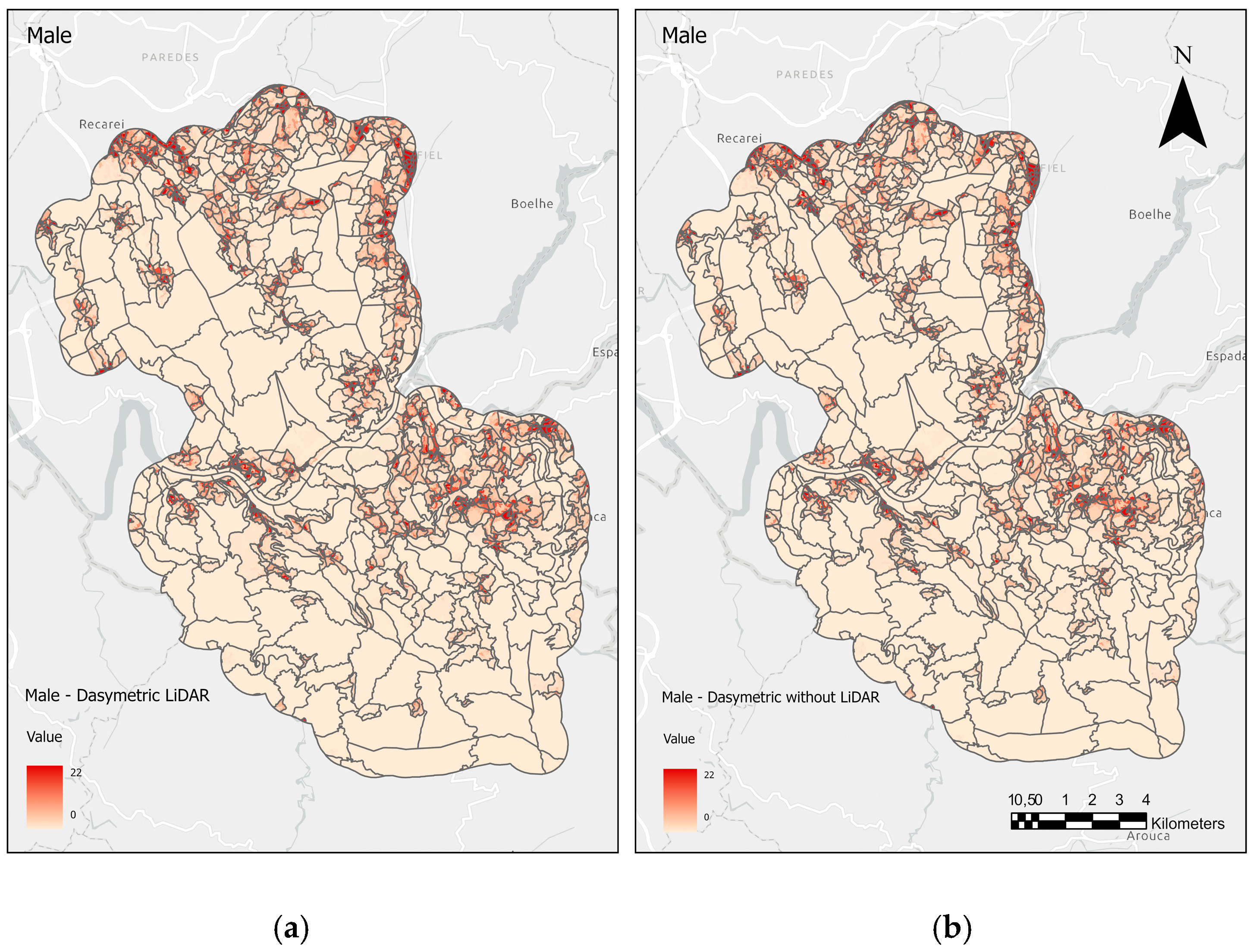
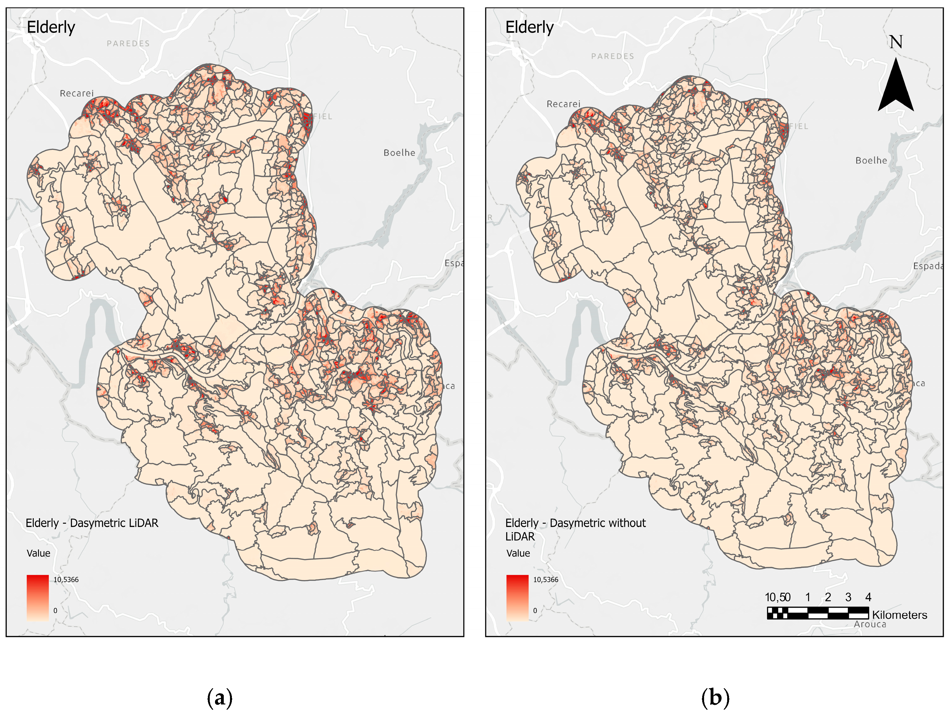
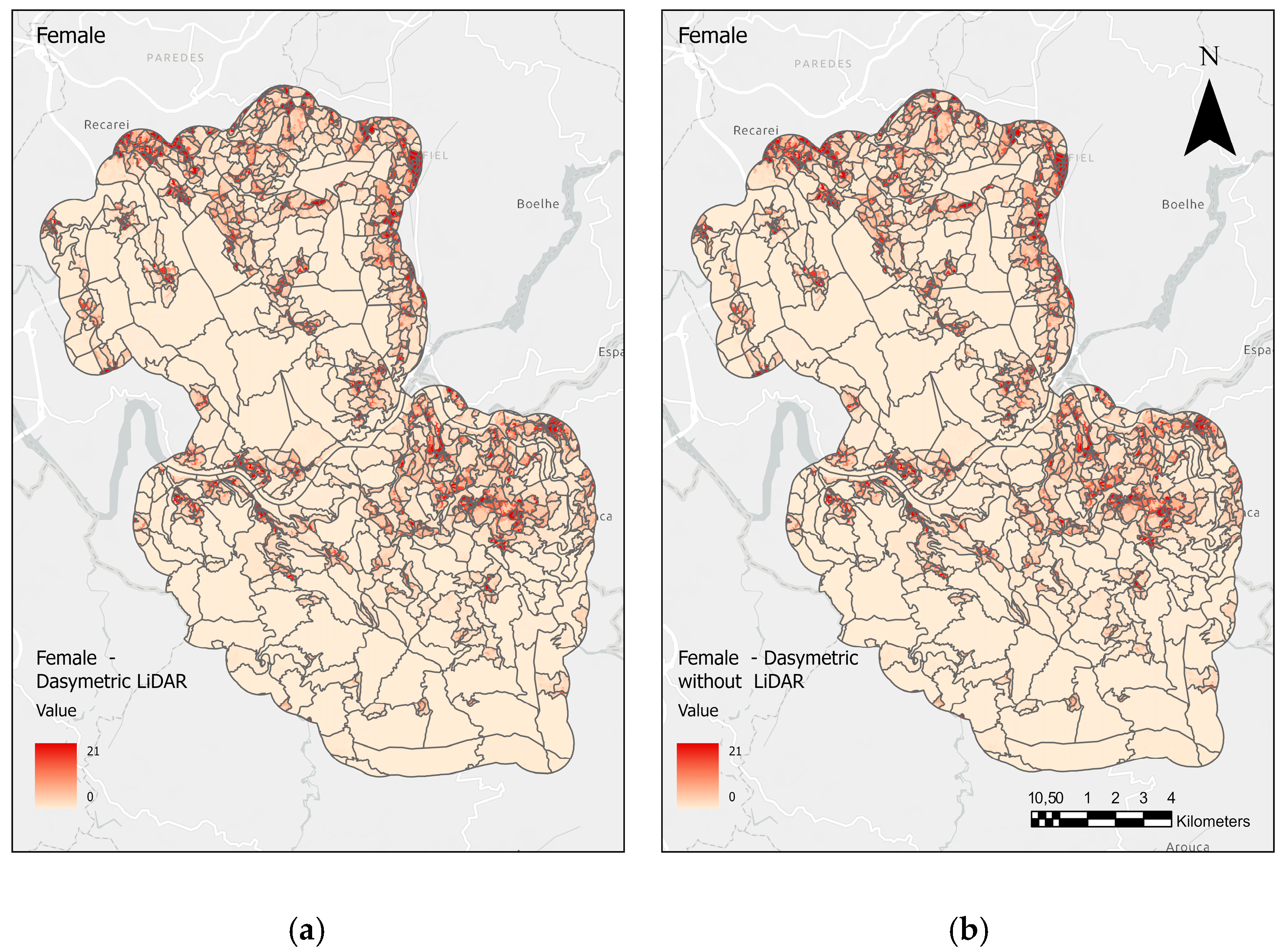
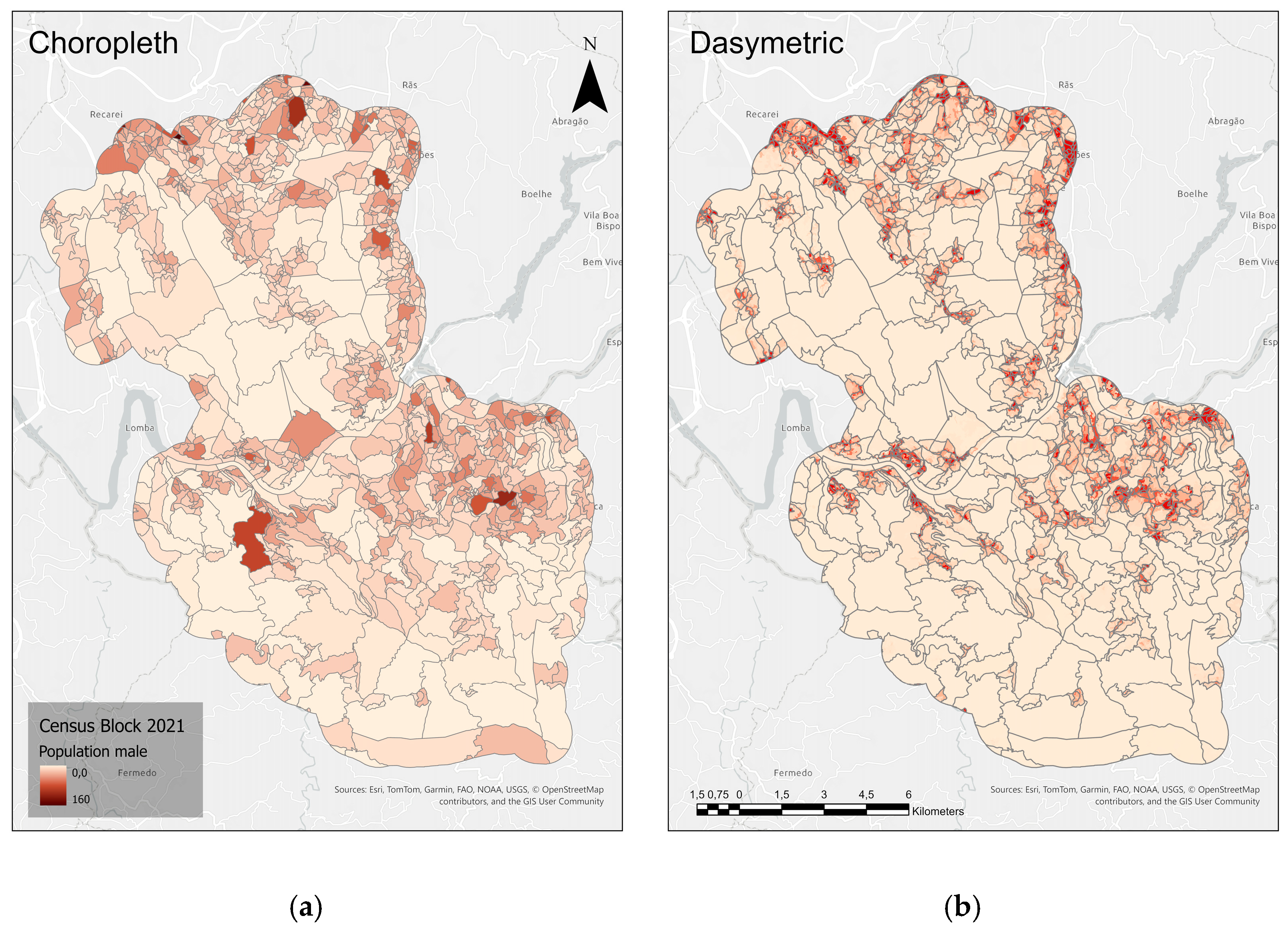
3.1. Choropleth, Dasymetric, WUI, and Wildfire Forecast Maps
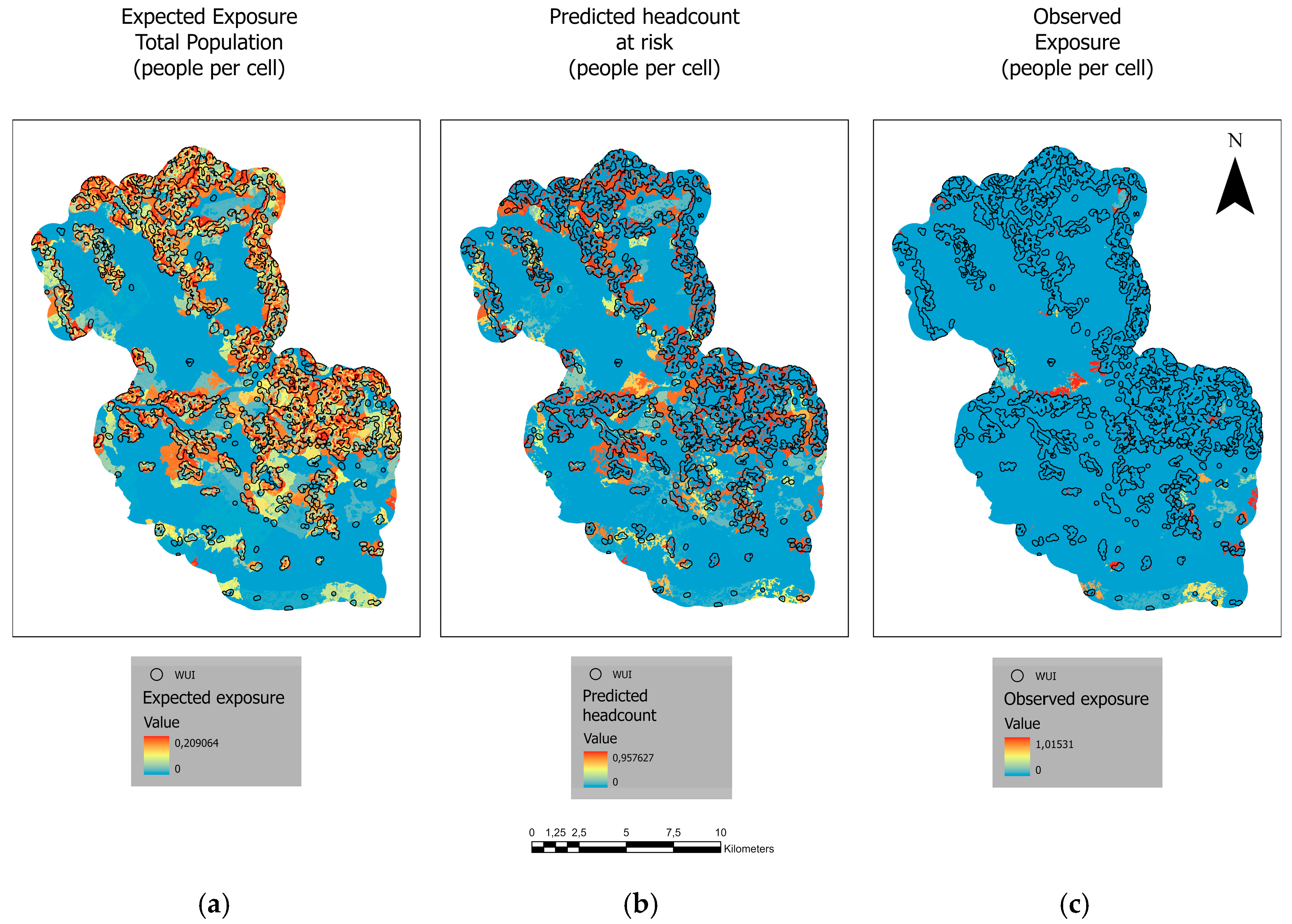
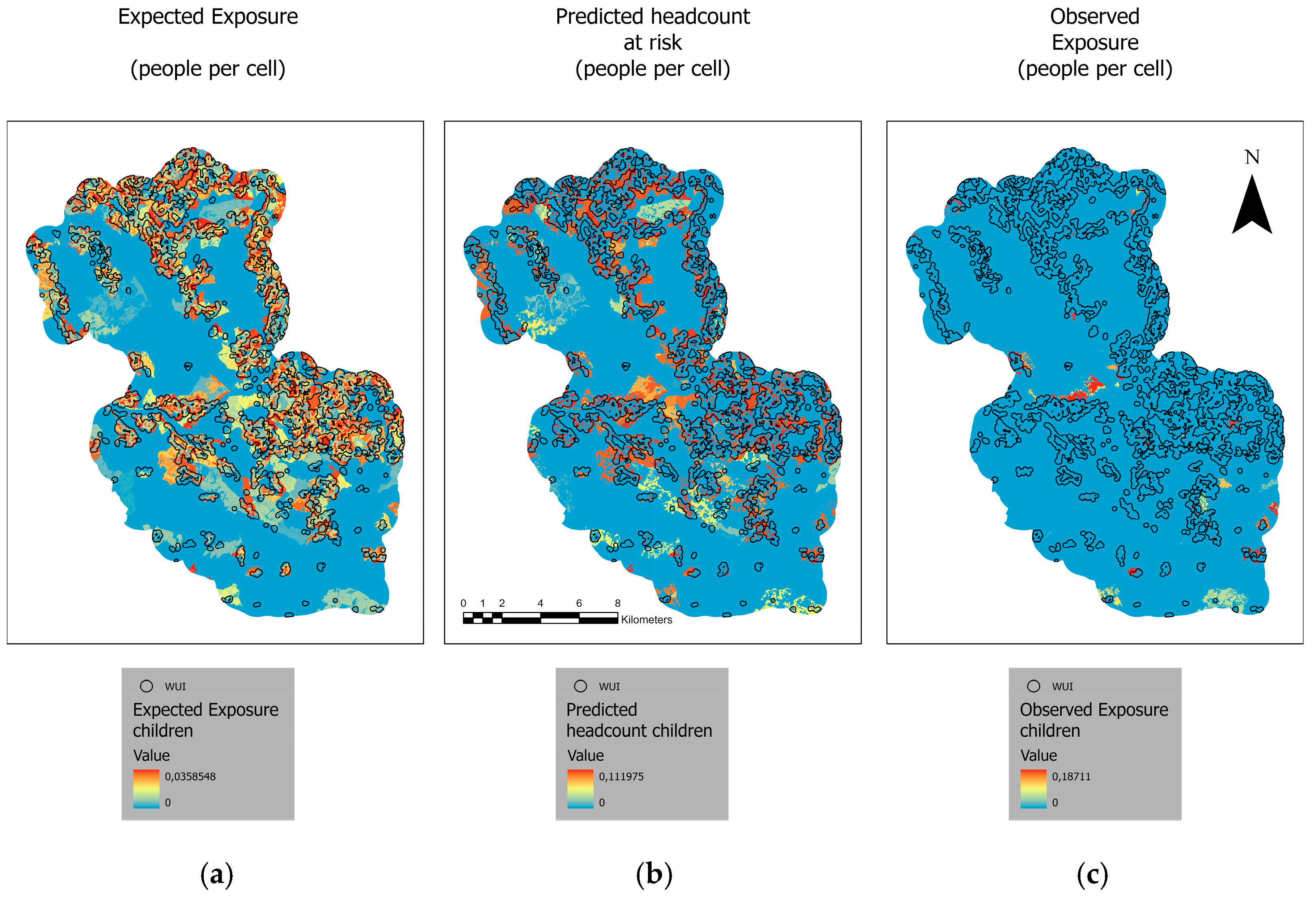
3.2. Expected Exposure, Observed Exposure, and Exposure to Risk
4. Conclusions
Author Contributions
Funding
Data Availability Statement
Acknowledgments
Conflicts of Interest
Appendix A



References
- Meier, S.; Elliott, R.J.R.; Strobl, E. The Regional Economic Impact of Wildfires: Evidence from Southern Europe. J. Environ. Econ. Manag. 2023, 118, 102787. [Google Scholar] [CrossRef] [Scilit]
- Calviño-Cancela, M.; Chas-Amil, M.L.; García-Martínez, E.D.; Touza, J. Interacting Effects of Topography, Vegetation, Human Activities and Wildland-Urban Interfaces on Wildfire Ignition Risk. For. Ecol. Manag. 2017, 397, 10–17. [Google Scholar] [CrossRef] [Scilit]
- Radeloff, V.C.; Helmers, D.P.; Anu Kramer, H.; Mockrin, M.H.; Alexandre, P.M.; Bar-Massada, A.; Butsic, V.; Hawbaker, T.J.; Martinuzzi, S.; Syphard, A.D.; et al. Rapid Growth of the US Wildland-Urban Interface Raises Wildfire Risk. Proc. Natl. Acad. Sci. USA 2018, 115, 3314–3319. [Google Scholar] [CrossRef] [Scilit] [PubMed]
- Argañaraz, J.P.; Radeloff, V.C.; Bar-Massada, A.; Gavier-Pizarro, G.I.; Scavuzzo, C.M.; Bellis, L.M. Assessing Wildfire Exposure in the Wildland-Urban Interface Area of the Mountains of Central Argentina. J. Environ. Manag. 2017, 196, 499–510. [Google Scholar] [CrossRef] [Scilit] [PubMed]
- Modugno, S.; Balzter, H.; Cole, B.; Borrelli, P. Mapping Regional Patterns of Large Forest Fires in Wildland-Urban Interface Areas in Europe. J. Environ. Manag. 2016, 172, 112–126. [Google Scholar] [CrossRef] [Scilit]
- Pereira, J.M.C.; Alexandre, P.M.; Campagnolo, M.L.; Bar-Massada, A.; Radeloff, V.C.; Silva, P.C. Defining and Mapping the Wildland-Urban Interface in Portugal. In Advances in Forest Fire Research 2018; Imprensa da Universidade de Coimbra: Coimbra, Portugal, 2018; pp. 742–749. [Google Scholar]
- Chas-Amil, M.L.; Nogueira-Moure, E.; Prestemon, J.P.; Touza, J. Spatial Patterns of Social Vulnerability in Relation to Wildfire Risk and Wildland-Urban Interface Presence. Landsc. Urban Plan. 2022, 228, 104577. [Google Scholar] [CrossRef] [Scilit]
- Schug, F.; Bar-Massada, A.; Carlson, A.R.; Cox, H.; Hawbaker, T.J.; Helmers, D.; Hostert, P.; Kaim, D.; Kasraee, N.K.; Martinuzzi, S.; et al. The Global Wildland–Urban Interface. Nature 2023, 621, 94–99. [Google Scholar] [CrossRef] [Scilit]
- Hanberry, B.B. Reclassifying the Wildland-Urban Interface Using Fire Occurrences for the United States. Land 2020, 9, 225. [Google Scholar] [CrossRef] [Scilit]
- Badia, A.; Pallares-Barbera, M.; Valldeperas, N.; Gisbert, M. Wildfires in the Wildland-Urban Interface in Catalonia: Vulnerability Analysis Based on Land Use and Land Cover Change. Sci. Total Environ. 2019, 673, 184–196. [Google Scholar] [CrossRef] [Scilit]
- Parente, J.; Pereira, M.G.; Amraoui, M.; Tedim, F. Negligent and Intentional Fires in Portugal: Spatial Distribution Characterization. Sci. Total Environ. 2018, 624, 424–437. [Google Scholar] [CrossRef] [Scilit]
- ESA Copernicus Data Space Ecosystem Browser. Available online: https://browser.dataspace.copernicus.eu/ (accessed on 5 November 2024).
- Xu, Z.; Li, J.; Cheng, S.; Rui, X.; Zhao, Y.; He, H.; Guan, H.; Sharma, A.; Erxleben, M.; Chang, R.; et al. Deep Learning for Wildfire Risk Prediction: Integrating Remote Sensing and Environmental Data. ISPRS J. Photogramm. Remote Sens. 2025, 227, 632–677. [Google Scholar] [CrossRef] [Scilit]
- Uehara, T.D.T.; Körting, T.S.; Soares, A.d.R.; Quevedo, R.P. Time-Series Metrics Applied to Land Use and Land Cover Mapping with Focus on Landslide Detection. J. Appl. Remote Sens. 2022, 16, 034518. [Google Scholar] [CrossRef] [Scilit]
- Wulder, M.A.; Bater, C.W.; Coops, N.C.; Hilker, T.; White, J.C. The Role of LiDAR in Sustainable Forest Management. For. Chron. 2008, 84, 807–826. [Google Scholar] [CrossRef] [Scilit]
- Nunes, A.N.; Figueiredo, A.; Pinto, C.; Lourenço, L. Assessing Wildfire Hazard in the Wildland–Urban Interfaces (WUIs) of Central Portugal. Forests 2023, 14, 1106. [Google Scholar] [CrossRef] [Scilit]
- Tarsha Kurdi, F.; Lewandowicz, E.; Gharineiat, Z.; Shan, J. High-Resolution Building Indicator Mapping Using Airborne LiDAR Data. Electronics 2025, 14, 1821. [Google Scholar] [CrossRef] [Scilit]
- Han, S.Y.; Rey, S.; Knaap, E.; Kang, W.; Wolf, L. Adaptive Choropleth Mapper: An Open-Source Web-Based Tool for Synchronous Exploration of Multiple Variables at Multiple Spatial Extents. ISPRS Int. J. Geo-Inf. 2019, 8, 509. [Google Scholar] [CrossRef] [Scilit]
- Bonnevie, I.M.; Hansen, H.S.; Schrøder, L. Dasymetric Algorithms Using Land Cover to Estimate Human Population at Smaller Spatial Scales. ISPRS Int. J. Geo-Inf. 2024, 13, 427. [Google Scholar] [CrossRef] [Scilit]
- Reiter, D.; Jehling, M.; Hecht, R. Benefits of Using Address-Based Dasymetric Mapping in Micro-Level Census Disaggregation. AGILE GISci. Ser. 2023, 4, 38. [Google Scholar] [CrossRef] [Scilit]
- Monteiro, J.; Martins, B.; Murrieta-Flores, P.; Pires, J.M. Spatial Disaggregation of Historical Census Data Leveraging Multiple Sources of Ancillary Information. ISPRS Int. J. Geo-Inf. 2019, 8, 327. [Google Scholar] [CrossRef] [Scilit]
- Pirowski, T.; Szypuła, B. Dasymetric Population Mapping Using Building Data. Ann. Am. Assoc. Geogr. 2024, 114, 1001–1019. [Google Scholar] [CrossRef] [Scilit]
- Cartagena-Colón, M.; Mattei, H.; Wang, C. Dasymetric Mapping of Population Using Land Cover Data in JBNERR, Puerto Rico during 1990–2010. Land 2022, 11, 2301. [Google Scholar] [CrossRef] [Scilit]
- Mennis, J. Generating Surface Models of Population Using Dasymetric Mapping. Prof. Geogr. 2003, 55, 31–42. [Google Scholar] [CrossRef] [Scilit]
- Liu, C.; Chen, Y.; Wei, Y.; Chen, F. Spatial Population Distribution Data Disaggregation Based on SDGSAT-1 Nighttime Light and Land Use Data Using Guilin, China, as an Example. Remote Sens. 2023, 15, 2926. [Google Scholar] [CrossRef] [Scilit]
- Pascual, A.; Tóth, S.F. Using Mixed Integer Programming and Airborne Laser Scanning to Generate Forest Management Units. J. For. Res. 2022, 33, 217–226. [Google Scholar] [CrossRef] [Scilit]
- Bont, L.G.; Blattert, C.; Rath, L.; Schweier, J. Automatic Detection of Forest Management Units to Optimally Coordinate Planning and Operations in Forest Enterprises. J. Environ. Manag. 2024, 372, 123276. [Google Scholar] [CrossRef] [Scilit] [PubMed]
- McGee, T.K. Public Engagement in Neighbourhood Level Wildfire Mitigation and Preparedness: Case Studies from Canada, the US and Australia. J. Environ. Manag. 2011, 92, 2524–2532. [Google Scholar] [CrossRef] [Scilit]
- Fernández-álvarez, M.; Armesto, J.; Picos, J. LiDAR-Based Wildfire Prevention in WUI: The Automatic Detection, Measurement and Evaluation of Forest Fuels. Forests 2019, 10, 148. [Google Scholar] [CrossRef] [Scilit]
- Calkin, D.E.; Cohen, J.D.; Finney, M.A.; Thompson, M.P. How Risk Management Can Prevent Future Wildfire Disasters in the Wildland-Urban Interface. Proc. Natl. Acad. Sci. USA 2014, 111, 746–751. [Google Scholar] [CrossRef] [Scilit]
- Murray, A.T.; Baik, J.; Echeverri Figueroa, V.; Rini, D.; Moritz, M.A.; Roberts, D.A.; Sweeney, S.H.; Carvalho, L.M.V.; Jones, C. Developing Effective Wildfire Risk Mitigation Plans for the Wildland Urban Interface. Int. J. Appl. Earth Obs. Geoinf. 2023, 124, 103536. [Google Scholar] [CrossRef] [Scilit]
- Pavani-Biju, B.; Borges, J.G.; Marques, S.; Teodoro, A.C. Fire Risk Analysis Based on a Neural Network Framework and Remote Sensing Data. Department of Geosciences, Environment and Land Planning, University of Porto, 4169-007 Porto, Portugal. 2025; manuscript in preparation.
- Pavani-Biju, B.; Borges, J.G.; Marques, S.; Teodoro, A.C. Enhancing Forest Site Classification in Northwest Portugal: A Geostatistical Approach Employing Cokriging. Sustainability 2024, 16, 6423. [Google Scholar] [CrossRef] [Scilit]
- Marques, S.; Marto, M.; Bushenkov, V.; Mcdill, M.; Borges, J.G. Addressing Wildfire Risk in Forest Management Planning with Multiple Criteria Decision Making Methods. Sustainability 2017, 9, 298. [Google Scholar] [CrossRef] [Scilit]
- Instituto Nacional de Estatística. Indicadores Censo 2021; Instituto Nacional de Estatística: Lisboa, Portugal, 2022.
- ICNF. Relatório Extraordinário Provisório de Incêndios Florestais–2017; ICNF: Lisboa, Portugal, 2017. [Google Scholar]
- Legrand, J. Bayesian Spatiotemporal Modelling of Wildfire Occurrences and Sizes for Projections under Climate Change: A Step-by-Step Marked Point Process Approach Using INLA-SPDE. Ph.D. Thesis, Université Paul Sabatier, Toulouse, France, 2023. [Google Scholar]





| Equations | |
|---|---|
| Equation (1) | |
| Equation (2) | |
| Equation (3) | |
| Equation (4) | |
| Equation (5) | |
| Classes | |
|---|---|
| Agriculture | 15 |
| Bare Land | 5 |
| Buildings | 31 |
| Forest | 9 |
| Shrubland | 4 |
| Urban Area | 36 |
| Classes | |
|---|---|
| Agriculture | 20 |
| Bare Land | 8 |
| Forest | 13 |
| Shrubland | 7 |
| Urban Area | 52 |
| Expected Exposure—AOI | Expected Exposure—WUI | Predicted Headcount at Risk—AOI | Predicted Headcount at Risk—WUI | Observed Exposure—AOI | Observed Exposure—WUI | |
|---|---|---|---|---|---|---|
| Population Groups | Number of Inhabitants | |||||
| Total | 1526 | 821 | 6276 | 3428 | 685 | 228 |
| Male | 747 | 401 | 3081 | 1675 | 329 | 109 |
| Female | 778 | 420 | 3194 | 1753 | 356 | 118 |
| Elderly | 304 | 165 | 1265 | 697 | 146 | 47 |
| Children | 183 | 99 | 741 | 410 | 78 | 30 |
| Population Groups | Expected Exposure—AOI | Expected Exposure—WUI | Predicted Headcount at Risk—AOI | Predicted Headcount at Risk—WUI | Observed Exposure—AOI | Observed Exposure—WUI | ||||||
|---|---|---|---|---|---|---|---|---|---|---|---|---|
| Rate | Percentage of Exposure | Rate | Percentage of Exposure | Rate | Percentage of Exposure | Rate | Percentage of Exposure | Rate | Percentage of Exposure | Rate | Percentage of Exposure | |
| Total | 3 | 46 | 2.7 | 54 | 25.3 | 45.4 | 11.3 | 54.6 | 1.34 | 76.7 | 0.75 | 33.3 |
| Male | 3 | 47 | 2.7 | 53 | 12.5 | 45.6 | 11.4 | 54.4 | 1.33 | 77 | 0.74 | 33 |
| Female | 2.9 | 46 | 2.7 | 54 | 15.5 | 45 | 11.2 | 55 | 1.35 | 76.6 | 0.76 | 33.4 |
| Elderly | 3.1 | 45.7 | 2.8 | 54.3 | 12.8 | 44.9 | 11.8 | 55.1 | 1.5 | 77.3 | 0.3 | 32.7 |
| Children | 2.9 | 45.8 | 2.7 | 54.2 | 11.7 | 44.6 | 6.59 | 55.4 | 1.2 | 73.3 | 0.77 | 36.7 |
| Population Groups | Expected Exposure—AOI | Expected Exposure—WUI | Predicted Headcount at Risk—AOI | Predicted Headcount at Risk—WUI | Observed Exposure—AOI | Observed Exposure—WUI | ||||||
|---|---|---|---|---|---|---|---|---|---|---|---|---|
| Rate | Percentage of Exposure | Rate | Percentage of Exposure | Rate | Percentage of Exposure | Rate | Percentage of Exposure | Rate | Percentage of Exposure | Rate | Percentage of Exposure | |
| Total | 10.4 | 41 | 10.6 | 59 | 12.6 | 46 | 11.77 | 54 | 1.34 | 77.5 | 0.74 | 32.5 |
| Male | 10.3 | 41 | 10.3 | 59 | 12.7 | 46 | 11.6 | 54 | 1.30 | 78 | 0.73 | 32 |
| Female | 10.4 | 41 | 10.4 | 59 | 12.4 | 77.5 | 11.5 | 32.5 | 1.34 | 77.5 | 0.74 | 32.5 |
| Elderly | 10.4 | 31 | 12 | 69 | 13.1 | 45.3 | 12 | 54.7 | 1.5 | 78 | 0.80 | 32 |
| Children | 10.3 | 45.8 | 5.1 | 54.2 | 12 | 100 | 0 | 0 | 1.2 | 93.6 | 0.13 | 6.4 |
Disclaimer/Publisher’s Note: The statements, opinions and data contained in all publications are solely those of the individual author(s) and contributor(s) and not of MDPI and/or the editor(s). MDPI and/or the editor(s) disclaim responsibility for any injury to people or property resulting from any ideas, methods, instructions or products referred to in the content. |
© 2026 by the authors. Licensee MDPI, Basel, Switzerland. This article is an open access article distributed under the terms and conditions of the Creative Commons Attribution (CC BY) license.
Share and Cite
Pavani-Biju, B.; Borges, J.G.; Marques, S.; Teodoro, A.C. Dasymetric Mapping for People-Centered Wildfire Risk Assessment Case Study: Northern Portugal. Land 2026, 15, 511. https://doi.org/10.3390/land15030511
Pavani-Biju B, Borges JG, Marques S, Teodoro AC. Dasymetric Mapping for People-Centered Wildfire Risk Assessment Case Study: Northern Portugal. Land. 2026; 15(3):511. https://doi.org/10.3390/land15030511
Chicago/Turabian StylePavani-Biju, Barbara, José G. Borges, Susete Marques, and Ana C. Teodoro. 2026. "Dasymetric Mapping for People-Centered Wildfire Risk Assessment Case Study: Northern Portugal" Land 15, no. 3: 511. https://doi.org/10.3390/land15030511
APA StylePavani-Biju, B., Borges, J. G., Marques, S., & Teodoro, A. C. (2026). Dasymetric Mapping for People-Centered Wildfire Risk Assessment Case Study: Northern Portugal. Land, 15(3), 511. https://doi.org/10.3390/land15030511