Abstract
Optimizing the regional spatial pattern of land use and high-quality economic development requires an accurate understanding of the multifunctional evolution of land use. Based on remote sensing data and socio-economic data from 2000 to 2023, this study utilizes a land transfer matrix, an evaluation index system, an obstacle degree model, and regression analysis to deeply explore the spatial distribution characteristics and influencing factors of the production–living–ecological functions (PLEF) in the Yangtze River Economic Belt (YREB) over the 23-year period. The results show the following: ① the living function area of the YREB has increased by 22,400 km2, while the production function area has decreased by 20,600 km2, and the ecological function area has decreased by 1800 km2. ② The production and living function spaces are characterized by high values in the eastern region and low values in the western region, and the ecological function space is characterized by high values in the western region and low values in the eastern region. ③ In the YREB, production function was the main obstacle to the PLEF between 2000 and 2023. ④ Population growth, economic development, agricultural technology, and agricultural efficiency are the main factors that influence the spatial and temporal evolution of the PLEF. This study suggests exploring an interactive compensation mechanism of the PLEF that combines the government and the market to form a differentiated development strategy.
1. Introduction
Production, living, and ecological spaces constitute the three dominant activity domains within cities. Owing to their distinct service targets, each exhibits unique characteristics and performs differentiated roles in urban development. Therefore, the production–living–ecological functions (PLEF) encompass the full spectrum of human socio-economic and cultural activities, serving as the foundational carrier of societal and economic interaction. However, rapid urbanization has intensified human–land conflicts, leading to an imbalance among the PLEF [1]. Consequently, accurate characterization of the multifunctional evolution of land use is imperative for harmonizing human–land relationships and optimizing territorial spatial planning [2].
The theoretical development of the PLEF originates from the paradigm of land multifunctionality, the essence of which lies in evaluating and recognizing the multiple roles performed by land. In the 1970s, relevant studies mainly focused on the ecological, economic, and social functions of agricultural land, emphasizing that land use should take into account the efficiency of resource use and ecological environmental protection. In the 21st century, research on “multifunctional agriculture” and “sustainable land use” has been systematized gradually, promoting the theoretical construction of the concept of multifunctional spatial development. In summary, the PLEF is an important indicator of the development and optimization of national territorial space by identifying the multifunctional attributes of land use and quantifying the distribution characteristics of dominant functions in regional land use [3,4].
Currently, the main research contents of the PLEF cover the following aspects: the connotation definition, the evolution of spatial patterns, the assessment of national territorial space quality, and the optimization strategies for spatial patterns of the PLEF. Currently, the main research contents of the PLEF cover four aspects: the connotation definition, the evolution of spatial pattern, the assessment of national territorial space quality, and the optimization strategies for spatial patterns of the PLEF. Firstly, in terms of the definition of the PLEF [5,6], based on a review of the literature, the majority of experts have pointed out that the core of the PLEF lies in the proportion of products and services provided for human activities during the land use stage. If the primary use of land is to produce goods that meet the demands of social production, it is considered as the production function. If the main role of land is to supply basic resources necessary for human living, it is classified as the living function. When the main objective of land is to maintain the fundamental functions of ecosystems and meet the spiritual needs of humans, it is identified as the ecological function [6,7].
In terms of the spatial distribution identification and evolutionary trends of the PLEF [8,9], the current methods can be summarized into two major categories: direct mapping methods and indirect inference methods. The essence of the direct-mapping approach lies in evaluating and comparing the magnitudes of diverse territorial-space functional values to identify the dominant function. The core of the direct mapping method is to evaluate and compare the magnitudes of functional values of different national territorial spaces to determine their dominant functions. Indicator representation generally takes administrative regions as the basic unit, employs socio-economic data, and establishes an indicator system to quantify the values of the PLEF.
Thirdly, from the aspect of national territorial space quality assessment [10,11], based on the identification of the spatial distribution of the PLEF, some scholars have further employed methods such as comprehensive indicator evaluation and resident perception surveys to assess the spatial quality of these functions. This has facilitated the transition of PLESF from being dominated by a single function to a more integrated application. Meanwhile, to explore the interactive relationships among the PLEF, some scholars have adopted methods such as the coupling coordination degree model and the niche width model to study their interactive effects [12,13].
Despite the existing literature achieving certain research outcomes regarding the PLEF, there are still some research gaps, which mainly include the following: (1) Existing studies primarily focus on administrative units such as provinces, cities, and districts, thereby ignoring the upstream–downstream influence effects of the PLEF within a river basin; (2) the intrinsic driving mechanisms and related influencing factors of the spatiotemporal evolution of the PLEF have not been considered; and (3) the layout optimization of the PLEF is mostly confined to internal adjustments within administrative boundaries, neglecting the optimal layout and their coordinated development between the upstream and downstream areas of a river basin.
Based on this, this study employs Landsat data and socio-economic data from 2000 to 2023 and utilizes methods such as a land transfer matrix, an evaluation index system, an obstacle degree model, and influence mechanisms to deeply explore the spatial distribution characteristics and influencing factors of the PLEF in the YREB over the 23-year period. In this study, we aim to support high-quality economic development through the optimization of regional territorial spatial patterns.
2. Materials and Methods
2.1. Study Area
The Yangtze River Economic Belt (YREB) covers 130 prefecture-level cities in 11 provinces and municipalities, including Shanghai, Jiangsu, Zhejiang, Anhui, Jiangxi, Hubei, Hunan, Chongqing, Sichuan, Yunnan, and Guizhou, with a total land area of approximately 2.0523 million km2, accounting for 21.4% of China’s total land area (Figure 1). The region is characterized by complex topography and significant variations in terrain. The upstream area is dominated by mountains, which are rich in ecological and mineral resources. The midstream area is characterized by hills and abundant arable land resources. The downstream area consists mostly of plains with dense water networks and well-developed economic and trade activities. The upstream, midstream, and downstream regions of the YREB have formed a close economic and trade network through the Yangtze River waterway and land transportation and have gradually developed in a differentiated manner. By the end of 2023, the total population of the YREB was approximately 600 million, and the regional gross domestic product (GDP) was about 48.3 trillion yuan. However, along with rapid economic growth, urbanization and industrialization have caused a number of environmental issues, including disorderly expansion of urban land, loss of land resources, and widespread occupation of ecological areas. Economic development at the expense of environmental degradation has become the main constraint on the coordinated development of the YREB.
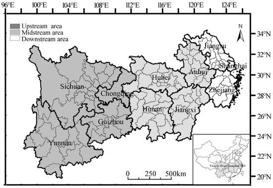
Figure 1.
Locations of study area.
2.2. Data Sources
The dataset used in this study covers two major categories: socio-economic and geographical spatial data.
(1) The land use dataset covers 30 m × 30 m resolution remote sensing data for the years 2000, 2010, and 2023. The land use data for 2000 and 2010 were mainly provided by the Data Center for Resources and Environmental Sciences of the Chinese Academy of Sciences (http://www.resdc.cn, accessed on 13 January 2025). The original Landsat imagery data for 2023 were obtained from the Geospatial Data Cloud platform (http://www.gscloud.cn, accessed on 18 January 2025). Through the Google Earth Engine (GEE) cloud platform, the spatial attributes of the images, such as spectral bands, geodetic coordinate systems, and ground control points, were calibrated and optimized. Based on the spectral reflectance characteristics, background environment, and topographic features of the calibrated images, the land use categories were identified and determined through human–machine collaborative analysis and expert experience. Based on the classification standards of the “Land Use Status Classification” (GB/T 21010-2017) [14], the land use types revealed by the interpreted Landsat imagery data were integrated and summarized into six major categories: arable land, forest land, grassland, water bodies, construction land, and unused land.
(2) Socio-economic data are mainly derived from the “China Statistical Yearbook”, “Rural Statistical Yearbook”, and “Urban Statistical Yearbook” (2000–2023), while missing data are obtained from official government websites.
2.3. Methods
In this study, we quantify the spatial distribution characteristics and influencing factors of the PLEF through the following steps and contents: (1) the transfer patterns and area matrices of the PLEF are quantified using the land transfer matrix (Step 1); (2) the spatial distribution of the PLEF is assessed by using the evaluation index system (Step 2); (3) the main factors hindering the spatiotemporal evolution of the PLEF distribution are identified by using the obstacle degree model (Step 3); (4) the main influencing factors of the PLEF are explored by using regression analysis (Step 4).
The methodological framework of this study is presented in Figure 2.
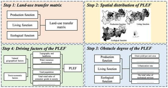
Figure 2.
Methodological framework of this study.
2.3.1. Land Use Transfer Matrix
The extent of the shift in land use patterns can be accurately measured by the land use transfer matrix model. This model operates by organizing the quantities of various land use changes into a matrix format. This matrix tool allows for a deep analysis of land use structure changes as well as their specific scale, beginning at the starting point and ending at the ending point. It can be expressed as follows:
where represents the areas of land use at the beginning and end of the study periods; and represent the land use types at the beginning and end of the study periods, respectively; and represents the number of land use types. Each row of the matrix represents the area information transferred from land use type at the beginning of the study period to other land use types at the end of the period, and each column represents the area information acquired by land use type at the end of the study period from other land use types at the beginning of the period.
2.3.2. Evaluation Index System
Given the complexity of the land use structure and the spatial overlap of land functions, it is often hard to define the scope of land for the PLEF, resulting in the same type of land often serving multiple functions. Therefore, when designing the indicator system for assessing the PLEF, in addition to reflecting the composition of land use, the realization of its functions in space should also be taken into account [15] (Table 1).

Table 1.
The evaluation indicator system of the PLEF.
- (1)
- Production function
In this study, the indicators for the production function include grain yield per unit area, land reclamation rate, industrial configuration, and economic density. Among them, grain yield per unit area reflects the efficiency of agricultural production and serves as a key indicator of agricultural productivity. The land reclamation rate quantifies the extent of land-resource exploitation and thus gauges the effectiveness of land use. Industrial configuration addresses the proportion among economic sectors, revealing the direction and hierarchy of economic development. Economic density measures the intensity of per-capita economic activity within a region [16].
- (2)
- Living function
The indicators for living function include urbanization level, average disposable income of urban and rural residents, number of hospital beds per ten thousand people, per capita retail sales of consumer goods, and transportation land density. The urbanization rate captures the development gap between urban and rural areas and constitutes a pivotal metric for evaluating watershed development levels [17]. The average disposable income of urban and rural residents differentiates regional economic capacity and living standards and is directly linked to human well-being. The number of hospital beds per ten thousand people quantifies the coverage of public health services, serving as a critical indicator of social welfare [18]. Per capita retail sales of consumer goods reflect the vitality of consumer markets and, residents’ living standards. Transportation land density is closely associated with accessibility and exerts a decisive influence on the mobility of social resources and the intensity of economic interactions.
- (3)
- Ecological function
The indicators for ecological function include the total value of ecosystem services and the intensity of agricultural fertilizer use. The total value of ecosystem services provides a comprehensive assessment of the status and service capacity of the ecosystem [19]. Agricultural fertilizer input intensity quantifies the density of chemical fertilizer use within agricultural production systems. Each indicator is weighted using the entropy method. It can be expressed as follows:
where Ui represents the values of the production, living, or ecological functions of the evaluation unit ; represents the standardized value of the indicator of the evaluation unit ; represents the weight of the indicator ; represents the information entropy of the indicator; and represents the proportion of the indicator of the evaluation unit .
2.3.3. Obstacle Degree Model
In order to optimize the spatial layout, it is necessary to detect the main factors hindering the spatial and temporal evolution of the distribution of the PLEF. In this study, the obstacle degree model is used to detect the main factors hindering the spatial and temporal evolution of the distribution of the PLEF in the YREB. It can be expressed as follows:
where is the obstacles degree of the PLEF; is the total weight of the evaluation indicators; and is the standardized value of the individual indicators.
2.3.4. Regression Analysis
As a result of rapid urbanization and highly intensive human activities, land use functions have changed dramatically. Along with the accelerated industrialization and urbanization in the YREB, land for ecological functions has been continuously occupied by land for production and living functions [20]. Moreover, the complex topography, terrain changes, and distribution of water resources in the YREB have also had certain impacts on land use changes. Therefore, it is imperative to explore the main influencing factors of the PLEF in the YREB.
Based on this, this paper selects the following variables from economic, social, and policy aspects to conduct a multiple regression analysis on the evolution of land use in the YREB: total population (), total grain output (), total power of agricultural machinery (), GDP (), disposable income of urban residents (), total retail sales of consumer goods (), value added of agriculture, forestry, animal husbandry, and fishery (), value added of industry (), value added of real estate (), and actual utilization of foreign capital (). It can be expressed as follows:
where is the regression coefficient of the influence factor; is the constant term; and is the residual.
3. Results and Discussion
3.1. Transformation of the PLEF
According to Equation (1), the transfer patterns and area matrices of 130 cities in the YREB during 2000–2023 are shown in Table 2. The YREB is predominantly composed of forest, agricultural, grassland, and water bodies, which make up approximately 47.24%, 29.42%, 15.78%, and 3.95% of the total land area, respectively. In addition, rural land, urban land, and industrial land account for only 4.61% of the total land area. Land use types in 130 cities along the YREB are expected to undergo significant changes between 2000 and 2023. In particular, the main land use types with net area increases were urban, industrial, forest, water bodies, and rural land. Specifically, agricultural land (14,500 km2) and rural land (1800 km2) accounted for most of the increase in urban land area. A total of 0.78 million km2 of agricultural land and 0.33 million km2 of forest land contributed to the increase in industrial land. Forest land area increased mainly due to agricultural land (37,700 km2) and grassland (35,400 km2). The increase in water bodies mainly resulted from agricultural land (8100 km2) and forest land (2400 km2). Most of the increase in rural land area was due to agricultural land (10,500 km2) and forest land (700 km2).
Table 2.
Land transfer matrix changes of the PLEF (km2).
Agriculture and grassland have the largest net area decreases. Specifically, forest land (34,600 km2) and grassland (11,200 km2) account for most of the increase in agricultural land. A total of 0.91 million km2 of agricultural land and 2.58 million km2 of forest land contribute to the increase in grassland. According to relevant studies, in the Pearl River Delta and Yangtze River Delta, urban and industrial land are the primary types of land experiencing net growth, with agricultural land and forests being the secondary sources [21,22].
Over the past 20 years, the PLEF has experienced spatial and temporal dynamics that have resulted in an increase of 22,400 km2 in living space, a decrease of 20,600 km2 in production space, and a decrease of 0.18 million km2 in ecological space. Yang et al. (2020) also found that the area of living functions in the Beijing–Tianjin–Hebei Economic Belt increased significantly, while the area of production and ecological functions decreased overall from 1985 to 2018 [23].
Living functions areas have increased mostly in urban and rural areas, with urban land rapidly expanding and showing an accelerating trend. A decrease in the area of production functions can be attributed to two factors: agricultural land continued to flow out, showing an accelerating trend, while industrial land increased steadily, but at a lower rate than agricultural land. Similarly, the decrease in the area of ecological functions can be divided into two parts: grassland and other land areas continued to flow out, showing an accelerating trend, while forest and water body areas increased gradually, but the increases were much less than the outflows. The expansion of industrial and urban land areas is primarily attributed to the rapid economic growth of China since the reform and opening up, which has led to large-scale land demands for urbanization and industrial production activities [24]. The growth of rural living land is primarily due to the continuous increase in rural population, the rise in household size, and the influx of new residential construction in the early 21st century. At the beginning of the 21st century, the industrial economic foundation in rural areas was weak and not widespread, and labor migration was not prevalent. A large number of rural laborers were engaged in the development of wasteland, which led to the gradual expansion of agricultural land. However, with the rapid development of China’s economy, an increasing number of rural laborers of working age chose to migrate to urban areas for employment, leading to the abandonment and wastage of farmland [25]. Consequently, the area of agricultural land has shown a decreasing trend since the early 21st century [16]. Ecological protection policies have led to a significant increase in water body ecological land. China has undertaken a series of water environment governance measures, and local cities have focused on building aquatic ecosystems. These efforts have contributed to the growth in the area of water body ecological land [26]. The significant reduction in other types of land is mainly due to extensive expansion practices, including overgrazing, excessive reclamation, and extensive mining activities, which have led to land degradation. Additionally, changes in climatic conditions have caused extensive land degradation through desertification and salinization. A significant part of the evolution of woodland and grassland areas can be attributed to urbanization. As urban areas expand, these ecological areas have been affected, although efforts to balance urban development with ecological conservation have been made.
3.2. Spatial Pattern of the PLEF
Figure 3 shows the spatial distribution of the PLEF for 130 cities in the YREB during 2000–2023.
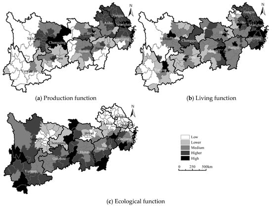
Figure 3.
Spatial pattern of the PLEF.
(1) The production function exhibits a spatial distribution pattern of higher in the east and lower in the west. The production function index in the YREB varies between 0.01 and 0.36, with significant clustering characteristics of high-value and low-value areas. High-value areas (0.05–0.36) are distributed in a belt along the YREB, mainly concentrated in the downstream and midstream regions, including cities such as Wuxi, Nanjing, Wuhan, Changzhou, and Nantong. Low-value areas (<0.03) exhibit significant spatial clustering characteristics, mainly concentrated in the upstream and midstream regions of the YREB, including cities such as Garze, Aba, Enshi, Wenshan, and Fuzhou.
The midstream region of the YREB has a significant advantage in production function, including Anhui, Hubei, Hunan, and Jiangxi. On the one hand, the midstream region is characterized by hilly terrain and abundant water resources, which are suitable for crop growth [27]. Among them, Anhui, Hubei, Hunan, and Jiangxi rank in the top 10 in the country for total grain output, with grain yields per unit area of 10.48 t/hm2, 8.50 t/hm2, 11.61 t/hm2, and 11.21 t/hm2, respectively. On the other hand, the transportation system in the region’s middle reaches is more complete, and intercity transit capacity is stronger, which makes agricultural products easier to process and transport.
(2) A decreasing trend can be seen in the living function index from the eastern plains to the western mountainous areas. The living function index of the YREB falls within the range of 0.03 to 0.32, with a gradual increase in the variability of different regions. The high-value and low-value areas account for 38.46% and 30.77% of the 130 prefecture-level cities, respectively, and exhibit a significant dispersed distribution feature. High-value areas (0.15–0.32) are distributed in a belt along the YREB, mainly concentrated in the downstream and midstream regions, including cities such as Nanjing, Wuhan, Wenzhou, Xiangtan, and Yichang. The terrain of the YREB decreases from west to east, with the eastern region characterized by flat terrain and abundant water resources. In addition, the local town infrastructure is well developed, resulting in good town linkages. Low-value areas (<0.07) are mainly distributed in the upstream region of the YREB, including cities such as Garze, Suzhou, Chuxiong, Qiannan, and Qujing. These regions share common characteristics of high terrain, narrow plains, and inconvenient transportation, leading to low population density and difficulty in forming economies of scale [28]. The downstream region of the YREB has a higher degree of advantage in living functions, including Shanghai, Jiangsu, and Zhejiang. On the one hand, the downstream region has flat terrain, a dense water network, and developed transportation, with frequent economic and trade interactions among cities, forming a convenient living and trading circle. On the other hand, the downstream region fully utilizes the Yangtze River waterway to concentrate agricultural products, natural resources, and living goods from the midstream and upstream regions and transport them to regions such as Europe, America, and Southeast Asia. This has formed globally important trade ports and urban agglomerations, providing employment opportunities and social welfare for a large number of migrant populations [29].
(3) The ecological function index gradually decreases from the western mountainous areas to the eastern plains, ranging from 0.01 to 0.73. The high and low value areas account for 33.07% and 43.85% of the 130 prefecture-level cities, respectively, showing obvious cluster distribution characteristics. High-value areas (0.52–0.73) are distributed in a belt along the YREB, mainly concentrated in the upstream region, including cities such as Lishui, Diqing, Panzhihua, Liangshan, and Zhangjiajie. With its steep topography, abundant water resources, and low total population, the western region has a more complete ecosystem. Low-value areas (<0.23) are mainly distributed in the downstream region of the YREB, including cities such as Jiaxing, Yancheng, Shanghai, Changzhou, and Jingmen. These regions share common characteristics of gentle terrain, convenient transportation, high land development degree, and significant population aggregation [30].
3.3. The Obstacle Degree of the PLEF
According to Figure 4, there is an increasing trend in the obstacle degree to ecological functions, while there is a decreasing trend in the obstacle degree to production and living functions in the YREB. The average obstacle degrees of production, living, and ecological functions in the YREB are 36.18, 31.14, and 20.61, respectively. In 2000 and 2023, the main obstacle factors hindering the improvement of the PLEF in the YREB are production and living functions.
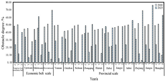
Figure 4.
The obstacle degree of the PLEF.
In the upstream region of the YREB, the obstacle degree of ecological function has shown an increasing trend, while the obstacle degrees of production and living functions have decreased. Specifically, the average obstacle degrees of the PLEF in the upstream region are 39.28, 26.17, and 19.03 in 2000 and 2023, respectively. Therefore, the main obstacle factors hindering the improvement of the PLEF in the upstream region are production and living functions.
In the midstream region, the obstacle degrees of living and ecological functions have increased, while the production function has decreased. The average obstacle degrees of the PLEF in the midstream region are 37.00, 53.27, and 17.10 in 2000 and 2023, respectively. Thus, the main obstacle factors hindering the improvement of the PLEF in the midstream region are living and production functions.
In the downstream region, the obstacle degree of ecological function has increased, while the obstacle degrees of production and living functions have decreased. The average obstacle degrees of the PLEF in the downstream region are 36.92, 32.67, and 37.07 in 2000 and 2023, respectively. Therefore, the main obstacle factors hindering the improvement of the PLEF in the downstream region are ecological and production functions.
Based on the results of Equation (6), the factor with the highest obstacle degree is selected from the 11 factors across the three target layers (Table 3). In 2000, the main target layers hindering the improvement of the PLEF in the YREB are living and production functions, with key factors including per capita disposable income of urban and rural residents (). By 2023, the main target layers hindering the improvement of the PLEF shifted to ecological and production functions, with key factors including the total value of ecosystem services ().
Table 3.
Main obstacles of the PLEF.
The upstream region of the YREB has relatively poor natural endowments, with low initial values for production and living functions. The region has a high proportion of agricultural industries, significant population outflow, and inadequate transportation infrastructure, all of which have hindered the improvement of the PLEF [31]. However, in recent years, there has been a gradual improvement, primarily due to strong national support for the development of the western region. This has led to improved infrastructure, increased external investment, and the promotion of scientific production techniques, which have enhanced production efficiency and irrigation facilities.
The PLEF in the midstream region have remained relatively stable, mainly due to improvements in production functions that have offset declines in ecological functions. The quality and output benefits of arable land have mitigated losses caused by abandoned and occupied farmland. However, the mechanization level of agricultural production technology still needs to be improved, and the intensity of agricultural fertilizer input has exceeded the environmental carrying capacity [32].
The downstream region has relatively high levels of production and living functions but weaker ecological functions. This is primarily due to the occupation of ecological land by production and living functions, which has disrupted ecological systems and reduced the recovery capacity of the ecological environment [33]. This region must integrate production and living functions while optimizing and enhancing ecological performance, thereby fostering the coordinated development of the PLEF.
3.4. Influencing Factors of the PLEF
3.4.1. Topographical Factors
The topography, geomorphology, and climatic conditions of the YREB are the prerequisites for the spatial distribution of the PLEF. The differences in natural resource endowments have led to varying urban development paths in the upstream, midstream, and downstream regions of the YREB.
The upstream region of the YREB is characterized by complex terrain with a large proportion of mountainous areas. As a result, the waterways and ports formed by the Yangtze River have become crucial transportation networks [34]. For example, cities like Chongqing have fully utilized the advantages of the Yangtze River waterways to establish close economic ties with cities such as Wuhan and Shanghai, forming a significant economic belt. Production land can only be concentrated in flat, fertile plain areas, while most cities are built according to the terrain, with limited and highly utilized living land [35].
There is relatively gentle terrain in the midstream region, which is dominated by hills and plains. The internal transportation mainly relies on land routes [13]. The living land is spacious, forming clustered residential areas. The region enjoys a mild climate and fertile soil, which are suitable for large-scale crop cultivation with relatively high yields per unit area [36].
The downstream region has flat terrain with a large proportion of plains. The waterways and ports formed by the Yangtze River have become crucial transportation networks [37]. As a result, there is a significant trade network formed by water in the Yangtze River basin between the east and west banks of the river [38]. The region has fully utilized the advantages of the Yangtze River waterways to establish close economic ties with regions such as Europe, America, and Southeast Asia.
3.4.2. Socio-Economic Factors
The evolution of the PLEF is essentially a change in land use functions. Natural factors determine the inherent attributes of the PLEF, whereas anthropogenic drivers—particularly economic development and regional policies—exert dominant and manipulable influences on land use outcomes. Based on this, this study selects 10 indicators representing the levels of socio-economic development and regional policies for 130 cities in the YREB for the years 2000, 2010, and 2023. Using SPSS 26.0, a principal component analysis (PCA) was conducted to explore the main driving factors influencing the evolution of the PLEF in the YERB. As shown in Table 4, the cumulative explanation of the overall variance by both the first and second principal components exceeds 80% of the overall variance. Therefore, the first two principal components were extracted to ensure that the indicators reflect the complete information of the data.
Table 4.
Load statistics of influencing factors.
Using the varimax rotation method, the principal component loadings for the years 2000, 2010, and 2023 were analyzed. The results indicate that the following indicators are highly positively correlated with the first principal component: Total population (), GDP (), disposable income of urban residents (), total retail sales of consumer goods (), value added of industry (), value added of real estate (), and actual utilization of foreign capital (). In contrast, the following indicators are highly positively correlated with the second principal component: Total grain output (), total power of agricultural machinery () and value added of agriculture, forestry, animal husbandry, and fishery (). Some data show different directional associations with the first and second principal components (Table 5).
Table 5.
Principal component loading matrix.
Based on the multivariate regression model analysis, the social factors influencing the changes in the PLEF of the YREB can be further summarized as population and economy, and agriculture and technology (Figure 5). Specifically, over the 20-year period, the total resident population in the YREB increased by 45.9 million people. In order to improve living conditions, urban land has expanded rapidly. Industrial restructuring and economic development have allocated substantial resources to infrastructure construction. The value added of the industrial and real estate industries increased by 18 and 31 times, respectively [39].
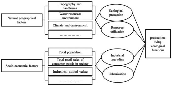
Figure 5.
The underlying mechanisms of the PLEF.
The main factors in the second principal component are agriculture and technology. Driven by agricultural modernization, technological advances have elevated the marginal utility and per-unit productivity of cultivated land. Despite a reduction in arable land area and agricultural labor force, these improvements have maintained a balance between the increasing demand for grain and supply. However, driven by economic benefits, the growth rate of the primary industry (agriculture, forestry, animal husbandry, and fishery) has slowed in recent years. This is mainly due to the extensive land use and relatively low economic value of agricultural production compared to industrial and construction land. Under the backdrop of economic development, cities have prioritized maximizing economic benefits, leading to the occupation of arable land and water bodies by urban land, resulting in a decline in urban ecological environment quality [39]. Although technological advances have raised per-unit grain yields on cultivated land, the concurrent decline in cultivated area and widespread abandonment have slowed aggregate grain production growth in the YREB. This has created a crisis in grain supply and demand [39,40]. According to relevant studies, topography and economic structure are also major factors affecting the spatial distribution of the PLEF in the urban agglomeration of Guangdong–Hong Kong–Macao Greater Bay Area [41].
3.5. Optimization Strategies for the PLEF
The rational allocation of the PLEF within the YREB is facing significant challenges. The current protection and management systems, along with relevant policies, are not yet sufficient to fully meet the needs of protecting the PLEF [40]. To achieve protection objectives, specific strategies for promoting policy coherence, joint governance, and broad participation should be explored.
At present, China’s river basin management practices mainly adopt a model based on administrative divisions. This approach has led to administrative isolation between regions, undermining the coherence and integrity of the ecological network in the Yangtze River Basin. Consequently, this has resulted in fragmented environmental governance within the basin’s economic regions. The integration and cooperation of the YREB can break through the limitations of the traditional administrative regions and achieve the sustainable development of ecological civilization. Specifically, it is imperative to conceptualize the river-basin economic belt as an integrated entity and to establish a supra-regional administrative authority endowed with unified regulatory oversight over all categories of land use, thereby fostering coordinated governance across the upper, middle, and lower reaches of the Yangtze Economic Belt. To achieve strategic spatial connectivity across the region, the Thames Basin in the UK also adopted a collaborative river basin governance model based on marketization and government oversight [42].
Coordinating the interactions among production, living, and ecological functions constitutes the fundamental principle underlying PLEF governance in the YREB and serves as a critical prerequisite for optimizing territorial spatial organization and sustaining economic development [43]. First, an integrated policy framework for sustainable production within the economic belt should be established, focusing on green industrial development, agricultural technologization, and economic-transition strategies [44]. Second, a corresponding policy framework for sustainable living should be implemented, encompassing infrastructure optimization, urban–rural integrated development, and medical-security provisions for urban residents [45]. Third, an ecological sustainability policy framework should be formulated, incorporating vegetation restoration through reforestation, water-pollution control, and standardized ecological-compensation mechanisms. The Tokyo Economic Zone has greened the functional space for production through the establishment of programs such as “zero-carbon factories” and “urban farms” [46].
Taking into account the unique physical and geographic characteristics and economic development of the upstream, midstream, and downstream areas of the YREB, a differentiated management framework that covers both the region and the basin should be built [47]. Within the basin, Shanghai and other core cities should consolidate their leading positions by continuously upgrading advanced manufacturing, strategic emerging industries, and modern services, while simultaneously enhancing their capabilities in technological innovation and high-end service provision to amplify spillover effects. For pivotal cities such as Wuhan, Chongqing, and Chengdu, efforts should focus on deepening intra-basin industrial coordination and expanding their influence over secondary cities to foster stable regional economic growth. Small- and medium-sized cities within the region should form differentiated and characteristic industries based on local resource endowments and cultural characteristics, create regional brand industries, and use the interconnectivity of the YREB to strengthen and expand their city brands. Additionally, the feasibility of implementing the rationalization should also be considered when promoting the optimal layout of the PLEF. For long-term dynamic tracking of the PLEF, it is necessary to establish data sharing platforms or monitoring mechanisms. Further, institutional inertia triggered by regional inequality can be mitigated by promoting localized development paths in each region based on its own resources and setting differentiated management targets. Finally, a strengthened public participation and stakeholder consultation mechanism can improve the social acceptance of the PLEF and facilitate coordinated development of the overall Yangtze River Economic Belt.
4. Conclusions
Based on land remote sensing monitoring and socio-economic data from 2000 to 2023, this study employed land transfer matrices, the indices of the PLEF, and the obstacle degree model to quantitatively analyze the spatiotemporal evolution and obstructive factors of the PLEF in 130 cities within the YREB. Furthermore, a multivariate regression model was utilized to conduct a targeted analysis of the primary influencing factors. The conclusions are as follows:
(1) The area of living function increased by 22,400 km2, with the main sources being urban and rural land. The production function area decreased by 20,600 km2, and the increase in industrial land was much less than the outflow of agricultural land. The ecological function area decreased by 0.18 million km2. The increase in the area of forest land and water is much less than the area of grassland and other land outflows.
(2) The production function area shows a spatial distribution of high in the east and low in the west, and the aggregated distribution of high-value and low-value areas is characterized significantly. The spatial distribution of the living function area is high in the east and low in the west, decreasing from the plains in the east to the mountains in the west. Mountainous areas in the west are characterized by high ecological functions, while the plains in the east are characterized by low ecological functions.
(3) Between 2000 and 2023, the mean obstacle degrees for the production, living, and ecological functions are 36.18%, 31.14%, and 20.61, respectively. Among them, the production and living functions are the main obstacles to the PLEF.
(4) The primary factors influencing the evolution of the PLEF in the YREB include population growth, economic development, agricultural technology, and agricultural efficiency. This study aims to optimize the regional spatial pattern of land use in order to support high-quality economic development. Future research should systematically extend the investigation of synergy mechanisms underlying the PLEF, particularly through the integration of multi-scenario simulations and policy intervention analyses, so as to enhance the foresight of spatial optimization strategies.
Author Contributions
Conceptualization, Y.H., L.Y. and X.G.; data curation, Q.J. and Y.W.; formal analysis, Y.H., L.Y. and G.W.; funding acquisition, Y.H. and Y.W.; investigation, G.W. and X.G.; methodology, Y.H. and L.Y.; project administration, B.Z.; resources, Q.J.; supervision, G.W. and B.Z.; validation, Q.J. and Y.W.; visualization, Y.H. and Y.W.; writing—original draft, Y.H.; writing—review and editing, X.G. and B.Z. All authors have read and agreed to the published version of the manuscript.
Funding
This work was supported by Sichuan Science and Technology Program (2024NSFSC1233); State Key Laboratory of Clean and Efficient Coal Utilization, Taiyuan University of Technology (MJNYSKL202510; MINYSKL202409); Key Laboratory of Digital and Intelligent Management and Ecological Decision Optimization for Baijiu in the Upper Reaches of the Yangtze River (zdsys24-03); Supported byQinghai Provincial Key Laboratory of Media Integration Technology and Communication (YB2024005); Funded by the Xi’an Key Laboratory of Urban Low-Carbon Construction (Chang’an University) Level Enhancement Project (300102284501); Shandong Provincial Key Laboratory of Marine Environment and Geological Engineering (MEGE) (MEGE2024012); The Key Laboratory of Urban Water Supply, Water Saving and Water Environment Governance in the Yangtze River Delta of Ministry of Water Resources, Tongji University (8); Anhui Provincial Key Laboratory of Environment and Population Health Across the Life Course (JKYS20242); Funded By Open Research Fund Program of Key Laboratory of Digital Mapping and Land Information Application, Ministry of Natural Resources (ZRZYBWD202405); Open Fund Project of Wuhan Red Culture Research Center (Key Research Base of Humanities and Social Sciences in Hubei Province’s Universities) (WHHS20241001); Project of the Key Research Base of Philosophy and Social Sciences in Ganzi Prefecture, “Research Center for Ecological Economic Development in Northwest Sichuan of Sichuan Minzu University” (CXBSTJJ202401); Sichuan Center for Zhang Dagian Studies (zdq201905); and the Traditional Crafts Institute, the Key Research Institute Academic Center of Chinese Culture for Sichuan Province (CTGY23YB05).
Data Availability Statement
The original contributions presented in the study are included in the article, further inquiries can be directed to the corresponding author.
Conflicts of Interest
The authors declare no conflicts of interest.
References
- Bole, Y.; Rina, S.; Guga, S.; Na, M.; Fan, S.; Zhang, J. Evaluation of resources, environment, and ecological carrying capacity from the perspective of “production-living-ecology” spaces: A case study of western Jilin Province, China. J. Clean. Prod. 2025, 491, 144770. [Google Scholar] [CrossRef]
- Chai, J.; Wang, Z.; Yang, J.; Zhang, L. Analysis for spatial-temporal changes of grain production and farmland resource: Evidence from Hubei Province, central China. J. Clean. Prod. 2019, 207, 474–482. [Google Scholar] [CrossRef]
- Duan, Y.; Wang, H.; Huang, A.; Xu, Y.; Lu, L.; Ji, Z. Identification and spatial-temporal evolution of rural “production-living-ecological” space from the perspective of villagers’ behavior—A case study of Ertai Town, Zhangjiakou City. Land Use Policy 2021, 106, 105457. [Google Scholar] [CrossRef]
- Fu, J.; Bu, Z.; Jiang, D.; Lin, G.; Li, X. Sustainable land use diagnosis based on the perspective of production–living–ecological spaces in China. Land Use Policy 2022, 122, 106386. [Google Scholar] [CrossRef]
- Gao, M.; Li, C.; Li, Y.; Wen, S.; Zhang, Y.; Liu, L.; Zhang, J.; Chen, M.; Yang, J. Integration of ecological restoration and landscape aesthetics: Mechanisms of microplastic retention by optimization of aquatic plants landscape design in urban constructed wetlands—A case study of the living water park in Chengdu. Sci. Total Environ. 2024, 957, 177331. [Google Scholar] [CrossRef] [PubMed]
- Ge, K.; Wang, Y.; Liu, X.; Lu, X.; Ke, S. Spatio-temporal differences and convergence mechanisms of green transition of urban land use against the background of industrial integration: A case study of the Yangtze River Economic Belt in China. Ecol. Indic. 2024, 159, 111727. [Google Scholar] [CrossRef]
- He, Y.; Wu, L.; Liang, Y.; Zheng, Y.; Zhang, L. Spatial suitability between water supply pressure and waterworks water supply capacity in the Guangdong-Hong Kong-Macau Greater Bay Area: Spatial-temporal evolution pattern, driving mechanism and Implications. J. Clean. Prod. 2024, 434, 140317. [Google Scholar] [CrossRef]
- Lan, G.; Xiao, Y.; Ci, X.; Zhang, Y.; Xia, J. Spatial and temporal differentiation characteristics of green development levels in urban agglomerations within the Yangtze River economic Belt and analysis of influencing factors. Ecol. Indic. 2024, 166, 112552. [Google Scholar] [CrossRef]
- Li, Y.; Zhang, S.; Zhao, J.; Zhang, G.; Qu, G.; Ma, S.; Liu, X. Spatiotemporal evolution and Sustainably comprehensive zoning optimization of production–living–ecological functions in the Mountain–Flatland areas. Heliyon 2024, 10, e23425. [Google Scholar] [CrossRef]
- Liang, Y.; Chai, D.; Zhou, X.; Ning, Y. Potential conflict diagnosis, simulation optimization and coordination of production-living-ecological space in gully areas of the Loess Plateau, China. Environ. Dev. 2024, 52, 101099. [Google Scholar] [CrossRef]
- Luo, X.; Le, F.; Zhang, Y.; Zhang, H.; Zhai, J.; Luo, Y. Multi-scenario analysis and optimization strategy of ecological security pattern in the Weihe river basin. J. Environ. Manag. 2024, 366, 121813. [Google Scholar] [CrossRef] [PubMed]
- Li, J.; Sun, W.; Li, M.; Meng, L. Coupling coordination degree of production, living and ecological spaces and its influencing factors in the Yellow River Basin. J. Clean. Prod. 2021, 298, 126803. [Google Scholar] [CrossRef]
- Yang, Y.; Bao, W.; Liu, Y. Coupling coordination analysis of rural production-living-ecological space in the Beijing-Tianjin-Hebei region. Ecol. Indic. 2020, 117, 106512. [Google Scholar] [CrossRef]
- GB/T21010-2017; Current Land Use Classification. China National Institute of Standardization: Beijing, China, 2017.
- Ma, Z.; Yang, Z.; Li, Q.; Tu, X.; Xu, Y. Exploring the temporal-spatial characteristics and determinants of high-quality development of city clusters in China. Heliyon 2024, 10, e37742. [Google Scholar] [CrossRef]
- Ariken, M.; Zhang, F.; Chan, N.W.; Kung, H.-T. Coupling coordination analysis and spatio-temporal heterogeneity between urbanization and eco-environment along the silk road economic belt in China. Ecol. Indic. 2021, 121, 107191. [Google Scholar] [CrossRef]
- Huang, Y.; Gan, X.; Niu, S.; Hao, D.; Zhou, B. Incorporating Ecosystem Service Multifunctionality and Its Response to Urbanization to Identify Coordinated Economic, Societal, and Environmental Relationships in China. Forests 2022, 13, 707. [Google Scholar] [CrossRef]
- Wu, W.; Huang, Y.; Zhang, Y.; Zhou, B. Research on the coupling relationship and interaction between urbanization and eco-environment in urban agglomerations: A case study of the Chengdu-Chongqing urban agglomeration. PLoS ONE 2024, 19, e0301287. [Google Scholar] [CrossRef]
- Costanza, R.; Mageau, M. What is a healthy ecosystem? Aquat. Ecol. 1999, 33, 105–115. [Google Scholar] [CrossRef]
- Ou, D.; Zhang, Q.; Tang, H.; Qin, J.; Yu, D.; Deng, O.; Gao, X.; Liu, T. Ecological spatial intensive use optimization modeling with framework of cellular automata for coordinating ecological protection and economic development. Sci. Total Environ. 2023, 857, 159319. [Google Scholar] [CrossRef]
- Hu, P.; Li, F.; Sun, X.; Liu, Y.; Chen, X.; Hu, D. Assessment of Land-Use/Cover Changes and Its Ecological Effect in Rapidly Urbanized Areas—Taking Pearl River Delta Urban Agglomeration as a Case. Sustainability 2021, 13, 5075. [Google Scholar] [CrossRef]
- He, X.; Li, J.; Guan, J.; Liu, Y.; Tian, P.; Ai, S.; Gong, H. Land Use Dynamics and Ecosystem Service Value Changes in the Yangtze River Delta Urban Agglomeration Under Different Scenarios. Chin. Geogr. Sci. 2024, 34, 1105–1118. [Google Scholar] [CrossRef]
- Yang, Y.; Bao, W.; Li, Y.; Wang, Y.; Chen, Z. Land Use Transition and Its Eco-Environmental Effects in the Beijing–Tianjin–Hebei Urban Agglomeration: A Production–Living–Ecological Perspective. Land 2020, 9, 285. [Google Scholar] [CrossRef]
- Sun, X.; Wang, Y. Spatio-temporal characteristics and analysis of influencing factors of inclusive green growth in China’s oil and gas resource industry. Ecol. Indic. 2025, 170, 112982. [Google Scholar] [CrossRef]
- Tan, S.; Liu, Q.; Han, S. Spatial-temporal evolution of coupling relationship between land development intensity and resources environment carrying capacity in China. J. Environ. Manag. 2022, 301, 113778. [Google Scholar] [CrossRef] [PubMed]
- Tang, L.; Liang, G.; Gu, G.; Xu, J.; Duan, L.; Zhang, X.; Yang, X.; Lu, R. Study on the spatial-temporal evolution characteristics, patterns, and driving mechanisms of ecological environment of the Ecological Security Barriers on China’s Land Borders. Environ. Impact Assess. Rev. 2023, 103, 107267. [Google Scholar] [CrossRef]
- Tian, F.; Li, M.; Han, X.; Liu, H.; Mo, B. A Production–Living–Ecological Space Model for Land-Use Optimisation: A case study of the core Tumen River region in China. Ecol. Model. 2020, 437, 109310. [Google Scholar] [CrossRef]
- Wang, J.; Sun, Q.; Zou, L. Spatial-temporal evolution and driving mechanism of rural production-living-ecological space in Pingtan islands, China. Habitat Int. 2023, 137, 102833. [Google Scholar] [CrossRef]
- Wang, J.; Wang, W.; Zhang, S.; Wang, Y.; Sun, Z.; Wu, B. Spatial and temporal changes and development predictions of urban green spaces in Jinan City, Shandong, China. Ecol. Indic. 2023, 152, 110373. [Google Scholar] [CrossRef]
- Wang, M.; Huang, X. Inhibit or promote: Spatial impacts of multifunctional farmland use transition on grain production from the perspective of major function-oriented zoning. Habitat Int. 2024, 152, 103172. [Google Scholar] [CrossRef]
- Wu, J.; Bai, Z. Spatial and temporal changes of the ecological footprint of China’s resource-based cities in the process of urbanization. Resour. Policy 2022, 75, 102491. [Google Scholar] [CrossRef]
- Wu, J.; Zhang, D.; Wang, H.; Li, X. What is the future for production-living-ecological spaces in the Greater Bay Area? A multi-scenario perspective based on DEE. Ecol. Indic. 2021, 131, 108171. [Google Scholar] [CrossRef]
- Wu, S.; Zhao, C.; Yang, L.; Huang, D.; Wu, Y.; Xiao, P. Spatial and temporal evolution analysis of ecological security pattern in Hubei Province based on ecosystem service supply and demand analysis. Ecol. Indic. 2024, 162, 112051. [Google Scholar] [CrossRef]
- Yang, D.; Yang, Q.; Tong, Z.; Du, W.; Zhang, J. Coupling coordination analysis of production, living, and ecological spaces in wetlands: A case study of Xianghai Wetland nature reserve, China. Ecol. Indic. 2024, 158, 111578. [Google Scholar] [CrossRef]
- Yang, X.; Chen, X.; Qiao, F.; Che, L.; Pu, L. Layout optimization and multi-scenarios for land use: An empirical study of production-living-ecological space in the Lanzhou-Xining City Cluster, China. Ecol. Indic. 2022, 145, 109577. [Google Scholar] [CrossRef]
- Yin, Y.; Xi, F. Simulation of the evolution track of future Production–Living–Ecological Space under the framework of comprehensive assessment of climate change: A case study of Heilongjiang Province, China. Environ. Technol. Innov. 2023, 30, 103129. [Google Scholar] [CrossRef]
- Yin, Y.; Yang, R.; Song, Z.; Zhang, Y.; Lu, Y.; Zhang, L.; Sun, M.; Li, X. Simulation of the future evolution track of “production–living–ecological” space in a coastal city based on multimodel coupling and wetland protection scenarios. Geogr. Sustain. 2025, 6, 100237. [Google Scholar] [CrossRef]
- Yu, T.; Jia, S.; Zhang, Y.; Cui, X. How can urban expansion and ecological preservation be balanced? A simulation of the spatial dynamics of production-living-ecological spaces in the Huaihe River Eco-Economic Belt. Ecol. Indic. 2025, 171, 113192. [Google Scholar] [CrossRef]
- Zhai, T.; Zhang, D.; Zhao, C. How to optimize ecological compensation to alleviate environmental injustice in different cities in the Yellow River Basin? A case of integrating ecosystem service supply, demand and flow. Sustain. Cities Soc. 2021, 75, 103341. [Google Scholar] [CrossRef]
- Zhang, L.; Hu, B.; Zhang, Z.; Liang, G. Research on the spatiotemporal evolution and mechanism of ecosystem service value in the mountain-river-sea transition zone based on “production-living-ecological space”—Taking the Karst-Beibu Gulf in Southwest Guangxi, China as an example. Ecol. Indic. 2023, 148, 109889. [Google Scholar] [CrossRef]
- Li, R.; Yu, B.; Wang, Q.; Wu, G.; Ma, Z. Changes in Economic Network Patterns and Influencing Factors in the Urban Agglomeration of Guangdong–Hong Kong–Macao Greater Bay Area: A Comprehensive Study. Buildings 2024, 14, 1093. [Google Scholar] [CrossRef]
- Leonard, A.; Amezaga, J.; Blackwell, R.; Lewis, E.; Kilsby, C. The Changing Landscape of Water Resources Planning in England. Water Resour. Manag. 2025, 39, 2401–2418. [Google Scholar] [CrossRef]
- Zhang, Y.; Wang, X.; Zhang, Y.; Wang, L.; Sun, X.; Li, T.; Yan, X.; Yao, S. Spatio-temporal differentiation and influencing factors of urban ecological construction: A case study of the Yangtze River Delta urban agglomeration. Ecol. Front. 2025, 45, 599–609. [Google Scholar] [CrossRef]
- Zhang, Z.; Li, J. Spatial suitability and multi-scenarios for land use: Simulation and policy insights from the production-living-ecological perspective. Land Use Policy 2022, 119, 106219. [Google Scholar] [CrossRef]
- Zhao, J.; Zhao, Y. Synergy/trade-offs and differential optimization of production, living, and ecological functions in the Yangtze River economic Belt, China. Ecol. Indic. 2023, 147, 109925. [Google Scholar] [CrossRef]
- Bjørnbet, M.M.; Skaar, C.; Fet, A.M.; Schulte, K.Ø. Circular economy in manufacturing companies: A review of case study literature. J. Clean. Prod. 2021, 294, 126268. [Google Scholar] [CrossRef]
- Zou, L.; Liu, Y.; Yang, J.; Yang, S.; Wang, Y.; Zhi, C.; Hu, X. Quantitative identification and spatial analysis of land use ecological-production-living functions in rural areas on China’s southeast coast. Habitat Int. 2020, 100, 102182. [Google Scholar] [CrossRef]
Disclaimer/Publisher’s Note: The statements, opinions and data contained in all publications are solely those of the individual author(s) and contributor(s) and not of MDPI and/or the editor(s). MDPI and/or the editor(s) disclaim responsibility for any injury to people or property resulting from any ideas, methods, instructions or products referred to in the content. |
© 2025 by the authors. Licensee MDPI, Basel, Switzerland. This article is an open access article distributed under the terms and conditions of the Creative Commons Attribution (CC BY) license (https://creativecommons.org/licenses/by/4.0/).