Article

Counter-Cartographies of Extraction: Mapping Socio-Environmental Changes Through Hybrid Geographic Information Technologies

by
Mitesh Dixit
1,
Nataša Danilović Hristić
2,* and
Nebojša Stefanović
2
1
Department of Architecture and Desing, Politecnico di Torino, 10125 Turin, Italy
2
Institute of Architecture and Urban & Spatial Planning of Serbia, 11000 Belgrade, Serbia
*
Author to whom correspondence should be addressed.
Land 2025, 14(8), 1576; https://doi.org/10.3390/land14081576
Submission received: 16 June 2025 / Revised: 30 July 2025 / Accepted: 31 July 2025 / Published: 1 August 2025

Abstract

This paper examines Krivelj, a copper mining village in Serbia, as a critical yet overlooked node within global extractive networks. Despite supplying copper essential for renewable energy and sustainable architecture, Krivelj experiences severe ecological disruption, forced relocations, and socio-spatial destabilization, becoming a “sacrifice zone”—an area deliberately subjected to harm for broader economic interests. Employing a hybrid methodology that combines ethnographic fieldwork with Geographic Information Systems (GISs), this study spatializes narratives of extractive violence collected from residents through walking interviews, field sketches, and annotated aerial imagery. By integrating satellite data, legal documents, environmental sensors, and lived testimonies, it uncovers the concept of “slow violence,” where incremental harm occurs through bureaucratic neglect, ambient pollution, and legal ambiguity. Critiquing the abstraction of Planetary Urbanization theory, this research employs countertopography and forensic spatial analysis to propose a counter-cartographic framework that integrates geospatial analysis with local narratives. It demonstrates how global mining finance manifests locally through tangible experiences, such as respiratory illnesses and disrupted community relationships, emphasizing the potential of counter-cartography as a tool for visualizing and contesting systemic injustice.

1. Introduction

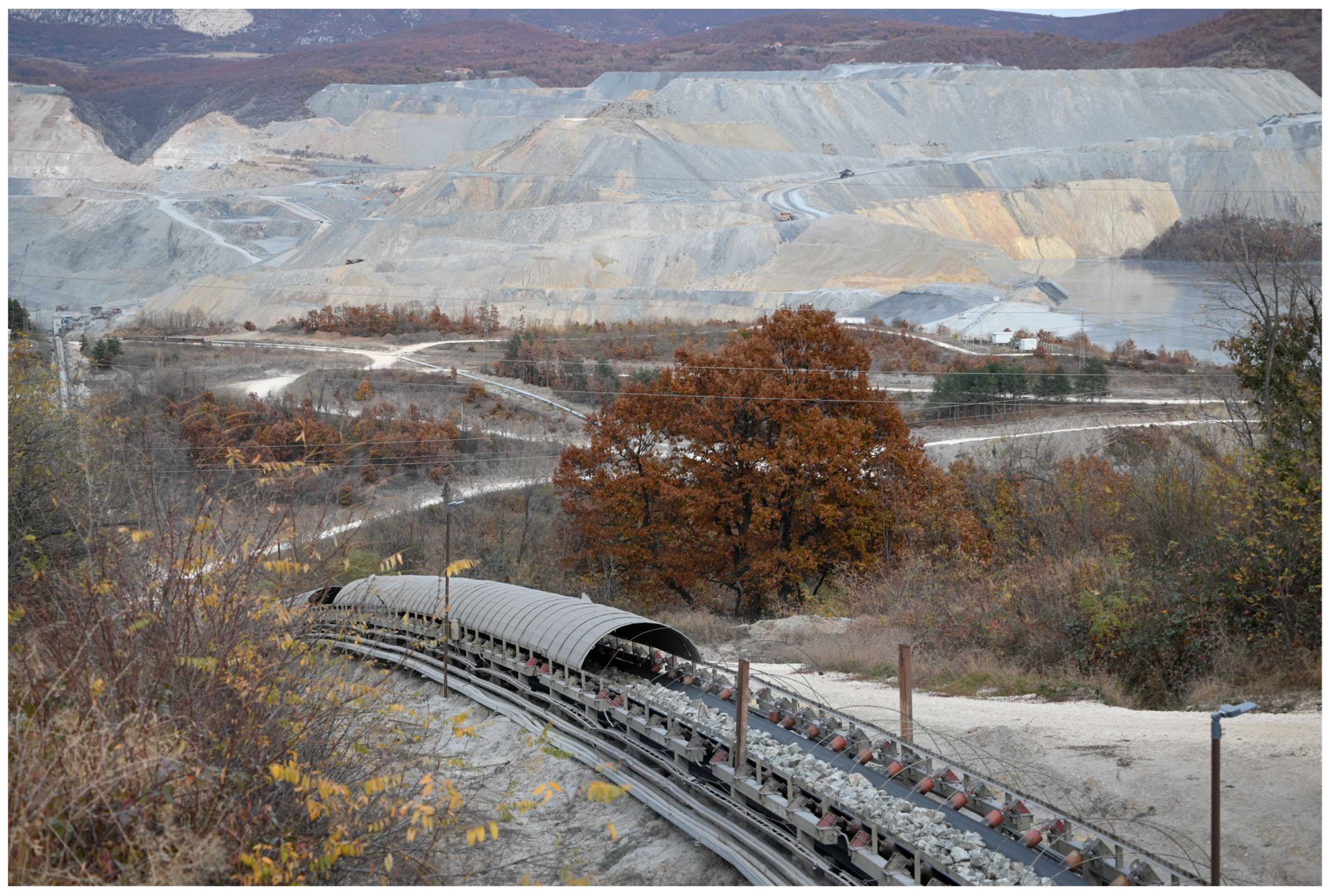
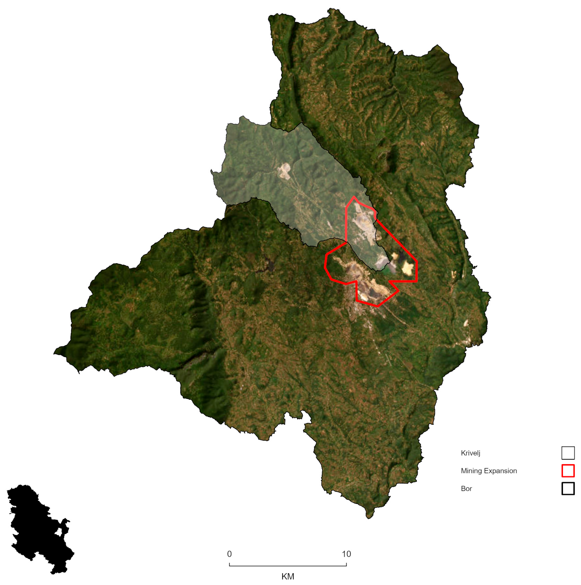
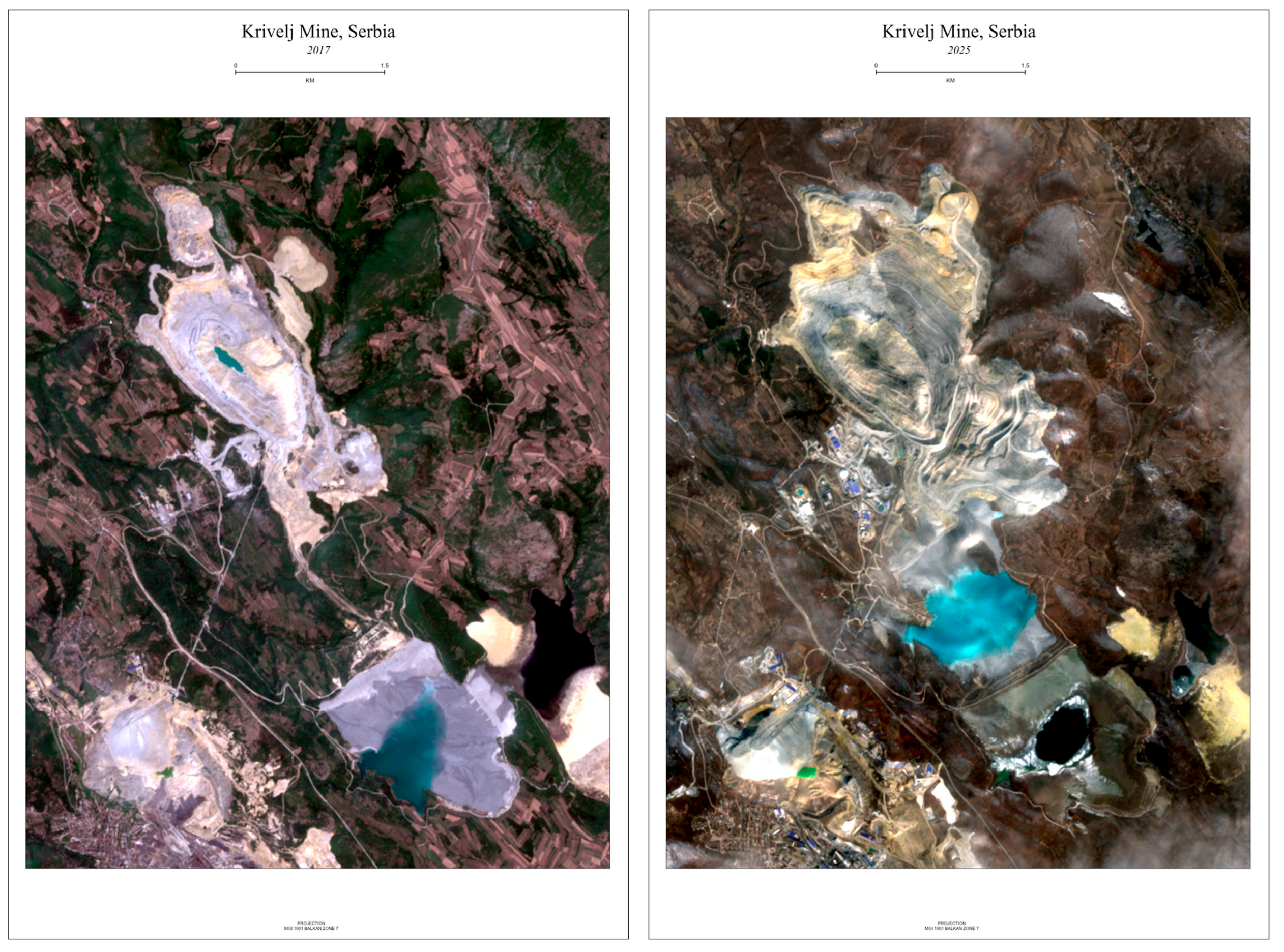
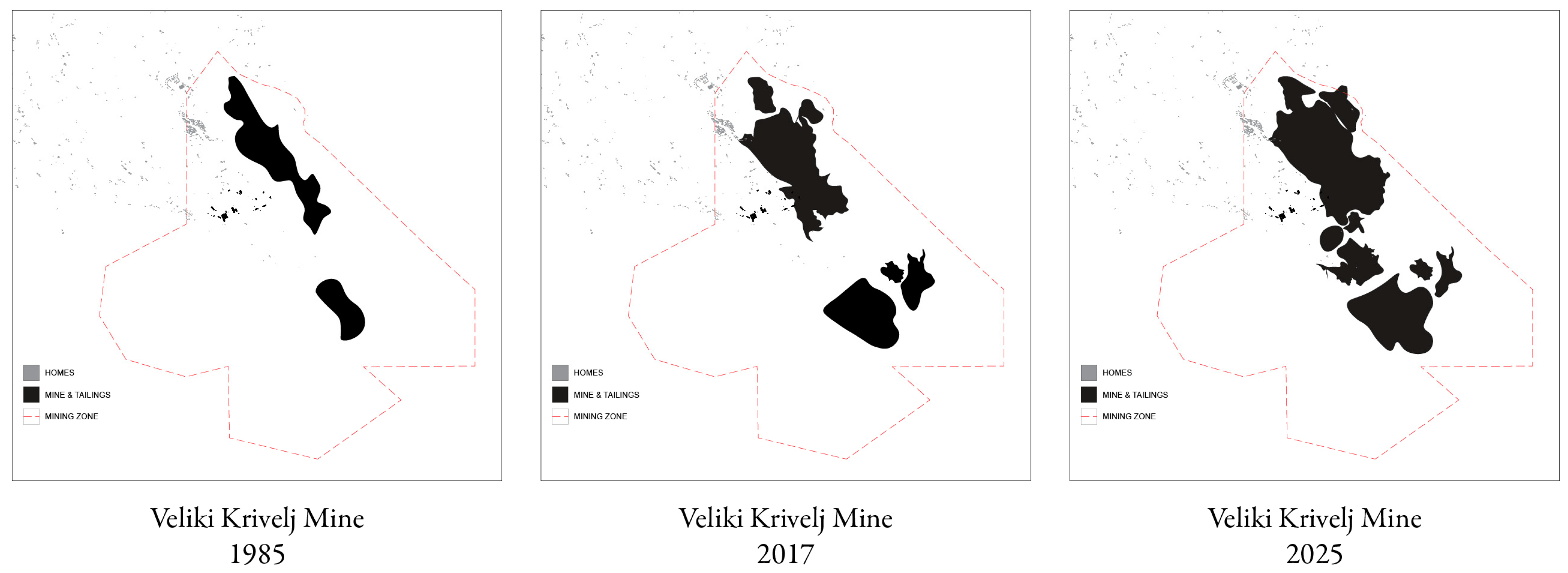
1.1. Krivelj at the Threshold of Global Extraction

In eastern Serbia, the village of Krivelj is caught in a geopolitical struggle for critical raw materials. Once a modest agrarian settlement resulting from Yugoslav socialist land reform, Krivelj is now facing intense spatial and epistemological changes. The catalyst is copper, a key material for the “green transition,” vital for electrification, battery production, and renewable energy infrastructure. While nations like the United States, the United Kingdom, and Germany acknowledge the necessity for copper and other critical raw materials (CRMs), which are essential for any climate solution and military technology and weapons, their extraction in Krivelj leads to severe ecological, social, and territorial damage. CRMs are natural resources that are economically and strategically important to the economy, but they also carry a high risk of supply disruption. They are essential for producing high-tech devices, renewable energy systems, electric vehicles, and defense equipment.
Following Serbia’s 2018 deal with China’s Zijin Mining Group, Mining and Smelting Basin Bor (RTB Bor), including the Veliki Krivelj mine, was integrated into a state-corporate model that reflects a global trend: the fusion of authoritarian governance, infrastructural finance, and extractive capitalism. The Zijin acquisition marks a shift in Serbia’s post-socialist trajectory from semi-sovereign resource management to what scholars term “resource extractive urbanism,” where geographies are reshaped to meet global demand [1,2].
Zijin’s activities in Krivelj have triggered unprecedented land expropriation, alterations to water systems, toxic waste discharge, and extensive resident displacement, characterized by minimal governmental oversight and a lack of meaningful community involvement. Following Zijin Mining’s takeover in 2018, copper production quadrupled, significantly amplifying environmental degradation, including soil contamination, polluted water supplies with hazardous substances such as lead, arsenic, and cadmium, pervasive dust pollution, continuous heavy truck traffic, and structural damage to residences due to mining vibrations [3]. As mining activities intensified, local agricultural practices became unsustainable due to toxic contamination, and residents experienced forced relocations and socio-spatial destabilization [4]. Academic studies further substantiate these conditions, documenting prolonged patterns of displacement, incomplete resettlement plans, and ongoing health and housing crises exacerbated by mining operations [5]. Consequently, Krivelj’s farmlands, homes, and cemeteries have been reclassified as industrial zones, severing deep-rooted community ties to the land. Residents have faced both physical and symbolic dislocation, losing territorial rights through legal and land-use changes. Thus, Krivelj exemplifies a sacrifice zone: politically marginalized, economically devalued, and environmentally compromised [6,7].

1.2. Problem Space: Critiquing Planetary Urbanization

Krivelj and similar sites offer critical case studies for contemporary urban theories, especially Planetary Urbanization (PU). Neil Brenner, Christian Schmid, and others argue that the PU theory posits that urbanization extends beyond city limits, encompassing infrastructure expansion, hinterlands, logistics networks, and global extractive sites [8,9]. While this viewpoint effectively frames urbanization as a metabolic process, it has faced criticism for oversimplifying spatial variations and neglecting the concrete realities that distinguish between space and place. Edward Said’s distinction between space and place emerges from his broader critique of imperialism. Space often refers to the abstract, decontextualized, and instrumentalized conception of geography used by imperial powers to control, chart, and dominate territories. It is associated with the colonial gaze, which views land as empty, available, or strategically valuable. Place, by contrast, refers to lived, historical, and culturally embedded environments—locations imbued with meaning, memory, and identity by the people who inhabit them [10]. In Krivelj, PU’s concepts fail to address the human scales of uneven development, the realities of dispossession, and local political nuances. Ananya Roy [11] notes that theories on planetary logics create a “God’s eye view,” ignoring the dispossessed’s knowledge. Keller Easterling [12] similarly warns that large-scale infrastructure analysis overlooks the complex and political aspects of spatial changes [13]. Thus, Krivelj is not just an empirical site but a theoretical challenge, exposing the limits of current urban theories and urging a focus on deeply situated, lived realities to understand planetary processes and new methodological strategies.

1.3. Counter-Cartographies as Methodological Intervention

This paper proposes a counter-cartographic methodology rooted in transdisciplinary research, defined here as an approach that dissolves traditional disciplinary boundaries to generate hybrid methods extending beyond the constraints of individual fields. Unlike multidisciplinary research, which maintains clear distinctions between disciplines, this transdisciplinary inquiry fosters continuous, entangled, and relational analyses across domains to reveal the transcalar transformations in Krivelj driven by resource extraction. Inspired by Cindi Katz’s countertopography, which connects places through shared global restructuring experiences, this approach blends geospatial techniques with ethnographic fieldwork and architecture to expose the frictions of extractive modernity [14]. It also incorporates Jane Hutton’s reciprocal landscapes concept, arguing that spatial design and environmental exploitation should be examined as intertwined processes [15,16].
Methodologically, the paper mobilizes three epistemic domains:
  • Geomatics offers tools for territorial analysis via satellite imagery, GIS mapping, and environmental modeling;
  • Ethnographic fieldwork reveals the emotional and historical aspects of displacement [17] via oral histories, sensory ethnography, and participatory mapping;
  • Architecture deciphers legal frameworks that make extraction possible and inevitable, viewing spatial plans and built forms as ideological tools.
This triangulated methodology ignores disciplinary silos; instead, it views them as deeply entangled fields, which, when they productively collide, can expose the multitude of perspectives on and of the same phenomenon. Collectively, they form a transscalar lens: shifting from planetary systems to village pathways, from copper flows to familial memories, and from aerial topographies to bodily sensations (Figure 1).

1.4. Situating the Research: From Local Narratives to Global Assemblages

This paper argues that places like Krivelj are not peripheral. Instead, they are central figures in global networks, providing the raw materials that support sustainable urbanism in Berlin, electric car production in Shanghai, and wind turbine design in California. However, the forces needed to sustain these green utopias are rarely acknowledged in global discourse. This research positions Krivelj not merely as a passive recipient of external forces but as an active site of knowledge production, resistance, and alternative imaginings. It sees villagers not as victims, but as narrators, activists, and analysts of their situated geographies. The goal is not only to diagnose spatial injustice, but also to offer alternative spatial practices that challenge the inevitability of extraction, taking into account the heated situation regarding mining and the opening of new locations in Serbia [18]. The project creates “new” counter-cartographies, each concentrating on a distinct spatial reality of Krivelj’s transformation: ecological, symbolic, labor, and institutional. These maps find a balance between technical precision and personal narratives. They serve as tools for both visualization and dissent, interrogating who has the authority to represent space and for what purposes.

1.5. Research Questions and Objectives

Three main questions structure this research:
  • How do transscalar extraction processes, from global supply chains to bodily exposures, manifest in the spatial reorganization of Krivelj?
  • What knowledge and tools are needed to map these transformations without reproducing the forces of abstraction?
  • How can transdisciplinary methods enable rigorous, flexible, and collaborative counter-cartographies?
By addressing these questions, this paper contributes not only to urban theory [19] and critical geography but also to discussions on architecture, post-socialist studies, and environmental humanities. It challenges dominant spatial theories and provides a transcalar methodology for a more focused, situated, and spatial engagement with the processes and scales of extraction.

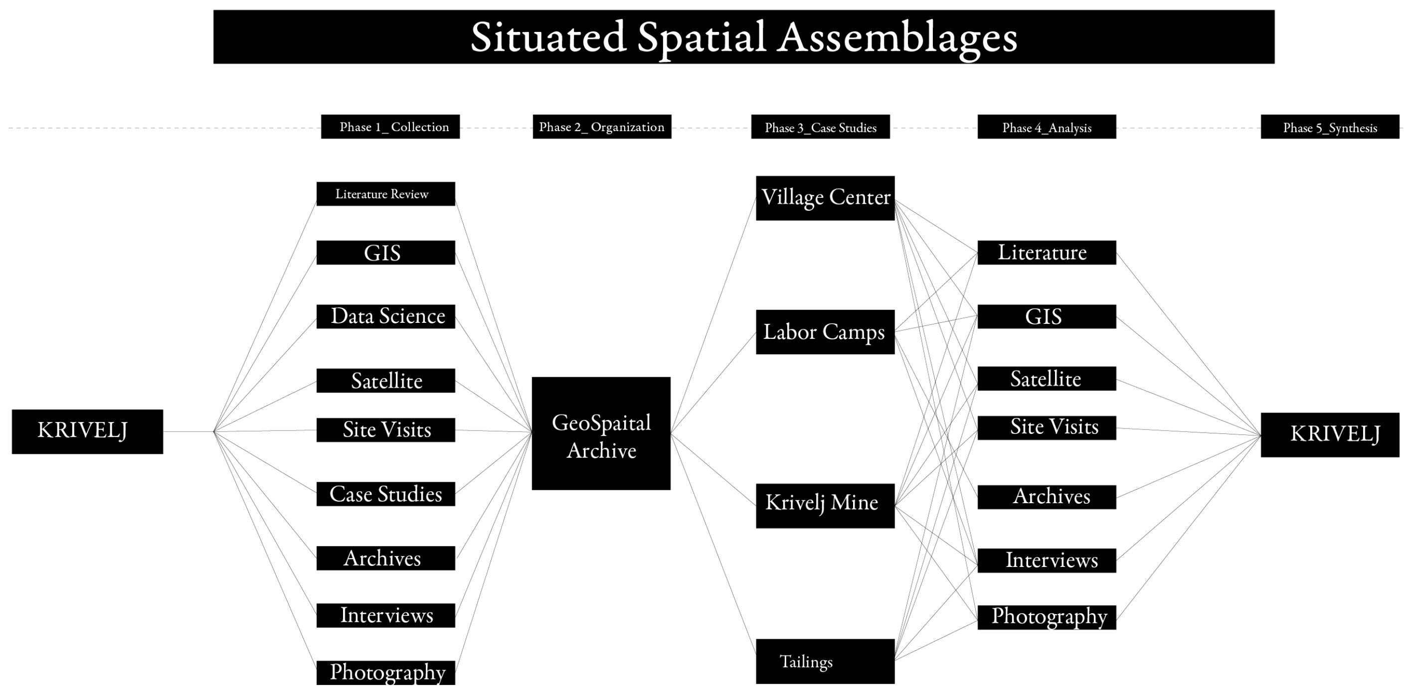
2. Materials and Methods

2.1. The Research Orientation: Why a Transdisciplinary Approach?

To understand Krivelj’s transformation under extractive pressures (Figure 2), this research employs a genuinely transdisciplinary methodology that explicitly integrates anthropology, geomatics, and architecture. Each discipline offers distinct yet complementary perspectives on space: anthropology emphasizes lived experiences, embodied memories, and community narratives; geomatics provides precise spatial measurements and environmental insights; and architecture critically analyzes the design logics and institutional frameworks of territorial governance.
This approach actively synthesizes different ontologies of space—lived, measured, and governed—into a cohesive, integrated framework for comprehensive analysis and illustration (Figure 3). Drawing upon Cindi Katz’s [14] methodological imperative to engage with “the relational, the intimate, and the scalar,” this research adopts an anti-disciplinary stance, explicitly challenging the abstraction inherent in technocratic representations of infrastructure and resource extraction. By doing so, it foregrounds relational and embodied spatial experiences, making visible the intricate interconnections between global processes and local impacts.
The methodological structure of this research is grounded in Paasi’s (1998) triadic model of territoriality, which delineates three interconnected dimensions of space: material, symbolic, and institutional [20]. The material dimension focuses on tangible, physical landscapes and environmental changes, captured through GIS layers and geomatic analysis [21]. The symbolic dimension highlights the meanings, memories, and identities embedded within spaces, which are explored through ethnographic methods such as oral histories and walking interviews. The institutional dimension investigates how governance structures, policy frameworks, and architectural interventions shape and regulate space, analyzed through institutional documents and architectural plans [7]. Employing Paasi’s framework explicitly ensures that empirical data, whether derived from precise spatial measurements or intimate personal narratives, is critically interpreted within these interconnected dimensions, thus offering a comprehensive and situated understanding of Krivelj’s transformation.

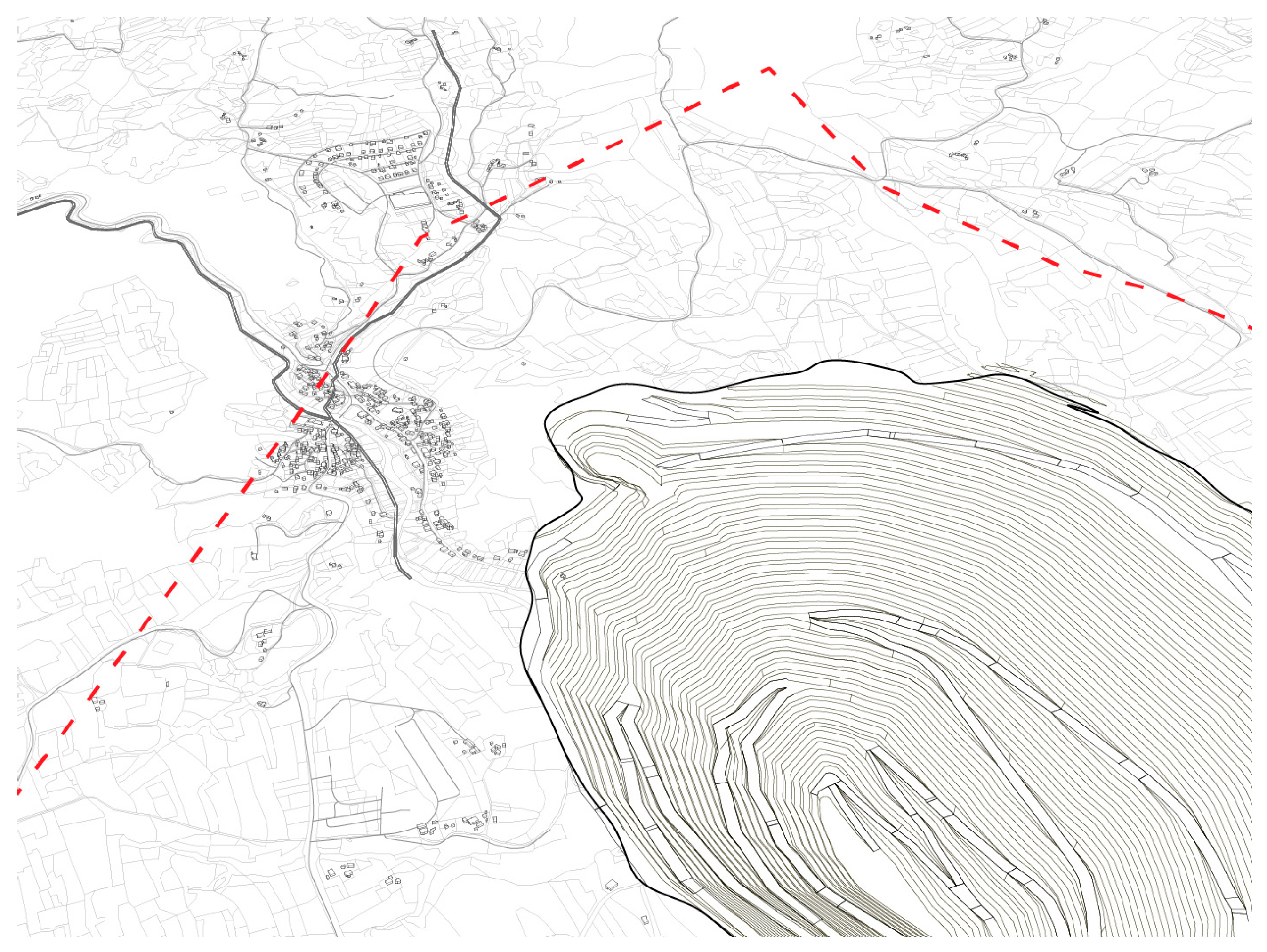
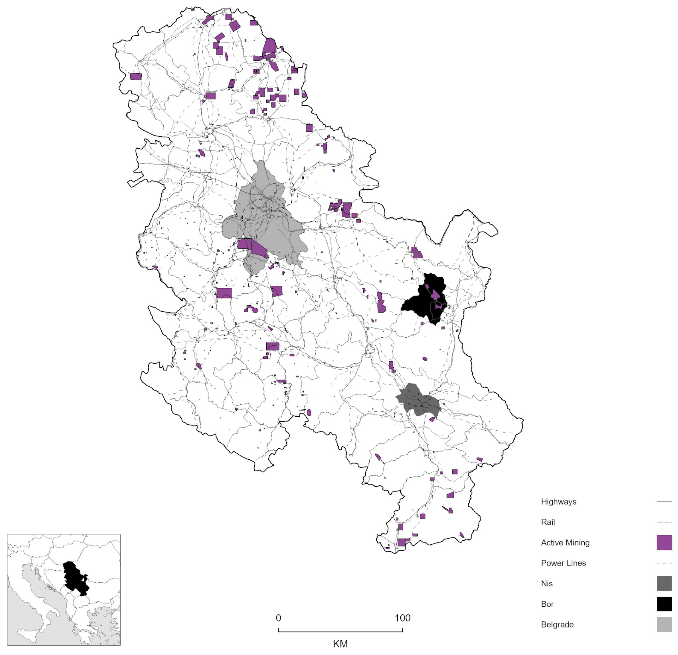
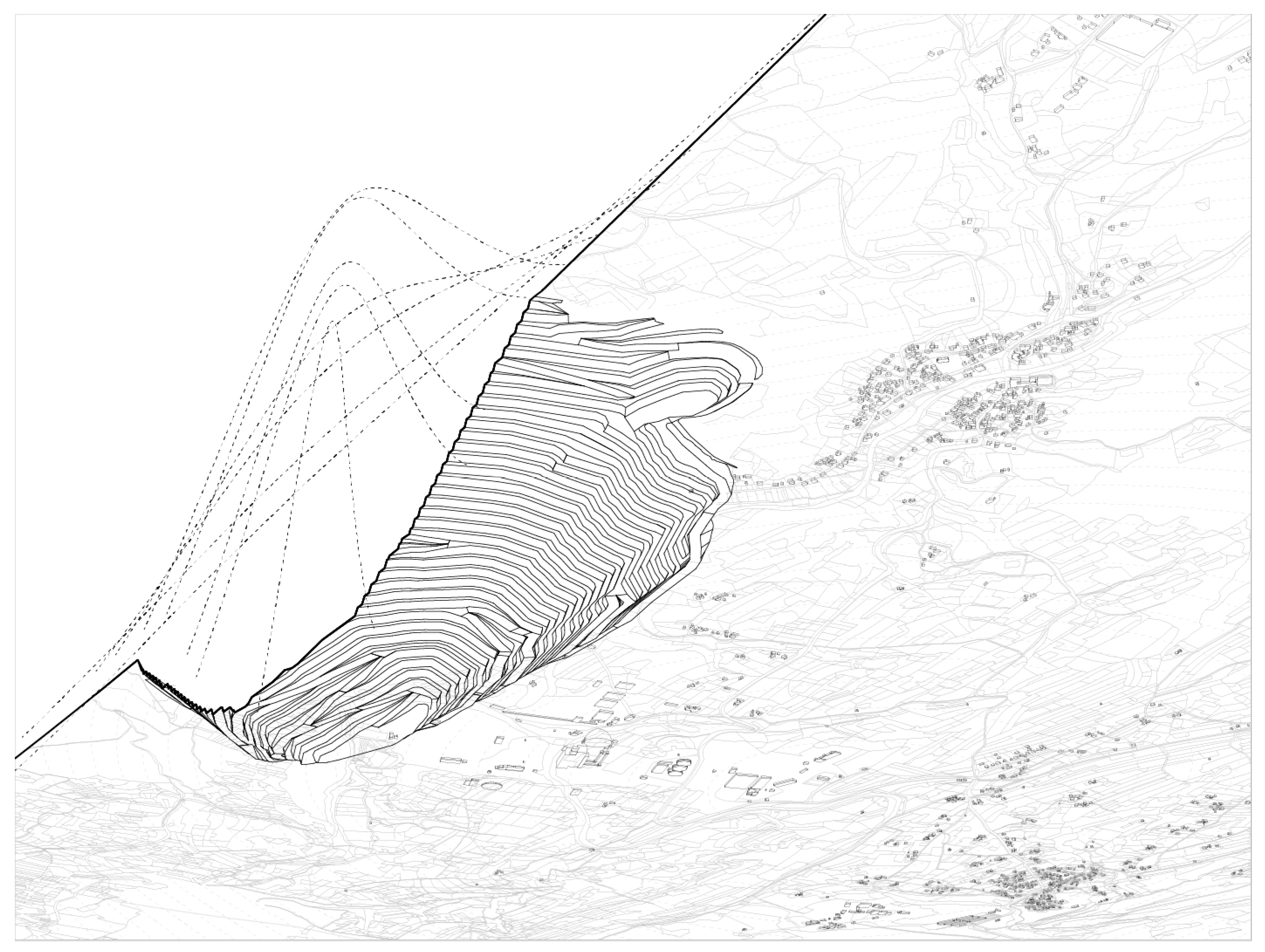
2.2. The Research Site: Krivelj as a Territorial Laboratory

Krivelj, situated approximately 150 km southeast of Belgrade in the Timok Mountains of eastern Serbia, boasts a rich and complex identity (Figure 4 and Figure 5). There are no official records documenting its founding; however, many current residents trace their roots back to Romanian immigrants who settled in the area after Romania gained independence from the Ottomans in 1878. These early settlers primarily engaged in agriculture, shaping the village’s initial character. This historical migration is responsible for the region’s unique dialect, a blend of Serbian and Romanian. The discovery of copper deposits in nearby Bor during the 20th century transformed the area into a thriving mining center. In 1947, as part of socialist Yugoslavia, mining was nationalized with the establishment of RTB Bor, resulting in significant infrastructural developments that connected villages like Krivelj to the growing industrial sector. Although this era brought economic growth, it also created persistent environmental and social issues that continue to affect the community today. Krivelj’s identity underwent a notable transformation in 1960 with the finding of substantial copper ore deposits [22]. Since then, mining has been a central part of the village’s identity. Plans for relocating residents to make way for copper mining were first proposed in 1973 and again in 1997, when the government suggested moving the entire village to maintain community cohesion and cultural identity. However, these plans were never realized.
With the dissolution of Yugoslavia in the 1990s, Serbia amended its constitution in 1995, legalizing the sale of land previously owned by municipalities to private investors [23,24]. In 2015, Serbia enacted the Law on Investment, which ensured equal treatment for domestic and foreign investors and established a framework for investment incentives, including access to land for development. This effectively opened the Serbian land market to foreign investors with minimal restrictions, including land designated for mining [25].
During the 2010s, China’s Belt and Road Initiative (BRI) identified Serbia as a partner for infrastructure investment (a global infrastructure and investment strategy led by China), which has catalyzed large-scale resource extraction in developing countries like Serbia, often at the expense of local communities and environments. On 17 September 2018, Zijin Mining Group entered into a partnership with the Republic of Serbia to acquire the Mining and Smelting Basin Bor (RTB Bor), which encompasses the Veliki Krivelj mine. In December 2018, Serbia Zijin Copper—a joint venture owned 63 percent by Zijin (Europe) International Mining Company Limited and 37 percent by Serbia—officially took control of RTB Bor. This acquisition was supported by a USD 1.26 billion business plan, which included a USD 350 million capital injection and a commitment to cover USD 200 million of RTB Bor’s outstanding debts. [26,27]. Although Serbia holds a minority stake, the government portrayed the agreement as a triumph, highlighting the benefits of foreign investment while minimizing concerns about sovereignty and environmental repercussions.
Zijin entered Serbia after years of failed attempts to restructure RTB Bor. The acquisition was anticipated before 2018, influenced by political rhetoric. In 2016, then-Prime Minister Aleksandar Vučić stated that he would kneel before Premier Li Keqiang to secure Chinese investment in RTB Bor [28]. By 2017, he escalated his claims, suggesting he would jump into the Sava or Danube rivers to celebrate a successful deal [28]. This political narrative depicted China as Serbia’s economic savior, enabling the ruling Serbian Progressive Party to support Zijin’s role despite the risks of foreign control over national resources. Critics argue that the government’s portrayal of the deal as a rescue papered over significant concerns about environmental degradation, labor conditions, and Serbia’s increasing economic reliance on China [26].
Under Zijin’s ownership, mining activities have quadrupled since 2017 [29]. Krivelj’s annual copper production increased from 43,550 metric tons in 2019 to 100,000 metric tons in 2023. This operational intensification has worsened air pollution and caused structural damage, resulting in a two-thirds decrease in the number of schoolchildren as families relocated [27]. Zijin’s planned expansion of the Krivelj mine requires relocating the entire village of 1300 homes and expropriating the land of its residents. In February 2022, the Ministry of Mining and Energy approved the relocation, but Zijin has pursued a piecemeal land acquisition strategy to avoid full responsibility. Locals report poor communication from the company, hindered by disorganization. Resident and activist Jasna Tomić criticizes Zijin’s approach as divisive, as it isolates those resisting displacement by purchasing properties individually instead of facilitating collective relocation. Tomić noted that this strategy creates a “domino effect,” pressuring holdouts as social and economic systems collapse. The fragmentation affects more than just physical displacement; it disrupts family, community ties, and connections to the land [30]. While the Serbian government, which holds a 37 percent stake in Serbia Zijin Copper, supports the mine expansion, it has not addressed Zijin’s mishandling of Krivelj’s relocation, leaving many residents uncertain.
The absence of dependable spatial data or the difficulty in obtaining it has hindered activists in their efforts to support the Krivelj relocation effectively, considering the importance of participation and transparency in such processes [31]. Although spatial plans are required, the current documents prioritize corporate growth over ensuring public accountability. Trkulja maintains that Serbia’s planning reforms, designed to modernize governance, have empowered investors more than municipalities, allowing foreign companies like Zijin to circumvent local regulations [32]. The Serbian government’s emphasis on foreign direct investment has diminished the effectiveness of public participation measures, with hearings often held at inconvenient times or seen as mere formalities. Tomić highlights that spatial planning, intended to be public, disproportionately benefits those with financial means, leaving residents with limited options to challenge corporate actions [30]. The diminishing state oversight and public involvement have enabled Zijin’s unchecked growth, further entrenching investor-led urbanization in Serbia.

2.3. Theoretical Framework and Methodological Structure

These frameworks facilitate the integration of disciplines, tools, and spatial scales to create a matrix structure that analyzes Krivelj through overlapping data types, such as remote sensing, field narratives, participatory maps, and bureaucratic documents. The research framework is centered around three interconnected concepts:
  • Territorial Restructuring: Building on Stuart Elden’s reconceptualization of territory as a form of political technology [33], this research explores how territory is created through planning, force, and abstraction.
  • Forensic Spatial Analysis: Drawing on Eyal Weizman’s work with Forensic Architecture, this research employs mapping not as a neutral representation but as a counter-investigative practice that reveals hidden or denied spatial histories [7].
  • Reciprocal Landscape: Jane Hutton’s concept of reciprocal landscapes reframes the project’s cartographic focus [15]. Maps should track extraction sites and illustrate connections to consumption nodes, infrastructures, and political centers beyond the region [34].

2.4. Methodological Contributions by Discipline

Geomatics, as territorial analysis through geospatial technologies, was used to visualize the morphology of the material landscape, particularly in areas affected by mining expansion. By depicting terrain deformation, vegetation decline, and industrial encroachment, geomatics not only clarified the true sites of extraction but also provided a platform for counter-visualization based on empirically validated environmental critique. The tools and techniques included the following:
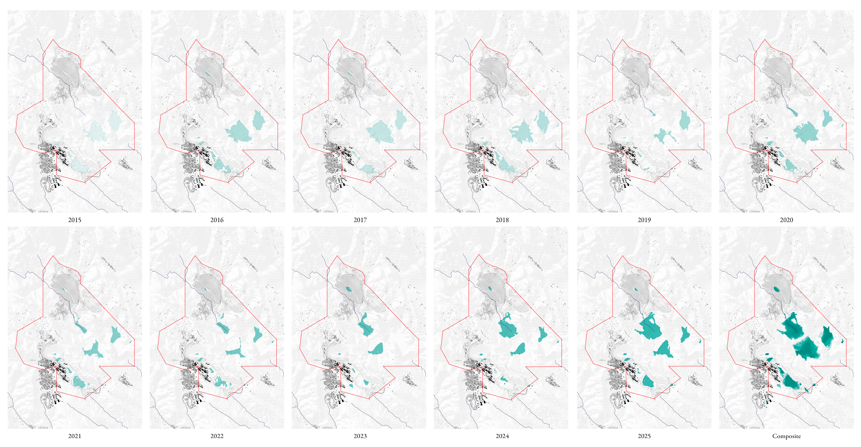
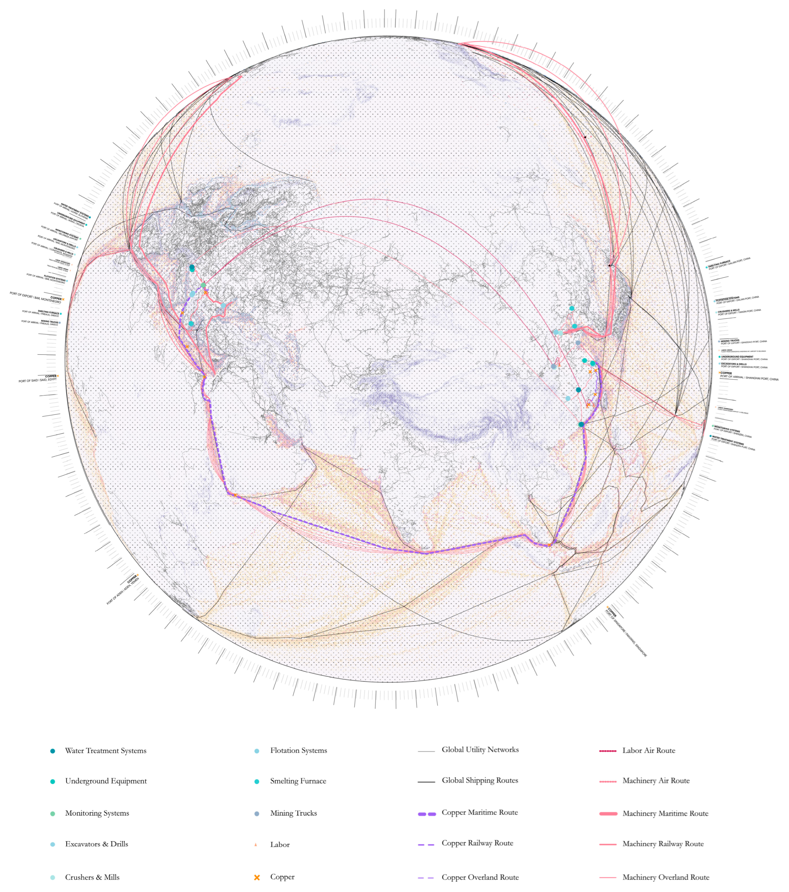
  • Satellite Remote Sensing: Analyzing Landsat and Sentinel-2 imagery revealed land cover changes, assessed vegetation loss, and tracked hydrological rerouting. NDVI analysis showed a decline in biomass near the tailing expansions.
  • Environmental Modeling: measuring and modeling air, water, and noise pollution as a result of mining and the expansion of the mine.
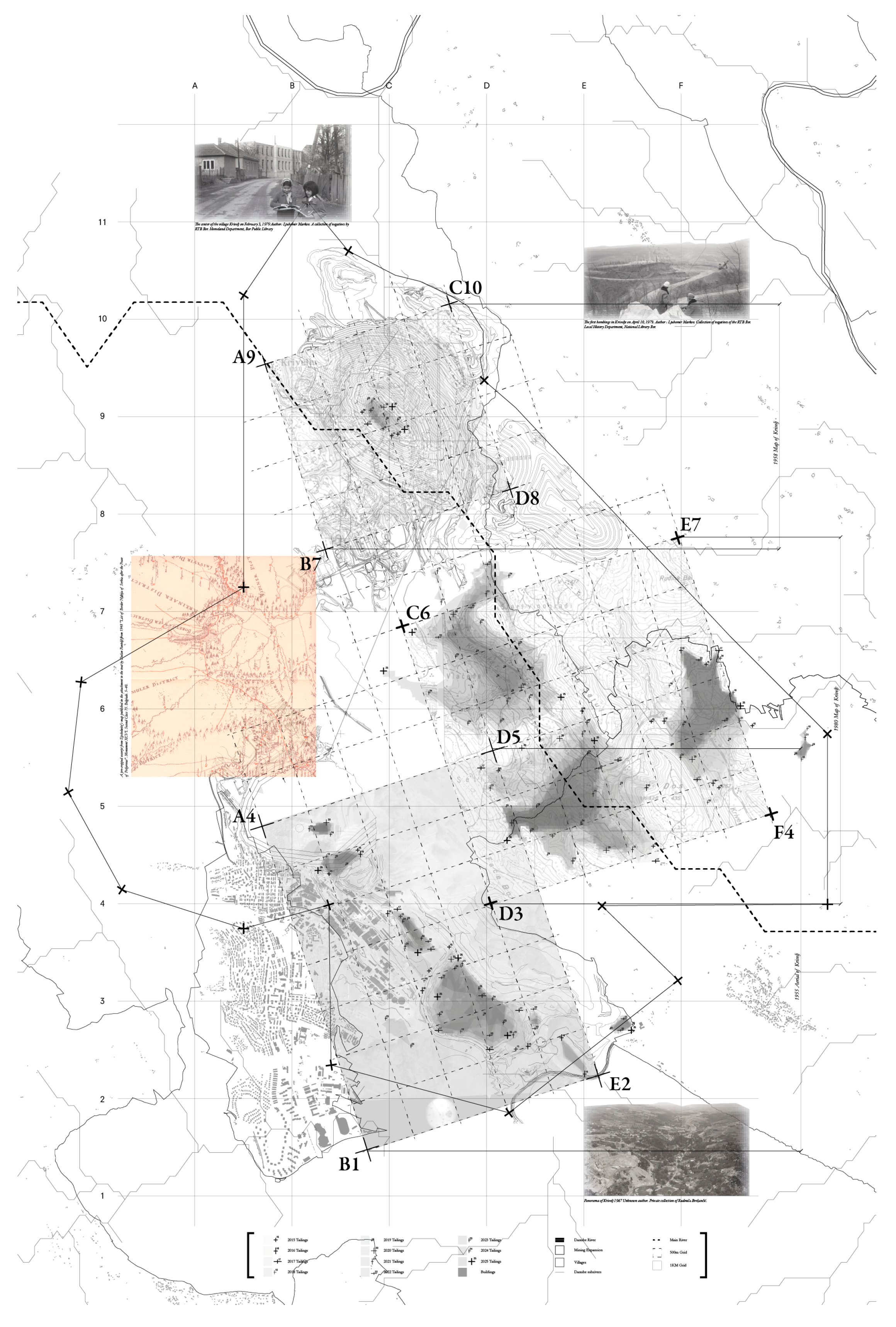
  • Georeferencing Participatory Data: Residents’ memory maps from the workshop are overlaid on official cadastral basemaps, revealing spatial gaps between official and lived geographies.
  • Software and Datasets: ArcGIS Pro and Rhino were the main tools, with data from Copernicus, NASA EarthData, and the Serbian Geodetic Authority.
Anthropological methods, such as oral histories, spatial memory, and sensory geographies, were used to capture the subjective experience of transformation, specifically how bodies, senses, and histories register extraction in ways that satellite or zoning data cannot:
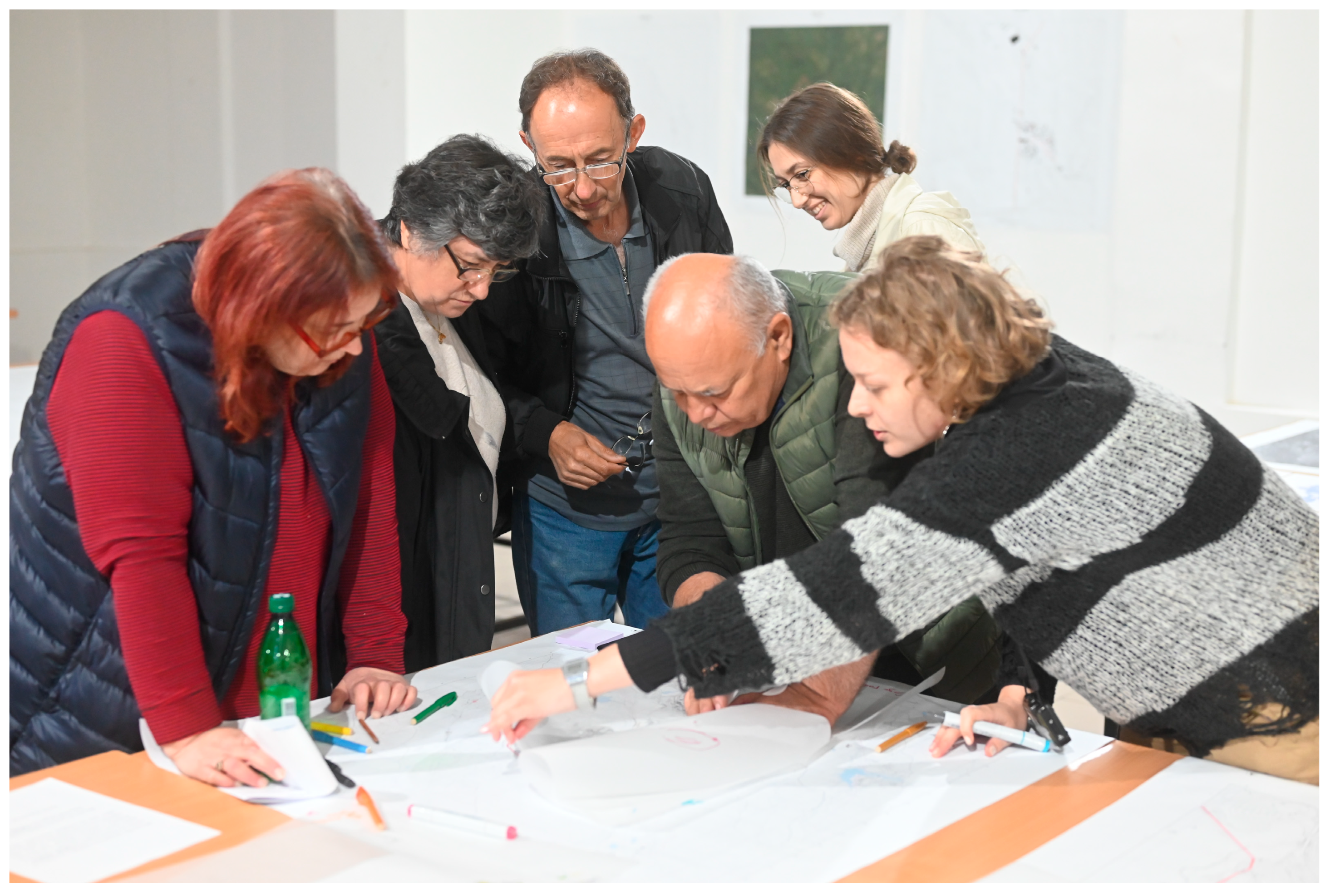
  • Semi-Structured Interviews: Conducted with twelve residents, mostly displaced or at risk, focusing on place attachment, memory, health, and spatial practices pre- and post-mine expansion.
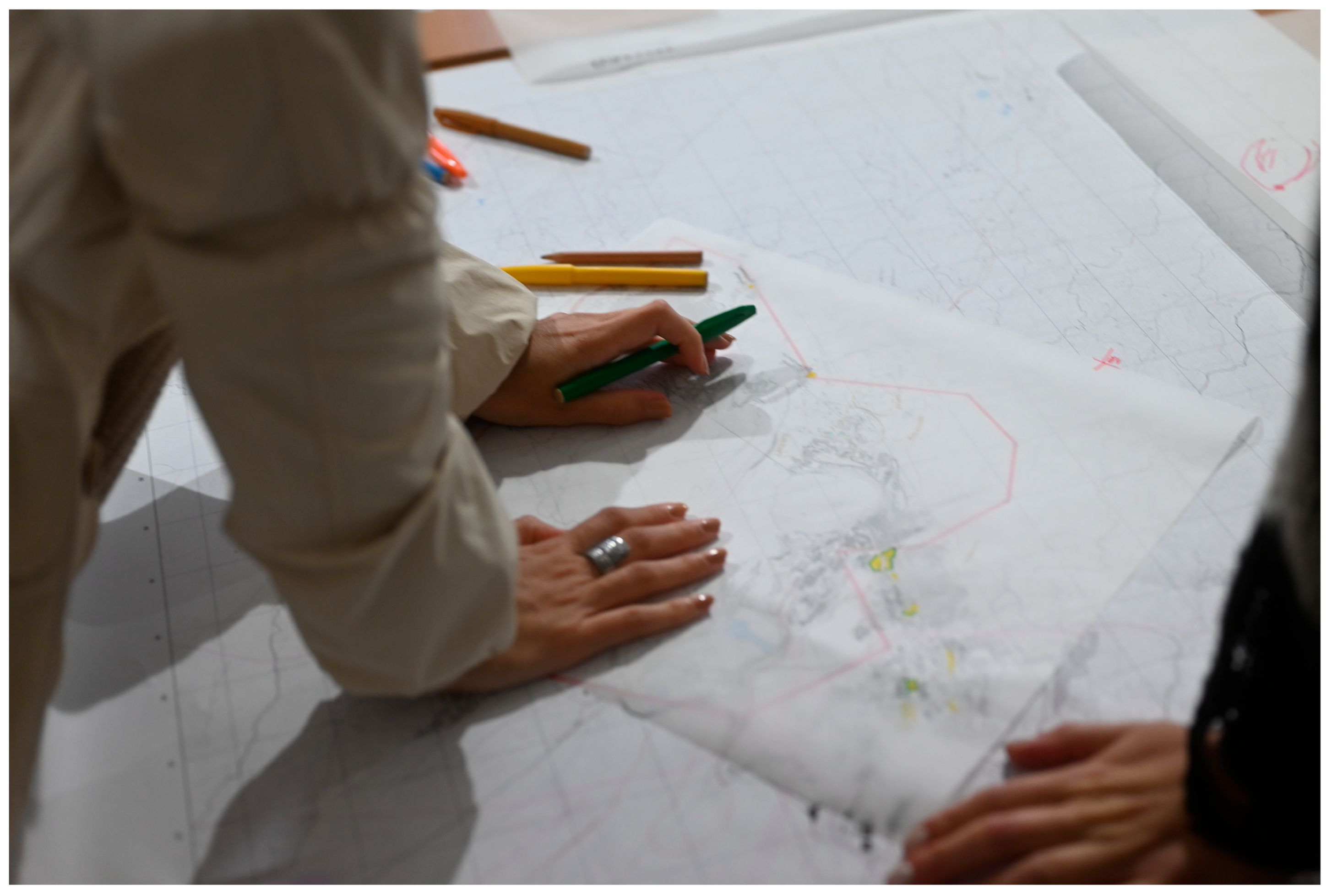
  • Personal Sketching: Interviewees illustrated their memories of Krivelj “before the mine.” These sketches evolved into intuitive maps that expressed personal geographies and localized epistemologies of space. Intuitive mapping challenges the Cartesian, objective, and colonial logics of conventional cartography by foregrounding affective, embodied, and subjective spatial experiences. Drawing from critical theory, psychoanalysis, and feminist geography, this methodology sees maps not merely as representational tools but as instruments for exposing and subverting hegemonic spatial orders.
  • Positional Awareness: Documented spatial and ethical tensions, especially when community suspicions about academic visitors intersected with trauma and grief.
Architecture, urban, and spatial planning, in the sense of institutional design and territorial governance, is deployed as a methodology that examines the institutional structures and spatial tools that render extraction legal, comprehensible, and enforceable. By interpreting architecture as a state-corporate language, this research method reveals the planning fictions and legal evasions that enable the persistence of extraction under the guise of modernization and progress:
  • Spatial Plan Analysis: Reviewed spatial planning documents to integrate extraction with regional development goals while examining any potential contradictions with reality.
  • Cadastral Review: Property titles and land classifications were examined via Serbia’s e-Cadastre. The people on the land still own areas labeled as owned by Zijin in the Planning reports.
  • Design Reading: Analyzed urban planning and relocation for housing, villages, and worker camps using architectural methods. Key questions included the following: What life is envisioned by these spaces? Who do they aim to exclude?

2.5. Participatory Counter-Mapping and Reflexive Practices

The project’s key innovation was counter-cartography, developed in collaboration with community members and enhanced with remote sensing and cadastral data. This participatory model was essential not only for ethical reasons but also as an epistemological stance: it acknowledged that expertise resides in lived experience and that marginalized spatial knowledge must be represented cartographically to carry political weight. This process involved three phases:
  • Mapping Workshops: Residents illustrated memory-based spatial features, such as vanished orchards, community gathering spots, and burial sites (Figure 6).
  • GIS Integration: The drawings were digitized, georeferenced, and integrated with GIS layers displaying zoning changes, mining concessions, and tailings expansion.
  • Map Narration: Residents annotated digital maps with stories, warnings, or critiques, turning them into spatial testimonies (Figure 7).

2.6. Integration and Synthesis

Data integration employed technical platforms, such as ArcGIS Online and NVivo, for qualitative data coding, complemented by Paasi’s triad conceptual matrices [20]. Each field insight was categorized based on its relevance to material, symbolic, or institutional territoriality. This allowed for comparisons between satellite-based hydrological changes and interview narratives about river loss. Ethical rigor was maintained through member checking, informed consent, and the anonymization of visual data. If participants chose to be identified as an act of resistance, their full names were used with their consent.

3. Results

Satellite imagery, GIS mapping, and field observations highlight the ecological impacts of copper extraction, demonstrating the scale and intensity of resource extraction. A significant change is the rerouting of the Krivelj River by Zijin for mining expansion. Residents reported in interviews that the new water tunnel failed during the 2020 flood, causing substantial damage to agriculture and infrastructure. In a December 2024 interview, Milos Božić said, “The river is no longer ours. It has been moved, controlled, and turned into something unnatural. Nevertheless, nature pushed back, and we lost everything during the flood (Figure 8) [35,36].” Mapping the flooded areas reveals the extensive impact of industrial activities, highlighting how local communities often face environmental risks that are frequently overlooked in discussions of global urbanization. A significant aspect of Krivelj’s landscape is the proliferation of tailing ponds. Satellite imagery reveals their expansion, with toxic byproducts from copper processing persisting over the last decade. Satellite and GIS water flow overlays illustrate pollutant infiltration into nearby rivers and aquifers, linking Krivelj’s environmental issues to larger ecological systems that extend to the Danube River and the Black Sea. These maps highlight the cross-boundary damage from extraction activities (Figure 9). Tomić calls the tailing ponds “poisonous lakes that grow closer to our homes yearly [30].” Mapping reveals that homes currently on the market lie within the expanding mine area, complicating visual narratives that depict extraction zones as uninhabited or solely functional.

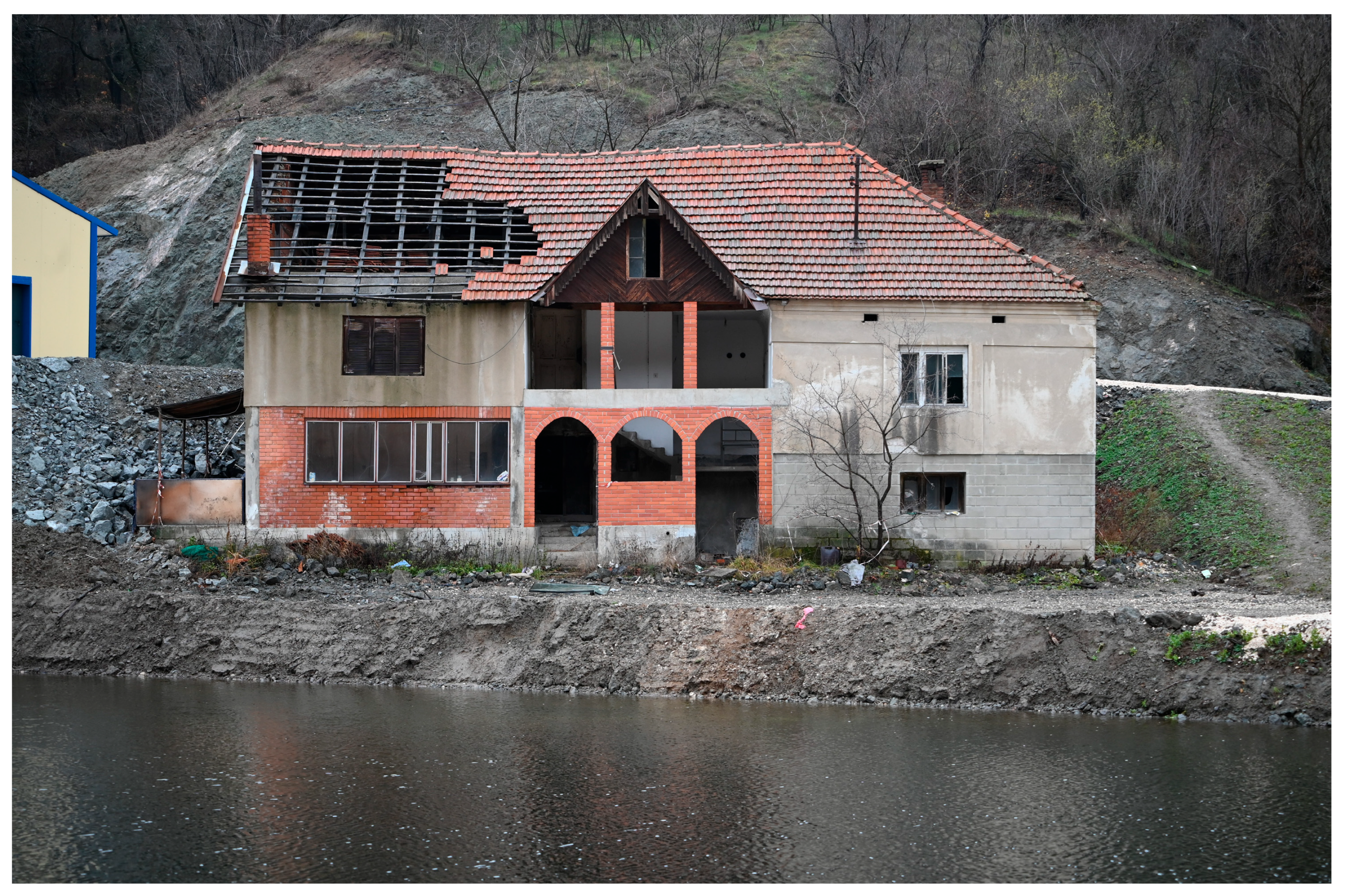
3.1. Social Entanglements: Mapping Fragmented Relocation

Examining changes in Krivelj’s population reveals community fragmentation due to expanding mining activities. Integrating property records, resident interviews, and satellite imagery illustrates the sale of homes and farmlands, which leads to clusters of abandoned properties amid industrial growth. This situation creates a “domino effect,” as Tomić notes, increasing pressure on remaining residents to sell and hastening the community’s decline. Tomić states the following: “Our village is disappearing house by house. They [Zijin] do not move us together—they break us apart, one family at a time [30].” This mapping highlights the strategic nature of gradual displacement. Examining historical maps of Krivelj alongside current mining operations highlights the destruction of vital cultural sites. Cemeteries, churches, and family homesteads have been demolished or rendered inaccessible due to the mine’s expansion (Figure 10). For many locals, these areas symbolize deep generational connections to the land that compensation cannot replace. Conversations with elders reveal their strong bonds with Krivelj’s hills, forests, and landmarks, now scarred by extraction. Božić mourns, “The hills I climbed as a boy have been swallowed by machines. Even the graves of our ancestors are no longer safe [35].”

3.2. Labor Entanglements: Mapping Economic Dependency and Precarity

Krivelj’s role in copper mining highlights economic dependence and unstable labor conditions. Examining labor flows reveals contradictions in resource-driven urban growth: local communities support global networks while remaining marginalized. This study includes qualitative field research conducted from March 2022 to February 2025, based on informal interviews with more than twenty Serbian Zijin employees, predominantly conducted in informal settings such as cafés and bars in Krivelj. While these conversations did not follow a strict structured interview protocol, respondents independently raised consistent concerns regarding precarious employment practices, highlighting informal contracts, limited job security, and inadequate safety measures. These qualitative insights were supported by structured interviews with academic experts from Bor and senior managers from Zijin, which strengthened the evidence that precarious labor conditions are perceived as prevalent among the village’s male working-age population. However, due to the informal nature of these interviews, further quantitative research would be beneficial to validate these claims. Mapping labor routes to Bor’s smelting and processing plants illustrates how copper extraction fuels local and regional economies while threatening social structures. Dependence on Zijin creates economic pressures that inhibit some residents’ resistance, while others demand relocation and environmental accountability. Tomić reflects on the struggle: “We are forced to work for the company destroying our village. If we refuse, we will starve. If we accept, we will lose our land [30].” Labor maps reveal the connections between local workers, industrial activities, and global copper supply chains, exposing these contradictions.

3.3. Mapping as a Counter-Narrative: Revealing Entangled Geographies

The mapping of Krivelj’s environmental, social, and labor intricacies challenges the simplistic view of extraction zones presented by Planetary Urbanization. By integrating these maps with oral histories and field observations, this project aims to foster a deeper understanding of urbanization that acknowledges its contradictions while amplifying the voices of those most affected. Mapping Krivelj through Katz’s countertopography prompts us to rethink extraction landscapes as arenas of struggle, resistance, and potential rather than mere points within planetary systems. Traditional cartographic practices have historically aligned with power structures, reinforcing dominant narratives that overlook local complexities [37]. In response, critical mapping practices have emerged as counter-narratives, reclaiming cartography for resistance, critique, and emancipation. Katz describes countertopography as a research methodology that links geographically distant yet structurally connected places through planetary processes. Countertopography emphasizes contextual realities [14] and seeks to depict the uneven nature of global capitalism without oversimplifying localized experiences. It aims to illuminate the relationships between “here” and “there”—for example, the connection between a copper mine in Krivelj, Serbia, and the skyscrapers in global metropolitan centers that rely on this extraction. Katz defines countertopography as mapping a “topography of common struggles” [14], illustrating how the uneven evolution of global capitalism fosters connections and distinctions. In Krivelj’s context, countertopography uncovers how the global demand for copper, driven by modern capitalism, creates social and environmental vulnerabilities that remain hidden. For instance, clean energy infrastructure presents a dilemma: while copper is essential for renewable technologies like wind turbines and solar panels, its extraction causes significant ecological harm. Although mainstream urban theories, such as PU, critique global infrastructures, they often overlook ecological devastation at local levels. Countertopography reveals these contradictions, highlighting the “outside” of PU’s framework—dimensions of extraction and marginalization that are crucial to the global system but are neglected in its analysis.

3.4. Visual and Cartographic Methods for New Spatial Plans

Historically, cartography has served as a tool for control, facilitating state, colonial, and capitalist objectives by simplifying complex landscapes into manageable abstractions to support economic exploitation [38]. In Serbia, this is illustrated by spatial plans, documents mandated for mining companies to promote site development. These plans detail land use, development priorities, and environmental protections, which are essential for urban planning and ecological management, as required by national laws [39]. Only certified spatial planners are permitted to create these documents and must adhere to established legal processes [39]. However, discussions with spatial planners indicate that current guidelines are outdated and can be easily exploited by private companies, such as Zijin, which commissions these plans [34]. Corporate-driven spatial planning often overlooks the significant effects it has on villages, rivers, and cultural landmarks in the Bor region, such as Krivelj, which are treated as obstacles, diminishing their significance. This fosters a narrative of disposability, where communities and ecosystems are subordinated to extractive economies under the pretense of legal compliance [40]. If spatial planning frameworks are not reassessed and public oversight increased, these plans will continue to cause territorial erasure and environmental degradation for private interests. Spatial planning strategies must consider temporal factors, recognizing how historical events influence current challenges and future urban developments. By charting the human, ecological, and historical aspects of a location, planners can learn from past mistakes and enhance their adaptability. GIS mapping illustrates environmental transformations, particularly those resulting from mining operations, by overlaying historical and contemporary satellite images of Krivelj:
  • Mining infrastructure development: Between 2017 (Figure 11) and 2025 (Figure 11), the Veliki Krivelj copper mine expanded 50% (Figure 12), adding tailing ponds and smelting facilities.
  • Hydrological disturbances: Redirection of the Krivelj River affects downstream flooding and soil erosion.
  • Toxic flows: Mapping pollutant distribution from tailing ponds to rivers and aquifers shows the link between local ecological crises and broader environmental systems, challenging the notion of isolated extraction areas.

3.5. Synthesis and Findings

The countertopography approach used in Krivelj involved various practical techniques. Participatory mapping enabled residents to collaborate in creating maps that showcased their insights and experiences. Hand-held air quality monitors revealed that PM10 levels near the Bor smelter, which is closest to Krivelj, were nearly three times higher than the WHO’s “fair” air quality standard. For example, the WHO recommends a daily PM10 limit of 15 µg/m3, while the EU sets a threshold of 50 µg/m3. Frequent exceedances pose serious health risks to Krivelj’s residents, including respiratory diseases, cardiovascular complications, and long-term lung damage. Sound recordings demonstrated that decibel levels at the Krivelj mine were considerably greater than those reported by Zijin. This localized data enables residents to question Zijin’s findings. Field sketching with residents captured vital locations such as abandoned homes, rerouted rivers, and advancing tailing ponds from the viewpoints of those who encounter these challenges daily. Residents indicated areas where the mine extends into cemeteries and family plots. Sketches recorded residents’ observations about toxic leaks and dust clouds from tailing ponds, connecting physical realities to their experiences. Photography illustrated the fragmented nature of displacement, juxtaposing derelict properties with occupied homes. These collaboratively created maps, visuals, and data offer an alternative perspective to Zijin’s reports and legal drawings in spatial planning documents. Tomić notes the following: “The maps they [the mining companies] show us are only about copper. These maps tell the story of our lives, what we have lost and what we are fighting to keep [32].” Utilizing satellite imagery, GIS analysis, and field data, the mapping process creates a multi-scalar analysis that connects global copper flows and infrastructure with local ecological disruptions, social fragmentation, and cultural losses.

4. Discussion

4.1. Extraction as Territorial Rewriting: Beyond Material Degradation

Krivelj emphasizes that extraction is more than just a material process for resource removal; it involves reprogramming territories and affecting landforms, infrastructure, social dynamics, daily routines, cultural identities, and legal systems. This redefinition occurs through physical changes, such as rerouting rivers and enlarging tailing ponds, as well as institutional shifts, including land reclassification and zoning, that transform lived geographies into disposable surfaces. Extraction in Krivelj illustrates Stuart Elden’s argument that territory is not a pre-existing surface for politics, but rather a political technology—one that is produced, claimed, and maintained through legal, technical, and spatial operations [35]. The systematic erasure of Krivelj’s material and symbolic landscapes highlights how contemporary extraction embeds epistemic tensions, where alternative spatial knowledge forms, such as oral memory, ecological intimacy, and communal ritual, become invisible within the dominant state-sanctioned planning and global infrastructure. This view of extraction as territorial rewriting challenges environmental discourses that frame mining in terms of ecological costs or toxic footprints. It asserts that the issue is not only environmental degradation but the destruction of a place-world—a term coined by anthropologist Keith Basso that encapsulates the fusion of space, memory, and meaning within inhabited landscapes [41].

4.2. Critiquing Urban Abstraction: Planetary Urbanization Revisited

The Krivelj case complicates the theoretical landscape of Planetary Urbanization (PU). While PU effectively decentralizes the city as the sole site of urban theory, its dominant formulations often remain simplistic, emphasizing metabolic flows and infrastructural connectivity over the diverse experiences of communities facing urbanization through extraction. These findings highlight a nuanced scalar analysis, showing that the global is refracted through the local in unpredictable ways. For instance, copper mined in this region may support renewable energy sectors in Europe and Asia; however, this global integration fails to bring prosperity or ecological benefits to the village. Instead, it leads to dispossession, surveillance, and exclusion. These issues align with critiques by Ananya Roy and Keller Easterling, who emphasize that global urban theory must address the complexities, friction, and specific political aspects of spatial transformation in the periphery [11,12]. Krivelj is not merely a “back-end” of urbanization; it functions as a generative node, creating the conditions for global urbanism while remaining outside its spatial imagination. The counter-cartographic framework developed in this research repositions the village as central, showing how local knowledge, memory, and resistance disrupt dominant cartographic logics.

4.3. Scalar Entanglement and the Body as a Site of Extraction

Extraction’s overlooked consequence is scalar entanglement, particularly in its impact on human bodies through planetary processes. In Krivelj, this manifests as residents inhaling transnational copper byproducts, enduring the challenges of labor restructuring, and residing in architectural structures that embody corporate sovereignty. Feminist scholars such as Cindi Katz and Nancy Fraser argue that bodies are integral to infrastructure, serving as its most fundamental units of negotiation, control, and resistance [14,42].
For instance, GIS evidence shows that particulate concentration aligns with residents’ experiences of coughing, fatigue, and skin conditions. These symptoms are not just coincidental; they represent the physical manifestations of a territorial conflict (Figure 13). Furthermore, the gendered aspects of displacement emphasize how care, vulnerability, and toxicity are spatially expressed within extractive systems. Viewing the body as a site of extraction highlights the epistemic hierarchies in spatial data. While satellite imagery and zoning maps illustrate structural transformation, they overlook affective displacement, sensory violation, and psychological exhaustion. Ethnographic and participatory methods are essential for visualizing these scales. Thus, scalar entanglement is both an analytic concern and a methodological necessity.

4.4. Counter-Cartography as Spatial Praxis

A counter-cartographic framework aims not for accurate maps but for new spatial narratives rooted in resistance, memory, and interdisciplinary insight. Drawing on radical cartography [38], the research employed mapping as epistemic disobedience —a term coined by Walter Mignolo [43] that contests Western technocratic knowledge and refers to the active refusal of dominant Western epistemologies, as well as the recognition of expertise from marginalized and subaltern perspectives. In Krivelj, this involved recognizing field recordings, oral geographies, and sensory landscapes as essential to spatial analysis. These counter-maps were developed through community workshops, interviews, and data layering, ultimately returning to residents as educational and political tools. As a result, mapping became a dialogic and recursive process rather than an extractive one. It established relational geographies, linking affective sites to satellite data, legal boundaries to remembered orchards, and corporate abstractions to the lived experiences of exclusion. This spatial practice extended beyond the local context. By visualizing the entry of copper from Krivelj into global supply chains, the counter-cartographies connected the village to distant consumption sites (Figure 14), highlighting the ecological and political costs concealed within the rhetoric of sustainability and green energy.

4.5. Political Implications: Extraction as Governance and Governance as Extraction

The Serbian government’s partial ownership of the Bor mining complex failed to protect local interests, resulting in displacement adequately. Consultants with corporate ties created planning documents rather than municipal representatives. Environmental assessments neglected community input. Compensation protocols disregarded traditional land use rooted in kinship. This exemplifies Achille Mbembe’s concept of “necropolitical sovereignty”—the ability to dictate who may live, where, and under what conditions [44]. This governance model is prevalent in Serbia and other countries, reflecting a trend in post-socialist and non-Western regions where state capacity prioritizes capital flows over the well-being of citizens. Mapping Krivelj’s transformation reveals how sovereignty is spatialized through infrastructure and contested in the everyday practices of refusal, negotiation, and reterritorialization. The implications extend beyond Krivelj. Any serious engagement with urbanization, infrastructure, or sustainability must begin with grounded, transcalar, participatory methods. Restoring visibility to places like this, both on the map and in people’s minds, helps envision a just future. Krivelj’s transformation illustrates how extraction impacts a village, with international resource flows altering daily life, erasing history, and disrupting the community. It also signifies a site of resistance, offering new mappings and addressing epistemological challenges. This study employed anthropology, geomatics, and architectural techniques, utilizing a counter-cartographic approach to document spatial injustice and examine the knowledge systems that sustain it.

5. Conclusions

The transformation of Krivelj, Serbia, under the growing influence of global copper extraction unveils a complex web of interconnected processes that extend far beyond mere material degradation. What may seem like a straightforward spatial outcome of a mining concession, upon closer examination, reveals itself as a significant and multiscalar reorganization of territory. This process, characterized by violence, technocracy, and a lack of accountability, is intentional. It is fundamentally intertwined with the current framework of global urbanization and the infrastructural dynamics of “green” capital accumulation. This research posits that understanding this transformation requires not only more data but also various forms of knowledge. It demands a transdisciplinary approach that combines the instrumental logics of geomatics, critical insights from anthropology, and the institutional perspectives of architectural analysis. By synthesizing these viewpoints, this study aims to challenge prevailing portrayals of extraction as a simple process of input and output, instead recontextualizing it as a spatial governance regime, a cultural act of erasure, and a lived experience of embodied dislocation. Through the counter-cartographies in this work, Krivelj emerges not on the periphery of global processes but as one of their cores. These cartographies, rooted in memory, contested in law, and visualized through spatial technologies, demonstrate that the village is not merely extracted; it is systematically re-scripted as an infrastructural node in Planetary Urbanization. This re-scripting occurs through maps, plans, blueprints, and legal codes, aiming to transform historical landscapes into fungible surfaces of capital. Nonetheless, research has shown that forced spatial transformation is not absolute. Residents have employed various methods, including interviews, memory maps, environmental diaries, and community workshops, to assert their rights to name, narrate, and understand their territory. These acts of narration are not simply nostalgic; they represent resistant cartographies, assertions of presence amidst displacement and life against abstraction. This study challenges Planetary Urbanization by emphasizing place-based specificity, epistemic plurality, and scalar entanglement. While urban theory has shifted its focus from the metropolis, it often overlooks how planetary processes are mediated through everyday experiences, bodies, kinship, memory, and contested land. Krivelj highlights these mediations, advocating for an urban theory grounded in embodied experience rather than abstract flows. The project makes a significant contribution to critical spatial practice by presenting counter-cartography as both a representation tool and a political act aimed at recovering erased narratives and knowledge systems. The maps produced not only document loss but also advocate for justice, reject oppression, and demand accountability, thus contributing to a broader movement to decolonize maps and democratize spatial knowledge production. This paper’s implications extend beyond Krivelj to communities in Inner Mongolia, the Amazon, Appalachia, and the Congo Basin, all of which are designated as sacrifice zones for transition, sustainability, and economic growth. Therefore, Krivelj embodies a local and global narrative, illustrating the contradictions that hinder modern planetary, urban, and environmental visions. This research demonstrates that the spaces and places of extraction serve as critical case studies where meaning, value, and futures are contested. The extraction model relies on suppressing these conflicts. Counter-cartography reveals this dynamic, showing that even in erased places, voices, memories, and resistance persist. By highlighting Krivelj, this project emphasizes the need for new knowledge to challenge not only the impacts of extraction but also our understanding and methods of urbanization (Figure 15).

Author Contributions

Conceptualization, methodology, and software, M.D. validation, N.D.H.; formal analysis, M.D., N.D.H., and N.S.; investigation, M.D.; resources, N.S.; data curation, N.D.H.; writing—original draft preparation, M.D.; writing—review and editing, M.D. and N.D.H.; visualization, M.D.; supervision, N.S. All authors have read and agreed to the published version of the manuscript.

Funding

This research received no external funding.

Data Availability Statement

Some research data, such as recordings of interviews with participants, are not available in their original form, but were collected for this research and the needs of the doctoral thesis and were used and stored following ethical norms with the written consent of the participants/interviewees for recording and later citation in scientific works.

Acknowledgments

Mentoring support was given by the Institute of Architecture and Urban & Spatial Planning of Serbia.

Conflicts of Interest

The authors declare that they have no conflicts of interest.

References

  1. Correa, F. Beyond the City: Resource Extraction Urbanism in South America; University of Texas Press: Austin, TX, USA, 2016. [Google Scholar]
  2. Sassen, S. When Territory Deborders Territoriality. Territ. Polit. Gov. 2013, 1, 21–45. [Google Scholar] [CrossRef]
  3. Business & Human Rights Resource Centre. Transition Minerals Tracker: 2024 Global Analysis; Business & Human Rights Resource Centre: London, UK, 2024; Available online: https://www.business-humanrights.org/en/from-us/briefings/transition-minerals-tracker-2024-global-analysis/ (accessed on 10 March 2024).
  4. Radio Free Europe/Radio Liberty. Journalists in Trouble: Russian Authorities Declare RFE/RL an ‘Undesirable Organization’; Radio Free Europe/Radio Liberty: Prague, Czech Republic; Available online: https://about.rferl.org/article/journalists-in-trouble-russian-authorities-declare-rfe-rl-an-undesirable-organization/ (accessed on 10 March 2024).
  5. Petrović, M.; Tošović, L.; Krčum, A. Population Relocation from Mining Activity Zone: A Case Study of the Krivelj Settlement. In Lokalna Samouprava u Planiranju i Uređenju Prostora i Naselja. Zbornik Radova Mladih Istraživača; Joksimović, M., Protić, B., Eds.; Institute of Architecture and Urban & Spatial Planning of Serbia: Belgrade, Serbia, 2024; pp. 9–15. [Google Scholar]
  6. Lerner, S. Sacrifice Zones: The Front Lines of Toxic Chemical Exposure in the United States; MIT Press: Cambridge, MA, USA, 2010. [Google Scholar]
  7. Weizman, E. Forensic Architecture: Violence at the Threshold of Detectability; Zone Books: New York, NY, USA, 2019. [Google Scholar]
  8. Brenner, N.; Schmid, C. Planetary Urbanization. In Urban Constellations; Gandy, M., Ed.; Jovis Verlag: Berlin, Germany, 2012; pp. 10–13. [Google Scholar]
  9. Brenner, N.; Katsikis, N. Operational Landscapes: Hinterlands of the Capitalocene. Archit. Des. 2020, 90, 22–31. [Google Scholar] [CrossRef]
  10. Said, E. Culture and Imperialism; Vintage Books, Random House: New York, NY, USA, 1993. [Google Scholar]
  11. Roy, A. Urbanisms, Worlding Practices and the Theory of Planning. Plan. Theory 2011, 10, 6–15. [Google Scholar] [CrossRef]
  12. Easterling, K. Extrastatecraft: The Power of Infrastructure Space; Verso: London, UK, 2014. [Google Scholar]
  13. Łapinski, J.L. Rozwój zrównowa zony a polityczny poziom definiowania natury/Sustainable Development Versus Political Aspect of Defining the Nature. Probl. Ekorozw. Probl. Sustain. Dev. 2009, 4, 77–81. [Google Scholar]
  14. Katz, C. Vagabond Capitalism and the Necessity of Social Reproduction. Antipode 2004, 36, 709–728. [Google Scholar] [CrossRef]
  15. Hutton, J. Reciprocal Landscapes: Stories of Material Movements; Routledge: London, UK, 2019. [Google Scholar]
  16. Tilley, C. A Phenomenology of Landscape; Bloomsbury Academic: London, UK, 1994. [Google Scholar]
  17. Veselinović, M. The Post-Socialist Legacy of Bor: Industry, Displacement and Memory. J. Balk. Stud. 2015, 11, 110–132. [Google Scholar]
  18. Stefanović, N.; Danilović Hristić, N.; Petrić, J. Spatial Planning, Environmental Activism, and Politics—Case Study of the Jadar Project for Lithium Exploitation in Serbia. Sustainability 2023, 15, 1736. [Google Scholar] [CrossRef]
  19. Conroy, W. Constitutive outsides or hidden abodes? Totality and ideology in critical urban theory. Urban Stud. 2024, 61, 1827–1848. [Google Scholar] [CrossRef]
  20. Paasi, A. The Resurgence of the ‘Region’ and ‘Regional Identity: Theoretical Perspectives and Empirical Observations on Regional Dynamics in Europe. Rev. Int. Stud. 2009, 35, 121–146. [Google Scholar] [CrossRef]
  21. Longley, P.A.; Goodchild, M.F.; Maguire, D.J.; Rhind, D.W. Geographic Information Systems and Science, 2nd ed.; John Wiley & Sons: Chichester, UK, 2005. [Google Scholar]
  22. Vujić, S. The History of Serbian Mining. In Serbian Mining and Geology in the Second Half of XX Century, Roots; Academy of Engineering Sciences of Serbia, Matica Srpska, Mining Institute of Belgrade: Belgrade, Serbia, 2014; pp. 1–38. [Google Scholar]
  23. Sekulić, D. Glotzt Nicht so Romantisch—On Extra-Legal Space in Belgrade; Jan van Eyck Academie and Early Works: Maastricht, The Netherlands, 2012. [Google Scholar]
  24. Vujosevic, M.; Nedovic-Budic, Z. Planning and institutional reforms in an environment of transition: A case of Serbia. Eur. Plan. Stud. 2006, 14, 273–295. [Google Scholar]
  25. Government of Serbia. Law on Investments. In Official Gazette of the Republic of Serbia; No. 89/2015 and 95/2018; Government of Serbia: Belgrade, Serbia, 2018. (In Serbian) [Google Scholar]
  26. Ristivojević, D.; Lazar, D. Bor Mining and Smelting Complex (Serbia Zijin Copper)—Bor, Majdanpek, 741 Krivelj, and Oštrelj, Republic of Serbia. Available online: https://thepeoplesmap.net/project/bor-mining-and-smelting-complex-serbia-zijin-copper/ (accessed on 23 April 2025).
  27. Novaković, I.; Todorović Štiplija, N. Privilegovani Prijatelj: Kakve Koristi ima Srbija od Prodaje RTB-a Bor? Centar za Savremene Politike (CSP): Belgrade, Serbia, 2020; ISBN 978-86-80576-11. Available online: https://centarsavremenepolitike.rs/wp-content/uploads/2020/07/Privilegovani-prijatelj-Kakve-koristi-ima-Srbija-od-prodaje-RTBa-Bor.pdf (accessed on 24 March 2025). (In Serbian)
  28. B92. Available online: https://www.b92.net (accessed on 24 March 2025). (In Serbian).
  29. Zijin Mining Group Co., Ltd. Interim Report 2024; Zijin Mining Group Co., Ltd.: Longyan, China, 2024. Available online: https://www.zjky.cn (accessed on 26 March 2025).
  30. An interview with Jasna Tomić, resident and activist. 4 November 2024.
  31. Glass, L.-M.; Newig, J. Governance for achieving the Sustainable Development Goals: How important are participation, policy coherence, reflexivity, adaptation and democratic institutions? Earth Syst. Gov. 2019, 2, 100031. [Google Scholar] [CrossRef]
  32. An Interview with Siniša Trkulja, representative of Ministry of Construction, Transport and Infrastructure of Republic of Serbia. 13 February 2025.
  33. Elden, S. The Birth of Territory; University of Chicago Press: Chicago, IL, USA, 2013. [Google Scholar]
  34. Wood, D. Everything Sings: Maps for a Narrative Atlas; Siglio Press: Los Angeles, CA, USA, 2010. [Google Scholar]
  35. An interview with Milos Božić, resident and activist. 6 December 2024.
  36. Petrović, M.; Tošović, L.; Krčum, A. Population relocation from mining activity zone: A case study of the Krivelj settlement. In Planska i Normativna Zaštita Prostora i Životne Sredine, Zbornik Radova Mladih Istrazivača; Univerzitet u Beogradu-Geografski fakultet, Beograd: Belgrade, Serbia, 2024; pp. 9–15. [Google Scholar] [CrossRef]
  37. Cosgrove, D.E. Mappings; Reaktion Books: London, UK, 1999. [Google Scholar]
  38. Harley, J.B. Deconstructing the Map. Cartogr. Int. J. Geogr. Inf. Geovis. 1989, 26, 1–20. [Google Scholar] [CrossRef]
  39. Manić, B.; Petrić, J.; Milijić, S. (Eds.) Jubilee 65 Years: Institute of Architecture and Urban Planning of Serbia 1954–2019; Institute of Architecture and Urban Planning of Serbia: Belgrade, Serbia, 2020. [Google Scholar]
  40. Scott, J.C. Seeing Like a State: How Certain Schemes to Improve the Human Condition Have Failed; Yale University Press: New Haven, CT, USA, 1998. [Google Scholar]
  41. Basso, K.H. Wisdom Sits in Places: Landscape and Language Among the Western Apache; University of New Mexico Press: Albuquerque, NM, USA, 1996. [Google Scholar]
  42. Fraser, N. Fortunes of Feminism: From State-Managed Capitalism to Neoliberal Crisis; Verso: London, UK, 2013. [Google Scholar]
  43. Mignolo, W.D. Epistemic Disobedience, Independent Thought and Decolonial Freedom. Theory Cult. Soc. 2009, 26, 159–181. [Google Scholar] [CrossRef]
  44. Mbembe, A. Necropolitics. Public Cult. 2003, 15, 11–40. [Google Scholar] [CrossRef]
Figure 1. Operational landscape of mining infrastructure illustrating the extended spatial footprint of resource extraction. This photograph depicts a conveyor belt transporting overburden—the approximately 99% waste material resulting from copper mining activities—from the Veliki Krivelj open-pit mine toward a dumping site located over 10 km away near Bor, Serbia. The extensive network of conveyor systems, roads, and altered terrains demonstrates that mining operations reshape landscapes far beyond the immediate extraction site, highlighting the transcalar and infrastructural nature of modern resource exploitation. (Photograph by author, M.D., 11 October 2024).
Land 14 01576 g001
Figure 2. An isometric drawing illustrating the spatial relationship between the Veliki Krivelj open-pit mine and the adjacent village, produced through a transdisciplinary methodology integrating data science, geomatics, architecture, and community engagement. The diagram integrates CSV data detailing residential structures, village infrastructure, and comprehensive environmental information associated with mining activities. The dashed red line, derived from the 2014 Serbian Spatial Plan, delineates the projected future expansion of the mine, clearly visualizing its impending encroachment and eventual consumption of the existing village territory. The original GIS model was subsequently imported into Rhino 8.0, enabling the creation of architectural visualizations and analytical diagrams utilized during a community mapping workshop with the residents of Krivelj, facilitating participatory dialogue and local spatial literacy. (Resource: author, prepared and drawn by M.D.).
Land 14 01576 g002
Figure 3. A diagram illustrating the transdisciplinary research methodology adopted in this dissertation, conceptualized as “Research as Design.” Beginning from the case study of Krivelj, the methodological structure integrates multiple modes of data collection, including GISs, satellite imagery, literature reviews, site visits, archives, interviews, photography, and case studies. These diverse sources are systematically collected and organized into an archive, which subsequently informs targeted analyses of residence, spatial planning, the Veliki Krivelj mine, and homes. This transdisciplinary approach intentionally dissolves boundaries between disciplines, recombining various data types and analytical perspectives into a hybrid synthesis, termed the “Manual of Entanglement.” This method enables a relational, entangled, and continuous understanding of spatial transformations driven by extraction practices in Krivelj. (Diagram by author, M.D.).
Land 14 01576 g003
Figure 4. A map illustrating the location of Bor (highlighted in black) concerning Serbia’s two major urban centers, Belgrade and Niš (shown in shades of gray). Active mining sites across Serbia are marked in purple, emphasizing the extensive geographic distribution of extractive activities throughout the country. Major transportation and energy infrastructure—including highways, railways, and power lines—are also depicted, contextualizing Bor’s strategic position within Serbia’s broader industrial and infrastructural networks. This spatial overview provides critical geographic context for those unfamiliar with Serbia, situating Bor as a prominent hub within the nation’s mining landscape. (Resource: author, prepared and drawn by M.D.).
Land 14 01576 g004
Figure 5. Satellite imagery illustrating the spatial relationship between the village of Krivelj (outlined in white) and the municipal district of Bor. The red line delineates the approved future expansion boundary of the Veliki Krivelj open-pit mine, highlighting the imminent encroachment on and imminent displacement of the Krivelj residents. The inset map of Serbia provides additional geographic context for the depicted area. (Resource: author, prepared and drawn by M.D.).
Land 14 01576 g005
Figure 6. A photograph capturing a participatory community mapping exercise during a three-day workshop held in Krivelj, Serbia. The workshop was designed to engage residents directly in conversations and collective map-making activities, utilizing spatial data and visualizations prepared by the author. These materials presented, for the first time, a tangible representation of the village’s precarious spatial reality under imminent threat from mining expansion. Aligning with the conceptual premise that maps actively produce realities, regardless of whether these realities fully reflect lived experiences, the participants engaged in active dialogue and drawing exercises, marking significant locations, expressing community concerns, and collaboratively visualizing alternative futures. This transdisciplinary and participatory approach aimed to empower residents by providing them with the visual and spatial literacy necessary to articulate and contest their collective predicament. (Photograph by author, M.D., 9 May 2025).
Land 14 01576 g006
Figure 7. A photograph from the community mapping workshop in Krivelj, Serbia, highlighting the collaborative engagement facilitated by young regional academics and students, who were specifically recruited to instruct residents in the use and interpretation of maps. Fluent in the participants’ native language and familiar with the local cultural context, these volunteers played a crucial role in guiding residents on how to read, interact with, and, importantly, draw upon the maps provided. Their presence fostered a supportive environment, enabling residents to express their concerns and share their spatial knowledge comfortably. In this image, one of the workshop volunteers (the woman standing on the far right) is assisting a former miner from RTB Bor (man in the vest) with map interpretation. Following this interaction, the retired miner invited the researcher to his home for coffee, providing an opportunity for a formal interview that provided qualitative data and insights collected throughout the research process. (Photograph by author, M.D., 10 May 2025).
Land 14 01576 g007
Figure 8. A photograph documenting a partially destroyed and subsequently demolished residential structure in Krivelj, Serbia, severely impacted by flooding caused by the rerouting of the Krivelj River in 2020. The flooding, a direct consequence of hydrological changes caused by mining operations, led to the abandonment of this home and its surrounding neighborhood. This area has since been designated as part of the Phase 3 flood control zone for the Veliki Krivelj open-pit mine, demonstrating the rapid transformation of residential land into operational mining infrastructure and highlighting the profound social and spatial disruptions experienced by residents. (Photograph by author, M.D., 7 December 2024.
Land 14 01576 g008
Figure 9. A significant aspect of Krivelj’s landscape is the proliferation of tailings ponds, which contain numerous toxic substances, including heavy metals (copper, lead, arsenic, mercury, cadmium, and zinc), metalloids such as selenium and antimony, acid-generating sulfides such as pyrite, and residual chemical reagents from mineral processing. These containments pose substantial environmental and public health risks through prolonged contamination of soil, water, and air, often persisting well beyond the lifespan of active mining operations. This diagram illustrates a geomatics-based approach to map the temporal and spatial evolution of tailings ponds at the Veliki Krivelj open-pit mine. The workflow employs Normalized Difference Water Index (NDWI) analysis using USGS Landsat Collection 2 imagery (2015–2025), systematically processed in ArcGIS Pro to delineate surface water bodies associated with mining activities. The resulting diagram reveals the progressive expansion of tailings ponds over the past decade, visually documenting the proliferation of toxic residues in Krivelj’s landscape. The red line indicates the approved mining expansion area.
Land 14 01576 g009
Figure 10. A photograph illustrating the strategic and gradual displacement of Krivelj’s residents due to mining expansion captures the encroachment of the Veliki Krivelj open-pit mine onto vital cultural and community sites. In the foreground, the village cemetery—an essential cultural landmark—is now overshadowed and threatened by the expanding mine visible in the background. Family homes situated precariously near the edge of active excavation operations exemplify how historical settlements and personal histories are progressively rendered inaccessible, ultimately forcing displacement. This visual depiction underscores the mine’s relentless advance, eroding both tangible and intangible cultural heritage in Krivelj. (Photograph by author, M.D., 12 October 2024).
Land 14 01576 g010
Figure 11. Comparative satellite imagery analysis of the Veliki Krivelj open-pit copper mine, illustrating significant spatial expansion and infrastructural intensification between 2017 and 2025. These images, sourced from the Sentinel Hub EO Browser, reveal a 50% increase in the mine’s surface area following the acquisition by Zijin Mining in 2018. Figure 11 (top image) depicts the mine in 2017, before Zijin’s ownership, while Figure 12 (bottom image) from 2025 demonstrates the expansion of mining activities, the addition of new tailings ponds, and the establishment of supplementary smelting facilities. This visual evidence underscores the rapid transformations associated with industrial extraction processes, highlighting extensive environmental alterations and landscape-scale impacts. (Resource: author, prepared and drawn by M.D.).
Land 14 01576 g011
Figure 12. Temporal mapping analysis illustrating the spatial expansion of the Veliki Krivelj open-pit mine from 1985 to 2025. These comparative diagrams document the progressive growth of mining and tailings disposal areas (represented in black), alongside the distribution of residential homes (in grey) within the designated mining zone (outlined in red). The sequence illustrates the substantial territorial encroachment and associated displacement risks faced by local communities, highlighting the escalating environmental and social impacts over the past forty years. This series highlights the mine’s ongoing spatial impact, transforming the landscape and significantly altering the lived realities of residents in Krivelj. (Resource: author, prepared and drawn by M.D.).
Land 14 01576 g012
Figure 13. Counter-cartographic visualizations of particulate matter (PM10) dispersion emanating from the Veliki Krivelj open-pit mine, demonstrating the transcalar impacts of mining operations on air quality and human habitation. The top image is an isometric projection that depicts vertical dispersion patterns of airborne particulates. In contrast, the bottom image presents a sectional view, clearly illustrating that particulate pollution extends significantly beyond the legally prescribed operational boundaries. The underlying spatial representation was generated through a hybrid, transdisciplinary workflow. Initial particulate concentration data were structured into CSV format, processed, and spatially modeled using ArcGIS Pro 3.5 software. They were subsequently exported into Rhino 8.0 to facilitate detailed architectural visualizations and spatial analyses. Field visits to Krivelj were conducted to verify and refine the model’s accuracy. This methodological approach allowed for the visualization of PM10 concentrations over a one-day averaging period, revealing the extensive distribution of air pollutants beyond the localized extraction site. This counter-cartographic approach explicitly challenges conventional boundaries depicted in official maps, highlighting the interconnected and transscalar nature of extraction activities, from the immediate mine pit to distant settlements, and beyond to regional environments. (Author, prepared and drawn by M.D.).
Land 14 01576 g013
Figure 14. A data science workflow was created to collect and organize CSV datasets documenting the commodities, equipment, and personnel imported into Krivelj for mining operations, as well as the copper and related byproducts exported from the site. Each dataset included the point of origin, mode of transportation, port of entry, and final destination. These data were then geocoded and mapped in ArcGIS to visualize Zijin’s global supply chains—connecting fabrication sites in China, machinery manufacturers in Japan and Belarus, maritime routes through Piraeus and Bar, and logistical distribution networks across Europe. (Resource: author, prepared and drawn by M.D.).
Land 14 01576 g014
Figure 15. A counter-cartography demonstrates a transdisciplinary methodological framework for mapping the temporal and spatial evolution of tailings ponds at the Veliki Krivelj open-pit mine, highlighting significant ecological disruptions that are frequently neglected in conventional narratives of global urbanization. This mixed-media collage integrates geospatial data, historical photographs, maps, and satellite imagery from USGS Landsat Collection 2, supplemented by archival resources from the Bor Public Library and aerial imagery provided by the Military Geographical Institute of the Serbian Armed Forces. Historical maps included in the collage illustrate the original path of the Krivelj River, buildings destroyed by subsequent mining expansion, and the shifting patterns of settlement. By introducing new analytical layers, the counter-cartography underscores that, among all copper-related processes, tailings ponds are notably the most durational, materially substantial, and ecologically impactful. Tailings are revealed here not as mere byproducts but as enduring embodiments of mining’s temporal footprint, carrying historical damage forward into contemporary landscapes and future ecologies. Consequently, comprehensively understanding how copper extraction is enacted through tailings requires an integrated analytical approach that is simultaneously historical, material, and visual. This diagram documents the progressive proliferation of toxic residues across Krivelj’s landscape over the past decade (Resource: author, prepared and drawn by M.D.).
Land 14 01576 g015
Disclaimer/Publisher’s Note: The statements, opinions and data contained in all publications are solely those of the individual author(s) and contributor(s) and not of MDPI and/or the editor(s). MDPI and/or the editor(s) disclaim responsibility for any injury to people or property resulting from any ideas, methods, instructions or products referred to in the content.

