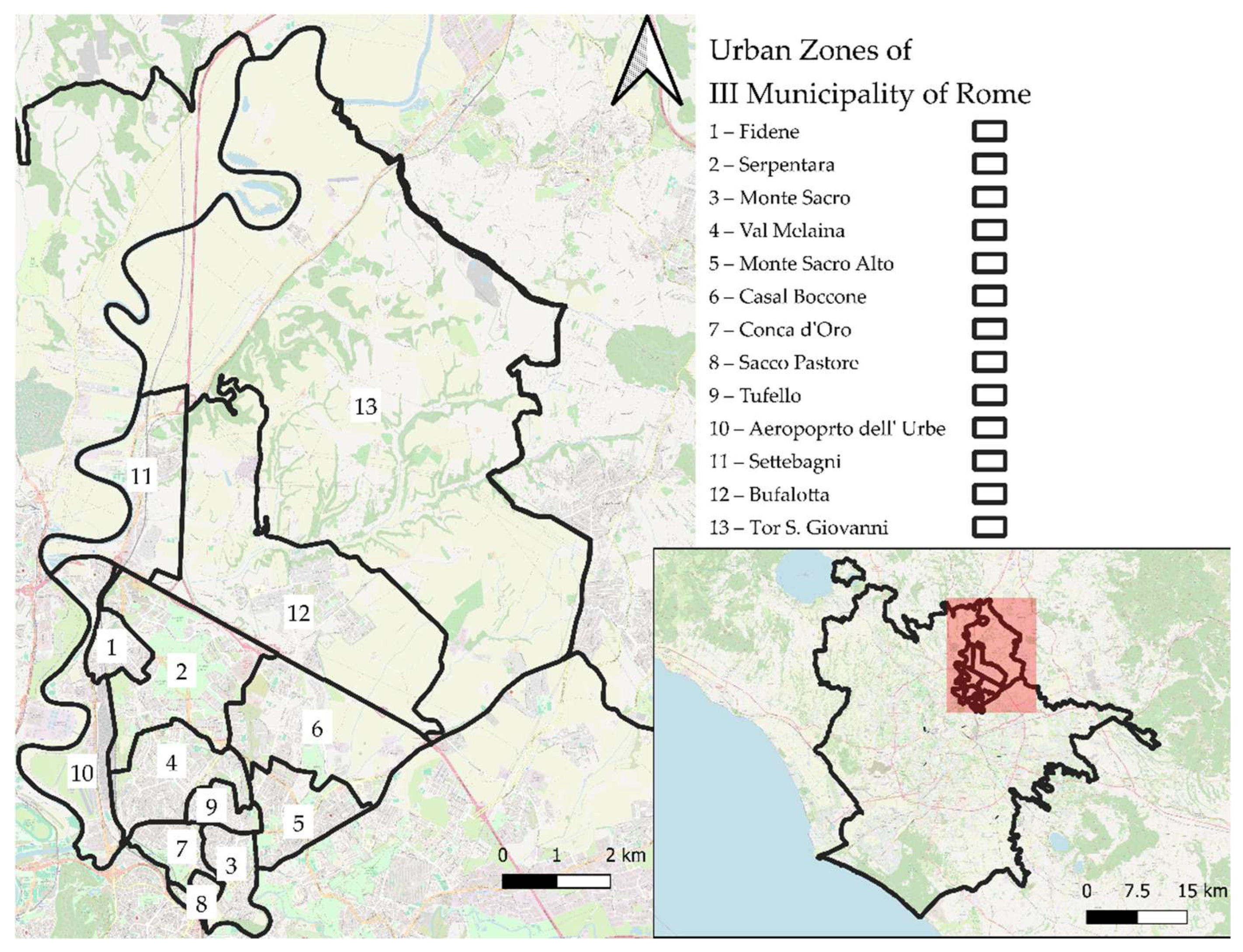
Figure 1.
Urban zones of III Municipality of Rome. The red box in the overview map corresponds to the geographical extent displayed in the main map.
Figure 1.
Urban zones of III Municipality of Rome. The red box in the overview map corresponds to the geographical extent displayed in the main map.
Figure 2.
Methodological process for the subdivision of Urban Zones (UZs) and identification of Mesoareas. The flowchart illustrates the sequential steps based on property market heterogeneity, major road networks, population thresholds, and statistical comparisons to define meaningful intra-urban sub-areas.
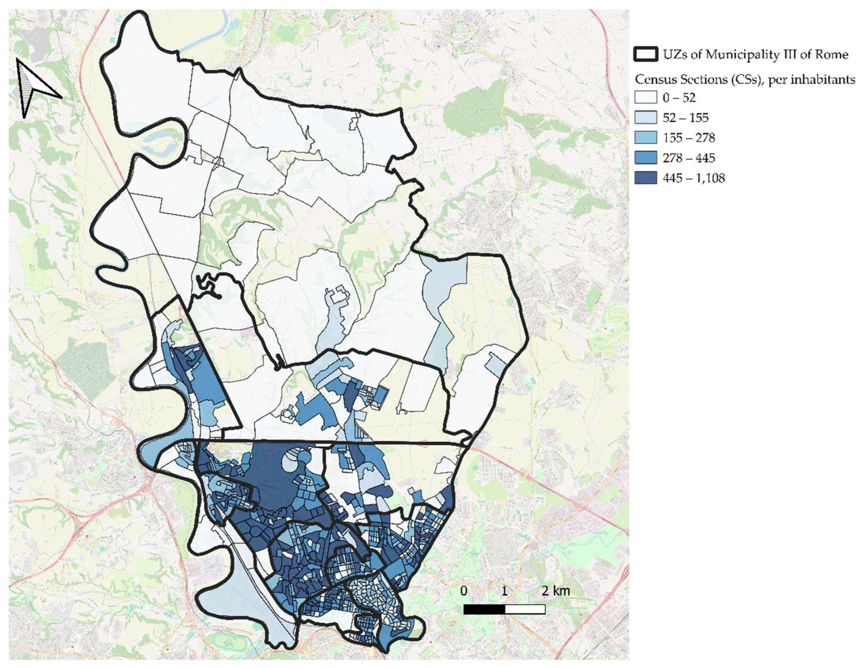
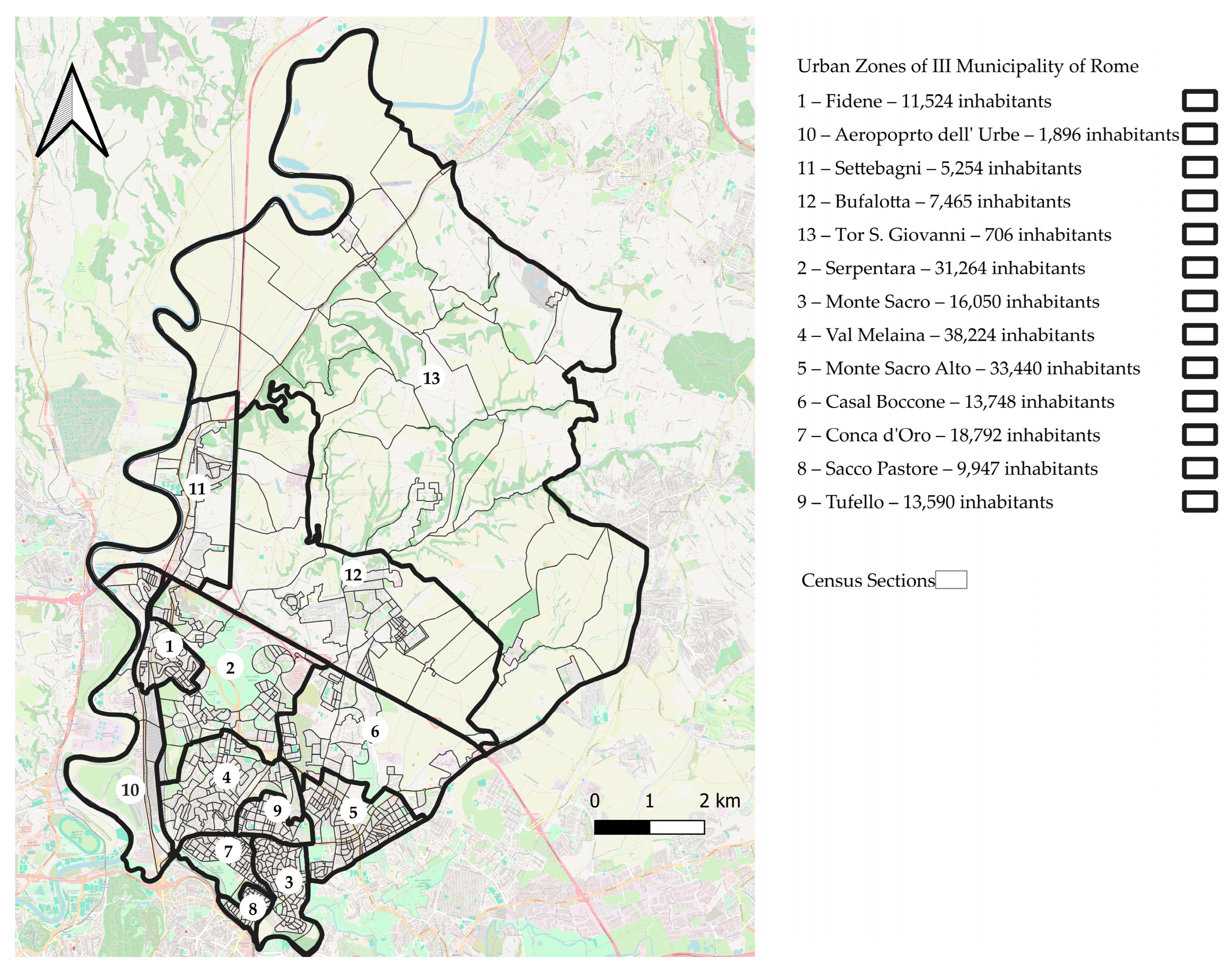
Figure 3.
Urban Zones (UZs) of Municipality III subdivided by census sections (CSs). The association between CSs and UZs was established using the methods described in Step 1 of the methodological process.
Figure 3.
Urban Zones (UZs) of Municipality III subdivided by census sections (CSs). The association between CSs and UZs was established using the methods described in Step 1 of the methodological process.
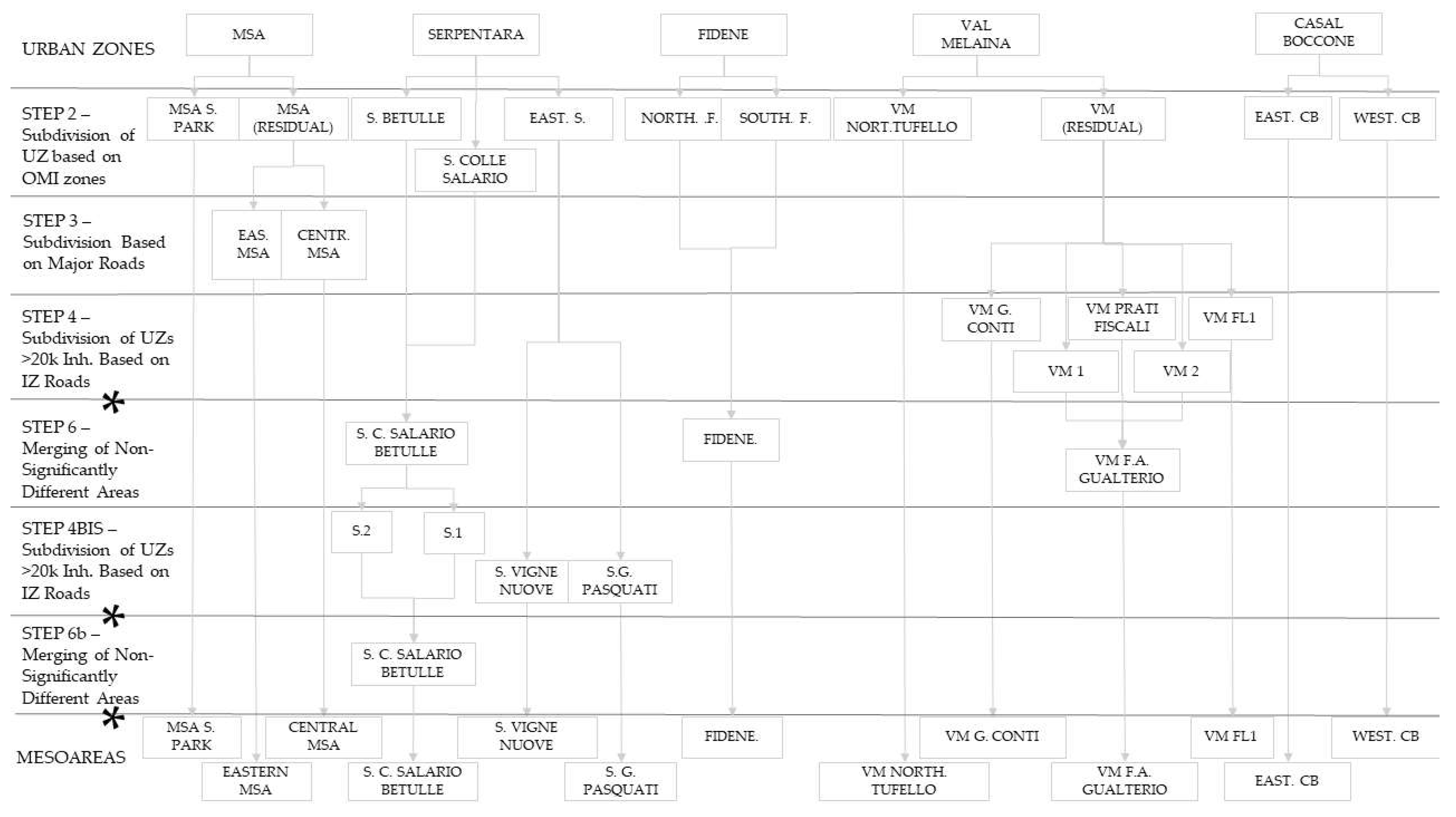
Figure 4.
Results of the subdivision of Urban Zones (UZs) based on real estate market heterogeneity and road axes. Asterisks (*) indicate the steps at which statistical analyses were conducted to assess differences in the percentage of university graduates across Mesoareas within the same UZ. Abbreviations: S = Serpentara; VM = Val Melaina; CB = Casal Boccone; MSA = Monte Sacro Alto; F = Fidene. Tufello, Aeroporto dell’Urbe, Tor San Giovanni, Bufalotta, Monte Sacro, Settebagni and Conca d’Oro UZs were not subject to further subdivision.
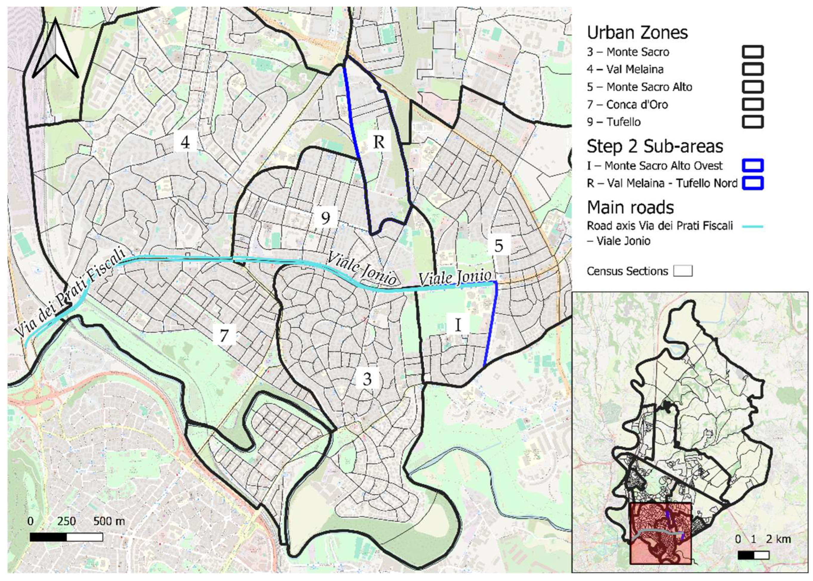
Figure 6.
The image illustrates the Step 2 subdivision process of the Fidene (UZ). In the Urban Zone of Fidene, two OMI zones are present: E40, with higher average property sale prices, and E41. The census sections (CSs) whose centroids fall within OMI zone E40 were grouped to form the sub-area Fidene North (E), while those falling within OMI zone E41 constitute the sub-area Fidene South (F). The red box in the overview map corresponds to the geographical extent displayed in the main map.
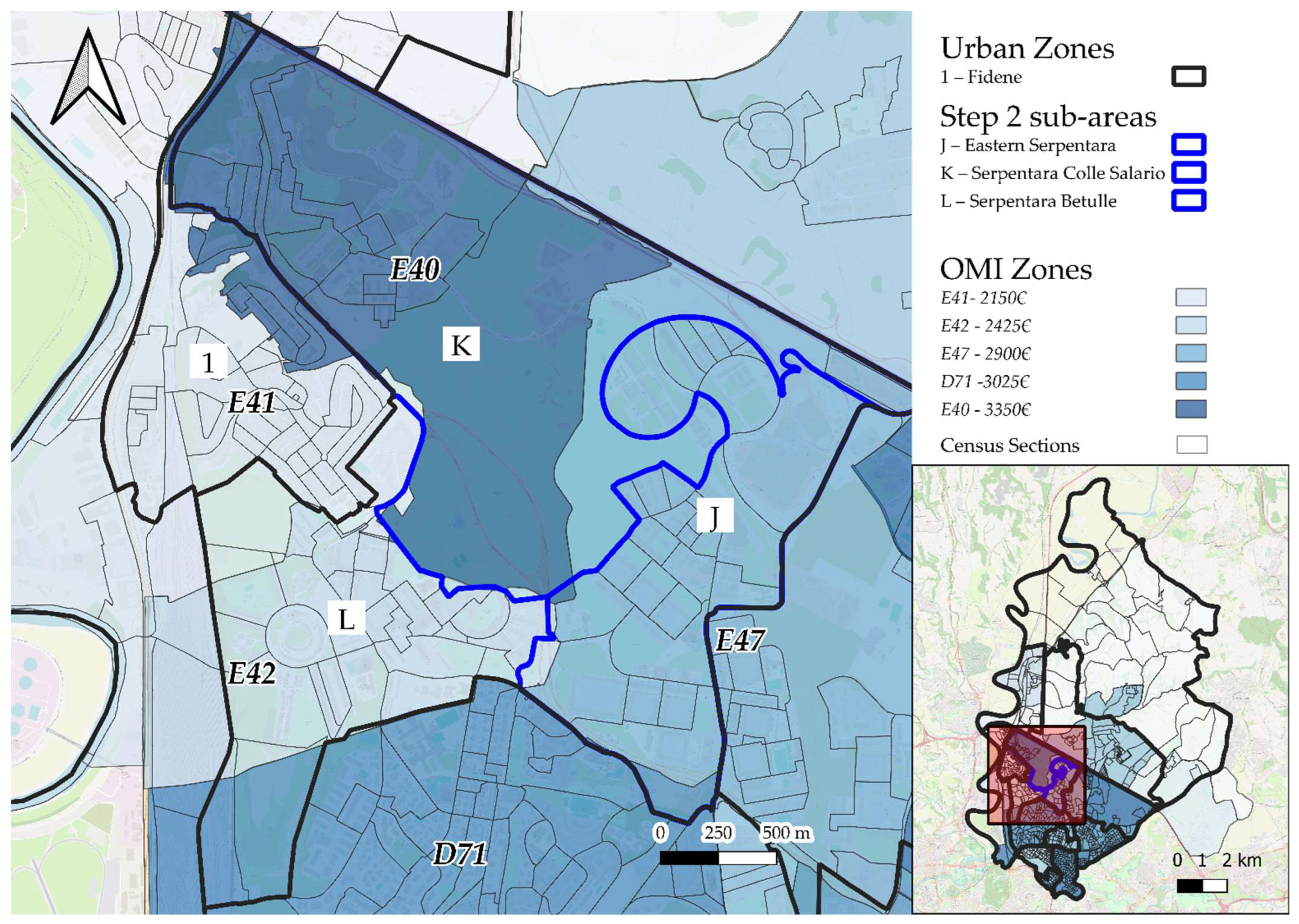
Figure 7.
The image illustrates the Step 2 subdivision process of the Serpentara Urban Zone (UZ). Three OMI zones fall within this UZ: E40, with the highest average property sale price; E47, with an intermediate value; and E42, with the lowest value. Census sections (CSs) whose centroids fall within OMI zone E40 were grouped into the sub-area Serpentara Colle Salario (K); those falling in E47 formed Serpentara Est (J); and those in E42 formed Serpentara Betulle (L). In the northern part of Serpentara, bordering the Fidene UZ (1), some CSs fall into OMI zone E41. These CSs, comprising 1351 inhabitants, were included in Serpentara Betulle. CSs located in the southernmost portion of the UZ, falling within OMI zone D71 and containing zero inhabitants, were also assigned to Serpentara Betulle. The red box in the overview map corresponds to the geographical extent displayed in the main map.
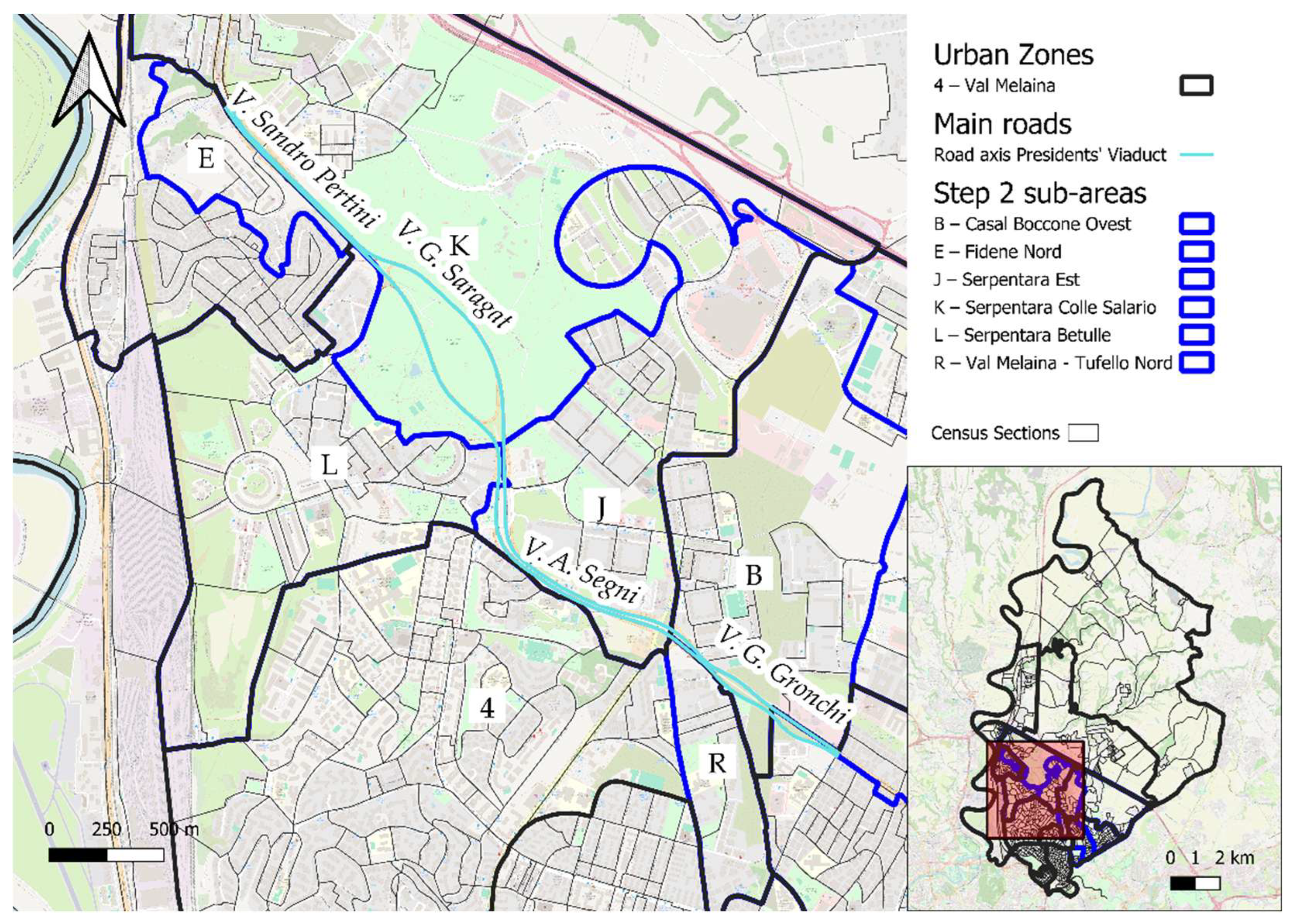
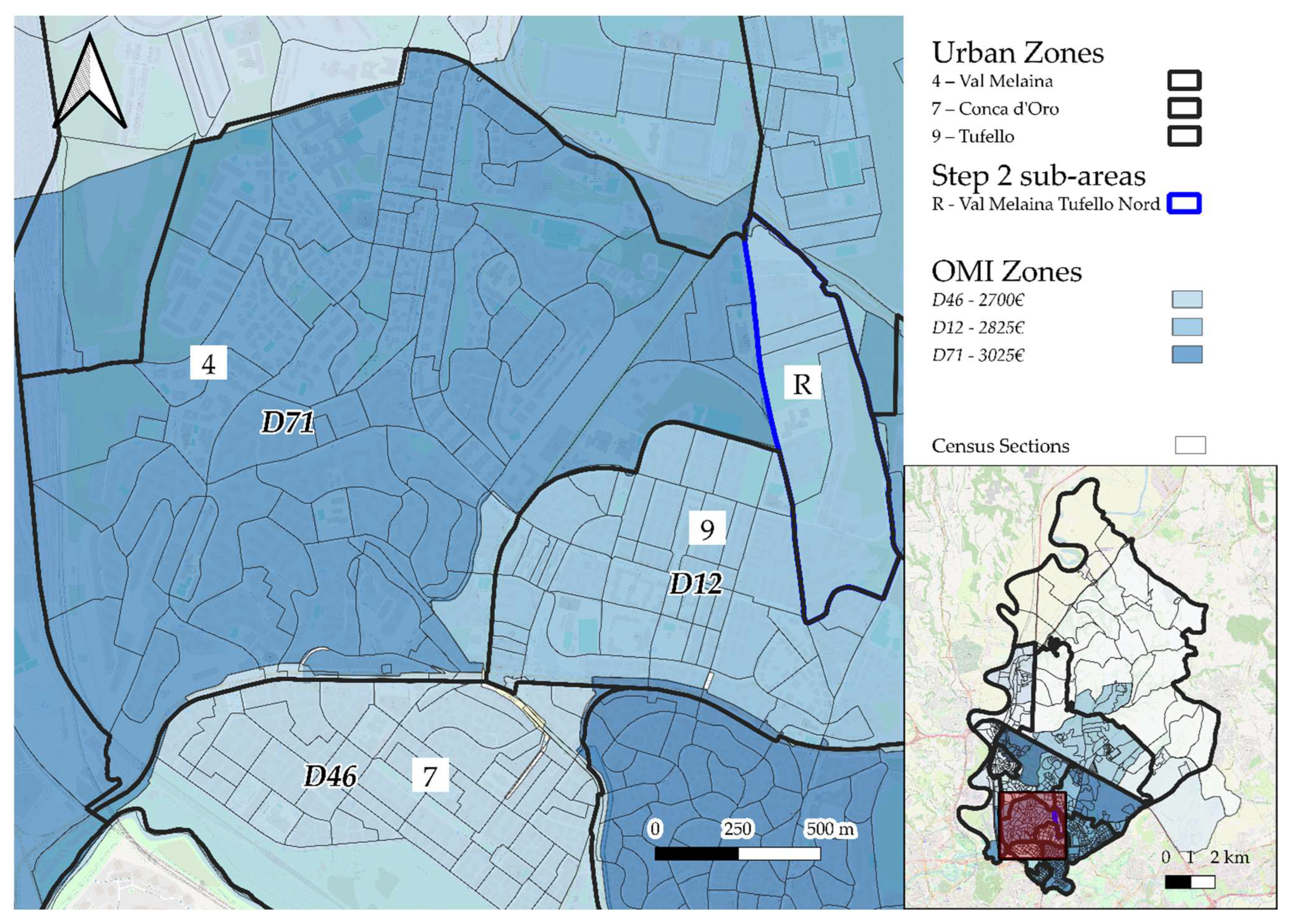
Figure 8.
The image shows the subdivision process of the Val Melaina Urban Zone (UZ) based on Step 2. Two OMI zones intersect this UZ: D71, with a higher average residential property sale price, and D12. The census sections (CSs) whose centroids fall within OMI zone D12 were grouped into the sub-area Northern Tufello (E). Some CSs along the border with the adjacent Tufello UZ also fall within D12; as these CSs account for fewer than 1500 residents, they were included in the portion of Val Melaina that was not subdivided, further designated as the Val Melaina Residual Area. The red box in the overview map corresponds to the geographical extent displayed in the main map.
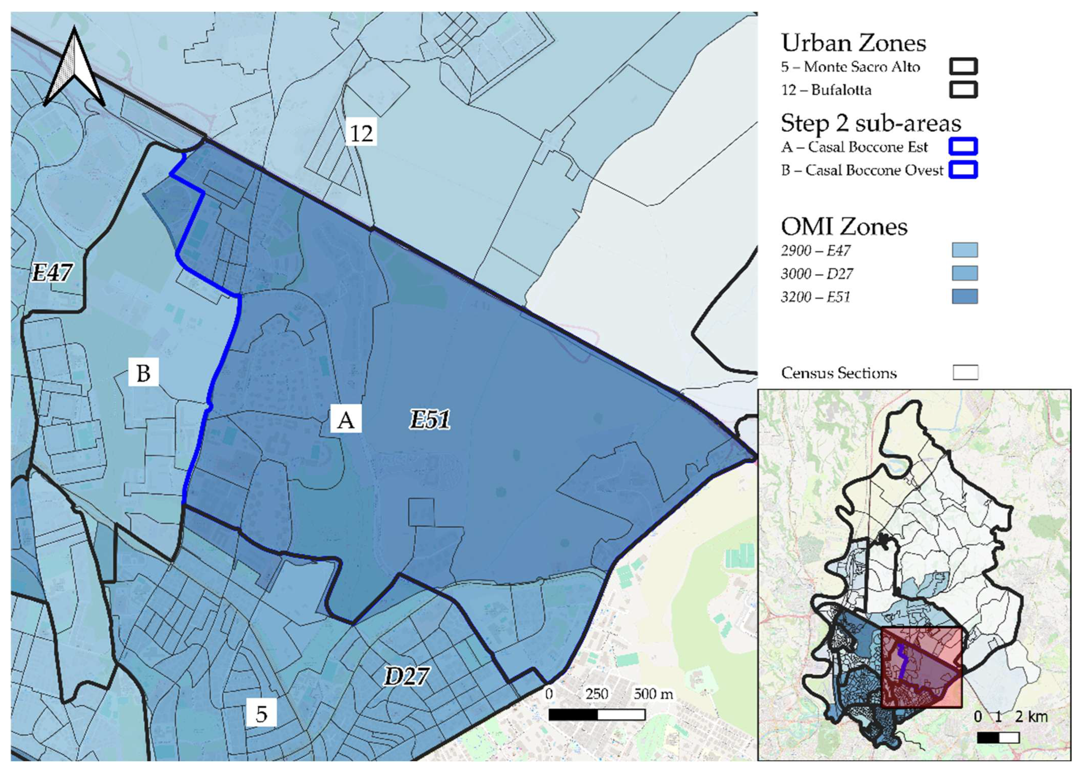
Figure 9.
The figure shows the subdivision process of the Casal Boccone Urban Zone (UZ) based on Step 2. Two main OMI zones intersect this UZ: E51, with the highest average residential property sale price, and E47, with a lower price. The census sections (CSs) whose centroids fall within OMI zone E51 were grouped into the sub-area Casal Boccone East (A), while those falling within OMI zone E47 formed the sub-area Casal Boccone West (B). In the northern portion of Casal Boccone, at the border with Monte Sacro Alto UZ (5), some CSs fall within OMI zone D27; these CSs, with a total population of 536 inhabitants, were included in the Serpentara Betulle area. The southernmost CSs, falling within OMI zone D71 and containing no inhabitants, were also considered part of Casal Boccone East. The red box in the overview map corresponds to the geographical extent displayed in the main map.
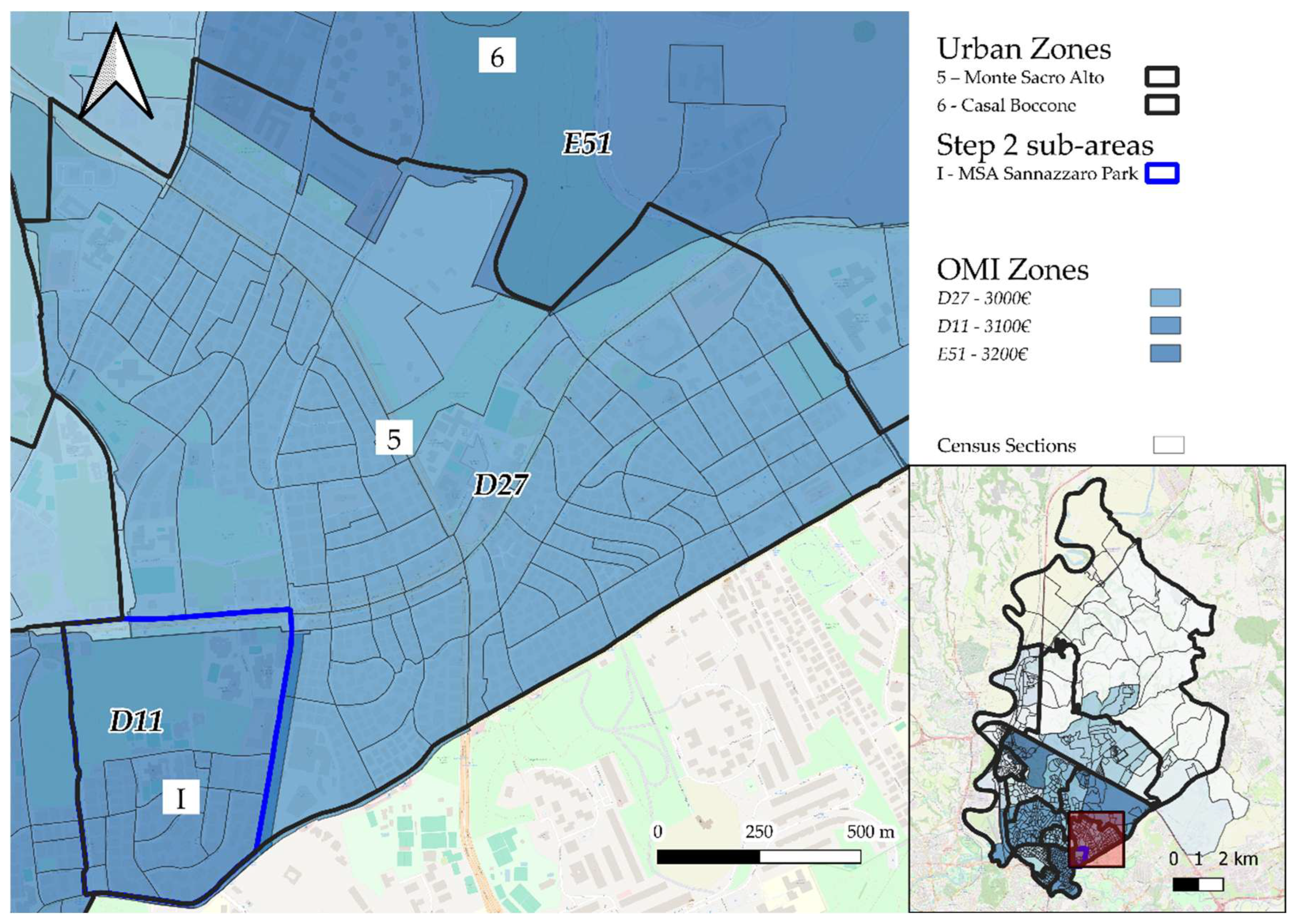
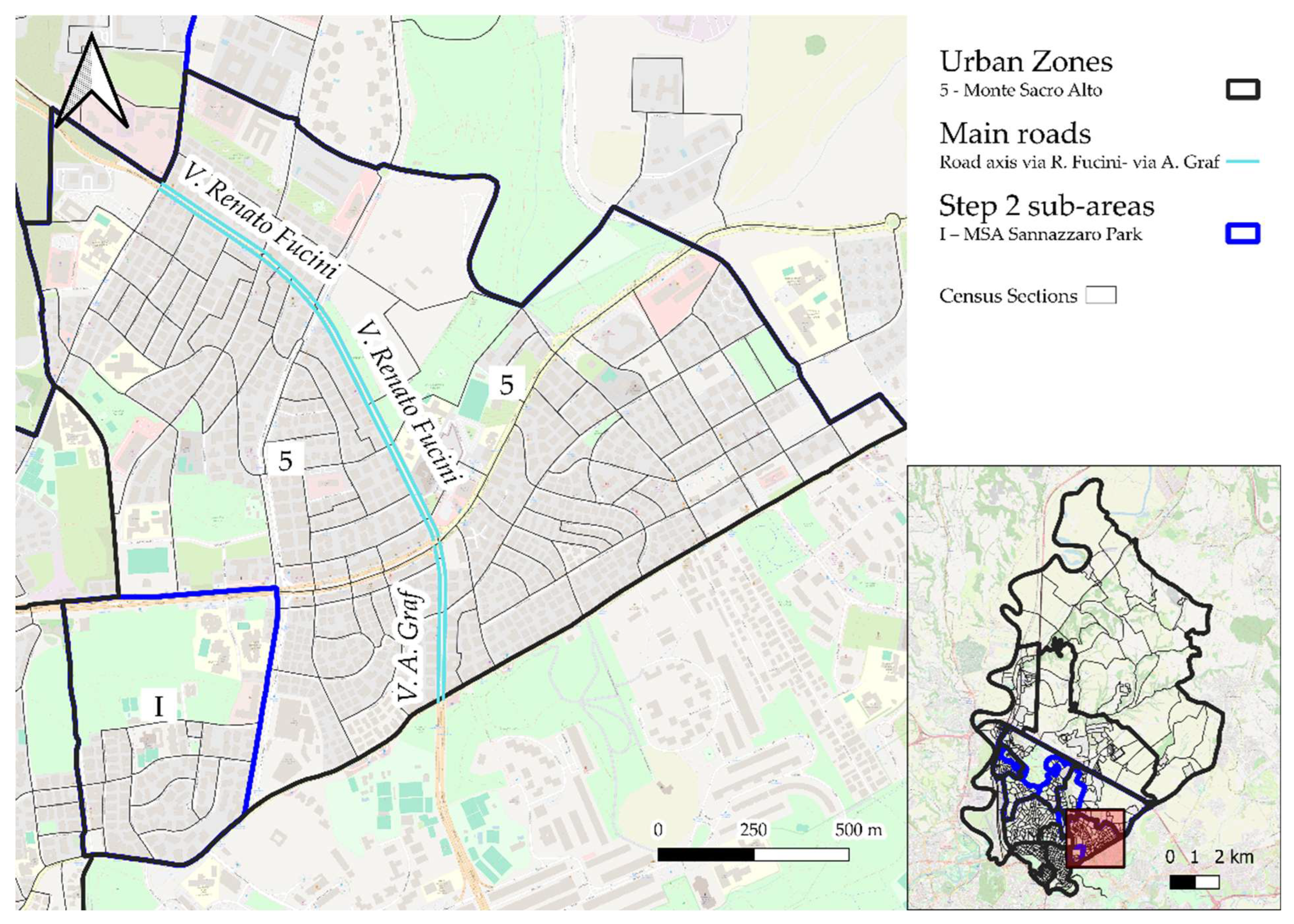
Figure 10.
The image illustrates the subdivision process of the Monte Sacro Alto (MSA) Urban Zone (UZ) based on Step 2. Two main OMI zones intersect this UZ: D11, with the highest average residential property sale price, and D27, with the lowest. The census sections (CSs) whose centroids fall within OMI zone D11 were grouped into the sub-area MSA Sannazzaro Park (I). In the southern part of MSA, near the border with Casal Boccone UZ (6), some CSs fall within OMI zone E51. These CSs, with a combined population of 960 inhabitants, were included in the portion of MSA that was not further subdivided, designated as the MSA Residual Area. The red box in the overview map corresponds to the geographical extent displayed in the main map.
Figure 11.
The image shows the road axis formed by Via Renato Fucini (to the north) and Via Arturo Graf (to the south). This road axis crosses the residual area of Monte Sacro Alto (MSA) that remained after the subdivision carried out in Step 2. It was used as a reference to further divide the census sections of MSA into two sub-areas: one located east of the axis, named MSA Est (14,433 inhabitants), and one to the west, between the road axis and MSA Sannazzaro Park, named MSA Centrale (16,334 inhabitants). The red box in the overview map corresponds to the geographical extent displayed in the main map.
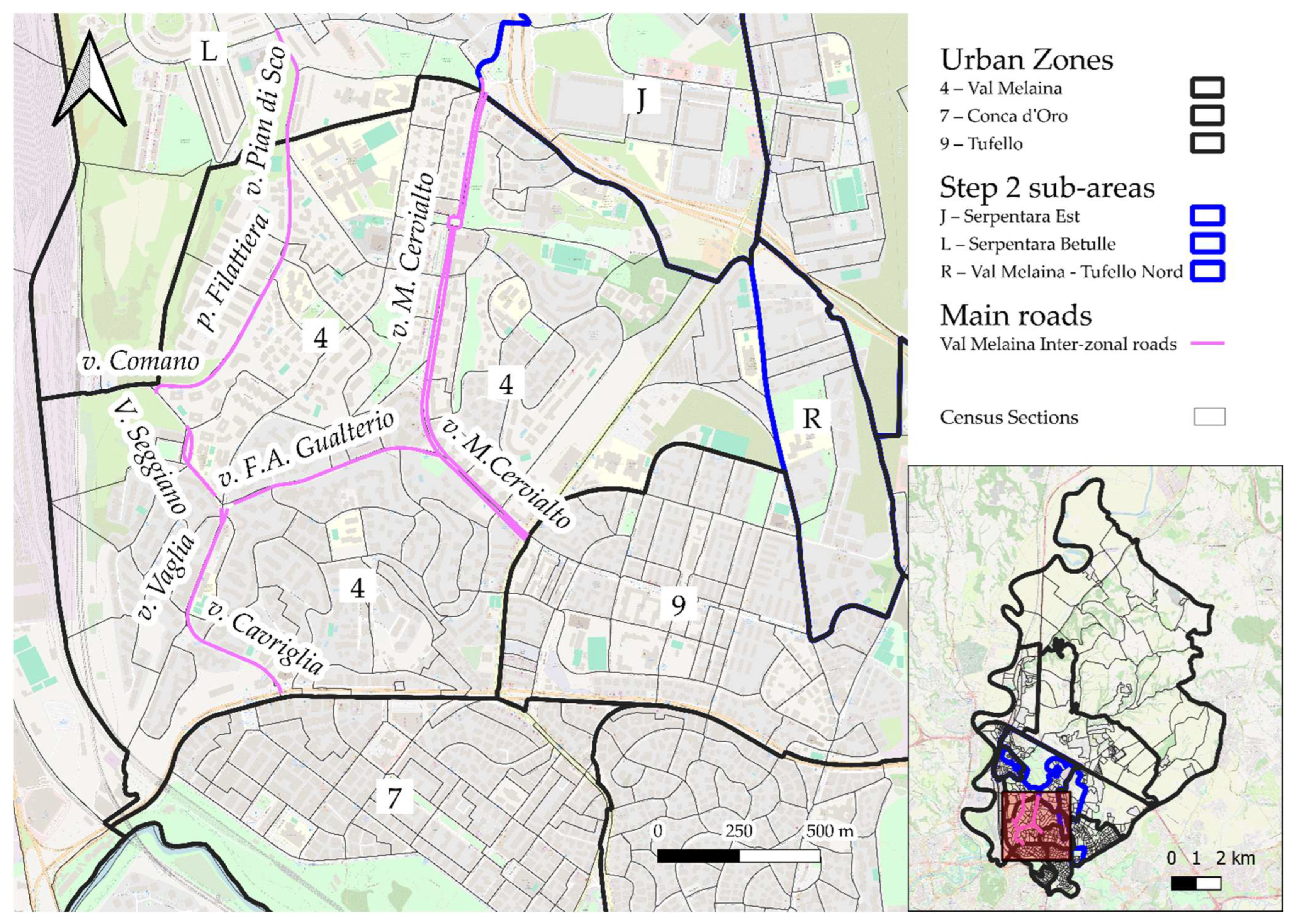
Figure 12.
The image illustrates the inter-zonal roads within the Urban Zone (UZ) of Val Melaina. These road axes were used to delineate five additional sub-areas within Val Melaina: one to the west of the Seggiano–Vaglia–Cavriglia axis, named ‘Val Melaina FL1’; one to the northwest of the Comano–Filattiera–Pian di Sco axis, named ‘Val Melaina 1’; one southeast of this axis and bounded by Via Seggiano, Via Gualterio, Via Monte Cervialto, and the border with the sub-areas of Serpentara (L, J), named ‘Val Melaina 2’; one east of Via Monte Cervialto, named ‘Val Melaina Giovanni Conti’; and one bordered to the northeast by Via Cavriglia, Via Vaglia, Via Gualterio, and Via Monte Cervialto, and to the southwest by the boundaries with Conca d’Oro (7) and Tufello (9), named ‘Val Melaina Prati Fiscali’. The red box in the overview map corresponds to the geographical extent displayed in the main map.
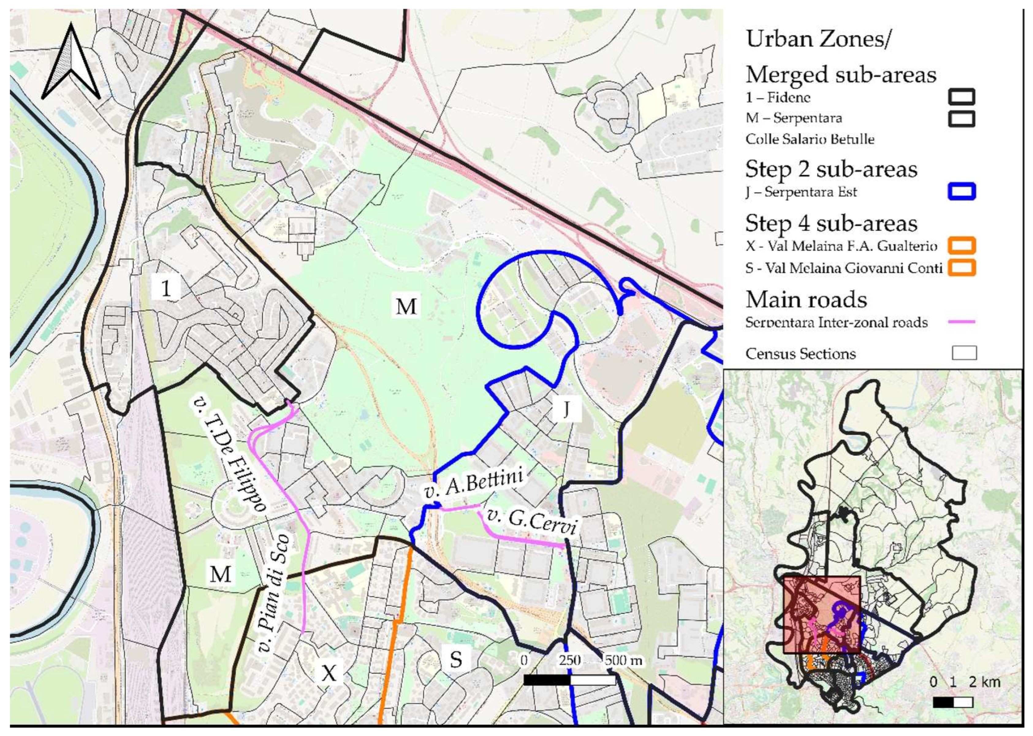
Figure 13.
The image displays the inter-zonal roads within the Urban Zone of Serpentara. The road axis formed by Via Titina De Filippo and Via Pian di Sco allows for the subdivision of the broader Serpentara Colle Salario Betulle area—created through the merging operations in Step 6—into two sub-areas: one to the east of the axis, named Serpentara 2, and one to the west, named Serpentara 3. Additionally, the road axis composed of Via Amalia Bettini and Viale Gino Cervi enables the subdivision of the Serpentara Est area into two further sub-areas: a smaller southern portion called Serpentara Giulio Pasquati, and a larger northern portion referred to as Serpentara Vigne Nuove. The red box in the overview map corresponds to the geographical extent displayed in the main map.
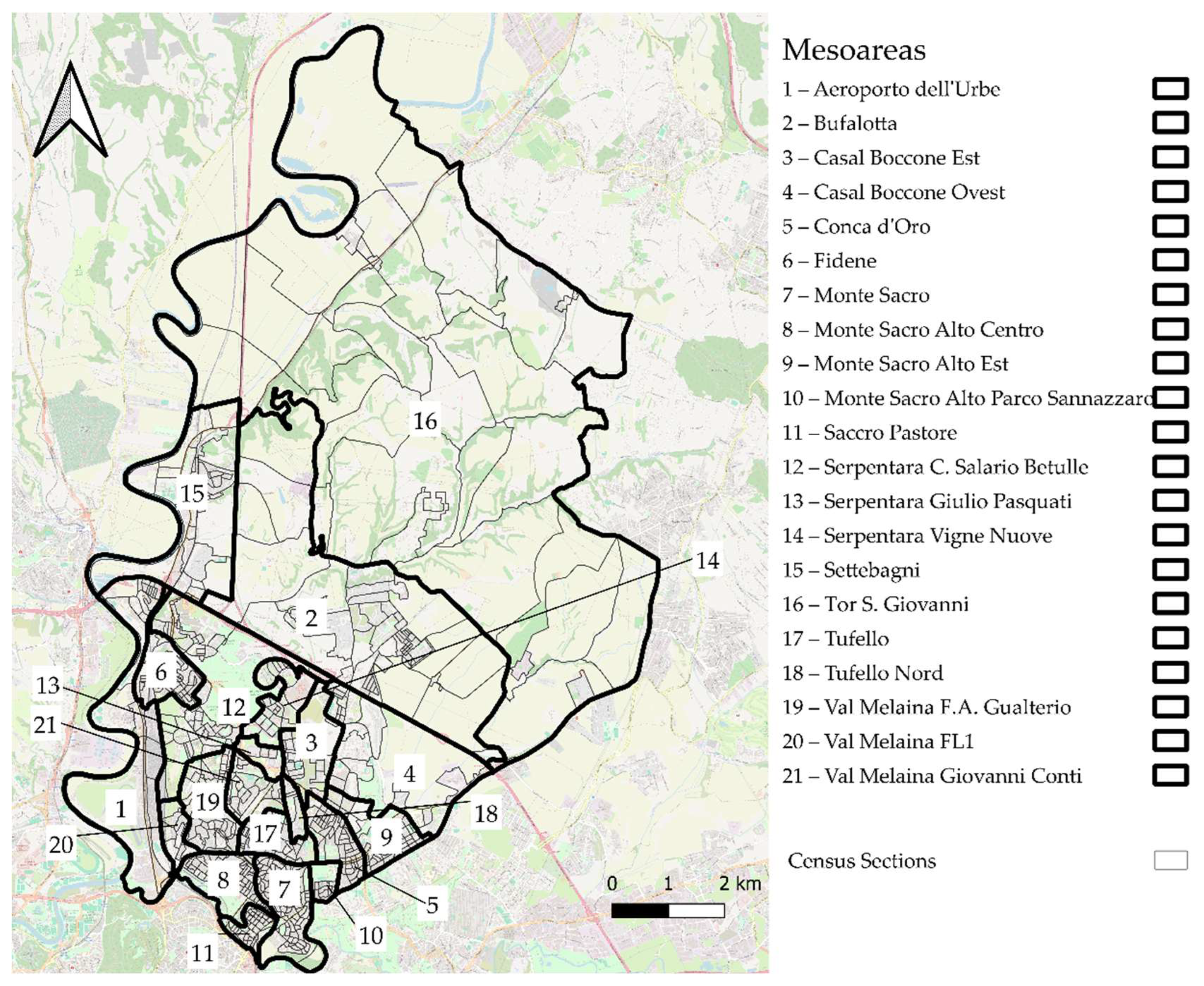
Figure 14.
This figure illustrates the Mesoareas derived from the subdivision of Urban Zones (UZs), produced and retained following the sequence of methodological steps outlined earlier.
Figure 14.
This figure illustrates the Mesoareas derived from the subdivision of Urban Zones (UZs), produced and retained following the sequence of methodological steps outlined earlier.
Figure 15.
Mesoareas of the III Municipality of Rome.
Figure 15.
Mesoareas of the III Municipality of Rome.
Table 1.
Overview of the main data sources used for the delineation of Mesoareas and the analysis of socioeconomic indicators within the Urban Zones of Municipality III. For each dataset, the type of data and the corresponding source are reported.
Table 1.
Overview of the main data sources used for the delineation of Mesoareas and the analysis of socioeconomic indicators within the Urban Zones of Municipality III. For each dataset, the type of data and the corresponding source are reported.
| Dataset Description | Year | Source |
|---|
| Vector layer of 2021 census sections of the Municipality of Rome, including both point and polygon geometries. | 2021 | ISTAT (Istituto Nazionale di Statistica) |
| Database containing demographic and socioeconomic data from the 2021 ISTAT Census, joined to the spatial layer of census sections. | 2021 | ISTAT (Istituto Nazionale di Statistica) |
| Vector layer of administrative subdivisions (Municipalities). | Accessed May 2025 | IPTSAT s.r.l., via DatiOpen.it platform |
| Vector layer of Urban Zones (Zone Urbanistiche) of the Municipality of Rome in WGS 84 coordinate system. | Accessed May 2025 | Roma Capitale/Geoportale |
| Vector layer of OMI (Osservatorio del Mercato Immobiliare) Zones, with minimum and maximum property sale and rental prices per square meter. Used to calculate average residential sale prices. | 2021 | Agenzia delle Entrate—OMI |
| Linear vector layer of the national road network. | Accessed May 2025 | ANAS S.p.A. (Azienda Nazionale Autonoma delle Strade) |
Table 2.
This table reports the description of the Urban Zones within III Municipality, including their area and 2021 ISTAT population, as derived from the procedures described above.
Table 2.
This table reports the description of the Urban Zones within III Municipality, including their area and 2021 ISTAT population, as derived from the procedures described above.
| Urban Zone | Area (km2) | Inhabitants (ISTAT 2021) |
|---|
| Aeroporto dell’ Urbe | 4.4 | 1896 |
| Bufalotta | 13.9 | 7465 |
| Casal Boccone | 5.7 | 13,748 |
| Conca d’Oro | 1.2 | 18,792 |
| Fidene | 1.1 | 11,524 |
| Monte Sacro | 1.7 | 16,050 |
| Monte Sacro Alto | 2.6 | 33,440 |
| Sacco Pastore | 0.5 | 9947 |
| Serpentara | 5.9 | 31,264 |
| Settebagni | 4.8 | 5254 |
| Tor S. Giovanni | 51.9 | 706 |
| Tufello | 0.9 | 13,590 |
| Val Melaina | 3.2 | 38,224 |
| III Municipality of Rome | 97.9 | 201,900 |
Table 3.
The table presents the OMI zones falling within each Urban Zone (UZ), identified through the intersection between the centroid layer of the 2021 census sections within each UZ and the polygon vector layer of the OMI zones, as described in Step 2. The table also reports the corresponding population figures based on the 2021 census data.
| Urban Zones | OMI Zones | Inhabitants | Actions |
|---|
| Aeroporto dell’Urbe | D71 | 178 | None |
| E16 | 1589 | None |
| E41 | 129 | None |
| E42 | | None |
| Bufalotta | E101 | 5 | None |
| E123 | 7425 | None |
| R7 | 35 | None |
| Casal Boccone | D27 | 536 | Considered part of Casal Boccone |
| E47 | 6192 | Led to the definition of Western Casal Boccone |
| E51 | 7020 | Led to the definition of Eastern Casal Boccone |
| Conca d’Oro | D46 | 18,784 | None |
| D47 | 8 | None |
| D11 | 0 | None |
| Fidene | E40 | 2288 | Led to the definition of Northern Fidene |
| E41 | 9236 | Led to the definition of Southern Fidene |
| Monte Sacro | D11 | 15,462 | None |
| D46 | 588 | None |
| d47 | 0 | None |
| Monte Sacro Alto | D11 | 2673 | Led to the definition of Monte Sacro Alto Sannazzaro Park |
| D27 | 29,807 | Led to the definition of Monte Sacro Alto (Residual Area) |
| E51 | 960 | Considered part of Monte Sacro Alto (Residual Area) |
| Sacco Pastore | D46 | 2 | None |
| D47 | 9945 | None |
| D11 | 0 | None |
| Settebagni | E16 | 590 | None |
| E50 | 4664 | None |
| Serpentara | E40 | 9681 | Led to the definition of Serpentara Colle Salario |
| E41 | 1351 | Considered part of Serpentara Betulle |
| E42 | 10,346 | Led to the definition of Serpentara Betulle |
| E47 | 9886 | Led to the definition of Eastern Serpentara |
| D71 | 0 | Led to the definition of Serpentara Colle Salario |
| Tor S. Giovanni | E101 | 146 | None |
| E123 | 180 | None |
| R7 | 380 | None |
| Val Melaina | D12 (eastern area) | 2164 | Led to the definition of Northern Tufello |
| D12 (central-southern area) | 1239 | Considered part of Val Melaina (Residual Area) |
| D71 | 34,821 | Led to the definition of Residual Val Melaina |
| Tufello | D12 | 13,590 | None |
| | | None |
Table 4.
Sub-areas resulting from the subdivisions due to heterogeneity in average real estate sale prices or main road axis.
Table 4.
Sub-areas resulting from the subdivisions due to heterogeneity in average real estate sale prices or main road axis.
| Mesoareas | Inhabitants (ISTAT 2021) |
|---|
| Aeroporto dell’Urbe | 1896 |
| Bufalotta | 7465 |
| Eastern Casal Boccone | 7556 |
| Western Casal Boccone | 6192 |
| Conca d’Oro | 18,792 |
| Northern Fidene | 2288 |
| Southern Fidene | 9236 |
| Monte Sacro | 16,050 |
| Central Monte Sacro Alto | 16,334 |
| Monte Sacro Alto Sannazzaro Park | 2673 |
| Eastern Montesacro Alto | 14,433 |
| Saccro Pastore | 9947 |
| Serpentara Vigne Nuove | 9886 |
| Serpentara Colle Salario | 9681 |
| Serpentara Betulle | 11,697 |
| Settebagni | 5254 |
| Northern Tor S. Giovanni | 299 |
| Southern S. Giovanni | 407 |
| Tufello | 13,590 |
| Northern Tufello | 2164 |
| Val Melaina (residual) | 36,060 |
| III Municipality | 201,900 |
Table 5.
Sub-areas resulting from the Step 2–4 subdivisions.
Table 5.
Sub-areas resulting from the Step 2–4 subdivisions.
| Mesoareas | Inhabitants (ISTAT 2021) |
|---|
| Aeroporto dell’Urbe | 1896 |
| Bufalotta | 7465 |
| Eastern Casal Boccone | 7556 |
| Western Casal Boccone | 6192 |
| Conca d’Oro | 18,792 |
| Northern Fidene | 2288 |
| Southern Fidene | 9236 |
| Monte Sacro | 16,050 |
| Central Monte Sacro Alto | 16,334 |
| Monte Sacro Alto Sannazzaro Park | 2673 |
| Eastern Montesacro Alto | 14,433 |
| Saccro Pastore | 9947 |
| Serpentara Est | 9886 |
| Serpentara Colle Salario | 9681 |
| Serpentara Betulle | 11,697 |
| Settebagni | 5254 |
| Tor S. Giovanni | 706 |
| Tufello | 13,590 |
| Val Melaina Northern Tufello | 2164 |
| Val Melaina Giovanni Conti | 9927 |
| Val Melaina Prati Fiscali | 11,743 |
| Val Melaina1 | 1883 |
| Val Melaina2 | 8602 |
| Val Melaina FL1 | 3905 |
| III Municipality | 201,900 |
Table 6.
Results from the chi2 analysis of differences in educational level per sub-area defined during Steps 2–4. Statistically significant results (p < 0.05) are shown in bold.
Table 6.
Results from the chi2 analysis of differences in educational level per sub-area defined during Steps 2–4. Statistically significant results (p < 0.05) are shown in bold.
| UZ | University Degree or More
N (%) | Lower than University Degree
N(%) | p |
|---|
| Casal Boccone | eastern | 2119 (35.8) | 3796 (64) | <0.001 |
| western | 1069 (20.4) | 4165 (89.6) |
| Fidene | northern | 310 (16.4) | 1584 (83.6) | 0.267 |
| southern | 1316 (17.4) | 6228 (82.6) |
| Monte Sacro Alto | Central | 5320 (39.5) | 8139 (60.5) | <0.001 |
| Sannazzaro Park | 1057 (48.0) | 1144 (52.0) |
| Monte Sacro Alto | Central | 5320 (39.5) | 8139 (60.5) | 0.010 |
| Eastern | 4507 (37.9) | 7373 (62.1) |
| Monte Sacro Alto | Sannazzaro Park | 1057 (48.0) | 1144 (52.0) | <0.001 |
| Eastern | 4107 (32.5) | 8514 (67.5) |
| Serpentara | Eastern | 2149 (26.8) | 5859 (73.2) | 0.253 |
| Colle Salario | 2076 (26.0) | 5897 (74.0) |
| Serpentara | Eastern | 2149 (26.8) | 5859 (73.2) | 0.024 |
| Betulle | 2553 (25.4) | 7515 (74.6) |
| Serpentara | Colle Salario | 2076 (26.0) | 5897 (74.0) | 0.300 |
| Betulle | 2553 (25.4) | 7515 (74.6) |
| Val Melaina | Northern Tufello | 583 (32.5) | 1212 (67.5) | <0.001 |
| Giovanni Conti | 2117 (25.7) | 6111 (74.3) |
| Val Melaina | Northern Tufello | 583 (32.5) | 1212 (67.5) | 0.029 |
| Prati Fiscali | 3388 (35.2) | 6248 (64.8) |
| Val Melaina | Northern Tufello | 583 (32.5) | 1212 (67.5) | <0.001 |
| 1 | 575 (38.3) | 926 (61.7) |
| Val Melaina | Northern Tufello | 583 (32.5) | 1212 (67.5) | 0.015 |
| 2 | 2559 (35.6) | 4639 (64.4) |
| Val Melaina | Giovanni Conti | 2117 (25.7) | 6111 (74.3) | <0.001 |
| Prati Fiscali | 3388 (35.2) | 6248 (64.8) |
| Val Melaina | Giovanni Conti | 2117 (25.7) | 6111 (74.3) | <0.001 |
| 1 | 575 (38.3) | 926 (61.7) |
| Val Melaina | Giovanni Conti | 2117 (25.7) | 6111 (74.3) | <0.001 |
| 2 | 2559 (35.6) | 4639 (64.4) |
| Val Melaina | Prati Fiscali | 3388 (35.2) | 6248 (64.8) | 0.018 |
| 1 | 575 (38.3) | 926 (61.7) |
| Val Melaina | Prati Fiscali | 3388 (35.2) | 6248 (64.8) | 0.599 |
| 2 | 2559 (35.6) | 4639 (64.4) |
| Val Melaina | 1 | 575 (38.3) | 926 (61.7) | 0.043 |
| 2 | 2559 (35.6) | 4639 (64.4) |
| Val Melaina | FL1 | 1317 (40.5) | 1938 (59.5) | <0.001 |
| Northern Tufello | 583 (18.1) | 2630 (81.9) |
| Val Melaina | FL1 | 1317 (40.5) | 1938 (59.5) | <0.001 |
| Giovanni Conti | 2117 (25.7) | 6111 (74.3) |
| Val Melaina | FL1 | 1317 (40.5) | 1938 (59.5) | <0.001 |
| Prati Fiscali | 3388 (35.2) | 6248 (64.8) |
| Val Melaina | FL1 | 1317 (40.5) | 1938 (59.5) | <0.001 |
| 1 | 575 (22.4) | 1995 (77.6) |
| Val Melaina | FL1 | 1317 (40.5) | 1938 (59.5) | <0.001 |
| 2 | 2559 (35.6) | 4639 (64.4) |
Table 7.
Mesoareas resulting from the subdivisions due to extensive dimensions, heterogeneity in average real estate sale prices or main road axis, or large number of inhabitants.
Table 7.
Mesoareas resulting from the subdivisions due to extensive dimensions, heterogeneity in average real estate sale prices or main road axis, or large number of inhabitants.
| Mesoareas | Inhabitants (ISTAT 2021) |
|---|
| Aeroporto dell’Urbe | 1896 |
| Bufalotta | 7465 |
| Eastern Casal Boccone | 7556 |
| Western Casal Boccone | 6192 |
| Conca d’Oro | 18,792 |
| Fidene | 11,524 |
| Monte Sacro | 16,050 |
| Central Monte Sacro Alto | 16,334 |
| Monte Sacro Alto Sannazzaro Park | 2673 |
| Eastern Montesacro Alto | 14,433 |
| Saccro Pastore | 9947 |
| Serpentara Est | 9886 |
| Serpentara Colle Salario Betulle | 21,378 |
| Settebagni | 5254 |
| Tor S. Giovanni | 706 |
| Tufello | 13,590 |
| Val Melaina Northern Tufello | 2164 |
| Val Melaina Giovanni Conti | 9927 |
| Val Melaina F.A. Gualterio | 22,228 |
| Val Melaina FL1 | 3905 |
| III Municipality | 201,900 |
Table 8.
The table shows the results of the Chi-squared tests conducted between the sub-areas derived from the Serpentara Urban Zone through the subdivisions carried out in Step 4b. Statistically significant results (p < 0.05) are shown in bold.
Table 8.
The table shows the results of the Chi-squared tests conducted between the sub-areas derived from the Serpentara Urban Zone through the subdivisions carried out in Step 4b. Statistically significant results (p < 0.05) are shown in bold.
| UZ | | University Degree or More n (%) | Lower than University Degree n (%) | p |
|---|
| Serpentara | 3 | 3462 (25.5) | 10,116 (74.5) | 0.387 |
| 2 | 1167 (26,1) | 4463 (73,9) |
| Serpentara | 3 | 3462 (25.5) | 10,116 (74.5) | <0.001 |
| Giulio Pasquati | 339 (14) | 2082 (86) |
| Serpentara | 2 | 1167 (26.1) | 1167 (26,1) | <0.001 |
| Giulio Pasquati | 339 (14) | 2082 (86%) |
| Serpentara | Vigne Nuove | 1810 (32,4) | 3777 (67.6) | <0.001 |
| 2 | 1167 (26,1) | 4463 (73.9) |
| Serpentara | Vigne Nuove | 1810 (32,4) | 3777 (67.6) | <0.001 |
| Giulio Pasquati | 339 (14) | 2082 (86%) |
| Serpentara | 3 | 3462 (25.5) | 10,116 (74.5) | <0.001 |
| Vigne Nuove | 1810 (32.4) | 3777 (67.6) |
Table 9.
The table shows the results of the Chi-squared tests conducted between the sub-areas derived from the Serpentara Urban Zone through the merging of sub-areas carried out in Step 6b. Statistically significant results (p < 0.05) are shown in bold.
Table 9.
The table shows the results of the Chi-squared tests conducted between the sub-areas derived from the Serpentara Urban Zone through the merging of sub-areas carried out in Step 6b. Statistically significant results (p < 0.05) are shown in bold.
| UZ | | University Degree or More n (%) | Lower than University Degree n (%) | p |
|---|
| Serpentara | CS Betulle | 4629 (25.7) | 13,412 (74.3) | <0.001 |
| Giulio Pasquati | 339 (14) | 2082 (86) |
| Serpentara | Vigne Nuove | 1810 (32,4) | 3777 (67.6) | <0.001 |
| CS Betulle | 4629 (25.7) | 13,412 (74.3) |
| Serpentara | Vigne Nuove | 1810 (32,4) | 3777 (67.6) | <0.001 |
| Giulio Pasquati | 339 (14) | 2082 (86%) |
Table 10.
III Municipality of Rome, Mesoareas.
Table 10.
III Municipality of Rome, Mesoareas.
| Mesoareas | Inhabitants (ISTAT 2021) |
|---|
| Aeroporto dell’Urbe | 1896 |
| Bufalotta | 7465 |
| Eastern Casal Boccone | 7556 |
| Western Casal Boccone | 6192 |
| Conca d’Oro | 18,792 |
| Fidene | 11,524 |
| Monte Sacro | 16,050 |
| Central Monte Sacro Alto | 16,334 |
| Monte Sacro Alto Sannazzaro Park | 2673 |
| Eastern Montesacro Alto | 14,433 |
| Saccro Pastore | 9947 |
| Serpentara Vigne Nuove | 7092 |
| Serpentara Colle Salario Betulle | 21,378 |
| Serpentara Giulio Pasquati | 2794 |
| Settebagni | 5254 |
| Tor S. Giovanni | 706 |
| Tufello | 13,590 |
| Northern Tufello | 2164 |
| Val Melaina Giovanni Conti | 9927 |
| Val Melaina FL1 | 3905 |
| Val Melaina F.A. Gualterio | 22,228 |
| III Municipality | 201,900 |
Table 11.
Descriptive statistics (mean, variance, median, and interquartile range) for educational attainment across all Urban Zones within Municipality III.
Table 11.
Descriptive statistics (mean, variance, median, and interquartile range) for educational attainment across all Urban Zones within Municipality III.
| Urban Zones | Mean | Variance | Median | IQR |
|---|
| Fidene | 0.165 | 0.002 | 0.167 | 0.059 |
| Sacco Pastore | 0.389 | 0.005 | 0.391 | 0.075 |
| Conca d’Oro | 0.382 | 0.006 | 0.381 | 0.087 |
| Monte Sacro Alto | 0.400 | 0.007 | 0.401 | 0.089 |
| Settebagni | 0.237 | 0.008 | 0.222 | 0.076 |
| Monte Sacro | 0.454 | 0.009 | 0.465 | 0.11 |
| Bufalotta | 0.212 | 0.009 | 0.183 | 0.151 |
| Tufello | 0.187 | 0.009 | 0.167 | 0.13 |
| Tor S. Giovanni | 0.183 | 0.010 | 0.182 | 0.173 |
| Val Melaina | 0.335 | 0.011 | 0.345 | 0.157 |
| Serpentara | 0.261 | 0.011 | 0.275 | 0.137 |
| Aeroporto dell’ Urbe | 0.188 | 0.013 | 0.164 | 0.098 |
Table 12.
Descriptive statistics (mean, variance, median, and interquartile range) for educational attainment across all Mesoareas within Municipality III.
Table 12.
Descriptive statistics (mean, variance, median, and interquartile range) for educational attainment across all Mesoareas within Municipality III.
| Urban Zones | Mean | Variance | Median | IQR |
|---|
| Fidene | 0.165 | 0.002 | 0.167 | 0.059 |
| Monte Sacro Alto Sannazzaro Park | 0.493 | 0.003 | 0.482 | 0.074 |
| Val Melaina FL1 | 0.408 | 0.004 | 0.425 | 0.074 |
| Serpentara Giulio Pasquati | 0.140 | 0.004 | 0.123 | 0.08 |
| Monte Sacro Alto East | 0.386 | 0.005 | 0.371 | 0.108 |
| Saccro Pastore | 0.389 | 0.005 | 0.391 | 0.075 |
| Conca d’Oro | 0.382 | 0.006 | 0.381 | 0.087 |
| Northern Tufello | 0.286 | 0.007 | 0.295 | 0.138 |
| Serpentara Vigne Nuove | 0.326 | 0.007 | 0.314 | 0.106 |
| Monte Sacro Alto Central | 0.395 | 0.007 | 0.405 | 0.07 |
| Settebagni | 0.237 | 0.008 | 0.222 | 0.076 |
| Val Melaina F.A. Gualterio | 0.354 | 0.008 | 0.35 | 0.134 |
| Monte Sacro | 0.454 | 0.009 | 0.465 | 0.11 |
| Bufalotta | 0.212 | 0.009 | 0.183 | 0.151 |
| Tufello | 0.187 | 0.009 | 0.167 | 0.13 |
| Serpentara Colle Salario Betulle | 0.238 | 0.010 | 0.257 | 0.145 |
| Tor S. Giovanni | 0.183 | 0.010 | 0.182 | 0.173 |
| Aeroporto dell’Urbe | 0.188 | 0.013 | 0.164 | 0.098 |
| Casal Boccone East | 0.296 | 0.013 | 0.278 | 0.232 |
| Val Melaina Giovanni Conti | 0.272 | 0.015 | 0.256 | 0.184 |
| Casal Boccone West | 0.233 | 0.016 | 0.221 | 0.248 |
Table 13.
Results of Kruskal–Wallis tests performed on the percentage of university graduates across subdivided Mesoareas within Urban Zones. Where three or more groups were compared, post-hoc pairwise comparisons using Dunn’s test with Bonferroni correction are presented. Statistically significant differences (p < 0.05) between specific Mesoareas are highlighted, illustrating localized variations in educational attainment. Statistically significant results (p < 0.05) are shown in bold.
| Urban Zone | No. of Mesoareas | Kruskal–Wallis Test (χ2, df) | Global p-Value | Significant Pairwise Comparisons (Dunn–Bonferroni) | Adjusted p-Value |
|---|
| Casal Boccone | 2 | 2.364
with 1 d.f. | 0.1242 | | |
| MSA | 3 | 17.493 with 2 d.f. | 0.0002 | MSA Sannazzaro Park vs. Central MSA | 0.0012 |
| MSA Sannazzaro Park vs. Eastern MSA | <0.001 |
| Serpentara | 3 | 15.674 with 2 d.f. | 0.0004 | Serpentara Vigne Nuove vs. Serpentara CS Betulle | 0.0018 |
| Serpentara Vigne Nuove vs. Serpentara Giulio Pasquati | 0.0023 |
| Val Melaina | 4 | 13.848 with 3 d.f. | 0.0031 | VM Giovanni Conti vs. VM F.A. Gualterio | 0.02 |
| VM Giovanni Conti vs. VM FL1 | 0.0032 |
Table 14.
Results from the chi2 analysis of differences in occupational status. Statistically significant results (p < 0.05) are shown in bold.
Table 14.
Results from the chi2 analysis of differences in occupational status. Statistically significant results (p < 0.05) are shown in bold.
| UZ | Employed (%) | Unemployed (%) | p |
|---|
| Casal Boccone | eastern | 3495 (67.8) | 1658 (32.2) | <0.001 |
| western | 2435 (61.5) | 1525 (38.5) |
| Monte Sacro Alto | Central | 6433 (65.4) | 3409 (34.6) | 0.872 |
| Sannazzaro Park | 1081 (65.2) | 578 (34.8) |
| Monte Sacro Alto | Central | 6433 (65.4) | 3409 (34.6) | 0045 |
| Eastern | 6037 (66.7) | 3008 (33.3) |
| Monte Sacro Alto | Sannazzaro Park | 1081 (65.2) | 578 (34.8) | 0.209 |
| Eastern | 6037 (66.7) | 3008 (33.3) |
| Serpentara | Vigne Nuove | 3515 (71.4) | 1406 (28.6) | <0.001 |
| CS Betulle | 8612 (64.9) | 4649 (35.1) |
| Serpentara | Vigne Nuove | 3515 (71.4) | 1406 (28.6) | <0.001 |
| Giulio Pasquati | 925 (56.8) | 704 (43.2) |
| Serpentara | CS Betulle | 8612 (64.9) | 4649 (35.1) | <0.001 |
| Giulio Pasquati | 2553 (25.4) | 7515 (74.6) |
| Val Melaina | Giovanni Conti | 3550 (62) | 2176 (38) | <0.001 |
| Northern Tufello | 961 (67.8) | 457 (32.2) |
| Val Melaina | F.A. Gualterio | 8263 (60.8) | 5331 (39.2) | <0.001 |
| Northern Tufello | 961 (67.8) | 457 (32.2) |
| Val Melaina | Northern Tufello | 961 (67.8) | 457 (32.2) | 0.427 |
| FL1 | 1465 (66.5) | 738 (33.5) |
| Val Melaina | Giovanni Conti | 3550 (62) | 2176 (38) | 0.114 |
| F.A. Gualterio | 8263 (60.8) | 5331 (39.2) |
| Val Melaina | Giovanni Conti | 3550 (62) | 2176 (38) | <0.001 |
| FL1 | 1465 (66.5) | 738 (33.5) |
| Val Melaina | F.A. Gualterio | 8263 (60.8) | 5331 (39.2) | <0.001 |
| FL1 | 1465 (66.5) | 738 (33.5) |
Table 15.
Results from the chi2 analysis of differences in single-person households. Statistically significant results (p < 0.05) are shown in bold.
Table 15.
Results from the chi2 analysis of differences in single-person households. Statistically significant results (p < 0.05) are shown in bold.
| UZ | Single-Person Households (%) | Not-Single-Person Households (%) | p |
|---|
| Casal Boccone | eastern | 1528 (43,2) | 2007 (56.8) | <0.001 |
| western | 1069 (37.1) | 1810 (62.9) |
| Monte Sacro Alto | Central | 3615 (45%) | 4425 (55) | 0.299 |
| Sannazzaro Park | 549 (43,4) | 716 (56.6) |
| Monte Sacro Alto | Central | 3615 (45%) | 4425 (55) | 0.556 |
| Eastern | 3130 (44.5) | 3906 (55.5) |
| Monte Sacro Alto | Sannazzaro Park | 549 (43,4) | 716 (56.6) | 0.474 |
| Eastern | 3130 (44.5) | 3906 (55.5) |
| Serpentara | Vigne Nuove | 1672 (47.1%) | 1879 (52.9) | <0.001 |
| CS Betulle | 3995 (39.3) | 6159 (60.7) |
| Serpentara | Vigne Nuove | 1672 (47.1%) | 1879 (52.9) | <0.001 |
| Giulio Pasquati | 417 (33.1) | 841 (66.9) |
| Serpentara | CS Betulle | 3995 (39.3) | 6159 (60.7) | <0.001 |
| Giulio Pasquati | 417 (33.1) | 841 (66.9) |
| Val Melaina | Giovanni Conti | 1760 (38.9) | 2765 (61.1) | <0.001 |
| Northern Tufello | 544 (49.3) | 559 (50.7) |
| Val Melaina | F.A. Gualterio | 6044 (52.2) | 5544 (47.8) | 0.071 |
| Northern Tufello | 544 (49.3) | 559 (50.7) |
| Val Melaina | Northern Tufello | 544 (49.3) | 559 (50.7) | <0.001 |
| FL1 | 807 (42.3) | 1099 (57.7) |
| Val Melaina | Giovanni Conti | 1760 (38.9) | 2765 (61.1) | <0.001 |
| F.A. Gualterio | 6044 (52.2) | 5544 (47.8) |
| Val Melaina | Giovanni Conti | 1760 (38.9) | 2765 (61.1) | 0.01 |
| FL1 | 807 (42.3) | 1099 (57.7) |
| Val Melaina | F.A. Gualterio | 6044 (52.2) | 5544 (47.8) | <0.001 |
| FL1 | 807 (42.3) | 1099 (57.7) |


