Article

Typo-Morphology as a Conceptual Tool for Rural Settlements: Decoding Harran’s Vernacular Heritage with Reflections from Alberobello

by
Ozge Ogut
Department of Architecture, Alma Mater Studiorum-University of Bologna, Viale del Risorgimento, 2, 40136 Bologna, Italy
Land 2025, 14(7), 1463; https://doi.org/10.3390/land14071463 (registering DOI)
Submission received: 11 June 2025 / Revised: 29 June 2025 / Accepted: 9 July 2025 / Published: 14 July 2025
(This article belongs to the Special Issue Urban Morphology: A Perspective from Space (Second Edition))

Abstract

Typo-morphology, as interpreted by the Italian School of Planning, provides an approach to investigate the relationship between built form and socio-cultural patterns in vernacular settlements. This study examines Harran, a heritage site in southeastern Türkiye known for its distinctive conic domed dwellings, to explore how typo-morphological analysis can inform culturally sensitive design and adaptive reuse approaches. Despite its historical significance and inclusion in the UNESCO tentative list, Harran faces insufficient documentation, fragmented governance, limited conservation, and increasing pressure from urbanization and natural disasters. Using multiple sources and fieldwork, the research reconstructs the morphological evolution of Harran through diachronic maps across compound, district, and town scales. Reflections from Alberobello, Italy, i.e., the sister city of Harran and a UNESCO-listed town with a similarly unique vernacular fabric, provide a comparative view to explore different heritage management approaches. Harran evolved through informal, culture-driven growth, whereas Alberobello followed a regulated path. While Alberobello benefits from planned development and institutional preservation, Harran faces partial abandonment and neglect. By positioning typo-morphology as a conceptual planning tool, this paper emphasizes the need for context-responsive, ethically grounded, and inclusive approaches to heritage planning and conservation. It argues for planning practices that are not only technically competent but also attuned to place-based knowledge, local identities, and the long-term sustainability of living heritage.

1. Introduction

1.1. Theoretical Foundations

To decode the logic behind the formation and transformation of urban environments, a theoretical framework rooted in typology and morphology is essential. The typo-morphological tradition in urban studies finds its roots in the theoretical and operational contributions of Saverio Muratori (1910–1973), whose legacy significantly shaped the Italian School of Planning’s typology [1]. Muratori’s perspective emerged in response to a perceived loss of historical consciousness in modern urban planning, which he viewed as increasingly dominated by instrumental and historically detached approaches. Against this backdrop, Muratori advanced the concept of operational history, a design-oriented reading of transformation processes that prioritizes continuity and the stratified logic of built environments [2].
These developments in typo-morphological thinking also intersect with broader reflections on the ethical and civic responsibilities of urban planning. Giuseppe Samonà (1898–1983), a prominent Italian planner and theorist, emphasized the relationship between urban form, collective memory, and democratic space. He argued that the city should be understood not merely as a technical artifact but as a cultural and political construct shaped by its inhabitants over time [3]. His work called for a planning approach rooted in historical continuity and public value, principles that resonate strongly with typo-morphological perspectives. Samonà’s vision laid important groundwork for integrating morphology into planning praxis, particularly in contexts of cultural heritage and urban transformation.
On the other hand, Muratori conceptualized the city as a living organism; a cumulative and dynamic result of typological processes embedded in time. According to this view, urban form is not static but evolves incrementally through transformations of simple building forms and urban fabrics. Each architectural or urban form is a transient moment in a continuous process of becoming, shaped by the needs, practices, and culture of the societies that inhabit them [4]. His approach emphasized the mutual relationship between base buildings (residential, vernacular) and special buildings (civic or monumental), forming a hierarchy of spatial production rooted in lived experience.
This typological lineage was further developed by Muratori’s students, particularly Gianfranco Caniggia, whose elaboration of processual typology focused on the interrelation of building, lot, and route. The building–route relationship serves as the analytical key for understanding urban transformations from the architectural to the regional scale [1,5]. The notion of building fabric (tessuto edilizio) becomes crucial here as the basic component of the unit of analysis and transformation.
Typo-morphology, as defined within this tradition, is the study of urban form through the classification of built elements according to their morphological characteristics and transformations. It seeks to identify and interpret types not only as physical forms but as cultural constructs and patterns of use that reflect collective memory and spatial practice [6]. In this sense, typo-morphology operates as both an analytical and projective tool, as it helps to reveal the logic of existing urban fabrics and offers a grounded framework for future design interventions [7].
In addition to the classical contributions of Muratori and Caniggia, recent scholarship has advanced typo-morphological approaches in Mediterranean contexts, exploring how historical urban fabrics adapt and persist through changing socio-cultural and environmental conditions. For instance, a recent study [8] underscored the role of typological stratification and adaptive reuse in traditional settlements in Tunisia, highlighting how localized practices evolve alongside territorial and climatic pressures. Another recent study [9] further investigated these dynamics by focusing on vernacular typologies in North African medinas, emphasizing the socio-spatial continuities that endure despite urban pressures. Similarly, Salvati [10] provides a broader Mediterranean perspective by connecting morphological evolution to socio-economic cycles and landscape vulnerability, identifying how typological persistence can reflect structural resilience. Within the Italian tradition, Sammarco [11] explores the enduring spatial logic of ancient substrates in Rome, revealing how spontaneous architecture and monumental relics have continuously shaped the city’s modern morphology. Collectively, these studies demonstrate the growing relevance of typo-morphological analysis in understanding transformation processes across Mediterranean contexts, reinforcing the need to consider both environmental and historical continuities in conservation-oriented research.
Recent studies also emphasize the perceptual and cognitive dimensions of urban form. Stojanovski and Axelsson [5] stress the need for a morphologically informed urban design that considers how humans perceive space through multi-sensory modalities, such as vision and hearing. This enriches the typo-morphological approach by linking form not only to typological logic but also to environmental psychology and user experience [6] and expands this understanding by proposing diagrams as tools for reading morphology. Diagrams bridge the gap between abstract morphological models and the situated complexity of urban space, facilitating a clearer arrangement of typological sequences and spatial hierarchies. This methodological advancement allows for a more accessible and pedagogically effective transfer of typo-morphological principles to both analysis and design.
In synthesis, the Muratorian tradition and its contemporary extensions offer a robust theoretical framework for understanding and shaping urban space. Through its emphasis on type, process, and continuity, typo-morphology provides a perspective for reading the city as a multi-layered and evolving organism. It informs design not through stylistic replication but by uncovering the hidden structures and generative rules embedded in the urban fabric. This framework proves especially valuable in contexts where heritage and transformation intersect, enabling a critical yet operative approach to urban form.

1.2. Conic Domed Dwellings

The historical origins and development of conic domed houses remain partly speculative due to the limited preservation of upper architectural components in archaeological excavations. Typically, while foundations and walls are uncovered, roofing elements (especially domes) are often lost, making chronological certainty difficult to determine. Nevertheless, textual sources and artefacts provide valuable insights into the long-standing tradition of domed structures, particularly within the Ancient Near East, which includes the area spanning from India to the Mediterranean [12].
Domed architectural forms are known to have existed since as early as 8000 BC, with some scholars arguing that their history is as old as that of flat-roofed houses [13]. In Anatolia, examples of this tradition have been identified predominantly in two areas: between Urfa and Birecik and between Urfa and Akçakale, where the town of Harran is located. These structures share striking formal and functional similarities with contemporary rural domed settlements in northern Syria, suggesting a common architectural language shaped by parallel climatic, cultural, and constructional logics [14].
Archaeological findings in other regions also support the widespread emergence of domed typologies; such examples can be found in Arpachiyah near Mosul, Schulaveri near Tbilisi, and Khirokitia in Cyprus, all dating back to around 6000 BC [15]. Table 1 provides an overview of diverse typologies across space and time.
Multiple factors have influenced the emergence of domed architecture. Climatic conditions, cultural traditions, and available construction techniques all play essential roles [24]. For instance, in hot–arid environments, domes feature upper ventilation openings and are often arranged around shaded courtyards to enhance airflow and thermal comfort. Conversely, in cold climates, structures have minimal openings to preserve heat. The orientation, wall thickness, and materials (often earthen) are all adapted to local environmental constraints.
The social organization of families also significantly shapes spatial arrangements. In Syrian villages (also in Harran, see Section 2.1.1), new domes are added modularly as families expand, resulting in compound-like configurations. These groupings are usually organized around semi-closed courtyards with adjacent utility areas, such as shelters or storage spaces. Similar morphologies are observed in nomadic-influenced villages in northern Syria, where living units are composed of clusters of domed structures [23].
Construction techniques are deeply tied to traditional knowledge systems. In many areas (including Harran), residents continue to construct their homes using locally sourced alluvial soil. The production of sun-dried mudbricks and the building process itself are often communal, employing traditional cooperation practices, such as collective work tradition, which not only lower costs but also reinforce social cohesion.
As summarized in Table 1, domed structures across different geographies, from Mesopotamia and the Mediterranean to Iran and Iberia, reflect a wide range of functions, construction methods, and social uses. Despite local variations, they share an architectural logic rooted in vernacular knowledge and environmental adaptation.

1.3. Problem Statement, Aims, and Research Questions

The architectural heritage of Harran, particularly its conic domed dwellings, represents a rare vernacular typology with deep historical roots. While Harran has attracted attention in archaeological, religious, and architectural scholarship, it remains significantly underexplored in the international urban studies literature. Most existing work focuses on construction techniques, typological classification of domes, or religious–historical narratives, with limited engagement in spatial, morphological, or planning-oriented and multi-scale analyses. Therefore, this article addresses this critical gap by framing Harran’s traditional settlement within a typo-morphological perspective, providing insights into its spatial organization, adaptive evolution, and relevance for contemporary conservation thinking.
Despite Harran’s cultural and morphological richness, this heritage remains largely under-documented, structurally endangered, and vulnerable to unregulated transformations. Unlike similar settlements, such as Alberobello, where formal protection and restoration strategies have preserved the typological integrity of the built fabric, Harran lacks a coherent conservation framework grounded in morphological understanding.
This fragility was further exposed by the two devastating earthquakes (7.8 Mw and 7.5 Mw, respectively) that struck southern Türkiye and northern Syria in February 2023 [25]. Although Harran itself was not at the epicenters, the disasters underscored the acute vulnerability of traditional earthen structures and the urgent need for proactive conservation strategies in seismically active regions. The lack of detailed morphological documentation, combined with a limited institutional framework for protection, places Harran’s unique architectural landscape at considerable risk—not only from natural disasters but also from poorly informed interventions.
This study responds to that gap by applying a typo-morphological framework to decode the evolution of Harran’s vernacular-built environment. It aims to achieve the following:
  • Uncover the spatial and typological logic underlying Harran’s domed housing system.
  • Trace its transformation across time through a multiscale analysis, from individual building units (compound scale) to the broader urban fabric (both ditrict and town scales).
  • Offer reflections from the case of Alberobello to understand the influence of planning policy, heritage governance, and cultural continuity.
Building on these above-listed aims, this article seeks to answer the following research questions:
  • How do the spatial organization and typological logic of Harran’s domed dwellings reflect patterns of adaptation, growth, and cultural continuity?
  • In what ways can typo-morphological analysis reveal the evolutionary paths of such settlements across different scales?
  • What lessons can be drawn from the comparison with Alberobello regarding the integration of heritage morphology into planning and conservation strategies?
By doing so, this study not only documents a distinctive architectural tradition but also highlights the potential of typo-morphological tools to inform context-sensitive design and preservation strategies, particularly in regions threatened by cultural erosion and environmental vulnerability.

2. Materials and Methods

2.1. Case Study Selection

This study focuses primarily on the case of Harran as a representative example of traditional conic domed dwellings made of mudbrick within a unique geographical, historical, and cultural context. Harran is a perfect case to investigate the typo-morphological approach, as the settlement’s fabric has emerged through morphological units. A morphological and typological analysis was conducted for Harran to investigate the spatial logic, resilience, and evolution of its built environment. Alberobello, on the other hand, is used as a secondary and comparative case to highlight parallels and distinctions in historical rural settlements with dome-like architectural traditions, especially in terms of preservation, transformation, and heritage recognition.
In recent decades, symbolic and institutional links have been created between Alberobello and Harran. Notably, in November 2012, Riccardo Migliori, President of the OSCE Parliamentary Assembly, visited Şanlıurfa and its temporary settlements for Syrian refugees. This event laid the foundation for the sister city relationship between Harran and Alberobello [26], underscoring their shared heritage in vernacular architecture and the contemporary relevance of preserving traditional settlements in times of crisis.

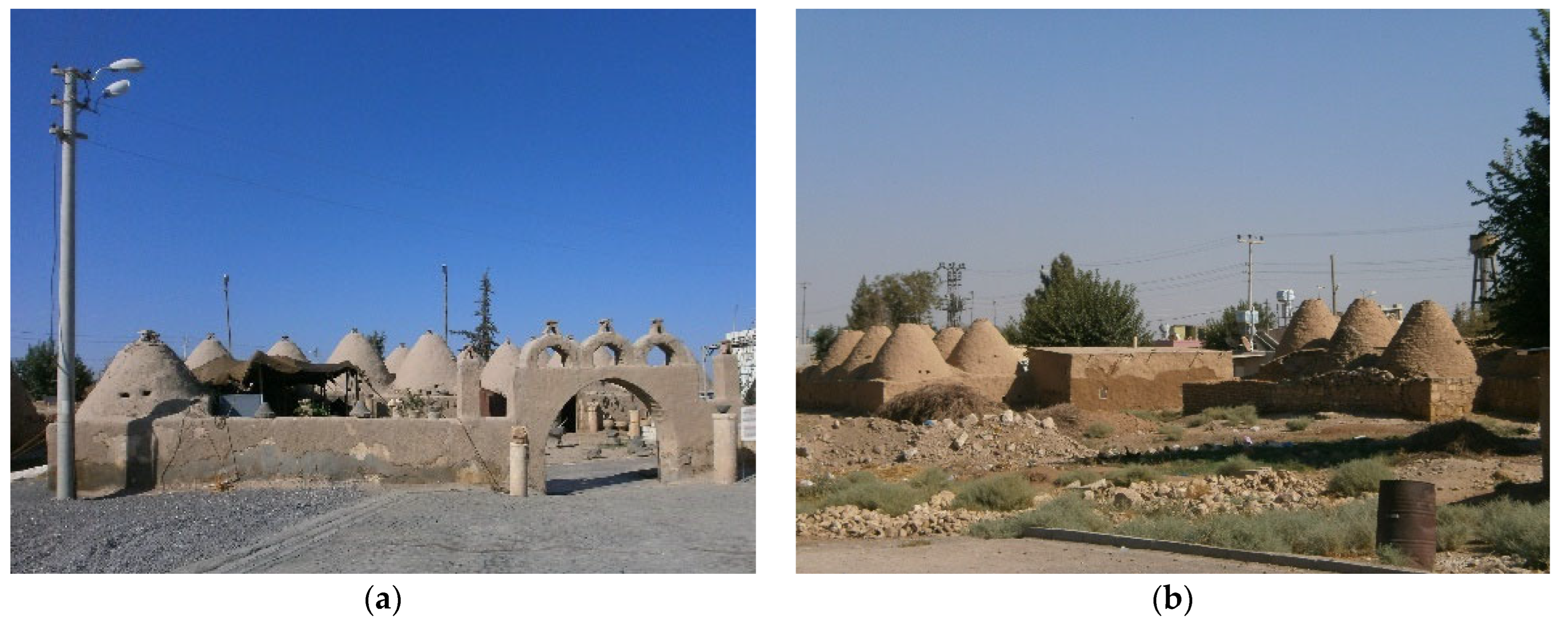
2.1.1. Harran (Şanlıurfa, Türkiye)

The first systematic agricultural activities in southeastern Anatolia are estimated to have begun around 6000 BC. During this period, initial circular settlements emerged in Harran and its surroundings. Sites like Batman-Hallan Çemi, Diyarbakır-Çayönü, and Urfa-Nevali Çori exhibit ground plans and roofing techniques similar to Harran [27]. Additionally, Assyrian stone reliefs dated between 2500 and 600 BC depict architecture resembling Harran’s conic domed dwellings [28]. Excavations show that by 700 BC, Mesopotamian residential buildings combined square plans with courtyard and dome elements [29]. Although present-day Harran domes are approximately 100–200 years old, their roots clearly trace back to Mesopotamian traditions. A 19th-century photograph reveals that earlier domes rose organically from the ground like a tent, while in the 20th century domes were built over square load-bearing walls [30].
Şanlıurfa province, located in southeastern Anatolia, is bordered by Gaziantep to the west, Adıyaman to the northwest, Diyarbakır to the northeast, Mardin to the east, and Syria to the south. The Harran settlement (36°52′ N, 39°02′ E), situated 44 km southeast of Şanlıurfa city, historically connected Europe with Mesopotamia and the Arab world [14]. Located between the Euphrates and Tigris rivers, this geography features plains in the south and mountain ranges in the north. In addition, the arid climate and low vegetation density shaped a unique settlement morphology in Harran.
As a significant center of commerce, culture, and religion in Mesopotamia, Harran attracted various civilizations due to its proximity to fertile lands and its location on major trade routes. Written records from the Assyrian and Hittite periods date the city’s history back to at least 2500 BC, and recent archaeological research suggests even earlier settlements around 8000–10,000 BC [31]. The city’s name, “haran-u” in Sumerian and Akkadian, means “travel” or “caravan,” underlining its function as a hub [32]. Historically, it held geo-strategic importance by linking Babylonia and Assyria with Syria and the Mediterranean. According to biblical and Islamic traditions, Harran is associated with Aran, the brother of the Prophet Abraham, and it was the center of pagan religion in the Assyrian and Babylonian periods [14]. The Moon God Sin and the Sun God Shamash are frequently referenced in Hittite treaties [33] in relation to Harran. During the Abbasid period, Harran became an intellectual center, hosting one of the first Islamic universities. This reputation was lost after the Mongol invasions in the 13th century [34].
Having a bright history and scientific background, Harran has been a city where cultures fused, and it has been equipped with rich architectural and archaeological artifacts (see Figure 1) as it has come under the domination of many states throughout history.
City Walls. It is known that the ditch, located outside of the walls and now filled with soil, was filled with water in the past. In the southeast corner of the city, the walls that were interrupted are replaced by the inner castle. Although the walls of Harran have been destroyed in places, today, they can be observed from all sides. Lloyd et al. [35] drew 6 gates, including Baghdat, Mosul, and Aslanlı Gate at the east, Aleppo Gate at the west, Anadolu (Rum) Gate at the north, and Rakka Gate at the south of the walls. However, Rice [36] added a seventh entrance gate (Niyar) to the city. Only Halep Gate still exists.
Castle. According to Lloyd et al. [35], who made the first survey of the castle in 1951, it must have been built in three periods, which are pre-Islamic times, Islamic times, and the time of al-Malik al-Adil (1192), due to an ornate passage behind the southwest tower.
Mound. Located in the middle of the city, the 22 m height of the mound is spread over a very wide area. The Harran mound, which was inhabited continuously from 7000 BC to the 13th century, contains architectural remains from various periods and documents that will bring the history of the region to light [33]. The first research on the mound started in 1951 [36].
Great Mosque. The Great Mosque, located on the northeastern skirt of the Harran mound, has many other important features, as it is the first monumental mosque of Anatolia, the first mosque with a courtyard and a fountain with a portico, and the richest stone-adorned mosque.
First Age Harran University. The place of the Harran School (University), which has been known since the First Age and reached its peak in science and art between 718 and 913 AD (Islamic period) in the pre-Islamic and Islamic periods, cannot be determined among the ruins today [34]. There is an interpretation that the Ulu Mosque used to be the university. From the Assyrian and Babylonian periods (2000 BC) to the Islamic period (7th century AD), a belief system in which the planets were considered sacred lived in Harran, which shows that the science of astronomy was at an advanced level there. It is known that after the closure of the Athens School by Justinian in 529 AD, the teachers at this school dispersed to the schools in the Al-Jazeera region, which is an intermediate region between Rome and Iran, and Simplicius, one of these teachers, stayed in Harran and tidied up the Harran School [37].
Besides these architectural components, there is other architectural heritage in Harran, including the Hayat-ı Harrani Mosque and Tomb, the Imam Bakir Mosque and Tomb, the Han El Ba’rur Caravanserai, the remains of the Harran East Bazaar and Bath, Hz. Jacob’s Well, the Harran Church, the Small Mosque, and Marvan House.

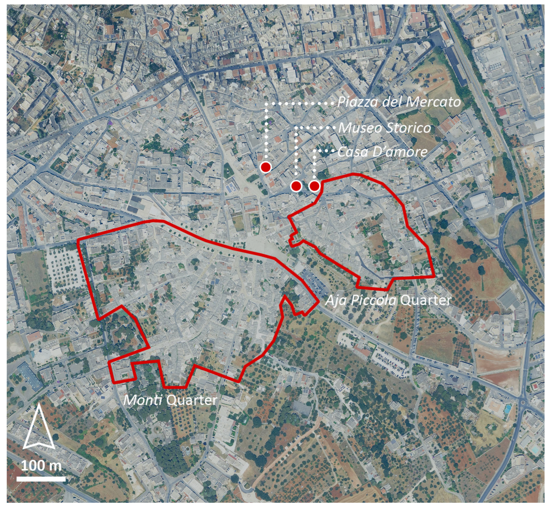
2.1.2. Alberobello (Puglia, Italy)

Alberobello, a village in the Puglia region of southern Italy, is internationally recognized for its unique limestone dwellings known as trulli (trullo singular in Italian). These structures, traditionally built without mortar, feature conical roofs and were used either as temporary or permanent shelters by peasant families [38]. The historical development of Alberobello began in the 17th century and continued uninterrupted until the early 20th century, reflecting a layered urban evolution.
A pivotal date in the town’s institutional history is 1797, when Alberobello was granted the status of a royal city and became an independent municipality. A significant contribution to the understanding of its urban form came with the Regulatory Plan for Expansion developed in August 1883 by architect Antonio Curri [39]. This level of documented urban planning offers a clear framework for tracing Alberobello’s growth—unlike Harran, where the absence of historical regulatory documentation presents challenges for morphological interpretation.
Trulli were traditionally used as multi-functional buildings, housing both families and animals under the same roof. During World War II (1939–1945), some trulli served to host or conceal soldiers [40]. Following the war, many residents transitioned to modern housing, leading to a period of abandonment for several trulli.
Alberobello’s architectural and cultural significance was officially recognized in 1926 when the trulli were declared national monuments. In 1996, the site was added to the UNESCO World Heritage List (see Figure 2) for its outstanding representation of a construction tradition rooted in prehistoric building techniques adapted to a rural context [41].

2.2. Data Collection

This research employs a multi-source data collection strategy combining historical, cartographic, photographic, and field-based materials to construct a comprehensive understanding of the selected case studies. The aim is to trace the morphological evolution of each settlement, understand their typological characteristics, and assess their resilience in the face of environmental and socio-cultural transformations.
For Harran, data were compiled from archaeological excavation reports, historical records, the academic literature, visual archives, and satellite imagery. These sources were complemented by on-site observations, informal conversations, and photographic documentation conducted during field visits in January 2023.
Informal conversations were held with shopkeepers and archaeologists working at the Harran site. Although contact was made with many individuals, the input of only nine participants was ultimately usable. Others were either unwilling to engage, unable to speak Turkish, or did not provide sufficiently detailed responses. Nevertheless, the selected conversations offered valuable contextual insights into vernacular dwelling use, traditional construction techniques, and evolving community practices. In particular, residents’ recollections of past household routines and spatial habits helped support interpretations of internal functional arrangements and validated assumptions about the additive expansion logic of domed units over time. Notes from these conversations were manually recorded by the author during fieldwork.
In addition to this documentation, systematic observations were made regarding environmental and site conditions, such as terrain, water access, local climate, and available materials.
For Alberobello, a combination of archival urban plans, UNESCO reports, historical photographs, postcards, and municipal regulatory documents were reviewed. The Regulatory Plan of 1883 was used as a reference point to evaluate the spatial logics and planning intentions over time. Comparative visual analysis through photographic documentation and literature synthesis provided key insights into the evolution and contemporary management of the trulli typology.

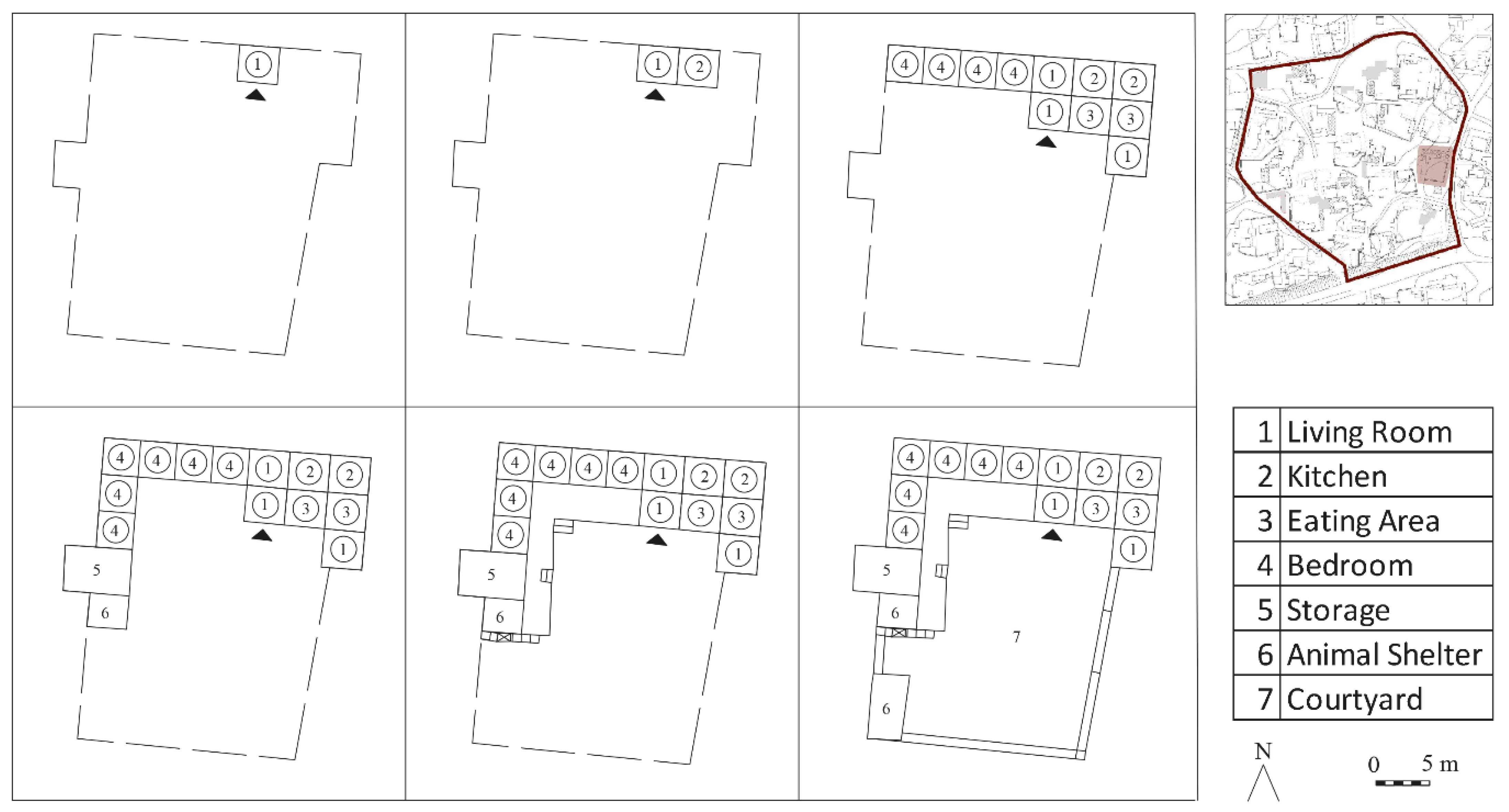
2.3. Typo-Morphological Framework (Compound Scale)

This study employs a typo-morphological approach to investigate the spatial logic and architectural configurations of traditional conic domed settlements. The method follows the principles of the Italian school of urban morphology, particularly the foundational work of Saverio Muratori and Gianfranco Caniggia, which interprets the built environment as a result of historical processes of transformation and aggregation [43,44]. The analysis pays close attention to the formal, functional, and spatial relationships between individual building units, the domestic courtyard, and their integration into the wider settlement structure.
In the case of Harran, a comprehensive examination of vernacular domed dwellings was carried out through architectural plans, archival photographs, fieldwork documentation, and the scholarly literature. Typological reading of the domed compounds was developed to classify recurring unit types based on their function, form, and spatial relationship within the compound. This typological framework is grounded in previous fieldwork [45] and further elaborated in Section 3.2, building on the operational principles of Muratori and Caniggia. It serves to bridge abstract morphological theory with vernacular architectural realities, enabling the practical application of typo-morphology as both an analytical and interpretive tool.
In addition to architectural documentation, particular attention was paid to the environmental setting of the selected compound. During field visits, systematic observations were made regarding terrain, water access, microclimatic conditions, and material availability. The compound’s location on flat land enabled the horizontal expansion of domed units around a central courtyard. Access to water through private wells and the use of locally sourced adobe and reclaimed materials were key in shaping construction logic. Although no formal environmental modeling was applied, these site-based observations supported the interpretation of morphological patterns as pragmatic responses to climatic and topographical constraints.
Typological distinctions were drawn based on unit function (e.g., living room, kitchen, storage, barn), form (e.g., single dome, double dome), and spatial arrangement (e.g., linear, L-shaped, U-shaped clusters) [45]. The transformation of these domed units into compound dwellings around courtyards was analyzed to understand organic growth patterns and adaptation to environmental and socio-cultural needs.
The selection of the compound for hypothetical, detailed analysis was based on three main criteria: (1) the presence of a relatively large number of interconnected domed units, which allowed for a meaningful reading of additive spatial logic; (2) physical accessibility for field observation; and (3) the opportunity to engage in informal conversations with residents, which provided valuable insights into spatial usage and historical transformations. These criteria ensured that the selected compound could support both spatial and ethnographic interpretations within the typo-morphological framework.
The analysis at the compound scale focused on a representative historic compound within Harran’s walled core. The selected parcel spans approximately 945 square meters, originally comprising 13 domed units, of which only 4 remain today. The configuration includes 555 square meters of open courtyard space, which served as the social and functional heart of the dwelling. This micro-scale reading provided key insights into the logic of additive growth and the spatial arrangement of vernacular domestic life, forming the foundation for broader morphological interpretation.
This study also explored how parameters, such as family size, lifestyle, and material availability, influenced the morphological evolution of domestic forms. Special emphasis was placed on the role of the courtyard as the spatial and social core of each household and how nomadic heritage translated into permanent architectural expression. The resulting typological model illustrates the progressive aggregation of domed units, from individual cells to complex family compounds.
This selection represents a purposive sampling strategy aimed at capturing a typical and information-rich compound for in-depth typo-morphological interpretation, rather than statistical representativeness.

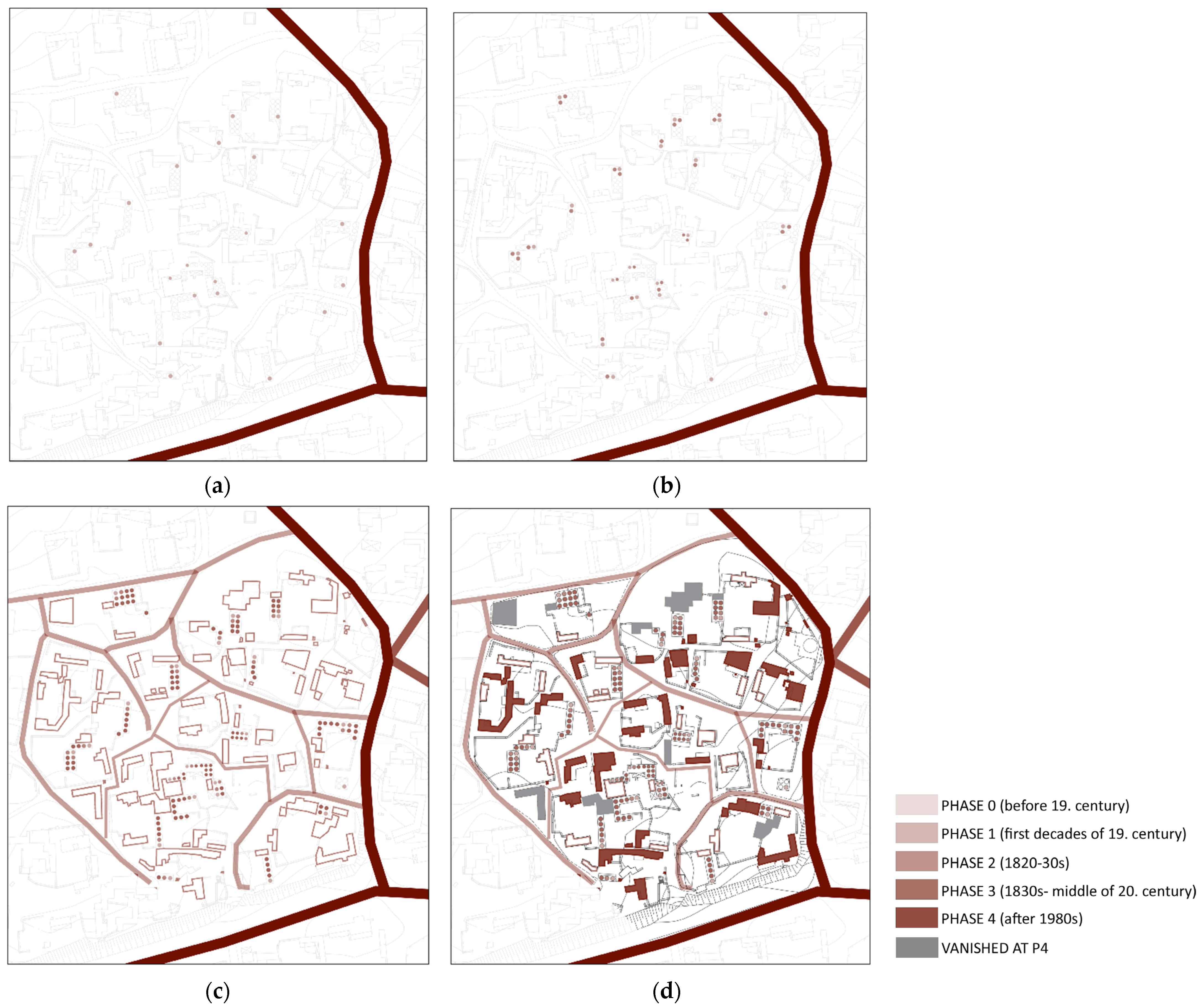
2.4. Expansion Analysis (District and Town Scales)

To explore the morphological transformation of Harran’s built environment over time, a phase-based expansion analysis was conducted. This approach allowed for the identification of distinct development stages within the historical settlement. The analysis was based primarily on visual and spatial interpretation of historical maps, archival photographs, field observations, and the scholarly literature. While no detailed cadastral or planning documents exist for earlier periods, the physical traces of the settlement’s growth, such as organic street patterns, dome aggregations, and courtyard layouts, provided the foundation for reconstructing phases of expansion, followed by informal communication with the local people.
It is important to note that this reconstruction remains hypothetical, built on a combination of morphological reasoning and indirect historical evidence. Nevertheless, the framework offers a coherent narrative of how the settlement might have evolved in response to social organization, environmental conditions, and material practices.
The selection of the district-scale area was informed by a combination of prior research familiarity and new morphological observations. Specifically, the southern fringe of the previously studied area [45] was excluded, while a northern area was incorporated based on the emergence of clearer aggregation patterns and a higher concentration of surviving domed dwellings. This area was also chosen for its proximity to key heritage sites, such as the Culture House and the castle, which made it more vital and logistically feasible for fieldwork, in contrast to more isolated or sparsely populated areas.
At the town scale, the entire historical core within the city walls was included to allow for a comprehensive reading of the larger-scale spatial logic and expansion dynamics of the settlement.
To capture the transformation of Harran’s built environment across scales, the expansion analysis was conducted at both district and town levels. At the district scale, a compact portion of the walled core was selected, encompassing approximately 44,725 square meters. This area was chosen due to its dense concentration of vernacular domed dwellings and its visible patterns of aggregation over time. At the town scale, two contiguous sectors of the settlement, measuring 334,175 and 52,286 square meters in the south and the northeast, respectively, were mapped to illustrate the spatial logic of expansion beyond the fortified center. These areas collectively fall within Harran’s historical walled core, which spans a total surface of approximately 1.11 ha. The use of multi-scalar mapping supported the reconstruction of sequential growth phases and allowed for a diachronic interpretation of spatial transformation.
Overall, the selection at both the district and town scales also followed a purposive sampling logic, designed to include the most morphologically significant and accessible areas within the historic core while enabling a coherent diachronic analysis of spatial transformation.
The selected district within the city walls was mapped to represent these phases diagrammatically, capturing key moments from the earliest known occupation (Phase 0) to current heritage-led interventions (Phase 4). Each phase corresponds to significant changes in settlement logic, family structure, functional needs, and external influences (e.g., socio-economic shifts, infrastructure projects, and policy interventions). The diagrams and the photographs represented in the Section 3.3 synthesize these spatial transformations, offering a narrative of how vernacular growth patterns evolved from individual dome units to compact clusters and eventually to partial abandonment and preservation efforts.
The identification of development phases was based on a set of morphological criteria, including changes in aggregation patterns, spatial arrangement (e.g., the emergence of courtyards), construction typologies, and functional differentiation. These criteria were interpreted through diachronic comparisons of historical maps and satellite imagery available in different years, and they were further cross-referenced with oral histories and the academic literature, where feasible. The triangulation of visual analysis, archival sources, and local testimonies provided a coherent interpretative framework. Although qualitative in nature, this multi-source validation approach ensured consistency in delineating expansion phases and helped mitigate subjectivity in assigning temporal boundaries.

3. Results and Discussion

The walled historic core of Harran covers approximately 111 ha, making it significantly larger than comparable heritage settlements, such as Alberobello (10.2 ha), which underscores both the scale and complexity of its traditional urban fabric.

3.1. Methodological Discussion

The present study adopts a typo-morphological approach to analyze the evolution and conservation of vernacular-built heritage in two distinct case studies, i.e., Harran and Alberobello. This method, grounded in the traditions of urban morphology, enables the identification of spatial logics, building typologies, and growth patterns that shape the historic character of settlements. As highlighted in the work of Saylan and Gürer [46], typo-morphology offers a robust framework and practice for deciphering the contextual layers of a built environment, thereby supporting informed design decisions and conservation strategies.
This approach is particularly relevant in contexts where written documentation is sparse and physical form serves as a primary historical record. The analysis of spatial configurations over time, supported by diachronic mapping and base maps derived from surveys, aligns with similar studies, such as the one by Lu et al. [47] in Guangzhou. There, typo-morphological assessments were effectively used to understand how traditional dwelling forms adapted to pressures of urbanization while preserving cultural identity.
Moreover, the integration of typological and morphological data with participatory or community-informed sources, such as Volunteered Geographic Information (VGI), has shown promise, especially in underrepresented rural contexts. The method adopted by Perner and Svenningsen [48] for reconstructing historical addresses through aerial photographs and VGI in Denmark demonstrates how hybrid datasets can complement traditional survey-based morphology to re-establish lost urban legibility.
The presented analysis of Harran’s domed dwellings heavily relied on indirect sources and spatial inference due to the scarcity of restoration records or formal typological plans, underscoring the methodological challenge often faced in marginalized or peripheral heritage sites. This issue resonates with another study [5] on spatial perception, which suggests that the sensory and experiential dimensions of vernacular morphology must be acknowledged, especially when planning for conservation or adaptive reuse. In such contexts, perceptual continuity is as critical as physical preservation.
Together, these studies affirm the suitability of typo-morphological analysis for capturing both the form and meaning of vernacular heritage. However, its implementation is context-dependent and often limited by data availability, interpretive biases, and institutional support. The methodological pathway in this paper attempts to navigate these constraints through a composite strategy integrating visual survey, archival base maps, regulatory overlays, and sequential diagramming to construct a plausible narrative of spatial transformation while also drawing comparative insights from the legally and technically more established case of Alberobello.

3.2. Typo-Morphological Framework (Compound Scale)

The domed dwellings (also known as Harran houses and beehive houses and kümbet ev in Turkish) of Harran represent a spatial logic that emerges from daily life, familial growth, environmental adaptation, and material constraints. Rather than fixed architectural typologies, these houses evolve incrementally, beginning with a single domed unit and extending over time into clustered compositions organized around an internal courtyard, as in the two examples shown in Figure 3 below.
As shown in Figure 4, the first unit is typically a living room (1), functioning as the main family space and occasionally shared with animals during cold seasons. As needs grow, additional units are added; a kitchen (2), often used in colder months as a warm sitting area, and a modest eating area (3) are introduced next. Over time, specialized bedrooms (4) are included, reflecting increasing spatial differentiation as family life becomes more crowded after marriage [45].
The growth of the unit continues with the construction of dedicated storage rooms (5) and animal shelters (6), often attached as flat-roofed or semi-open volumes depending on material availability and terrain. Eventually, a courtyard (7) is formed—either intentionally or as a by-product of this aggregation—serving as the central space for cooking, socializing, resting, and seasonal outdoor sleeping. The courtyard often includes a well for water needs. It may also feature a wooden terrace-bed taht (literally, throne) or a goat-hair tent used for shade and dairy production, as shown in Figure 5a,b, respectively.
More than functional additions, these courtyard elements embody Harran’s vernacular response to climate and social life. The wooden terrace-bed, a raised wooden platform traditionally used for outdoor sleeping during hot summer nights, represents both comfort and familial intimacy. Often referred to as a “throne,” it functions as a seasonal bed and a communal resting space, reinforcing family cohesion through shared routines under the open sky [49]. The goat-hair tent, typically erected within the courtyard during warmer months, provides shaded space for daytime activities, such as food preparation, dairy production, and social gatherings. Beyond their functional roles, both structures reflect a continued nomadic legacy within settled domestic life, offering architectural flexibility, climatic adaptability, and symbolic continuity. Their integration into the spatial core of the household illustrates the dynamic interplay between permanent architecture and temporary, mobile elements in Harran’s traditional compounds.
The spatial arrangement of the compound reflects pragmatic adaptation to Harran’s environmental context. Situated on flat terrain, the compound could expand horizontally around a central courtyard, which typically housed a well to meet daily water needs. The buildings, made of adobe and brick sourced from local ruins, reflect both material scarcity and cultural continuity. The corbelled domes, constructed without wood due to their absence in the region, are optimized for Harran’s extreme climatic conditions, offering thermal insulation against summer heat and retaining warmth in winter. The top openings in the domes serve for ventilation and daylighting while functioning as chimneys in colder months. Seasonal elements like the wooden terrace-bed and goat-hair tent further illustrate architectural responsiveness, as they provided shade, comfort, and productive space for dairy processing during summer. As supported by prior field studies, these design choices demonstrate how vernacular architecture in Harran evolved through an intimate understanding of site-specific environmental constraints and cultural practices.
Architecturally, the dome is constructed in a conical form, built over a square base using squinches and pendentives. Each dome reaches up to 5 m in interior height and consists of approximately 30–40 mudbrick layers. The spatial sequence does not follow a pre-defined plan but arises from family dynamics, building know-how, and functional needs. While some families use arches to connect domed units or curtains for flexibility, others leave passageways open, leading directly to the courtyard [13].
The clustered layout of Harran’s courtyard-based houses results from the settlement patterns of extended families and tribal affiliations. This dense morphology reflects not only social organization but also environmental adaptation and agricultural lifestyles. As illustrated in Figure 4, the evolution from a single domed unit to multifunctional compounds reveals a gradual, need-driven transformation. Each spatial addition responds to functional requirements while embedding cultural practices into the built form. These aggregated units collectively define the unique typo-morphological identity of Harran.

3.3. Expansion Analysis of the Settlement (District and Town Scales)

The spatial evolution of Harran’s urban fabric, similar to the building shape, has occurred through an organic, unplanned process shaped by topography, tribal customs, and evolving domestic needs. Access to the historical city is currently provided through the remaining gates, once part of a fortified wall system. This axis leads toward a central square where key architectural landmarks, such as the castle and the mosque, are located, branching off into narrower streets and clusters of domed dwellings.

3.3.1. District Scale

These housing groups are closely built within the city walls and open onto a network of irregular paths and small squares. These public spaces have largely formed as residual voids between constructions, rather than as planned civic structures. Despite its rich historical and architectural heritage, the historic settlement lacks modern infrastructure, such as markets, service units, and public amenities. The spatial layout of Harran reflects a layered development, not governed by formal planning but by cultural, environmental, and economic factors.
Domed housing clusters emerged organically, connected through narrow pedestrian paths shaped by the built environment rather than predefined routes (see Figure 6). This morphology is reflective of a living tradition grounded in tribal social organization and subsistence practices.
The evolution of Harran’s pedestrian network reflects not only organic spatial growth but also deep-rooted tribal and familial structures. In early phases, as illustrated in Figure 6a,b, housing units clustered in tight kin-based compounds, with paths emerging informally between them. Over time (Figure 6c,d), these footpaths evolved into a web with curved connections, prioritizing internal cohesion and privacy over permeability or hierarchical structuring. This pattern is consistent with observations from tribal urbanism in the broader Near Eastern context. Whitcomb [50] notes that in early Islamic Syria, tribal settlement clusters preserved internal egalitarian logic and reinforced group identity through courtyard-centered housing and dense spatial arrangements that mirrored tribal affiliations. Similarly, van der Steen [51] describes how tribal societies often maintained proximity between lineage segments in a way that directly influenced spatial distribution, path creation, and the informal logic of nodal spaces. In Harran, the cumulative result is a spatial system shaped by negotiated boundaries, shared use areas, and paths that follow social rather than geometric order—an urban expression of tribal belonging and relational proximity.
Figure 7 below offers a diachronic visualization of Harran’s morphological evolution, structured according to the color-coded phases outlined in the legend. In Figure 7a, the current layout of the settlement is shown, including key landmarks, e.g., the Great Mosque, the mound, and the castle, as they were built before the 19th century, defined as Phase 1. Figure 7b introduces Phase 1, where the area around the castle in particular represents the core vernacular fabric where domed units begin to cluster. Figure 7c expands to include Phase 2, tracing the spatial growth of the settlement into the later 19th and 20th centuries.
Phases 3 and 4, visible at the district scale (see Figure 6), highlight the progressive outward expansion, including developments beyond the city walls, as well as areas that later vanished or were abandoned (gray tone) during the transformation processes after the 1980s. Together, Figure 6 and Figure 7 visually reconstruct the settlement’s layered growth and set the foundation for the more detailed phase mapping at the district and town scales, respectively.

3.3.2. Town Scale

To better understand the settlement’s growth, a phase-based expansion model was constructed, grounded in historical data, archival imagery, field observation, and morphological interpretation. Five key phases of development were identified (see Figure 7).
Phase 0: Represents the historical foundation of Harran, encompassing pre-Islamic and early Islamic urban configurations. Dated as early as 7000 BC, the settlement was established on trade routes linking central Anatolia and the Mediterranean. Archaeological remains from 3000 BC to the 13th century indicate a layered history of courtyard houses, narrow streets, and functional urban logic characteristic of early Islamic cities.
Phase 1: Marks the construction of domed dwellings approximately 150–200 years ago, primarily in the southeast quadrant of the walled city. This area was likely chosen for its proximity to the castle, a source of construction materials, and its relatively flat terrain. Each compound typically began with a single multi-functional dome, which included most daily living functions aside from sanitation.
Phase 2: Reflects the addition of new domed units to accommodate expanding families. There were no fixed rules—new units were simply added where space permitted. Because most residents belonged to the same extended family or tribal group, privacy was not a major concern, and dwellings were built as close together as possible. This phase marked the beginning of the dense, compact urban fabric seen today.
Phase 3: Illustrates the development of functional differentiation and spatial arrangement. Courtyards began to structure the layout, echoing models seen in other vernacular settlements like Alberobello. While Alberobello followed planned street alignments, Harran’s layout remained fully organic. In this period, new units were also built to shelter animals or store agricultural goods, reflecting the increased practice of transhumance.
Phase 4 (ongoing): This phase refers to heritage-focused interventions following Harran’s designation as an archaeological and urban conservation site in 1979, when 960 domed dwellings existed [52]. However, this number most likely refers to individual domes rather than entire dwelling compounds composed of multiple domes. In the local context, a single dome is sometimes referred to as a “home,” which has historically caused confusion in official records.
Following this designation, government regulations prohibited the reuse of historic brick and discouraged new construction within the protected area. These limitations, combined with broader socio-economic changes, such as the construction of the Atatürk Dam in 1989 and the implementation of the Southeastern Anatolia Project (GAP) in the 1990s [53], spurred a shift from nomadic herding to irrigated agriculture. Rising living standards and access to modern amenities led families to relocate to a nearby settlement with concrete houses and improved infrastructure. By the mid-1990s, most residents had left the historic core, leaving the traditional domed compounds largely abandoned.
This exodus disrupted domestic and social rhythms tied to architecture. Activities like cooking, resting, and seasonal maintenance, such as dome replastering with mud, straw, or rose petals, faded into symbolic acts. The domes, once homes, now stand as heritage relics. By 2019, only one traditional dome-builder remained, with his apprentice lamenting the lack of institutional support: “Because these houses are not used, their repair and upkeep isn’t done and they collapse…” [54].
Despite this cultural dislocation, adaptive reuse has emerged as a promising strategy. Beginning in the late 1990s, some domed dwellings were preserved and repurposed for tourism and cultural use. The Harran Culture House, restored in 1999, now functions as a combined museum, café, and restaurant [55]. Other domes have become souvenir shops run by local women, supporting both livelihoods and cultural continuity [13,30,52,56].
By 2013, the number of remaining domes was estimated at around 500 [57], although, again, this likely refers to individual dome units rather than full dwellings. By 2016, within the boundaries of the Management Plan Area, a total of 110 conical domed dwellings (kümbet) had been officially registered as civil architectural heritage [58].
These adaptive reuse efforts reflect what Jiao et al. [47] describe as essential efforts for sustaining historical urban form, including not just physical preservation but socially embedded functions. While curated spaces may not restore the original way of life, they offer a viable path for keeping Harran’s typo-morphological identity alive within a contemporary context.

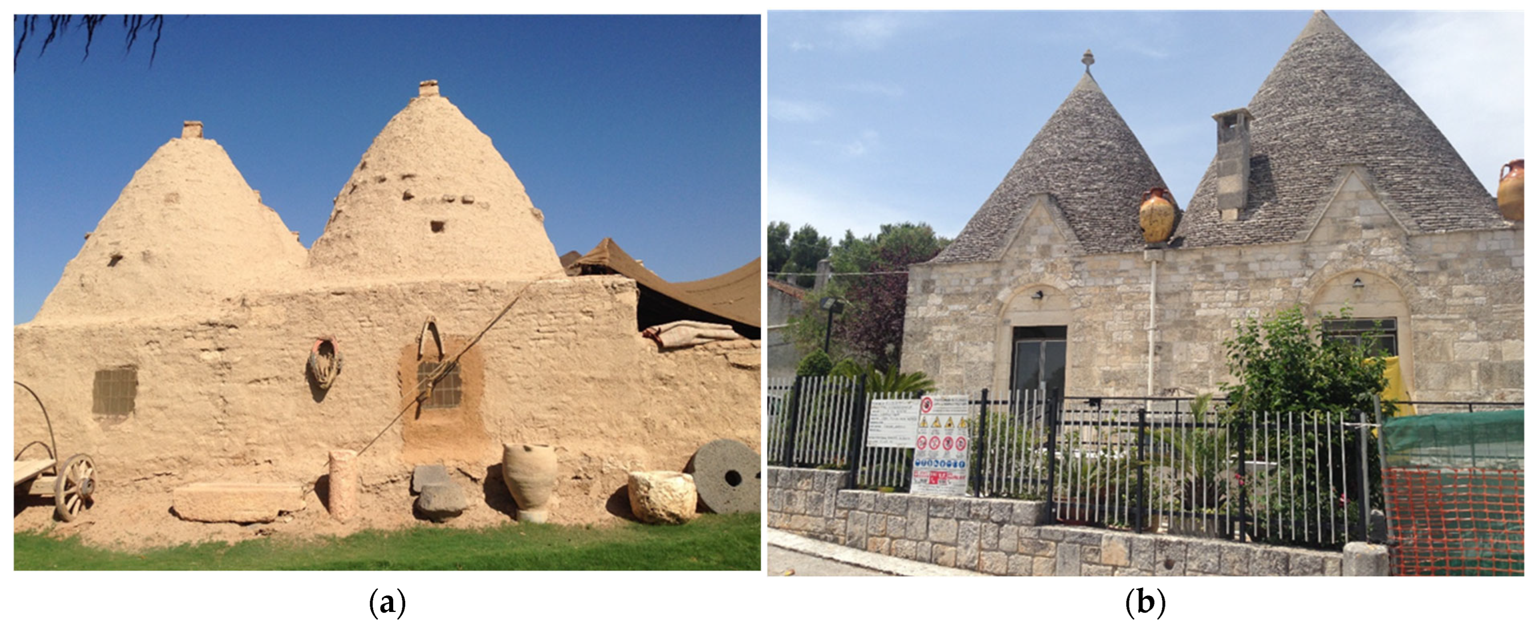
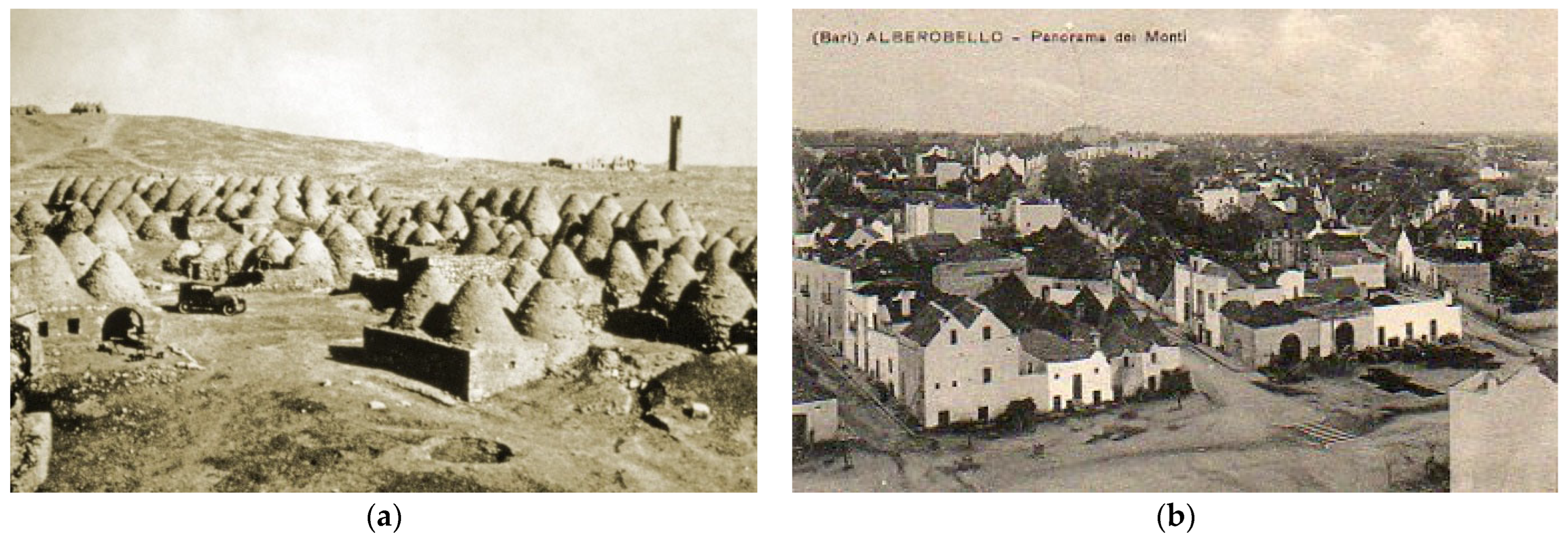
3.4. Reflections from Alberobello

The case of Alberobello provides critical insights for interpreting and contextualizing the typo-morphological evolution of Harran. Although these settlements differ significantly in climate, materials, and historical trajectory, they share striking similarities in architectural form, growth logic, and socio-cultural underpinnings.

3.4.1. Morphological Similarities and Divergences

Both Harran and Alberobello evolved through the aggregation of modular conic units (see Figure 8) around shared open spaces. In Alberobello, the trulli were originally constructed without mortar, using local limestone and corbelled roofing techniques. Similarly, Harran’s domed dwellings were built with adobe bricks laid in a stepped, circular fashion on square bases, also without modern mortar techniques [45,59]. In both contexts, typological evolution began with a core unit (often a living space) and expanded incrementally based on family needs, with new domes added for cooking, storage, sleeping, or animals. This organic and additive growth is well-documented in both cases and closely tied to family structure and land availability [38,60].
The urban fabric of Alberobello, while similar in logic, followed a more legible sequence influenced by the site’s topography and water canal routes, which structured the layout [60]. In contrast, Harran’s pattern was defined more by tribal proximity, flat topography, and pragmatic spatial adaptations. For example, while Alberobello’s trulli were gradually formalized into a regulated and monumentalized urban core—eventually supported by planning instruments—Harran’s morphology remained spontaneous and was shaped primarily by user appropriation and subsistence practices.
As shown in Figure 9, both Harran and Alberobello exhibit a dense and clustered urban fabric derived from the repetition and aggregation of conic units. Yet while Harran’s organic layout reflects spontaneous tribal settlement, Alberobello’s grid-like pattern indicates stronger external regulation, even in early phases.
A major point of divergence is institutional support and conservation trajectory. Alberobello was declared a national monument in 1926 and recognized by UNESCO in 1996 [41]. Its planning history includes the 1883 Regulatory Plan by Antonio Curri, which formalized the settlement’s logic and ensured the survival of its unique identity [40]. In contrast, Harran’s conservation history has been reactive. Although the settlement was declared an urban and archaeological site more than four decades ago, interventions have been scattered and often lacked continuity, as evidenced by the uncontrolled concrete development outside of the historic walls [45]. On the other hand, Harran has been on the tentative World Heritage list of UNESCO since 2000 [62]. Despite the differences discussed above, the symbolic alignment between the two towns has become more tangible since a sister city protocol was signed [26]. This cultural diplomacy highlights the potential for knowledge exchange, as Harran can draw valuable lessons from Alberobello’s experience in institutional protection, adaptive reuse, and integration into tourism circuits.
Lastly, Alberobello’s case demonstrates how vernacular settlements can be reframed as living heritage, not as frozen artifacts but as adaptive, evolving environments. For Harran, which is currently at risk of depopulation and architectural loss, this offers a vital roadmap. Strategies, such as community-led restoration, establishment of clear regulatory frameworks, and the promotion of agri-cultural tourism, can help align conservation with local livelihoods, ensuring that its morphological and cultural layers are not only documented but sustained.

3.4.2. Legal and Institutional Reflections

Although Harran and Alberobello share significant morphological affinities, their legal and institutional frameworks for heritage conservation differ markedly. Alberobello has long benefited from a robust, multi-level protection system. Following its designation as a national monument in 1926 and UNESCO World Heritage inscription in 1996, the town operated under the World Heritage Convention (1972), with policies aligned to the Venice and Burra Charters. The 2011 UNESCO Management Plan clearly defines responsibilities across local, regional, and national levels, ensuring authenticity, integrity, and community involvement. This framework is further supported by Italy’s heritage code (Codice dei Beni Culturali, D.Lgs. 42/2004) and Puglia’s Regional Law No. 72/1979, which enabled early restoration efforts and continue to attract EU funding.
Harran, in contrast, has been under national protection since 1979 (Phase 4) through Türkiye’s Law No. 2863 on the Conservation of Cultural and Natural Assets, and it was added to the UNESCO Tentative List in 2000. Although recent instruments, such as the 2009 and 2024 Conservation-Oriented Master Plans, reflect growing adherence to ICOMOS principles (e.g., authenticity, minimal intervention, participatory methods), governance remains fragmented. Conservation efforts are primarily state-driven, with limited local capacity, enforcement, or stable funding mechanisms.
In particular, the vernacular character of Harran’s built fabric aligns with the ICOMOS Charter on the Built Vernacular Heritage [63], which highlights the importance of safeguarding not only the physical form but also the cultural processes and traditional knowledge systems that shape it. The typo-morphological evolution of Harran’s domed compounds reflects such vernacular logic—emerging from community practices and adaptive responses to the environment and use—yet current conservation policy still lacks mechanisms to sustain this continuity.
To advance toward full UNESCO inscription and long-term resilience, Harran will require institutional strengthening, coordinated stakeholder engagement, and a sustainable, community-inclusive management system.

4. Conclusions

The vernacular settlement of Harran is composed of clustered houses built with adjacent domed units, varying in number from two to six or more per compound. These dwellings are organized around courtyards and incorporate spaces for storage and animal shelters. Constructed using mixed materials, they emerged from tribal traditions; families of the same lineage preferred to live in proximity, resulting in dense urban clusters and organically formed street networks. The transition from nomadic life to settled agriculture further shaped this morphology, aligning form and function with productivity and livestock needs.
This research aimed to decipher Harran’s rural architectural heritage by tracing its typo-morphological formation across multiple scales, from individual units to the broader urban fabric. Despite limited historical documentation and a general lack of conservation awareness, the spatial logic of the settlement reveals a coherent system embedded within cultural and environmental continuity.
Theoretically, the study contributes to the growing field of vernacular conservation by demonstrating how typo-morphological analysis can reconstruct settlement logic even in data-scarce environments. It also affirms the value of visual reconstruction and comparative frameworks for identifying spatial heritage patterns beyond written records in rural areas.
The domed structures of Harran resonate with broader architectural patterns found across Mesopotamian and Mediterranean Neolithic cultures. Despite their historical significance, most of these buildings have been abandoned over recent decades, with many used only as barns or warehouses. Since the 1980s, residents have relocated to a nearby settlement, intensifying the risk of cultural extinction.
To address this, urgent and multi-scalar interventions are needed. First, awareness and education about appropriate usage and maintenance must be strengthened among both local communities and authorities. Improper plastering and poor restoration techniques have accelerated structural degradation. Second, coordinated and well-funded conservation policies should be implemented at both local and national levels. In this regard, Alberobello’s trulli offers a compelling model, as strong legal protections, financial incentives, socio-economic revitalization, community-led repurposing, and adaptive reuse strategies have ensured their long-term survival as both cultural symbols and economic assets.
Adaptive reuse, when approached beyond surface-level restoration, holds transformative potential for integrating vernacular heritage into sustainable tourism ecosystems. In the case of Harran, however, such initiatives remain fragmented and underutilized, lacking a coherent vision that aligns cultural continuity with local development. To move forward, adaptive reuse must be reimagined not merely as a conservation tactic but as a community-driven strategy for revitalizing socio-spatial heritage through participatory tourism models and long-term place stewardship.
Unlike Alberobello, which benefits from a clearly defined multi-level governance system and strong local engagement, Harran’s institutional landscape remains fragmented and top–down. Residents are often excluded from planning processes, and tourism engagement is limited to surface-level experiences. A resilient conservation model for Harran will require inclusive governance, sustainable investment/funding, stronger public–private–community partnerships, and dedicated heritage management mechanisms.
This research has limitations due to the absence of quantitative data, as this constrains the precision of spatial inference. The methodology relies on interpretive mapping due to scarce longitudinal documentation, which may introduce subjectivity, despite efforts to reduce it using multiple sources, such as archival maps, satellite imagery, oral histories, and field observations.
Future research could adopt a mixed-methods approach, combining qualitative typo-morphological reading with GIS-based modeling, socio-economic datasets, and participatory mapping to support a more holistic and operational perspective on rural heritage sustainability. Additionally, more detailed phasing could be developed if new sources become available.

Funding

This research received no external funding.

Data Availability Statement

The data presented in this study are available on request from the author.

Conflicts of Interest

The author declares no conflict of interest.

Abbreviations

The following abbreviations are used in this manuscript:
ADAnno Domini
BCBefore Christ
EEast
HaHectare
GAPGüneydoğu Anadolu Projesi—Southeastern Anatolian project
ICOMOSInternational Council on Monuments and Sites
MwMoment Magnitude (used for measuring earthquake magnitude)
NNorth
UNESCOUnited Nations Educational, Scientific and Cultural Organization
VGIVolunteered Geographic Information
kmKilometer

References

  1. Cataldi, G.; Maffei, G.L.; Vaccaro, P. Saverio Muratori and the Italian School of Planning Typology. Urban Morphol. 2002, 6.1, 3–14. [Google Scholar] [CrossRef]
  2. Maretto, M. View of the Early Contribution of Saverio Muratori: Between Modernism and Classicism. Available online: https://journal.urbanform.org/index.php/jum/article/view/3970/3343 (accessed on 8 June 2025).
  3. Samoná, G. Tradizionalismo Ed Internazionalismo in Architettura. Rass. Di Archit. 1929, 2, 459–466. [Google Scholar]
  4. Strappa, G. Reading the Built Environment as a Design Method. In Urban Book Series; Teaching Urban Morphology; Oliveira, V., Ed.; Springer: Berlin/Heidelberg, Germany, 2018; pp. 159–184. [Google Scholar]
  5. Stojanovski, T.; Axelsson, Ö. Typo-Morphology and Environmental Perception of Urban Space. In Proceedings of the ISUF 2018 XXV International Conference: Urban Form and Social Context: From Traditions to Newest Demands, Krasnoyarsk, Russia, 5–9 July 2018. [Google Scholar]
  6. Gugliotta, R. Reading Morphology Through Diagrams. Exploring Methodology. In Proceedings of the 6th ISUFitaly International Conference: Morphology and Urban Design—New Strategies for a Changing Society, Bologna, Italy, 8–10 June 2022; pp. 334–343. [Google Scholar]
  7. Strappa, G. Urban Morphology Following the Muratorian Tradition. “DeğişKent” Değişen Kent, Mekân ve Biçim Türkiye Kentsel Morfoloji Araştırma Ağı. In Proceedings of the II. Kentsel Morfoloji Sempozyumu, Istanbul, Turkiye, 31 October–2 November 2018. [Google Scholar]
  8. Habib, A.I.; Koren, A.S.A.; Hassan, G.F.; El Fayoumi, M.A.; Afifi, S.Z. Urban Morphology Schools of Thoughts; A Holistic Overview. YMER 2024, 22, 747–768. [Google Scholar]
  9. Bechlem, R.; Djouad, F.-Z.; Salah-Salah, H. Morphological Analysis of Public Spaces and Their Contribution to Urban Resilience in Guelma, Algeria. J. Mediterr. Cities 2024, 4, 167–177. [Google Scholar] [CrossRef]
  10. Salvati, A.; Monti, P.; Coch Roura, H.; Cecere, C. Climatic Performance of Urban Textures: Analysis Tools for a Mediterranean Urban Context. Energy Build 2019, 185, 162–179. [Google Scholar] [CrossRef]
  11. Sammarco, C. The Substrate and Urban Transformation. Rome: The Formative Process of the Pompeo Theater Area. J. Contemp. Urban Aff. 2019, 3, 1–7. [Google Scholar] [CrossRef]
  12. Tunca, Ö.; Rutten, K. The Corbelled Dome in the Archaeology of the Ancient Near East. In Earthen Domes et Habitats. Villages of Northern Syria an Architectural Tradition Shared by East and West; Mecca, S., Dipasquale, L., Eds.; Edizioni ETS: Pisa, Italy, 2009; pp. 33–39. [Google Scholar]
  13. Sami, K.; Özdemir, İ. The Vernacular Houses of Harran and Cultural Heritage-Turkey. Int J Acad Res 2011, 3, pp.148–151. [Google Scholar]
  14. Dizdar, S.İ. Urfa-Harran Houses and Living Spatial Places. Int. J. Curr. Res. Rev. Technol. 2017, 17, 46–58. [Google Scholar]
  15. Günkut, A. Geleneksel Harran Evleri. In Yurt Ansiklopedisi, Cilt.10; Anadolu Yayıncılık: Istanbul, Turkiye, 1984. [Google Scholar]
  16. Lloyd, S. The Archaeology of Mesopotamia: From the Old Stone Age to the Persian Conquest; Thames & Hudson: London, UK, 1978; p. 252. [Google Scholar]
  17. Rovero, L.; Tonietti, U. A Modified Corbelling Theory for Domes with Horizontal Layers. Constr Build Mater 2014, 50, 50–61. [Google Scholar] [CrossRef]
  18. Cygielman, M. Tholos Tombs in Etruria. In Earthen Domes et Habitats. Villages of Northern Syria an Architectural Tradition Shared by East and West; Mecca, S., Dipasquale, L., Eds.; Edizioni ETS: Pisa, Italy, 2009; pp. 51–62. [Google Scholar]
  19. Vegas, F.; Mileto, C.; Cristini, V. Corbelled Dome Architecture in Spain and Portugal, Earthen Domes And Habitats. In Earthen Domes et Habitats. Villages of Northern Syria an Architectural Tradition Shared by East and West; Edizioni ETS: Pisa, Italy, 2009; pp. 81–89. [Google Scholar]
  20. Ghobadian, V. Climatic Analysis of the Iranian Traditional Buildings; Tehran University Publications: Tehran, Iran, 1998. [Google Scholar]
  21. Niroumand, H.; Jamil, M.; Zain, M.F.M. The Earth Refrigerators as Earth Architecture. Int. J. Environ. Sci. Dev. 2012, 3, 315–318. [Google Scholar] [CrossRef]
  22. Arakadaki, M. Corbelled Dome Architecture in Greece. In Earthen Domes et Habitats. Villages of Northern Syria an Architectural Tradition Shared by East and West; Edizioni ETS: Pisa, Italy, 2009; pp. 97–110. [Google Scholar]
  23. Dipasquale, L.; Devaux, E. The Urban Morphology of Dome Villages. In Earthen Domes et Habitats. Villages of Northern Syria an Architectural Tradition Shared by East and West; Edizioni ETS: Pisa, Italy, 2009; pp. 257–266. [Google Scholar]
  24. Chang, P.-C.; Swenson, A. Construction|History, Types, Examples, & Facts. Available online: https://www.britannica.com/technology/construction (accessed on 8 June 2025).
  25. Ölçer, S.; Önal, M.; Yuksel, F.S.K.; Pişkin, N.; Çiftçi, S. Effects of 6 February 2023 Kahramanmaraş Centered Earthquakes on Şanliurfa Immovable Cultural Heritage and Earthquake Debris Excavation Works. TÜBA-KED Türkiye Bilim. Akad. Kültür Envant. Derg. 2024, 30, 87–110. [Google Scholar] [CrossRef]
  26. Yazıcı, S. Harran ve Alberobello Kardeş Şehir Oldu. ŞURKAV Kültür Sanat Ve Tur. Derg. 2014, 18, 3–8. [Google Scholar]
  27. Başaran, T. Thermal Analysis of the Domed Vernacular Houses of Harran, Turkey. Indoor Built Environ. 2011, 20, 543–554. [Google Scholar] [CrossRef]
  28. Nahya, O. Urfa- Harran Bölgesinde Geleneksel Halk Mimarisinde Tuğla-Taş –Kerpiç Evler Üzerine Bir İnceleme. In Proceedings of the II. Milletlerarası Türk Folklor Kongresi Bildirileri, Bursa, Turkiye, 22–28 June 1981; Ministry of Culture and Tourism: Ankara, Turkiye, 1983; pp. 139–147. [Google Scholar]
  29. Müller, W.; Vogel, G. Atlas Zur Baukunst Band 1 Allgemeiner Teil Baugeschichte Von Mesopotamien Bis Byzanz. LANGENSCHEIDT: New York, NY, USA, 1974. [Google Scholar]
  30. Özdeniz, M.B.; Bekleyen, A.; Gönül, I.A.; Gönül, H.; Sarigül, H.; Ilter, T.; Dalkiliç, N.; Yildirim, M. Vernacular Domed Houses of Harran, Turkey. Habitat Int. 1998, 22, 477–485. [Google Scholar] [CrossRef]
  31. Yardımcı, N. Mezopotamya’ya Açılan Kapı Harran; Eski Anadolu Kentler Dizisi, Ege Yayınları.: Istanbul, Turkiye, 2007. [Google Scholar]
  32. Mutlu, S.İ. Early Bronze Age Architecture and Pottery Data from Harran Höyük in the Light of New Excavations. In Harran ve Çevresi Arkeoloji; Şurkav Yayınları: Şanlıurfa, Turkiye, 2019; pp. 151–165. [Google Scholar]
  33. Kürkçüoğlu, A.C.; Karahan kara, Z. Harran—Medeniyetler Kavşaği.; Harran Kaymakamliği Kültür Yayinlari: Şanliurfa, Turkiye, 2003. [Google Scholar]
  34. Harran Prefecture Harran Kaymakamlığı—Dünyanın İlk Üniversitesi. Available online: http://www.harran.gov.tr/ilk-universite (accessed on 8 June 2025).
  35. Lloyd, S.; Brice, W.; Gadd, C.J. Harran. Anatol. Stud. 1951, 1, 77–111. [Google Scholar] [CrossRef]
  36. Rice, D.S. Medieval Ḥarrān: Studies on its Topography and Monuments, I. Anatol. Stud. 1952, 2, 36–84. [Google Scholar] [CrossRef]
  37. Golitsis, P. On Simplicius’ Life and Works: A Response to Hadot. Aestimatio Sources Stud. Hist. Sci. 2018, 12, 56–82. [Google Scholar] [CrossRef]
  38. Ruggiero, G.; Parlavecchia, M.; Dal Sasso, P. Typological Characterisation and Territorial Distribution of Traditional Rural Buildings in the Apulian Territory (Italy). J. Cult. Herit 2019, 39, 278–287. [Google Scholar] [CrossRef]
  39. Ieva, M.; Di Gioia, M.; Leone, F.M.; Regina, R.; Schiavone, F.A. The Concept of Morpho-Typology in the Alberobello Urban Organism. In Proceedings of the 5th ISUFitaly International Conference Rome, Rome, Italy, 19–22 February 2020. [Google Scholar]
  40. Bertella, G.; Droli, M. Creative Practices of Local Entrepreneurs Reinventing Built Heritage. In Creating Heritage for Tourism; Palmer, C., Tivers, J., Eds.; Routledge: London, UK, 2018; pp. 179–191. [Google Scholar]
  41. UNESCO. The Trulli of Alberobello—UNESCO World Heritage Centre. Available online: https://whc.unesco.org/en/list/787/ (accessed on 8 June 2025).
  42. UNESCO. The Trulli of Alberobello—Maps—UNESCO World Heritage Centre. Available online: https://whc.unesco.org/en/list/787/maps/ (accessed on 25 June 2025).
  43. Muratori, S. Studi per Una Operante Storia Urbana Di Venezia; Istituto Poligrafico Dello Stato: Roma, Italy, 1959. [Google Scholar]
  44. Caniggia, G. Lettura Di Una Città: COMO; Centro Studi di Storia Urbanistica: Rome, Italy, 1963. [Google Scholar]
  45. Ogut, O.; Mutlu, N.D.; Oguz, B.; Ozdemir, O.C. The Reflection of Local Materials and Culture on Architecture: A Case Study of Harran. Adv. Sci. Technol. Innov. 2021, 167–176. [Google Scholar] [CrossRef]
  46. Saylan, S.; Gürer, T.K. Typomorphology: A Methodological Approach to Context Analysis in Architectural Design Education. Iconarp Int. J. Archit. Plan. 2024, 12, 189–210. [Google Scholar] [CrossRef]
  47. Jiao, L.; Wu, Y.; Fang, K.; Liu, X. Typo-Morphological Approaches for Maintaining the Sustainability of Local Traditional Culture: A Case Study of the Damazhan and Xiaomazhan Historical Area in Guangzhou. Buildings 2023, 13(9), 2351. [Google Scholar] [CrossRef]
  48. Perner, M.L.; Svenningsen, S. Reconstructing Historical Rural Addresses with VGI and Digitized Aerial Photography . Digit. Humanit. Nord. Balt. Ctries. Publ. 2019, 2, 358–364. [Google Scholar]
  49. Baran, M.; Yılmaz, A. View of A Study of Local Environment of Harran Historical Domed Houses in Terms of Environmental Sustainabilit. J. Asian Sci. Res. 2018, 8, 211–220. [Google Scholar] [CrossRef]
  50. Whitcomb, D. From Pastoral Peasantry to Tribal Urbanites: Arab Tribes and the Foundation of the Islamic State in Syria. In Nomads, Tribes, and the State in the Ancient Near East: Cross-Disciplinary Perspectives; Szuchman, J., Ed.; The Oriental Institute of the University of Chicago: Chicago, IL, USA, 2009. [Google Scholar]
  51. van der Steen, E. Tribal Societies in the Nineteenth Century: A Mode; Szuchman, J., Ed.; The Oriental Institute of the University of Chicago: Chicago, IL, USA, 2009; pp. 105–118. [Google Scholar]
  52. Birinci, S.; Kıvanç Kaymaz, Ç.; Camci, A. Harran County Seat and Traditional Dome in Terms of Culture Tourism (Şanliurfa). Turk. Studies. Int. Period. Lang. Lit. Hist. Turk. Or Turk. 2017, 12/3, 93–118. [Google Scholar]
  53. Ünver, I.H.O. Southeastern Anatolia Project (GAP). Int. J. Water Resour. Dev. 1997, 13, 453–484. [Google Scholar] [CrossRef]
  54. Dikme, Y. Harran’ın Konik Kubbeli Evlerine Bakım. Available online: https://www.aa.com.tr/tr/kultur-sanat/harranin-konik-kubbeli-evlerine-bakim/1387796 (accessed on 27 June 2025).
  55. Sanliurfa Governorship Şanlıurfa Valiliği—Harran. Available online: http://www.sanliurfa.gov.tr/harran3 (accessed on 27 June 2025).
  56. Sel, B.D.; Çelebioğlu, B.; Özdemir, O.Ç. Examining the Sustainable Urban Environments. Eur. J. Sustain. Dev. 2015, 4, 35–42. [Google Scholar] [CrossRef]
  57. Association of Turkish Travel Agencies Harran Houses. TURSAB 2013, 335, 40–45.
  58. Anadolu Doğa ve Kültür Koruma Kooperatifi (AnaDOKU). General Directorate of Cultural Heritage and Museums Harran Management Plan (2016–2021); Şanlıurfa: Şanlıurfa, Turkiye, 2016. [Google Scholar]
  59. Todisco, L.; Sanitate, G.; Lacorte, G. Geometry and Proportions of the Traditional Trulli of Alberobello. Nexus Netw. J. 2017, 19, 701–721. [Google Scholar] [CrossRef]
  60. Ieva, M.; Indrio, G.; Lasorella, D.; Gorgoglione, G.; Di Bari, P. Urban Morphology in Historical Context the Concept of “Trullo Type” in the Formation of Alberobello Urban Organism. In Proceedings of the 5th ISUFitaly International Conference Rome, Rome, Italy, 19–22 February 2020. [Google Scholar]
  61. Gabriel, A. Voyages Archéologiques Dans la Turquie orientale: I, Texte/Albert Gabriel; Avec un Recueil D’inscriptions Arabes par Jean Sauvaget; E. de Boccard: Paris, France, 1940. [Google Scholar]
  62. UNESCO. World Heritage Centre Harran and Sanliurfa. Available online: https://whc.unesco.org/en/tentativelists/1400/ (accessed on 8 June 2025).
  63. ICOMOS. Charter on the Built Vernacular Heritage. 1999. Available online: https://www.icomos.org.tr/Dosyalar/ICOMOSTR_en0464200001536913566.pdf (accessed on 10 June 2025).
Figure 1. Main monumental structures and archaeological features within the historic core of Harran, including the city walls (approximate surface area of the historic walled core: 111 hectares), Great Mosque, ancient mound, and castle. The only remining gate (Halep Gate) is represented with the red arrow.
Land 14 01463 g001
Figure 2. Main heritage quarters and landmark sites within the historic core of Alberobello. The map highlights the two UNESCO-protected districts: Monti Quarter (7.8 ha) and Aja Piccola Quarter (2.4 ha). Key historical landmarks (Casa D’Amore, Piazza del Mercato, and Museo Storico) are also indicated, reflecting the officially recognized cultural components of the site “The Trulli of Alberobello” added to the UNESCO World Heritage List in 1996. Elaborated by the author based on the maps provided by UNESCO [42].
Land 14 01463 g002
Figure 3. (a) A restored domed compound currently repurposed for tourism and cultural display, (b) A partially abandoned traditional compounds, showing signs of decay and material degradation. Both images depict typical clustered units formed around shared open spaces, showcasing the organic spatial arrangement of domed structures. (Photographs by the author).
Land 14 01463 g003
Figure 4. Typological evolution of a Harran housing unit, illustrating the additive formation of domed spaces around a shared courtyard. The sequence reflects the transition from a single functional unit to a complex compound with distinct living, storage, and agricultural functions. (Drawn by the author).
Land 14 01463 g004
Figure 5. (a) A traditional wooden terrace-bed structure made of wooden elements placed in the courtyard. (b) A semi-open tent used for shading, dairy production, and social interaction among family members. (Photographs by the author).
Land 14 01463 g005
Figure 6. Sequential development of the selected district in Harran, illustrating the progressive evolution of the built fabric and the road network. (a) Phase 0 (before the 19th century), (b) Phase 1 (early 19th century), (c) Phases 2–3 (1820s to mid-20th century), (d) Phase 4 (after 1980s) and vanished structures (in grey). (Drawn by the author using the map from the Survey Report of Parcel No. 230). (Drawn by the author using the map from the Survey Report of Parcel No. 230 as the base).
Land 14 01463 g006
Figure 7. Sequential mapping of Harran’s settlement development across five distinct phases, from early domed clusters to later expansions beyond the city walls. (a) Earliest phased landmarks (Great Mosque, mound, and castle), (b) Development phases up to mid-20th century (Phases 1-3), (c) Expansion after 1980s (Phase 4) and the district highlighted in Figure 6.The final map highlights the district previously identified in Figure 6. (Drawn by the author using the map from the Survey Report of Parcel No. 230 as the base).
Land 14 01463 g007
Figure 8. (a) A traditional domed dwelling kümbet in Harran, Türkiye. (b) A trullo house in Alberobello, Italy. (Photographs by the author).
Land 14 01463 g008
Figure 9. (a) Archival view of Harran’s domed settlement [61], (b) Archival image of Alberobello’s monumental trulli zone (date: unknown). Both images illustrate early patterns of clustered conic dwellings and serve as visual evidence of growth logic in vernacular settlements.
Land 14 01463 g009
Table 1. Selected historical examples of domed structures.
PlaceDateDrawingCharacteristics
Mesopotamia5900–5300 BCLand 14 01463 i001
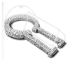
Tholos is a building type with a rectangular planned entrance and a round planned main room. Both round structures and rectangular structures have stone foundations, masonry walls, and plaster [12,16].
ItalyAround 1500 BCLand 14 01463 i002
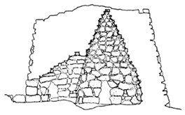
Nuragic culture is noted for monumental architecture and prolific metallurgical activities [17].
ItalyAround 1000 BCLand 14 01463 i003
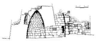
The Etruscan tomb structure showed a significant improvement in the Mediterranean tomb architecture [18].
Spain and PortugalAround 1000 BCLand 14 01463 i004
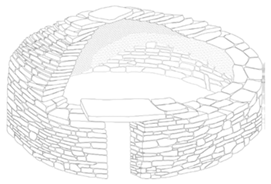
This type of domed structure is used by societies engaged in transhumance activities. According to the seasons, shepherds come to these regions to graze their animals in the summer [19].
Iran (ice houses)Around 440 BCLand 14 01463 i005
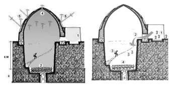
The emergence and development of these structures have occurred through historical processes, the need to keep materials and water cold in the desert heat, and experience and knowledge gained by people [20,21].
Greece6th centuryLand 14 01463 i006These are built in rectangular and terraced forms in a small, modest manner on mountain slopes, low-altitude areas, transition routes, and winter pasture areas [22].
Syria14th centuryLand 14 01463 i007The morphology of the house in towns and villages developed from the material expression of uses, customs, beliefs, and the culture of a particular people [23].
Disclaimer/Publisher’s Note: The statements, opinions and data contained in all publications are solely those of the individual author(s) and contributor(s) and not of MDPI and/or the editor(s). MDPI and/or the editor(s) disclaim responsibility for any injury to people or property resulting from any ideas, methods, instructions or products referred to in the content.

