

Simulating Land Use and Evaluating Spatial Patterns in Wuhan Under Multiple Climate Scenarios: An Integrated SD-PLUS-FD Modeling Approach


Abstract
1. Introduction
2. Methodology and Data Sources
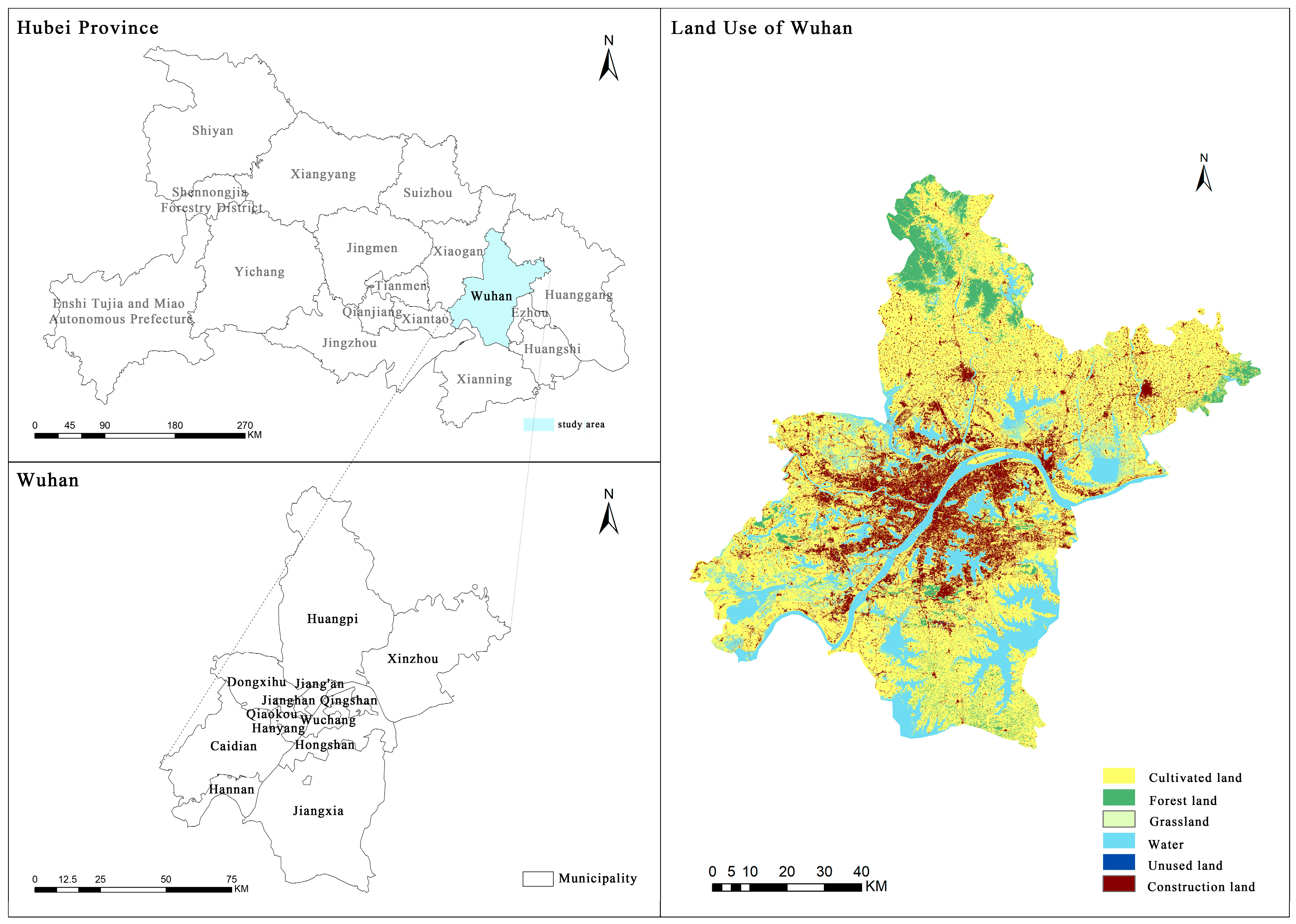
2.1. Study Area Overview
2.2. Data Sources and Processing
2.3. Methodology
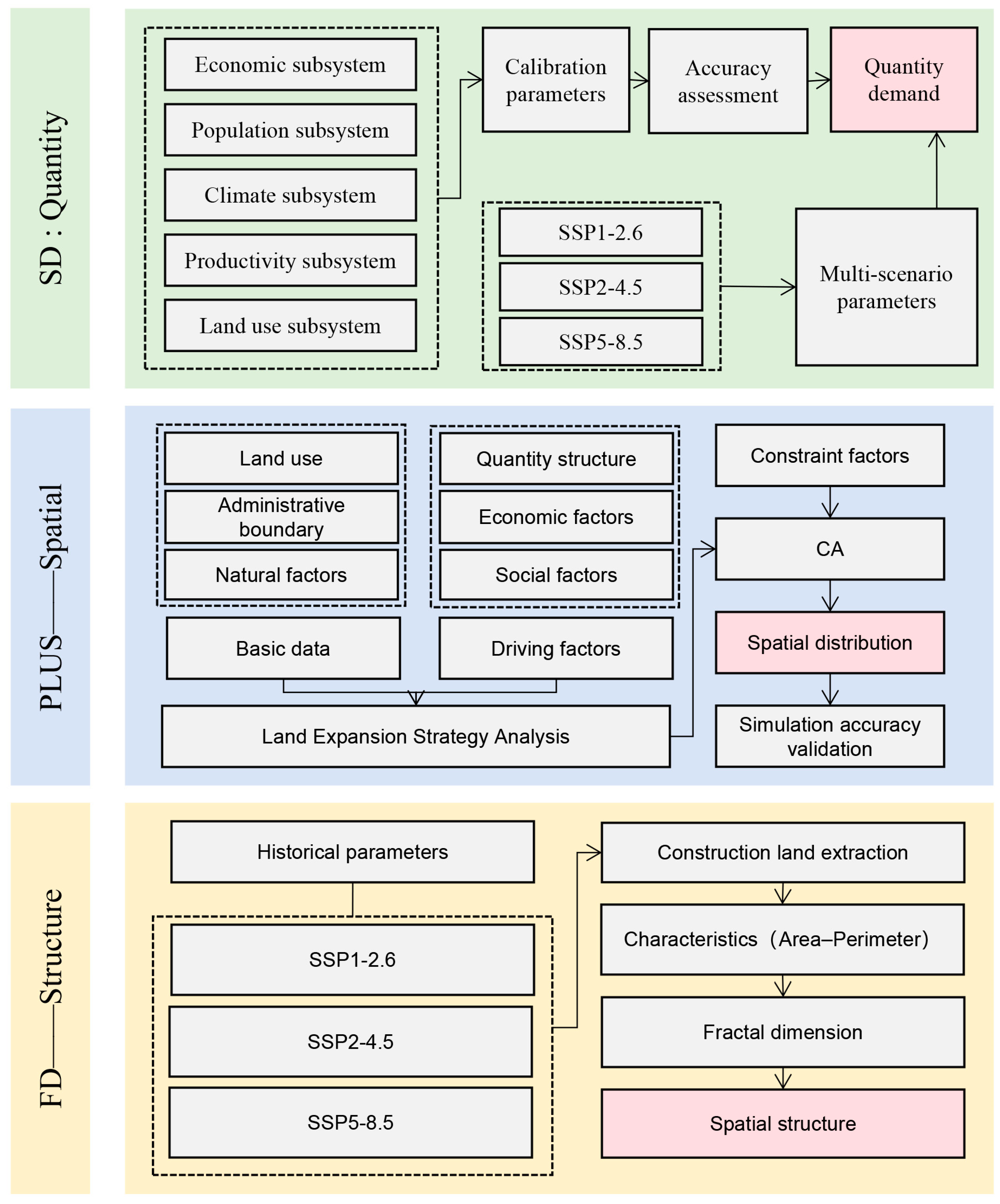
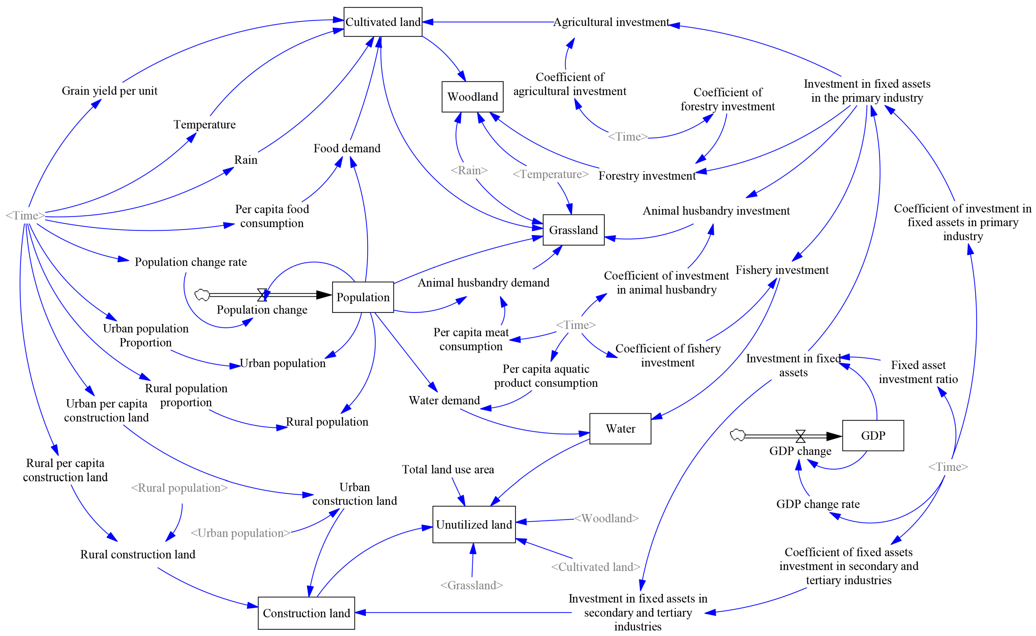
2.3.1. Land Use Demand Forecasting and Validation Based on the SD Model
2.3.2. Multi-Scenario Setting
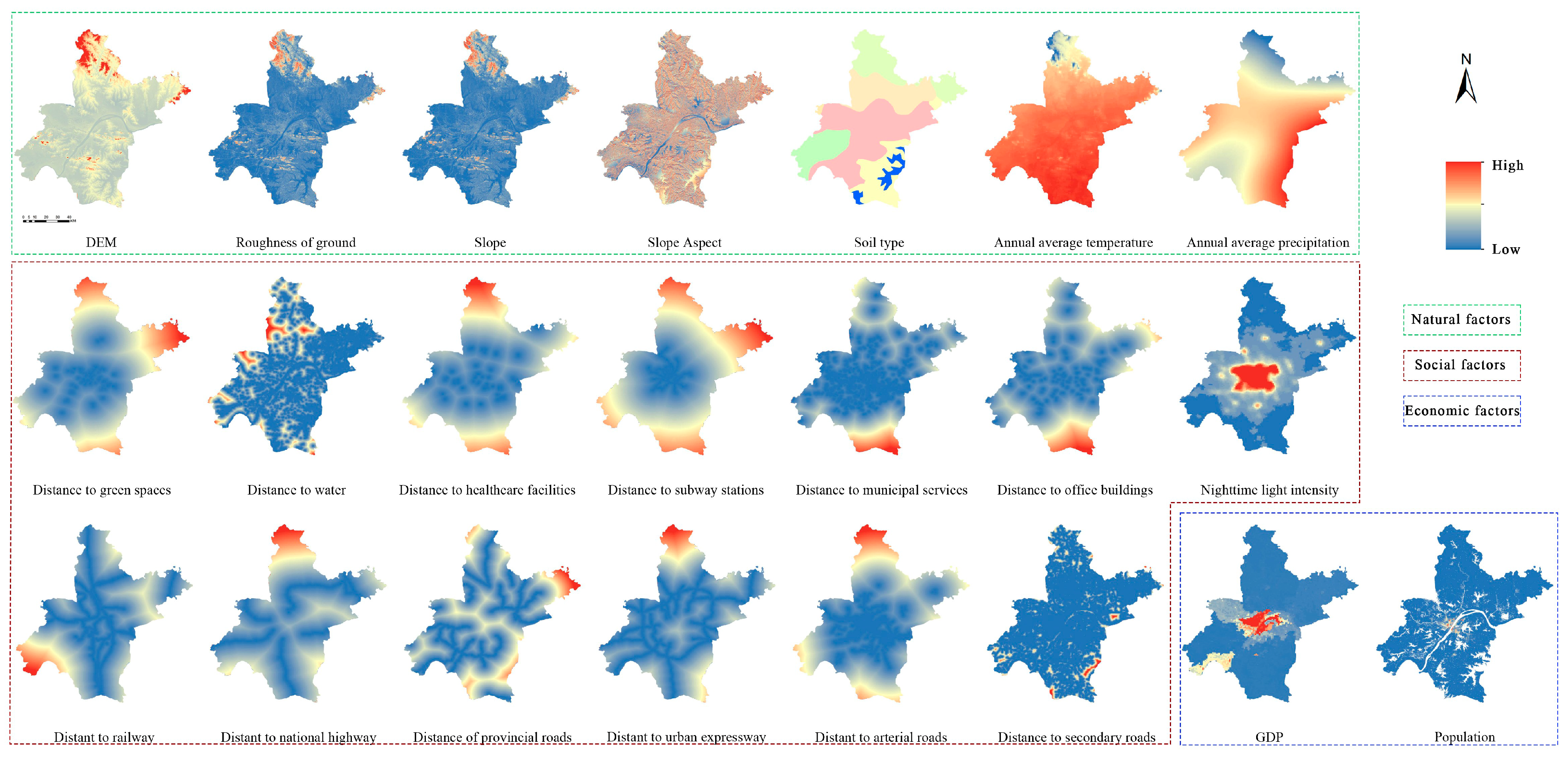
2.3.3. Land Use Simulation and Validation Based on the PLUS Model
2.3.4. Land Use Pattern Evaluation Based on Fractal Dimension
3. Results and Analysis
3.1. Model Accuracy Evaluation
3.1.1. Accuracy Verification of the SD Model
- (1)
- Historical Error Test
- (2)
- Parameter Sensitivity Test
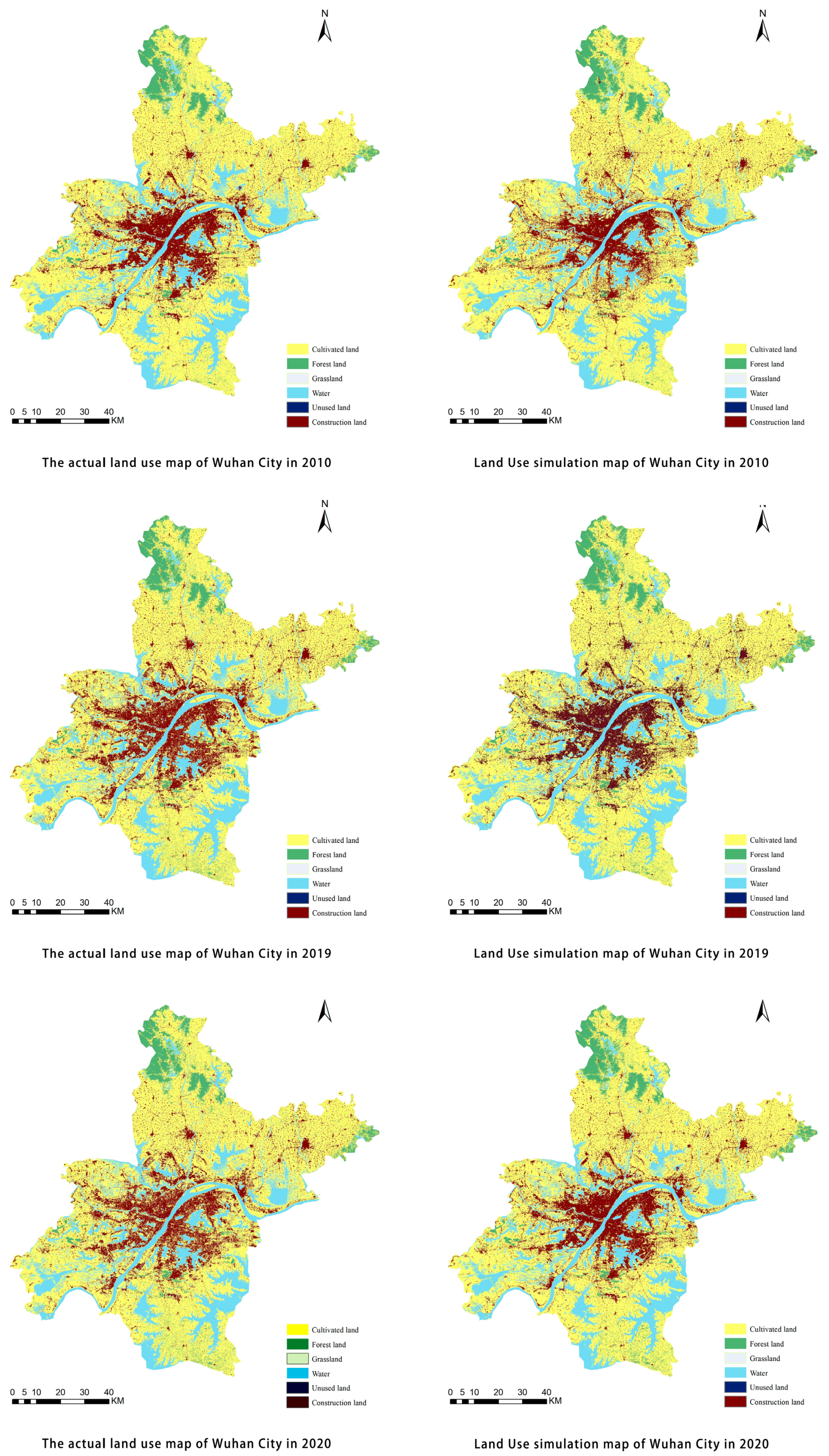
3.1.2. Accuracy Verification of the PLUS Model
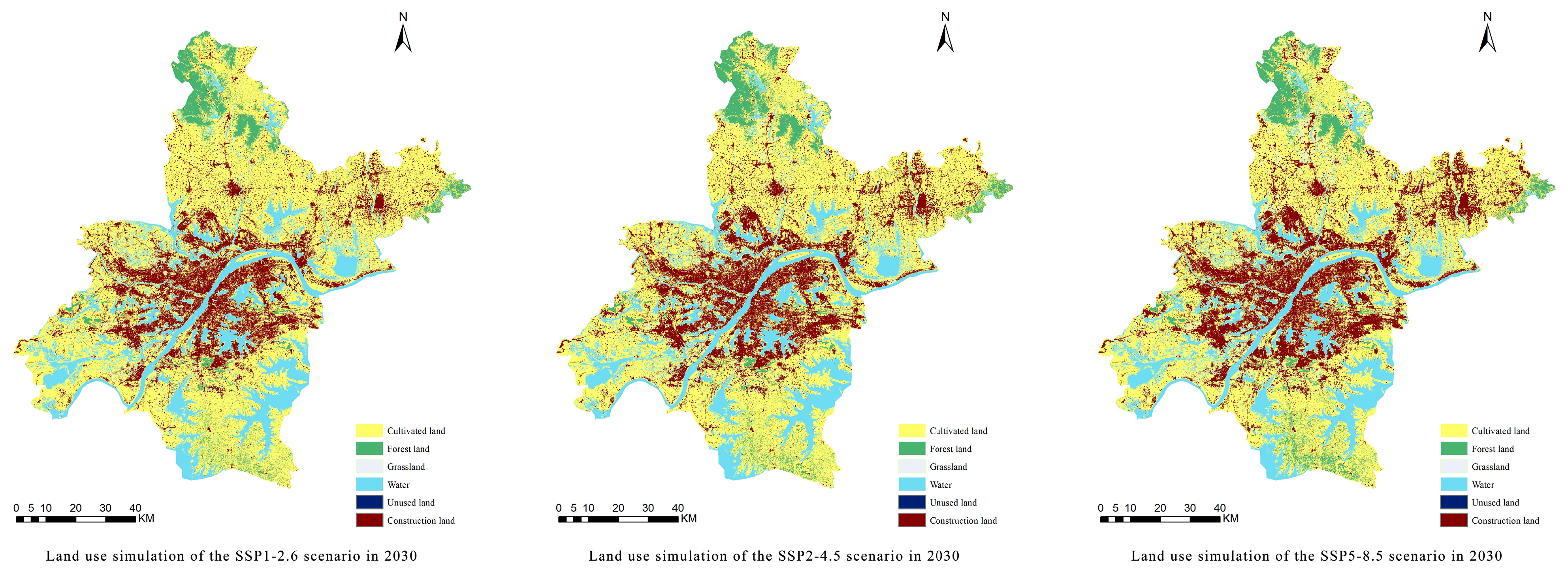
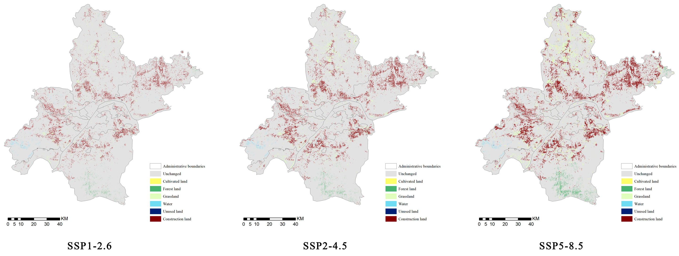
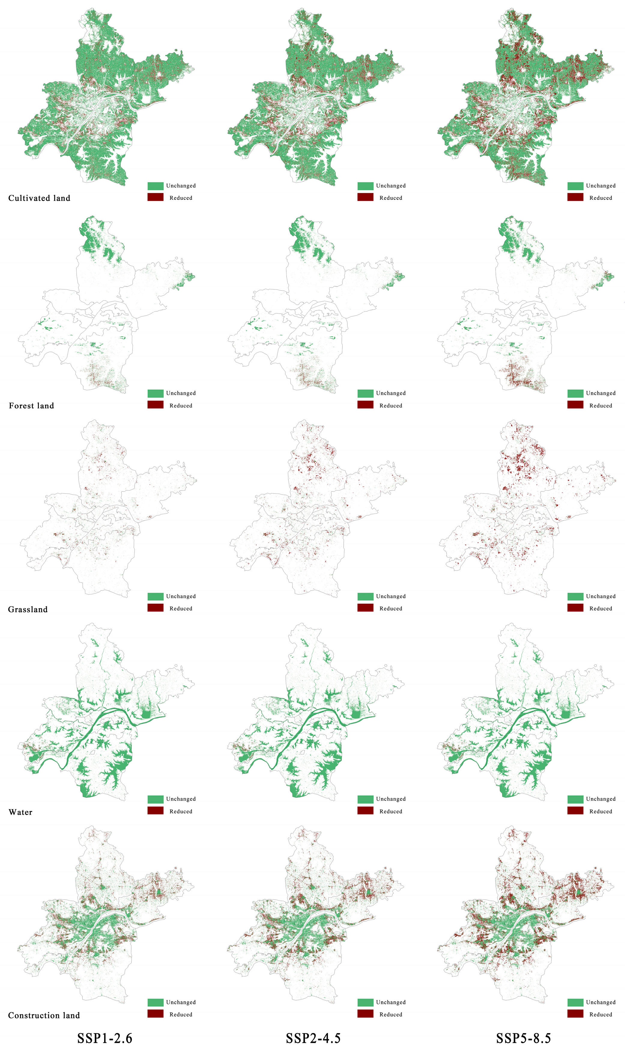
3.2. Analysis of Multi-Scenario Simulation Results
- (1)
- Land Use Demand Forecasting Under Multiple Scenarios
- (2)
- Spatial Pattern Simulation of Land Use Under Multiple Scenarios
- (3)
- Land Use Transition Characteristics Under Multiple Scenarios
3.3. Evaluation of Land Use Pattern Complexity Based on Fractal Dimension
- (1)
- Fractal Dimension Analysis of Different Land Use Types
- (2)
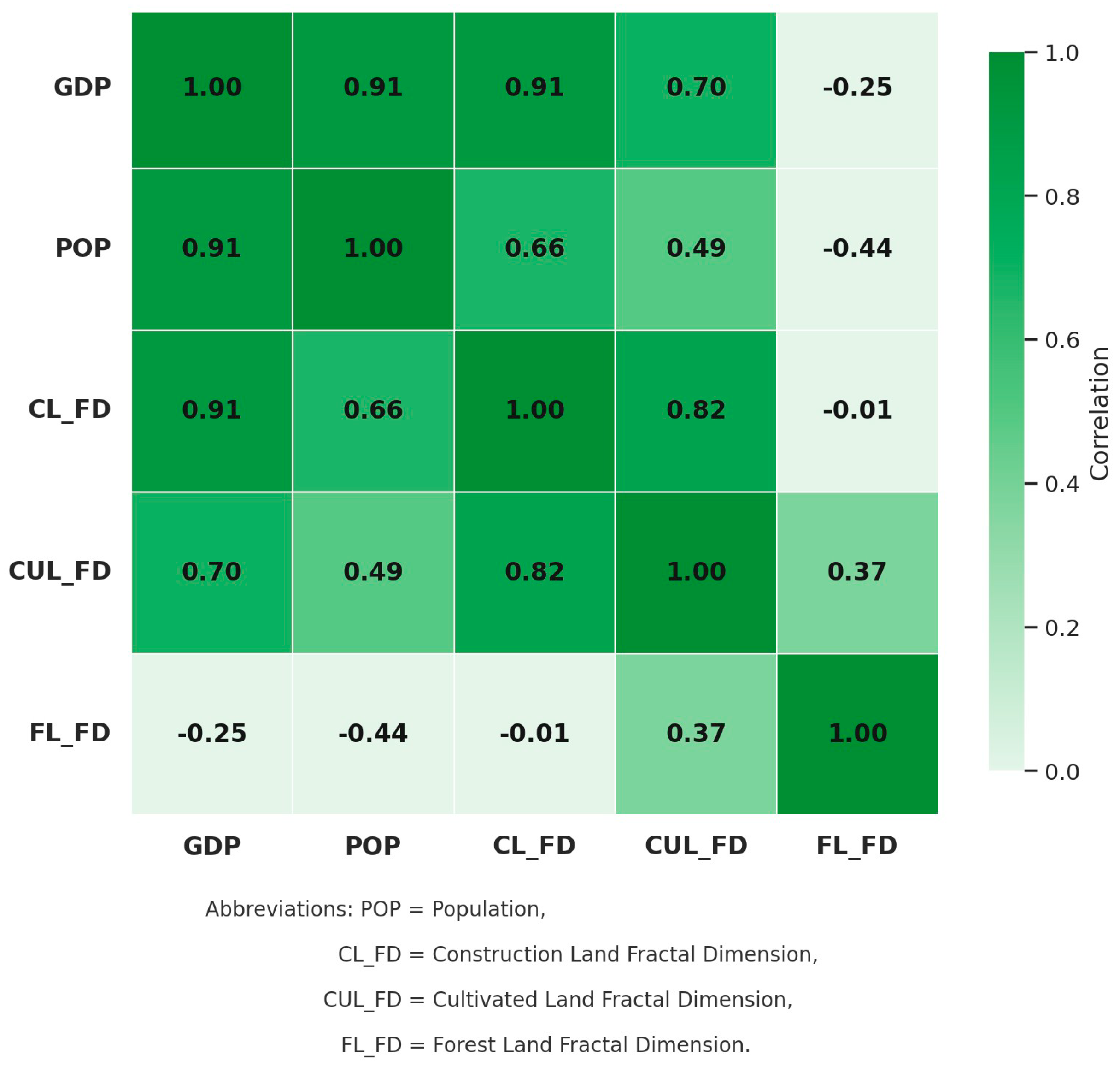
- Coupled Analysis of Fractal Dimension, Population, and GDP
4. Discussion
4.1. Driving Mechanism of Climate Change on Land Use Evolution
4.2. Structural Significance of Land Use Pattern Evaluation
4.3. Disruptive Effects of Sudden Events on Land Use Systems
4.4. Special Interpretation of Fractal Dimension (FD): Fragmentation or Functional Complexity?
4.5. Limitations and Future Outlook
5. Conclusions
- (1)
- The SD-PLUS model demonstrates strong stability, accuracy, and explanatory power across multiple scenarios, effectively supporting the simulation of dynamic responses of urban land systems under different socioclimatic pathways.
- (2)
- Incorporating fractal dimension enables the identification of nonlinear structural patterns in urban boundary evolution, offering a quantitative basis for understanding spatial morphology reconstruction.
- (3)
- Exogenous disturbances, such as public health emergencies, exert significant shocks on land use systems, necessitating the integration of a “resilience–response–adaptation” mechanism in simulation and planning frameworks.
- (4)
- The proposed “quantity–space–structure” integrated framework offers a novel modeling paradigm and practical decision support tool for multi-scenario urban governance and ecological security strategy formulation.
Supplementary Materials
Author Contributions
Funding
Data Availability Statement
Conflicts of Interest
References
- Deng, Y.; Qi, W.; Fu, B.; Wang, K. Geographical Transformations of Urban Sprawl: Exploring the Spatial Heterogeneity across Cities in China 1992–2015. Cities 2020, 105, 102415. [Google Scholar] [CrossRef]
- Chen, H.; Jia, B.; Lau, S.S.Y. Sustainable Urban Form for Chinese Compact Cities: Challenges of a Rapid Urbanized Economy. Habitat Int. 2008, 32, 28–40. [Google Scholar] [CrossRef]
- Jiang, F.; Liu, S.; Yuan, H.; Zhang, Q. Measuring Urban Sprawl in Beijing with Geo-Spatial Indices. J. Geogr. Sci. 2007, 17, 469–478. [Google Scholar] [CrossRef]
- Turner, B.L.; Skole, D.; Sanderson, S.; Fischer, G.; Fresco, L.; Leemans, R. Land-Use and Land-Cover Change: Science/Research Plan. 1995. Available online: https://asu.elsevierpure.com/en/publications/land-use-and-land-cover-change-scienceresearch-plan-2 (accessed on 15 April 2025).
- Wang, S.; Li, Z.; Long, Y.; Yang, L.; Ding, X.; Sun, X.; Chen, T. Impacts of Urbanization on the Spatiotemporal Evolution of Ecological Resilience in the Plateau Lake Area in Central Yunnan, China. Ecol. Indic. 2024, 160, 111836. [Google Scholar] [CrossRef]
- Aghsaei, H.; Mobarghaee Dinan, N.; Moridi, A.; Asadolahi, Z.; Delavar, M.; Fohrer, N.; Wagner, P.D. Effects of Dynamic Land Use/Land Cover Change on Water Resources and Sediment Yield in the Anzali Wetland Catchment, Gilan, Iran. Sci. Total Environ. 2020, 712, 136449. [Google Scholar] [CrossRef]
- Dosdogru, F.; Kalin, L.; Wang, R.; Yen, H. Potential Impacts of Land Use/Cover and Climate Changes on Ecologically Relevant Flows. J. Hydrol. 2020, 584, 124654. [Google Scholar] [CrossRef]
- Guédé, K.G.; Yu, Z.; Simonovic, S.P.; Gu, H.; Emani, G.F.; Badji, O.; Chen, X.; Sika, B.; Adiaffi, B. Combined Effect of Landuse/Landcover and Climate Change Projection on the Spatiotemporal Streamflow Response in Cryosphere Catchment in the Tibetan Plateau. J. Environ. Manag. 2025, 376, 124353. [Google Scholar] [CrossRef]
- Wang, C.; Liu, S.; Zhou, S.; Zhou, J.; Jiang, S.; Zhang, Y.; Feng, T.; Zhang, H.; Zhao, Y.; Lai, Z.; et al. Spatial-Temporal Patterns of Urban Expansion by Land Use/Land Cover Transfer in China. Ecol. Indic. 2023, 155, 111009. [Google Scholar] [CrossRef]
- Shi, K.; Liu, G.; Zhou, L.; Cui, Y.; Liu, S.; Wu, Y. Satellite Remote Sensing Data Reveal Increased Slope Climbing of Urban Land Expansion Worldwide. Landsc. Urban Plan. 2023, 235, 104755. [Google Scholar] [CrossRef]
- Liu, X.; Wang, S.; Wu, P.; Feng, K.; Hubacek, K.; Li, X.; Sun, L. Impacts of Urban Expansion on Terrestrial Carbon Storage in China. Environ. Sci. Technol. 2019, 53, 6834–6844. [Google Scholar] [CrossRef]
- Costanza, R.; Ruth, M. Using Dynamic Modeling to Scope Environmental Problems and Build Consensus. Environ. Manag. 1998, 22, 183–195. [Google Scholar] [CrossRef]
- Li, S.; Liu, X.; Li, X.; Chen, Y. Simulation Model of Land Use Dynamics and Application: Progress and Prospects. Natl. Remote Sens. Bull. 2021, 21, 329–340. [Google Scholar] [CrossRef]
- Song, J.; Tang, B.; Zhang, J.; Dou, X.; Liu, Q.; Shen, W. System Dynamics Simulation for Optimal Stream Flow Regulations under Consideration of Coordinated Development of Ecology and Socio-Economy in the Weihe River Basin, China. Ecol. Eng. 2018, 124, 51–68. [Google Scholar] [CrossRef]
- Gu, C.; Guan, W.; Liu, H. Chinese Urbanization 2050: SD Modeling and Process Simulation. Sci. China Earth Sci. 2017, 60, 1067–1082. [Google Scholar] [CrossRef]
- Jiang, J.; Wang, Z.; Lai, C.; Wu, X.; Chen, X. Climate and Landuse Change Enhance Spatio-Temporal Variability of Dongjiang River Flow and Ammonia Nitrogen. Sci. Total Environ. 2023, 867, 161483. [Google Scholar] [CrossRef]
- Yang, Y.; Wang, W.; Qiao, J.; Zhang, E. An Improved Gray Neural Network Method to Optimize Spatial and Temporal Characteristics Analysis of Land-Use Change. Comput. Intell. Neurosci. 2022, 2022, 2699031. [Google Scholar] [CrossRef]
- Chu, L.; Zhang, X.-R.; Wang, T.-W.; Li, Z.-X.; Cai, C.-F. Spatial-Temporal Evolution and Prediction of Urban Landscape Pattern and Habitat Quality Based on CA-Markov and InVEST Model. Chin. J. Appl. Ecol. 2018, 29, 4106. [Google Scholar] [CrossRef]
- Gasirabo, A.; Xi, C.; Hamad, B.R.; Edovia, U.D. A CA–Markov-Based Simulation and Prediction of LULC Changes over the Nyabarongo River Basin, Rwanda. Land 2023, 12, 1788. [Google Scholar] [CrossRef]
- Xu, C.; Zhang, Q.; Yu, Q.; Wang, J.; Wang, F.; Qiu, S.; Ai, M.; Zhao, J. Effects of Land Use/Cover Change on Carbon Storage between 2000 and 2040 in the Yellow River Basin, China. Ecol. Indic. 2023, 151, 110345. [Google Scholar] [CrossRef]
- Tang, Z.; Ning, R.; Wang, D.; Tian, X.; Bi, X.; Ning, J.; Zhou, Z.; Luo, F. Projections of Land Use/Cover Change and Habitat Quality in the Model Area of Yellow River Delta by Coupling Land Subsidence and Sea Level Rise. Ecol. Indic. 2024, 158, 111394. [Google Scholar] [CrossRef]
- Shi, M.J.; Wu, H.Q.; Jia, H.T.; Zhu, L.; Dong, T.; He, P.X.; Yang, Q.J. Temporal and Spatial Evolution and Prediction of Carbon Stocks in Yili Valley Based on MCE-CA-Markov and InVEST Models. Nongyeziyuan Yu Huanjing Xuebao 2021, 38, 1010–1019. [Google Scholar]
- Zhan, Y.; Zhu, J.; Yan, Y. Dynamic Simulation of Urban Space Based on the Cellular Automata Model. Acta Ecol. Sin. 2017, 37, 4864–4872. [Google Scholar]
- Wu, M.; Ren, X.; Che, Y.; Yang, K. A Coupled SD and CLUE-S Model for Exploring the Impact of Land Use Change on Ecosystem Service Value: A Case Study in Baoshan District, Shanghai, China. Environ. Manag. 2015, 56, 402–419. [Google Scholar] [CrossRef]
- Wang, Q.; Liu, R.; Men, C.; Guo, L. Application of Genetic Algorithm to Land Use Optimization for Non-Point Source Pollution Control Based on CLUE-S and SWAT. J. Hydrol. 2018, 560, 86–96. [Google Scholar] [CrossRef]
- Peng, J.; Wei, H.; Wu, W.; Liu, Y.; Wang, Y. Storm Flood Disaster Risk Assessment in Urban Area Based on the Simulation of Land Use Scenarios: A Case of Maozhou Watershed in Shenzhen City. Acta Ecol. Sin. 2018, 38, 3741–3755. [Google Scholar] [CrossRef]
- Yu, Q.; Wu, Z.; Wang, Y. A Land Use Change Simulation Model: Coupling of Evolutionary Algorithm and FLUS Model. J. Geo-Inf. Sci. 2023, 25, 510–528. [Google Scholar] [CrossRef]
- Ding, Q.; Chen, Y.; Bu, L.; Ye, Y. Multi-Scenario Analysis of Habitat Quality in the Yellow River Delta by Coupling FLUS with InVEST Model. Int. J. Environ. Res. Public Health 2021, 18, 2389. [Google Scholar] [CrossRef]
- Lin, W.; Sun, Y.; Nijhuis, S.; Wang, Z. Scenario-Based Flood Risk Assessment for Urbanizing Deltas Using Future Land-Use Simulation (FLUS): Guangzhou Metropolitan Area as a Case Study. Sci. Total Environ. 2020, 739, 139899. [Google Scholar] [CrossRef]
- Liu, J.; Xiong, J.; Chen, Y.; Sun, H.; Zhao, X.; Tu, F.; Gu, Y. An Integrated Model Chain for Future Flood Risk Prediction under Land-Use Changes. J. Environ. Manag. 2023, 342, 118125. [Google Scholar] [CrossRef]
- Guo, W.; Teng, Y.; Li, J.; Yan, Y.; Zhao, C.; Li, Y.; Li, X. A New Assessment Framework to Forecast Land Use and Carbon Storage under Different SSP-RCP Scenarios in China. Sci. Total Environ. 2024, 912, 169088. [Google Scholar] [CrossRef]
- Cai, G.; Xiong, J.; Wen, L.; Weng, A.; Lin, Y.; Li, B. Predicting the Ecosystem Service Values and Constructing Ecological Security Patterns in Future Changing Land Use Patterns. Ecol. Indic. 2023, 154, 110787. [Google Scholar] [CrossRef]
- Wang, C.; Li, T.; Guo, X.; Xia, L.; Lu, C.; Wang, C. Plus-InVEST Study of the Chengdu-Chongqing Urban Agglomeration’s Land-Use Change and Carbon Storage. Land 2022, 11, 1617. [Google Scholar] [CrossRef]
- Lin, B.; Chen, X.; Yao, H.; Chen, Y.; Liu, M.; Gao, L.; James, A. Analyses of Landuse Change Impacts on Catchment Runoff Using Different Time Indicators Based on SWAT Model. Ecol. Indic. 2015, 58, 55–63. [Google Scholar] [CrossRef]
- Memarian, H.; Balasundram, S.K.; Abbaspour, K.C.; Talib, J.B.; Sung, C.T.B.; Sood, A.M. SWAT-Based Hydrological Modelling of Tropical Land-Use Scenarios. Hydrol. Sci. J. 2014, 59, 1808–1829. [Google Scholar] [CrossRef]
- Sun, J.; Yan, H.; Bao, Z.; Wang, G. Investigating Impacts of Climate Change on Runoff from the Qinhuai River by Using the SWAT Model and CMIP6 Scenarios. Water 2022, 14, 1778. [Google Scholar] [CrossRef]
- Duguma, D.W.; Brueck, M.; Shumi, G.; Law, E.; Benra, F.; Schultner, J.; Nemomissa, S.; Abson, D.J.; Fischer, J. Future Ecosystem Service Provision under Land-Use Change Scenarios in Southwestern Ethiopia. Ecosyst. People 2024, 20, 2321613. [Google Scholar] [CrossRef]
- Hua, Y.; Yan, D.; Liu, X. Assessing Synergies and Trade-Offs between Ecosystem Services in Highly Urbanized Area under Different Scenarios of Future Land Use Change. Environ. Sustain. Indic. 2024, 22, 100350. [Google Scholar] [CrossRef]
- Redhead, J.W.; May, L.; Oliver, T.H.; Hamel, P.; Sharp, R.; Bullock, J.M. National Scale Evaluation of the InVEST Nutrient Retention Model in the United Kingdom. Sci. Total Environ. 2018, 610–611, 666–677. [Google Scholar] [CrossRef]
- Yin, L.; Li, X.; Zheng, W.; Yin, Z.; Song, L.; Ge, L.; Zeng, Q. Fractal Dimension Analysis for Seismicity Spatial and Temporal Distribution in the Circum-Pacific Seismic Belt. J. Earth Syst. Sci. 2019, 128, 22. [Google Scholar] [CrossRef]
- Muolo, A.; Konaxis, I.; Salvati, L. Applying Zipf’s Law to Land-Use Classes in a Tourism-Specialized Metropolitan Context. Land Use Policy 2025, 155, 107580. [Google Scholar] [CrossRef]
- Zhou, Y.; Li, Y. Scaling the Living Space: Zipf’s Law for Traditional Courtyard Houses in South China. Front. Built Environ. 2022, 8, 901776. [Google Scholar] [CrossRef]
- Postigliola, M.; Salvati, L. Land-Use Change and Zipf’s Law: A Novel Tool to Investigate Regional Transformations. Pap. Reg. Sci. 2025, 104, 100074. [Google Scholar] [CrossRef]
- Batty, M.; Longley, P. Fractal Cities: A Geometry of Form and Function; Academic Press: Cambridge, MA, USA, 1994; ISBN 978-0-12-455570-9. [Google Scholar]
- Benguigui, L.; Marinov, M.; Czamanski, D.; Portugali, Y. When and Where Is a City Fractal? Environ. Plan. B Plan. Des. 1999, 27, 507–519. [Google Scholar] [CrossRef]
- Marques, M.L. Metodologias para Estimativa da Dimensão Fractal do Crescimento de Aglomerados Urbanos: Uma Contribuição ao Estudo da Expansão Urbana da Região Metropolitana de São Paulo Entre 1905 e 2001. Ph.D. Thesis, UNESP, São Paulo, Brazil, 2005. [Google Scholar]
- Xu, X.; Min, X. Quantifying Spatiotemporal Patterns of Urban Expansion in China Using Remote Sensing Data. Cities 2013, 35, 104–113. [Google Scholar] [CrossRef]
- Agostinho, F.; Costa, M.; Coscieme, L.; Almeida, C.M.V.B.; Giannetti, B.F. Assessing Cities Growth-Degrowth Pulsing by Emergy and Fractals: A Methodological Proposal. Cities 2021, 113, 103162. [Google Scholar] [CrossRef]
- Winz, I.; Brierley, G.; Trowsdale, S. The Use of System Dynamics Simulation in Water Resources Management. Water Resour. Manag. 2009, 23, 1301–1323. [Google Scholar] [CrossRef]
- Li, F.; Liu, D.; Kong, X.; Liu, Y. Multi-Scenario Evaluation of County-Scale Development Potential Based on Shared Socioeconomic Pathways and Dynamic Simulation Approach. J. Geo-Inf. Sci. 2022, 24, 684–697. [Google Scholar] [CrossRef]
- Gu, M.; Ye, C.; Li, X.; Hu, M. Scenario Simulation of Land Use Change in Jiangxi Province Based on SD Model. Geogr. Geo-Inf. Sci. 2022, 38, 95–103. [Google Scholar]
- Gu, H.; Ma, T.; Qian, F.; Cai, Y. County land use scenario simulation and carbon emission effect analysis using CLUE-S model. Trans. Chin. Soc. Agric. Eng. 2022, 38, 288–296. [Google Scholar] [CrossRef]
- Abadi, L.S.K.; Shamsai, A.; Goharnejad, H. An Analysis of the Sustainability of Basin Water Resources Using Vensim Model. KSCE J. Civ. Eng. 2015, 19, 1941–1949. [Google Scholar] [CrossRef]
- Qu, L.; Tu, Z.; Liu, J.; Li, Y. Coupling Coordination Evolution of the Settlements-Farming System and Its Optimization Path: Keys to Sustainable Rural Development in the Three Gorges Reservoir Area of China. Habitat Int. 2025, 163, 103456. [Google Scholar] [CrossRef]
- Yeh, S.-C.; Wang, C.-A.; Yu, H.-C. Simulation of Soil Erosion and Nutrient Impact Using an Integrated System Dynamics Model in a Watershed in Taiwan. Environ. Model. Softw. 2006, 21, 937–948. [Google Scholar] [CrossRef]
- Van Vuuren, D.P.; Carter, T.R. Climate and Socio-Economic Scenarios for Climate Change Research and Assessment: Reconciling the New with the Old. Clim. Chang. 2014, 122, 415–429. [Google Scholar] [CrossRef]
- Li, J.; Chen, X.; Kurban, A.; Voorde, T.; Maeyer, P.; Zhang, C. Coupled SSPs-RCPs Scenarios to Project the Future Dynamic Variations of Water-Soil-Carbon-Biodiversity Services in Central Asia. Ecol. Indic. 2021, 129, 107936. [Google Scholar] [CrossRef]
- Liang, X.; Guan, Q.; Clarke, K.C.; Liu, S.; Wang, B.; Yao, Y. Understanding the Drivers of Sustainable Land Expansion Using a Patch-Generating Land Use Simulation (PLUS) Model: A Case Study in Wuhan, China. Comput. Environ. Urban Syst. 2020, 85, 101569. [Google Scholar] [CrossRef]
- Yang, Y.; Bao, W.; Liu, Y. Scenario Simulation of Land System Change in the Beijing-Tianjin-Hebei Region. Land Use Policy 2020, 96, 104677. [Google Scholar] [CrossRef]
- Xie, X.D.; Lin, X.S.; Wang, Y.; Tu, R.Y.; Zhang, J.X. Multi-Scenario Simulation of Land Use in Nanchuan District of Chongqing Based on PLUS Model. J. Chang. River Sci. Res. Inst. 2023, 40, 86. [Google Scholar] [CrossRef]
- Hu, Y.; Li, T. Forecasting Spatial Pattern of Land Use Change in Rapidly Urbanized Regions Based on SD-CA Model. Acta Sci. Nat. Univ. Pekin. 2022, 58, 372. [Google Scholar] [CrossRef]
- Liang, X.; Liu, X.; Li, X.; Chen, Y.; Tian, H.; Yao, Y. Delineating Multi-Scenario Urban Growth Boundaries with a CA-Based FLUS Model and Morphological Method. Landsc. Urban Plan. 2018, 177, 47–63. [Google Scholar] [CrossRef]
- Wu, X.; Huang, X.; Guo, S. The Fractal Characteristics and Risk Indicators of Urban Ecological Environment Vulnerability Evolution. Ecol. Inform. 2025, 86, 103033. [Google Scholar] [CrossRef]
- Mandelbrot, B. How Long Is the Coast of Britain? Statistical Self-Similarity and Fractional Dimension. Science 1967, 156, 636–638. [Google Scholar] [CrossRef]
- Turcotte, D.L. Fractals and Chaos in Geology and Geophysics, 2nd ed.; Cambridge University Press: Cambridge, UK, 1997; ISBN 978-0-521-56733-6. [Google Scholar]
- Turcotte, D.L. Fractal River Basins–Chance and Self-Organization. Eos Trans. Am. Geophys. Union 1998, 79, 463. [Google Scholar] [CrossRef]
- Cheng, Q.; Agterberg, F.P.; Ballantyne, S.B. The Separation of Geochemical Anomalies from Background by Fractal Methods. J. Geochem. Explor. 1994, 51, 109–130. [Google Scholar] [CrossRef]
- Chen, Y.; Feng, J. Spatial Analysis of Cities Using Renyi Entropy and Fractal Parameters. Chaos Solitons Fractals 2017, 105, 279–287. [Google Scholar] [CrossRef]
- Bharathi, N.; Malghan, D.; Mishra, S.; Rahman, A. Fractal Urbanism: City Size and Residential Segregation in India. World Dev. 2021, 141, 105397. [Google Scholar] [CrossRef]
- Guo, S.; Pei, T.; Xie, S.; Song, C.; Jie, C.; Liu, Y.; Shu, H.; Wang, X.; Yin, L. Fractal Dimension of Job-Housing Flows: A Comparison between Beijing and Shenzhen. Cities 2021, 112, 103120. [Google Scholar] [CrossRef]
- Moriasi, D.; Arnold, J.; Van Liew, M.; Bingner, R.; Harmel, R.D.; Veith, T. Model Evaluation Guidelines for Systematic Quantification of Accuracy in Watershed Simulations. Trans. ASABE 2007, 50, 885–900. [Google Scholar] [CrossRef]
- Arora, A.; Pandey, M.; Mishra, V.; Rai, P.; Costache, R.-D.; Punia, M.; Di, L. Comparative Evaluation of Geospatial Scenario-Based Land Change Simulation Models Using Landscape Metrics. Ecol. Indic. 2021, 128, 107810. [Google Scholar] [CrossRef]


| Model Type | Model | Advantages | Disadvantages |
|---|---|---|---|
| Quantity Prediction Models | SD | Capable of simulating nonlinear dynamic feedback mechanisms; Able to integrate socioeconomic variables; Suitable for policy scenario analysis | Strong subjectivity in parameter setting; Weak capability in representing spatial distribution; Limited ability to capture microlevel heterogeneity |
| MC | Simple and easy to use; Intuitive in modeling land transition probabilities | Ignores spatial relationships; Incapable of handling complex driving mechanisms; Only simulates static transitions without dynamic feedback | |
| GM | Suitable for small-sample datasets; Simple modeling process | Relies on idealized assumptions; Lacks spatial modeling capability; Accuracy is highly sensitive to data fluctuations | |
| Spatial Distribution Models | CA | Simple structure; Clear rules; Suitable for simulating spatial neighborhood changes | Strong subjectivity in rule setting; Lacks system-level feedback mechanisms; Unstable in long-term evolution simulations |
| CLUE-S | Considers multiple driving factors; Flexible in land use type transitions | Complex parameter tuning; Lacks temporal feedback mechanisms; Difficult to handle structural evolution analysis | |
| FLUS | Introduces stochastic disturbance mechanisms; Optimizes the CA seeding mechanism; Better adapted to complex land use categories | Relatively complex model logic; High sensitivity to driving factors; Also lacks the ability for structural analysis | |
| PLUS | Based on the LEAS strategy and multi-type patch seeding mechanism; High spatial allocation accuracy; Easily integrated with other models | Spatially dominated; quantity prediction relies on external models; Still limited in expressing structural complexity |
| Category | Name of Data | Data Source | |
|---|---|---|---|
| Nonspatial data | Population (2000–2020), economy (2000–2020) | Statistical Yearbook of Wuhan City | |
| Demand for grain, animal husbandry, and water resources | National Bureau of Statistics (https://www.stats.gov.cn/) | ||
| Spatial data | Basic data | Land use data (2000–2020) | Globeland 30 (https://aircas.cas.cn/) |
| Natural driving factor | DEM, slope, aspect, average annual temperature, average annual rainfall, soil type, distance to water bodies, etc. | Geospatial Data Cloud (http://www.gscloud.cn/), The Data Center for Resources and Environmental Sciences (https://www.resdc.cn/) | |
| Economic driving factor | Population density, GDP, distance to government locations, distance to medical and health facilities, etc. | The Data Center for Resources and Environmental Sciences (https://www.resdc.cn/) | |
| Social driving factor | Distance to expressways, distance to national highways, distance to provincial highways, distance to subways, distance to railways, etc. | Open Street Map (https://www.openstreetmap.org/) | |
| Limiting factor | Water area | Relevant planning documents | |
| Scenarios | Population Growth Rate | GDP Growth Rate | Annual Average Temperature Variation °C·a − 1 | Annual Average Precipitation Variation mm·a − 1 |
|---|---|---|---|---|
| SSP1-2.6 | 2.02% | Linear decrease to 5% | 0.01 | 2.6 |
| SSP2-4.5 | 4.12% | Average 7% | 0.025 | 4.3 |
| SSP5-8.5 | 6% | Linear rise to 10% | 0.055 | 7.5 |
| Cultivated Land | Forest Land | Grassland | Water Body | Construction Land | |
|---|---|---|---|---|---|
| Historical values 2010 | 5382.60 | 452.47 | 52.79 | 1530.11 | 1151.18 |
| Simulated value | 5411.87 | 454.74 | 52.32 | 1530.78 | 1139.77 |
| Relative error | 0.54% | 0.50% | −0.88% | 0.04% | −0.99% |
| Historical values 2011 | 5359.33 | 451.55 | 55.68 | 1526.44 | 1176.16 |
| Simulated value | 5359.51 | 452.57 | 63.54 | 1530.70 | 1166.60 |
| Relative error | 0.00% | 0.23% | 14.12% | 0.28% | −0.81% |
| Historical values 2019 | 5120.45 | 496.89 | 98.02 | 1527.69 | 1326.11 |
| Simulated value | 5145.13 | 493.64 | 92.72 | 1532.06 | 1334.95 |
| Relative error | 0.48% | −0.65% | −5.41% | 0.29% | 0.67% |
| Historical values 2020 | 5283.42 | 421.65 | 96.24 | 1530.22 | 1237.62 |
| Simulated value | 5254.01 | 509.97 | 99.18 | 1547.28 | 1368.94 |
| Relative error | −0.56% | 20.95% | 3.06% | 1.11% | 10.61% |
| Parameter | Parameters Reduce Sensitivity by 10% | Parameter Increases Sensitivity by 10% |
|---|---|---|
| Population growth rate | 0.0221 | 0.1166 |
| GDP growth rate | 0.1065 | 0.2333 |
| Fixed asset investment coefficient | 0.0635 | 0.1056 |
| Investment coefficient of the primary industry | 0.0380 | 0.0698 |
| Investment coefficient of the secondary and tertiary industries | 0.0267 | 0.0266 |
| Agricultural investment coefficient | 0.0286 | 0.0447 |
| Forestry investment coefficient | 0.0113 | 0.0277 |
| Investment coefficient of animal husbandry | 0.0045 | 0.0846 |
| Fishery investment coefficient | - | - |
| Construction Land | Cultivated Land | Grassland | Forest Land | Water Bodies | Unused Land | |
|---|---|---|---|---|---|---|
| SSP1-2.6 | 1554.27 | 4784.46 | 172.52 | 527.22 | 1530.68 | - |
| SSP2-4.5 | 1688.38 | 4572.83 | 241.79 | 535.47 | 1530.68 | - |
| SSP5-8.5 | 1890.45 | 4260.73 | 331.47 | 555.82 | 1530.68 | - |
| SSP1-2.6 Scenario | SSP2-4.5 Scenario | SSP5-8.5 Scenario | ||||||||||||||||
|---|---|---|---|---|---|---|---|---|---|---|---|---|---|---|---|---|---|---|
| a | b | c | d | e | f | a | b | c | d | e | f | a | b | c | d | e | f | |
| a | 1 | 1 | 1 | 1 | 1 | 1 | 1 | 1 | 1 | 1 | 1 | 1 | 1 | 1 | 1 | 1 | 1 | 1 |
| b | 0 | 1 | 0 | 0 | 0 | 0 | 0 | 1 | 1 | 1 | 1 | 1 | 1 | 1 | 1 | 1 | 1 | 1 |
| c | 0 | 1 | 1 | 0 | 0 | 0 | 0 | 1 | 1 | 1 | 1 | 1 | 1 | 1 | 1 | 1 | 1 | 1 |
| d | 0 | 0 | 0 | 1 | 0 | 0 | 0 | 0 | 0 | 1 | 0 | 0 | 0 | 0 | 0 | 1 | 0 | 0 |
| e | 0 | 0 | 0 | 0 | 1 | 0 | 0 | 0 | 0 | 0 | 1 | 0 | 0 | 0 | 0 | 0 | 1 | 0 |
| f | 1 | 1 | 1 | 1 | 1 | 1 | 1 | 1 | 1 | 1 | 1 | 1 | 1 | 1 | 1 | 1 | 1 | 1 |
| Dimension | Positive Interspersion | Negative Fragmentation |
|---|---|---|
| Patch Distribution | Ordered intermixing of construction and green spaces | Scattered urban patches, passively segmented |
| Spatial Continuity | Functional coherence, ecological corridors maintained | Disconnected structure, chaotic boundaries |
| Formation Mechanism | Multi-centric planning, ecological zoning | Uncontrolled sprawl, lack of governance |
| Ecological Embedding | Urban land embedded within ecological networks | Green spaces isolated, “island” effect intensified |
| Structural Attribute | High FD = fine-grained, multi-functional (positive) | High FD = disordered, low organization (negative) |
Disclaimer/Publisher’s Note: The statements, opinions and data contained in all publications are solely those of the individual author(s) and contributor(s) and not of MDPI and/or the editor(s). MDPI and/or the editor(s) disclaim responsibility for any injury to people or property resulting from any ideas, methods, instructions or products referred to in the content. |
© 2025 by the authors. Licensee MDPI, Basel, Switzerland. This article is an open access article distributed under the terms and conditions of the Creative Commons Attribution (CC BY) license (https://creativecommons.org/licenses/by/4.0/).
Share and Cite
Yuan, H.; Li, X.; Ding, M.; Shen, G.; Xu, M. Simulating Land Use and Evaluating Spatial Patterns in Wuhan Under Multiple Climate Scenarios: An Integrated SD-PLUS-FD Modeling Approach. Land 2025, 14, 1412. https://doi.org/10.3390/land14071412
Yuan H, Li X, Ding M, Shen G, Xu M. Simulating Land Use and Evaluating Spatial Patterns in Wuhan Under Multiple Climate Scenarios: An Integrated SD-PLUS-FD Modeling Approach. Land. 2025; 14(7):1412. https://doi.org/10.3390/land14071412
Chicago/Turabian StyleYuan, Hao, Xinyu Li, Meichen Ding, Guoqiang Shen, and Mengyuan Xu. 2025. "Simulating Land Use and Evaluating Spatial Patterns in Wuhan Under Multiple Climate Scenarios: An Integrated SD-PLUS-FD Modeling Approach" Land 14, no. 7: 1412. https://doi.org/10.3390/land14071412
APA StyleYuan, H., Li, X., Ding, M., Shen, G., & Xu, M. (2025). Simulating Land Use and Evaluating Spatial Patterns in Wuhan Under Multiple Climate Scenarios: An Integrated SD-PLUS-FD Modeling Approach. Land, 14(7), 1412. https://doi.org/10.3390/land14071412