
SDI-Enabled Smart Governance: A Review (2015–2025) of IoT, AI and Geospatial Technologies—Applications and Challenges


Abstract
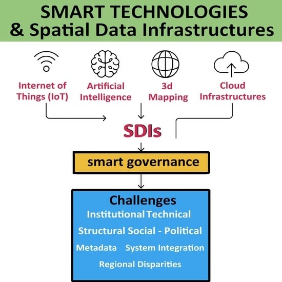
1. Introduction
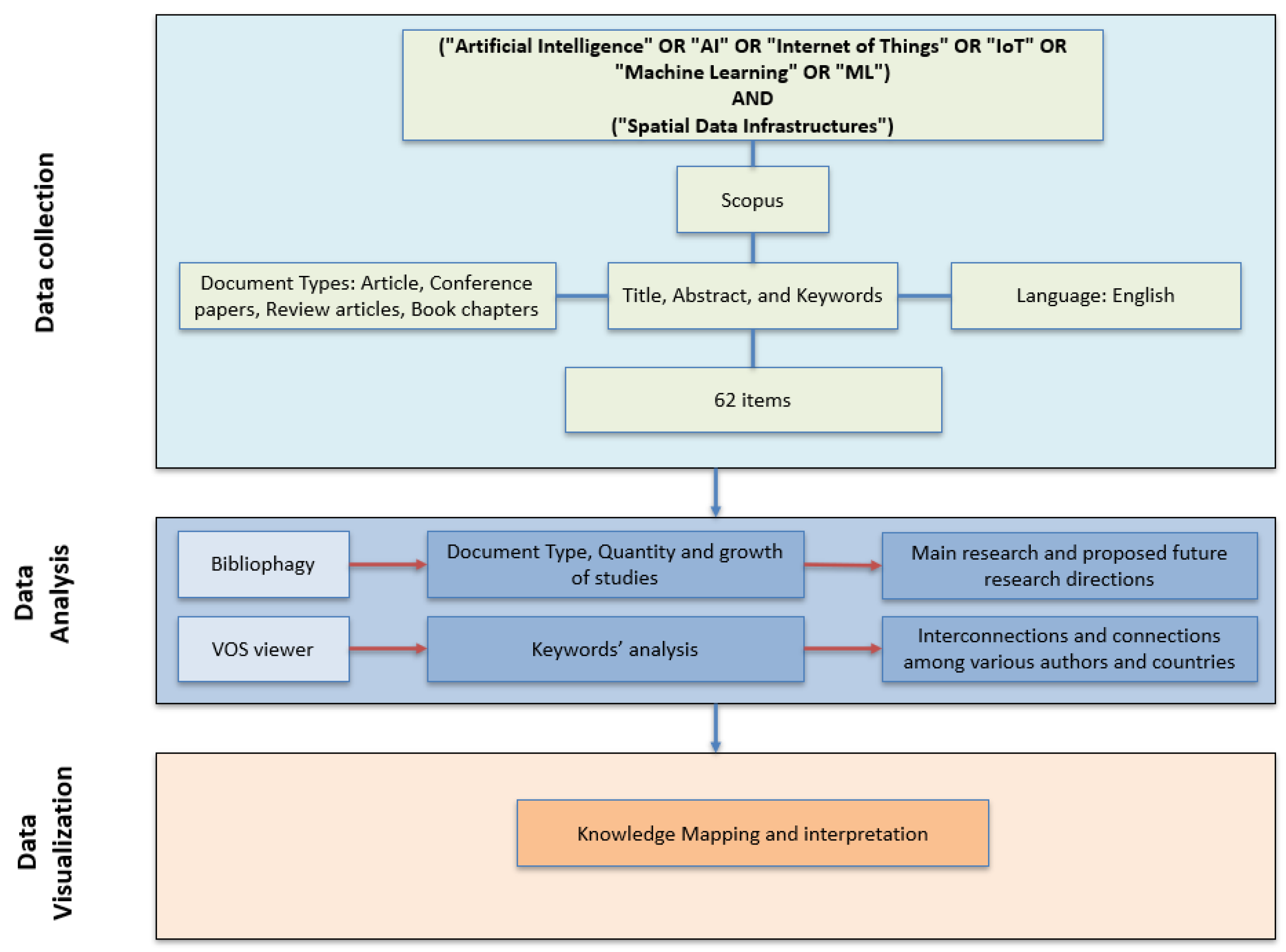
2. Materials and Methods
2.1. Search and Selection Criteria
- IC1: Language – Only publications written in English were included to ensure accessibility to internationally recognized scientific literature.
- IC2: Timeframe – The analysis covered the period from 2015 to 2025 in order to capture the most recent technological advancements and trends, as well as the evolutionary arc of SDI integration with emerging digital technologies.
- IC3: Content Focus and Thematic Scope—Studies were considered eligible only if they explicitly addressed the relationship between Spatial Data Infrastructures (SDIs) and smart city technologies such as Artificial Intelligence (AI), Machine Learning (ML), or the Internet of Things (IoT). Eligible studies included theoretical models, methodological frameworks, case studies, and practical implementations. Publications that focused solely on these technologies without any reference to SDIs were excluded.
- IC4: Geospatial Interoperability Standards – Although not a strict inclusion requirement, references to interoperability standards (e.g., OGC, INSPIRE, ISO 19100 [32]) were considered valuable for enriching the analysis of interoperability aspects.
2.2. Study Selection
2.3. Descriptive Statistics
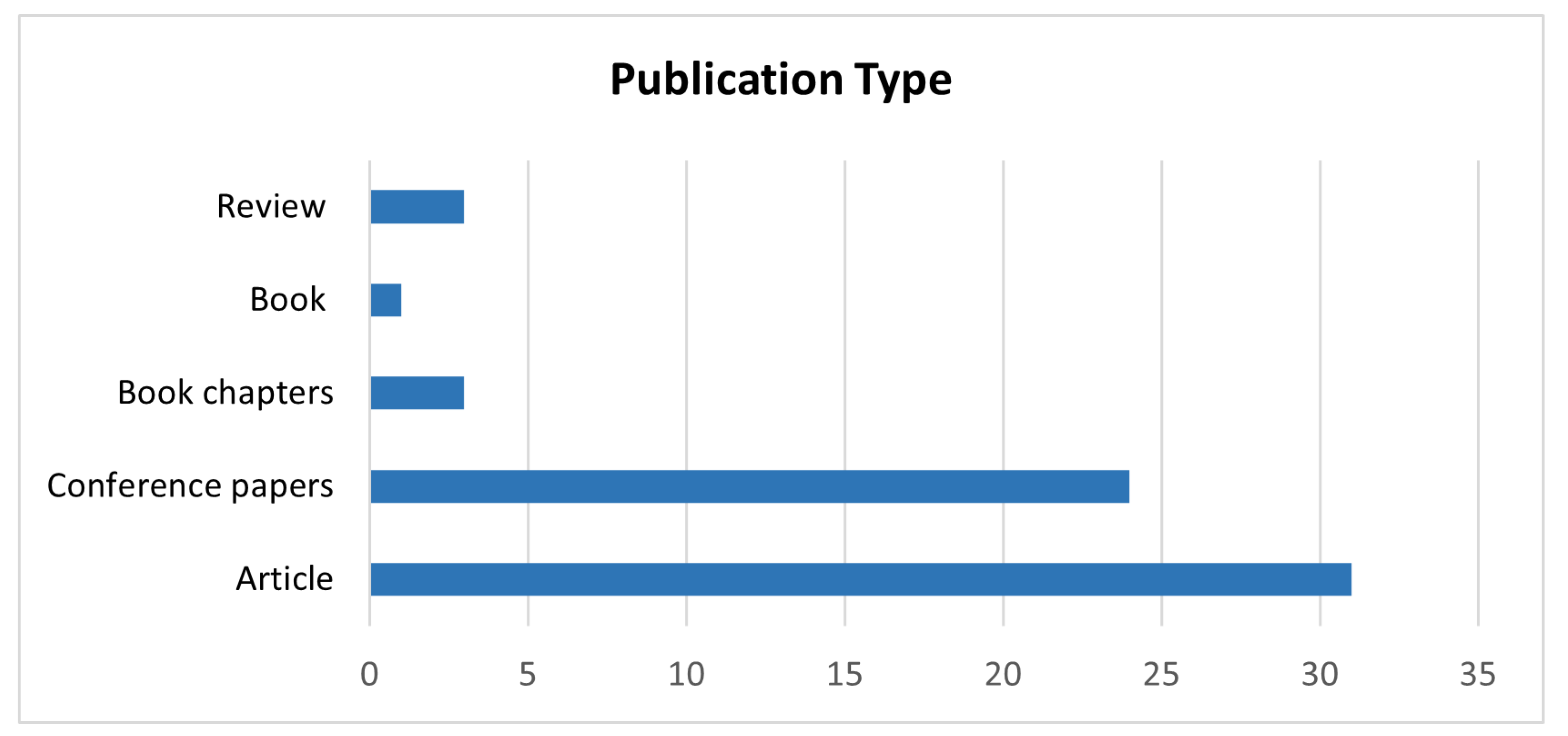
3. Results

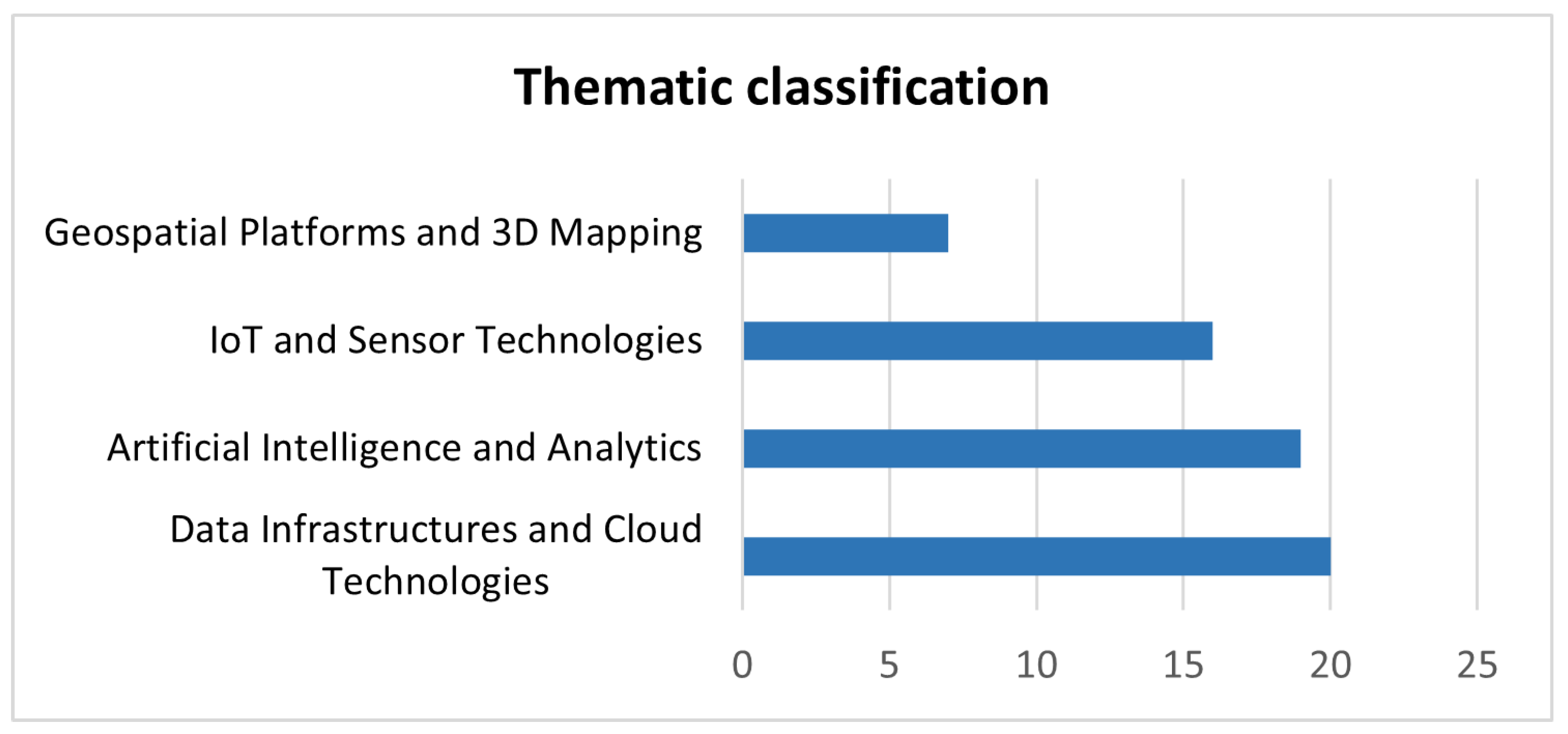
| Technology Domain | Role in SDI | Common Applications | Key Challenges | References |
|---|---|---|---|---|
| IoT and Sensor Technologies | Event-driven architecture integration with SDIs, real-time fusion of sensor data with SDI layers, integration of cloud–fog–edge architecture into SDI workflows, IoT and GIS integration for real-time emergency services | Real-time monitoring, IoT-based sensing, disaster management, smart mobility, environmental sensing, SDI automation | Standardization of event-handling, semantic interoperability, real-time event integration, sensor reliability and communication delays | [8,16,17,20,22,29,33,34,40,47,51,53,55,56,60,61] |
| Geospatial Platforms and 3D Mapping | Integration of real-time sensor platforms with SDIs, participatory urban platform development, SDI-based semantic 3D urban modeling, real-time geospatial feedback integration | Environmental monitoring, dynamic mapping, smart city planning, urban governance | Standardization of platforms, integration latency, citizen engagement, platform usability | [8,13,14,19,21,26,30] |
| Data Infrastructures and Cloud Technologies | Cloud-native or distributed approaches for SDI scaling and interoperability, development of foundational spatial data infrastructures, security framework for distributed SDIs, cloud-based SDI extensions for IoT integration | Land management, disaster response, public health, smart agriculture | Data security, metadata standards, institutional coordination, institutional collaboration | [1,2,3,5,9,16,18,19,31,35,37,38,40,42,44,46,48,58,59,63] |
| Artificial Intelligence and Analytics | Decision support and spatial reasoning, general AI integration in SDI, model training and data repositories, predictive modeling and classification | General smart governance applications, environmental monitoring, model training and benchmarking, agricultural monitoring | General AI deployment challenges, integration complexity, lack of standardization, semantic challenges | [4,10,11,15,23,24,25,28,36,39,40,41,49,50,51,52,54,61,62] |
3.1. IoT and Sensor Technologies
3.2. Geospatial Platforms and 3D Mapping
3.3. Data Infrastructures and Cloud Technologies
3.4. Artificial Intelligence and Analytics
4. Discussion
4.1. IoT and the Development of Event-Driven SDIs
4.2. 3D Platforms and the Semantic Level of Governance
4.3. Cloud Infrastructures and Institutional Constraints
4.4. SDIs as Semantic and Operational Infrastructures
4.5. Governance Models and the Role of SDIs
4.6. Gaps, Inequalities and Strategic Directions
- Geographic inequality—the Global South is underrepresented in both academic discourse and practical implementation. Infrastructure deficits, low digital literacy and funding limitations constrain adoption. The Indonesian initiative “One Map—One Data” [46] is a rare example of the systematic integration of GeoAI in the global South. Broader adoption requires capacity building, open knowledge transfer and investment in local infrastructure.
- Techno-operational inequalities—promising technologies such as semantic web frameworks and explainable AI [25] remain underutilized in real-world systems, and many tools (e.g., visual programming, LiDAR integration) lack standardization or interoperability.
4.7. Towards Inclusive and Adaptive SDI-Driven Governance
5. Conclusions
Author Contributions
Funding
Data Availability Statement
Acknowledgments
Conflicts of Interest
Abbreviations
| AI | Artificial Intelligence |
| ANN | Artificial Neural Network |
| API | Application Programming Interface |
| BIM | Building Information Modeling |
| DGGS | Discrete Global Grid System |
| EO | Earth Observation |
| FAIR | Findable, Accessible, Interoperable, Reusable |
| FGDC | Federal Geographic Data Committee |
| GEE | Google Earth Engine |
| GIS | Geographic Information System |
| INSPIRE | Infrastructure for Spatial Information in the European Community |
| IoT | Internet of Things |
| LiDAR | Light Detection and Ranging |
| LoD | Level of Detail |
| LoRaWAN | Long Range Wide Area Network |
| ML | Machine Learning |
| MVC | Model-View-Controller |
| NSDI | National Spatial Data Infrastructure |
| OGC | Open Geospatial Consortium |
| OLAP | Online Analytical Processing |
| PostGIS | PostgreSQL extension for geospatial data |
| QGIS | Quantum Geographic Information System |
| RDDSS | Real-time Disaster Decision Support System |
| REST | Representational State Transfer |
| SAML | Security Assertion Markup Language |
| SaaS | Software as a Service |
| SDDI | Smart District Data Infrastructure |
| SDI | Spatial Data Infrastructure |
| SHM | Structural Health Monitoring |
| SMACiSYS | Smart Agricultural and Climate Information System |
| SVM | Support Vector Machine |
| UADI | Urban Analytics Data Infrastructure |
Appendix A
| Title | Authors | Year | Thematic Categorization (ML, IoT, AI, SDI) | Geographic Category |
|---|---|---|---|---|
| Building geospatial infrastructure | Dangermond, Jack and Goodchild, Michael F. [2] | 2020 | UNI | AI, IoT, SDI |
| Securing Spatial Data Infrastructures for Distributed Smart City applications and services | Chaturvedi, Kanishk and Matheus, Andreas and Nguyen, Son H. and Kolbe, Thomas H. [16] | 2019 | EUR | AI, IoT, ML, SDI |
| “Mapping” Smart Cities | Loo, Becky P. Y. and Tang, Winnie S. M. [31] | 2019 | ASI | AI, IoT, ML, SDI |
| Extending INSPIRE to the internet of things through sensorthings API | Kotsev, Alexander and Schleidt, Katharina and, Steve and, van and Khalafbeigi, Tania and Sylvain Grellet and Lutz, Michael and Jirka, Simon and Mickaël Beaufils [6] | 2018 | EUR | AI, IoT, ML, SDI |
| Geospatial IoT—the need for event-driven architectures in contemporary spatial data infrastructures | Rieke, Matthes and Bigagli, Lorenzo and Herlé, Stefan and Jirka, Simon and Kotsev, Alexander and Liebig, Thomas and Malewski, Christian and Paschke, Thomas and Stasch, Christoph [8] | 2018 | UNI | AI, IoT, ML, SDI |
| DataCubes: A discrete global grid systems perspective | Purss, Matthew and Peterson, Perry and Strobl, Peter and Dow, Clinton and Sabeur, Zoheir and Gibb, Robert and Ben, Jin [3] | 2019 | UNI | AI, ML, SDI |
| Transport sustainability indicators for an enhanced urban analytics data infrastructure | Reisi, Marzieh and Sabri, Soheil and Agunbiade, Muyiwa and Rajabifard, Abbas and Chen, Yiqun and Kalantari, Mohsen and Keshtiarast, Azadeh and Li, Yan [7] | 2020 | OC | AI, IoT, SDI |
| Towards a training data model for artificial intelligence in earth observation | Yue, Peng and Boyi Shangguan and Hu, Lei and Jiang, Liangcun and Zhang, Chenxiao and Cao, Zhipeng and Pan, Yin-Yin [1] | 2022 | UNI | AI, IoT, SDI |
| A model for big spatial rural data infrastructure in Turkey: Sensor-driven and integrative approach | Iban, Muzaffer Can and Aksu, Oktay [41] | 2020 | ASI | AI, IoT, ML, SDI |
| Enhancing the OGC WPS interface with GeoPipes support for real-time geoprocessing | Herle, Stefan and Jörg Blankenbach [33] | 2018 | EUR | IoT, ML, SDI |
| Global Streetscapes — A comprehensive dataset of 10 million street-level images across 688 cities for urban science and analytics | Hou, Yujun and Quintana, Matias and Khomiakov, Maxim and Yap, Winston and Ouyang, Jiani and Ito, Koichi and Wang, Zeyu and Zhao, Tianhong and Biljecki, Filip [53] | 2024 | UNI | AI, ML |
| Accuracy assessment of digital bare-earth model using ICESat-2 photons: analysis of the FABDEM | Dandabathula, Giribabu and Hari, Rohit and Ghosh, Koushik and Bera, Apurba Kumar and Srivastav, Sushil Kumar [54] | 2023 | UNI | AI, ML, SDI |
| A semantically enriched and web-based 3d energy model visualization and retrieval for smart building implementation using citygml and dynamizer ade | E. Chatzinikolaou and I. Pispidikis and Efi Dimopoulou [24] | 2020 | EUR | AI, IoT, ML, SDI |
| Facilitating Typhoon-Triggered Flood Disaster-Ready Information Delivery Using SDI Services Approach—A Case Study in Hainan | Hu, Lei and Fang, Zhe and Zhang, Mingda and Jiang, Liangcun and Yue, Peng [12] | 2022 | ASI | AI, IoT, ML, SDI |
| Smart cities intelligence system (SMACiSYS) integrating sensor web with spatial data infrastructures (SENSDI) | Bhattacharya, D and Painho, M [14] | 2017 | ASI | AI, IoT, SDI |
| A scoping review on the use, processing and fusion of geographic data in virtual assistants | Granell, Carlos and Pesántez-Cabrera, Paola and Vilches-Blázquez, Luis M and Achig, Rosario and Luaces, Miguel R and Cortiñas-Álvarez, Alejandro and Chayle, Carolina and Morocho, Villie [18] | 2021 | UNI | AI, IoT, SDI |
| Enhancing FAIR Data Services in Agricultural Disaster: A Review | Hu, Lei and Zhang, Chenxiao and Zhang, Mingda and Shi, Yuming and Lu, Jiasheng and Fang, Zhe [55] | 2023 | UNI | AI, ML, SDI |
| Automatic spatial metadata systems–the case of Australian urban research infrastructure network | Taylor & Francis [4] | 2017 | OC | AI, SDI |
| STROVE: spatial data infrastructure enabled cloud–fog–edge computing framework for combating COVID-19 pandemic | Ghosh, Shreya and Mukherjee, Anwesha [42] | 2024 | ASI | AI, IoT, ML, SDI |
| Spatial data supply chains | Varadharajulu, P. and Azeem Saqiq, M. and Yu, F. and McMeekin, D. A. and West, G. and Arnold, L. and Moncrieff, S. [5] | 2015 | OC | AI, ML, SDI |
| Applying discrete global grid systems to sensor networks and the Internet of Things | Purss, Matthew B. J. and Liang, Steve and Gibb, Robert and Samavati, Faramarz and Peterson, Perry and Dow, Clinton and Ben, Jin and Saeedi, Sara [29] | 2017 | UNI | AI, IoT, SDI |
| CloudGanga: Cloud Computing Based SDI Model for Ganga River Basin Management in India | Barik, Rabindra K [43] | 2019 | ASI | AI, ML, SDI |
| Assessing the impact of heavy rainfall on the Newcastle upon Tyne transport network using a geospatial data infrastructure | Wolf, Kristina and Dawson, Richard J. and Mills, Jon P. and Blythe, Phil and Robson, Craig and Morley, Jeremy [9] | 2023 | EUR | AI, IoT, SDI |
| National spatial data infrastructure (nsdi) of Bangladesh-development, progress and way forward | Rahman, M. M. and Szabó, G. [20] | 2020 | ASI | AI, SDI |
| Development of repository of deep neural networks for the analysis of geospatial data | Yamashkina, E and Kovalenko, S and Platonova, O [44] | 2021 | ASI | AI, ML, SDI |
| Indoor localization for 3d mobile cadastral mapping using machine learning techniques | Potsiou, C. and Doulamis, N. and Bakalos, N. and Gkeli, M. and Ioannidis, C. [34] | 2020 | EUR | AI, ML, SDI |
| Online Atlas as Decision Support System for Biomass Potential Assessment | Karabegovic, Almir and Mirza Ponjavic [35] | 2020 | EUR | AI, SDI |
| Smart 3d building infrastructures: linking Gis with other domains | Knoth, Laura and Manfred Mittlboeck and Bernhard Vockner [23] | 2016 | EUR | AI, IoT, ML, SDI |
| Development of a framework for implementing 3D spatial data infrastructure in Oman—Issues and challenges | Al Kalbani, K. and Abdul Rahman, A. and Al Awadhi, T. and Alshannaq, F. [45] | 2018 | ASI | AI, IoT, SDI |
| INSPIRE standards as a framework for artificial intelligence applications: A landslide example | Roberti, Gioachino and McGregor, Jacob and Lam, Sharon and Bigelow, David and Boyko, Blake and Ahern, Chris and Wang, Victoria and Barnhart, Bryan and Smyth, Clinton and Poole, David and Richard, Stephen [25] | 2020 | EUR | AI, SDI |
| Specifying the computation viewpoints for a corporate spatial data infrastructure using ICA’s formal model | Oliveira, Italo Lopes and Jugurta Lisboa-Filho and Moura, Carlos Alberto and Gonçalves, Alexander [30] | 2016 | AMER | AI, SDI |
| An integrated service-based solution addressing the modernised common agriculture policy regulations and environmental perspectives | Karagiannopoulou, Katerina and Tsiakos, Chrisovalantis and Tsimiklis, Georgios and Tsertou, Athanasia and Amditis, Angelos and Milcinski, Grega and Vesel, Nejc and Protic, Dragutin and Kilibarda, Milan and Tsakiridis, Nikolaos and Chondronasios, Apostolos [22] | 2020 | EUR | AI, SDI |
| A novel computational knowledge-base framework for visualization and quantification of geospatial metadata in spatial data infrastructures | Rajaram, Gangothri and Harish Chandra Karnatak and Venkatraman, Swaminathan and Manjula, K R and Kannan Krithivasan [13] | 2018 | ASI | AI, ML, SDI |
| Multimodal sensing for sustainable structural health monitoring of critical infrastructures and built environment | Soldovieri, F and Ponzo, Felice and Ditommaso, Rocco and Cuomo, Vincenzo [28] | 2021 | EUR | AI, IoT, SDI |
| Spatial Data Infrastructure Integrated with Geospatial Artificial Intelligence: A Systematic Literature Review | Yudha Setya Nugroho and Suhono Harso Supangkat [46] | 2021 | ASI | AI, SDI |
| Spatial data integration in heterogeneous information systems’ environment | M. Ponjavic and Karabegovic, A and E. Ferhatbegovic and Besic, I [46] | 2019 | EUR | AI, IoT, SDI |
| Smart data infrastructure for smart and sustainable cities | Moshrefzadeh, M and Kolbe, T [36] | 2016 | EUR | AI, IoT, ML, SDI |
| GIS and Geospatial Studies in Disaster Management | Ghosh, Chandan [56] | 2023 | UNI | AI, IoT, ML, SDI |
| Prototype of a Centralized Alert and Emergency System for Digital Terrestrial Television in Ecuador | Olmedo, Gonzalo and Acosta, Freddy and Villamarín, Diego and Santander, Fabián and Achig, Rosario and Morocho, Villie [62] | 2021 | AMER | AI, IoT, SDI |
| Examining satellite images market stability using the Records theory: Evidence from French spatial data infrastructures | Jabbour, Chady and Anis Hoayek and Maurel, Pierre and Zaher Khraibani and Ghalayini, Latifa [38] | 2021 | EUR | AI, ML, SDI |
| Standards in geospatial information management and spatial data infrastructures | WORLD, SGEM [57] | 2018 | UNI | AI, IoT, ML, SDI |
| How to Integrate AI into Spatial Data Infrastructures: Evolution of the UCuenca SDI | Morocho, Villie and Pacurucu-Cáceres, Natalia and Vivanco, Lorena and Santander, Fabian and Bustamante, Juan and Achig, Rosario [26] | 2024 | AMER | AI, ML, SDI |
| Application of Visual Programming Methods to the Design of Neural Networks | Yamashkina, E. O. and Yamashkin, S. A. and Platonova, Olga V. and Kovalenko, S. M.[47] | 2021 | ASI | AI, ML, SDI |
| Data Mining, Machine Learning and Spatial Data Infrastructures for Scenario Modelling | Sang, Neil and Aitkenhead, Matthew [58] | 2020 | UNI | AI, ML, SDI |
| Odyssey: A Spatial Data Infrastructure for Archaeology | Sá, Rafael and Gonçalves, Luís Jorge and Medina, Jorge and Neves, António and Marsh, Fernando and Al-Rawi, Mohammed and Canedo, Daniel and Dias, Rita and Pereiro, Tiago and Hipólito, João and da Silva, Alberto Lago and Fonte, João and Seco, Luís Gonçalves and Vázquez, Marta and Moreira, Jose [59] | 2024 | UNI | AI, ML, SDI |
| Smart Emergency Services Using Geographical Information System and Internet of Things | Saeedi, Reyhaneh and Aghamohammadi, Hossein and Alesheikh, Ali Asghar and Vafaeinejad, Alireza [48] | 2024 | ASI | AI, IoT, SDI |
| Conceptual modelling of sensor-based geographic data: interoperable approach with real-time air quality index (AQI) dashboard | Rabia Bovkir and Arif Cagdas Aydinoglu [49] | 2024 | ASI | AI, IoT, SDI |
| Management of natural-social-production systems based on the Internet of Things concept: a geoportal approach | Yamashkin, S.A and Yamashkin, Anatoliy [50] | 2023 | ASI | AI, IoT, SDI |
| EarlyDike: Sensor and Spatial Data Infrastructure for a sensor- and risk-based early warning system for sea dikes; [EarlyDike: Sensor- und Geodateninfrastruktur für ein sensor- und risikobasiertes Frühwarnsystem für Seedeiche] | Herle, Stefan and Becker, Ralf and Blankenbach, Jörg and Mulckau, Alexander and Lehfeldt, Rainer and im, Forschung [39] | 2021 | EUR | IoT, SDI |
| The Influence of Transportation Accessibility on Traffic Volumes in South Korea: An Extreme Gradient Boosting Approach | Lee, Sangwan and Yang, Jicheol and Cho, Kuk and Cho, Dooyong [11] | 2023 | ASI | AI, IoT, ML, SDI |
| Geoportals in Solving the Problem of Natural Hazards Monitoring | Yamashkin, Stanislav A and Yamashkin, A A and Rotanov, A S and Tepaeva, Yu E and Yamashkina, E O and Kovalenko, S M [51] | 2024 | ASI | AI, ML, SDI |
| The Potential of Google Earth Engine as Decision Support for Agricultural and Forestry Planning Policies in Latin America and the Caribbean: A Meta-Analysis and Systematic Review | Ríos-Mesa, Andrés Felipe and Palacio-Piedrahíta, Juan Carlos and Zartha-Sossa, Jhon Wilder and Mesas-Carrascosa, Francisco Javier and Hincapie-Reyes, Roberto Carlos [63] | 2024 | AMER | AI, IoT, ML, SDI |
| Evolving patterns of spatial data infrastructures for modeling of data ecosystems; [Patrones evolutivos de infraestructuras de datos espaciales para el modelado de ecosistemas de datos] | Delgado Fernández, Tatiana and, Luis and Crompvoets, Joep and Iglesias, Rafael Cruz and, Denise and Guillermo, González Suárez [21] | 2024 | UNI | AI, IoT, SDI |
| Technology trends for spatial data infrastructure in africa | Mwungu, Collins and Mulaku, Galcano and Siriba, David [27] | 2018 | AFR | AI, IoT, SDI |
| Advances in Geospatial Technologies for Natural Resource Management | Dwivedi, Ravi Shankar [60] | 2024 | UNI | AI, IoT, ML, SDI |
| Estimation of road accident severity using k-means clustering of spatio-temporal data with backend spatial data infrastructure | Mishra, Moumita and Maitra, Bhargab and Ghosh, Soumya [52] | 2024 | ASI | AI, IoT, ML, SDI |
| Implementation of Geoportals as a Problem-Oriented Tool for Managing Natural-Social-Production Systems | Yamashkin, S A and Yamashkin, A A and Radovanović, M M and Petrović, M D and Yamashkina, E O [17] | 2024 | EUR | AI, IoT, SDI |
| GeoS4S module real-time geospatial applications | Mittlboeck, M and Belgiu, M [61] | 2018 | UNI | AI, IoT, SDI |
| From Geospatial Data Cube to AI Cube: the Open Geospatial Engine (OGE) Approach | Yue, Peng and Wang, Kaixuan and Xu, Hanwen and Gong, Jianya and Xiang, Longgang [10] | 2024 | UNI | AI, ML, SDI |
| Improving early prediction of crop yield in Spanish olive groves using satellite imagery and machine learning | Ramos, M Isabel and Cubillas, Juan J and Córdoba, Ruth M and Ortega, Lidia M [15] | 2025 | EUR | AI, ML, SDI |
| Risk-Oriented Geoportal Systems and the Internet of Things as a Tool for Managing Metageosystems | Yamashkin, Stanislav and Yamashkin, Anatoliy and Radovanović, Milan and Petrović, Marko and Yamashkina, Ekaterina [40] | 2023 | EUR | AI, IoT, SDI |
| Application of GIS in the Maritime-Port Sector: A Systematic Review | Crismeire Isbaex and, Francisco and Batista, Teresa [19] | 2025 | UNI | AI, ML, SDI |
References
- Yue, P.; Shangguan, B.; Hu, L.; Jiang, L.; Zhang, C.; Cao, Z.; Pan, Y.Y. Towards a training data model for artificial intelligence in earth observation. Int. J. Geogr. Inf. Sci. 2022, 36, 2113–2137. [Google Scholar] [CrossRef]
- Dangermond, J.; Goodchild, M.F. Building geospatial infrastructure. Geo-Spat. Inf. Sci. 2019, 23, 1–9. [Google Scholar] [CrossRef]
- Purss, M.; Peterson, P.; Strobl, P.; Dow, C.; Sabeur, Z.; Gibb, R.; Ben, J. Datacubes: A Discrete Global Grid Systems Perspective. Cartogr. Int. J. Geogr. Inf. Geovisualization 2019, 54, 63–71. [Google Scholar] [CrossRef]
- Kalantari, M.; Rajabifard, A.; Olfat, H.; Pettit, C.; Keshtiarast, A. Automatic spatial metadata systems—The case of Australian urban research infrastructure network. Cartogr. Geogr. Inf. Sci. 2016, 44, 327–337. [Google Scholar] [CrossRef]
- Varadharajulu, P.; Azeem Saqiq, M.; Yu, F.; McMeekin, D.A.; West, G.; Arnold, L.; Moncrieff, S. Spatial Data Supply Chains. Int. Arch. Photogramm. Remote. Sens. Spat. Inf. Sci. 2015, XL-4/W7, 41–45. [Google Scholar] [CrossRef]
- Kotsev, A.; Schleidt, K.; Liang, S.; Van der Schaaf, H.; Khalafbeigi, T.; Grellet, S.; Lutz, M.; Jirka, S.; Beaufils, M. Extending INSPIRE to the Internet of Things through SensorThings API. Geosciences 2018, 8, 221. [Google Scholar] [CrossRef]
- Reisi, M.; Sabri, S.; Agunbiade, M.; Rajabifard, A.; Chen, Y.; Kalantari, M.; Keshtiarast, A.; Li, Y. Transport sustainability indicators for an enhanced urban analytics data infrastructure. Sustain. Cities Soc. 2020, 59, 102095. [Google Scholar] [CrossRef]
- Rieke, M.; Bigagli, L.; Herlé, S.; Jirka, S.; Kotsev, A.; Liebig, T.; Malewski, C.; Paschke, T.; Stasch, C. Geospatial IoT—The Need for Event-Driven Architectures in Contemporary Spatial Data Infrastructures. ISPRS Int. J. Geo-Inf. 2018, 7, 385. [Google Scholar] [CrossRef]
- Wolf, K.; Dawson, R.J.; Mills, J.P.; Blythe, P.; Robson, C.; Morley, J. Assessing the impact of heavy rainfall on the Newcastle upon Tyne transport network using a geospatial data infrastructure. Resilient Cities Struct. 2023, 2, 24–41. [Google Scholar] [CrossRef]
- Yue, P.; Wang, K.; Xu, H.; Gong, J.; Xiang, L. From Geospatial Data Cube to AI Cube: The Open Geospatial Engine (OGE) Approach. ISPRS Ann. Photogramm. Remote. Sens. Spat. Inf. Sci. 2024, X-4-2024, 441–446. [Google Scholar] [CrossRef]
- Lee, S.; Yang, J.; Cho, K.; Cho, D. The Influence of Transportation Accessibility on Traffic Volumes in South Korea: An Extreme Gradient Boosting Approach. Urban Sci. 2023, 7, 91. [Google Scholar] [CrossRef]
- Hu, L.; Fang, Z.; Zhang, M.; Jiang, L.; Yue, P. Facilitating Typhoon-Triggered Flood Disaster-Ready Information Delivery Using SDI Services Approach—A Case Study in Hainan. Remote Sens. 2022, 14, 1832. [Google Scholar] [CrossRef]
- Rajaram, G.; Karnatak, H.C.; Venkatraman, S.; Manjula, K.R.; Krithivasan, K. A novel computational knowledge-base framework for visualization and quantification of geospatial metadata in spatial data infrastructures. GeoInformatica 2018, 22, 269–305. [Google Scholar] [CrossRef]
- Bhattacharya, D.; Painho, M. Smart Cities Intelligence System (Smacisys) Integrating Sensor Web with Spatial Data Infrastructures (Sensdi). ISPRS Ann. Photogramm. Remote. Sens. Spat. Inf. Sci. 2017, IV-4/W3, 21–28. [Google Scholar] [CrossRef]
- Ramos, M.I.; Cubillas, J.J.; Córdoba, R.M.; Ortega, L.M. Improving early prediction of crop yield in Spanish olive groves using satellite imagery and machine learning. PLoS ONE 2025, 20, e0311530. [Google Scholar] [CrossRef] [PubMed]
- Chaturvedi, K.; Matheus, A.; Nguyen, S.H.; Kolbe, T.H. Securing Spatial Data Infrastructures for Distributed Smart City applications and services. Future Gener. Comput. Syst. 2019, 101, 723–736. [Google Scholar] [CrossRef]
- Yamashkin, S.A.; Yamashkin, A.A.; Radovanović, M.M.; Petrović, M.D.; Yamashkina, E.O. Implementation of Geoportals as a Problem-Oriented Tool for Managing Natural-Social-Production Systems. In Software Engineering Methods in Systems and Network Systems; Springer: Cham, Switzerland, 2024; pp. 94–104. [Google Scholar] [CrossRef]
- Granell, C.; Pesántez-Cabrera, P.; Vilches-Blázquez, L.M.; Achig, R.; Luaces, M.R.; Cortiñas-Álvarez, A.; Chayle, C.; Morocho, V. A scoping review on the use, processing and fusion of geographic data in virtual assistants. Trans. GIS 2021, 25, 1784–1808. [Google Scholar] [CrossRef]
- Isbaex, C.; dos Reis Fernandes Costa, F.; Batista, T. Application of GIS in the Maritime-Port Sector: A Systematic Review. Sustainability 2025, 17, 3386. [Google Scholar] [CrossRef]
- Rahman, M.M.; Szabó, G. National spatial data infrastructure (nsdi) of Bangladesh-development, progress and way forward. ISPRS Ann. Photogramm. Remote. Sens. Spat. Inf. Sci. 2020, V-4-2020, 131–138. [Google Scholar] [CrossRef]
- Delgado Fernández, T.; Capote Fernández, J.L.; Crompvoets, J.; Iglesias, R.C.D.; Guillermo, G.S. Patrones evolutivos de infraestructuras de datos espaciales para el modelado de ecosistemas de datos. An. De La Acad. De Cienc. De Cuba 2024, 14, e1539. [Google Scholar]
- Karagiannopoulou, K.; Tsiakos, C.; Tsimiklis, G.; Tsertou, A.; Amditis, A.; Milcinski, G.; Vesel, N.; Protic, D.; Kilibarda, M.; Tsakiridis, N.; et al. An integrated servicebased solution addressing the modernised common agriculture policy regulations and environmental perspectives. In Proceedings of the Remote Sensing for Agriculture, Ecosystems, and Hydrology, Online Only, UK, 21–25 September 2020. [Google Scholar] [CrossRef]
- Knoth, L.; Mittlboeck, M.; Vockner, B. Smart 3D Building Infrastructures: Linking Gis with Other Domains. ISPRS Ann. Photogramm. Remote. Sens. Spat. Inf. Sci. 2016, IV-2/W1, 187–194. [Google Scholar] [CrossRef]
- Chatzinikolaou, E.; Pispidikis, I.; Dimopoulou, E. A Semantically Enriched and Web-Based 3d Energy Model Visualization and Retrieval for Smart Building Implementation Using Citygml and Dynamizer ADE. ISPRS Ann. Photogramm. Remote. Sens. Spat. Inf. Sci. 2020, VI-4/W1-2020, 53–60. [Google Scholar] [CrossRef]
- Roberti, G.; McGregor, J.; Lam, S.; Bigelow, D.; Boyko, B.; Ahern, C.; Wang, V.; Barnhart, B.; Smyth, C.; Poole, D.; et al. INSPIRE standards as a framework for artificial intelligence applications: A landslide example. Nat. Hazards Earth Syst. Sci. 2020, 20, 3455–3483. [Google Scholar] [CrossRef]
- Morocho, V.; Pacurucu-Cáceres, N.; Vivanco, L.; Santander, F.; Bustamante, J.; Achig, R. How to Integrate AI into Spatial Data Infrastructures: Evolution of the UCuenca SDI. In Lecture Notes in Geoinformation and Cartography; Springer: Cham, Switzerland, 2024; pp. 101–117. [Google Scholar] [CrossRef]
- Mwungu, C.; Mulaku, G.; Siriba, D. Technology Trends for Spatial Data Infrastructure in Africa. Civ. Eng. Archit. 2018, 6, 189–204. [Google Scholar] [CrossRef]
- Soldovieri, F.; Ponzo, F.; Ditommaso, R.; Cuomo, V. Multimodal sensing for sustainable structural health monitoring of critical infrastructures and built environment. In Proceedings of the Multimodal Sensing and Artificial Intelligence: Technologies and Applications II, Online Only, Germany, 21–25 June 2021; p. 4. [Google Scholar] [CrossRef]
- Purss, M.B.J.; Liang, S.; Gibb, R.; Samavati, F.; Peterson, P.; Dow, C.; Ben, J.; Saeedi, S. Applying discrete global grid systems to sensor networks and the Internet of Things. In Proceedings of the 2017 IEEE International Geoscience and Remote Sensing Symposium (IGARSS), Fort Worth, TX, USA, 23–28 July 2017; pp. 5581–5583. [Google Scholar] [CrossRef]
- Oliveira, I.L.; Lisboa-Filho, J.; Moura, C.A.; Gonçalves, A. Specifying the Computation Viewpoints for a Corporate Spatial Data Infrastructure Using ICA’s Formal Model. In Lecture Notes in Computer Science; Springer: Cham, Switzerland, 2016; pp. 275–289. [Google Scholar] [CrossRef]
- Loo, B.P.Y.; Tang, W.S.M. “Mapping” Smart Cities. J. Urban Technol. 2019, 26, 129–146. [Google Scholar] [CrossRef]
- ISO/TR 19120:2001; Geographic Information—Functional Standards. International Organization for Standardization (ISO): Geneva, Switzerland, 2001.
- Herle, S.; Blankenbach, J. Enhancing the OGC WPS interface with GeoPipes support for real-time geoprocessing. Int. J. Digit. Earth 2017, 11, 48–63. [Google Scholar] [CrossRef]
- Potsiou, C.; Doulamis, N.; Bakalos, N.; Gkeli, M.; Ioannidis, C. Indoor Localization for 3D Mobile Cadastral Mapping Using Machine Learning Techniques. ISPRS Ann. Photogramm. Remote. Sens. Spat. Inf. Sci. 2020, VI-4/W1-2020, 159–166. [Google Scholar] [CrossRef]
- Karabegovic, A.; Ponjavic, M. Online Atlas as Decision Support System for Biomass Potential Assessment. In Proceedings of the 2020 19th International Symposium INFOTEH-JAHORINA (INFOTEH), East Sarajevo, Bosnia and Herzegovina, 18–20 March 2020; pp. 1–6. [Google Scholar] [CrossRef]
- Ponjavic, M.; Karabegovic, A.; Ferhatbegovic, E.; Besic, I. Spatial data integration in heterogeneous information systems’ environment. In Proceedings of the 2019 42nd International Convention on Information and Communication Technology, Electronics and Microelectronics (MIPRO), Opatija, Croatia, 20–24 May 2019; pp. 1559–1564. [Google Scholar] [CrossRef]
- Moshrefzadeh, M.; Kolbe, T. Smart Data Infrastructure for Smart and Sustainable Cities. In Proceedings of the Event 13th International Conference on Design and Decision Support Systems in Architecture and Urban Planning, DDSS 2016, Eindhoven, The Netherlands, 27–28 June 2016. [Google Scholar]
- Jabbour, C.; Hoayek, A.; Maurel, P.; Khraibani, Z.; Ghalayini, L. Examining satellite images market stability using the Records theory: Evidence from French spatial data infrastructures. J. Spat. Inf. Sci. 2021, 22, 61–82. [Google Scholar] [CrossRef]
- Herle, S.; Becker, R.; Blankenbach, J.; Mulckau, A.; Lehfeldt, R.; Im, F. EarlyDike: Sensor & Geodateninfrastruktur für ein sensorund risikobasiertes Frühwarnsystem für Seedeiche. In Die Küste, 90 EarlyDike; Federal Institute of Waterways: Karlsruhe, Germany, 2021; pp. 161–197. [Google Scholar]
- Yamashkin, S.; Yamashkin, A.; Radovanović, M.; Petrović, M.; Yamashkina, E. Risk-Oriented Geoportal Systems and the Internet of Things as a Tool for Managing Metageosystems. Int. J. Eng. Trends Technol. 2023, 71, 159–170. [Google Scholar] [CrossRef]
- Iban, M.C.; Aksu, O. A model for big spatial rural data infrastructure in Turkey: Sensor-driven and integrative approach. Land Use Policy 2020, 91, 104376. [Google Scholar] [CrossRef]
- Ghosh, S.; Mukherjee, A. STROVE: Spatial data infrastructure enabled cloud–fog–edge computing framework for combating COVID-19 pandemic. Innov. Syst. Softw. Eng. 2022, 20, 27–743. [Google Scholar] [CrossRef] [PubMed]
- Barik, R.K. CloudGanga: Cloud Computing Based SDI Model for Ganga River Basin Management in India. Int. J. Agric. Environ. Inf. Syst. (IJAEIS) 2017, 8, 54–71. [Google Scholar] [CrossRef]
- Yamashkina, E.; Kovalenko, S.; Platonova, O. Development of repository of deep neural networks for the analysis of geospatial data. IOP Conf. Ser. Mater. Sci. Eng. 2021, 1047, 012124. [Google Scholar] [CrossRef]
- Al Kalbani, K.; Abdul Rahman, A.; Al Awadhi, T.; Alshannaq, F. Development of a framework for implementing 3D spatial data infrastructure in Oman - Issues and challenges. Int. Arch. Photogramm. Remote. Sens. Spat. Inf. Sci. 2018, XLII-4/W9, 243–246. [Google Scholar] [CrossRef]
- Nugroho, Y.S.; Supangkat, S.H. Spatial Data Infrastructure Integrated with Geospatial Artificial Intelligence: A Systematic Literature Review. In Proceedings of the 2021 International Conference on ICT for Smart Society (ICISS), Bandung, Indonesia, 2–4 August 2021; Volume 4, pp. 1–5. [Google Scholar] [CrossRef]
- Yamashkina, E.O.; Yamashkin, S.A.; Platonova, O.V.; Kovalenko, S.M. Application of Visual Programming Methods to the Design of Neural Networks. In Lecture Notes in Networks and Systems; Springer: Cham, Switzerland, 2021; pp. 680–689. [Google Scholar] [CrossRef]
- Saeedi, R.; Aghamohammadi, H.; Alesheikh, A.A.; Vafaeinejad, A. Smart emergency services using geographical information system and Internet of Things. Iran. J. Remote Sens. GIS 2024, 16, 159–178. [Google Scholar] [CrossRef]
- Bovkir, R.; Aydinoglu, A.C. Conceptual modelling of sensor-based geographic data: Interoperable approach with real-time air quality index (AQI) dashboard. Earth Sci. Inform. 2024, 17, 5317–5333. [Google Scholar] [CrossRef]
- Yamashkin, S.; Yamashkin, A. Management of natural-social-production systems based on the Internet of Things concept: A geoportal approach. Geod. Cartogr. 2023, 999, 34–43. [Google Scholar] [CrossRef]
- Yamashkin, S.A.; Yamashkin, A.A.; Rotanov, A.S.; Tepaeva, Y.E.; Yamashkina, E.O.; Kovalenko, S.M. Geoportals in Solving the Problem of Natural Hazards Monitoring. In Lecture Notes in Networks and Systems; Springer: Cham, Switzerland, 2024; pp. 142–158. [Google Scholar] [CrossRef]
- Mishra, M.; Maitra, B.; Ghosh, S. Estimation of Road Accident Severity Using KMeans Clustering of SpatioTemporal Data with Backend Spatial Data Infrastructure. In Proceedings of the 2024 IEEE International Geoscience and Remote Sensing, Athens, Greece, 7–12 July 2024; pp. 3142–3146. [Google Scholar] [CrossRef]
- Hou, Y.; Quintana, M.; Khomiakov, M.; Yap, W.; Ouyang, J.; Ito, K.; Wang, Z.; Zhao, T.; Biljecki, F. Global Streetscapes—A comprehensive dataset of 10 million street-level images across 688 cities for urban science and analytics. ISPRS J. Photogramm. Remote Sens. 2024, 215, 216–238. [Google Scholar] [CrossRef]
- Dandabathula, G.; Hari, R.; Ghosh, K.; Bera, A.K.; Srivastav, S.K. Accuracy assessment of digital bare-earth model using ICESat-2 photons: Analysis of the FABDEM. Model. Earth Syst. Environ. 2022, 9, 2677–2694. [Google Scholar] [CrossRef]
- Hu, L.; Zhang, C.; Zhang, M.; Shi, Y.; Lu, J.; Fang, Z. Enhancing FAIR Data Services in Agricultural Disaster: A Review. Remote Sens. 2023, 15, 2024. [Google Scholar] [CrossRef]
- Ghosh, C. GIS and Geospatial Studies in Disaster Management. In International Handbook of Disaster Research; Springer: Singapore, 2023; pp. 701–708. [Google Scholar] [CrossRef]
- World, S. EPS eLibrary: Standards in Geospatial Information Management and Spatial Data Infrastructures. In Proceedings of the 18th International Multidisciplinary Scientific GeoConference SGEM 2018, Vienna, Austria, 3–6 December 2018. [Google Scholar]
- Sang, N.; Aitkenhead, M. Data Mining, Machine Learning and Spatial Data Infrastructures for Scenario Modelling; Cambridge University Press: Cambridge, UK, 2020; pp. 276–304. [Google Scholar]
- Sá, R.; Gonçalves, L.J.; Medina, J.; Neves, A.; Marsh, F.; Al-Rawi, M.; Canedo, D.; Dias, R.; Pereiro, T.; Hipólito, J.; et al. Odyssey: A Spatial Data Infrastructure for Archaeology. J. Comput. Appl. Archaeol. 2024, 7, 225–236. [Google Scholar] [CrossRef]
- Dwivedi, R.S. Advances in Geospatial Technologies for Natural Resource Management, 1st ed.; CRC Press: Boca Raton, FL, USA, 2025. [Google Scholar]
- Mittlboeck, M.; Belgiu, M. GeoS4S module realtime geospatial applications. Int. J. Geoinformatics 2018, 14, 47–50. [Google Scholar]
- Olmedo, G.; Acosta, F.; Villamarín, D.; Santander, F.; Achig, R.; Morocho, V. Prototype of a Centralized Alert and Emergency System for Digital Terrestrial Television in Ecuador. In Advances in Intelligent Systems and Computing; Springer: Cham, Switzerland, 2021; pp. 191–201. [Google Scholar] [CrossRef]
- Ríos-Mesa, A.F.; Palacio-Piedrahíta, J.C.; Zartha-Sossa, J.W.; Mesas-Carrascosa, F.J.; Hincapie-Reyes, R.C. The Potential of Google Earth Engine as Decision Support for Agricultural and Forestry Planning Policies in Latin America and the Caribbean: A Meta-Analysis and Systematic Review. J. Sustain. For. 2024, 43, 99–128. [Google Scholar] [CrossRef]


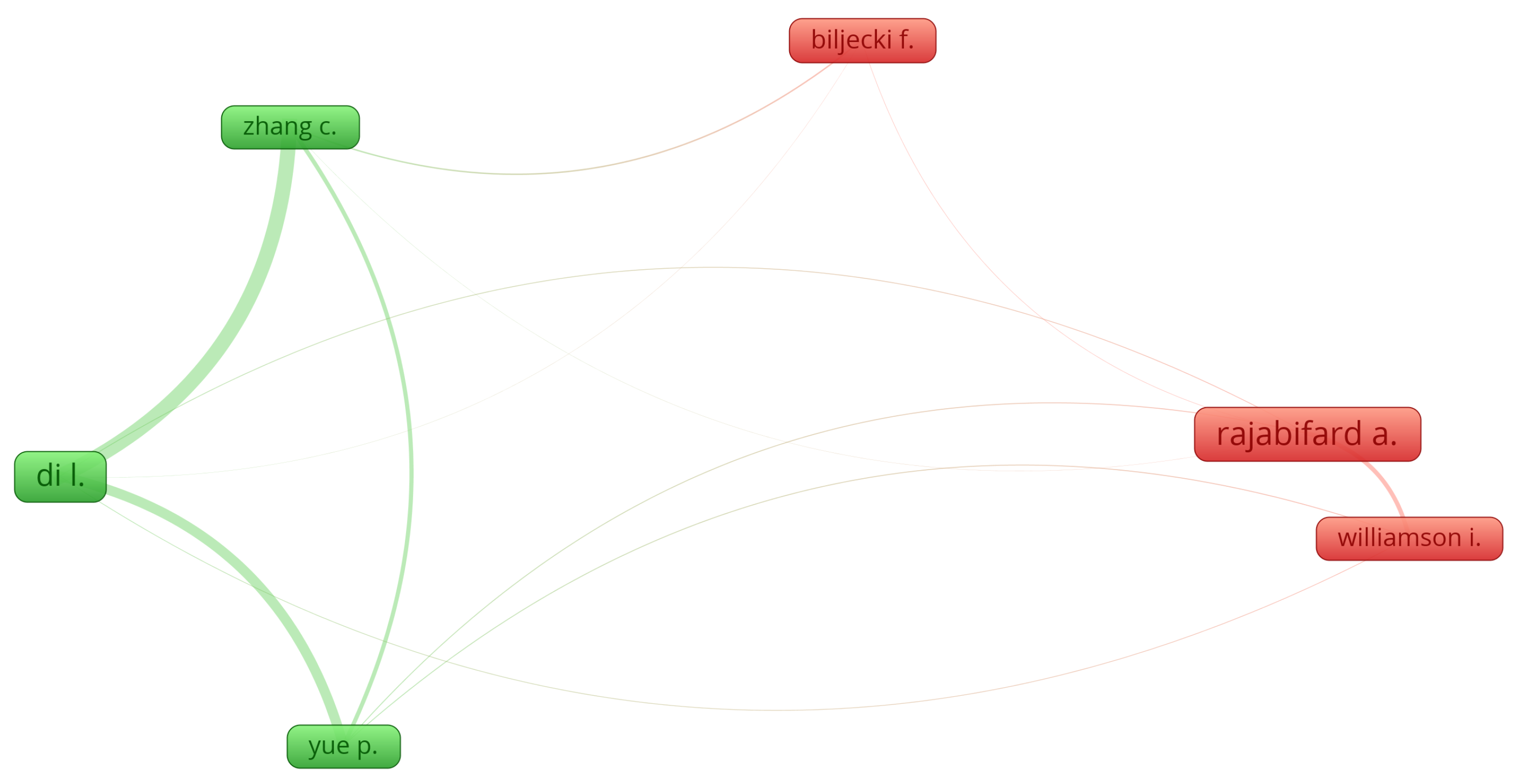
| Author | Citations | Total Link Strength |
|---|---|---|
| Di Liping | 33 | 300 |
| Zhang Chao | 18 | 233 |
| Yue Peng | 18 | 180 |
| Rajabifard Abbas | 39 | 74 |
| Williamson Ian | 17 | 67 |
| Biljecki Filip | 21 | 22 |
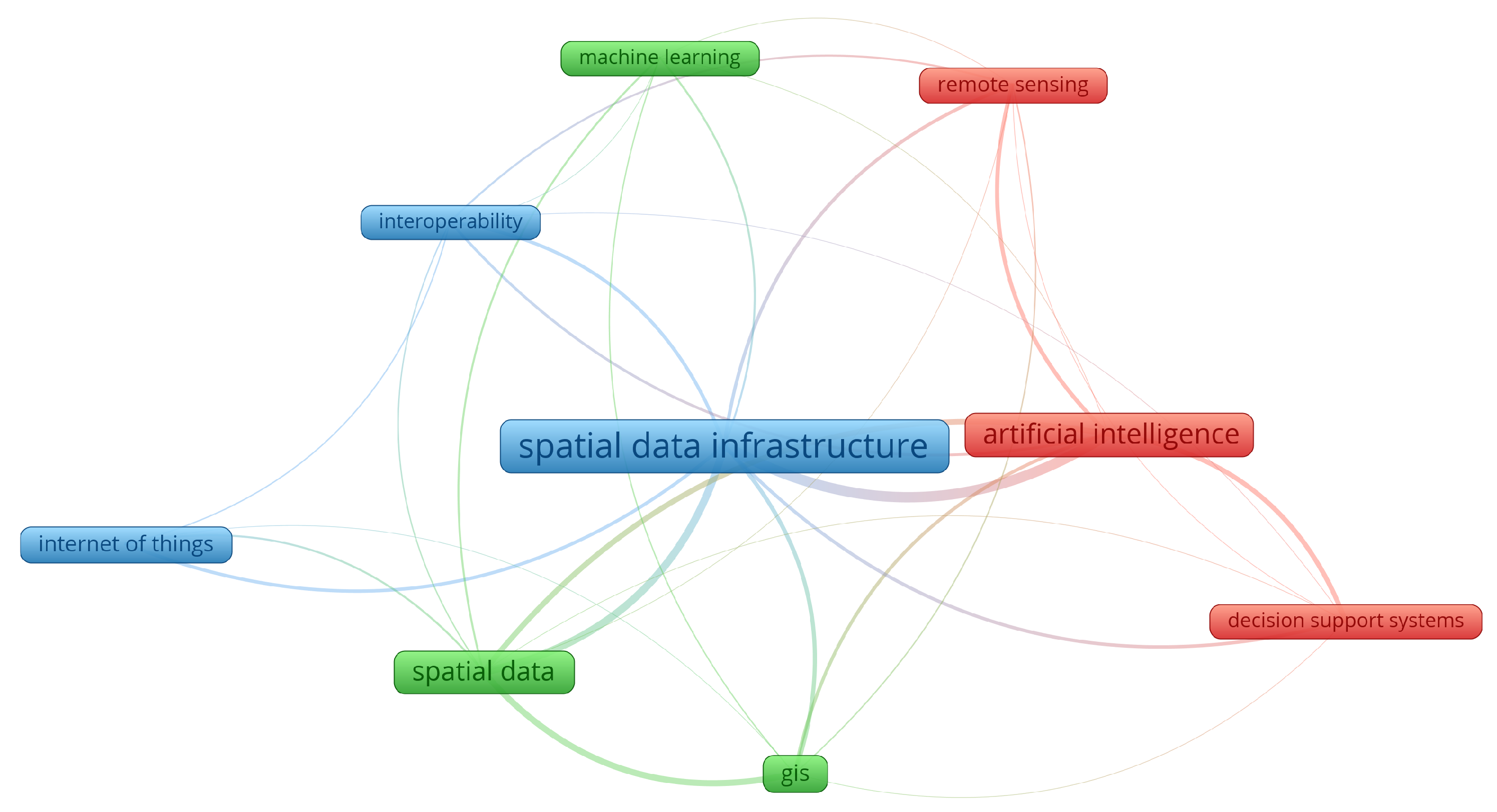
| Keyword | Occurrences | Total Link Strength |
|---|---|---|
| spatial data infrastructure | 37 | 55 |
| artificial intelligence | 23 | 46 |
| spatial data | 21 | 38 |
| GIS | 13 | 26 |
| remote sensing | 9 | 19 |
| interoperability | 7 | 18 |
| decision support systems | 7 | 16 |
| internet of things | 11 | 11 |
| machine learning | 7 | 11 |
Disclaimer/Publisher’s Note: The statements, opinions and data contained in all publications are solely those of the individual author(s) and contributor(s) and not of MDPI and/or the editor(s). MDPI and/or the editor(s) disclaim responsibility for any injury to people or property resulting from any ideas, methods, instructions or products referred to in the content. |
© 2025 by the authors. Licensee MDPI, Basel, Switzerland. This article is an open access article distributed under the terms and conditions of the Creative Commons Attribution (CC BY) license (https://creativecommons.org/licenses/by/4.0/).
Share and Cite
Sofianopoulos, S.; Faka, A.; Chalkias, C. SDI-Enabled Smart Governance: A Review (2015–2025) of IoT, AI and Geospatial Technologies—Applications and Challenges. Land 2025, 14, 1399. https://doi.org/10.3390/land14071399
Sofianopoulos S, Faka A, Chalkias C. SDI-Enabled Smart Governance: A Review (2015–2025) of IoT, AI and Geospatial Technologies—Applications and Challenges. Land. 2025; 14(7):1399. https://doi.org/10.3390/land14071399
Chicago/Turabian StyleSofianopoulos, Sofianos, Antigoni Faka, and Christos Chalkias. 2025. "SDI-Enabled Smart Governance: A Review (2015–2025) of IoT, AI and Geospatial Technologies—Applications and Challenges" Land 14, no. 7: 1399. https://doi.org/10.3390/land14071399
APA StyleSofianopoulos, S., Faka, A., & Chalkias, C. (2025). SDI-Enabled Smart Governance: A Review (2015–2025) of IoT, AI and Geospatial Technologies—Applications and Challenges. Land, 14(7), 1399. https://doi.org/10.3390/land14071399