1. Introduction
Recent studies have increasingly emphasized the significance of geodiversity as a fundamental component of environmental research [
1,
2,
3,
4,
5], illustrating how the diversity of abiotic elements in the physical environment shapes ecological patterns and contributes to cultural development [
6,
7,
8,
9,
10,
11,
12]. Due to their scientific significance, aesthetic appeal, and educational potential, such abiotic features are increasingly integrated into conservation agendas [
13,
14,
15]. Although conservation efforts have traditionally prioritized biodiversity, there is growing recognition that the protection of geodiversity is equally essential for preserving the structural coherence and ecological functionality of landscapes [
16,
17]. Framing geology as a core component of natural heritage supports the development of planning instruments, educational initiatives, and interpretive models that link landscape conservation with sustainable territorial development and responsible tourism.
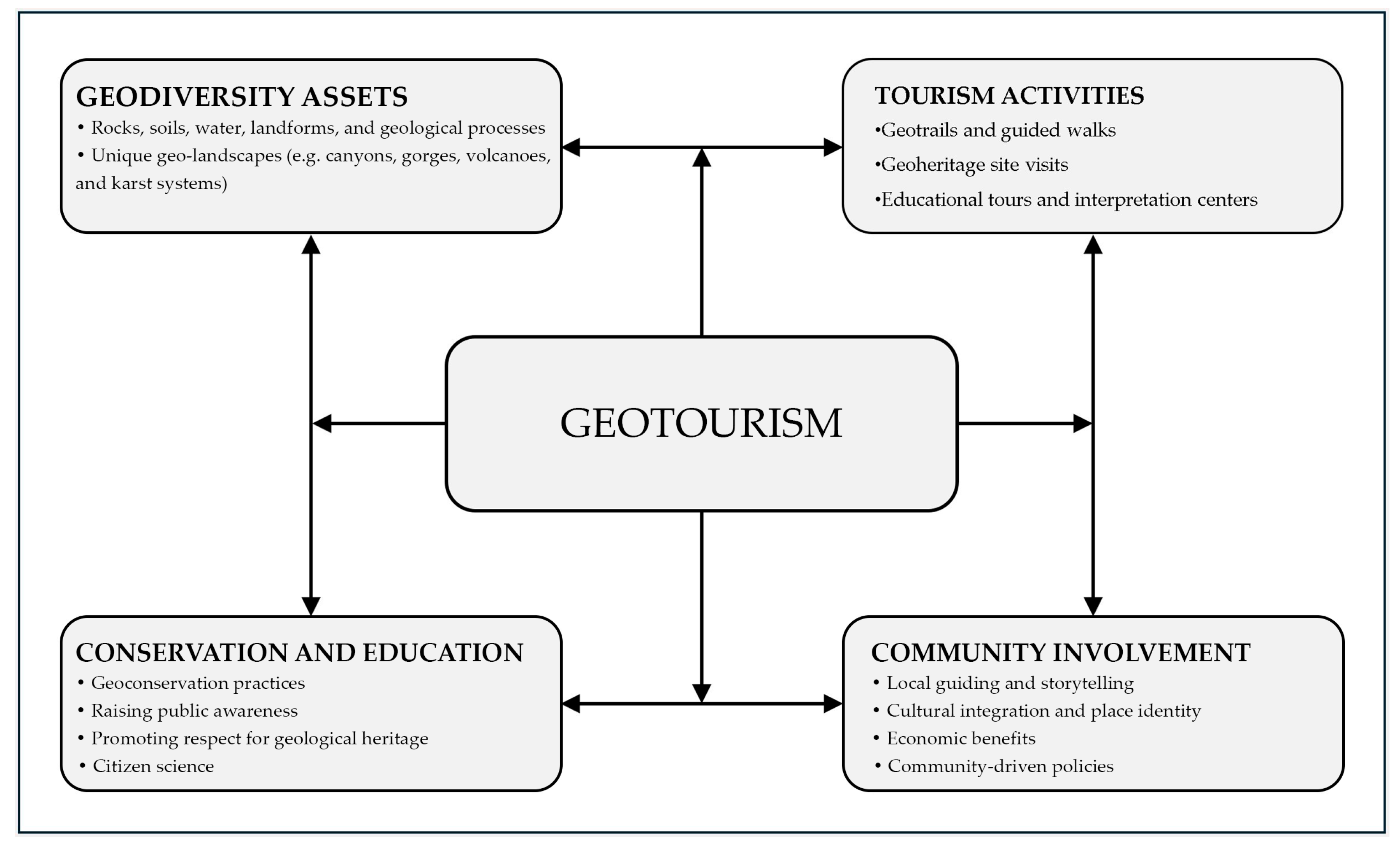
Considering increasing tourism pressure on sensitive geological environments, geotourism has emerged as a responsible and educational form of traveling that aims to protect geological heritage while fostering a deeper understanding of Earth’s physical features and their cultural significance [
18,
19,
20,
21,
22,
23,
24,
25]. By promoting interpretive practices and locally grounded experiences, geotourism reinforces the connection between landscape, heritage, and community identity. Geotourism initiatives are typically developed through partnerships between local communities, researchers, and decision-makers. These collaborations contribute to the creation of strategies that combine resource protection with social and economic benefits [
9,
26]. While tourism can enhance the visibility of geological heritage, it also introduces additional pressure on sensitive landscape components. In response, practical geotourism initiatives often include interpretive panels, structured trails, local guide training, exhibitions, accessibility improvements, visitor facilities, and physical protection measures, all designed to increase awareness of geological processes and encourage respectful interaction with natural sites. For geotourism to be successful, it must balance access with conservation [
27] (
Figure 1).
Scholars and practitioners emphasize the need for spatial planning, zoning, and controlled access in order to reduce environmental impact on vulnerable formations [
20,
22,
23,
24,
28]. Where appropriate, visitor limits, defined pathways, guided tours, surveillance systems, and carrying capacity control measures are implemented to ensure both safety and conservation. Education remains central to these efforts, reinforcing the idea that even minimal disturbances can lead to lasting damage [
29].
Within the framework of geotourism, geosites represent fundamental assets, providing the physical and interpretive foundation for the promotion of geological heritage. Their conservation is essential not only for ensuring the continuity of geotourism activities but also for maintaining the scientific and cultural values associated with these sites. Although such efforts require sustained investment, they contribute to the long-term integrity of geosites, support local economies, and enhance the visibility of geological heritage at national and international levels [
1,
3,
4].
In light of this, the protection of geosites has become an increasingly important objective within international and European environmental policies [
30,
31,
32,
33]. This growing attention is reflected in a range of legal frameworks and management models that aim to safeguard geological heritage as part of broader landscape and sustainability goals. One of the most visible initiatives at the global level is UNESCO’s International Geoscience and Geoparks Programme, which supports the valorization and promotion of geologically significant areas through integrated strategies that combine environmental education, local development, and awareness-raising [
34,
35]. These geoparks promote cooperation between scientists, policymakers, and communities, offering practical tools such as interpretive trails, exhibitions, museums and interpretative centres, educational programmes, applied research to the community’s needs, geosite inventories, communication tools, and promotional or informational activities, all aimed at enhancing site management and engaging the public. Although geoparks do not replace regional or national protection mechanisms and rely on local legislative frameworks for conservation, they provide an international platform that fosters visibility and encourages a culture of geoconservation, even in the absence of binding commitments. In the European Union, several legislative instruments contribute directly or indirectly to geosites’ protection. Laws such as those on habitats, water management, and environmental impact assessments often require attention to geological and geomorphological components, particularly when these form the basis of ecological systems [
30,
31,
32,
33]. The European Landscape Convention further strengthens this approach by promoting an integrated understanding of landscapes as evolving environments shaped by both natural processes and human activity [
36].
Romania’s legal framework for nature conservation includes geological and landscape diversity as elements of national heritage. The Environmental Protection Law and subsequent legislation recognize the need for sustainable management of geological, geomorphological, and speleological features of scientific, ecological, and cultural value. Protected areas are defined in various categories, including national parks, nature reserves, natural monuments, and geoparks [
37,
38]. Haţeg Country UNESCO Global Geopark and the Buzău Land UNESCO Global Geopark illustrate how education, community involvement, and integrated management can support geoconservation.
The aim of this research was to assess the geosites within the territory of Țara Hațegului and to identify those with notable potential for touristic use, in order to outline priority areas for landscape conservation. This approach contributes to a better understanding of the relationship between geotourism development and the sustainable management of geological heritage in the region.
2. Research Area
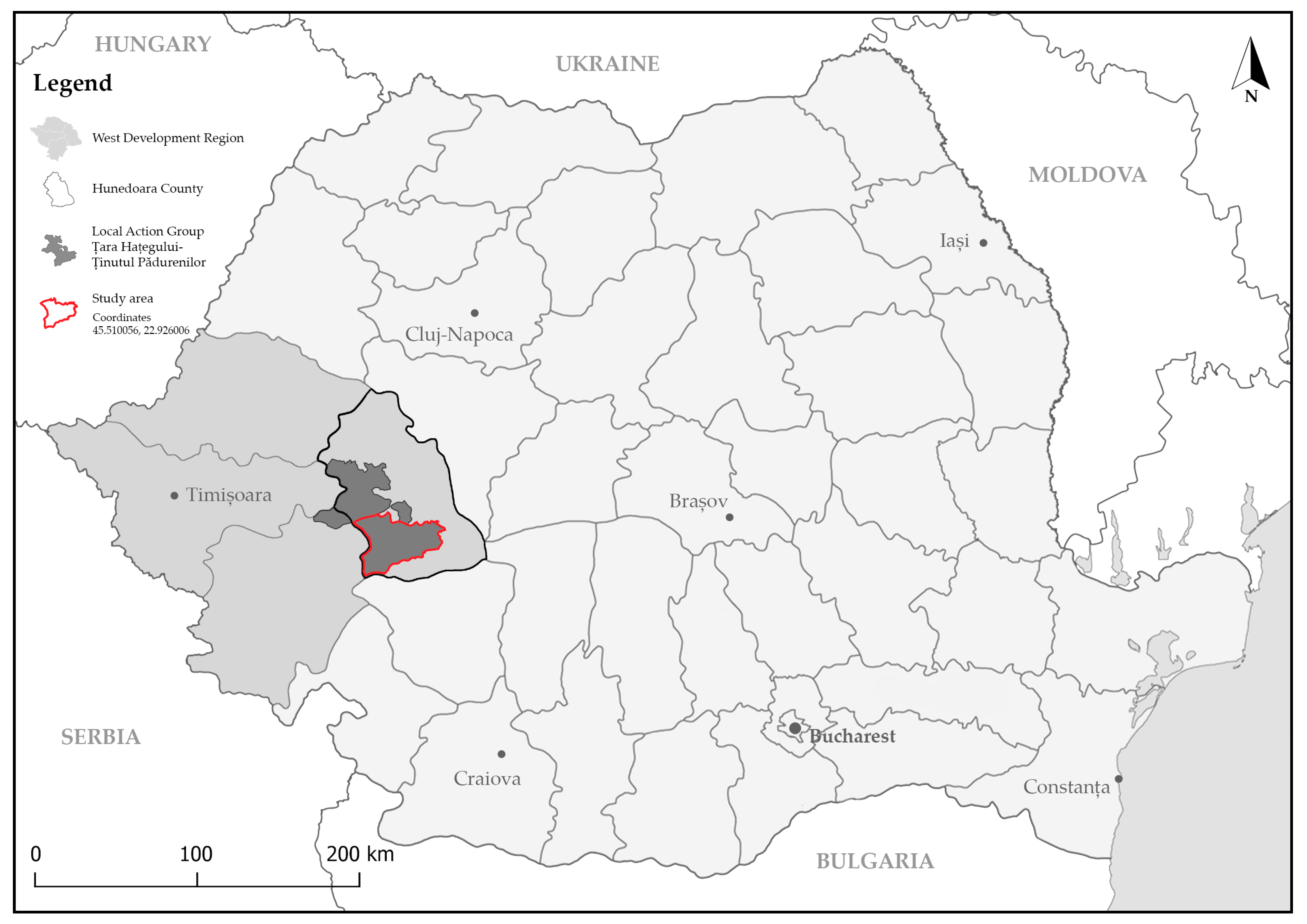
Țara Hațegului is a historical and geographical region located in Hunedoara County, western Romania (
Figure 2). The region corresponds to the Hațeg Depression, a distinct intermontane basin bordered by the Retezat Mountains to the south, the Țarcu Mountains to the west, the Poiana Ruscă Mountains to the north, and the Șureanu Mountains to the east and northeast. Covering an area of approximately 1300 square kilometres, the territory is traversed by the upper course of the Strei River and its tributaries, forming the physical landscape shaped by both ecological dynamics and geological structures [
39].
A significant part of this historical region overlaps with the Hațeg Country UNESCO Global Geopark, which not only encompasses its core geologic assets, but also integrates and promotes its remarkable cultural and historical legacy. Archaic settlements trace back to Neolithic times, with later influences from Dacian, Roman, and mediaeval communities. One of the most significant vestiges is Ulpia Traiana Sarmizegetusa, the ancient Roman capital of Dacia. Over centuries, feudal autonomy and the interplay of Romanian and Central European influences shaped the area’s architectural and societal identity, which endures today in stone churches (e.g., Densuș and Sântămăria-Orlea), historic fortresses, and vernacular structures that mark a deep-rooted sense of local heritage [
40,
41,
42].
Țara Hațegului presents a highly diverse geological framework shaped by over 500 million years of Earth history. This diversity results in a wide range of geological and paleontological features, which support the existence of multiple typologies of geosites, reflecting the area’s outstanding geoheritage [
18,
40].
From a geological perspective, the region encompasses a complete succession of rock types and geological processes, from Proterozoic metamorphic complexes and Paleozoic igneous intrusions to Mesozoic and Cenozoic sedimentary basins. The presence of igneous and metamorphic rocks, such as the Retezat-type granite and the Sebeș–Lotru Metamorphic Complex, forms the basis for petrological and structural geosites, representative of deep crustal evolution and orogenic processes. The extensive coverage of marine and continental sedimentary deposits, ranging from the Permian to the Miocene, gives rise to a wide range of stratigraphic and sedimentological geosites. These include red beds, coal-bearing layers, fluvio-lacustrine sequences, and limestone formations, each preserving indicators of paleoenvironmental transitions and regional geodynamic evolution [
18,
40].
The paleontological significance of Țara Hațegului is particularly remarkable. The region hosts numerous fossiliferous sequences with high scientific value. Marine invertebrate fossils, including ammonites, belemnites, gastropods, and crinoids, are preserved in Jurassic and Cretaceous deposits. However, the most distinctive paleontological elements are found in the Late Cretaceous continental formations, where the remains of the so-called “dwarf dinosaurs of Transylvania” have been discovered, along with crocodilians, turtles, pterosaurs (
Hatzegopteryx thambema), and unique nesting sites containing dinosaur eggs. These elements define a distinct class of paleontological geosites with global relevance [
18,
40].
Other geosite typologies can be associated with volcanic and volcaniclastic sequences, particularly those of the Densuș–Ciula and Sânpetru formations, where volcanic material interbeds with lacustrine and fluvial sediments. These units contribute to a deeper understanding of volcanic activity in post-orogenic continental settings [
18].
The diversity of lithologies, fossil content, depositional environments, and tectonic settings found within the Hațeg Basin highlights the presence of a complex and representative geoheritage. Together, they form a geodiversity-rich landscape within the Hațeg Country UNESCO Global Geopark, increasingly recognized as a destination for both scientific research and tourism.
Recently, Țara Hațegului has diversified its tourism strategies to promote its combined natural and cultural assets (
Figure 3). Geodiversity and biodiversity are now integrated into broader visitor experiences, which also highlight historical landmarks and rural traditions. Tourists can explore fossil reserves, engage in outdoor activities in Retezat National Park, or experience local culture by staying in traditional guesthouses, reflecting a shift toward sustainable, place-based tourism development [
40,
41,
42,
43,
44].
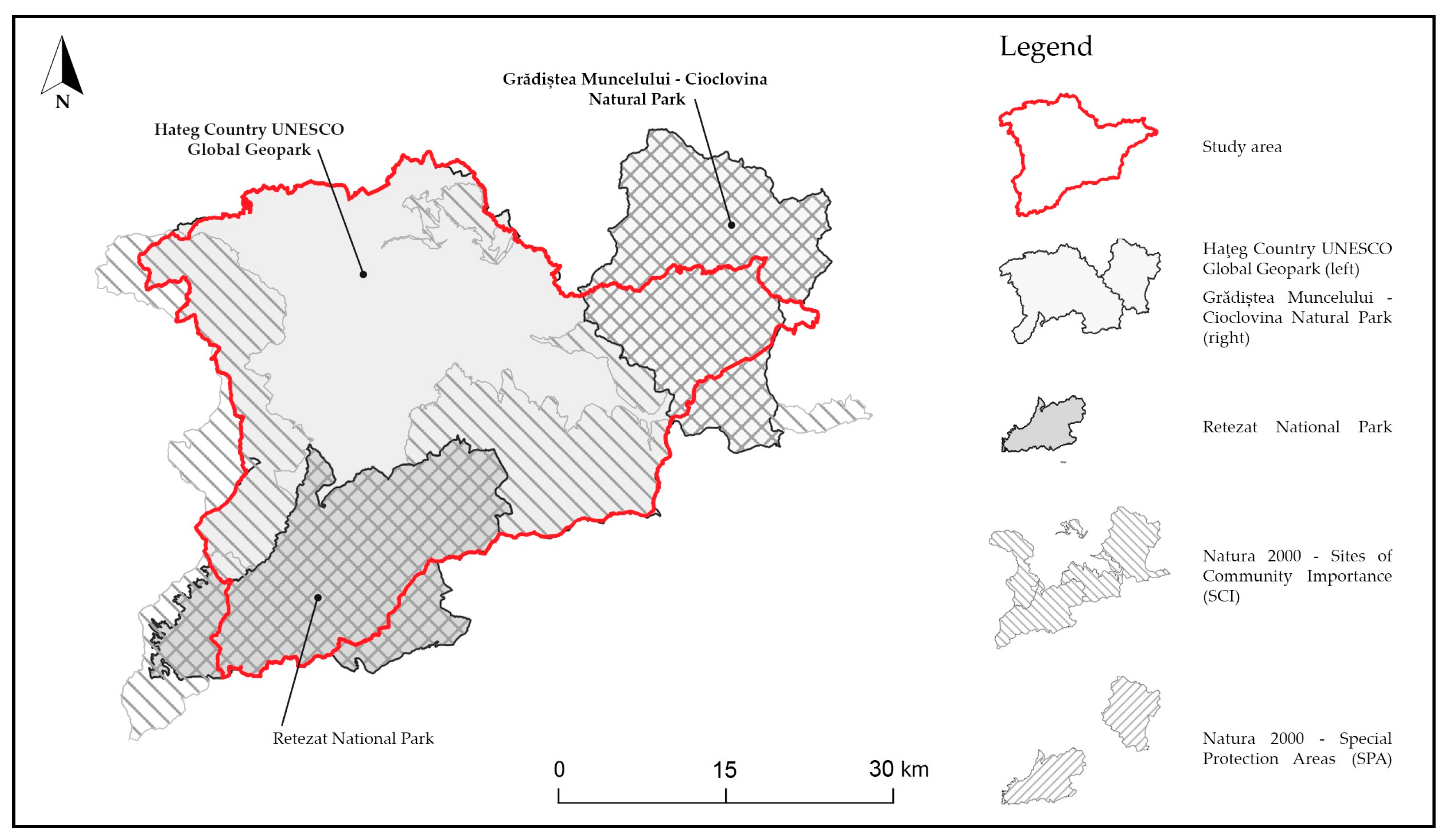
The increasing exposure of geological sites in Țara Hațegului to tourism has raised concerns about their long-term preservation, particularly in areas where access remains unregulated and infrastructure is limited [
45,
46]. To manage these pressures and protect the region’s outstanding geological, ecological, and cultural values, a multi-layered system of protective designations has been established (
Figure 4).
At the centre of this framework is the Haţeg Country UNESCO Global Geopark, designated as a UNESCO Global Geopark in 2015, which consolidates conservation efforts across more than 1020 square kilometres [
14,
42]. Through coordinated management of paleontological, botanical, and speleological reserves, supported by national legislation, the geopark ensures that geological heritage is preserved alongside biodiversity and cultural identity. The Haţeg Country UNESCO Global Geopark is administered by the University of Bucharest. In addition to the protection of geosites, the geopark supports a broad range of educational, scientific, and tourism-related programmes that promote geoconservation [
14,
40].
Complementing this framework, Retezat National Park is situated along the southern boundary of the Hațeg Depression. Classified as an IUCN Category II protected area, the park was established in 1935 and designated a UNESCO Biosphere Reserve in 1979. Covering approximately 381 square kilometres of alpine and subalpine landscapes, the park operates under a comprehensive management plan that regulates access, land use, and development activities [
48]. These measures aim to preserve glacial landforms and geological structures of high ecological and scientific importance. Increasingly, institutional collaboration between the national park and the geopark supports efforts to enhance ecological connectivity between the alpine ecosystems of Retezat and the geosites located in the lowlands of the Hațeg Depression.
Several Natura 2000 sites contribute to the regional conservation network. Among them, the Strei–Hațeg Site of Community Importance (ROSCI0236), designated in 2007, spans nearly 250 square kilometres and supports the conservation of habitats and species of European interest. This includes oak and beech forests, dry grasslands, and riparian ecosystems closely associated with underlying geological formations. In accordance with the EU Habitats and Birds Directives, all development projects within this area are subject to strict environmental assessment procedures [
37,
38].
The region’s cultural and historical heritage is also protected by national legislation. Valuable historic sites in Țara Hațegului are officially listed as historical monuments of national or local importance. Their conservation is overseen by the Ministry of Culture, which defines buffer zones, building restrictions, and restoration standards to ensure that cultural heritage is preserved alongside natural values [
49].
For geoconservation to be successful, it is essential to integrate spatial data on geodiversity into territorial planning and conservation strategies in a more dynamic and systematic way. Equally important is the active involvement of local communities, both in the decision-making process and as direct beneficiaries of geoconservation efforts. This involves not only updating existing management plans to reflect recent scientific findings but also ensuring that geological heritage is represented adequately in zoning regulations, land-use policies, and tourism development frameworks. Strengthening the connection between geoconservation and local development priorities and promoting inclusive collaboration between scientific institutions, local administrations, protected area managers, and communities are key steps toward improving the effectiveness and long-term sustainability of conservation efforts.
Enhanced public awareness and stakeholder involvement are a fundamental step toward geoconservation, supporting long-term protection goals by fostering a shared understanding of the significance of geological heritage. Education, community-based monitoring, and the inclusion of geodiversity in environmental impact assessments should become standard practice, particularly in regions experiencing growing tourism flows. In this context, regularly evaluating how geological assets align with current protection measures becomes not just a technical task, but a fundamental step toward sustainable development.
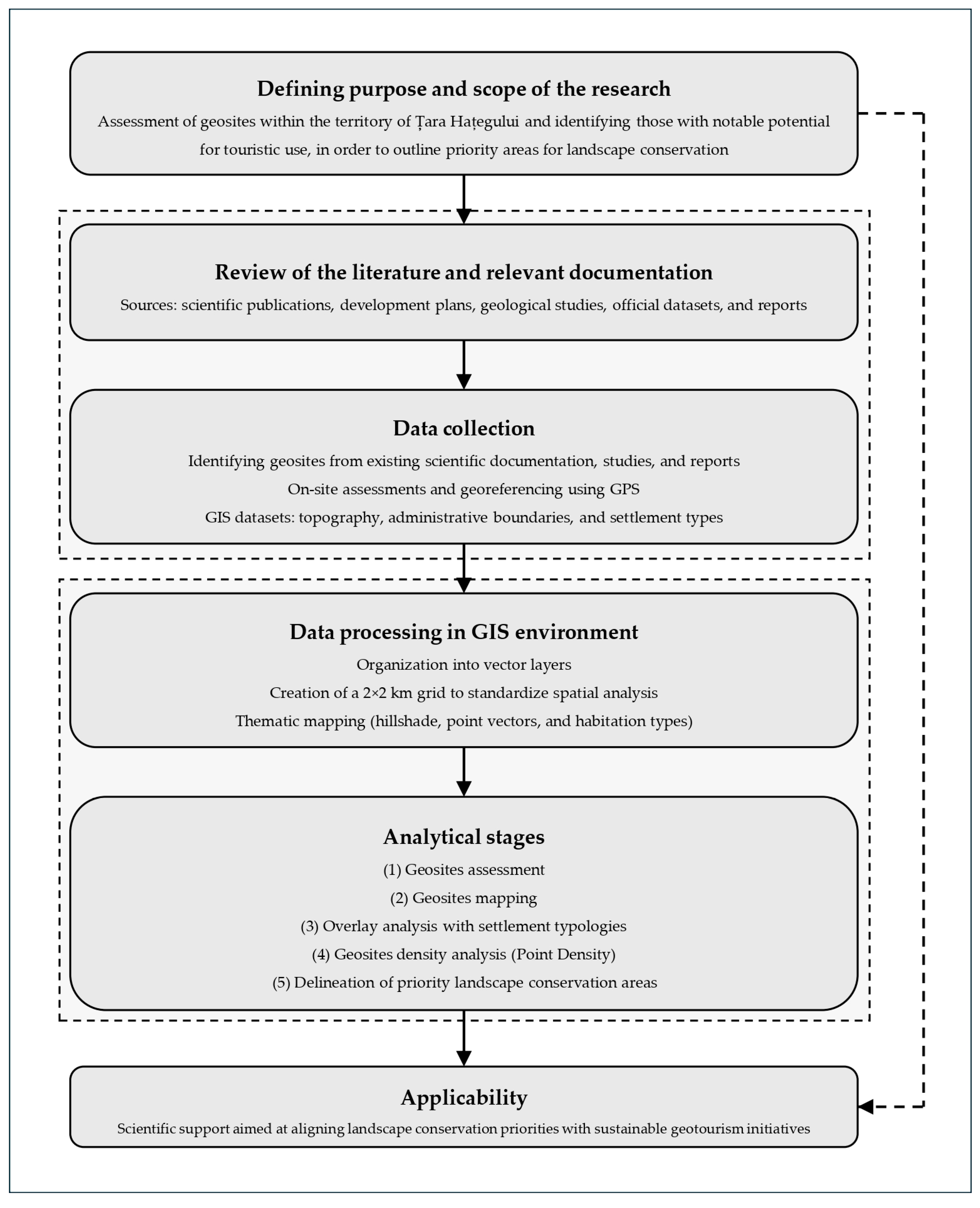
3. Materials and Methods
This study employs a structured methodological framework combining spatial analysis, quantitative approach, and site-specific evaluation techniques. The primary objective was to assess the geosites and to identify those with notable potential for touristic use, while also delineating areas of priority for landscape geoconservation. A schematic representation of the methodological process is provided as follows (
Figure 5).
The analytical structure consisted of five interrelated stages including (1) geosite assessment, (2) geosite mapping, (3) overlay analysis with settlement typologies, (4) geosite density analysis, and (5) delineation of priority landscape conservation areas:
This was the first stage of the methodology and was focused on the identification and documentation of geosites across the study area. These geosites were subsequently assessed based on the methodological framework proposed by Brilha [
1], which emphasizes the importance of contextual and functional attributes in determining the relevance of a geosite for geoconservation and geotourism. These attributes were used to assign each geosite to one of three categories of Potential Touristic Use (PTU): high, moderate, or low.
- 2.
Geosite mapping
This was the second methodological step and was focused on the spatial representation of the geosites previously identified and assessed, by integrating them into a Geographic Information System (GIS) environment to support subsequent stages of spatial analysis.
- 3.
Overlay analysis with settlement typologies
The third stage was focused on analysing the relationship between geosite locations and local settlement patterns. In order to ensure spatial uniformity and facilitate objective comparison across the study area, a standardized 2 × 2 kilometre grid was applied. This grid served as a neutral spatial unit that avoided inconsistencies introduced by administrative boundaries, allowing for more reliable integration of geosite data with contextual land use and settlement information. Geosites were analysed in relation to various settlement typologies, categorized as urban, rural, or uninhabited. This overlay analysis, conducted using QGIS 3.32.1 software, provided insight into spatial patterns of accessibility, potential human impact, and land-use compatibility, facilitating the identification of context-specific opportunities and constraints for geotourism development.
- 4.
Geosite density analysis
The fourth stage involved a spatial analysis of geosite distribution patterns across the study area, aimed at identifying zones with higher or lower concentrations of sites. Using the Point Density algorithm in QGIS, the number of geosites within each grid cell was calculated and visualized through a geosite density map. This representation allowed for the detection of spatial clusters, isolated occurrences, and underrepresented zones, thereby supporting a comparative evaluation across the territory.
- 5.
Delineation of priority landscape conservation areas
The final stage of the methodological process aimed to identify priority areas for landscape conservation by synthesizing the results of the quantitative assessment and density analysis. This integrative approach allowed for the classification of territorial units according to their combined geotourism potential and conservation relevance. Collectively, the methodological components provided a robust analytical foundation aimed at aligning geosite conservation priorities with sustainable geotourism initiatives.
4. Results
4.1. Geosite Assessment
The first stage of the research focused on the identification and documentation of geosites within the Țara Hațegului region, followed by their assessment. This phase combined an extensive review of the scientific literature, official reports, and protected area documentation [
11,
12,
18,
40,
50,
51,
52,
53,
54,
55,
56,
57,
58,
59], together with targeted field investigations. Based on this foundation, the assessment of the identified geosites was carried out to determine their PTU. The assessment was conducted in accordance with the framework proposed by Brilha [
1], which emphasizes the importance of contextual and functional criteria in determining the relevance of a geosite for both conservation and tourism purposes. To evaluate the PTU of each geosite, a quantitative assessment was conducted (
Table 1) using 13 specific criteria. These criteria include the following:
Vulnerability (A);
Accessibility (B);
Use limitations (C);
Safety (D);
Logistics (E);
Population density (F);
Association with other values (G);
Scenery (H);
Uniqueness (I);
Observation conditions (J);
Interpretative potential (K);
Economic level (L);
Proximity of recreational areas (M).
Each criterion was scored individually for all 48 geosites (G1–G48) on a scale from 1 to 4 points, depending on the presence and intensity of the attribute; a score of 0 was also possible. The final PTU score was calculated as the weighted sum of all individual scores (
Table 2), providing an objective basis for comparing the touristic potential across different sites.
The final PTU score for each geosite was calculated, in accordance with the framework proposed by Brilha [
1], using the following formula:
meaning that each criterion’s score was multiplied by its weight and all resulting values are summed to obtain the final score for each geosite.
The final PTU scores obtained ranged from a minimum of 185 to a maximum of 290. Based on this range, the sites were grouped into three categories:
This scoring system provided a standardized and objective basis for comparing the touristic potential of geosites within the study area, which led to the classification of 7 geosites as high, 13 as medium, and 28 as low. The resulting classification into low, medium, and high categories allows for a more nuanced understanding of how each site may contribute to future geotourism development strategies, while also supporting targeted planning and resource allocation based on individual site characteristics.
Additional data can be found in the
Supplementary Materials (Table S1). The dataset includes information on geosite names, codes, GPS coordinates, and the corresponding total scores of the PTU assessment.
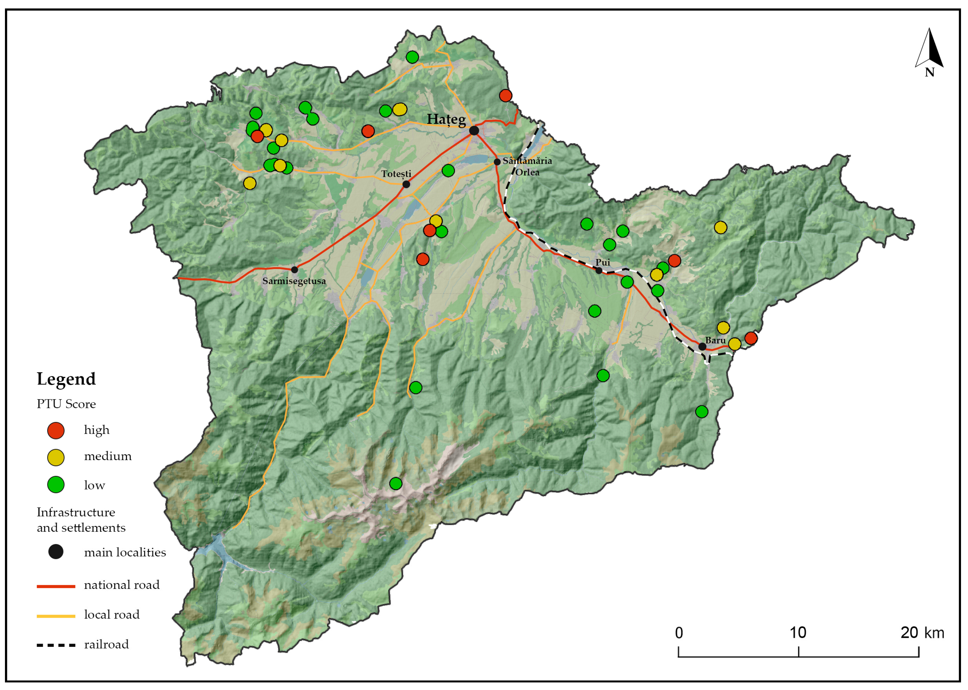
4.2. Geosites Mapping
The second stage of the research involved the spatial representation of geosites in the Țara Hațegului area, with the aim of analysing their distribution in relation to territorial features such as settlement patterns and accessibility. The resulting spatial dataset provided a foundational layer for subsequent analytical steps.
As illustrated in the resulting geosite map (
Figure 6), the spatial distribution of geosites across Țara Hațegului displays a notable degree of diversity, both in terms of concentration and territorial coverage. Certain areas exhibit more concentrated groupings, while others contain geosites that are more widely dispersed across the landscape.
From a broader perspective, this analytical stage underscores the role of geosites as structuring elements of the landscape and as valuable assets for sustainable tourism development. The analysis of the spatial distribution of geosites serves not only as a scientific tool for understanding territorial patterns, but also as a practical reference for planning geotourism initiatives. By accurately documenting their location, this step contributes to identifying areas of particular interest, evaluating potential human pressures, and informing geotourism development.
4.3. Settlement Typologies
The third stage of analysis sought to explore the relationship between geological heritage and the socio-territorial structure of Țara Hațegului (
Figure 7). This analytical layer aimed to contextualize the distribution of geosites in relation to patterns of human habitation, offering a more nuanced understanding of how settlement typologies may influence both access to geological resources and their potential for sustainable valorization through tourism, but also drawing attention to conservation-related aspects, as proximity to certain areas, such as urban areas, may increase the risks for conservation.
The rationale behind this stage lies in the recognition that the presence or absence of human settlements constitutes a decisive factor in determining the degree of exposure, accessibility, and conservation pressure experienced by geosites, while also potentially increasing their value as economic resources for tourism development. Consequently, the analysis was designed to examine how different categories of settlement, urban, rural, and uninhabited, interact spatially with the mapped geosites and what implications these interactions may have for planning geotourism initiatives. The classification of land use was performed by assigning each unit of the spatial grid a dominant occupancy type, using data derived from official planning documents [
50]. This settlement typology was subsequently intersected with the geosite map to analyse the occurrence and distribution of geological sites in relation to various settlement categories.
The majority of geosites are located in rural areas, which represent both a challenge and an opportunity, as their effective use and accessibility often depend on the condition of access roads and supporting infrastructure (
Table 3).
While rural settings may lack the infrastructure necessary for high-capacity tourism, their proximity to nearby urban areas can compensate by providing accommodation and complementary services. However, rural areas may offer favorable conditions for the development of community-based geotourism models, especially where local engagement and the integration of natural and cultural heritage are actively supported. While such initiatives are often associated with rural contexts, they are not exclusive to them and can be adapted to urban settings as well. A smaller number of geosites fall within urban contexts, where accessibility is generally higher, but the risk of landscape fragmentation and anthropogenic pressure is also more pronounced. A significant number of geosites are located in uninhabited areas, where the level of accessibility and availability of visitor services may vary depending on local terrain and infrastructure conditions.
By revealing the spatial relationship between geosites and settlement patterns, the analysis offers insights that may inform the identification of areas with potential for tourism development, as well as considerations related to conservation. It reinforces the idea that geotourism must operate within the existing socio-territorial matrix and adapt its strategies accordingly. In this way, the analysis contributes to a landscape conservation approach that respects the ecological, geological, and human dimensions of the region.
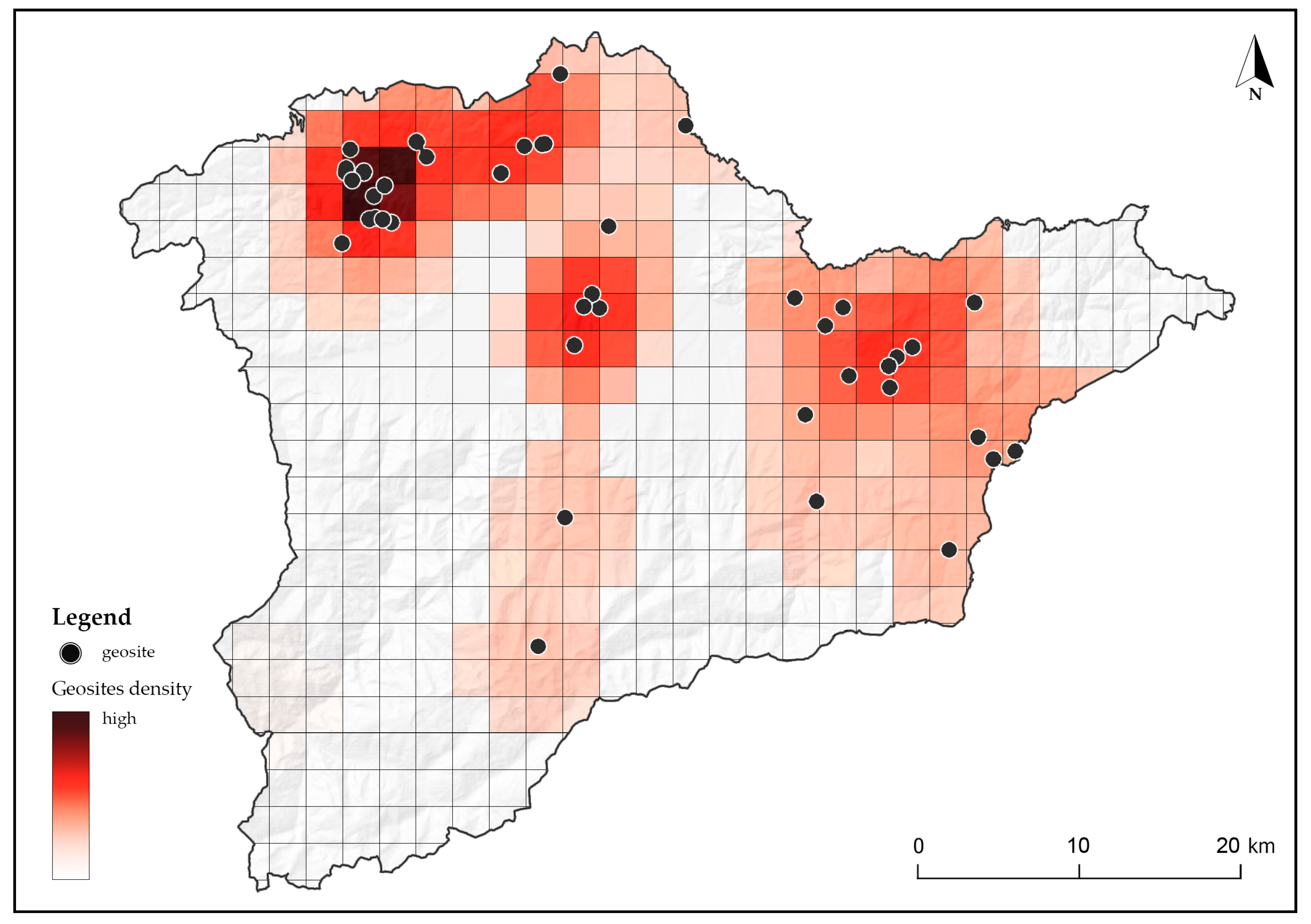
4.4. Geosites Density
The fourth stage of analysis focused on the spatial distribution of geosites across Țara Hațegului (
Figure 8). This phase aimed to identify areas with a higher concentration of geosites, supporting the interpretation of spatial intensity patterns relevant to territorial planning and site management. While these clusters provide a useful overview of areas with a higher concentration of sites, they encompass geosites with diverse characteristics, functions, and levels of public accessibility. As such, the visualization supports a contextualized approach to site management, where decisions regarding infrastructure, visitor access, and interpretation must be adapted to the specific values and sensitivities of each geosite.
The implications of this analysis are both theoretical and practical. From a theoretical perspective, identifying areas with higher geosite concentration contributes to landscape-based approaches in geoheritage research by illustrating the spatial unevenness of geosite distribution. However, the significance of these concentrations depends on the specific value and relevance of the individual sites, which may vary across local, regional, national, or international scales. On a practical level, the analysis serves as a valuable tool for planners, geoconservation practitioners, and local stakeholders. Identifying zones with higher geosite concentration can inform the planning of investments, interpretive routes, and protection measures, in line with each site’s value and context.
Furthermore, the density analysis can help guide resource allocation by indicating areas where interventions have the potential to enhance visibility, support educational initiatives, and encourage tourism activity, based on an assessment of the relevance and specific characteristics of each geosite. It also facilitates the integration of geodiversity considerations into broader territorial planning frameworks, ensuring that areas with dense geological assets are recognized not merely as scientific or environmental resources but as strategic components of regional development.
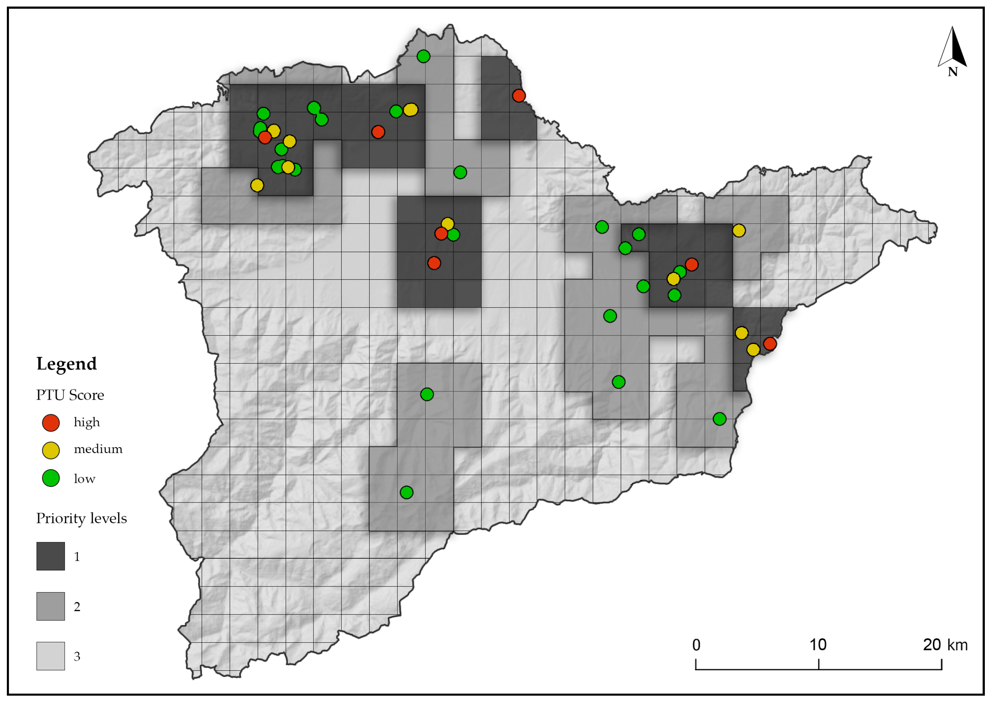
4.5. Delineation of Priority Landscape Conservation Areas
The delineation of priority landscape conservation areas represents the concluding phase of the analytical process, aimed at translating spatial data into a tool for territorial planning. This stage consolidates the results of previous analyses in order to identify areas where geotourism development may be pursued in a coordinated manner (
Figure 9).
The designated zones reflect the spatial intersection between geosite density and their assessed touristic potential, offering a basis for identifying areas where geotourism initiatives may be most effectively developed or supported.
Three priority levels were defined:
Priority level 1: areas where a higher concentration of geosites or higher PTU values suggests the need for proactive planning and monitoring, to balance potential use with preservation goals;
Priority level 2: areas with lower geosite densities or moderate PTU scores, where adaptive and locally informed approaches may be appropriate, depending on specific territorial conditions;
Priority level 3: areas without currently identified geosites, but which may be relevant in terms of maintaining landscape coherence or anticipating future pressures.
This classification is intended to guide planning processes by highlighting zones where geoconservation, interpretation, or sustainable tourism initiatives could be explored in accordance with site-specific conditions and regional priorities.
The approach adopted in this stage embraces a landscape-scale perspective, recognizing that geosites function not as isolated features, but as part of broader territorial systems that include ecological and cultural dimensions. As such, the resulting prioritization map is not prescriptive but offers a flexible tool to support coordinated strategies for natural heritage integration within regional development.
5. Discussion
The assessment of geosites have been widely explored in recent studies [
1,
2,
3,
4,
10,
27,
57,
58], particularly in connection with sustainable tourism planning and landscape conservation strategies [
3,
26]. These contributions highlight the importance of assessing geosites not only for their scientific and educational relevance, but also for their touristic value, especially when integrated into broader frameworks of territorial management and geoconservation [
28,
45,
59]. In this context, Țara Hațegului provides a representative case study, due to the diversity and international significance of its geoheritage. The primary objective of this research was to assess the geosites located within the territory of Țara Hațegului and to identify those with notable potential for touristic use, with the aim of delineating priority areas for landscape conservation. This objective has been addressed through a multi-stage analytical framework that integrated spatial data interpretation with site-specific evaluation.
The results of the assessment indicate that, out of the 48 geosites analysed, 7 were classified as having high PTU, 13 as moderate, and 28 as low, based on 13 evaluation criteria adapted from Brilha’s methodology [
1]. The 7 geosites identified as having high PTU reflect a varied typology of geoheritage: paleontological reserves (G23—Sânpetru fossiliferous sites; G30—Tuștea fossiliferous site), marine fossil and lithological sites (G5—Ohaba-Ponor Snail Hill), stratigraphic and sedimentological outcrops (G6—Silvaș Valley Badenian Deposits; G11—Quaternary Deposits—The Newest Sediments of the Hațeg Country), geomorphological features shaped by erosion (G47—Răchitova Trail), and tectonically uplifted Jurassic formations (G3—Crivadia Gorges). It is important to note, however, that the remaining geosites also hold significant geological value and should not be disregarded. They may contribute to conservation strategies, educational programmes, or local development in different ways.
While the classification provides a structured basis for setting priorities, it does not capture all aspects that influence the actual suitability of a site for tourism. The scoring reflects performance relative to selected criteria, but factors such as site management and community involvement may also play a decisive role. As such, the assessment should be understood as an initial step, an analytical tool that informs, but does not replace, more detailed planning and stakeholder-based decision-making processes.
Subsequently, the study aimed to integrate and analyse geosites spatially within broader territorial structures. A key component of this approach was the examination of the relationship between geosites and different settlement typologies. The data revealed that out of the 48 identified geosites, 30 (62.5%) are located in rural areas, 16 (33.3%) in uninhabited zones, and only 2 (4.2%) in urban contexts. Notably, among the 7 geosites evaluated with high PTU, 5 are situated in rural areas, while the remaining 2 are found in uninhabited zones located in immediate proximity to rural settlements.
To further enrich this analytical framework, a geosite density layer was developed. The resulting density map identifies zones with a higher concentration of geosites, which may function as strategic focal points for integrated tourism and conservation initiatives. Although geosite density does not inherently reflect heritage value, such areas offer favorable conditions for the efficient implementation of coordinated planning, infrastructure development, and interpretive strategies.
The final stage involved delineating priority landscape areas based on combined geosite density and PTU values. These are not formal protection zones but planning references indicating where coordinated management may be needed. High-priority areas suggest the need for proactive intervention, yet even sites with high PTU may face access or infrastructure challenges. Conversely, lower-ranked sites can gain relevance through local interpretation and engagement.
To summarize and clarify the research findings, a SWOT analysis was conducted, outlining the key dimensions of the studied geosites:
S1: Diverse geological and paleontological features;
S2: The presence of UNESCO Global Geopark, National Park, Natural Park and Natura 2000 sites ensures a robust, multi-layered protection framework;
S3: Geodiversity, biodiversity, and cultural heritage are combined for holistic visitor experiences.
W1: Limited infrastructure in rural and uninhabited areas, affecting accessibility and visitor experience;
W2: Restricted physical access to some geosites due to terrain or seasonal limitations;
W3: Insufficient monitoring tools to assess geosite condition and manage tourism-related impacts over time.
O1: Growing interest in sustainable and nature-based tourism, aligned with global trends seeking authentic and educational experiences;
O2: Availability of funding programmes, particularly at the European level, supporting conservation, infrastructure, and rural development;
O3: Emerging digital tools (e.g., mobile applications, virtual tours) to enhance interpretation, visitor engagement, and outreach beyond physical constraints.
T1: Increasing tourism pressure, especially in the absence of regulation or visitor management systems, may lead to site degradation;
T2: Limited financial and human resources for ongoing site maintenance, protection, and interpretation;
T3: Anthropogenic threats, including habitat fragmentation, uncontrolled land use, and infrastructure development in sensitive areas.
The SWOT analysis synthesizes the key factors influencing both the current status and future potential of geosite management in Țara Hațegului. The findings of this research provide a solid foundation for informed planning and strategic decision-making, while also identifying critical areas for improvement. Moving forward, priority should be given to the development of monitoring systems capable of tracking geosite condition and usage over time, particularly within high-priority zones. Furthermore, the integration of qualitative insights, such as stakeholder input and visitor feedback, alongside dynamic indicators like tourism flows and community engagement, will be essential for advancing more adaptive, responsive, and context-sensitive planning frameworks.
6. Conclusions
This study examined the role of geosites in Țara Hațegului, aiming to contribute to a development perspective that integrates geotourism with landscape-oriented conservation. Through the analysis of spatial distribution, settlement context, and touristic potential, the research offered a structured perspective on how geological heritage can inform broader planning and management discussions.
The results showed that only 7 out of the 48 geosites assessed exhibit high PTU. However, the density patterns of these geosites may hold relevance for future territorial planning, depending on the specific development objectives and local contextual factors. These areas offer possible entry points for initiatives that link geological heritage with educational and recreational experiences, provided that such efforts are supported by appropriate infrastructure and management considerations.
A key contribution of the study is the formulation of a methodological framework for the spatial organization and prioritization of geosites. The integration of the touristic potential assessment, density analysis, and the delineation of priority areas offers a basis for informing future strategies in conservation, tourism development, and territorial planning. While the approach provides valuable insights, its effective application will depend on a range of factors, including available resources, institutional capacity, and stakeholder involvement.
Rather than offering prescriptive solutions, the study proposes a flexible planning instrument that can support informed reflection and further exploration. As such, the outcomes are intended to serve as a reference point for adapting geosite-related strategies to the specific characteristics and evolving needs of the local landscape.


